102


HTHE GEOLOGY OF THE PICK3T0NE GOLD MINE
HARTLEY DISTRICT
RHODES IA
BY
R *8 ♦ JOHNSON
JOHANNESBURG
1967
A THESIS SUBMITTED FOR THE DEGREEOP
M S TER OF SCIENCE
IN THE FACULTY OP SCIENCE
UNIVERSITY OP THE WITWATERSRAND
(i)

DECLARATION
I, Ronald Stanley Johnson, hereby declare that this thesis is my own work, and has not been submitted previously for any degree in any university,
Sfl>V.
Signer1 .
(11)

'
I ABSTRACT
The Pickstone Gold Mine is situated in the Concession Hill Mining Reserve, 20 miles east-northeast of the town of Gatooma, a mining and farming centre in the Midlands district of Rhodesia,
The Pickstone deposit is a sulphide replacement deposit in a banded jaspilite host rock and is situated on the steeply dipping southern limb or the Eastern Hartley synform. The banded jaspilite host rock is an interlayered sediment in the volcanic rocks of the Bulawayan System, ea rly Precambrian in age, and is composed of narrow parallel and alternating cards of fine-grained siderite and cryptocrystalline quartz.The origin of this non-detrital rock is obscure, but the majority of hypotheses relating to vhese banded iron formations, favour a sedimentary origin by cnemicalprecipitation.
Intrusion and updoming by the surroundinggranitic batholiths subjected this relatively competent banded jaspilite to compressive forces resulting in the development of toudinage structure normal to the compressive stress. The tensile stress developed intensive fracturing in the relatively narrow zones (pinched zones) between the bcudins, forming channel- ways for the mineral: ed fluids to permeate, the sulphides showing preferential replacement of the chemically favourable siderite bands in the jaspilite host rock. The close relationship between the structure of the banded jaspilite host rock, depicted by

.
J
isopachs at 5 leet intervals, and the ore shoots plotted on a vertical projection of the Pickstone Mine are clearly illustrated. The trends of these isopachs show thu relationships of the non-mineralized bondins (swells) and the mineralized pinched zones, and this has proved a useful guide in predicting the trends of the ore shoots. Although the ore shoots are continuous in the vertical plane they fluctuate continuously within the broad host rock and to overcome the acute dilution problem encountered using underhand stoping, sub-level stoping was introduced below 10 level. Methods which have been used for the beneficiation of the ore are described including the present method of discarding about 10 per cent of the rock mined by hand sorting.
The rocks of the Pickstone Mine area are generally very fine-grained and have been altered by metamorphism. The banded jaspilite has narrow parallelbands of light and dark coloured material. The mineral composition of the dark bands was determined by X-ray Diffraction analysis and shown to be siderite. Observations of the light coloured bands under the microscope showed them to consist of cryptocrystalline quartz. Although macroscopically the contacts between these bands appear fairly sharp, mixing of the quartz and siderite grains was often observed under the microscope. Thin sections cut on mineralized specimens of banded jaspilite showed that there is preferential replacement of the siderite bands by the sulphides. The south wall-rock of the Pickstone orebody is a highly foliated

w
:\nd cilterou rock? which is considered to have been derived 1 »soxn the alteration of a closely associated falsite and quartz-porphyry• X-ray Diffraction analysisdisclosed that this south wall—rock consists predominantly of pyrophyllite (basic aluminium silicate), The north wall—rock 01 the lickstone orebody is a speckled chlorite schist presumably deiived from the alteration of a basic igneous rock. Crushed relics of felspar altering to sericite, which are e 'eloped by chlorite, give this rock a speckled appearance.
The ore minerals identified from microscopic examination of polished sections \ .re arsenopyrite, pyrite, chalcopyrite, sphalerite and gold. J:ne predominant ore minerals are arsenopyrite and pyrite, and these two minerals generally display subhedral and euhedral crystal faces, the contacts between lose crystal faces usually showing an interlocking of these two minerals with each other, Microscopic observe cions of these ore minerals suggest that the two minerals crystallized out more or less contemporaneously and that the amount of arsenopyrite slightly exceeds that of the pyrite. Gold is present in extremely fine form as irregular grains, usually from 15 - 5v microns in diameter as inclusions in and between inter.! •cning crystals of the arsenopyrite and pyrite• free gold was observed associated with the l^te milky vein-quartz gangue, but such occurrences are rare„ The origin of the gold is considered to be related to the invading granitic bodies, the gold-bearing solutions presumably
(v)

expelled under high pressure from below the developing hoods of the granitic batholiths.
Assay results of the fineness of the gold and silver in parts per thousand obtained from the sampling of gold bars together with the calculated impurities I iron, copper, and nickel), show that the fineness of the gold fluctuated strongly during certain periods, while the silver content remained relatively constant at all times, leading to the conclusion that there is ar\d«see± inverse relationship between the fineness of the gold and the content of base metal in the ore,
The total gold recovered up to the end of 1966 was 242,373*38 ounces from 1,271,637 tons milled giving an average recovered grade of 3•81 pennyweights per ton milled.

II. CONTENTS
PageI. ABSTRACT................... (ill)II. CONTENTS................... (vii)III. INTRODUCTION ................. 1IV. LOCATION AND GEOGRAPHY ... ... ... 2V. HISTORY OF THE PICKSTONE M I N E ........ 4VI. AN OUTLINE OF THE GEOLOGY OF THE
EASTERN HARTLEY GOLD-BELT ....... 7(a) General(b) Geology(c) Historical Geology
VII. THE GEOLOGY OF THE PICKSTONEMINE AREA .. ... ••• ••• -7
(a) Introduction(b) Stratigraphy(c) Petrographic Description of the
Rock-Types(d) Structure(e) Metamorphism
VIII. GOLD MINERALIZATION........ * • • • • • 39(a) Host Rock(b) Microscopic Relationships of the Ore
Minerals(c) Origin of the Gold
IXe STRUCTURE-CONTROLLED ORE SHOOTS ... 51
(a) Introduction(b) Venning Ore Shoots(c) Concession Ore Shoots
>
(d) Pickstone East Ore Shoots(e) Conclusions
(vii)

X I .
XII.
(a)(b)(c)(d)
MINING VALUATION AND UPGRADINGlining MethodsMine Sampling Methods of Upgrading Gold OutputsACKNOWLhPGiliENTS.................................................
Page64
t • • • • • • • • • « e
7879
GEOLOGICAL FL-vIo .. . . FIGUItESPICKS TONE MINE LEVEL
PLANS • • • • t • . FIGURES 11PICKSTONE MINE VERTICAL
PROJECTIONS ... . FIGURES 4 and 12GRAPHS ................ FIGURES 13HISTOGRAiiS .PHOTOGRAPHS
# * e e * e . FIGURE . PLATES
1516V
PHOTOMICROGRAPHS OF THE TE..N Sr.OTIJNS . ...
PHOTOL. ICROGRAPHS U' THE. PLATES VI - XIV
POLISHED SECTIONS .. . PLATES XV XX
(viii)

III. INTRODUCTION
The Pickstone Gold Deposit, although one of the earliest to be mined in Rhodesia, has only very recently achieved recognition as a major gold producer in this country. The reasons ior this are the highly refractory nature of the sulphide ore below the oxidised zone, the difficulties of avoiding ore dilution during mining operations, and the introduction of beneficiation of the ore# No detailed geological investigations were conducted on this gold deposit prior to 1961, when an intensive geological study was undertaken involving a programme of diamond drilling to provide further information on the structure, continuity and mineral contentof the orebody.
The results of the geological study further indicated the possibility of a substantially large tonnage of ore being present. Prom this study it became evident that the position of the ore shoots in this deposit was controlled by structural conditions and this proved a useful guide to ore in the subsequent development programme of t1 e mine. Investigations into the beneficiation of the ore were conducted and at present upgrading of the ore is achieved by hand sortingof waste material.

IV. LOCATION AND GEOGRAPHY
Picks tone iVine is situated in the Concession Hill Mining Reserve, 16 miles south-southeast of the small town of Hartley, and 20 miles east-northeast of the town of Gatooma. The main Salisbury - Bulawayo railwayline and national road pass through these two towns, the mine is linked to both towns by good secondary roads (Figure 1).
At present, the majority of the major gold- producing mines in Rhodesia are clustered around Gatooma and Hartley, namely the Cam & Motor, Dalny, Pickstone, Patchway, Golden Valley and Giant Mines,
The Pic/cstone Mine is situated at an elevation of 3,900 feet above sea level. The surrounding country is generally fairly flat, with a number of low parallel ridges running in i general east—west direction and rising to a maximum elevation of 150 feet above the surroundings• These are formed by resistent inter- layered siliceous sediments and narrow grit bands in the more easily weathered metamorphosed basic, and ultrabcxsio lavas. Undifferentiated sediments on the northern side of the Pickstone Mine weather to form a very even surface consisting essentially of a clayey-type soil, and to the south there is an extensive region of weathered granite country of mature landscape, Lix miles east of the Pickstone Mine is the world-renowned geological feature, the Great Dyke, which in this area forms a slightly elevated topographical feature. This surrounding country is described by L. C. King (1962) as a pediplaii: which

tonns prirt oi the late - Cainozoic geomor^ >logical surface•
The rainy seat a extends over the five months from November to "arcn, with a mean annual rainfall for the period I960 to 1967 of 25 inches.
The Mombi River* a tributary of the westerly flowing Urnswewe River, was superimposed transgressively on the o3der formation of schists and granite consisting of ancient PrcCambrian rooks, from a younger covering of Karroo rocks, remnants of which are to be foun east of the Great Dyke.
Savannah type vegetation includes the pani (Colophos^ rum Jopani), occupying the low granite country, with the Hfuti (Brachystegia Boehmii), and TIsasa (Brachystegia Spiciformis), both relatively tall trees, growing on the low ridges of these ancient rocks. The last two trees mentioned are cut locally, and used as a cheap fuel for the Africans employed on the mines of the area.
Dry-cultivation farming is carried on in the region, the chief crops grown being maize, cotton and tobacco. Cattle ranching is gaining rapidly in importance, and contributes greatly to the farming industry. Secondary industries comprise cotton milling and textiles.

g e o l o g i c a l m a pOF
c e n t r a l p o r t i o n o f r h o o e s i a
v v
L O C A L I T Y p l a nMAP OF RHODESIA
/ / .U J//
f sbur6 < % / / / / !Got >oma
// f 'Que Ou /^7/ /Pickstone
MineBulawayo
ZSALISBURY
18* S.
LEGEND
MAR'LtKALAHARIA eo l ian sands
ICKSTONO O] Basalt
KARROO r11111 lllll Grits,sends' .onei
^ u Q o s t o m l t e s .slates t q u a r t z i t e s LOMAGUNDI
II
}3 F t y l U t e s .s lQ t e s .q u a r t z i tesE P I R I W I R I
SHAMVAIA NGri ts,erllcose,slates
BULAWAYANM e t a v o I c o n i c s . i n t e r b e d d e d s e d i m e n t s
S E B A K W IA NAmphi bol e schist , s e r p e n t i n e
i X ^ 1 G r a n i t e s (various ages )
%IG N E O U S I N T R U S I V E S
XE Nori t e t g abbr o#./GT. DYKE
eRy- o e n i t e ^ s e r p e n t i n e
— r e f e r e n c e - TAK E F R O M PROVISIONAL MAP OF SOUTHERN RK j
GEOLOGICALP- s i l way
T owns

4
V. HISTORY OF THE PICKSTONE MINE
The original Picks tone Ivline claims were pegged in 1905 on ancient workings, situated approximately 1,000 feet east of the Burnett Shaft, and north of the banded jaspilite ridge known as Duchess Hill (Figure 3). The ore deposit comprised narrow, branching lenses of vein-quartz in highly sheared greenstone lava, which dipped approximately 80° south, and converged on the banded jaspilite westwards along strike, According to A , E • Zoalley (1918), the quartz reefs were phenomenally rich in places, with seams of gold up to one-eighth inch wide, Gold was first produced in 1907 when 544 tons of ore crushed gave 455 ounces of gold. Pyrite, mispickel and galena were present in Small quantities.
In 1908, presumably with the spread of mining activities westwards to the banded jaspilite contact, a new orebody, known as the Pickstone Vest was discovered.No "ancient” workings existed on this orebody, which on outcrop was a large lense—shaped body oi solt ferruginousgossan, with paint gold showings.
Mining operations on the Pickstone East, viz. the quartz reefs, had reached the 200 feet level by 1910, and it is recorded that gold values became erratic and poorer as the depth ol the mine increased. By 1 JO 1 the Pickstone West, viz• the ferruginous gossan, was developed to the 100 feet level end a trial crushing that year of 500 tons gave an extraction of 7.0 dwts./ton. In November 1911, the property vvas taken over by che L. S. Syndicate, who acquired a f interest from

C, Swarton and a 4 interest from I* Minnaar.The Pickstone Gold Minos Lxd• was registered
in August 1912, with an authorised capital of £50,000.Ir 1914 it was reported that three orebodies had beendeveloped. It is necessary at this stage to clarifythe names of these orebodies and their relationships tothe present-day orebodies or ore shoots• The originalPickstone II: st, comprising the vein-quartz reefs, ceasedmining operations in 1915 due to poor values at depth.Tne Pickstone "Vest, developed on the soft ferruginousgossan, are the surface showings of the present-dayPickstone East ore shoots• The third orebody, knownas the Concession Hill East Extension, a continuationwest of the ferruginous gossan, represents the present-day Venning Ore Shoots at surface level.
The plant consisted of ten stamps and twoChilian Mills with a capacity of 6,000 tons per month.With mining operations attaining greater depths, thesemi-oxidised ore became increasingly refractory andgold recovery was only 63 percent• Mining operationswere stopped between 1915 and 1918. The companyrelinquished the claims in 1926, as it was realisedthat an all-sliming plant was necessary to deal withthe refractory sulphide ore.
The sands and slimes dumps were retreeted byR. Sutherland from 1928 to 1940, and stopped witn tbaonset of World War II.
In 1948, a syndicate of companies, includingLondon and Rhodesia Mining and Land Company Ltd.,acquired the Pickstone Mine and favourable results fromfive surface boreholes, covering a strike of 960 feet,

6
led to the dc-watering of the old Picvstone West#In January 1952 it became the property of the Cam and Motor Cold Mining Company (1919) Ltd,
Shaft sinking with subsequent underground development proved’ a considerable tonnage of payable ore, and construction of a reduction plant started in October, 1954. The plant, with a milling capacity of 7,000 tone per month, provided direct cyanidation of the finely ground arsenical concentrates, and came into operation in April, 1956, By 1958 both the Burnett and Southwell shafts were down to 7 level (950 feet below surface).
In 1959, the Rio Tinto Mining Group acquired the Cam and Motor Cold Mine, and the Pickstone Mine was included in the acquisition. No previous detailed geological mapping had been undertaken of the Pickstone Mine workings, and the underground surveying and sampling was administered by Cam and Motor Mine staff, Geological mapping of the Pickstone Mine was up to date by the middle of 1962, combining mapping of the main drives and the geological recording and assessment of the results of the programme of diamond drilling of the wide banded jaspilite host rock, Increased knowledge of the behaviour of the Pickstone ore shoots led to improved mining methods, upgrading of the ore, and the mine plant enlarged to millapproximately 15,000 4" ns per month.
At present the Pickstone Mine may be classifiedas a low grade, medium to high tonnage—range gold mine, and is one of the larger gold producing mines in Rhodesia,

7
VI. AN _ OUTLINE OP TliE mOT.nr! OP THEEASTERN HARTLEY GOLD - BELT
(a) GeneralThe Hartley area derivej its name from the well-
known elephant hunter Henry Hartley, who in the 1860’s made frequent hunting trips to the north from his Transvaal farm. Having located extensive ancient” workings, approximately eight miles east of the present town of Hartley and close to the western edge of the Great Dyke, Hartley invited Carl I-Iauch, a German geologist to investigate these workings. Mauch confirmed the presence of gold in these ’’ancient” workings, and they became known as the "Northern Goldfields”. Mining only commenced in 1890, but soon moved to the richer goldfields discovered around Gatooma.(b) Geology
The Basement Complex, which comprises the gold- belt schists and surrounding granites, is exposed over more than half of the total area of Rhodesia (Figure 2). Mapping of these geologically important gold-belts has disclosed a close resemblance in rock types, structures, and geological events. Dr. A. M. Macgregor, a former Director of the Geological Survey, established a geological subdivision for these Rhodesian gold-belts.In 1957, J. W. Wiles published a description of the Geology of the Eastern Hartley gold-belt, a summary of which is given below. He correlated the rocks in

accordance wixh Dr, A, M , M&cgregor1 a subdiv.i8ion as follows
Upper Sedimentary Series
Upper Greenstone Series Middle Sedimentary Series
Ultrabasic Intrusives lower Greens' me Series Lov/er Sedimentary Series
SEBAICWIA.N SYSTK
Lov/er Sedimentary Series
The rocks are predominaiitly banded ironstones with minor politic sediments. Granite assimilation coupled v/ith erosion have left only a few remnants of these rocks mainly in the southeast section of une gold- belt adjacent to the Great Dyke, and within the serpentine xenoliths in the granite south of the Pickstone Mine. These sediments are generally steeply dipping. ,
lower Greenstone Series
The rocks are hornblende schists and epidio- rite, and occur only as numerous smaJ: patches, approximately a mile south and southeast ol the i ickstone MinOo
Ultrabasic Intrusives
These serp3n t i n M 5anci talc schists were derived from original ultrabasic dunites and peridotitcs,
S HAMA IAN SYSTEM
BU1AWAYAN SYSTEM
SEBAKWIAN SYSTEM
L
and envelope the sediments of the Lower Sedimentary Series and the Lower Greenstone Series. These intru- sives extend as a narrow belt from approximately two miles southwest of the Pickstone Mine eastwards to the ureat Dyke, and due to their unassimible nature remain as inclusions in the Rhodesdale Granite south of the Pickstone Mine.
BULAWAYAN SYSTEM
Middle Sedimentary Series
The rocks of the Middle Sedimentary Series are described by v/iles as consisting of quartzites, greywackes, grits, conglomerate, banded ironstone, quartz-hornblende schist and dolomitic limestone interlayered with epidiorite. These sedimentary rocks occur on the eastern extremity 01 ne Eastern Hartley gold- belt on the eastern side of .e Great Dyke, and do not resemble the interlayerod sediments found on the western side of the Great Dyke, which in this area form part of the Upper Greenstone Series.
Upper Greenstone Series
The rocks of the Upper Greenstone Series consist predominantly of metamorphosed basic lavas with interlayered sediments. The metamorphosed basic lavas, generally known as greenston,s ~e derived from the alteration of rocks of bae' -'c, limburgitic and ande-

sitio compositions e Me tamorphiam has eliminated allof the original pyroxene, the alteration products formed being chiefly chlorite and more rarely the mineral hornblende. The greenstone may by either schistose or massive, and in the latter case original textures and structures such as amygdaloidal, porphyritic and pillow structures, may be preserved. The greenstone on weathering gives a red clay soil.
Two closely related rocks termed felsite and quartz-porphyry form a narrow belt along the southeastern limb of the major synfonnal structure of the Eastern Hartley g Id-belt (as seen in Figure 3), and are conformable with the general strike of Bulawayan volcanic rocks# These rocks xre described by Wiles as intrusive s. There is much evidence in the Pickstone Mine area to support the view that these rocks are extrusive in origin, the reasons for which are discussed in detail in section VII headed THE GEOLOGY OF THE PICKSTOHE MINE AREA. ThQ felsite and quartz-porphyry would thereforebe of Bulr j.yan age.
Minor belts of agglomerate and tuff outcropadjacent to the Cam and Motor Mine 4 miles east of Gatooma. The sediments of the Cam and Motor Complex dip westwards from surface, steepen with depth and areeasterly dipping on the deepest levels (46 level at a
# #
depth of 6,500 feet), suggesting a slightly overturned synclinal structure in this region of the gold-belt.
This sequence of rock*, the Upper Greenstone Series, < -idee being the most extensive, is also the

most important economically, as it is in these rocks that the majoi gold producing mines occur.
SHAMWAIAN SYdTEM
Upper Sedimentary Series
This ser._: is represented by an upper ' nd lower group, separated by an unconformity.
The lower group of grits and quartzites forms narrow ridges along the outside edges of a northeast striking synclinal basin. The upper group of undifferentiated sediments consisting essentially of arkoses,greywacks, shale, slate, banded ironstone and conglome-
*
rate, ii.il the centre portion of the synclinal basin.These undifferentia ed sediments are easily weathered giving rise to a large tract of clayey ground with very few exposures.
GRANITES
The Eastern Hartley gold-belt schists were invaded by two major granitic masses, recognised as the older post-Sebakwian Rhodesdale Granite ^gneissic) in the south, and the younger Biri or Zwimba Granite in the north (Figure 2). Wiles mentions that the Biri Granite is intrusive into the Rhodesdale Granite and that the h.ri Granite is also considered younger than the throe irocambrian Systems, Wiles refers to the tact that the Biri Granite is gneissic along its contacts with the

gold-belt schists and resembles the Rhodesdale Granite in colour and in mineral composition. Both granites are biotite-rich, the felspars are usually fresh microcline and uorbid oligoclase. The quartz crystals often show undulose extinction and the accessory minerals are epidote, apatite, and sphene. Hornblende was reported by Wiles in these granites, but only in rock specimens v/hich were contaminated by adjacent rock types,
A porphyritic granite cupola northeast of the Pickstone Mine is thought to be related to the Biri Granite batholith (Figure 2),
INTRUSIVE ROCKS
Felsite and Quartz-Porphyry
Besides the be.11 of felsite and quartz-porphyry which occurs in the Pickstone Mine area and previously mentioned and considered by the writer as an extrusive of Bulawayan age, numerous other isolated and irregular shaped patches of these rock-types were mapped by Wiles in areas along the northeast, northwest, and westerly contacts of the porphyritic granite cupola northeast of
the Pickstone Mine,
Serpentinp
These poat-Bulawayari ultratasie rocks were mapped in the ax.a of the Giant Mine north of Hartley and extend eastwards to the Great Byk'. The presence of serpentine rocks in the Sebakwinn System has already

been mentioned and Wiles states that the conformable nature of these rocks casts certain doubts as to whether these rocks are intrusive in origin.
Great Dyke
The Great Dyke striking north to south, overlies the eastern portion of the Eastern Hartley gold-bcl" and has a width of approximately 6 miles in this area.The predominant rock-type exposed is norite, which shows conspicuous spheroidal weathering, and on outcrop is well covered by trees. The pyroxenites, hartzburgites and serpentiij^s are poorly exposed and outcrop mainly along the eastern margin of the Great Dyke in this area. These ultrabasic • rocks are weathered to considerable depths and produce depressions which are grass-covered„
The norite shows planes of igneous lamination: which are produced by the plagioclare and to a lesser extent the pyroxenes, which show preferred orientation of their crystals. The steepest dip observed was 20 degrees, which occurs on the margin of the Great Dyke, and which flattens towards the centre of the Grea; Dyke, There appears to have been a number of igneous emplacements, each of which has undergone differentiation in— situ. Only minor outcroppings of gabbro were observed.
The pyroxenites which in the Great Dyke contain the Mplatinum reef" are poorly exposed in this area.A few thin chromite seams are present in the ultrabasic marginal rocks, which outcrop on the eastern margin of the Great Dyke. The chromite seams dip inwards at
err
approximately IS degrees and are usually 2 to 3 inches thick.
Highly altered rocks classified by Wiles as u j trabasic hornfels, basic aornfels, hybrids and granite xenoliths have been identified as inclusions in the Great Dyke,
Dyke s
Dolerite dykes and sills of various ges occur in the area. Thin, long dykes paralleling the strike of the Great Dyke are found in the Biri Grani 2 north of the f d-beit, whereas sills predominate in the Bhodes- dale Granite southeast of the belt. Numerous dolerite sills occur in the Great Dyke,(c) historical Geology
The synformal structure ol the Eastern Hartley gold-belt, although Archean in age and of continental origin, may be compared ith the growth of "younger” gec.^ynclines formed on the edges of continents.
In '’younger" geosynelines the pattern is generally that of a multiple geosyncline v/ith the relatively shallower miogeosyncline adjacent to the continental odgf an intervening sub-surface geanticline of granite, and urther out the deeper eugeosyncline.This deeper eugeosyncline is filled by great thicknesses of volcanic lava termed uhe ophiolite stage, whereas the miogeosyncline being shallower shows an absenoo of the^e volcanics, and is filled by sediments. Deep sedimentary conditions prevailed giving greywackes and shales,

callod the greywacke suiteM or riysch, Iplif b, due to isostatic compensation gives rise to urconformities, and
# t 4
shallow water deposition of conglomerates, arkoses, grits, and quartzites, known as the Molasse Suite.
The intercontinental synform of the Eastern Hartley gold-belt resembles the eugeosyncline in its history, the ophiolitc stage having its oquivo' nts in the Sebalcwian and Bui away an volcanics, the flysch stage being poorly developed and possibly represented by the suite of sedimentary rocks of the Cam and Motor Mine "Complex" containing shales and greywackes, and having a thickness of the order of one thousand feet. The molasse suite of rocks corresponds with the shallow water sediments of the Ghamvaian System.
These synformal rocks were subjected to two periods of granite intrusion. The first intrusion cf "older granite" (Rhodesdale) took ^ in post—Sebakwian times, possibly even partly durii., Gebakwian times, resulting in folding and metamorpho.sm of the Gebakwian rocks. The emplacement of uhis "older granite" must have continued in Buiawayan and post-BvLawayan times, in the form of updoming of the granite bodies to account for the very steep folding of the Bulawayan rocks and possibly even continued during Shcunvaian times to account for
their fairly steep dips.The "younger granite" (Biri Granite and por-
phyritic granite) were probably intruded in post—Ghamvaian timos and caused the subsequent fau . g r,.nd minor drag- folding in the rocks of the Eas» /lartley gold-belt.

16
There is also evidence to support the viow that the volcanic rocks and minor interlayered sediments of the Scbakwian and Bulawayan Systems, originally formed part of an extensive covering of volcanic rocks which extended over a major part of the Rhodesian craton.The volcanic rocks possibly overlay a thin primordial crust of sialic material, Updoming of this thin crust together with down-folding around the peripheries of the domed areas took place• The thin sialic crust in the down-folded areas was probably re-mobilised and this material was intruded into the overlying volcanic rocks and minor sediments. The updomed subcrustal material crystallised to form granitic batholiths. The updoming of these granitic batholiths and overlying volcanic rocks were subjected \ , a long cycle of weathering and erosion> the detritus derived from this weathering flowing into the down folded areas to form the rocks of
the Shamvaian System.The reasons for the updoming of these surroun
ding gran:' ' es are not certain, but numerous hypotheses have been put forward to try and explain this phenomena covering such topics as sub-crustal convection currents, magmatic stoping by ascending magma from a "reservoir at some great depth, and diapiric intrusion as a result of inward and upward rheid flow (viscous solid).

O l C A L M A PR E l A T I O N O r
I T H S TO G O L D BELTS
C H! N DA M O R A
6 R A N i l E
oO ROMONIG R A N I T E
C H A R T E R
G R A N I T E
< A N Z I
A N I T E
JO V I S I ON AL G E O L O G I C A L
ERN R H O D E S I A .C A L S U R V E Y 1 9 6 1 .
GREAT D Y K E. MBRI AN G O L D - B E L T ROCKS
F E S ( VARI OUS AGE S)

G E O L O G I C A L M A P
S H O W I N G R E L A T I O N OF G R A N I T E B A T M O I I T H ! TO G O L D
£ C H I N DA M O R AL G R A N H F
/ V
/ /Bl R J . I Z W I B A )
G R A N I T E
G O R O M O N I
G R A N I T EMassive
P o r p h y r i t i U ^ " / .
Porphyritic f >■ifflTirrrm!
6 Gneissicrz>% R H O D E S D A L E
G R A N I T E
% C H A R T E R
G R A N I T E
C H I LI M A N Z I
G R A N I T ES C A L E
T A K E N F R O M P R O V I S I O N A L G E O L O G I C A L
P L A N OF S O U T H E R N R H O D E S I A .G E O L O G I C A L S U R V E Y 1 9 6 1 .
R E F E R E N C E
U - 1 P R E C A M B R I XN G O L D - B E L T R OC K S
G R A N I T E S ( V A R I OU S A G E S )
GREAT D Y K EY O U N G E R S E D I M E N T S

THE GEOLOGY OP THE IICKSTOIIE
MINE AREA
(a) Introduction
Geological mapping of the area around the Pickstone Mine was carried out using aerial photographs on a scale of 1:10,000. Detailed mapping of the flat area along the cherty and shaly limestone outcrop, which is the host rock to the Peerless Mine orebodies, was on a scale of 1 :2 ,000. This latter plan was compiled from a surveyed baseline adjacent and parallel to this limestone outcrop, and measuring was by compass and tape taken at right angles to this baseline. The data from this plan, which included diamond drill borehole locations and geological information obtained from trenching along the strike oi rhe Peerless limestone outcrop, have been added to the map showing the geology of the area
around the Pickstone Mine (Figure 3).(b ) Stratigraphy
The strata occurring in the area around thePickstone Bine are situated on the southern limb of the Eastern Hartley synfom, having a general strike dire tion slightly south of east and dipping very steeply towar s
the north.The Oldest rock in this area is represented
....... „„M„t of the Sebakvian System. El

■»J*1
18
specimens obtained for pe crographic analysis were from a prospect diamond drill borehole, drilled close to the homestead on Stewartonia Farm. Weathering of this rock produces a reddish-brown soil, and proved useful in delineating the contact with the Rhodesdale Granite. The hornblende schist occurs as a narrow belt approximately 1,^00 feet wide in the area 2 miles nest of the lickstone Mine, but widens considerably on Stewartonia Farm south of the Pickstone Mine. Along its southern margjn the hornblende schist is intruded by the main body of the Rhodesdale Granite and a? so by a stock-like iody of the granite within the schist in the southern central part of the are" shown in Figure 3« The south co .act between the granite stock and hornblende schist was observed in a shallow prospect, known as Dan’s Luck, where the two rock—types are separated oy a vertically dinping, foar feet wide vein-quartz reef, suggesting a fau.H contact.
The Rhodesdale Granite is poor]y exposed ^n this area and was identiiied on surface mad nly by the light coloured sandy oil, derived from the weathering of this granite, and the abundant tall anthxlls occurring within the granite country. The TOiodesdale Granite hae a slightly gneissic texture which is concordant with the strike of the hornblende schist on RanwicL Far-, and the contact with, the schist turns sharply south after crossing
the Mombi River,The granite stock protruding through the over-
lying hornblende schist, although massive in texture, microscopically closely resembles the main body of the

Rhodesdale Granite, and is classified as such in the mapping of this area. The granite stock, which is oval in shape outo ops approximately 4,000 feet south of the Pickstone Mine. The long axis of the granite stock trends south of east, and is approximately 7,500 feet in length. The short axis has a length of approximately 1,200 feet.
Overlying the hornblende schist on what appears to be a conformable contact, are rocks of the Bulav^yan System, which, in order to simplify the stratigraphic description are divided into two units. The lower unit which is a speckled chlorite schist, derived from the alteration of basic lava flows, contains interlayered siliceous sediments together with the controversial extrusive felsite and quartz-porphyry. The upper unit compri j>es an extensive flow or series of flows of pillow lava. The speckled chlorite schist and related rocks are approximately 3,500 feet thick in the west and central regions of the area mapped, attainin' sickness inexcess of 4,000 feet in the eastern it 3n. xhe speckled chlorite schist, which macroscopicaily shows thin whitish-grey streaks of altered felspar, giving it a speckled appearance, forms the north and south wall- rocks of the Peerless siliceous limestone, which is host rock to the Peerless orebody, The speckled chlorite schist also forms the north wall-rock oi the Pickstone banded jaspilite, which is host rock to the Pickstore orebody. Diamond drilling, both from surface, and in the underground workings of these two ^vj^s, i ows a

20
noteable zone of shearing developed in the speckled chlorite schist close to the contacts with these interlayered siliceous sedimentary host rocks, suggesting that these relatively competent interlayered sediments have acted as gliding planes along which regional stresses were released, Thin sinuous sedimentary "beds of banded jaspilite usually 30 - 40 feet thick occur within the speckled chlorite schist, on the contact between the speckled chlorite schist and the felsite and quartz-- porphyry extrusive, as well as interlayered within the latter east of the oblique-dip fault, which occurs in the centre of the area mapped, Prospects that have been investigated for gold mineraliz "‘"ion by diamond dri.i.ling are the hanvik, Revenue, and the Pacific. The dips of the banded jaspilites are approximately vertical. The banded jaspilite of the Ranvik Prospect stopped at a vertical depth of 320 ieet due to faulting.
In the area mapped the felsite and quartz- porphyry maintains an even thickness of approximately1,000 feet along its strike and pinches out approximately two miles east of the Pi/ .tone T.iine. ihese rocks are strongly foliated, the dip of foliation being very steeply to the north. On outcrop large slabs of these foliated rocks lie haphazardly slumped against each other (Plate III, figure 5). These leucocratie rocks are thought to have originated as extrusives, their original mineral composition consisting essentially of fine-grained quartz and felspar. The quartz-porphyry

21
it . present as isolated patches.These rocks are strongly sheared along their
entire strike and it is thougnt that the regional stresses which caused the shearing, were due to the intrusion and emplacement of the h older granitei: ( (hodesdalc) and the "younger" granite cupola northeast of the Pickstone Mine (see Figure 2).
These fine-grained rocks a/e considered to be of an extrusive nature for the following reasons % They outcrop as a narrow belt for a distance of 20 miles on the southern limb of the Eastern Hartley synform and arc conformable with the general strike of rock types in the area. The contact between the felsite and quartz- porphyry and the banded jaspilite of the Pickstone Mine, as observed in the vc e"ground workings, shows no sign of any intrusive effects. The fc1 site and quartz-por- phyry does not extend into the banded jaspilite as short
hysbs and there is no recrystallization of the banded op^lite along the contact between these two rock-cypes.
Diamond drill borehole N. 8 on the lie venue Prospect passed through the contact between the felsite and quartz- porphyry and the sveckled chlorite schist of the Bula- v/ayan System showing an even, sharp contact (Figure 3). Furthermore, felsite and quartz-porphyry outcrop as narrow belvs in relatively similar positions, both in sequence and on strike on the opposing limbs of the Eastern Hartley synform and suggests that these rocks cover
an extensive aria.Wiles l957) states that banded ironstone

22
xenoliths were observed in the felsite and quartz-porphyry ilong the boundary of Bexhill and Tiverton Farms (approximately) 4 miles west of the Pickstone Mine• The writer considers chese banded ironstones are interlayered sediments, similar to those occurr:ng in the speckled chlorite schists of the Bulawayan System and were formed during periods of quiescence between phases of volcanic activity«
Approximately 100 feet south of the contact between the speckled chlorite schist and tho pillow lavas, are two bands of interlayered cherty and shaly limestone, ranging in thickness from 60 - 80 feet, and dipping steeply to the north. The one band occurs in the northwest of the area mapped, and has numerous old-workings along its strike, the most noteable being the St, MiIda Prospect. The second band is in the central region of the mapped area, f 'd has a strike exceeding 10,000 xeet. The section of this band west of the oblique-dip fault has been extensively investigated using both surface and underground diamor d drilling as well as surface trenching. These interlayered sediments, known locally as the Peerless Band, have two facies of rocks developed, the southern portion of the band consisting of shales and shaly limestone, and the northern portion being a cherty limestone. It is in the relatively competent cherty limestone that secondary fracturing uas taken place, providing the permeability that gave rise to the numerous sub—economic, sulphide replacement oro o-uoots, similar in many respects to the ore shoots developed on

L
the Pi^kstone Mine banded jaspilite• A partial chemical analysis ol the cherty limestone carried out by the Cam and Motor Mine assay laboratory was as follows:
Chemical Analysi s CaCO^ - 36.85/u Silica - 30.035:;MgCO-j - 15.44% Al.Pe. - 12.70%Specific gravity - 2.94
The upper unit of the Bulawayan System in this area is a pale-green, fine-grained pillow lava. Pillow lavas, showing pillow structures were intersected in all the diamond drill boreholes, drilled on the northern sideof the Peerless limestone. The pillow lava structuresare outlined by a distinctive dark-green layer, approximately half an inch to an inch in thickness, which presumably represents the chilled margins of the pillows.The pillow lava structures generally range in size from 18 to 30 inches. Later vein-quartz and carbonate, approximately half an inch to two inches thick, usually surround the pillow structures. Intersections of tnisvein—quartz and carbonate obtained Irom diamond drill borehole cores were sampled and assayed for gold, but the values seldom exceeded hall a pennyweignt per ton
of gold.The pillow lava covers a large proportion of
the northern region, outcropping approximately 100 feet north of the Peerless limestone, and also exposed between the overlying OLamvaian sediments, which form the limbs of the easterly plunging anticline.

The Shamvaian sediments lie unconformably cv uhe Bulav/ayan pillow lavas. These sediments extend from west to east as two belts across the nor * lern region of the area mapped, converging in ti.e northeast to form the nose of an easterly plunging anticline. The r, cks exposed arc- massive , greyish-white grits, which give rise to long, narrow ridges. Tight folding of the grits on the southern limb of the anticline west of the oblique-dip fault, accounts for the wide distribution on outcrop of these grits in this area. (Plate I, Figure l). It is difficult to establish the attitude of these sediments as they show even-grading of their ditrital quarts grains, lack of bedding-planes, r . a complete absence of any form of lineation. The reasons for assuming that these sediments are steeply dipping are as follows: Erosion alongthe course of the Mom.i Bxver, which transgresses these sediments at right-angles to their strike, shows that the directions of the contacts between these sediments and the pillow lava do not change, as would be the case if the sediments ^ipped at low angles. Diamond drill borehojLes N. 4 and 1?. 7. inter sec ted numerous narrow bands (approximately 10 fee t wide) of quartz grit directly below tue small outcrop of grit approximately 800 feet north of the Peerless Mine, suggesting that the grits, although wider on outcrop, ersist in depth and are al
most vertj callv dipping (Figure 3)•(c) Petrographic Description of the Uock-Types
Recks of the Sebakv/ian System
Hornblende Schist

i'his fine-grained rock is light green in colour and sometimes exhibits banding as a result of segregate bands of amphibole and quartz•
In thin section the rock consists essentially of distinctly pleochroic hornblende and quartz• Pleo- chroism of the hornblende is as follows ~
X Y Zpale green green dark gree*
The maximum extinction angle cAZ of the hornblende was 22 degrees, the mean extinction angle from the readings was 18 degrees. When banded, porphyroblasts of hornblende generally range in length from 0,25 to 0.75 millimetres and show an interlaced arrangement semi-aligned along their long axes, the quartz bands being much finer- drained and usually associated with minor amounts of poorly developed hornblende. These two minerals are usually intimately associated giving poeciloblastic texture (Plate VI Figure 10).
Massive Granite (Stock)Fresh granite specimens were obtained from a
dump of granite at a small abandoned mine, known as theCcrmandia, on the southern side of the granite stock southof the Pickstone Mine. The granite is massive in texturefine-to medium-grained and usually pinkish-white m colour.Bark-green biotite is macroscopica^ly visible disseminated
throughout the rock.Large crystals of orthoclase, which generally
range from 1.0 to 2.25 millimetre . length, form one

~ *-'
r4
i
i
of the niajor constituents of this leucocratic rock. It usual 1} uiiox/s Carlsbad twins as well as occassional zoned crystals. Lhe orthoclase is always turbid and shov/s alteiation to sei'icite preierentially in the interior portions of the crystals (Plate VI, Figure 11), Fresh quartz and inicrocline make up the remainder of the leuco- cracic minerals present. The microcline, showing gridiron texture is airly abundant, and the grains of micro- cline are generally smaller in size than the grains of the orthoclase and quartz.
Flakes of green, pleochroic biotite arc abundant and often occur a^sociated with irregular, yellowish-green grains of epidote (Plate VII, Figure 12). A few columnar aggregates of clinozoisite were observed.
Recks of the Bulawayan System
Speckled Chlorite Schist
The speckled chlorite schist outcrops over an extensive p a and also forms the northern wall-rock of the orebody on the Pickstone Line• Lacroscopically this rock is fine-grained and dark-green in colour,Tinute whitish-grey lenticules usually of the order of 0.25 to 0.5 millimetres in length give this rock aspeckled appearance
Chlorite is the principle mineral present in this rock. The chlorite is very pale green in colour and generally shows faint pleochroism. rhe chlorite is in the form of lenticules which envelope crushed

* relics of felspar• he felspar, which sometimes exhibitsfaint twinning, is in an advanced stage of crushing and rolling out, and is in the process of altering to the lower-grade n-.ctamorphic mineral, sericite. feritization of the original felspars to form lenticules of sericite (Plate W I l, Pigars 14), represents a mineralogical reversal and is mentioned by Barker (1956) as an example of retrograde metamor\ilsm. The lenticules of sericite, which often show felspar relics are responsible for the specks in this chlorite schist (Plate VII, figure 13).
Magnetite is present and generally conforms with the lenticular pattern present in these rocks, - inoramounts ^f carbonate was observed, usually as fillings in minor fracture planes.
Felsite and Quaitz-Porphyry
These rocks have a yellowish-green colour in the fresh state but weather to a glistening v/hi tish—brown colour on surface. The macroscopicaij-y visible pneno— crysts are grains of vitreous quartz ranging from l- • o to2.0 millimetres in size•
Due to the extremely fine-grained nature of these rocks, a powdered sample from rock specimen x 10014 taken from the south wall—rock of the Venning Ore rodv was tested using the X—ray Dll fraction technique. i.-is disclosed that these rocks had been recrystallized to form a rock consisting dominantl^y of the basic aluminium si*icate mineral pyrophyllite Al23i2010(0h)2 together with miliar amounts of quartz. Details of the X-ray Difiraction

a
-JtfT
a n a ly s is are given in Table 1 .
T a b le 1 . X-RAY DATA ON PYROPHYLLITETAKEN EROM SOUTH WALL-ROCK OP THE VENNING ORE BODY
Rock oample Number A.S.T.I,, Card NumberX10014 12 -203
d(S) lo d(S) I/Io
9.22 80 9.21 604.59 80 4.58 504.45 50 4.40 204.19 5 4.17 153.0? 100 5.08 1002.96 5 2.97 2
— — 2.59 52.55 5 2.55 10
— — 2.44 152.30 10 2.51 5
— — 2.17 52.09 5 2.09 52.0? 5 2.07 5
— — 1.895 21.84 20 1.848 15
— — 1.692 61.650 5 1.650 10
— — 1.542 51.492 5 1.492 10
— 1.475 2— 1.457 2
1.38 5 1.588 101.57 5 1.575 10

The discrepancies between the intensities obtained from the rock specimen X10014 and the A.P Til . (American Society for Testing and Taterials) Card may be attributed to the pro!erred orientation of this flaky mineral, and that no attempt was made to alter the entrance and exit slits of the X-ray Diffractometer during scanning, resulting in lower relative intensities of the reflections in the higher angle regions.
Under the microscope it was o' 3erved that the matrix of these rocks is a cryptocrystal'i ine mass of pyrophyllite showing strong birefringence, in which minute irregular grains of quartz are present (Plate VIII, Figure 15). A little kaoUnite is also possibly present, Micro- augen textures /ere observed in which it was found that the augens consisted of lenses of slightly coarser material than the pyrophyllite, but too fine-grained for identification, The phenocrysts of quartz are nearly always cracked or sheared, the cracks being filled by the highly birefringent pyrophyllite (Plate IX, Figure 16;, ;,Utrain-Shadowsshown up by the irregular extinction between crossed nicols are present in most of these quaitz
phenocrysts.
Banded Jaspilite (Pickstone line host hock)
This important rock-type is extremely finegrained, and as the name implies, the rocx consists of alternating, parallel bands of light and dark material#The alternating, parallel bands range in size Irom very thin hair-line widths to approximately an inch in width.

I W w w
30
3
a.
Inc colour of the rock when fresh, is generally grey, but pitches of red and maroon jasper are fairly common. On surface, .s a result of oxidation, these banded jaspilites ho.idifferential weathering due to the hard jasper bands
nd .j.if ucr darker bands so that these rocks take on a '•sand\.den appearance. In order to determine the mineral compori uion of uhe daik bands of this bai.ded jaspilite an v-i.v nixfraction analysis was carried out on the material comprising the dark bands. he results of t e X*-ray -if 1 xac vion analysis shov/ec that the dark bands consist of sidorite (cnalybite) I’eCO^. The results of this analysis --e given in the Table 2.
Table 2. X-RAY DATA OH SIDERITk PRO! EAHDEDJA S P IL IT E HOST ROCK OP THE PICKSTOi.E MINE
Rock Sample number X I0012
d (X) lo
A.S.T.k . Card Number 12-531
d(X) I/Io
3.59 25 3.59 252.79 100 2.79 1002.34 15 2.34 202.13 20 2.13 251.96 15 1.96 301.7° 10 1.79 161.73 25 1.74 351.73 25 1.73 451.50 10 1.51 201.43 5 1.43 16

f >
Lower relative intensities in the nigher angle regions for the test sample, compared with the values given by the A.S.T.Ii. card, are probably due to not altering the settings of the entrance and exit slits of The X-ray Diffractometer during scanning.
Under the microscope the siderite bands consist of in cgular, fine-grained grains of siderite, which show fairly high relief, and extreme birefringence. Occasionally minute rhombs of siderite were observed (Plate X, Figure 19). The jasper bands are predominantly cryptocrystalline quartz. The siderite and jasper bands usually show a fairly sharp contact in the hand-specimen, but under the microscope there is a slight mixing of siderite grains with the quartz grains in the jasper bands.
Slides cut on mineralized specimens of the .Pick- stone Mine ore showed numerous interesting relationships between the sulphides and the banded jaspilite nost rock.
The subhedral and euhedral crystals of '~ o~ pyrite and pyrite show preferential replacement c, ^he siderite bands (Plate X, Figure 16). hen occasional scattered crystals of these sulphides occur within the jasper bands, the cryptocrysfcalline quartz surrounding these crystals has been recrystallized to form impressive looking "flame quartz" (Plate XI, Figure 20) and (Hate XI, Figure 21). The "flame quartz" crystallized as elongate grains adjacent to one another, and with their long axes perpendicular to the crystal face.-, of th- arscnopyrite and pyrite, around which they have f rmed.The shape of the r e c r y s iallized quartz, as well a,
I
■
52
undulatory extinction present in the quartz, c re responsible for the flame-like appearance that is produced by the recrystallized quartz grains• Veins of later quartz associated with the hydrothermal mineralization cut across the banded jaspilite, and vary in size from minute veinlets only observed under the microscope up to 6 inches thick. Under the microscope the veinlets consist of an intergrowth of quartz grains which are approximately 0,1 millimetres in size. A thin section cut from a thick vein of hydrothermal quartz showed the general size of the quartz grains as 1.5 millimetres.
Pillow Lavas
These very fine-grained, pale-green rocks form a major portion of the volcanic rocks of the Bulawayan System both in the Pickstone Mine area and in the Eastern Hartley gold-belt. The pillow lavas are characterised by the presence of pillow structures. A description of these pillows was given in the section which is sub-titledStratigraphy in Chapter VII of this thesis.
Micro-crystalline ^orite is the chief mineralconstituent. The chlorite is very pale-green in colour and is faintly pleochroic. Viewed under crossed nicols, the chlorite often shows "Berlin Blue" ir.terferenee colours. Minute, slender, laths of plagioclase are -resent (Plate XII, Figure 22). The plagioclase laths vary in size from 0.25 to 0.5 millimetres in length and are generally poorly developed (Plate XII, Figure 23).Twinning is present in the plagioclase, the extinction of
II 11

33
the twins being almost parallel, classifying the plagio- clase as a soda-rich variety. Micro-structures resembling amygdales were observed, out it was impossible to identify the cryptocrystalline whitish-brown material, of which the possible amygdales are composed. The amygdales varied from 1.0 to 2.0 millimetres in length (Plat a XIII, Figure 24)•
Rocks of the Shamvaian System
The grits forming part of the Shamvaian System re greyish-white in colour in this area and are almost ntirely composed of ditrital grains of sem i—translucent? lilky-grey quartz. The i.uartz grains are usually in tne iize range of two to three millimetres in diameter, but jccassionally they exceed x millimetres. These grains ire cemented by finer interlocking qua . - z material.
Microscopic examination shows that these grits I sub-angular to angular grains of quartz, the
. giains sometimes show slight rounding but practi- ally all the smaller grains are angular. These quartz rains are nearly always cracked and show slight strained xtinction (Plate XIII, Figure 25). Ine matrix consists f microcrystalline interlocking quartz grains, usually ssociated with small amounts of birefringent sencite Plate XIV, Figure 26). When very little interstitial latrix material is present, the quartz grains have a icsaic arrangement giving a granulitic micro-texture.
or.ai

-i
,
- i :
and pillow lavas, showed an infiltration of secondary red iron oxides or hydrated iron oxides filling cracks in the quartz grains, and associated v/ixh the fine quartz matrix, ! eochroic flakes of light-green biotite are also rare constituents of these rocks,
Intrusive Rocks
Dolerite (Sill)
A compact, fine-grained, dark-green rock occurs as an intrusive sill at a depth of approximately 600 feet on the Fickstone Mine (Figure 4)• It has produced a contact metamorphic effect on the banded jaspilite over a narrow zone along the contacts between these two rocks, The metamorphic effect seldom extends further than 5 feet into the landed jaspilite. The banded jaspilite in this zone is recrystallized, the dark coloured sidente and lighter coloured, cryptocrystalline quartz being mixed to form a dark—grey massive rock. Short apophyses of sill mo+erial extend into the banded jaspilite.
Due to the simultaneous crystallization of plagioclase and pyroxene, typical sub-ophitic texture is present often showing a radiating pattern ( late XI\ ,
figure 27).The pyroxene is augite and is almost colourless
under the microscope« The maximum extinction angle cA measured was 4? degrees, most of the measured sections showing wavy extinction known as hourglass structure. Plagioclase is present as the mineral andesine and the

k a
t
L_.
mean extinction angle 2jA(C10) measured from twenty four readings was 2 degrees. The larger laths of andesine show slight alteration of their centres to sericitc. Abundant magnetite is present, mainly as an alteration product of the augite.
The mineral composition of this fine-grained rock, which consists essentially of augite and andcsine together with the distinctive sub-ophitic texture present, classifies the rock as a dolerite.
(d) Structure
The Pickstone Mine is situated on the stecply- dipping, southern limb of the Eastern Hartley synform.
There appears to have been two periods during which structural deformation of these synformal rocks took place. The southern Rhodesdale Granite and northern Biri Granite were intruded and updcmed, and the rocks forming the Eastern Hartley gold—belt were downfolded, and compressed between these tv/o granites. As a result of this compression the gold—belt rocks were tilted into ’‘•heir near—vertical attitude, Thv Rhodesdale uranite is intrusive into rocks of the Sebakwian Gystem and on this ba.is the first period of structural deformation is dated as post—Sebakwian in age• The compressive forces which resulted from the intrusion and updoming of the granites, acted on the relatively competent banded jaspilite which occurs in adjacent and relatively incom- petent rocks, resulting in the development of boudinage

or pinch and swell structure in the banded jacpiliteThe second period of structural deformation,
which affected the steeply dipping hamvaian grits and older rocks north of the Pipestone Uine, is post-Sham- vaian in age. The "younger" porphyritic granite cupola northeast of the Pickstone Mine is an intermediate (depth) cupola forming part of the roof portion of the Biri Granite batholith, and as a result of the cupola forming at this depth, it probably solidified later than the upper portions of 1he Biri Granite batholith. The intrusion and updoming of the porphyritic granite cupola produced forces which acted from the east on the vertically dipping gold- belt rocks. These orct,j caused the steeply dipping 3hamvaian grits on the southern limb of the easterly plunging anticline, just north of the Pickstone Mine, to develop minor folds in the form of drag-folds forming a:.nor synclinal and anticlinal structures • uimilar drag-folds were mapped by Wiles (1957) occurring along the interlayered sediments of the Bulawayan and 3ham- vaian Systems of the Eastern lartley gold-belt.Further signs of the effect of these easterly forces are the numerous strike faults along the bandud jaspilite and the strong shearing in the adjacent country rocko as a result of the gliding action produced along this intor- layercd sediment. The st-ong shearing and development of foliation in the original felsitc and quartz-porphyry extrusive, in which its fine-grained lelspathic-quartz constituents were recrystallized to form the mineral pyrophyllite and minor amounts of quartz, is also thought tn h,vn been a result of the action of these easterly forces.

37
A small granite stock, southeast of the Picket one Mine, is considered by the writer to be the surface showing of a trough cupola forming part of the roof portion of the Rhodesdale Granite batholith at depth.The oblique-dip fault east of the Pickstone Mine, appears to originate from the eastern side of this granite stock, and the position of the oblique-dip fault was possibly determined by the updoming of this granite stock, as a solid body. The oblique-dip fault has displaced rocks of the Bulawayan and Shamvaian Systems giving a relative horizontal displacement of approximately five hundred feet. The grits of the Shamvaian System in this aieo. had been drag-folded before the oblique-dir fault was
developed.
(e) Metamorphism
The gold-belt rocks in the Pickstone Mine areawere altered by low-grade meV— hism. The grits ofthe Shamvaian System show aim. * negligible metamorphism. The widespread volcanic rocks u-' the Bulawayan system were subjected to low-grade metamorphism resulting in
the development of the greenschist tavieo. greenschist facies, the original ferromagnosian minerals of the basalts and andesites were recrystallized to form the predominant metamorphic mineral chlorite, and tne original felspars were partly altered to sericite, as in the case of the speckled chlorite schist. This reversion of the felspar to the lower m^tamorphio mineral

38
Metamorphism of a slightly higher degree occurs in the rocks of the Sebakwian System with the development of a hornblende schist close to the contact of the Rhodesdale Granite, and is due to the intrusion of the Rhodcsdalc Granite into the Sebakwian rocks,
The formation of the stress mineral pyrophyllite in the original felsite and quarts-porphyry extrusive is thought to be connected with the high degree of shearing imparted onto these rocks, and caused by the later easterly acting forces, resulting from the intrusion of the porphyritic granite cupola to the east of the area
mapped.

Metamorphism of a slightly higher degree occurs in the rocks of the Sebakwian System with the development of a hornblende schist close to the contact of the Rhodesdale Granite, and is due to the intrusion of the RhodesdelcGranite into the Sebakwian rocks.
The formation of the stress mineral pyrophyllitein the original felsite and q u a r tz-porphyry extrusive isthought to be connected with the high degree oi shearingimparted onto these rocks, and caused by the latereasterly acting forces, resulting from the intrusion ofthe porphyritic granite cupola to the east of the area
mapped.

Mi , iS ii ^ .u iiig ijiiL g, . i i i i . , , iiiiiiU iiiiuiimhV :« ^

J _ 1 I
39
VIII. GOLD MINERALIZATION
The Pickstone gold deposit is a sulphide replacement deposit in a host rock of banded jaspilite.The Pickstone deposit consists of three wide and steeply dipping ore zones, which occur along a 3,500 feet strike of steeply dipping banded jaspilite, situated on the western side of the Pickstone oblique-dip fault.
(a) Host Rock
The banded jaspilite host rock, as previously described under the petrographic description of the rock-types, is composed of alternating and parallel banas of siderite and cryptocrystalline quartz, generally with
widths of the order of half an inch.The mean width of the banded jaspilite on the
Pickstone Mine is approximately 30 feet, ranging to amaximum width of 100 feet, this maximum width occurringin a cross-cut on the east side of the Concession oreshoots on 4 level main drive (Figure 7). Undergroundworkings extend for a distance of 3,800 feet on strikeand show an elimination of this host rock of approximately200 feet on the east side of the Venning ore shootsresulting from strike faulting (Figure 12).
The banded jaspilite has acted as a congenialhost rock for gold deposition due mainly to the combination of physioal-and chemical characteristics possessed by this rock-type. The banded jaspilite is relatively

competent compared w_th the speckled chlorite schist, and the felsite and quartz-porphyry (now mainly pyrophyllite) wail-rocks. Compressive forces acting on this brittlerock resulted in the formation of boudinage structure, and the development of zones of intense fracturing within the relatively narrow "necks,f between the boudins. These highly fractured "necks" or pinched zones have provided this extremely compact rock with interconnected channel- vr.ys along which the mineral'zea solutions could permeate, Preforent; al replacement of the chemically favourable si derite bands by the sulphides arsenopyrite and pyrite with associated gold within these zones of intense fracturing led to the formation of this hydrothermalgold deposit.
The origin of these PreCambrian banded ironformations is as yet not clearly understood, A noteabledifference exists between the early to middle Pre ^ianiron formations of predominantly nor^itrit ., low aluminaconten > and the late PreCambrian iron formations ofdominantly detrital and high alumina content, Popp m dGoldwich (1964)o These differences are ascribed to achange in environmental factors presumably as a resultin the changeover from a pimmi’ ve reducing atmosphere,which may have contained large amounts of carbon dioxidegas, to an atmosphere in which cxygen was beginning tobe introduced by primitive plant life#
It is intended to give only orief summaries of some of the more wide2v accepted hypotheses that have been advocated to account for the formation of these

banded iron formations. G. L. I-aberge (1966) carried out intensive studies on the later Precambrian iron formations occurring in the Hammersley Range in Western Australia and the iron formations overlying the massive Dolomite formation of the Transvaal System in South Africa. Volcanic activity contemporaneous with the deposition of iron formations appears to have taken place in many other parts of the world in which these Precambrian iron formations occur.In these areas massive black stilpnomelane (iron silicate) rocks with interlayered bands of considerable magnetite and siderite contained axiolitic shard structures. The stilpnomelane layers with appreciable amounts of siderite or chert generally were devoid of these shard structures, but as these rocks were found to grade into the shard- bearing rocks, Laberge suggests that these iron formations are derived from the alteration of pyroclastic rocks and
are exogenetic.Recent discoveries have been made of - -tive
life-forms dating as far back as plus 3 billion irs,Pflug (1966), in rocks of the Pig Tree Series of the Swaziland System in the area around Barberton (North- Eastern ransvaal). Structured remains of microfossils were revealed preserved in the cherts and shales and it has been suggested that structures resembling primitive algae were capable of precipitating metal salts by the action of their life process (Pflug), and could have played an important part in the formation of these early
iTHEinturV 1.1*011 1 O T ’Ulcit i O U S •

Silica is present in natural waters in true solution as monosilicic acid H^SiO^ and not as colloidal silica, and earlier theories proposing removal by coagulation of colloidal silica by electrolytes in sea water have been proved incorrect. Iron is dissolved as ferric hydroxide complex or ferric sulphate• It has been established that in natural waters where the concentration and quantity of iron is not necessarily excessive, that two basic controls governing precipitation, namely pH
(hydrogen ion concentration), and Eh (oxidation-reduction) potentials may determine the type of mineral precipitated, Pettijohn (1957). A delicate change in hese potentials usually linked with seasonal changes could account for therythmic banding of the iron and silica.
Recent research work on the geochemistry of iron and its probable paleogeochemictry indicate that a primary accumulation of this element cannot arise in a marine environment. G. J. Govctt (1966) has recently put forward a hypothesis on the origin of PreCambrian iron formations, suggesting that they were foimed < -losed-basins or lacustrine environments, and known limnological processes are invoked to provide a mechanism for the common rythmic banding of iron and silica. Govett describes the annual cycle in monomitic lakes in which there is a period when the A iters become stratified forming an upner, warmer, and less dense epilimnion layer, and a cooler, more dense, hypolimnion layer, and a period during which circulation of the water in the lake occurs, and che oxygenated waters are brought down to the lower levels, thus giving rythmic

Iiiiilki
' 7
(I
precipitation of silica and iron on the basis of cyclical oxidation and reduction. In the surm er when the waters become stratified reduction takes place in the hypolimnion end ferric hydroxide and ferric sulphate in the uppermost sediment layer will be reduced and go into solution. Any silica held as ferric silicate will first bo released and then goes into solution until the limiting solubility of 100-150 parts per million is reached. As a result of this process the excess silica may leave a layer of silica in the topmost sediment. When circulation commences and the oxygenated waters are brought down into the hypolimnion the iron in solution is oxidised and sedimented and forms a microzone at the sediment—water interface, oiderite requires a reducing environment lor precipitation? buo G-ovett suggests that the siderite is diagenetic and formed by the rearrangement of materials in a supersaturated or colloids'' tate in the unconsolidated sediment on the
floor j lake or basin.Lepp and Goldwich (1964) suggested a lateritic
weathering process to explain the origin of the Irecambrian iron formations. fhey suggest that the source region should remain stable in order to minimise mechanical erosion and have a moderate relief sc that there is a rapid removal of silica as H^SiO^ and soluble elements from the weathered source lock. The atmosphere at this early stage would be lacking in oxygen. Leaching of the source rocks produces residual deposits of alumina, phosphorous and titan oxides and hydroxides. The ortin-H nns rLrn.inin/? the source area into a shallow basin

would deposit primary carbonates such as siderite and calcitc (Lepp arid Goldwich^. Diagenetic changes of these primary ca* donates jy the soluble elements present result in the formation of dolomite, c> ort, stilpnomelane, anke- rite, quartz, magnetite and hematite • ^ith the introduction of oxygon into the atmosphere approximately 1,200 million years ago the development of cherty iron formations was effectively curtailed (Lepp and G-oldwich
(fc) Microscopic Relationships of the Ore minerals
The ore minerals identified as being present in the Pickstone orebody were arsenopyrite, pyrite, chalco- pyrite, sphalerite and gold. Prom examination of polished sections of the ore it was concluded that the predominant ore minerals are arsenopyrite and pyrite and that the amount of arsenopyrite slightly exceeds that of the pyrite, These minerals display subhedral to euhedral crystal faces, and have a general size range between 0.25 millimetres and 2.0 millimetres, but occasionally some of the larger crystals exceed 5.0 millimetres. 1 noticeable feature is that the subhedral crystals of arsenopyrite and pyrite along the boundary of the late milky vein-quartz which is present as fillings in the fractures in the banded jaspilite, are fine-grained and larger crystals are developed further from the vein-quartz (Plate XVI.i , Figure 32). Another notcable feature is that the crystals of arsenopyrite are generally larger than those of the pyrite. The arsenopyrite crystallized as prisms, pyramids, and combinations of prisms and domes or pinaooids (Hate XV,

Figure 28), the pyrite crystallizing only in cube form.Under the microscope the colour of the aisenopyrite is white, and when tested for hardness using a needle, the mineral was scratched with difficulty. A microchemical test using HNCy, 1 :1 , was found to etch the arsenopyrite (Plate XV, Figure 29)• Under the microscope the pyrite is isotropic and pale yellow in colour. The pyrite often shows triangular pitting of its polished surface (Plate XV, Figure 29 . Microscopic relationships observed showed crystals of arsenopyrite enclosed in massive pyrite (Plate XV, Figure 29), and vice versa (Plate XVI, Figure 3°). Crystals of these two ore minerals are often intergrown with each othc-, the two minerals growing together giving irregular interlocking contacts (Plate XVI, Figure 31). Microscopic examination of these two predominant ore minerals showed no instances of one of these minerals replacing the other or of veinlets of one of these minerals cutting through the other. The textural relationships observed between these two minerals suggests that the arsenopyrite and pyrite crystallized more or less contem
poraneously.Minor amounts of chalcopyrite were observed
along the interlocking contacts between arsenopyrite crystals (Plate XVII, Figure 33) and between the interlocking contacts of arsenopyrite and pyrite crystals.The chalcopyrite also occurs as fillings in iractures in these two ore minerals (Plate XVIII, Figure 34). The chalcopyrite is brass-yellow in colour and easily scratched
by a needle.

i!
II
The gold is present in extremely small grains being approximately 15-50 microns in diamete , visible under high power usually as irregulai grains included in the arsenopyrite (Plate XVIII, Figure 34), and pyri^e crystals• Gold also occurs along the interlocking faces of these two ore minerals (Plate XVIII, Figure 34). A polished section in which free gold is present in mlIky vein-quartz showed this late gold surrounding grains ofarsenopyrite (Plate XIX, Figure 36).
Sphalerite is not a common mineral and was only observed on a single occasion as massive sphalerite in a vein—quartz fracture-fillin in ne banded jaspilite host rock exposed during the development of the 11 level main haulage east. Microscopic examinations oi specimens froi 's occurrence showed tho sphalerite to be irregular and i . ve, usually enclosing crystals of arsenopyrite, and occasionally as fillings in fractures in the arseno-pyrite crystals (Plate XIX, Figure 37).
The mineral sequence or paragenesis based on these observed microscopic relationships is that m e iirst minerals formed and presumed to have formed contempora- neously were arsenopyrite, pyrite, and the extremely small grains of gold that occurs as inclusions in these minerals Later gold and minor amounts of chalcopyrite formed along the irregular, interlocking contacts of the arsenopyrite and pyrite. During the final stage of deposition minor sphalerite and free gold associated with the late milky
vein-quartz gangue were formed.An oxidised ore specimen from old surface
workings on the Venning ore shoots was examined both microscopically and using the X-ray Diffraction technique. Pseudomorphs of arsenopyrite and pyrite were present, these minerals having altered to hematite and hydrated iron oxide (Plate XX, Figure 38). X-ray Diffraction results showed the presence of hematite, but the ratio of the heights of the intensities checked against a known specimen of hematite were estimated as 0.37 to 1 , and as these intensity peaks also appeared broader than those of the known specimen, it is presumed that the remainder of the material is amorphous hydrated iron oxide.
(c) Origin of the Gold Mineralization
As there is a strong geographical relationship between the lode systems in the gold-belt rocks and the intrusive granitic masses in Rhodesia, it is reasonable to infer that they were formed t u.n.eralized fluids expelled from such masses. Emmons (19/ . described the mechanismof the deposition of metalliferous lode systems associated with granitic batholiths, the facts of which bear a very close resemblance to those that exist in the na^tem Hart ley gold-belt. The writer, in discussing the origin of the gold mineralization of the Pickstone deposit, uses Emmons's findings and relates them to similar findings that are present in the area of the Pickstone Mine.
When these large batholithic bodies of granite invaded the overlying or roof r upward bulges in theform of cupolas were formed varying levels along the

#
roofs of these oatholithc, the uppermost cupolas being termed summit cupolas ranging downwards through intermediate cupolas to the deepest or trough cupolas, which project upwards from the lower portions of the batholiths. This granitic material, on coming into contact with the roof rocks begins to cool and crystallize forming a magma shell or hood. It is assumed that the summit cupolas are solidified before the deeper trough cupolas, which may explain the different ages of granites found in the Basement Complex of Rhodesia. Progressive cooling continues below the thickening hood resulting in further crystallization and le^.'ing to the development of high pressure in the residual solutions. It has been proved by laboratory tests that when a wet magma cools with crystallization, the volatile (water) pressure increases as more silicate crystallizes. If the crust is fractured, possibly due to major faulting, for example the oblique- dip fault on the eastern side of the Pickstone nine or is otherwise unable to withstand these pressures, the mobile constitu -s of the magma are expelled. In the early stages of crystallization, the metals in the "rest magma" are carried to the top of these batholiths and accumulate in the hood and roof rocks as lodes. At this early stage nearly all of the various types of metals are present in these expelled fluids, the chief metals being gold and silver, copper, lead and zinc, mercury, antimony
bismuth, end molybdenum.As downward crystallization of the granite
batholi+h continues and later periods of fracturing of

II
? Fi I
- < W » -Hfc- -A*
49
the hoed occur, a later stage of mineralization comprising only metals such as gold, copper and zinc are given off, as the magma has been depleted of certain metals, and these metals accumulate around the deeper trough cupolas which presumably crystalrize at a later sta0e than the summit cupolas. The Picks tone mineralization is probably related to this type of mineralization namely, related to cupola formation associated ,vith batholithic granite intrusion. Mineralization of the granite hood, namely the zone of granite close to the contact of the gold-belt schists may also take place and this is well substantiated in the Eastern Hartley gold-belt by such mines as the Thistle Etna, Inez, Shepherds Reef. Sid and Seigneury Hines* All of these mines are situated in the granite approximately one mi'e from the contact with the gold-belt rocks•
During the later stages of the development of these intrusive batboliths further crystallization then rives rise to the barren core, which may als^ frac wire with final differ ntiates resulting in the deposition of barren quartz-pyrite veins and pegniatitic bodies in the
core.following the total crystallization of these
batholiths, a stage is reached when as a result of prolonged erosion the full batholithic profile through various classified stages is reached and the erosion line penetrates the barren granite core. The Eastern Hartley gold-belt rocks and associated batholiths are at present in the -udobatholithic stage, namely the rim of the intrusive constitutes the border frame of the batholith

tt:id portions of the roof rocks that remain in the central regions of the batholith form roof pendants. It may there- f re be assumed that the widespread gold mineralization found in the P .sement Complex of Rhodesia is derived from mineralized fluids or hydrothermal solutions formed below tne crystallizing hoods of the granitic intrusions, and were expelled under high pressure into the hoods and roof rocks. These invading hydrothermal solutions on penetrating these upper rocks, complied with the structural controls present in these roof rocks, which in the case of the Pickstone gold deposit were zones of maximum frac turing within the competent banded jaspilite host rock, and on deposition gave rise to th is economical gold deposi
51
XX. STRUCTURE-CONTROLLED ORE SHOOTS
(a) Introduction
The general structural pattern of the banded jaspilite host rock strongly resembles boudinage structures (pinch and swell structures), which form due to compressional forces acting on relatively competent rocks in adjacent and relatively incompetent rocks. The boudins formed are similar to the lenticular boudins described by U. Ramberg (1955)> whereby rigid or competent rocks under a confining pressure and stress, decrease in competency ai.d increases in plasticity, causing complete "necking down" during elongation, and may even reach an advanced stage in which complete rupture takes place between the boudins. the intrusion and updonung of the Rhodesdale and Biri Granites resulted in compressional forces which acted on the banded jaspilite. The compressional forces acted in a direction perpendicular to the strike of the banded jaspilite and formed pinch and swell structures as well as causing elongation along the strike of the banded jaspilite.During the process of "necking down" to form the narrow or pinch zones, tensions! stresses occurred in these zones as a result of the elongation of the banded jaspilite along its strike. The tensional stresses caused the fracturing of the banded jaspilite in these narrow or pinch zones.In the text which deals with the description of the

52
zones in which "necking down" and fracturing has occurred, will d c referred to as pinched zones. Other significant points favouring this interpretation are tha u boudinage structures are known to only occur in areas s crongly compressed and usually associated with strep or isoclinal folding, and that the fractures developed are not generally parallel to the direction of strike of the boudins. The development of boudinage structure is related to the intrusion and updoming of the Bhodesdale and Biri Ora^.tes, which compressed the gold-belt rocks between these two granites, and tilted them into their near-verticl atti- tudes. It is interesting to note that Swift (1961) in describing the folding and earth movements of the Basement Complex in Rhodesia uses the term "compression in describing the structural formation of the gold-belts.Swift mentions that there is evidence .if movement at various times during the formation of the Basement Complex and that much of the fold!' present in gold-belt rocks is du~ to compressive forces. He also mentions that these movements do not by themselves explain tue arcuatestrikes around the granitic intrusions.
The "younger" porphyritic granite cupola to theeast of the r"ckstone Mine, as previously described, appears to be i tsponsible for the regional in in or drar_, folding of these steeply dipping gold-belt rocks in tnis area, as well as the gliding action along the interlayered banded jaspilite. This gliding action is represented by strike faults along the length of the banded jaspilite and was superimposed on the existing bcudinage structure.

0
I,
53
'hese strike faults aie responsible for the partial elimi- ation of banded jaspilite along strike, the fault-traces ften showing small remnants of r-rushed banded jaspilite, nd the minor slip-mocements within the boudins. Although die structural pattern developed in the banded jaspilite strongly resembles boudinage structure an alternative explanation for the development of this s+ructural pattern nay be suggested. It is possiele that ie intrusion and ipdoming of the "younger" porphyritio granite cupola produced easterly forces which resulted in a gliding action q-jong the interlayered banded jaspilite, the strong shearing developed in the wall-rocks adjacent to the banded jaspilite and the strike faulting along the banded jaspilite is evidence of this movement. This gliding action may al^o be interpreted as the result of a rotational siram m which the north and south wall-rocks of the jaspilite moved westwards and eastwards respectively. lhe thicker portions of the banded jaspilite po "y acted as buffers during this movement and the nan., 'r portions between these buffers suffered fracturing. In both explanations it is the narrow zones in the banded jaspilite which are strongly fractured, and the fractures ha-9 enabled the gold-bearing hydrothermal solutions to penetrate this compact nost roc , giving rise to structure-controlled ore shoots.
Along the length of the Pickstone Orebody there are distinct zones which contain ore shoots which have been named from west to east, the Concession, Venning and Pick- 8tone East ore shoots (Figure 12). In Figure 12 the

!!
h
jaspilite host rock, which is depicted using isopachs at 5 feet intervals plotted on a vertical projection of the Pickstone Mine, and the ore shoots, is clearly illustrated. Figure 4 is an Bast-Vest Vertical Projection of the Pick- stonc Mine underground workings with development andstoping as at the 31st May, 1967.
The most important ore zone of the Pickstone deposit contains the Venning ore shoots, and as the major proportion of ore is obtained from this ore zone, these structure-controlled ore shoots are described firot#The Concession ore shoots of the western ore zone on the Pickstone Mine are similar in nature to those of the Venning ore shocks, as similar structural controls are present, and for this reason the description of the Concession ore shoots fo.-.lows that of the Venning ore shoots. The eastern ore zone contains the Pickstone East ore shoots, but besides having the same structural controls as the Venning and Concession ore shoots, the structural controls of the Pickstone East ore shoots have been complicated by the additional control of step-faulting.The step .aulting is a result of the relative drag-movement on the banded jaspilite resulting from the major oblique- dip fault which occurred to the east of the lickstone line. Due to this added structural control the Pickstone East ore shoots arc the last to be dosciibed.
(b) Venning Ore Shoots
The broad zone in which the Venning ore shoo us ,re concentrated plunges steeply to the west and increases

in strike length from 700 feet on 6 level to approximately 1,150 feet on 11 level (Figure 12), This broad zone is subdivided for descriptive purposes into western, central and eastern portions between 6 level and 11 level, wher* detailed geological mapping and sar.pling were carried out, as well as an upper portion comprising the old underground workings between surface and 6 level. Plans of the levels and sub-levels showing * n structure, geology, and pays lie oones are illustrated in Figures 5 and 6,
In the western portion the ore shoots are confined to the pinched zone having a generaJ strike length of approximately 500 feet. This pinched zone is bounded on its v/es _orn side by a lenticular boudin that decreases in width with depth between 6 and 10 levels (Figure 12),The easter _ide i.3 bounded by two boudins occupying positions between 7 and 9 le els and between the 1460 sub-level and 11 level (Figure 12), Between these two boudins, namely from 9 level to the 1460 sub—level, another pinched zone is developed resulting in the ore shoots of this western portion extending eastwards, and joining une oieshoots of the central portion (Figure 12),
The ore shoots of the central portion have shortstrike lengths and occupy the relatively nairower pinched zones between the numerous boudins. Although these ore shoots are continuous in the vortical plane, the payable ore zones within the banded jaspilite shovz a fluctuating pattern, which is largely responsible for the dilucaon of this ore during mining operations. These relatively narrow pinched zones may attain widths that exceed 40 feet (Figure 6 , 1580 sub—level), and their erratic nature is

56 OON
iue to the relative intensity and the attitude of the f r a c tu r in g # The fractures in these relatively wide pinched zones between the boudins generally strike obliquely (northwest-southeast ) across the banded jaspilite, which has a s t r ik e direction approximately west to east, and the f r a c tu re s dip southwest at angles between 50 - 60 degrees. The fractures in the banded jaspilite are recognised by the milky vein-quartz fillings which seldom exceed t inches
in width.The structural pattern of the eastern zone is
complicated by the banded jaspilite splitting into two, giving rise to the locally named "north band",and the main band (Figure 5). In Figure 12 only the isopachs related to the main band were plotted. This splitting of the banded jaspilite probably contributed to the fracturing m this eastern zone, this "north band heaving produced a considerable amount of high-grade ore between 6 and 10 levels. The swing to the east of the contact between the banded jaspilite, and the area in which the banded jaspilite was eliminated due to strike faulting between 10 and 11 levels, extended the narrow pinched zone eastwards with the introduction of additional ore shoots figure 12
and Figure 6 )•In the upper portion of the Venning ore shoots
sulphide mineralization has spread into the area in whichstrike faulting has eliminated the banded jaspilite(Figure 12). The sulphides and associated gold weredeposited along the contact between the speckled chlorite
00 N 200N
DON
00N
>0NJON
_N_
IN
I

fl
u
f .j
c o n ta c t along which there has been intense shearing, fo rm in g a heavily mineralized zone approximately 5 feet wide and extending along strike for approximately 300 feet. This mineralized zone carries high gold values (approximately 10-15 pennyweights) and a major portion of tils ore was mined out in the initiar mining operations on the Pickstone ore deposit (Figure 4). Because of the high shearing of the speckled chlorite schist and felsite and quartz-porphyry rocks in this zone, these rocks tend to slab-off making mining operations hazardous. In the early stages of the mining of this zone water also proved problematical. The possible reason for the development of this mineralization along the sheared contact in the area in which the banded jaspilite is eliminated, is that the Venning and Pickstone East ore zones merge together above 4 level (Figure 12), resulting in sufficient mineral being available to fill this sheared zone. On surface the mineralized zone produces a narrow oxidised gossan, which is dark reddish-brown and often contains showings of flake-gold. A specimen from the oxidised gossan was polished and examined under the microscope and was also investigaced by the X-ray Diffraction technique, the results of which were described under the sub-title Microscopic
Relationships of the Ore i inerals.
(c) Concession Ore Shoots
The structure-controlled ore shoots of the Venning and Concession ore zones have similar structural

58
relationships. The broad zone incorporating the Concession ore shooti plunges steeply to the west and has a mean strike ie- th of approximately 500 feet. The ore zone may be conveniently classified into west and east portions (Figure 12).
The ore shoots of the west portion show clearly the extent to which the ere shoots are controlled by the boudinege structure. The ore shoot on 4 level has a strike of 150 feet, and in its short upward trend, is practically terminated against a large boudin - .ch extends downwards from 2 level to approximately 60 feet above 4 level (Figure 12 and Figure 7)• A large boudin with a thickness which xceeds 70 feet on 3 level, extend, downwards from 2 level to approximately 100 feet above the dolerite sill and separates the ore shoots of the west portion from the ore shoots of the east portion (Figure 12). The wes; ore shoots extend eastwards and join with the east ore shoots in the pinched zone that exists approximately 100 above and 60 feet below the dolerite sill (Figure 12). The west ore snoots v. rh a stmre length of 350 feet on 6 level, shorten rapidly in strik j.engJi down to the 7 level, where their strike length is 80 feet (Figure 12). The banded jaspilite between 7 and 10 levexs remains narrow in width (approximately 10 feet wide' along the total strike length below the wes- and east ore shoots of the Concession ore zone. In the area below 6 level the ore shoots of the west and east portions are poorly developed. The reason for the poor development of the ore shoots is attributed to the fact that below 6 level boudinage atrue tur has not been developed. Ihe development of swell

■ m i i i i i i i i
relationships. The broad zone incorporating the Concession ore shoots plunges steeply to the west and has a mean strike length of approximately 500 feet. The ore zone may be conveniently classified into west and east portions (Figure 12).
The ore shoots of the west portion show clearly the extent to which the ore shoots are controlled by the boudinage structure. The ore shoot on 4 level has a strxke oi 150 feet, and in its short upward trend, is practically terminated against a large boudin which extends downwards from 2 level to approximately 60 feet above 4 level (figure 12 and Figure 7). A large boudin with a thickness which exceeds 70 feet on 3 level, extends downwards from 2 level to approximately 100 feet above the dolerite sill and separates the ore shoots of the west portion from the ore shoots of the east portion (Figure 12). The west ore shoots extend eastwards and join with the east ore shoots in the pinched zone that exists approximately 100 above and 60 feet belov ax dolerite sill (Figure 12). The west ore shoots with <- .trike length of 350 feet on 6 level, shorten rapidly in strike length down to the 7 level, where their strike length is 80 feet (Figure 12). The banded jaspilite between 7 and 10 levels remains narrow in width (approximately 10 feet wide) along the total strike length below the west and east ore shoots of the Concession ore zone. In the area below 6 level the ore shoots of the west and east portions are poorly developed. The reason for the poor development of the ore shoots is attributed to the fact that below 6 level boudinage . tr’.- ture has not been developed. The development of swell

structures on the sides of the pinch, zones, are necessary in order that the compressional forces acting on the banded jaspilite to form these structures, result in tensional stress acting within these pinch zones. The tensional stress is caused by the elongation of che banded jaspilite along strike from the central portion of the pinch zone outwards in the direction of the swells. The tensional stress causes fracturing of the banded jaspilite in the pinch zones, which allow the mineralized solutions to permeate the banded jaspilite and on deposition form ore
shoots.The ore shoots of the east portion are contained
in the pinched zone which is bounded on its eastern side by an extremely large boudin which attains a width of ICO feet on 4 level decreasing in width to approximately 45 feet on 6 level (Figure 7 and Figure 12). On the western side of the east ore shoots above 4 level a wide boudin is present, which as previously described, separates the west ore shoots from the east ore shoots. The east ore shoots extend down to 6 level where "hey have a strike length of 230 feet but due to the la ,k-of development of boudinage structure between 6 and 10 levels these oreshoots show very poor development in tnis area.
Numerous old open v/orkings are situated along the ntrike of the banded jaspilite outcrop on the western side o; the Concession Shaft but does not appear to form part of the Concession ore zone (Figure 12).

!!II
i-
(d) P i c k s E a s t Ore Shoots
The complex nature of the Pickstone East ore shoots is due to a further set of structural controls being combined with the boudinage structure and strike faulting, and in this east ore zona all of these structural controls have played a part in determining the position and persistence of the ore shoots. This additional control is due to the relative drag-movement on the bandf. .. jaspilite in this area, resulting from the major oblique-dip fault, which is present east of the Pickstone Mine (Figure ?)•East of the Southwell Shaft, the banded jaspilite curvestowards the southeast for a distance of approximately BOOfeet (Figure 9 and Figure 11), t: e movement in this competent rock being taken up by the development of numerous minor step-faults along the stri jf the banded jaspilite. East of the oblique—dip fault in the area of P 'chess Hill the strike of the banded jaspilite resumes its soutn ofeast stril ction (Figure 3)•
Pickstone East ore zone dips steeply to theeast and in the area above the dolerite sill the west oreshoots of the Pickstone East ore zone join with ore shootsof the Venning ore zone. The ore shoots in uhis uppersection, extend from the large area in which the bandedjaspilite was eliminated by strike faulting, eastwards tothe Burnett Shaft, a strike length of approximately 1,150feet (Figure 12). In the area above the dolerite s^llthe position of the ore shoots were plotted using the areasin which stoping had taken place (Figure 4 and Figure 12).

61
n the area below the dolerite sill detailed geological napping and sampling were carried out.
The ore shoots of che east portion of the orezone on 6 level occur on either side of the small arean which the banded jaspilite was eliminated due to strikefaulting (Figure 9), and have a strike length of 325 feet.The ore shoots in this area are contained in a pinched zonewhich suffered strike faulting before the mineralizedfluids were introduced. The area in which the bandedjaspilite was eliminated by strike faulting on 6 levelcloses off before reaching 7 level (Figure 9)• The pinchedzone is bounded on its west and east sides by boudins on6 and 7 levels (Figure 9), but the pinched zone of thebanded jaspilite increases in width with depth and on 8
*
level the handed jaspilite is almost uniform in width along its strike length. The mineralization on 8 level was controlled mainly by the minor step-faults present along the sti ike of the banded jaspilite (Figi re 10). i-he presence of two large ooutii- directly below the development of the ore shoots on 8 level resulted in the ore shoots following the pinched zone in which strike faulting has occurred along the eastern edge of the eastern boudxn between 8 and 9 levels (Figure 12 and Figure 10). On 9 level the mineralization was controlled by a minor step- fault on the western side of the ore shoot and a strike ^fault in the pinched zone (Figure 10). Below 9 level thestrike length of the ore shoot shoxoens considerably and is only 10 feet long on 10 level on the eastern side of
the Burnett Shaft (Figure 12).

n /A.
Sfer:
63 N
granite cupola to the east of the Pickstone Mine, appearsto be a cupola of intermediate depth, and to have producedforces directed from the east which resulted in the strikefaulting of the banded jaspilite after the compressional „forces had tilted the banded jaspilite into its vertical —position. The strike faulting is mainly associated withthe weak pinched zones and is later in age than the boudinagestructure. The position of the oblique-dip fault on theeastern side of the Pickstone Mine was possibly determiredby the presence of the granite s vuck, already a solid body,or that the updoming of this stock, as a solid body, gave on
rise to the forces which produced the fault. The drag- —movement of the banded jaspilitv on the western side ofthe oblique-dip fault resulted in step-faulting in thebanded jaspilite in this area and occurred after theimposition of the boudinage structure and the strike faulting- $
The Pickstone banded jaspilite affords an extremely good example of the development of boudinage structure or on
pinch and swell structure. The development of boudinage -structure, strike faulting and step-faulting resulted in secondary fractures being formed in the bunded jaspilite host rock and produced structurally contrc.iled channel— ways along which the gold— earing hydro thermal solutions could penetrate and deposit there valuable mineral content.
IN
Hi
N

f _ <ii i ' ) M & . ' • I A ' S i ' " / : / I i i - . - ^ •
PROJECTIC NVERTICALEAST-WEST
P I C K S T O N E 1.W C L A I M SVE N N I N G ( 7 B 6 2 ) C i . A l M SC O N C E S S I O N H I L L S W P C L A I M S
E A S T
WEST
CO NC E SS I O NSHAFT
DUCHESS Hiu
BURNET TSHAFT
SOUTHWELL
SHAFT"nr
MOMfllRiverZ E R O
. \rPmonu
tinr-
-iGDoaana ]r
m m
um iin ivm iii Atnuzt u6 L F V I I
]nirx .a s y e vS ™ ™ ” e u i v i i/////<«'
Reference»- - ijnacTTjaaa r 10 LI VI
PICKSTONE MINEi HSU Sub- l ev t i
IS20 Svb-lev.tA R E A S S T O R E D1 5 0 0
1 5 S 0 $y l i - l t v t t
16*0 Sub - I t ve t I L E V E L
DOLE R I T E S I LL
PLAN of u n d e r g r o u n d w o r k i n g s
AS AT 3
31st MAY 1967
.
- 5 0 0
- 1 0 0 9
1500
2 00U

1200NSER \ I C
W I N Z E
3000 N
3 2 00N
SENV'Cr
WINZE
3000N
3200N
S ERVICE
WINZE
3 0 00N
SERVICE
13] w i n :
: ,ioon
32 00N
SERVICE
W I N Z E
S E R V I C E W '
j j OON
10
00
E
g g :ijf - W e ''fill
*mgsS.
VENNING 320 0 N
6 I LEVEL
3 2 0 0 N
LEVEL
3000N
3200N
LEVEL
3000N
323CN
LEVEL
S C A L E
EOO Mf 'H I ' »#
3000N
3200N
R E F E R E N C E ------
, . . o i o - "os i o
[—;] cwioem »«"•»' 'HkSl’l »"0 0USS" - ,0"""'"
10.1 n . c w . / i o "
iue itOeOWK 0**01 10"*
10 LEVEL
3000N

’
V E N N IN G3: "ON
14601 Sub- level
SERVICE W INZE
3 " CO N
3 ZOOM300CN
3200N
Sub - level1 5 2 0
SERVI CE W I N Z E
3 300 %
3200 N
1 5 8 0 Sub- level3 2 0 0 N
SERVICE W I N Z E
3 000 N
3200 N
3 0 0 0 N
Sub- leve l1 6 4 03200 N
SERVICE W I N Z E
S CAL E3 n 00 M
m' »«
REFERENCE 3200 N3 000 N
| I 1**010 U l O ' l i l l i * o » ' »oc« I
| ? ~| SC*11' I IMi-eilO I
I 1 M i l " ! » - e " * 0 ' " '
, *e n io« i i lo o e u 'o *
1U»-IC0*0«*C *0*8I »«*•
LEVEL3 2 0 0 N
>7, ?/
4\SERVICE W I N Z E 3 000 N
30 00 N

) ' V 4 #. . ? •>
CONCESSIONCONCESSION
S H A F T 330CN330 0N
2 LEVEL
31 00 N
3100N
3300N
3330N
3 LEVEL
3100,j
3100 N
,00 > t t 'mi soCONCESSION
S H A F T 3 300N
R E F E R E N C E
3300 N 4 LEVEL 6 A N O I O I H ’ I IHOSt * O t * I
I 1 C H L O W I l t SC HI ST I S f t c n t i o I
” ] U l S ; 11 A N0 OUA»T / - AO ■ AH #
£-?[} AAV A B i t 2 0 * 1 I 1-COW'/ TO* A A V - I I K H I
□ 5 3 S u B - l C O * O H i C 0 * A Of Z O * l
3 IC 0N
3100N

3 300 N
33CON
3100N
3 1 0 0 N
3300N
3300N
31 00 N
SCALE3100 N
100 f t l lFlit SO
3300N
R EFERENC E ------
h a n of o j A s m i t t <h o s « i
C M l O W 'l SCHlSt I S M C K l l O l
FllSl'l A N D OU»*' 1 -F O * ^ M V » Y
PAlABLl 7 ONI I »OOWt/fON PAY-UH.lt
S U • - ICOWOMiC S B A O I 7 ON I
3300N
3100N
i! 00 N

S O U T H W E L L S HA F T
PICKSTONE E A S T
BURNETTSH A F T
6 L E V E L 3000N
3000 N
? SOON
? SOO N -
3200N
32 00 N
S O U T H W E L L S H A F T
BURNETTSHAFT SCALE
3 0 0 0 NLE VEL
BANDtO JUSPIll U (HO*' •OC" '
u M L O * 1 ' t *CHIS' ( *FIC4ll 0 I
'tltl't * * 0 OU** ' Z -FOWfMVHt
1 OH I ( l e O W V ' O H I ' M "
* U B f COHOHiC 0**0* 10HI
3300 N
' SERVICE ^ J WINZE
2 SOON
2 SOON

32 00 N
30032
PICKSTONE EAST
8 LEVEL• ‘ IRNCTT
4MAF1
Ha
S E P V i CE
w i n z e
Z600N
3 2 00N
BURNETT SHAF T
3 y o 0 nLEVELSCALE
« n n vo
R E F E R E N C E -------
I I c n i M " * scmsi
[ j n i * i i *eo *u*e <
Q C 1 0* 1 l » < OW I / l # * ' " ' ' I
P 5 3 *« • t towe* t * • * o* io * i
SCON
2M0»’

<v >' x
mm,!!
S O U T H W E L L S MA F T
PICKSTONE E A S T
B U R N E T TS H A F T
10 LEVEL 3 0 0 0 N
3 TOO N
bcRVlCEWINZE
2 800 N
2100 N
S O U T H W E L L S H A F T
3 2 0 0 N
32 00 n
3 0 0 0 N
L E V E LS C A L E
F i l l 10JOnc n
R E F E R E N C E
J B I H O I O j A & P l l l l l ( H O F * OOC« I
: ' t l ( H L 0 ** I I I I C H I S I I I F I C K I I O I
1 F l L $ l I I « HO O U A H I Z - F O O F H Y O 7
FAYASLl IOH I (1 0 0 *1 /1 0 " FA* I ,M l I I
I $u#-icowewt o b a o i i o h i
2 8 0 0 H
2100 N

P I C K S T O N E E A S T O R E S H O O T SN N I N G O R E S H O O T SO R E S H O O T SC O N C E S S I O N
C O N C E S S I O NS H A F T
WESTB U R N E T TS O U ’ H W E L l
M j v f l i SH AF TR I V E R
SHAFTR O A D
L2 LEVEL
3 LEVEL
w i-fi
ViPICKSTONE MINE i LEVEL
SCALE r innii5 LEVEL
7
j6 LEVEL • LEVEL
1
7 LEVEL7 LEVEL
I LEVEL
• LEVEL
EAST-WEST VERTICAL PROJECTION Reference
iSHOWING THE R E L A T I O N S H I P OF
ISORACHS A N D t h e ORE SHOOTS|$0 FAC MS AT S IN TE AVAL 6 OF THE BANOE 0 M S F I l lT E I HOST "OCR I
0 * t SHOOTS t 1 0 OWT/ TON FAY L'MIT)
PROJECTED 0 *E SHOOTS USINO OL'J STORES AND EUBPACE WWRINBE
LOSS OF BANDED J A S P I lU E DUE TO STRIKE F A V lf lW O
10 LEVEL
1*60 SUB-LEVEL
1S20 SUB -LE V ^L ^
1S60 SUB-LEVEL
«R*0 SUB-LEVEL
11 LEVEL m r DJLERITE SUL
L
54
X. MINING VALUATION AND UPGRADING
Mining Methods
After having proved substantial ore reserves and the installation of a 7,500 tons per month -ll-sliiaing plant, full-scale mining operations "ere commenced during 1956. At this eany stage mining activities were confined to the shallow oxidised zone, where the walls were unsound,and excess water proved problematical.
The sloping method employed was cut and fill with a 10-15 feet lifb being taken. During breaking the boxhoies were kept open with mopani cribbing, which was then removed and the ore passed through these boxhoies to be diuv/n cr rhe level below. As the stope was drawn the ore passes were extended upwards using concrete'bricks, forming a 5 feet diameter pass. The stope was 1 .tlied -/ith waste and the cycle repeated. Shrinkage sloping was also employed .n the oxidised zone of the mine, with )0 feet lifts being taken, but as two thirds of the ci oken ore to be retained in the stope until the floor pillar nad ^een
reached, this method was abandoned.As the mine workings deepened to the sulphide
zone, underhand sloping was introduced in which a 15-^0 feet bench was carried do'"n to the crown pillar ho " ,before the next bench was started. Boxhoies were raised from the level ahead of the retreating stope .ace.Although the ore shoots are continuous m the vertical plan .ne payable zones were found to fluctuate continuously
s - v i L 1
» . , *.■

65
within the broad host rock, and as the vertical distance tetween levels was 150 feet, selective mining of the payable zones within the host rock was not possible. thus it was necer ,ary to stope to the full width of the host rock adding greatly to the dilution problem. A further set-back to this method of mininu, besides this lacn of control, was the large amount of development required xn
preparing blocks of ore for stoping.In order to minimise these dilution problems
sub-level stoping is at present employed below 10 level.Main haulages are spaced at 300 feet vertically apart and th, ore is handled by 48 cubic feet Granby cars to the Southwell Shaft for hoisting. Sub-levels with 9 feet by 8 feet dimensions are placed 60 feet vertically apart and are served by a service winze capable of carrying wag drills and T 2G loaders. In the sections where the payable zones have me. i widths less than 10 feet, jack-hamners
are used to underhand stope the ore. In tne Wldezones, some of which exceed 45 feet, long-hole m a c h i n e s areused to drill 30 feet vertical up and down holes, an.ore broke on these sub-levels falls vertically to conedraw-points on the crown pillar of the main haulage. ..
e e e e e e h e b
Bonth to 15,000 tons per month without inorossih, .ho
labour strength of the mine.

I
I
d
" r
(b) Mine Sampling
The sampling of the broad banded jaspilite host rock has always been a difficult and costly operation.
Main haulages and sub-levels are driven on the less disturbed and more regular south contact between the banded jaspilite host rock and the felsite and quartz- porphyry. The host rock adjacent to this south contact is also generally better mineralized than its northern counterpart. Sampling of these drives is carried out by taking 3 feet chip samples across the daily advancing faces, giving a mean drive sampling interval of approximately 5 feet. The remaining portion of the wide banded jaspilite host reck is sampled using horizontal short-hole diamond drilling directed at right angles to the strike of the host rock, and spaced at 10 feet intervals. he diamond drill core size is E.X.U. and this core is sampled at 3 feet intervals, the whole of the core being assayed. The diamond drill machines used on the j'ickstone I m e are the 8 horsepower C.P.55A., and the 12 horsepower C.P.o5. These machines are operated by African crews consisting of two men per crew and the overall cost per foot drilled
is of the order of 10 shillings.Sampling of the newly developed Concession
oxidised zone on the Pickstone Mine is accomplished using a B.B.X.65. Atlas Copco rock drill with 3 feet and 6 feet extension steels capable of drilling a 65 feet long hole. These drill holes are inserted at right angles to the strike of the host rock and angled upwards at 10° to the

and a T-piece is tapped into this hole. The T-piece is attached by a thick hose to a cylindrical drum, the bottom of which is coned, and a tap is fitted to the side of the cylinder in line with the brim of this cone. The drilling is carried through the T-piece using 41-38 millimetre tungsten bits, and the sludge is collected in the cylinder at the end of each 3 feet run, the sludge settling in the coned bottom of the cylinder. A small amount of the deflocculating agent Separans is added to the contents of the cylinder, causing all the fine particles in the water above the sludge to immediately sink. The almost pure water remaining in the cylinder above the cone is then tapped off. The sludge in the cone is removed and placed into plastic sample bags. The shaft footage drilled is approximately 65-80 feet at an estimated cost per footdrilled of approximately 4 shillings.
Plans, on a scale of 1 inch equ»,1s 1'- ie-tcombining, the geology, the assay results compiled all of the sampling, and the outlined ore zones that require preparation for stoning, are drawn up for all the levels. Drive sampling, core sampling and sludge sampling are all taken over similar widths, namely 36 inches, so that it was possible to use these assay results as an accurate basis for drawing the graphs illustrated m Figure 13. In order to produce these graphs a total ox2,638 sample values taken from level plans of the Venning, Concession, ana Pickstone East ore shoots were split into two pennyweight groups, lor example C W dwts, 2 4 t4-6 dwts, etc. In the case of the group 0-2 dwts, all of

67
and a T-piece is tapped into this hole. The T-piece is attached by a thick hose to a cylindrical drum, the bottom of which is coned, and a tap is fitted to the side of the cylinder in line with the brim of this cone. The drilling is carried through the T-piece using 41-38 millimetre tungsten bits, and the sludge is collected in the cylinder at the end of each 3 feet run, the sludge settling in the coned bottom of the cylinder. A small amount of the deflocculating agent Separans is added to tne contents of the cylinder, causing all xhe fine particles in the water above the sludge to immediately sink. The almost pure water remaining in the cylinder above the cone is then tapped off. The sludge in the cone is re loved and placed into plastic sample bags. The shift footage drilled is approximately 63—80 feet at an estimated cost per lootdrilled of approximately 4 shillings.
Plans, on a scale of 1 inch equals 10 feet combining the geology, the assay results compiled from all of the sampling, and the , .. j-ned ore zones that require preparation for stopii , are drawn up ior all the levels. Drive sampling, core sampling and sludge sampling are all taken over similar widths, namely 36 inches, that it was possible to use these assay results as n accurate basis for drawing the graphs illa^ urated Figure 13. In order to produce these graphs a totu-L of2,638 sample values taken from level pians of tne Vcnninu, Concession, and Pickstone East ore shoots were split into two pennyweight groups, for example 0-2 dwts, 2-4 dwts,A-fi . A+.f' In the case o f the group 0-2 dwts, all

the recorded trace values, which in this case represent values less than 0.1 dwts.were classified as zero. The p e rce n ta g e of samples in each group was calculated and plotted against the gold value groups giving both the distribution of gold values, and tne progressive distribution of gold values. It is interesting to note that within these ore shoots 52 per cent of these samples fall below the 3.0 dwts. pay-limit indicating the critical state of
the dilution problem.In the ore reserve valuation, a density factor
of 10.8 cubic feet per short ton is used. Ore blocked cut and valued using two sub-levels 60 feet vertically apart c o n s t i t u t e the primary ore category. When values are only available from one sub-level the tonnage derived from a 60 feet vertical projection of '-his zone
is classified as probable ore.
(c) Methods of upgrading
Although th. Pickstone ore shoots persist In the vertical plane, the fluctuating pattern of the papahle tones
Z l n Z Z Z Z Z Z - Z04 -n hiring
- f . —tests incorporating hana Sort ng - » •. - roa/t -i A none
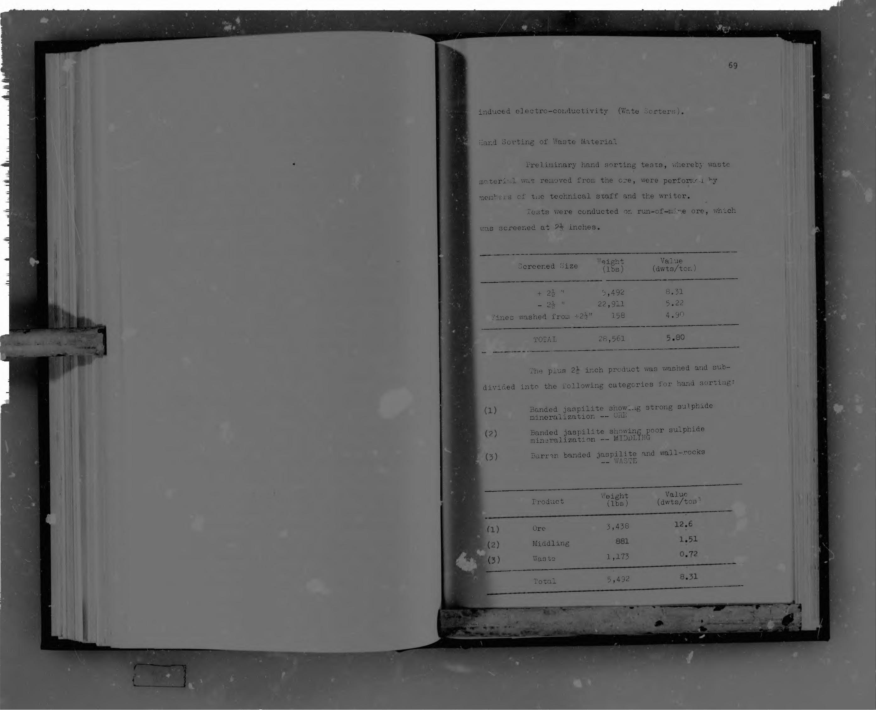
induced electro-conductivity (V/ate Sorters).
Hand Sorting of Waste Material
Preliminary hand sorting tesxs, whereby waste material was removed from the ore, were perforr.ru ^y members of tne technical sxaff and the writer.
Tests were conducted on run-of-mire ore, whichwas screened at inches.
ci , o • WeightScreened Size 'lbs' Value (dwts/ton)
+ 2& " D,492_ 2-i- " 22,911
Pines washed from +2- " 158
8.515.224.90
TOTAL 28,561
Weight (lbs)Product
5,458OreMiddlingWaste 1,175
5,492Total
The plus 2-g- inch product was washed and subdivided into the following categories for hand sorting-
Banded jaspilite showing strong sulphide mineralization — OREBanded jaspilite showing poor sulphide mineralization — MIDBLll 10-Barren banded jaspilite and wall-rocks
— WASTE
Value (dwts/ton '

induced electro-conductivity (V/ate Sorters),
Hand Sorting of Waste Material
Preliminary hand sorting tests, whereby waste m a te r ia l was removed from the ore, were performed by members of the technical staff and the writer.
Tests were conducted on run-of-mine ore, w was screened at 2| inches.
Screened Size Weight(lbs)
Value(dwts/ton)
+ 2* " 5,492 8.31- " 22,911 5.22
Pines washed from +2-|" 158 4.90
TOTAL 28,561 5.80
The plus 2^ inch product was washed and sub divided into the following categories for hand sorting.
(1 ) Banded jaspilite showing strong sulphidemineralization —
(2) Banded jaspilite showing poor sulphidemineralization — MIDDLIiTG
(3) Barren handed jaspilite and wall-rocksy _WASTE
W eigh t , Va lueProduct (lbs) (dwts/ton)
(1) Ore 3,438 12*6
(2) Middling 881 1!51-I ry-z 0,72(3 ) Waste 1,173
Total 5,492 8.31

The middling nd waste products together represent the total hand sorted waste material amounting to lb per cent of the total sample of run-of-mine ore tested. The o r ig in a l run-of-mine ore of 28,561 pounds averaging 5•80
pennyweights per ton minus the v/aste sorted becomes 26,50? pounds averaging 6.17 pennyweights per ton.
At present hand sorting of waste material on surface is the only form of ore benefioiation in operation on the Pickstone Mine, the washing and sorting taking place prior to the primary crushing.
Heavy Media Concentration
Heavy media concentration tests were carried out on Pickstone Mine ore by a firm of consulting engineers
in South Africa.Mean specific gravity tests conducted on the rock
types constituting the Pickstone Mine ore were as follows:
Rock Types Mean Specific Gra/it.
Mineralized banded ^jaspiliteBanded jaspilite 2.99Speckled chlorite ~schist (Wall-rock)
Heavy media concentration tests were carried out on Pickstone Mine ore using ferrc-silicon as medium. The following tabulation shows the mean resultsobtained by varying the specific gravity of th
silicon medium.

i I
TYPICAL laCOVBRIES OF CYCLONE SECTION
A. BASED ON AVERAGE RESULTS AT 3.15 SPECIFIC GRAVITY OF SEPARATION
HEAD PRODUCT (Sink) TAILS (Float)i . _ .- - ----- — i
ASSAY ’It. % Assay Recovery V: t. jo Assay Recovery |
5.28 143.41 ' 10.48 90.84% j51.13 1.0 9.16%
B. BASED l AVERAGE RESULTS AT 3.25 SPECIFIC GRAVITY OF SEPARATION
4.6 :30.20li1 15.4
i80.44% 169.79 •
1.82119,56%
5.8■ r ' ‘ ":34.64 12.54 76.87% j65.36 2.00 1 ^.13%
■A-,—
C. BASED ON AVERAGE RESET 3 AT 3.05 SPECIFIC GRAVITY F SEPARATION
9.40%54.79
7.80
TYPICAL REC VERIES OF SPIRALS. jDCTIjRi
BASED ON SPIRAI TESTS ON_z_J^@_+ 1 °
!5.25 19.45 18.00 75.24%
5.25 19.1 21.20 78.51%5.25 22.9
1 -----17.00 77.69%
80.5580.90
1.431.37
24.70% 21.49% 22.31%

The best result obtained for the cyclone section was with the medium having a specific gravity of separation of 3*15, the sink or up-graded ore being 46.41 per cent by w e ig h t with the float or waste being 51.13 per cent at the comparatively low value of 1.0 pennyweights per ton. I t
is interesting to note that the fines of the r piral section carried the high waste rating of approximately 80 per cent by weight, probably due to the high degree of splh. vering during blasting of the silica bands as opposed co the more compact sulphide-replaced siderite bands.
These tests were exceptionally promising, but the capital outlay for the installation of a heavy media plant designed to treat 50 tons per hour was considered to he too high for this size of mine.
Flotation
Members cf the 'technical staff conducted a series of flotation tests using a Unit Cell ' operates mooteffectively on pulp of a high densit- the purpose of these tests was to prove whether, a large percentage concentrate could be separated from a relatively coarse product (-10 mesh), and in so doing reduce the amount ofmaterial which would require fine-grinding. For vhese tests, samples were taken from the classifier underflow
and from the ball mill feed.In tests 7 and 8 the classifier underflow
sample was screened through 10 mesh screen and the plus
1 H mta cslo r'i-K»rtrh in +: c\ 1 ACBrdod .

Screen analysis of the whole sample used in bothtests •
+10 4.7%+35 33.8%+100 37.2%+200 11.0%+325 2.1%-325 11.2%
TEST 7A sample was conditioned for 5 minutes and two
concentrates of 3 minutes and 2 minutes taken#The reagents used v/ere as follows:
R301
Z6 - 0,08 lbs/tonCuS04 - 0.2b lbs/ton
Flotation tails Concentrate 1 Concentrate 2 Calculated Head Value Extraction Concentrates Moisture
TEST 8
- 0.12 lbs/ton i_-ie oil - 0.10 lbs/ton
7.63 dwts/ton 38.80 uwts/ton32.70 dwts/ton 10.30 dwts/ton
34.9%9.0%64.0%
The reagents used were as for Test 7 except that in place of the Pine oil, Dowfroth of 0.10 lbs/ton
was used.Flotation tails Concentrates 1 Concentrates 2 Calculated Head Value
Extraction ConcentratesMoisture
3,98 dwts/ton 70.90 dwts/ton38.40 dwts/ton10.80 dwts/ton
63.0#11.5#70.0#

This test was on a sample of Ball Mill feed, which was screened through 8 mesh and 14 mesh screens giving the following:
-4 + 8 mesh - 8T5 grams at 3.5 dwts/ton-8 + 14 mesh - 652 grams at 3.2 dwts/ton-14 mesh - 1063 gramsThe -14 mesh product was conditioned for 10
minutes with CuSO. (0.25 lbs/ton), then floated for 1 minute with Z6 (0.08 lbs/ton), B301 (0.16 lbs/ton), and Bov/forth (0.082 lbs/ton). Total flotation'time was 3 minutes. The concentrates were weighed and assayed, the tails graded and the fractions assayed.
Concentrates 138 grams at 23.4 dwts/ton Tails +35 381 grams at 2.8 dwts/ton
-HC j 208 grams at 1.6 dwts/ton+200 69 gratis at 0.45 dwts/ton-200 283 grams at 0.55 dwts/ton
Calculated Head Value on -14 mesh - 4.46 dwts/ton Calculated Taxi Value on -14 mesh - 1.68 dwts/ton Percentage extraction on -14 mesh - 62.3/It was proved from the numerous tests that were
carried out that the percentage extraction was too low and _ that extraction was almost negligable on the +35 mesn sizes.
Mineral Jigs
Members of the technical staff =or" e?h”“t3l,„(1epreliminary testa using a laboratory jig uhlcVg*™ pr&islr.

1 1 i ij A y<
75
Pickstone plant to take classifier underflow as a feed. After considerable teething problems jig tests were shown to give the f o' iowing approximate means:
Percentage concentrates - m-5% at 7.0 dwts/toa Tails concentrates - 55% at 1.7 dwts/ton
The tests were disappointing due to the high percentage of fines at high values, reporting in the relatively high percentage tails concentrates.
P neum atic Sorting (Wate Sorters)
This method of sorting is only descrioed ±tlgeneral as test figures are not available.
After primary inch crushing the ore was sizeddried, and passed over "he wate sorters. These wate sorters, using extremely high voltages, induce electro- conductivity through sulphide mineralized rocks that are passed between contacts, electronically triggering off pneumatic bias '' , which diverted the mineralized rocks
into separate collecting bins.

S :
BSSB: sWS:
76
Gold Outputs
A gold slime concentrate is produce i on the Pick- stone Mine and is transported to the Cam and Motor Mine plant for refining and the production of gold bars.Assay results showing the gold and silver fineness paeto- juji [iimnnnnrl) together with the calculated impurities are -Illustrated in graph form in Figures 14 and 15, covering the periods from 1957 to 1959, and from mid-1963 to mid- 1966 respectively. These graphs indicate that during certain periods of time the fineness of the gold fluctuated strongly while at other times it remained relatively steady. Furthermore, the fineness of the silver in these -old bars remained extremely steady at all times, leading to the conclusion that there is a direct inverse relationship between the gold and impurities present in those gold bars and that the variation in the fineness of the bullion produced is not due to significant variation in silver content. The impurities are thought to consist essentially of iron, which is present in the iron-rich sulphide , copper in the form of chalcopyrite usually as fillings m cracks and ..etween the interlocking boundries arsenopyrite and pyrlte, and minor amount- of niotea »hiohare detected as a &re©n staining on tne cupels tiur g
assaying*The ratios of the oxidised to suiphide ores
milled during these periods in which the fineness of the gold was either comparatively constant or fconsiderably, were calculated using the tonn g
TVies© ratiosfrom the oxidised and sulphide stapes.

Author Johnson R S Name of thesis The Geology of the Pickstone Gold Mine Hartley District Rhodesia 1967
PUBLISHER: University of the Witwatersrand, Johannesburg
©2013
LEGAL NOTICES:
Copyright Notice: All materials on the Un i ve r s i t y o f the Wi twa te r s rand , Johannesbu rg L ib ra ry website are protected by South African copyright law and may not be distributed, transmitted, displayed, or otherwise published in any format, without the prior written permission of the copyright owner.
Disclaimer and Terms of Use: Provided that you maintain all copyright and other notices contained therein, you may download material (one machine readable copy and one print copy per page) for your personal and/or educational non-commercial use only.
The University of the Witwatersrand, Johannesburg, is not responsible for any errors or omissions and excludes any and all liability for any errors in or omissions from the information on the Library website.


