34
Rising Sea Levels …At Our Doorstep June 2014 City and County of San Francisco Civil Grand Jury 2013-2014 City Hall 1 Dr. Carlton B. Goodlett Pl, San Francisco, CA 94102 Phone 415-554-6630
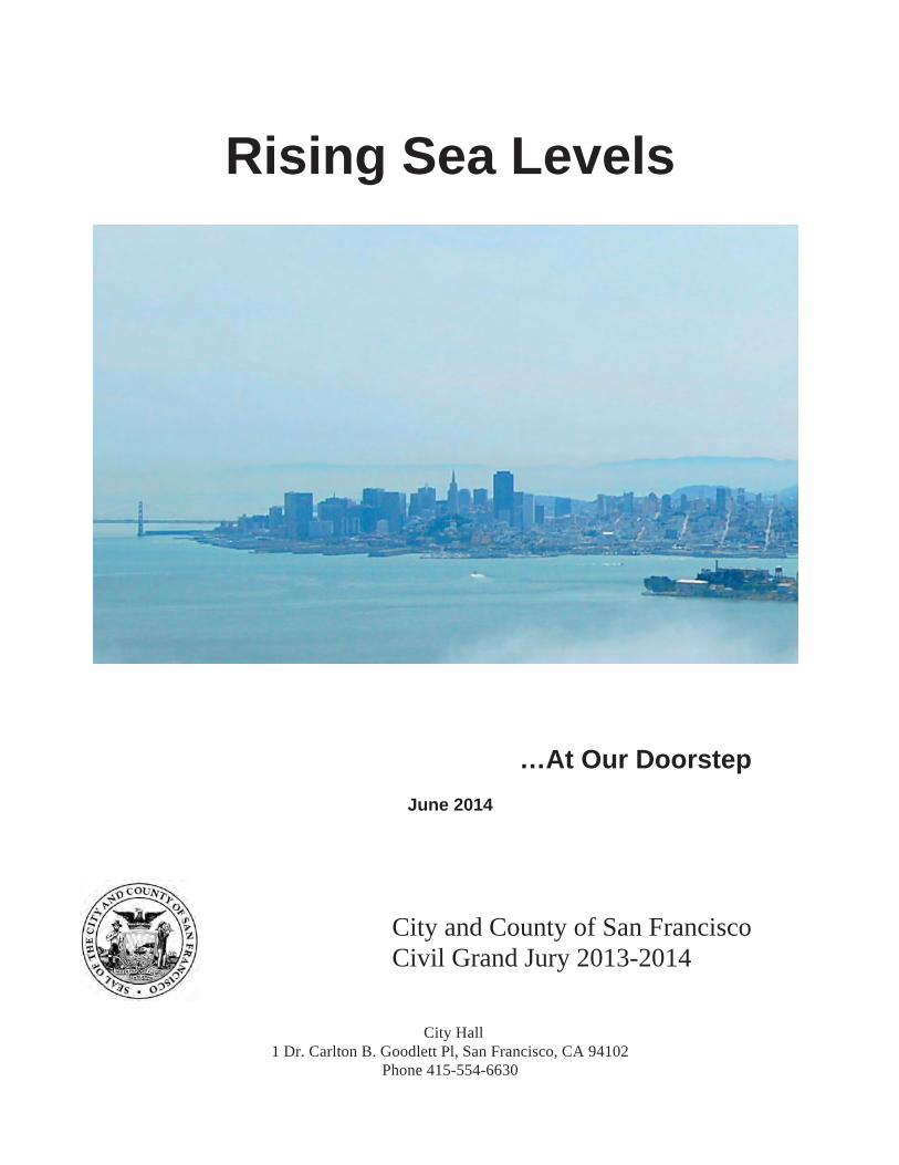
Rising Sea Levels
…At Our Doorstep
June 2014
City and County of San Francisco Civil Grand Jury 2013-2014
City Hall 1 Dr. Carlton B. Goodlett Pl, San Francisco, CA 94102
Phone 415-554-6630
ii
MEMBERS OF THE 2013-2014
CIVIL GRAND JURY
CITY AND COUNTY OF SAN FRANCISCO
Elena Schmid, Foreperson
Robert van Ravenswaay, Foreperson Pro Tem
Thomas Duda, Recording Secretary
Maryta Piazza, Corresponding Secretary
Larry Bush
Hans Carter
Daniel Chesir
Barbara Cohrssen
Mike Ege
John Finnick
Kai Forsley
Charles Head
David Hoiem
Joseph Kelly
Mazel Looney
Claudia O’Callaghan
Ernestine Patterson
Michael Skahill
iii
THE CIVIL GRAND JURY
The Civil Grand Jury is a government oversight panel of volunteers who serve for one year. It makes findings and recommendations resulting from its investigations.
Reports of the Civil Grand Jury do not identify individuals by name.
Disclosure of information about individuals interviewed by the jury is prohibited. California Penal Code, Section 929
STATE LAW REQUIREMENT California Penal Code, section 933.05
Each published report includes a list of those public entities that are required to respond to the Presiding Judge of the Superior Court within 60- to 90 days, as specified. A copy must be sent to the Board of Supervisors. All responses are made available to the public. For each finding the response must:
1) agree with the finding, or 2) disagree with it, wholly or partially, and explain why.
As to each recommendation the responding party must report that:
1) the recommendation has been implemented, with a summary explanation; or 2) the recommendation has not been implemented but will be within a set timeframe as
provided; or 3) the recommendation requires further analysis. The officer or agency head must define
what additional study is needed. The Grand Jury expects a progress report within six months; or
4) the recommendation will not be implemented because it is not warranted or reasonable, with an explanation.

iv
TABLE OF CONTENTS
Issue . . . . . . . . . . . . . . . . . . . . . . 1 Summary . . . . . . . . . . . . . . . . . . . . . 1 Background . . . . . . . . . . . . . . . . . . . . 2 Discussion . . . . . . . . . . . . . . . . . . . . . 2 Discussion of Specific Areas . . . . . . . . . . . . . 6 City Wastewater Plants . . . . . . . . . . . . . 6 Port of San Francisco Waterfront Area . . . . . . 6 San Francisco Airport (SFO) . . . . . . . . . . . 7 Treasure Island . . . . . . . . . . . . . . . . 8 Crissy Field . . . . . . . . . . . . . . . . . 8 Federal Concerns . . . . . . . . . . . . . . . 8 Findings and Recommendations . . . . . . . . . . . 9 Response Matrix . . . . . . . . . . . . . . . . . 15 Methodology . . . . . . . . . . . . . . . . . . . 22 Bibliography . , . . . . . . . . . . . . . . . . . 23 Appendices A. Sea Level Rise Projections . . . . . . . . . 26 B. Bay Area Map with Historical Shoreline . . . . 27 C. Map of SFO Vulnerabilities to Rising Sea Levels . 28 D. Map of SFO Shoreline Deficiencies by 2050 . . . 29 E. Treasure Island Adaptations to Rising Sea Levels 30
1
ISSUE
Rising seas levels: How and where will rising sea levels most likely affect the City of San Francisco and what is the City doing to address the issue.
SUMMARY
With each passing year the ocean and bay along the shores of San Francisco are continuing to rise. San Francisco, like other coastal cities around the world, faces a major flooding risk as a result of sea level rise. Because of global climate change, sea level rise is happening at an accelerated rate. The estimate for the San Francisco Bay area adopted by the State of California Coastal Commission, the San Francisco Bay Conservation and Development Commission (BCDC), and others is a gradual rise to 16 inches by 2050 and 55 inches by 2100. Unlike an earthquake, which happens suddenly and unexpectedly, sea level rise occurs gradually over time. However, the flood damage that can result can be just as damaging, especially when combined with storm surges, rainfall, high winds, high tides, and increased earthquake-induced liquefaction in areas of shoreline erosion. Is San Francisco aware of our future in this regard? Yes. Every department the Jury interviewed indicated they were keenly aware of the rising sea level threat. Are projects in vulnerable areas, such as the Port or the Mission Bay flood zone, considering rising seas in their building or restoration plans? Treasure Island, yes. Pier 70 project, yes, the Exploratorium at the Port, no. Is Ocean Beach proceeding with mitigation suggestions by an in-depth study? Not yet. Can anyone buying property today in a potential flood zone expect to see property values reduced by the end of a 30-year mortgage? We are currently at the cusp of the future in terms of sustainability. It took the Loma Prieta earthquake to awaken San Francisco to the necessity of intensified seismic retrofitting. Let’s not wait for a major flooding disaster, like Hurricane Sandy on the east coast, to start addressing the serious threat of rising sea levels. The threat is real; the time to act is now. For a start, San Francisco should, among other things, adopt a citywide comprehensive plan for adaptation to rising sea levels and amend the City’s Planning and Building Codes to include provisions addressing the impacts of sea level rise. Awareness is the beginning. Consistent plans, integrated into City policy, are vital. The following is the Jury’s look into San Francisco’s present and future regarding the inevitable rise of our seas.
2
BACKGROUND
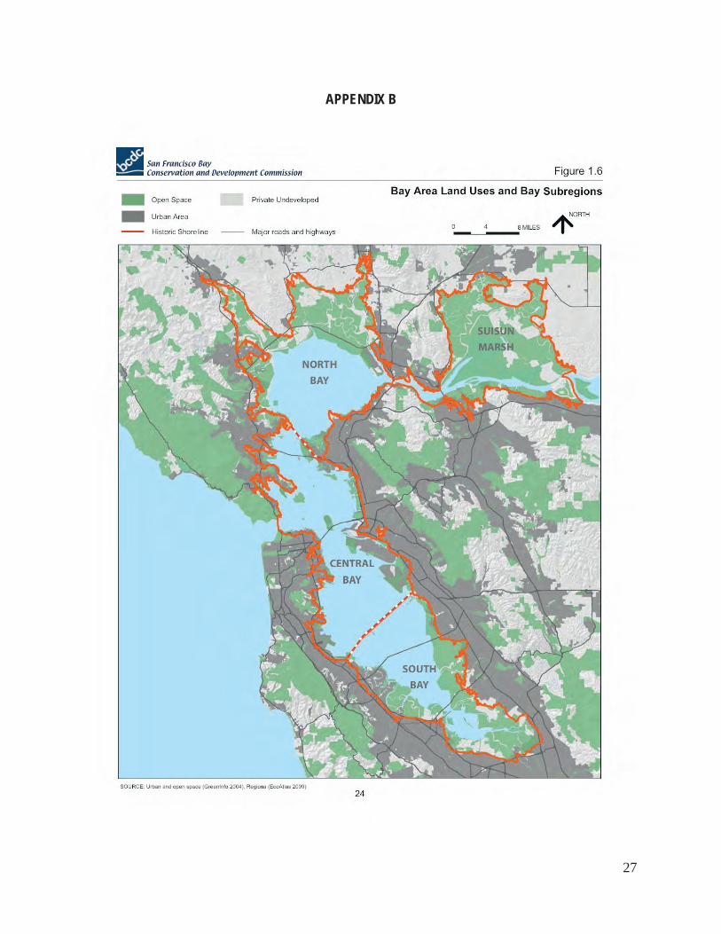
The Gold Rush left San Francisco Bay one-third its original size. The remaining two-thirds of the bay was filled to increase its height to just above sea level. This fill now supports our port buildings, piers, and residences (see Appendix B). Underground streams flow through a large area of the City, evidenced by their flooding above ground during heavy rainstorms. Mission Bay, a recognized flood plain, is currently a heavily developed area, with several future projects under consideration. Sea level rise has become a serious concern around the world, especially in coastal cities like San Francisco, New York, Boston, Sydney, London, Venice, Seattle, and Los Angeles, and it appears to be happening at an accelerated rate. Climate scientists attribute the acceleration to a number of factors, including thermal expansion and the meltdown of glaciers and the Greenland and West Antarctica ice sheets, all apparently caused by global warming. Higher sea levels can result in higher, stronger storm surges that can have a severe impact on coastal areas, including erosion, flooding, contamination of water sources, and damage to wastewater treatment plants.1 Accordingly, the Jury decided to investigate how and in what areas the City of San Francisco will most likely be affected by rising sea levels and what the City is doing to address the issue. In particular, our investigation focused on three inquiries: (1) whether the City is addressing the issue; (2) if so, what the City is doing now to address the issue; and (3) what the City should be doing now and in the near future to address the issue. The Jury’s concern for the future of San Francisco has prompted us to engage in this investigation. Much has been discovered to be commended and much to recommend.
DISCUSSION
Rising sea levels will be a dramatic and significant consequence of climate change in California. A tidal gauge by the Golden Gate Bridge has been measuring sea levels over the past century and indicates a rise of nearly 8 inches over that time. It will continue to rise as a result of thermal expansion of the oceans and an increase in ocean volume as land ice melts and runs off into the ocean. If development continues in areas at risk, all estimates of personal and property loss will rise. There are numerous reports on rising sea levels produced by scientists, governmental entities, and organizations on an international, national, state, and local level. These reports reiterate the science and the recommendations for individual communities. The following represent a composite of that information. The Third National Climate Assessment report was released in May 2014. The report states, 1See Melillo, Jerry M., Terese (T.C.) Richmond, and Gary W. Yohe, Eds., 2014: Climate Change Impacts in the United States: the Third National Climate Asseessment U.S. Global Change Research Program, 841 pp.doi:10.7930/JOZ31WJ2, Key Message 10: Sea Level rise, page 44; also see discussion in National Geographic, Rising Seas issue in its entirety, 9/13 and National Geographic article on sea level rise at http://ocean.nationalgeographic.com/ocean/critical-issues-sea-level-rise/ and Union of Concerned Scientists article on sea level rise at http://www.ucsusa.org/global_warming/science_and_impacts/impacts/causes-of-sea-level-rise.html
3
“Nearly 5 million people in the U.S. live within 4 feet of the local high-tide level (also known a mean higher high water). In the next several decades, storm surges and high tides could combine with sea level rise and land subsidence to further increase flooding in many of these regions.”2 According to John Englander, oceanographer, consultant, author of High Tide on Main Street, and founder of Sea Level Institute, “[a]s sea level rises, the shoreline will move far inland, since the average global shoreline movement is estimated at more than 300 feet for each foot of vertical change in sea level.”33 According to the City’s Department of Emergency Management report, San Francisco Hazard Mitigation Plan, December, 20084the following scenario will ensue: The rise of sea levels will affect the shoreline areas of the City, including Ocean Beach, the Marina, The Embarcadero, and the entire bayside edge, as well as parts of Treasure Island and flood plains; flooding from sea level rise will likely damage buildings and roads in these areas; salt water intrusion will likely cause damage to infrastructure, such as pipes and foundations; coastal flooding also presents a risk to major transportation infrastructure, especially at the Port of San Francisco and San Francisco International Airport (SFO). A study done by the Pacific Institute concludes that no matter what policies are implemented in the future, sea level rise will inevitably change the character of San Francisco Bay. This study recommends that future development and protection be governed by sustainability. Sustainability means “meeting the needs of the present without compromising the ability of future generations to meet their own needs.”5 The California Coastal Commission released its Draft Sea-Level Rise Policy Guidance in October 2013, which reports:
-The State is using National Research Council numbers of potential rise, which are: 1.5” to 12” by 2030, 4.5” to 24” by 2050, and 16.5” to 66” by 2100.
-The State will require the use of those measurements in planning. -Coastal Development Permits (CDP) will be necessary for future development. If no
time frame is provided in the application for a CDP, it will be considered to have a 75 to 100 year minimum project life.
-The CDP will include a site-specific analysis of how rising sea levels may constrain the project site.
-The Local Coastal Program (LCP) should require new development in potentially hazardous locations to include a waiver of the property owners’ right to shoreline protection or State assistance in the future.
-The report recommends maximizing protection of public access, recreation, and sensitive coastal resources (Coastal Act Chapter 3, Section 30235) ��Melillo, Jerry M., Terese (T.C.) Richmond. and Gary W. Yohe, Eds., 2014; Climate Change Impacts in the United States: the Third National Climate Assessment, U. S. Global Change Research Program, 841 pp. doi: 10.7930/JOZ31WJ2, Key Message 10: Sea Level Rise, page 44 ��John Englander’s blog, Sea Level Rise is Just Four Points, 10/31/13 ��An assessment of risks posed by natural and human-caused hazards and strategies for mitigation of those risks ����See Heberger, Matthew, Heater Cooley, Eli Moore, Pablo Herrera (Pacific Institute) 2012, The Impacts of Sea Level Rise on the San Francisco Bay, California Energy Commission Publication No. CEC=500-2012-014�
4
-The LCP should include an updated inventory and maps of all land uses, clearly showing areas vulnerable to sea level rise. The Ocean Beach Master Plan of May, 2012 is the combined effort of SPUR (San Francisco Planning and Urban Research Association) and its consultants, and involves the City of San Francisco, the State of California, the Army Corps of Engineers, and the National Park Service. It states: “Ocean Beach is 3.5 miles of beach and rugged coast from Cliff House to Fort Funston. For over 100 years, the ocean has been pushed seaward 200 feet from its natural equilibrium by roadways and development. There currently exists 10,000 feet of coastal armory (seawalls and boulders). Yet the storms of 2009-2010 caused its bluffs to recede 40 feet.” The plan provides that rather than staying in a reactionary mode, the time has come for the City to begin to put into place recommendations set forth in this plan, including, in part: (l) roadway reconfiguration near the zoo and at the south end of Ocean Beach; (2) reinforcement of the Lake Merced tunnel to control wastewater; (3) creation of a natural tidelands at the south end of Ocean Beach. Some work based on the plan's recommendations has already been put in place by PUC, DPW, and the Golden Gate National Recreation Area (GGNRA.) The Ocean Beach Master Plan does not have the force of law or policy. Nevertheless it provides a compelling case for enacting a long-term policy framework for Ocean Beach.
Bay Conservation and Development Commission (BCDC), formed to oversee bay development, dredging, and fill, under the State Public Trust Doctrine, has jurisdiction over the open water and marshes of greater San Francisco Bay, portions of most creeks, rivers, and other tributaries that flow into the bay, and100 feet landward of the mean high tide line. BCDC’s jurisdiction, however, is not stationary or fixed geographically, and it will change with an encroaching shoreline due to sea level rise. Since the law confers to BCDC jurisdiction over all areas that are subject to tidal action to mean high tide and areas within 100 feet landward of the mean high tide line, BCDC’s jurisdiction will necessarily extend landward as sea level rises. Currently, BCDC permits are presented for approval one at a time, which does not allow for the addressing of cumulative impact.
In October 2011, BCDC issued a report entitled, Living with a Rising Bay: Vulnerability and Adaptation in San Francisco Bay and on its Shoreline. This report addresses the potential viability of the Association of Bay Area Governments (ABAG) as a regional source of planning. ABAG includes not only BCDC, but the Metropolitan Transportation Commission, the Joint Policy Committee, and the Bay Area Air Quality Management District. According to this BCDC report, indirect effects of sea level rise are its salinity intrusion into groundwater and raising the water table along the shoreline and underground streams. An increased water table increases the risk of flooding by limiting the amount of precipitation that can infiltrate the ground. Also, a higher water table increases the risk of soil liquefaction during an earthquake (Holzer 2006)6. Further, the report advises governments to select appropriate responses for a specific site, prioritize them, and implement them over time. Considering limited resources, planning can be mainstreamed into existing planning efforts (Luers, 2007)7. Plans can be incorporated into routine repairs and maintenance projects without incurring additional costs. One suggestion involves clustered development, which would allow development in one area of a parcel. Under ��Holzer T.,et al 2006, “Predicted Liquefaction of East Bay Fills, etc., see Bibliography �� Luers, A.L., et al. “Our changing Climate”, etc., see Bibliography �
5
this strategy, development could be allowed in flood zones, but strategically located back from the shoreline or flood zone to provide space for that shoreline to move. The report also includes the reminder that the cost of modifying structures in their design stages is considerably less than the costs of reconstruction and flood damage. BCDC has a Rising Sea Levels working group of eight BCDC commissioners who met in July 2013 with Chevron, Union Pacific, Kaiser, PG&E, and SFO. In August 2013, they met with BART, Capitol Corridor Rail Service, East Bay Municipal Utility District (EBMUD), and the Port of Oakland. In October 2013, the group met with Bay Area Council, Bay Planning Coalition, Silicon Valley Leadership Group, East Bay Economic Development Alliance, and San Francisco Chamber of Commerce. They will be meeting next with the insurance industry. These meetings concern regional strategy for resilient shorelines. The Jury reviewed numerous public documents that address rising sea levels, issued by numerous City departments, including the Port, the Public Utilities Commission, the San Francisco Airport, and the Department of Environment, also known as SF Environment. The Jury talked to these agencies regarding rising sea levels and how they believed it would impact the City and what they were doing to adapt. All of these agencies agreed that rising sea levels is a real and serious threat that the City needs to address. In fact, an informal committee called, “SF Adapt”, was recently formed with a subcommittee dedicated to addressing the rising sea levels issue. The full committee includes a representative from each of the following City agencies: the Port, the Public Utilities Commission, the San Francisco Airport, the Department of Environment, the Planning Department, the Recreation and Park Department, the Office of the City Administrator, Municipal Transportation Agency (MTA), and the Department of Public Works (DPW). The Jury observed, however, that although there is no question this issue exists, the City has not yet produced a comprehensive plan for adaptation to rising sea levels. BCDC estimates that the sea level of San Francisco Bay will rise 16 inches by 2050 and 55 inches by 2100 (see Appendix A for a list of various sea level rise predictions). Flood damage resulting from rising sea levels can be especially severe when combined with storm surges and high tides. Neither the City’s Planning Code nor the City’s Building Inspection Code contains any provisions addressing BCDC’s sea level rise projections. Neither code insists that any construction project vulnerable to future shoreline flooding be designed to be resilient to at least the 2050 sea level rise projection. Nor do they provide a plan to address long-term rising sea level issues for construction projects intended to last beyond 2050. For example, rising sea levels was not taken into consideration for the Port’s renovation of the Pier 1 building or the Ferry Building or the recently completed Exploratorium construction. However, some proposed projects in the City do take rising sea levels into consideration in their design plans (see for example, the Treasure Island development and the Pier 70 construction project discussed below under Discussion of Specific Areas). A further example is the design process for the Port of Redwood City. Since their risk assessment revealed that sea level rise would be 1.53 feet by 2060 and there would be a 100-year flood level of +11.2 feet MLLW8 by 2060, it was decided to design adaptation measures for 12.7 �MLLW stands for mean low, low water:, which is the average of the lower of 2 low tides over a certain period of time. There are 2 low tides and 2 high tides daily.�
6
feet MLLW by 2060.
DISCUSSION OF SPECIFIC AREAS
City Wastewater Plants San Francisco has a combined sewer system that collects and treats both stormwater and wastewater effluent in the same system of sewer pipes. The system consists of large below-ground transport structures throughout the city that pump the sewage to wastewater treatment plants for treatment and eventual discharge into the bay and ocean. The City has three wastewater treatment plants: the Southeast Wastewater Treatment Plant in the Bayview district, which was built in 1952 and treats 80% of the City’s wastewater flow; the Oceanside Treatment Plant on the Great Highway near the San Francisco Zoo, which was built in 1993 and treats 20% of the City’s wastewater; and the North Point Weather Facility on Bay Street and The Embarcadero, which was built in 1951 and is only operated during wet weather to handle up to 150 million gallons per day of stormwater. These plants are particularly vulnerable to the effects of rising sea levels, as bay and ocean salt water will eventually flow into the wastewater collection systems, especially at high tide, thereby increasing the volume of wastewater requiring treatment and possibly causing flooding. Also, salt water intrusion kills the organisms that clean the wastewater and deteriorates the infrastructure of the plants. Salt water backflows have already infiltrated the City’s wastewater treatment plants, both bayside and oceanside, and sea level rise will increase the intensity of that intrusion. PUC has indicated in its Sewer System Master Plan and in other documents that backflow prevention devices and local pump stations should be installed to prevent backflow intrusion into the system. To the Jury’s knowledge, this has not yet been done. Port of San Francisco Waterfront Area Sea level rise presents a major threat to the 7.5 miles of the Port’s waterfront that stretches along the bay from the Hyde Street pier to the north to India Basin to the south. Seasonal king tides9 already overflow the City’s seawall, an occurrence that might happen more regularly as a result of rising sea levels. The Port currently has an unwritten, unofficial policy requiring all new construction projects to address rising sea levels in their design plans. One example is the proposed Pier 70 project, which involves, among other things, restoration and development of the historical buildings there and development of a commercial and residential area. The project has plans to elevate a building pad to 14.5 feet to withstand a projected extreme tide of 14.4 feet at the end of this century.
��High tides that occur when the gravitational pull of the sun and the moon are in alignment �
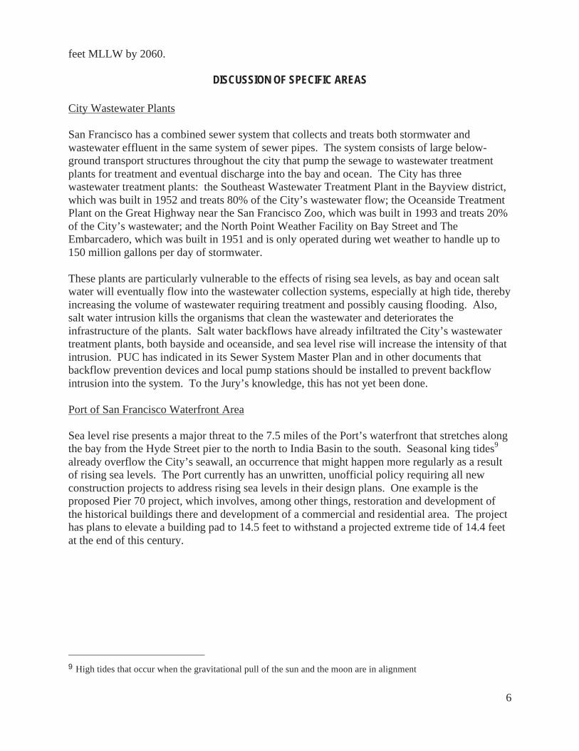
7
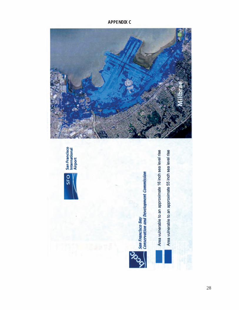
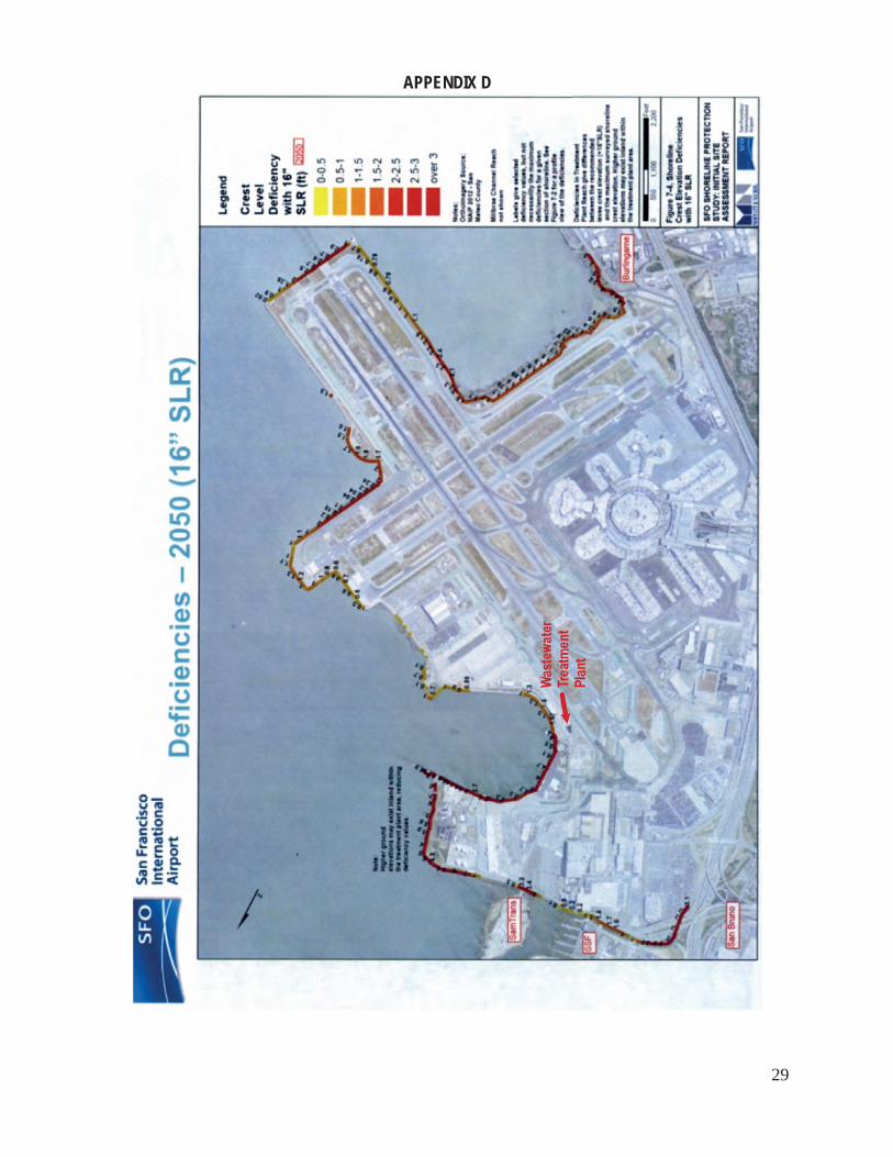
The Port’s shoreline presents unique challenges to rising sea levels. There is a section just south of the Ferry Building that frequently floods during winter storms. A winter, 2014 king tide estimated at 9 feet would have reached the surface level of many piers. Fortunately, that tide did not reach its potential and stopped at 7 feet. Many piers are old and decaying. The seawall runs under buildings, creating an accessibility problem. A Port consultant, URS Corporation, developed a map indicating the extent of inundation associated with a rise of 15 inches by 2050. (see Appendix B) The line of inundation closely resembles the shoreline of the bay prior to the Gold Rush San Francisco Airport (SFO) The average king tide from 1970 to 2012 was 9 feet. SFO is using as an adaptation guide the BCDC sea level rise projection of 16 inches by 2050 and 55 inches by 2100. SFO’s wastewater treatment plant, which is about 100 feet from the bay, has had some saltwater intrusion from storms. SFO has some seawall protection, but it was designed to protect only against high waves and does not protect against rising sea levels. San Francisco Airport (SFO) has a constant challenge in keeping its runways dry and safe for landings. During a rainstorm in February 2014, SFO was limited to one runway, postponing and canceling flights for several hours. Its wastewater plant and a City College of San Francisco school for mechanics sit on unprotected airport property north of the runways. Two creeks run landside of the airport to Highway 101. While natural tidelands would be an option for mitigation against rising seas, the consequential influx of birds would be a danger to air traffic. According to BCDC’s report of 10/6/11, Living with a Rising Bay, SFO would be 72% under
8
water with an increase of 16 inches and 93% under water with an increase of 55 inches (see Appendices C and D). It is interesting to note that permits for any potential work on airport property, including mitigation for rising sea levels, must be obtained from U.S. Fish and Wildlife, State Fish and Wildlife, Army Corps of Engineers, BCDC, State Coastal Conservancy, FAA, and the federal Environment Protection Agency. This is in contrast to the fewer number of permits required for other city properties. Treasure Island Treasure Island is undergoing a huge development project with a proposed production of up to 8,000 homes, extensive open spaces, hotels, restaurants, and retail. Appendix E shows Treasure Island project drawings of planned adaptive management strategies for protection against sea level rise. Treasure Island has a geology of bay clay, mud, and fill, not a promising foundation for its planned development. Its development plans, however, are an example of what can be done to mitigate encroaching sea water (see Appendix E). Mud will be dynamically compacted to solid fill to prevent liquefaction. Compaction will lower the level of the island by 30 inches. The ground level will then be raised with further compacted fill to 4 feet above current sea levels. Development will sit back from the shoreline 100 feet, which given current predictions of sea level rise, may or may not be sufficient. Plans are based on projections of a 16-inch rise by 2050 and 55 1/2-inch rise by 2100. There will be a commercial facility district for funding of sea walls. Crissy Field This area’s newly restored wetlands may serve a dual purpose, both as a natural habitat and as flood containment. Wetlands soil and vegetation will serve to slow encroaching waters. Federal Concerns The City is currently uninsured for flood damage under FEMA’s National Flood Insurance Program. The City does, however, maintain its umbrella membership in the program which allows private property owners to purchase FEMA insurance. For those properties insured under this program, funds are available to mitigate against future flooding. It would be interesting for the City to request a premium estimate from FEMA and then compare that estimate with the funding it could acquire from FEMA for such mitigation and adaptation Secretary of Housing and Urban Development, Shaun Donovan, states, “If we build smart, if we build resilience into communities, then we can live along the coast. We can do it in a way that saves lives and protects taxpayers.” 10 -----“San Francisco is more than a real estate opportunity. It’s a precious, special, fragile place.” Herb Caen ���At joint press conference with NYC Mayor Bloomberg in Brooklyn, NY, CBS/AP; 8/112/13
9
FINDINGS AND RECOMMENDATIONS
Comprehensive Plan Finding 1: The City does not have a citywide comprehensive plan that addresses the rising sea level issue. Recommendation 1a: The City should prepare and adopt a risk assessment in preparation for developing a comprehensive plan regarding the rising sea level issue. Recommendation 1b: The City should adopt a citywide comprehensive plan for adaptation to rising sea levels, especially along its shores and its floodplains, which should include a provision that the plan be reviewed and reassessed every five years. The plan should include the provision that construction projects approval should take into account the anticipated lifespan of each project and the risks faced as outlined in said plan. Special consideration should be given to those anticipated to survive for more than thirty years. Recommendation 1c: The City should build infrastructure systems that are resilient and adaptable to rising sea levels. The City, through its planning and building departments, should require that any construction project vulnerable to future shoreline or floodplain flooding be designed to be resilient to sea level rise at the 2050 projection, e.g., 16 inches, if the construction is not expected to last longer than 2050. For construction intended to last longer than 2050, it is recommended that the City require that the project be designed to address sea level rise projections for the longer term. Recommendation 1d: The City departments that would necessarily be involved in adaptation to rising sea levels, such as Department of Public Works. Public Utilities Commission, Municipal Transportation Agency, the Port, should coordinate their projects with each other and with utility companies, such as PG&E, Comcast, and AT&T, to minimize inconvenience to the public, and to businesses, and further to avoid repetition of efforts and inefficient use of funds, labor, and time.
10
Planning Code and Building Code Finding 2: The City’s Planning Code has no provisions addressing the impacts associated with rising sea levels. Without appropriate provisions within the City’s Planning Code, there are no effective means to insure sustainable development on land vulnerable to rising sea levels. Recommendation 2a: The City should amend its Planning Code to include maps showing the areas in the City that are most at risk from the impacts of sea level rise. The Planning Code should be amended to prohibit development in said at-risk areas unless there is compliance with the provisions of the City’s Building Code and the Port’s Building Code (if applicable to the project) outlined in Recommendation 3 below. The amendment should include a provision that the amended sections of the Code regarding the impact of rising sea levels be reviewed and reassessed every five years. Recommendation 2b: The Planning Code should be amended to discourage permanent development in at-risk areas where public safety cannot be protected regarding the impact of rising sea levels. Finding 3: The City’s Building Code and the Port’s Building Code have no provisions addressing the impacts associated with rising sea levels. Without appropriate provisions within the City’s Building Code and the Port’s Building Code, there are no effective means to control construction methods that would insure a project’s resistance to the impacts of rising sea levels. Recommendation 3: The City’s Building Code and the Port’s Building Code should be amended to include: (l) provisions addressing the impacts associated with sea level rise, especially when combined with sudden storm surges and king tides, (2) construction methods that would ensure a project’s resistance to and protection from the impacts of rising sea levels, especially when combined with sudden storm surges and king tides; (3) amendments written to protect the most vulnerable systems, including but not necessarily limited to, electrical, telecommunications, and fire protection systems; (4) a provision that the sections of the Codes regarding the impact of rising sea levels should be reviewed and reassessed every five years.
11
Finding 4: BCDC has the final say on any permit within its jurisdiction. Recommendation 4: The City should consult with BCDC at the onset of development plans within BCDC’s jurisdiction to ensure equitable and efficient results without necessitating surplus expenditures and time. Ocean Beach Master Plan Finding 5: A comprehensive risk assessment of Ocean Beach, with mitigation recommendations made to the City regarding rising sea levels, was completed by SPUR, with City, State of California and U.S Corps of Engineers involvement, resulting in the Ocean Beach Master Plan, dated May, 2012. Recommendation 5: The City should consider implementation of recommendations that are most pertinent to the City set forth in the Ocean Beach Master Plan, May 2012. Public Utilities Commission Finding 6: A number of measures can be taken now by the Public Utilities Commission to minimize the impact of sea level rise, especially when combined with future king tides and sudden surges. Recommendation 6: The City should build, through the Public Utilities Commission, larger sewer pumps, sewer pipes, and sewer transport storage boxes surrounding the city in the near future to accommodate king tides, sudden surges, and sea level rise. Finding 7: Salt water backflows have already infiltrated the City’s wastewater treatment plants, both in the Bayside and Oceanside plants. Salt water kills organisms in the system that clean wastewater and damages wastewater treatment equipment. As a result of sea level rise, bay and ocean saltwater backflow into the wastewater treatment systems will dramatically increase, causing serious problems for the wastewater treatment processes. Recommendation 7: The City should, as an interim measure, retrofit outfalls in the wastewater treatment system with backflow prevention devices to prevent salt water intrusion into the collection systems resulting
12
from high tides, sudden surges, and rising sea level. Local pump stations should also be installed to raise the flow to sewer discharge structures with higher elevations. Finding 8: The Southeast Wastewater Treatment Plant (Bayside), built in 1952, is aging and needs restoration. Recommendation 8: The City should retrofit the Southeast Wastewater Treatment Plant to accommodate future king tides, sudden surges, and sea level rise. San Francisco Airport Finding 9: The San Francisco Airport (SFO) is located slightly above sea level and therefore vulnerable to flooding from heavy rainfall, king tides, and rising sea levels. A number of measures can be taken now by SFO to minimize the impact of sea level rise, especially when combined with future king tides and sudden surges. Recommendation 9a: SFO should increase the height of its existing seawalls along its runways to accommodate rising sea levels. Recommendation 9b: SFO should continue to improve measures to eliminate standing water on its runways to ensure they remain sufficiently above sea level. Recommendation 9c: The northern section of SFO should be analyzed by airport engineers to determine how best to protect its wastewater treatment plant and other infrastructure in that section from sea level rise (e.g. construction of sea walls). The Port of San Francisco Finding 10: The Port of San Francisco is built on landfill, and its seawall lies beneath many buildings along the bay. Many piers are in poor condition. A number of measures can be taken now by the Port to minimize the impact of sea level rise, especially when combined with future king tides and sudden surges.
13
Recommendation 10a: The Port should begin planning and create a timeline for construction of flood control barriers in the low spots along the edges of the piers to prevent waterfront flooding associated with sea level rise. Recommendation 10b: To assist with the cost of protective measures to address sea level rise, the Port Commission should establish a reserve fund as part of its leasing policy whereby a surcharge is assessed as part of the rent or as a separate line item in each lease. City Adaptation Funds Finding 11: The City has not set aside funds for the cost of adaptation to sea level rise. Recommendation 11a: The City should start a reserve fund for adaptation for rising sea levels, a portion of which could be obtained from a surcharge on development planned for areas vulnerable to said eventuality. Recommendation 11b: The City should assess costs of both implementation of adaptation strategies and potential losses from failing to do so. Recommendation 11c: The City should explore applying for grants offered by Congress’ Pre-Disaster Mitigation Program. Receipt of grants is based upon risk assessments indicating that potential savings would exceed the cost of implementation. The City should explore available matching funds from the Army Corps of Engineers and other federal sources. Recommendation 11d: The City should request an insurance premium estimate from FEMA and then compare that estimate with the funding it could acquire from FEMA for mitigation and adaptation against future flooding.
14
Regional Issues Finding 12: Rising sea levels is a regional problem. What one community does to protect its shorelines may have a negative impact on a neighboring community. Recommendation 12a: The City should, through its Mayor and Board of Supervisors, coordinate its efforts with other cities and organizations in the bay area by establishing a working group to address the impact of rising sea levels. This has been successfully accomplished by four counties on the east coast of Florida, as an example. Recommendation 12b: That the City create a local working group of community citizens and stakeholders to feed into the regional group.
15
RESPONSE MATRIX
FINDINGS
RECOMMENDATIONS RESPONSE REQUIRED
Comprehensive Plan Finding 1 The City does not have a citywide comprehensive plan that addresses the rising sea level issue.
Recommendation 1a The City should prepare and adopt a risk assessment in preparation for developing its comprehensive plan regarding the rising sea level issue Recommendation 1b The City should adopt a citywide comprehensive plan for adaptation to rising sea levels, especially along its shores and its floodplains. Said plan should include the provision that construction projects’ approval should take into account the anticipated lifespan of each project and the risks faced as outlined in said plan. Special consideration should be given to those anticipated to survive for more than 30 years. Said plan should include a provision that the plan be reviewed and reassessed every 5 years. Recommendation 1c: The City should build infrastructure systems that are resilient and adaptable to rising sea levels. That the City, through its planning and building departments, require that any construction project vulnerable to future shoreline or floodplain flooding be designed to be resilient to sea level rise at the 2050 projection, e.g., 16 inches if the construction is not expected to last longer than 2050. For construction intended to last longer than 2050, that the City require that the project be designed to address sea level rise projections for the longer term.
Mayor or Mayor’s Designated Agency Board of Supervisors DPW Dept. of Environment Dept. of Emergency Management Planning Port PUC
16
FINDINGS
RECOMMENDATIONS RESPONSE REQUIRED
Recommendation 1d: That City departments that would necessarily be involved in adaptation to rising sea levels, such as Department of Public Works, Public Utilities Commission, Municipal Transportation Agency, the Port, coordinate their projects with each other and with utility companies, such as PG&E, Comcast, and AT&T, to minimize inconvenience to the public, and to businesses, and to further avoid repetition of efforts and inefficient use of funds, labor, and time.
Planning Code and Building Code Finding 2: The City’s Planning Code has no provisions addressing the impacts associated with rising sea levels. Without appropriate provisions within the City’s Planning Code, there are no effective means to insure sustainable development on land vulnerable to rising sea levels.
Recommendation 2a: The Planning Code should be amended to include maps showing the areas in the City that are most at risk from the impacts of sea level rise. The Planning Code should be amended to prohibit development in said at-risk areas unless there is compliance with the provisions of the City’s Building Code and the Port’s Building Code (if applicable to the project) outlined in Recommendations 3a and 3b. The Planning Code should include a provision that the amended sections of the Code regarding the impact of rising sea levels be reviewed and reassessed every 5 years.
Board of Supervisors Planning
Recommendation 2b: The Planning Code should be amended to discourage permanent development in at risk areas where public safety cannot be protected.
Finding 3: The City’s Building Code and the Port’s Building Code have no provisions
Recommendation 3: The City’s Building Code and the Port’s Building Code should be amended to include:
Board of Supervisors DBI Planning Port
17
FINDINGS
RECOMMENDATIONS RESPONSE REQUIRED
addressing the impacts associated with rising sea levels. Without appropriate provisions within the city’s Building Code and the Port’s Building Code, there are no effective means to control construction methods that would insure a project’s resistance to the impacts of rising sea levels.
(1) provisions addressing the impacts associated with sea level rise, especially when combined with storm surges and king tides; (2) construction methods that would ensure a project’s resistance to and protection from the impacts of rising sea levels, especially when combined with sudden storm surges and king tides; (3) amendments written to protect the most vulnerable systems, including but not necessarily limited to, electrical, telecommunications, and fire protection systems; (4) provisions relating to rising sea levels be reviewed and reassessed every five years.
Finding 4: BCDC has the final say on any permit within its jurisdiction.
Recommendation 4: The City should consult with BCDC at the onset of development plans within BCDC’s jurisdiction to ensure equitable and efficient results without necessitating surplus expenditures and time.
Mayor Planning Port
Ocean Beach Master Plan Finding 5: A comprehensive risk assessment of Ocean Beach, with mitigation recommendations made to the City regarding rising sea levels, was completed by SPUR, with City, State of California and U.S Corps of Engineers involvement, resulting in the Ocean Beach Master Plan, dated May, 2012.
Recommendation 5: The City should consider implementation of recommendations that are most pertinent to the City, as set forth in the Ocean Beach Master Plan of May 2012.
Mayor or Mayor’s Designated Agency Board of Supervisors
18
FINDINGS
RECOMMENDATIONS RESPONSE REQUIRED
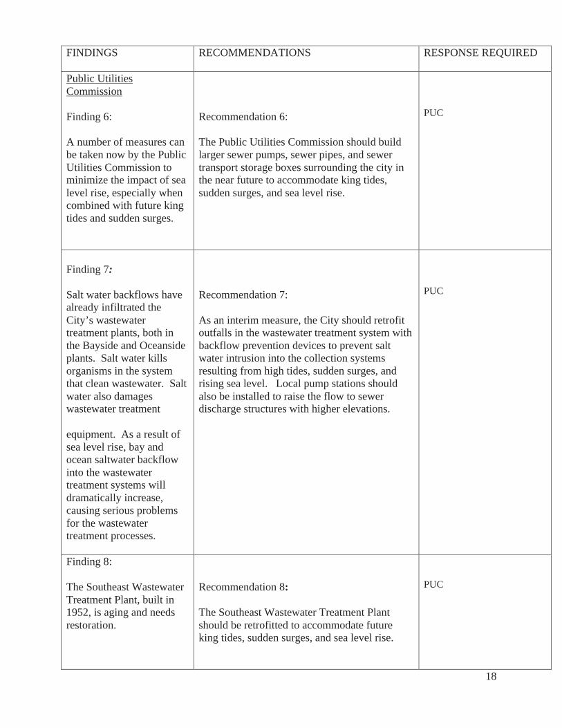
Public Utilities Commission Finding 6: A number of measures can be taken now by the Public Utilities Commission to minimize the impact of sea level rise, especially when combined with future king tides and sudden surges.
Recommendation 6: The Public Utilities Commission should build larger sewer pumps, sewer pipes, and sewer transport storage boxes surrounding the city in the near future to accommodate king tides, sudden surges, and sea level rise.
PUC
Finding 7: Salt water backflows have already infiltrated the City’s wastewater treatment plants, both in the Bayside and Oceanside plants. Salt water kills organisms in the system that clean wastewater. Salt water also damages wastewater treatment equipment. As a result of sea level rise, bay and ocean saltwater backflow into the wastewater treatment systems will dramatically increase, causing serious problems for the wastewater treatment processes.
Recommendation 7: As an interim measure, the City should retrofit outfalls in the wastewater treatment system with backflow prevention devices to prevent salt water intrusion into the collection systems resulting from high tides, sudden surges, and rising sea level. Local pump stations should also be installed to raise the flow to sewer discharge structures with higher elevations.
PUC
Finding 8: The Southeast Wastewater Treatment Plant, built in 1952, is aging and needs restoration.
Recommendation 8: The Southeast Wastewater Treatment Plant should be retrofitted to accommodate future king tides, sudden surges, and sea level rise.
PUC
19
FINDINGS
RECOMMENDATIONS RESPONSE REQUIRED
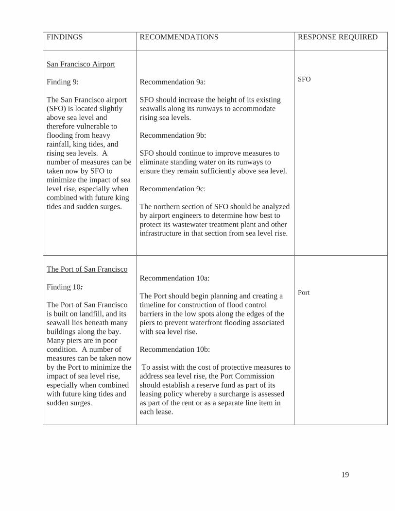
San Francisco Airport Finding 9: The San Francisco airport (SFO) is located slightly above sea level and therefore vulnerable to flooding from heavy rainfall, king tides, and rising sea levels. A number of measures can be taken now by SFO to minimize the impact of sea level rise, especially when combined with future king tides and sudden surges.
Recommendation 9a: SFO should increase the height of its existing seawalls along its runways to accommodate rising sea levels. Recommendation 9b: SFO should continue to improve measures to eliminate standing water on its runways to ensure they remain sufficiently above sea level. Recommendation 9c: The northern section of SFO should be analyzed by airport engineers to determine how best to protect its wastewater treatment plant and other infrastructure in that section from sea level rise.
SFO
The Port of San Francisco Finding 10: The Port of San Francisco is built on landfill, and its seawall lies beneath many buildings along the bay. Many piers are in poor condition. A number of measures can be taken now by the Port to minimize the impact of sea level rise, especially when combined with future king tides and sudden surges.
Recommendation 10a: The Port should begin planning and creating a timeline for construction of flood control barriers in the low spots along the edges of the piers to prevent waterfront flooding associated with sea level rise. Recommendation 10b: To assist with the cost of protective measures to address sea level rise, the Port Commission should establish a reserve fund as part of its leasing policy whereby a surcharge is assessed as part of the rent or as a separate line item in each lease.
Port
20
FINDINGS
RECOMMENDATIONS RESPONSE REQUIRED
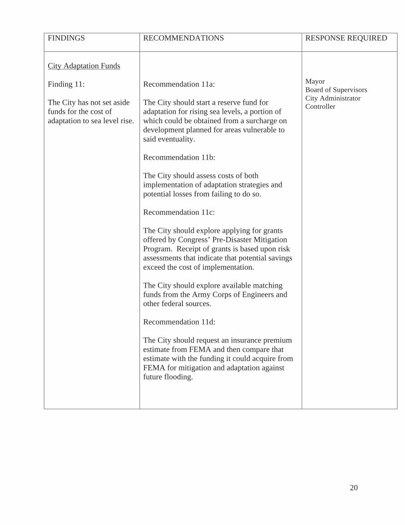
City Adaptation Funds Finding 11: The City has not set aside funds for the cost of adaptation to sea level rise.
Recommendation 11a: The City should start a reserve fund for adaptation for rising sea levels, a portion of which could be obtained from a surcharge on development planned for areas vulnerable to said eventuality. Recommendation 11b: The City should assess costs of both implementation of adaptation strategies and potential losses from failing to do so. Recommendation 11c: The City should explore applying for grants offered by Congress’ Pre-Disaster Mitigation Program. Receipt of grants is based upon risk assessments that indicate that potential savings exceed the cost of implementation. The City should explore available matching funds from the Army Corps of Engineers and other federal sources. Recommendation 11d: The City should request an insurance premium estimate from FEMA and then compare that estimate with the funding it could acquire from FEMA for mitigation and adaptation against future flooding.
Mayor Board of Supervisors City Administrator Controller
21
FINDINGS
RECOMMENDATIONS RESPONSE REQUIRED
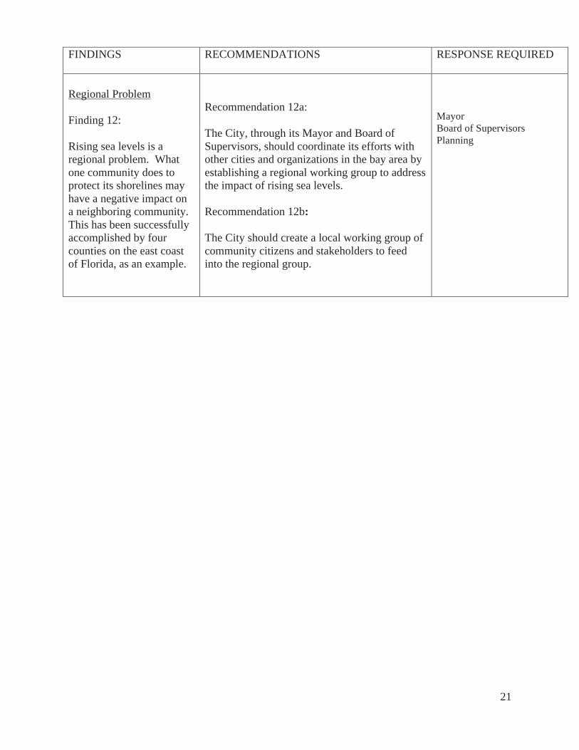
Regional Problem Finding 12: Rising sea levels is a regional problem. What one community does to protect its shorelines may have a negative impact on a neighboring community. This has been successfully accomplished by four counties on the east coast of Florida, as an example.
Recommendation 12a: The City, through its Mayor and Board of Supervisors, should coordinate its efforts with other cities and organizations in the bay area by establishing a regional working group to address the impact of rising sea levels. Recommendation 12b: The City should create a local working group of community citizens and stakeholders to feed into the regional group.
Mayor Board of Supervisors Planning
22
METHODOLOGY
The Jury conducted over a dozen interviews of personnel of City agencies and non-City agencies and reviewed numerous documents issued by these agencies to determine what the City is doing to address rising sea levels. Numerous scientific reports and studies regarding global climate change and sea level rise were reviewed, including those listed in this report’s bibliography. The Jury also attended a number of panel discussions on the issue and took personal tours of SFO, the Oceanside Wastewater Treatment Plant, Ocean Beach, Treasure Island, the Port piers, and adjacent areas along the Port waterfront.
23
BIBLIOGRAPHY
Barthalomew, Brendan P., “Officials Weigh Options for Protecting SFO, Other Airports, from Sea Level Rise”, The Examiner, 10/4/13 Barthalomew, Brendan P., “Committees: Time for Bay Area to Begin Addressing Risks Posed by Sea Level Rise”, The Examiner, 1/24/14 Burton Act of 1969, AB 2649, gives Port of San Francisco jurisdiction of state-controlled tidal lands California Climate Action Team (CO-CAT), “Sea-Level Rise Guidance Document”, 3/13 California Coastal Commission, “Draft Sea-Level Rise Police Guidance”, 10/13 California Energy Commission, Climate Change Center, The Impacts of Sea-Level Rise on the California Coast”, 5/09 California Lands Commission, “Public Trust Doctrine of 1969”, instituted for protection of shorelines California “Tidelands Act of 1880”, original protection of bay shores for railroads, now superceded Commonwealth Club, San Francisco, panels and speakers on podcasts re Climate One Calthorpe, Peter, “Levees around SF?”, 5/15/11 Englander, John “Bracing for Impact”, 3/18/13 Nutter, Melanie, R. Z. Wasserrman, Ezra Rapport, panel on Rising Sea Levels, 3/20/13 Panel discussion, “Bracing for Impact”, 3/18/13 Connecticut Office of Legislative Research, “Sea Level Rise Adaptation Policy in Various States”, 10/28/12 Donovan, Shaun, Secretary of Housing and Urban Development, at a joint press conference with NYC Mayor Michael Bloomberg in Brooklyn, NY, CBS/AP, August 12, 2013 Englander, John, founder of Sea Level Institute, oceanographer, consultant, author, High Tide on Main Street, and blog, 2/14 FEMA’s National Flood Insurance Program Fimrite, Peter, “Oyster revival in bay now 2 million strong”, San Francisco Chronicle, 11/15/13 Forseth, Patrick, “Adaptation to Sea Level Rise in Metro Vancouver”, 2/20/12 Gresham, Zane and Imwalle, Miles, “Sea Level Rise Regulatory Responses in San Francisco Bay and Across the Globe”, originally published by the American Bar Association, appears in
24
Trends, Volume 43, No. 3, January/February, 2012 Gillis, Justin, “Timing a Rise in Sea Level”, New York Times, 8/13/13 Governmental Panel on Climate Change (IPCC), report of 9/27/13 Heberger, Matthew, Cooley Heater, Eli Moore, Pablo Herrera of Pacific Institute, “the Impacts of Sea Level rise on the San Francisco Bay”, California Energy Commission Publication No CEC-500-1021-014 Hertsgaard, Mark, HOT: Living Through the Next Fifty Years on Earth, Houghton Miffin Harcourt, 2011 Holzer, T., J Blair, T Noce, M. Bennett, “Predicted Liquefaction of East Bay Fills during a Repeat of th 1906 San Francisco Earthquake, Earthquake spectra, Volume 22, No. S2, PP. S226-S277, 4/06 ICLEI – Local Governments for Sustainability, “Sea Level Rise Adaptation strategy for San Diego Bay”, 1/12 Laird, John, “King Tides, a Preview of Coming Sea Rise”, San Francisco Chronicle, 12/24/13 Laird, John, “It’s Time to Prepare for Rising Sea Levels”, San Francisco Chronicle, 12/25/13 Lamb, Jonah Owen, “Gray Sunset may be Going Green”, San Francisco Chronicle, 12/5/13 Little Hoover Commission, minutes of testimony from BCDC, 10/24/13 Lochhead, Carolyn, “Ecologists try in quiet ways to save planet”, San Francisco Chronicle, 1/5/14 Luers, A.L., D. R. Cayan, G. Franco, M. Hanemann, B. Croes, “Our Changing Climate: Assessing the risks to California”, a summary report from the California Climate Change Center, sponsored by the California Energy Commission and the California Environmental Protection Agency, Sacramento, CA, CEC-500-2006-077 Melillo, Jerry M., Terese (T,.C.) Richmond, and Gary W. Yohe, Eds., 2014; Climate Change Impacts in the United States: The Third National Climate Assessment, U.S. Global Change Research Program, 841, pp. doi:10.7930/JOZ31WJ2, Key Message 10: Sea Level rise, page 44 Moss, R. H., G. A . Moehl, M. C. Lamos, J. B. Smith, J. R. Arnold, J. C. Arnott, D. Behar, G. P. Brasseur, S. B. Bronnell, A. J. Busallacchi, S. Dessai, K. L. Ehi, J. A. Edmonds, J. Furlow, L. Goddard, .H. C. Hartman, J. W. Hurrell, J. .W. Katzenberger, D. M. Liverman, P, W . Mote, S. C. Moser, A. Kunar, R. S Pulwarty, E. A. Seyller, B. L. Turrner II, W. M. Washington, J. T.Wilbanks, “Hell and High Water Practice-Relevant Adaptation Science,”, Science magazine, 1l/8/13 National Geographic, Rising Seas issue in its entirety, 9/13
25
Pender, Kathleen, “Backlash over Changes in U.S. Flood Insurance”, San Francisco Chronicle, 11/17/13 Petroski, Henry, “The Stormy Politics of Building”, New York Times, 10/23/13 “Plan NYC: A Stronger, More Resilient New York”, 2/11/13 San Francisco Bay Conservation and Development Commission (BCDC), “Climate Change Hits Home”, report of 5/11 San Francisco SPUR, “Ocean Beach Master Plan”, 5/12 San Francisco BCDC “Rising Sea Levels” panel ,discussion 2/16/14 San Francisco BCDC, “SF Bay: Preparing for the Next Level”, 9/22/09 San Francisco BCDC, “Living with a Rising Bay: Vulnerability-Adaption in San Francisco and on its Shoreline”, 10/6/11 San Francisco Building Code “San Francisco Draft Hazard Miitigation Plan”, 2014 San Francisco Planning Code San Francisco Port Commission, meeting minutes of 9/24/13 Schlesinger, Victoria, “Uncertain about Rising Seas, Developers Using Mid-range Estimate to Build up Island”, San Francisco Public Press, 6/29/10 “Senate Committee Upholds Bay Protections”, Sierra Club Yodeler, August-September, 2013 “Sewer System Improvement Project (SSIP)”, San Francisco Public Utilities Commission (PUC), 8/28/12 Shorto, Russell K., “How to Think Like the Dutch in a Post-Sandy World”, New York Times, 4/9/10 Temple, James , “How Climate-Change Deniers Misuse Global Warming Data”, San Francisco Chronicle, 7/12/13 “Treasure Island Infrastructure Plan”, 6/28/11 “Warrior’s Project and the Public Trust”, Sierra Club Yodeler, June-July, 2013 U.S. Geological Survey. Scientific study for California Energy Commission, “State Potential Inundation due to Rising Sea Levels in the SF Bay Region”, 3/09 White, Richard, “Flouting the Rules Harms Us”, San Francisco Chronicle, 9/23/13
26
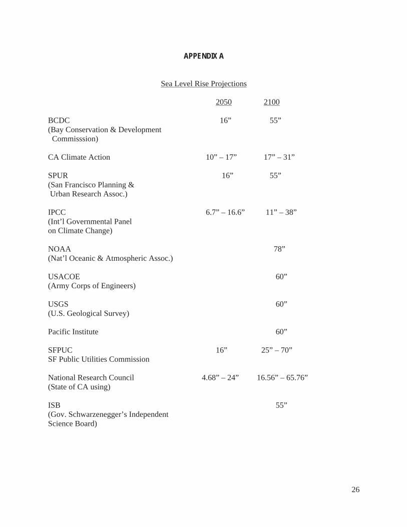
APPENDIX A
Sea Level Rise Projections
2050 2100 BCDC 16” 55” (Bay Conservation & Development Commisssion) CA Climate Action 10” – 17” 17” – 31” SPUR 16” 55” (San Francisco Planning & Urban Research Assoc.) IPCC 6.7” – 16.6” 11” – 38” (Int’l Governmental Panel on Climate Change) NOAA 78” (Nat’l Oceanic & Atmospheric Assoc.) USACOE 60” (Army Corps of Engineers) USGS 60” (U.S. Geological Survey) Pacific Institute 60” SFPUC 16” 25” – 70” SF Public Utilities Commission National Research Council 4.68” – 24” 16.56” – 65.76” (State of CA using) ISB 55” (Gov. Schwarzenegger’s Independent Science Board)
27
APPENDIX B
28
APPENDIX C
29
APPENDIX D
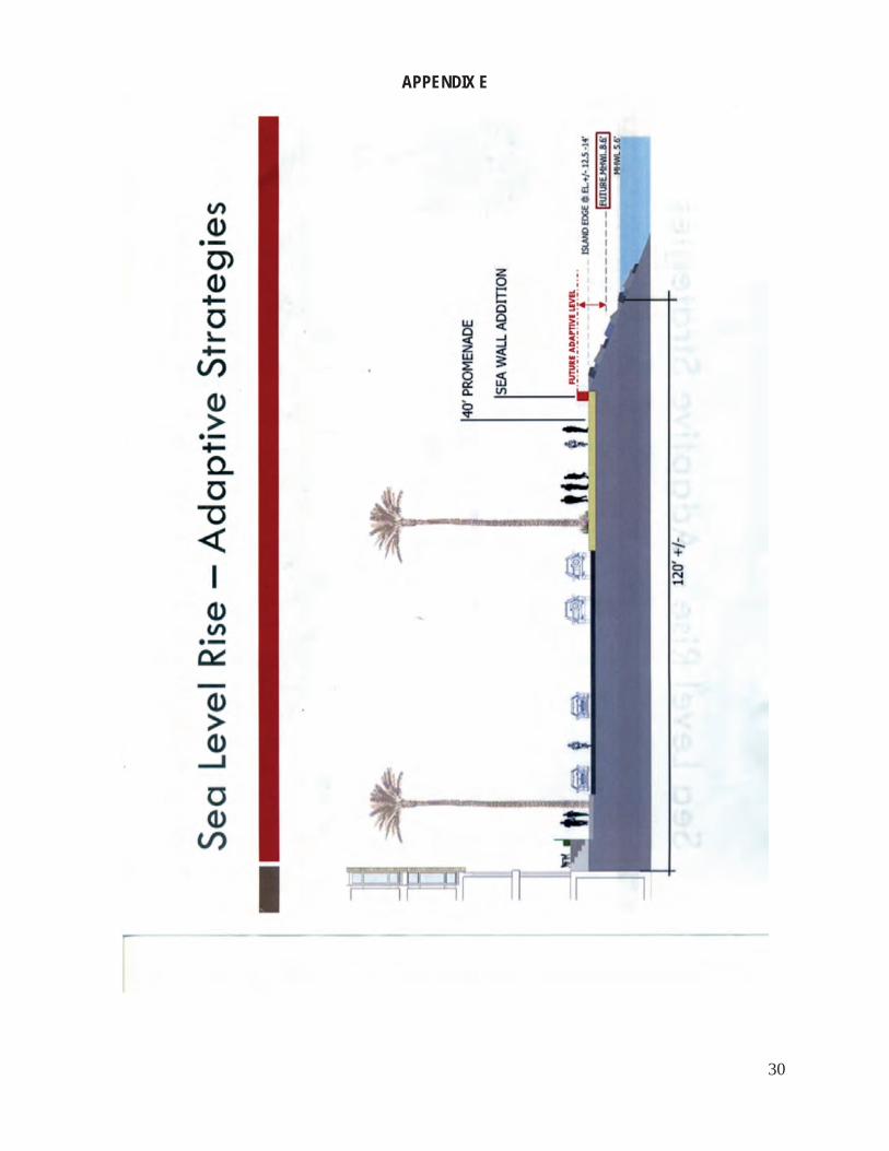
30
APPENDIX E


