1 Risk Due to Natural Disasters in Dhaka City and Measures for Mitigation Mehedi Ahmed Ansary Israt Jahan Introduction Islam Khan Chisti founded Dhaka in 1608 A.D. as the capital of the Bengal during the regime of Mughal Emperor Jahangir and it was at that time renamed Jahangirnagar. With the establishment of Mughal control over the region, Dhaka continued functioning as the capital of Bengal, Bihar, Orissa and retained the status till 1717. From 1717 to 1843, Dhaka had been the seat of the Naib-Nazim till the imposition of the British East India Company’s administration, which led to the Sepoy Mutiny in 1857 and the formal establishment of British Rule. In 1905, Dhaka was made the capital of a new province comprising East Bengal and Assam. This was cut short by annulling the partition of Bengal in 1911. In 1947, the city emerged as the provincial capital of then East Pakistan and embraced the historic movements and finally the victory in the War of Liberation. After independence, Dhaka became the capital of Bangladesh in 1971. The Dhaka City Corporation with an area of 360 sq. km. is divided into ninety wards. Each elects one Ward Commissioner and the ninety Ward Commissioners elect eighteen women Ward Commissioners raising their number to 108. A Mayor, who is directly elected by the citizens, heads the City Corporation. The 108 Ward Commissioners, under the captaincy of the Mayor are responsible for managing the municipal affairs and delivery of services to their electors. Decisions are taken in meetings of the City Corporation. An analysis of Dhaka City’s growth and population, occurrence of different natural disasters and disaster scenarios are presented in this paper. In addition, mitigation strategies for floods as well as for earthquakes and current efforts undertaken by different government and non- government organizations to mitigate earthquake disasters are discussed. Dhaka’s Growth and Population Dhaka stands on the northern bank of the river Buriganga and about several kilometers above its confluence with the Dhaleswari River. The city, which started around the year 1600 AD on a small place on the bank of river Buriganga, continued to expand mainly in the northward direction along the table l and (Madhupur clay) during subsequent times. Beels and depressions on the east, west and south, which constitute flood plains of the Jamuna and Meghna rivers, restricted growth in these directions. The growth of the urbanized areas of Dhaka City through different periods is shown in Figure 1 (Siddiqui, 1990).
Transcript
1
Risk Due to Natural Disasters in Dhaka City and
Measures for Mitigation
Mehedi Ahmed Ansary
Israt Jahan
Introduction
Islam Khan Chisti founded Dhaka in 1608 A.D. as the capital of the Bengal during the regime
of Mughal Emperor Jahangir and it was at that time renamed Jahangirnagar. With the
establishment of Mughal control over the region, Dhaka continued functioning as the capital
of Bengal, Bihar, Orissa and retained the status till 1717. From 1717 to 1843, Dhaka had been
the seat of the Naib-Nazim till the imposition of the British East India Company’s
administration, which led to the Sepoy Mutiny in 1857 and the formal establishment of
British Rule. In 1905, Dhaka was made the capital of a new province comprising East Bengal
and Assam. This was cut short by annulling the partition of Bengal in 1911. In 1947, the city
emerged as the provincial capital of then East Pakistan and embraced the historic movements
and finally the victory in the War of Liberation. After independence, Dhaka became the
capital of Bangladesh in 1971.
The Dhaka City Corporation with an area of 360 sq. km. is divided into ninety wards. Each
elects one Ward Commissioner and the ninety Ward Commissioners elect eighteen women
Ward Commissioners raising their number to 108. A Mayor, who is directly elected by the
citizens, heads the City Corporation. The 108 Ward Commissioners, under the captaincy of
the Mayor are responsible for managing the municipal affairs and delivery of services to their
electors. Decisions are taken in meetings of the City Corporation.
An analysis of Dhaka City’s growth and population, occurrence of different natural disasters
and disaster scenarios are presented in this paper. In addition, mitigation strategies for floods
as well as for earthquakes and current efforts undertaken by different government and non-
government organizations to mitigate earthquake disasters are discussed.
Dhaka’s Growth and Population
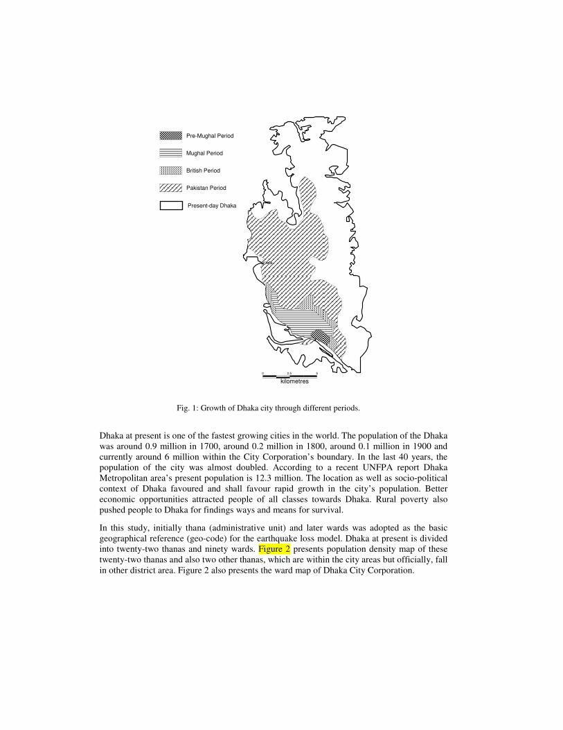
Dhaka stands on the northern bank of the river Buriganga and about several kilometers above
its confluence with the Dhaleswari River. The city, which started around the year 1600 AD on
a small place on the bank of river Buriganga, continued to expand mainly in the northward
direction along the table l and (Madhupur clay) during subsequent times. Beels and
depressions on the east, west and south, which constitute flood plains of the Jamuna and
Meghna rivers, restricted growth in these directions. The growth of the urbanized areas of
Dhaka City through different periods is shown in Figure 1 (Siddiqui, 1990).
Dhaka at present is one of the fastest growing cities in the world. The population of the Dhaka
was around 0.9 million in 1700, around 0.2 million in 1800, around 0.1 million in 1900 and
currently around 6 million within the City Corporation’s boundary. In the last 40 years, the
population of the city was almost doubled. According to a recent UNFPA report Dhaka
Metropolitan area’s present population is 12.3 million. The location as well as socio-political
context of Dhaka favoured and shall favour rapid growth in the city’s population. Better
economic opportunities attracted people of all classes towards Dhaka. Rural poverty also
pushed people to Dhaka for findings ways and means for survival.
In this study, initially thana (administrative unit) and later wards was adopted as the basic
geographical reference (geo-code) for the earthquake loss model. Dhaka at present is divided
into twenty-two thanas and ninety wards. Figure 2 presents population density map of these
twenty-two thanas and also two other thanas, which are within the city areas but officially, fall
in other district area. Figure 2 also presents the ward map of Dhaka City Corporation.
0 2.5 5
kilometres
Present-day Dhaka
Pakistan Period
British Period
Mughal Period
Pre-Mughal Period
Fig. 1: Growth of Dhaka city through different periods.
0
kilometres
52.5
Kotwali
Sutrapur
Ramna
Lalbag
Shyampur
Keraniganj
Demra
Kafrul
DhanmondiHazaribagMotijheel
Kamrangirchar
Sabujbag
Khilgaon
Mohammadpur Tejgaon
GulshanBaddha
Mirpur
Pallabi
Tongi
Cantonment
Airport
Uttara
Population Density per Square Km
13,300 to 26,70026,700 to 40,10040,100 to 53,50053,500 to 66,700
Legend
Survey Areas
0 2.5 5
kilometers
27
66
6364 71
74
72786768
80
70
73 81
7576
77
69
79
82
3231
65
83
87
90
86
84
8530
88
89
6261
60
5629
3336 28
253435
53
5752
50
5958
48
47 24
2354
4951
55 26394544 2237
38
404243
46
20 2110
41
19
18
16
1413
12
1109
04
08
05
07 03
1502
0617
1
Population Density per Square Km
122,000 to 144,00099,000 to 122,00076,000 to 99,00053,000 to 76,00030,000 to 53,000
(a) Thana wise (b) Ward wise
Fig. 2: Population density map of Dhaka.
Natural Disaster
From a natural hazard viewpoint, Dhaka is among the most vulnerable cities in the world.
Floods, fires, earthquakes and tornadoes are among the major hazards (Mitchell, 1999). In this
paper two major natural hazards such as floods and earthquakes are discussed.
Floods
Dhaka is surrounded by a network of rivers – the Turag on the west, the Buriganga on the
south, the Balu on the east, and the Tongi Khal on the north (Figure 3). The historic cause of
floods in Dhaka City is the rise in water levels of the rivers bordering the city. In addition,
internal drainage congestion and un coordinated operation of flow regulation structures may
make the flood situation worse (Faisal et al., 2003).
Fig. 3: Rivers and canals of Dhaka City.
Dhaka has experienced two major floods during the last decades. The 1998 flood has been
one of the most devastating from duration point of view, whereas the water levels in the 1988
flood were among the highest in the last hundred years. After the 1988 flood, the western and
southern parts of the city have been brought under flood protection by constructing the
embankment and floodwalls as per Phase I of Dhaka Integrated Flood Protection Project
(DIFPP). However, these structures could not provide 100% flood protection in 1998 due to
the presence of a few openings in the form of surface and buried drains and discontinuity in
floodwalls. Figure 4 shows the areas that were inundated during the flood of 1998. The
eastern part of the city (to the east of Biswa Road) is not yet protected and all of it was
inundated during the flood of 1998 as shown in Figure 4. This area largely comprises of low-
lying floodplains that goes under water as the water level in the Balu River rises. However,
growing population and land scarcity have forced many people to settle on this flood plain.
Implementation of Phase II of DIFPP will provide flood protection to this part of the city.
Fig. 4: Inundation pattern in Dhaka City during the flood of 1998.
Earthquakes
Seismic Source Zones and Seismicity
Seismic hazard is typically determined using a combination of seismological, morphological,
geological and geotechnical investigations, combined with the history of earthquakes in the
region. Bolt (1987) analyzed different seismic sources in and around Bangladesh during the
feasibility stage of Jamuna bridge project. Bolt identified four major sources of earthquakes:
(i) Assam fault zone, (ii) Tripura fault zone, (iii) Sub-Dauki fault zone and (iv) Bogra fault
zone. Figure 5 shows some of the active faults, which are situated in and around Bangladesh.
Reliable historical data for seismic activity affecting Bangladesh is available only for the last
450 years (Gupta et al., 1986). Recently developed earthquake catalogue for Bangladesh and
surrounding area (Sharfuddin, 2001) showed that sixty-six earthquakes with Ms≥4.0 occurred
from 1885 to 1995 within a 200 km radius of Dhaka city. The most prominent historical
earthquakes affecting Dhaka is listed in Table 1.
Bangladesh National Building Code (1993) placed Dhaka in Seismic Zone 2 with PGA value
of 0.15g (where g is acceleration due to gravity). The seismic zones mentioned in national
code were not based on analytical assessment of seismic hazard and were mainly based on the
0 100
kilometres
200
Bangladesh
Main Boundary Thrust
Trip
ura
Chitta
gong F
old
Belt
Syl
het F
ault
Bogr
a Fau
lt
Brahmaputra Fault
Haluaghat Fault
Naga Thru
st
Haf
long
Thr
ust
Dauki Fault
Area of extensive damage to
masonry buildings
Dhaka India
Myanma
India
Bhutan
X
IX
VIII
VII
VI
V
Bay of Bengal
Epicentre Concealed Faults
Thrust Faults
Fold Axis
Normal Faults
N
Table 1: Magnitude, EMS intensities and distances of some major historical earthquakes
around Dhaka.
Name of the earthquake Magnitude Intensity at Dhaka Distance (km)
1869 Cachar 7.5 V 250
1885 Bengal 7.0 VII 170
1897 Great Indian 8.7 VIII+ 230
1918 Srimangal 7.6 VI 150
1930 Dhubri 7.1 V+ 250
location of historical data. An updated seismic zoning map based on analytical study was
recently developed (Sharfuddin, 2001) which has been presented in Figure 6. This zoning map
was based on consistent ground motion criterion such as equal peak ground acceleration
levels with a return period of 200 years. Based on the philosophy behind the seismic zoning
and experience from recent earthquakes, it can reasonably be assumed that a major earthquake
event in Dhaka region is capable of higher damage than that assumed in the existing zoning
map (BNBC, 1993).
Fig. 5: Active fault locations and isoseismal map of 1897 Great Indian earthquake
)(±+= 10.93P 4.9(logR) - R)0.0007483( - )1.283(M 8.378 I s
Earthquake Scenarios and Associated Probabilities
Due to the non-availability of seismo-tectonic data on lineaments and their level of activity, scenario events were estimated using earthquake catalogues. The earthquake history of Dhaka presented in Table 1 shows evidence of damaging earthquakes at frequent intervals; there were already a few earthquakes with intensity V+ damage during the last 200 years. Based on historical data, it is conceivable that the Dhaka region may experience earthquakes with damage greater than intensity VIII, the level assumed based on 1897 Great Indian earthquake (Oldham, 1899). In this study, an earthquake of maximum EMS intensity (Grunthal, 1998) VIII was used for damage estimation.
Intensity attenuation law developed recently for Bangladesh and surrounding region (Equation 1) by Ansary and Sabri (2002) was used for estimating intensities of sixty-six earthquakes within a 200 km radius of Dhaka and Gutenberg-Richter recurrence relationship was developed to estimate the probabilities for different intensity earthquakes. The probability of exceedance in a design life of 50 years for EMS intensity VIII was 57 %.
Building Inventory Survey and Results
The detailed building inventory survey was discussed in a separate paper (Ansary and Meguro,
2003). Here some salient features relevant to this study are presented.
Fig. 6: Updated seismic zonation map of Bangladesh.
Seismic Zones
Zone 3 = 0.25g
Zone 2 = 0.15g
Zone 1 = 0.075g
1
3
5
≥7500 1500 25003500
5400
0
50
100
150
200
250
300
350
400
Num
ber
of
Build
ings
Number of
Storey
Average Floor Area (sft)
Sutrapur
500
1500
2500
3500
5400
1
3
5
≥7500 1500 2500 3500 5700
0
20
40
60
80
100
120
140
Nu
mb
er
of
Bu
ildin
gs
Number of
Storey
Average Floor Area (sft)
Dhanmondi
500
1500
2500
3500
5700
1
3
5
≥75001500
25003500
5000
0
50
100
150
200
250
Num
be
r of
Build
ings
Number of
Storey
Average Floor Area (sft)
Kafrul
500
1500
2500
3500
5000
Selection of Sample Sites
Dhaka City Corporation is currently divided into ninety wards. Among these, eight wards
(ward number 73, 74 and 77 of Sutrapur thana; ward number 47, 48 and 49 of Dhanmondi
thana; ward numbers 14 and 16 of Kafrul thana) were selected based on their settlement age
and locations. These are widely apart and represent the different settlement pattern of the city.
Figure 2 shows the location of these wards in Dhaka city. The main target was estimating the
likely building damage due to the scenario earthquakes with a certain level of ground shaking:
how the buildings are constructed and the likely response of the buildings to such shaking.
The building inventory survey covered mostly urban and partly semi-urban in nature. It also
covered the commercial and the industrial (light industry) areas.
Building Typology and Classification
The building inventory survey helped to classify all buildings in Dhaka into five types based
on their definition in European Macroseismic Scale (Grunthal, 1998). Table 2 shows the
description of each typology.
Table 2: Definition of building typologies in Dhaka.
No. Types Description
1 EMSB1 1-storied brick masonry of fired bricks with cement or lime mortar; roof is
either of GI sheet or other materials.
2 EMSB2 2-storied or taller brick masonry of fired bricks with cement or lime mortar;
roof is generally made of RCC slab. Some weak and old reinforced concrete
frame.
3 EMSC Reinforced concrete frame with low ductility; designed for vertical load only.
4 EMSD Reinforced concrete frame with moderate ductility; designed for both vertical
and horizontal loads.
5 EMSF Mainly bamboo, wooden and steel structures.
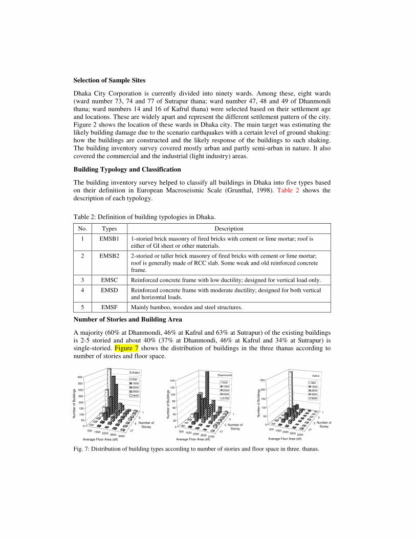
Number of Stories and Building Area
A majority (60% at Dhanmondi, 46% at Kafrul and 63% at Sutrapur) of the existing buildings
is 2-5 storied and about 40% (37% at Dhanmondi, 46% at Kafrul and 34% at Sutrapur) is
single-storied. Figure 7 shows the distribution of buildings in the three thanas according to
number of stories and floor space.
Fig. 7: Distribution of building types according to number of stories and floor space in three. thanas.
In the residential areas, RAJUK or Rajdhani Unnayan Kartripakha (Capital Development
Authority) generally do not allow structures beyond 6 stories. But from Figure 7, it can be
seen that in Dhanmondi and Sutrapur areas less than 1 % is taller than 6-storied. Some of
them may be approved by RAJUK and the owner may extend some beyond the approved plan.
Each year at least 10 to 20 such structures collapse in Dhaka due to one reason or other. In the
newly developed Kafrul area, the percentage is higher (around 2.1%), as there are many
Government constructed high-rise housing complexes and offices.
In Dhanmondi area, the average house sizes are comparatively larger than Sutrapur and
Kafrul areas, where residents are comparatively affluent. In Sutrapur (which is an old
settlement), the house sizes may also be decreasing due to division of the original plot among
successors of the original owner. Similar process has also started in Dhanmondi area recently,
due to the local custom of succession of property and due to higher price of land there. Most
of the old houses are demolished and the developers are constructing luxurious apartment
buildings. The building inventory data obtained for the three thanas together with BBS (2001)
data were utilized for estimation of housing units and their story-wise distribution, for the rest
of the twenty-one thanas.
Disaster Scenario
For floods, the damages due to 1998 flood are presented and for earthquakes, damages due to
a scenario earthquake are presented below.
Floods
In 1998, several floods passed through the country since early July. The flood situation started
to worsen in the beginning of July due to heavy rainfall in the entire catchment area of the
Ganges-Brahmaputra-Meghna system (Islam et al., 2003). Compared to the normal rainfall in
the July–August period, the rainfall was 40% higher in July and 35% higher in August. As a
result, water levels in all major rivers showed a significant rise.
The water levels in the rivers surrounding Dhaka approach the respective danger levels in the
second half of July but cross the danger levels in mid-August. Peak flows occur typically in
the last week of August and the first two weeks of September and flood water recedes in the
last ten-days of September (Figure 8). The floods of 1987 and 1988 followed this pattern.
However, during the flood of 1998, water levels crossed the danger levels almost a month
earlier and stayed there until the last week of September. The main difference between the
floods of 1988 and 1998 as seen in Figure 8, is that the former peaked very quickly in mid-
August and had duration of about four weeks. The latter showed a smaller early peak, which
prevailed until the arrival of a second peak in the second week of September. Finally the
water levels receded in the last week of September. Thus the duration of 1998 flood was more
than two months making it the longest flood in the history of Dhaka City. In terms of flood
height, 1988 flood peaks were higher compared to the peaks of 1998.
Major Findings from the Analysis of the 1998 Flood
Based on the analysis of the 1998 flood as presented above, a number of important findings
are listed below in relation to flood mitigation in both the western and eastern parts of the
city.
Findings for the Western Part of Dhaka
The western part of Dhaka City is largely protected by the embankment constructed after
1988 flood as per Phase I of DIFPP. Even then, about 20% of this part of the city was
inundated in 1998 due to the following reasons:
Fig. 8: Flood hydrographs for the Tongi Khal
Box 1. Damages to important infrastructure of Dhaka City during the flood of 1998 (Islam et al.,
2003)
i. Hydraulic leakage through un-gated drainage pipes and culverts;
ii. Delayed closure of the regulator gates at Rampura Bridge;
iii. Inadequate pumping from the retention storage;
iv. Leakage through incomplete segments of the floodwall along the Buriganga River;
v. Significantly reduced drainage capacity due to accumulation of solid waste and silt;
vi. Lack of coordination between organizations responsible for flood control and drainage;
vii. Partial completion of DIFPP.
It may be mentioned here that the embankment along the Turag River played a crucial role in
protecting the western part of the city during 1998 flood even though its construction was not
completed as per design. Specifically, the berm on the countryside was not constructed and
the crest width was found to be less than the design width in some parts of the embankment.
As a result, there was a serious threat of seepage failure of the embankment, which was
countered by holding water on the countryside with the help of sandbags.
Findings for the Eastern Part of Dhaka
The eastern part of Dhaka is flooded annually, as it is largely an unprotected lowlying flood
plain. Anticipation of construction of the embankment along the Balu River had already
triggered rapid urbanization in this part with little supervision from the city planning
authority. Many structures are being built with low plinth level, which will be inundated in
case of a major flood. The city planners must adopt and enforce proper land use plans in this
area to prevent major economic loss and human sufferings in future. A very important aspect
of the land use plan for Dhaka East would be the open areas to be developed as retention
ponds to prevent massive water logging. Unless these areas are identified and preserved now,
these will be taken up by urban developers and the city authority may have to buy these areas
back at a much higher price compared to their present value.
Earthquakes
Microzonation
For the present analysis, a GIS based map of Dhaka was developed based on 1:20000 scales
Survey of Bangladesh map published in 2001. For the GIS analysis MapInfo software was
used. Figure 9 shows the geological map of Dhaka based on the above GIS map. The
Madhupur clay and old natural levee areas (termed as Madhupur Clay) were assumed to be
non-liquefiable and the rest of the area, i.e., flood plain, active natural levee and abandoned
channel areas (termed as Flood Plain) were assumed to be liquefiable. For the earthquake loss
estimation this simplified map has been used.
Figure 10 presents site amplification and liquefaction potential maps of Dhaka, which have
been developed very recently by Ansary (2003). The site amplification map has three zones
with the following characteristics: zone 1 with resonant frequency of less than 3 Hz and mean
ground motion amplification of 2.5; zone 2 corresponds to resonance frequencies in a band of
3 to 5 Hz having a ground motion amplification of 1.8; zone 3 corresponds to resonance
frequency greater than 5 Hz and mean ground motion amplification of 1.8 Hz. The
liquefaction map has two zones: a zone with liquefaction possibility and the other with no
liquefaction possibility.
Vulnerability Function
In this study, fragility curves for the buildings in Dhaka were prepared by calibrating the
existing fragility curves for Indian buildings prepared by Arya (2000) and for Nepalese
buildings prepared by Bothara et al. (2000). There exist a number of fragility curves for
different types of structure and different earthquake intensities but according to the authors’
experience, the Indian and Nepalese curves are most suitable for Bangladeshi structures.
Figure 11 present the fragility curves for EMSB1, EMSB2, EMSC, EMSD and EMSF type
structures.
Neither Arya (2000) nor Bothara et al (2000) mentioned the types of damages (i.e., collapsed
or heavily or moderately damaged) to be estimated using those fragility curves. Segawa et al.
(2002) used those curves after some calibration and quoted those curves to be developed for
heavily damaged structures. For this study, based on some previous findings from damaging
earthquakes in India (Arya, 2000; Jain et al., 2002; NSET and DEQ-UOQ, 2000), it was
assumed that complete (damage grade G5) and partial collapse (damage grade G4) structures
comprise 25% of EMSB and EMSC damage, heavily damaged structures (damage grade G3)
comprise 40% of EMSB and EMSC damage, moderately damaged structures (damage grade
G2) comprise 15% of all type total damage and low damaged structures (damage grade G1)
comprise 20% of all type total damage.
0 2.5 5
kilometers
Legend:
Flood Plain (37.7 percent)
Madhupur Clay (62.3 percent)
N
Fig. 9: Geological map of Dhaka.
LQFAC
PossibilityNo-possibility
Amplification
Zone 3Zone 2Zone 1
Fig. 10: Seismic microzonation maps for Dhaka.
Building Damage
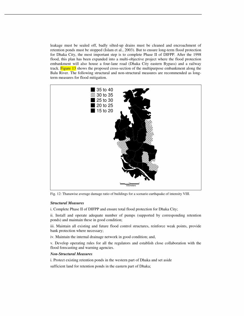
The intensity variation map is the same as the geological map of Dhaka as presented in Figure 9. Maximum intensity of the scenario earthquakes was assigned to the flood plain area (37.7 %) and one degree less intensity was assigned to the rest of the area with Madhupur clay (62.3 %). Damage ratios for each thana were obtained for the scenario earthquake with maximum intensity of VIII using the intensity variation as defined earlier and the fragility curves of Figure 11. In total, on an average 28% of buildings were estimated to be damaged by intensity VIII earthquake. On the other hand, for intensity VIII earthquake, thana wise damage distribution varies between 16 to 40%. Figure 12 presents thanawise damage ratios for intensity VIII earthquake. Thanas, which are situated in southeastern part of Dhaka showed greater building damage ratio, this result is consistent with the existing soil condition in those areas.
It is interesting to note that during the 2001 Bhuj earthquake (maximum EMS intensity X),
over 980,000 masonry structures experienced medium to severe damage and 230,000 were
collapsed in Gujarat (Jain et al., 2002). Total death toll was around 15,000 and injuries were
170,000. The Bhuj city (EMS intensity IX) located 70 km from the epicenter with a
population of only 150,000 experienced around 10,000 deaths, 90% of masonry structures of
old Bhuj collapsed and most of the reinforced concrete structures were badly damaged. Even
many mid to highrise buildings of Ahmedabad (EMS intensity VII), a city 300 km away
experienced collapse and heavy damages. Since Dhaka is a much larger city and the building
stock is larger than Ahmedabad and Bhuj, the expected damage will be consequently much
higher.
Human Casualty
In order to assess the human casualty levels due to the earthquake, the estimates of average
fatality and injury levels were estimated using a mortality prediction model for different
categories of structures derived these figures. This prediction model is based on investigation
0
10
20
30
40
50
60
70
80
90
100
IXVIIIVIIVI
Based on EMS Scale
B1
B2
C
D
F
Ave
rag
e L
oss R
atio (
%)
Intensity Caused by an Earthquake
of casualty due to several major earthquakes that occurred during this century (Coburn et al.,
1992). The total number of people that may be killed due to damage of each building type can
be represented by:
Ksb = Db * [M1b * M2b * M3b * M4b] (2)
Where, Db is the total number of damaged structures of building type b, M1 is the occupant
density and M2 to M4 are conditional probability factors to modify the potential casualty
figures. The factor M1 represents the population per building. For this investigation, M1 was
taken as 5 (BBS, 2001). M2 is the occupancy of buildings at the time of earthquake. The
occupancy cycle proposed by Coburn and Spence (1992) was used. Depending on the time of
the earthquake, the occupancy rate can been found from this figure. M3 is the proportion of
occupants who are trapped by collapse of buildings. This depends on the type of building. M4
is the proportion of occupants who are either killed or injured in the earthquake. It was
observed that collapsed multi-storied masonry and reinforced concrete buildings lead to death
of a large number of trapped occupants, while collapsed masonry buildings lead to death of
relatively small number of trapped occupants.
Fig. 11: Fragility curves for different building types based on EMS intensity.
The Dhaka building inventory, census information, earthquake hazard and vulnerability data
and the mortality information were combined to estimate the number of possible injuries and
the corresponding deaths that may occur due to earthquakes of different strengths. The
occurrence of an earthquake of EMS Intensity VIII at Dhaka may lead to massive loss of life
and damage of buildings. Depending on the time of the day, from 22000 to 28000 people may
perish due to structural collapse and damage in the earthquake. The numbers of serious
injuries may also range from 86000 to 107000, possibly placing a very severe strain on the
emergency relief and health-care infrastructure.
Mitigations of Floods
Some mitigation strategies for floods and earthquakes are discussed below.
Long-Term Strategies for Flood Mitigation
Some of the shortcomings of the current flood management practices have to be addressed
immediately to protect Dhaka City from flooding. As short-term measures, all hydraulic
leakage must be sealed off, badly silted-up drains must be cleaned and encroachment of
retention ponds must be stopped (Islam et al., 2003). But to ensure long-term flood protection
for Dhaka City, the most important step is to complete Phase II of DIFPP. After the 1998
flood, this plan has been expanded into a multi-objective project where the flood protection
embankment will also house a four-lane road (Dhaka City eastern Bypass) and a railway
track. Figure 13 shows the proposed cross-section of the multipurpose embankment along the
Balu River. The following structural and non-structural measures are recommended as long-
term measures for flood mitigation.
Fig. 12: Thanawise average damage ratio of buildings for a scenario earthquake of intensity VIII.
Structural Measures
i. Complete Phase II of DIFPP and ensure total flood protection for Dhaka City;
ii. Install and operate adequate number of pumps (supported by corresponding retention
ponds) and maintain these in good condition;
iii. Maintain all existing and future flood control structures, reinforce weak points, provide
bank protection where necessary;
iv. Maintain the internal drainage network in good condition; and,
v. Develop operating rules for all the regulators and establish close collaboration with the
flood forecasting and warning agencies.
Non-Structural Measures
i. Protect existing retention ponds in the western part of Dhaka and set aside
sufficient land for retention ponds in the eastern part of Dhaka;
0
kilometers
52.5
35 to 4030 to 3525 to 3020 to 2515 to 20
ii. Improve the flood forecasting and warning system, provide forecast in terms of potential
area of inundation;
iii. Build public awareness on flood preparedness through NGOs and the media;
iv. Undertake awareness campaigns to prevent indiscriminate disposal of garbage in the
surface and subsurface drains of the city;
v. Streamline institutional bottlenecks and assign all flood-related responsibilities to DWASA
and BWDB as appropriate;
vi. Introduce rules and regulations for proper land use in the eastern part of Dhaka;
vii. Introduce mandatory flood proofing for new buildings in the eastern part of Dhaka;
viii. Provide flood warning and flood shelter;
ix. Ensure cost sharing by GOB and floodplain dwellers.
Fig. 13: Cross-section of the multipurpose embankment along the Balu River.
Long-Term Strategies for Earthquake Risk Mitigation
Bangladesh achieved remarkable success in managing frequently occurring hazards such as
cyclones and floods. The country has a well-organized Cyclone Preparedness Programme
(CPP), which boasts a volunteer list of around 36000 who may be mobilized along the 700
km long coastal belt within a few hours. Some other countries prone to cyclones and storm
surges are trying to emulate CPP. To cope with the earthquake disaster a similar Earthquake
Preparedness Programme (EPP) needs to be implemented.
For earthquake disaster mitigation professional as well as government solution is required.
Architects, engineers, geologists, planners etc. will provide technical aspects and NGOs, mass
media and social scientists will provide social aspects of professional solution. Builders,
financial institutions, land developer would be required to support professional solution.
Government agencies can help to implement professional solution through policymaking and
policy enforcement. Government solution should clearly point out regulatory jurisdiction of
each organization. For earthquake disaster mitigation following pre and post measures should
be undertaken on an urgent basis.
Awareness and capacity building
• Increase public awareness through education (school children), earthquake drills,
interactive website, mass-media, publication, training etc.
• Training of building inspectors, community leaders, construction workers and masons.
• Installation of free field accelerographs and seismographs for engineering and seismology
studies.
• Seismic hazard assessment based on free field data and source models.
• Vulnerability assessments of structures using structural analysis and nondestructive
testing. Develop laboratory and testing facilities.
• Development of indigenous and cheap retrofitting measures.
• Microzonation of urban areas based on different soil effects.
• Updating building code.
Earthquake resistant construction
• Legal enforcement of building code.
• Proper use of ductile steel and lateral force resisting systems.
• Building insurance to promote earthquake resistant construction.
• Retrofitting critical structures such as schools, hospitals and fire offices.
• Urban and regional planning to mitigate earthquake effects.
Post-earthquake response
• Develop automatic safety shutdown system for electricity, gas, telephone and water supply system whenever the ground shaking exceeds a certain limit.
• Develop facilities for post earthquake search and rescue operation.
• Local people and organizations most effectively do rescue of victims because they are able to carry this out more quickly than outside agencies. Community based voluntary group should be trained who can actively participate in rescue operation just after an earthquake disaster.
• Prepare contingency plans.
• Coordination among different interest groups those will be involved in the post earthquake rescue effort.
• Arrangement of emergency medical treatment facilities for injured people.
Current Efforts
In the following paragraphs a brief summary of activities undertaken by different
organizations of Bangladesh to mitigate earthquake disaster are presented.
Bangladesh University of Engineering & Technology (BUET)
Department of Civil Engineering, BUET offers postgraduate courses on Earthquake
Engineering, Soil Dynamics, Structural Dynamics and Vibration Analysis. Until 1996, their
existed only two postgraduate theses linked with Earthquake Engineering. But after 1996, six
more postgraduate theses related to this field were completed. Currently two students are
pursuing their PhD and four more students are pursuing for their Master’s thesis in the
Department in Earthquake Engineering field.
Department of Civil Engineering, BUET is working as a consultant to the 4.8 km long
Jamuna Multipurpose Bridge to monitor the seismic instruments that the Department’s faculty
members helped to be installed in July 2003. In addition to the seismic instrumentation of the
bridge, there is a borehole accelerograph at 57 m depth and seven free-field seismic
instruments at Bogra, Natore, east and west end of the bridge, Mymensingh, Gazipur and
Dhaka.
In April 2002, BUET put forward a proposal for the establishment of a National Center for
Earthquake Engineering (NCEE) and included it in BUET’s next five-year plan for
implementation. In March 2003, an MOU was signed between NCEE and ICUS, University
of Tokyo. Recently, a linkage is established between Virginia Polytechnic Institute, USA and
NCEE with USAID funding.
After the recent Bangladeshi earthquakes several BUET team performed field surveys
(Ansary et al., 2001, Ansary et al., 2003). The first author also visited earthquake-affected
parts of Gujarat state of India as mentioned earlier with GERIT (Mistry et al., 2001) under the
joint sponsorship of EMI-WSSI. The author has also contributed two reports one on
unreinforced masonry and the other on mud houses to the EERI’s World Housing
Encyclopedia Project.
Government Agencies
Disaster Management Bureau (DMB) was established with the help of UNDP and UNICEF in
1993. Although initially it was established to manage flood and cyclone, after the 1997
earthquakes in Chittagong and Sylhet region, Bureau started to train different government
officials and volunteers about pre and post-earthquake preparedness and management
techniques. For the last couple of years, Bureau conducted fifty or more earthquake training
workshops in different regions of Bangladesh. In 2002, it also published a Disaster
Management Training Manual. The second part of the manual has a complete chapter on
Earthquake Training Module and Public Awareness Guidelines.
The Ministry of Disaster Management & Relief (MDMR) is currently working as the
government coordinator for all activities regarding earthquake. Recently, they asked all the
concerned ministries, departments and armed forces division to submit Contingency Plan
regarding earthquake. The Ministry also compiled a list of available rescue and recovery
equipment available in the country. MDMR is currently taking preparation to hold a mock
drill in the mid week of December 2003. It will be held in the Dhupkhola field at the old part
of Dhaka city, where the current population density exceeds 70000 per sq. km.
The second phase (2003-2008) of Program for Enhancement of Emergency Response (PEER),
a USAID funded international project includes Bangladesh with the existing four other PEER
affiliated countries – India, Indonesia, Nepal and Philippines. The program aims to strengthen
and institutionalize capacities in emergency and disaster response of the member countries.
An MOU in this regard will soon be signed between PEER and Ministry of Disaster
Management & Relief (MDMR).
In 2001 Bangladesh Meteorological Department (BMD) initiated a project to establish four
broadband seismic stations at Rangpur, Sylhet, Dhaka and Chittagong cities.
Public Works Department (PWD) is responsible for constructing all the government buildings
of the country. For the last two years, the Department arranged several in-house workshops to
train their engineers about earthquake resistant design. Also the engineers of this organization
have started to use seismic codes in designing buildings.
Bangladesh Armed Forces Division (AFD) played a significant role in all past disaster
management in the light of the tasks assigned in the “Standing Order on Disaster, 1999”
circulated by MDMR. Recently, Bangladesh Armed Forces, in consonance with the national
initiative, chalked out a contingency plan for Dhaka city (Rasul, 2003). According to the
AFD’s contingency plan, the city is divided into eight sectors with predefined tasks after an
earthquake. AFD will also activate “Disaster Management and Relief Monitoring Cell” at
Prime Minister’s Office after an earthquake.
Geological Survey of Bangladesh (GSB) is the oldest organization in the country involved
with the development of seismic zonation maps. The organization was instrumental in
developing the 1972 and 1979 seismic zonation maps (Choudhury, 1993). But unlike its
predecessor the Geological Survey of India (GSI) under the British rule, it did not initiate any
research in earthquake field. Currently it depends on USGS and GSI for earthquake source
information.
Bangladesh Earthquake Society
Bangladesh Earthquake Society (BES), a non-government voluntary organization was established on April 2002 and was registered on January 2003. The first election of the society was held on August 2003 and a 12 member executive committee (EC) was elected. The EC members consist of engineers, geologists, NGO activists and government administrators.
BES also organized two national level workshops and held four monthly seminars so far. The first workshop was jointly organized with RAJUK [Capital Development Authority] on August 21, 2003 to train the engineers of Bangladesh about the earthquake resistant design. The second workshop was organized together with Disaster Management Bureau (DMB), Ministry of Disaster Management and Relief on September 4, 2003 to sum up the findings of 2003 Rangamati Earthquake. Both the workshops put forward a set of recommendations to be implemented either by the government or by the NGOs with the help of donor agencies. The second workshop was the first of its kind where architects, armed forces personnel, engineers, geologists, NGO activists and government officials presented their papers. In March 2003, an MOU was signed between BES and ICUS, University of Tokyo.
Non-government Organization
CARE-Bangladesh is involved in the disaster related field of Bangladesh for the last thirty years. But only after the 2001 Gujarat Earthquake, it focused its attention in earthquake disaster. Some recent activities of CARE are: Circulation of pamphlets among the general masses on communities’ role before, during and after an earthquake; development of seismic risk scenarios for different cities of Bangladesh; planning to circulate IAEE’s manual for the seismic design of non-engineered construction in Bengali; arranging different earthquake sensitization seminars and workshops in different parts of Bangladesh.
Bangladesh Red Crescent Society (BDRCS) also arranged a seminar to discuss their role before, during and after an earthquake in line with MDMR’s policy in September 2003. Similarly some NGOs and societies such as ActionAID, CARITAS, EPRC, FBAST, GJKS, JUUAB, SAFE and SDF organized seminars and workshops on earthquake risk mitigation in different cities of Bangladesh.
Other Organizations
Bangladesh Insurance Academy (BIA) conducted the first workshop on catastrophic risk management in 1998. The second workshop on similar topic was just held on November 2003.
Recently, BRAC University together with ADPC, Bangkok organized a two weeklong
workshop on Earthquake Vulnerability Reduction in Cities (EVRC3).
Conscience for Existence, a student organization of BUET worked at the community level of
one of the wards of Dhaka city (Ratan et al., 2003). Recently, the group organized an
exhibition to share their experience of the survey carried out in the community level of the old
Dhaka.
Department of Civil Engineering, Chittagong University of Engineering & Technology
(CUET) established an Earthquake Research Centre in 2001. It started a joint research
together with the University of Macedonia, Skopje. Under the agreement faculty members of
CUET are regularly trained in Skopje.
Geohazards Research Group (GRG) of the Department of Geology of Dhaka University in
cooperation with Lamont-Doherty Earth Laboratory of the University of Columbia, USA
installed a broadband seismometer in Dhaka (Khan, 2003) and several GPS devices at some
places of Bangladesh recently. The Department also got funding from Ministry of Science &
Technology (MOST) to carry out research in the field of earthquake hazard assessment for
2003-2004. Recently, Dhaka University administration has started to assess the vulnerability
of their existing buildings and halls to prioritize their retrofitting measures.
Institute of Engineers Bangladesh (IEB) organized several seminars on earthquakes. Currently it is offering some courses on earthquake resistant design together with Engineering Staff College, Bangladesh.
Institute of Diploma Engineers Bangladesh (IDEB) also offered several courses on earthquake vulnerability and seismic design of structures.
Real Estate and Housing Association of Bangladesh (REHAB) also conducted one seminar after the 2001 Bhuj Earthquake.
Department of Civil Engineering of SUST and BUET under the guidance of the first author is currently working to develop seismic microzonation map of Sylhet. Also building data survey for particular wards of Sylhet were carried out.
In 2002, UNDP submitted a Comprehensive Disaster Management Program (CDMP) proposal to the forum of donor agencies. It got donor communities approval in early 2003. The sub-program 4 (a)-ii of the PCP contains an urban risk research component on urban earthquakes. The objective is to facilitate an expansion of mitigating programs through initiating studies to obtain in-depth knowledge about the earthquake threat and related risks in the urban areas recommending mitigation measures for selected cities of Bangladesh.
Mass Media
Mass media such as newspapers and television networks played a vital role during the recent
2003 Rangamati Earthquake. They covered and broadcasted as much information as they
could collect from the affected areas of Barkal, a remote hilly town. The journalists followed
the different expert team who visited the earthquake-hit areas and published their findings in
the National Dailies and showed live footage in the Television News. Currently newspapers
have taken initiative to regularly publish news of earthquakes and interviews of local
earthquake experts and their research activities, which will certainly enhance public
awareness level.
Conclusions
Originally designed to be home to a million people before the country’s independence in 1971,
Dhaka has since grown into a chaotic megacity of 12 million. In addition, Dhaka is burdened
with haphazard and unplanned development. Also, significant flood and earthquake risk exist
for the City. Under Flood Action Plan, the Western part of the City has become free from
flood risk; the Eastern part is still vulnerable to floods. Although there is no potential seismic
source zone of major earthquake near Dhaka City, the occurrence of a similar earthquake of
1897 with intensity between VII to VIII in Dhaka may cause havoc for the City as well as the
country itself. The recent actions undertaken by government and non-government
organizations to reduce earthquake risks are praiseworthy.
Acknowledgment: The authors would like to acknowledge MOST, GoB grant in 1998-1999 and CARE-
Bangladesh fund in 2001-2002 through which building inventory data of Dhaka and other cities were
collected.
References
Ansary, M. A., Al-Hussaini, T. M., Sharfuddin, M. and Choudhury, J. R. 2001. 1999 Moheskhali
Earthquake: A Damage Study, Journal of Asiatic Society of Bangladesh, 27 (2), 139-149.
Ansary, M. A. 2003. Site amplification study of Dhaka city by using microtremor observation, CASR
Research Project Report, Department of Civil Engg., BUET, Dhaka.
Ansary, M. A. and Meguro, K. 2003. A study on damage scenarios for buildings in Dhaka, Bangladesh,
Natural Hazards (accepted for publication).
Ansary, M. A. and Sabri, S. A. 2002. Magnitude-Intensity and Intensity-Attenuation Relationships for
Earthquakes in Bangladesh and Surrounding Region, Engineering Seismology (under review).
Ansary, M. A., Sadek, A. and Al-Hussaini, T. M. 2003. 2003 Rangmati earthquake and engineering
assessment. Proceedings of the seminar on 2003 Rangamati Earthquake, September, Dhaka.
Arya, A. 2000. Non-Engineered Construction in Developing countries - An Approach toward
earthquake Risk Prediction, Proc. of 12th World Conference on Earthquake Engineering, New
Zealand No. 2824 (published in CDROM).
BBS, 2001. Population Census 2001: Preliminary Report, Statistics Division, Ministry of Planning,
Government of Bangladesh.
BNBC, 1993. Bangladesh National Building Code, HBRI-BSTI.
Bothara, J. K., Parajuli, Y. K., Arya, A. S. and Sharpe, R. D. 2000. Seismic Safety in Owner-Built
Buildings, Proc. of 12th World Conference on Earthquake Engineering, New Zealand, No. 2130
(published in CDROM).
Choudhury, J. R. 1993. In Meguro, K and Katayama, T. (editors): Seismicity in Bangladesh,
Proceedings of the WSSI Workshop, February, Bangkok.
Coburn, A. W. and Spence, R. J. S. 1992. Earthquake Protection, John Wiley & Sons, Cambridge, UK.
DMB 2002. Disaster management training manual, published by Disaster Management Bureau, MDMR.
Faisal, I. M., Kabir, M. R. and Nishat, A. 2003. The Disastrous Flood of 1998 and Long Term
Mitigation Strategies for Dhaka City. Natural Hazards 28, 85-99.
Grunthal, G. 1998. European Macroseismic Scale, Luxembourg: Cahiers due Centre European de
Geodynamique et de Seismologie, 15.
Gupta H. K., Rajendran, K. and Singh, H. N. 1986. Seismicity of the northeast India region part I: the
data base, Journal of Geological Society of India, 28, 345-365.
Jain, S., Lettis, W. R., Murthy, C.V.R. and Bardet, J. P. 2002. Bhuj India Earthquake of January 26,
2001, Reconnaissance Report, Earthquake Spectra, Supplement A to Vol.18.
Khan, A. A. 2003. Earthquake scenario of Bangladesh in reference to Kolabunia earthquake of July 27,
2003-vulnerable assessment of megacities, Proceedings of the seminar on 2003 Rangamati
Earthquake, September, Dhaka.
NSET and DEQ-UOQ, 2000. Reconnaissance Report Chamoli Earthquake of 29th March 1999, India,
Joint Study by NSET-Nepal and DEQ-UOR, India.
Oldham, R. D. 1899. Report on the great Indian earthquake of 12th June, 1897, Memoir of Geological
Survey of India, 29, 1-349.
Mitchell, J. K. 1999. Megacities and natural disasters a comparative analysis. GeoJournal 49, 137-142.
Rasul, I. I. 2003. Contingency plan of Bangladesh armed forces for earthquake disaster management in
Dhaka city, Proceedings of the seminar on 2003 Rangamati Earthquake, September, Dhaka.
Ratan, M. A. A., Kashem, M. S. B., Hoque, M. M. and Ansary, M. M. 2003. Participatory community
based disaster management: experinces from old Dhaka. Proceedings of the seminar on 2003
Rangamati Earthquake, September, Dhaka.
Segawa, S., Kaneko, F., Ohsumi, T., Kagawa, H. and Fujitani, H. 2002. Damage Estimation of
Buildings in Kathmandu Valley and Proposals for Improvement of the Earthquake Resisting