1 Village Development Plan of Kallanchiya GN Division at Galgamuwa DS Division Climate Change and Disaster Risk Sensitive Village Development Plan Kallanchiya GN Division Galgamuwa Divisional Secretariat Kurunegala Climate Change Adaptation Project (C-CAP) Ministry of Disaster Management United Nations Development Programme 2016 By Indu Abeyratne, Village Development Planning Specialist
Transcript
1 Village Development Plan of Kallanchiya GN Division at Galgamuwa DS Division
Climate Change and Disaster Risk Sensitive Village Development Plan
Kallanchiya GN Division
Galgamuwa Divisional Secretariat Kurunegala
Climate Change Adaptation Project (C-CAP) Ministry of Disaster Management
United Nations Development Programme 2016
By Indu Abeyratne, Village Development Planning Specialist
2 Village Development Plan of Kallanchiya GN Division at Galgamuwa DS Division
Preface
Building a safe, secure, and resilient community is one of the strategic goals of the Sri Lanka’
Comprehensive Disaster Management Programme of the Ministry of Disaster Management (MDM).
United Nations Development Programme (UNDP) directly supports the attainment of this goal by
providing financial and technical assistance to improve economic and social infrastructure and public
sector service delivery. This publication documents the output from a pilot adaptation project,
facilitating the risk sensitive village development planning through participatory development
initiatives at ground. The project focuses on three key areas: (i) fast-tracking and scaling up climate
change adaptation measures, (ii) building capacity to enable the integration of climate change into
national development plans and programs, and (iii) promoting disaster and climate change sensitive
development planning process. The project was funded under its Special Climate Change Fund
(SCCF) of Global Environment Facility (GEF) which assists in enhancing country initiatives on climate
change. The SCCF focuses on developing and pilot-testing innovative, low-cost adaptation
interventions in line with UNDP’s conscious effort to synthesize and disseminate lessons on effective
climate change adaptation responses. This publication is part of a series of community development
plans designed to facilitate Divisional Secretariat division level planning process which is based on
projected risks, and to provide a better understanding of what makes adaptation actions effective.
UNDP’s support for the project highlights its commitment to put in place climate change solutions
that are adapted to local contexts and guided by the interests of local communities, including the
vulnerable.
The MDM views local adaptation and community participation as crucial in addressing the diverse
range of physical and human geographic circumstances in the country, which express themselves in
differing patterns of vulnerability and in the varying levels, timing, and nature of climate change risks.
We hope that this publication will provide insights into how climate change adaptation may be
strengthened and accelerated through community-based risk assessment and participatory planning.
The process and tools used in the project were designed in consultation with divisional level officials,
the communities, local experts, relevant government agencies, and other development
organizations. MDM and UNDP encourage replication of the process and tools in ways that are best
suited to local conditions and the needs of vulnerable communities.
3 Village Development Plan of Kallanchiya GN Division at Galgamuwa DS Division
Executive Summery
Today uncertainties associated with climate variability poses great risks to the economic
development all over the world. Sri Lanka has reasons to be concerned about climate change. Its
population depends upon climate-sensitive sectors like agriculture and forestry for its livelihood. Any
adverse impact on water availability due to changes in rural ecosystem, decrease in rainfall and
increased flooding in certain pockets would threaten food security, pose risk to the natural
ecosystems including species that sustain the livelihood of rural households, and adversely impact the
coastal system due to sea-level rise and increased extreme events.
A culture of resilience provides a way to reduce vulnerability to disasters and their impacts before they
occur, with the potential to decrease disasters’ costs and consequences. However, building the culture
and practice of disaster resilience is not simple or inexpensive. Decisions about how and when to
invest in increasing resilience involve short- and long-term planning and investments of time and
resources prior to an event.
In this context Ministry of Disaster Management is implementing a Climate Change Adaptation
Project (C-CAP) with the support of UNDP Sri Lanka for four years in most vulnerable districts to
climate induces disasters in Puttalam, Kurunegala and Ratnapura. The project scope is in line with the
Community resilience Framework which will be key guiding framework for risk sensitive development
in the country in future which was developed under the Sri Lanka Comprehensive Disaster
Management Programme.
In order to address above risks, the project aims to build adaptability to climate change into the
design and implementation of developments planning. Building resilience in rural development
programmes to current and projected climatic change will include developing institutional capacities
to assess risk, designing appropriate interventions and implementing adaptation actions with
community participation.
This Village development Plan (VDP) for Kallanchiya Grama Niladhari Division (GND) in Galgamula
Divisional Secretariat (DS) Division in Kurunegala District will provide a better outlook of future
development planning measures derived based on disaster and climate change sensitive lenses which
will be support division level planning to be more focus on risk base.
The VDP has developed on a comprehensive risk assessment led by the Village Development
Committee (VDC) chaired by the GN officer with the support of Development Officer, Social Service
Officer and Agriculture Research Assistant with the guidance of Divisional Secretary and the
leadership of the Assitant Director of Planning at the Galgamuwa DS Division.
The VDP is articulated based on the Guidelines developed by the Ministry on Climate Resilient Village
Development Planning thorough the Climate Change Adaptation Project (C-CAP).
4 Village Development Plan of Kallanchiya GN Division at Galgamuwa DS Division
Acknowledgement
Author would like to acknowledge the enormous support given by the Divisional Secretary of
Galgamuwa and Assistant Director Planning in working with the Kallanchiya division and their officials.
Further special note goes to the Grama Niladhari of Kallanchiya GN division and also development
officer, social service officer and agriculture research assisting officer assigned to the division. Special
acknowledgement goes to relief Service officer attached to the Divisional Secretariat, who has helped
out of the way throughout the process.
Special appreciation to the people of Kallanchiya village for their commitment and cooperation in the
data collection and mapping exercises, and their active participation in the village development
process.
Author wishes to specially note appreciation to the C-CAP team and also National Project Director,
national Project Coordinator and technical specialist for their guidance and contribution. Further
author wishes to convey appreciation to all UNDP officials who are attached to the project for their
continuous support in delivering targets.
5 Village Development Plan of Kallanchiya GN Division at Galgamuwa DS Division
1. Background & Context
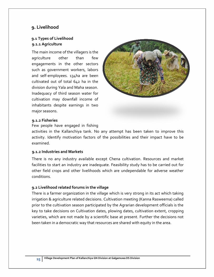
1.1 Introduction
Kurunegala District, which is situated in North Western Province, is comprised of 30 Divisional
Secretariats (DS) and 47 Grama Niladhari Divisions (GNDs), of which 12 are within the Municipal
area.
The population of the District is just over 1.5 million and Kurunegala City has a population of 28571.
The labour force participation rate in Kurunegala District was found to be around 51% with almost
twice as many men as women (DCS 2004; DCS 2003). Figures for the DS Division were not
available. The literacy rate of the population over 10 years of age in Kurunegala District is 92.7%
(Source Department of Census & Statistics).
Kurunegala District spans part of the dry zone and the intermediate zone of Sri Lanka. The
agricultural areas covered in this study are within the area defined as intermediate zone low
country. Most of the plots that are irrigated with clean water have sandy or mixed soil but in the
wastewater area around 60% of plots have highly sandy soil and 40% have clayey soils.
The target area of the project in confined to Galgamuwa Divisional Secretariat Division, of
Kurunegala district. Galgamuwa DS division covers an area of 249.72km2 which is 2.66% of the
total area of North Western Province. Division also covers inland water bodies or 4.36% from its
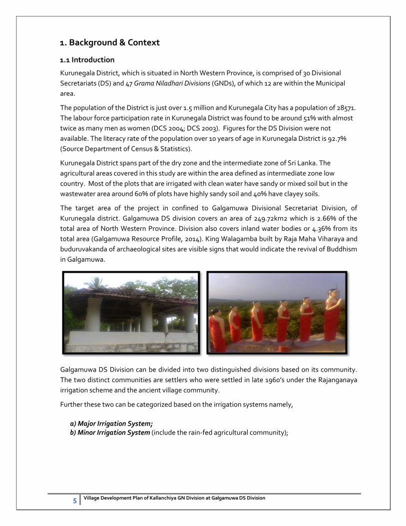
total area (Galgamuwa Resource Profile, 2014). King Walagamba built by Raja Maha Viharaya and
buduruvakanda of archaeological sites are visible signs that would indicate the revival of Buddhism
in Galgamuwa.
Galgamuwa DS Division can be divided into two distinguished divisions based on its community.
The two distinct communities are settlers who were settled in late 1960’s under the Rajanganaya
irrigation scheme and the ancient village community.
Further these two can be categorized based on the irrigation systems namely,
a) Major Irrigation System; b) Minor Irrigation System (include the rain-fed agricultural community);
6 Village Development Plan of Kallanchiya GN Division at Galgamuwa DS Division
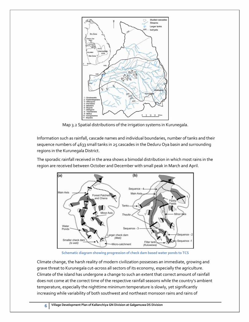
Map 3.2 Spatial distributions of the irrigation systems in Kurunegala.
Information such as rainfall, cascade names and individual boundaries, number of tanks and their
sequence numbers of 4633 small tanks in 25 cascades in the Deduru Oya basin and surrounding
regions in the Kurunegala District.
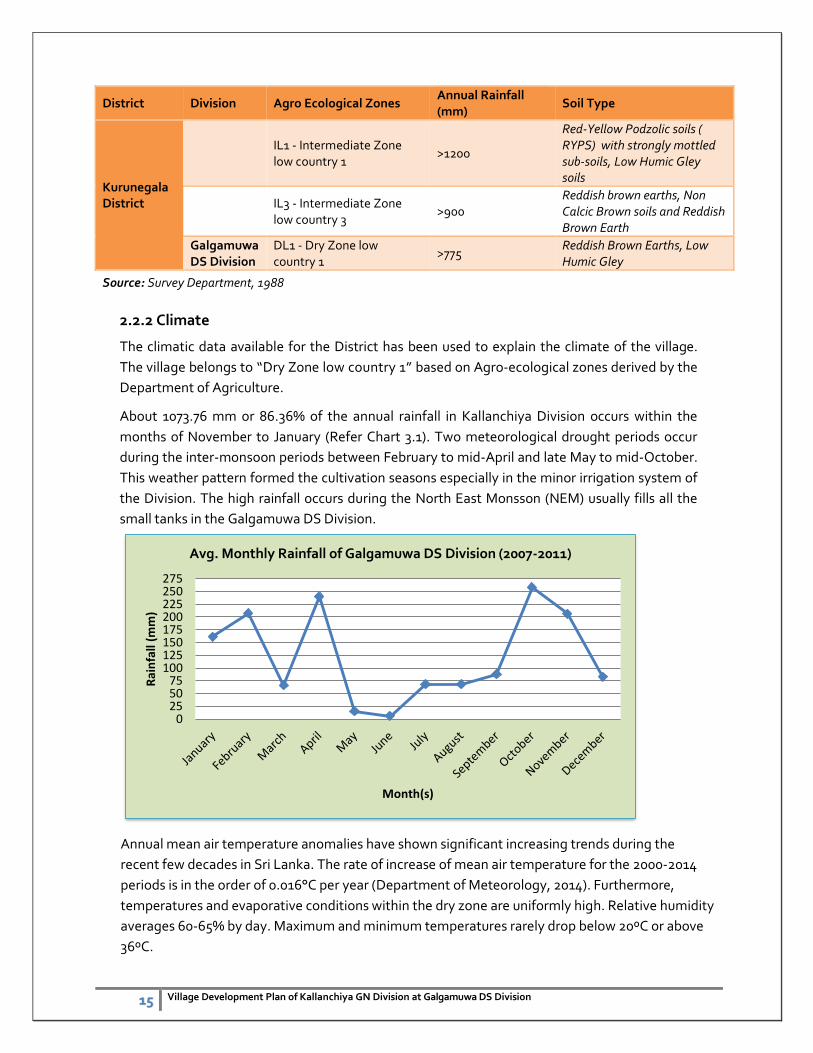
The sporadic rainfall received in the area shows a bimodal distribution in which most rains in the
region are received between October and December with small peak in March and April.
Schematic diagram showing progression of check dam based water ponds to TCS
Climate change, the harsh reality of modern civilization possesses an immediate, growing and
grave threat to Kurunegala cut-across all sectors of its economy, especially the agriculture.
Climate of the island has undergone a change to such an extent that correct amount of rainfall
does not come at the correct time of the respective rainfall seasons while the country’s ambient
temperature, especially the nighttime minimum temperature is slowly, yet significantly
increasing while variability of both southwest and northeast monsoon rains and rains of
7 Village Development Plan of Kallanchiya GN Division at Galgamuwa DS Division
convectional origin (inter-monsoons) has increased significantly during recent decades. As a
result, both extremes, i.e., water scarcity and excess water, have become a recurrent problem in
crop production and its entire value chain in Sri Lanka. Meanwhile recent climatological studies
have revealed that cumulative annual or seasonal rainfall of major climatic zones in Sri Lanka
during last few decades have not under gone a significant change. Nevertheless, occurrence of
heavy rainfall events is on increase during recent times in most parts of the island with web of
negative impacts especially on the agriculture sector. Meanwhile, increasing ambient
temperature is also inflicting several direct and indirect negative impacts on the crop growth.
In order to minimize the impacts of disaster on development and ensure sustainability, it is
necessary to incorporate Disaster Risk Reduction (DRR) and Climate Change Adaptation
(CCA) concerns in to the development programme of the villages. Thus the Ministry of
Disaster Management is encouraging all local planners to prepare Integrated Village
Development Plans (IVDPs) for selected disaster prone villages in the North Western Districts.
The aim of this is to improve the resiliency of the people to minimize the impacts of natural
threats while uplifting the living standard of the people by developing the villages in integrated
manner. This process has been financially assisted by SCCF and technically supported by the
United Nations Development Programme (UNDP) in Sri Lanka.
Based on the selection criteria, five (5) villages in Kurunegala District were selected for the IVDP
process where Kallanchiya Grama Niladari Division (GND) of Galgamuwa Divisional
Secretary Division (DSD) represents one of them.
This plan contains comprehensive information and data of the village together with a series of
digital maps that represent different sectors associate with village development concerns. The
report has twelve (12) chapters describing the situation of the village and highlighting the major
issues related to climate change and disaster risks and recommendations to address these
risks. In addition, approaches to facilitate the Disaster Risk Reduction as well as Climate Change
Adaptation concerns in the development activities have also been discussed and suggested in
this plan.
8 Village Development Plan of Kallanchiya GN Division at Galgamuwa DS Division
1.2 Objectives of the Plan
Main Objective
The main objective of the plan is to mainstream Disaster Risk Reduction concepts in to village
development plan and thereby improve the resilience capacity of vulnerable communities to
minimize the impacts of natural disasters on the economy of the village.
Specific Objectives
1) To identify the impacts of hazards into the development programme in the area
and measures to mitigate the impacts.
2) To identify the possible impacts of the proposed development programmes on
the environment and the possibility of triggering disaster situation and proposed
mitigation activities.
3) To improve the community awareness on mainstreaming disaster risk reduction
components in to village development plan and the contribution of community to
achieve development targets.
1.3 Methodology
1.3.1 Selection of the Village
The disaster profile of the village was considered for the selection. In addition availability of
infrastructure such as roads, drinking water, health services etc. and population were also
considered. District Secretary of Kurunegala District and Divisional Secretary of Galgamuwa
DSD were also consulted to finalize the selection.
1.3.2 Collection of Data
Secondary data was collected from the DS offices and officials specially the Planning unit of
the Secretariat. Key informant survey done together with GN officer of the Kallanchiya
division. Primary data were collected from the village mainly by using Participatory Rural
Appraisal (PRA) method. PRA was used to identify the issues of the village with the
participation of the people of the village, office bearers of the Village Development Society,
Grama Niladari and the officials of the planning branch of the Divisional Secretariat.
Subsequently the identified issues/needs were ranked by the consensus of majority of people
involved in the IVDP process.
In addition the other tools of the participatory approach such as community interviews,
workshops, participatory mapping, seasonal event calendars, transect walk, historical time
line, decision matrix were used when and where ever necessary. A questioner was also used to
collect the necessary data of the village.
9 Village Development Plan of Kallanchiya GN Division at Galgamuwa DS Division
Secondary data were collected from published documents (e.g. Census data) and unpublished
data available with other institutions. Due to unavailability of some secondary data (e.g.
rainfall data) for the village, the data available either for respective Divisional Secretary
Division or for respective District was considered.
Spatial information was collected by three methods i.e. participatory mapping exercise, using
updated maps and using recent satellite images. The final computer generated maps were
prepared using mapping software namely QGIS.
Kllanchiya GN Division
Kallanchiya Village
10 Village Development Plan of Kallanchiya GN Division at Galgamuwa DS Division
2. General Information
2.1 General Description of the Village
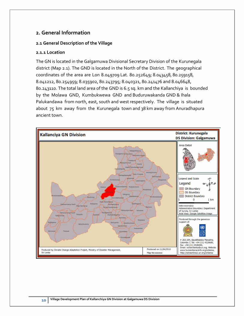
2.1.1 Location
The GN is located in the Galgamuwa Divisional Secretary Division of the Kurunegala
district (Map 2.1). The GND is located in the North of the District. The geographical
coordinates of the area are Lon 8.049709 Lat. 80.252649; 8.043458, 80.259158,
8.041212, 80.254959; 8.035902, 80.243795; 8.040321, 80.241476 and 8.046648,
80.243110. The total land area of the GND is 6.5 sq. km and the Kallanchiya is bounded
by the Molawa GND, Kumbukwewa GND and Buduruwakanda GND & Ihala
Palukandawa from north, east, south and west respectively. The village is situated
about 75 km away from the Kurunegala town and 38 km away from Anuradhapura
ancient town.
11 Village Development Plan of Kallanchiya GN Division at Galgamuwa DS Division
2.1.2 Historical Background
The Kallanchiya GND had been established in 1989 which was detached from
Mahagalkadawala division and the entire population of the village is 663 consisted with
Sinhala. The people of the village were continuously affected by the prolonged dry conditions
annually and affected my marked depreciations due to various adverse conditions. Total
population mainly relied on agri-based livelihoods however few government workers are also
representing the village.
2.1.3 Cultural Features
There are some special cultural features in the village but most of the places are not
clearly identified by the respective departments but Buduruwakanda temple is the one
evidence for that.
2.1.4 Population
The population density of the Kallanchiya GN Division is 642.8ha people in sq. km. (Map 2.2).
The total population of the village is 663 (Village Resource profile, 2014). The total number of
families is 227.
2.1 Location Map of the Kallanchiya GND
12 Village Development Plan of Kallanchiya GN Division at Galgamuwa DS Division
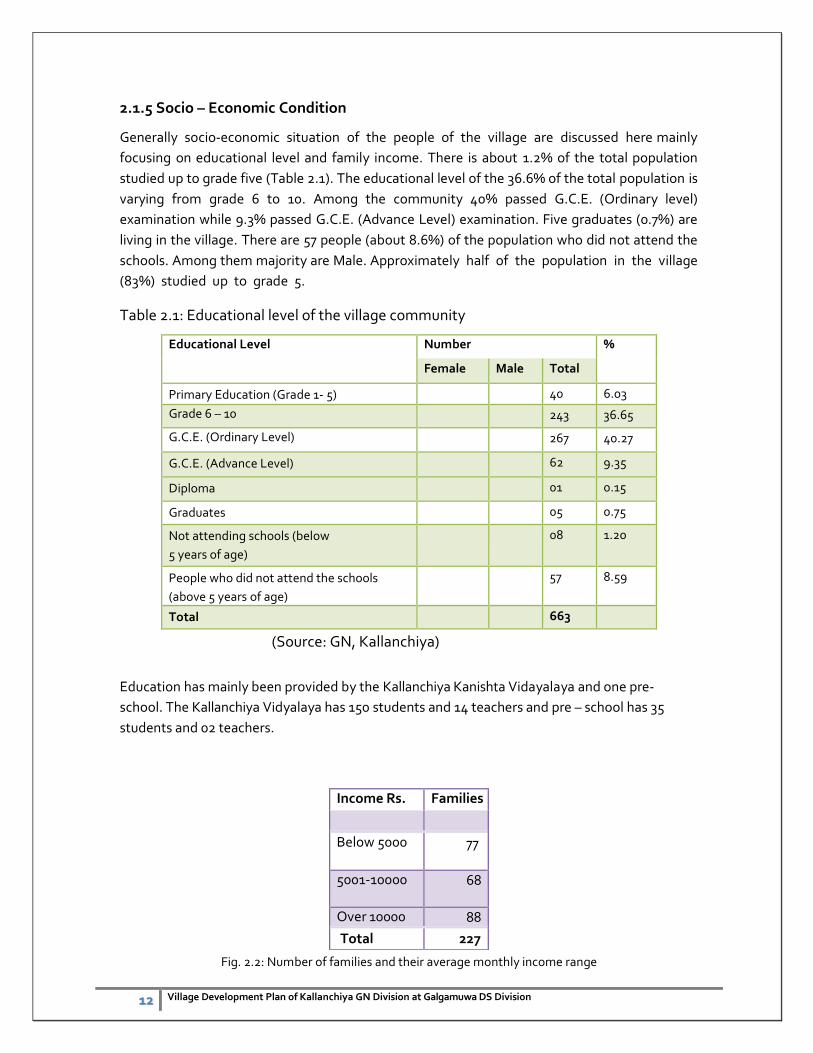
2.1.5 Socio – Economic Condition
Generally socio-economic situation of the people of the village are discussed here mainly
focusing on educational level and family income. There is about 1.2% of the total population
studied up to grade five (Table 2.1). The educational level of the 36.6% of the total population is
varying from grade 6 to 10. Among the community 40% passed G.C.E. (Ordinary level)
examination while 9.3% passed G.C.E. (Advance Level) examination. Five graduates (0.7%) are
living in the village. There are 57 people (about 8.6%) of the population who did not attend the
schools. Among them majority are Male. Approximately half of the population in the village
(83%) studied up to grade 5.
Table 2.1: Educational level of the village community
Educational Level Number %
Female Male Total
Primary Education (Grade 1- 5) 40 6.03
Grade 6 – 10 243 36.65
G.C.E. (Ordinary Level) 267 40.27
G.C.E. (Advance Level) 62 9.35
Diploma 01 0.15
Graduates 05 0.75
Not attending schools (below
5 years of age)
08 1.20
People who did not attend the schools
(above 5 years of age)
57 8.59
Total 663
(Source: GN, Kallanchiya)
Education has mainly been provided by the Kallanchiya Kanishta Vidayalaya and one pre-
school. The Kallanchiya Vidyalaya has 150 students and 14 teachers and pre – school has 35
students and 02 teachers.
Fig. 2.2: Number of families and their average monthly income range
Income Rs. Families
Below 5000 77
5001-10000 68
Over 10000 88
Total 227
13 Village Development Plan of Kallanchiya GN Division at Galgamuwa DS Division
Based on the available information, monthly income of the families is indicating the income of
the 88 families is varying from Rs. 10,000 to 15,000 due to the majority of the community
members’ depends on agriculture production. In other hand 34% of the families are earn
less than Rs.5000. per month (Fig. 2.2). Therefore, increase the family income is crucial in these
families to uplift the living standard of the people and thereby improving the disaster resilience
capacity of them. The present income generating activities are varying and given in the Table
2.2.
Table 2.2: Number of individuals and their income generating activities.
Income generating activity Number of people engaged %
Labour works 18 4.9
Agriculture 230 62.8
Self-employments 14 3.8
Government jobs 55 15
Private sector jobs 32 8.7
Foreign 17 4.6
Total 366
It is important to explore the ways and means to increase the income by present activities and
also find out new avenues for the income generation. Majority of the people live with
Agriculture. There are 62.8% people earn their income from agriculture mainly from paddy and
chena cultivation. Labor works is the income source of 18 people in the village. Self-
employments are being done by 14 people that include running groceries, carpentry and
masonry works. Apparently there is a potential to develop the agricultural activities to increase
the income of the families. The possibility of the introduction of Aquatic fisheries in these tanks
needed to be examined. The issues regarding the agriculture should be addressed to develop
minor irrigation tank and canal system. Increase productivity there by attracts more people for
paddy cultivation and chena cultivation. Since fruits like mango, oranges and wood apple are
available during the season, possibility of starting an industry has to be identified.
However 110 people are unemployed based on thee recent survey by the GN officer. There are
75 families receiving “Samurdi” benefits and majority of them (52 families) receiving Rs.
1500.00 per month.
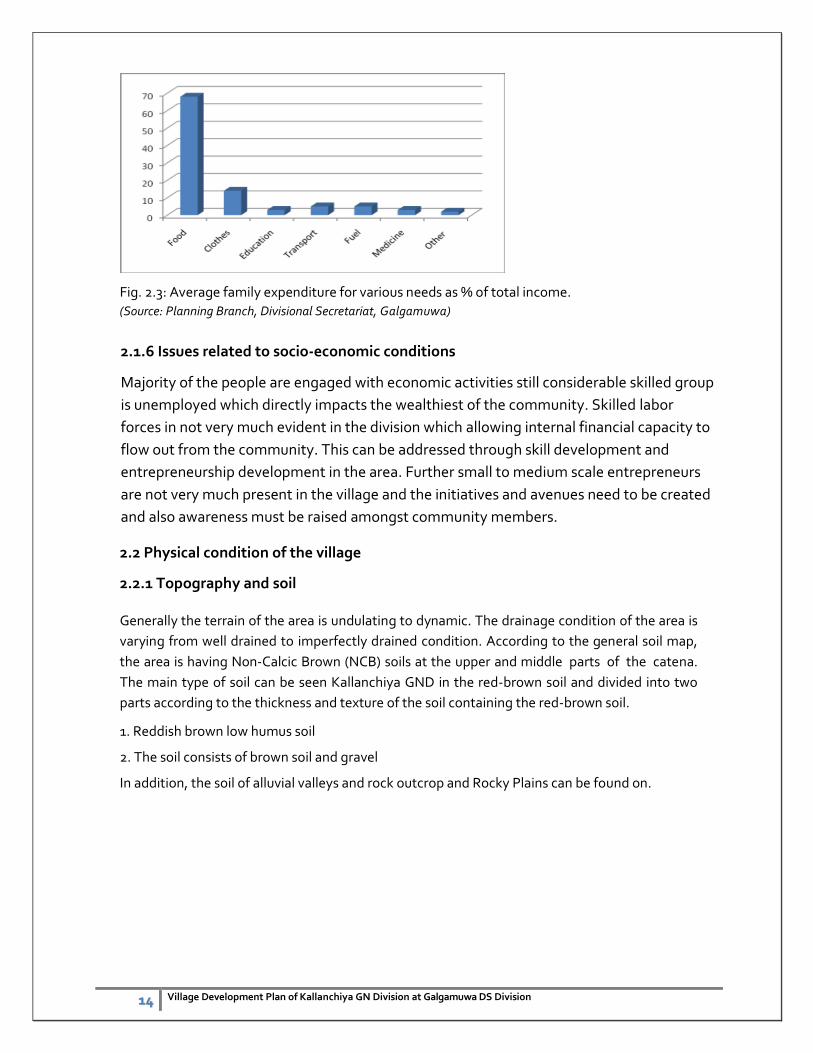
Average expenditure pattern of the family show that they expend about 65% from their
income for foods. For clothes they expend about 9% and less than 10% expend for education,
transport, fuel and medicines (Fig. 2.3). There is a possibility to reduce the expenditure for
food by developing the agriculture particularly by developing home gardens.
14 Village Development Plan of Kallanchiya GN Division at Galgamuwa DS Division
Fig. 2.3: Average family expenditure for various needs as % of total income.
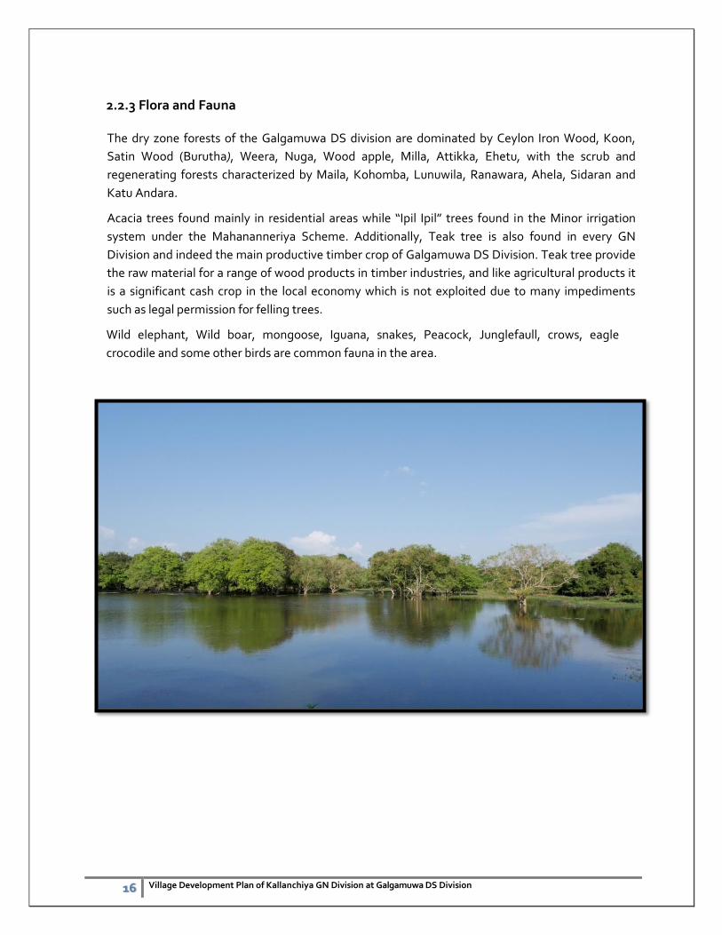
crocodile and some other birds are common fauna in the area.
17 Village Development Plan of Kallanchiya GN Division at Galgamuwa DS Division
3. Natural Resources
The village is rich in terms of availability of Natural Resources. Forest and Mineral resources are
available in this village. People of the village obtain drinking water from dug wells and
shallow wells, water streams. The water resources of the village have been discussed in Chapter
seven.
The Kallanchiya Division includes dry zone forests at certain in the minor irrigation system. Forest
is an important natural resource in Galgamuwa DS vision for a number of reasons. Amongst
benefits they can be an important source of income, help maintain biodiversity by providing a
range of habitats for animals, provide shade and help to protect the soil. Some of these advantages
are directly linked to livelihood activities in both irrigation systems whereas others, such as
maintenance of biodiversity, are indirect. Further, trees also an important asset in these forests.
Galgamuwa Forest Reservation is more than 12,000 acres which include dry zone forest and the
introduced Eucalyptus tree plantations.
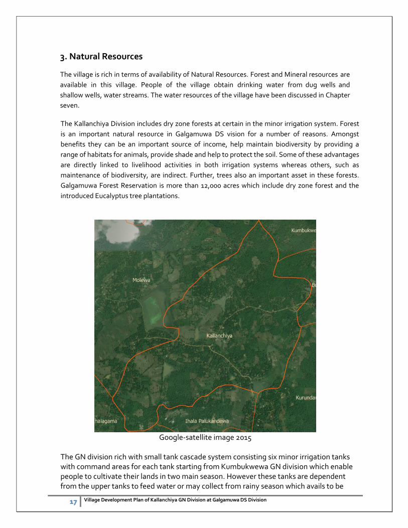
Google-satellite image 2015
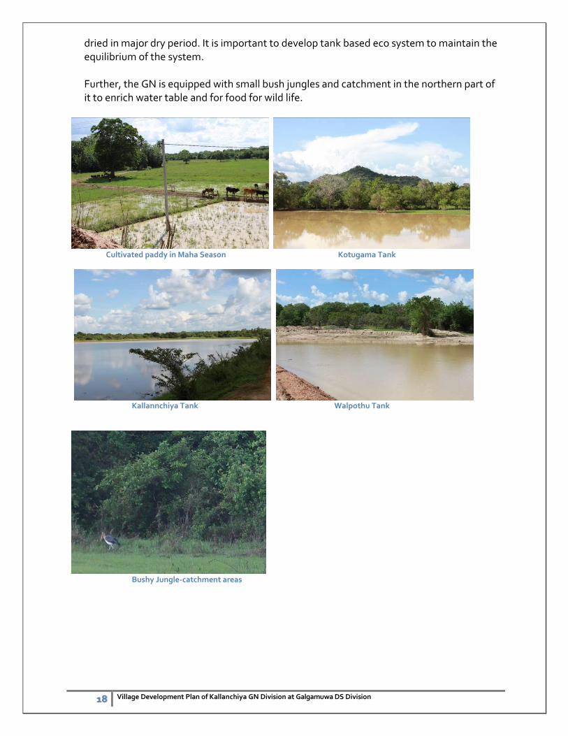
The GN division rich with small tank cascade system consisting six minor irrigation tanks with command areas for each tank starting from Kumbukwewa GN division which enable people to cultivate their lands in two main season. However these tanks are dependent from the upper tanks to feed water or may collect from rainy season which avails to be
18 Village Development Plan of Kallanchiya GN Division at Galgamuwa DS Division
dried in major dry period. It is important to develop tank based eco system to maintain the equilibrium of the system.
Further, the GN is equipped with small bush jungles and catchment in the northern part of it to enrich water table and for food for wild life.
Cultivated paddy in Maha Season Kotugama Tank
Kallannchiya Tank Walpothu Tank
Bushy Jungle-catchment areas
19
4. Land Use Pattern
Out of the total of 642.5ha, the dominant land use of the village is forest (35%) (Map4.1). The
total extent of the paddy fields is 133 ha. Rest of the land has mainly been used for homesteads
(224.8 ha), Chena (1ha.) and also covered by scrub (2.5ha) and water bodies (205 ha). 12ha
also belongs to the Government which is being used for Schools, health center, community
center etc.
Map 4.1: Land use of Kallanchiya GN Division
4.1 Lad use issues Land use regulations are not followed by the villagers as habitats are created in the catchment areas of tank cascade. However major distortion of jangle is not visible as some chena cultivation can be seen. Bio diversity conservation practices must enhance in the division and also safe livelihood options to be explored.
20
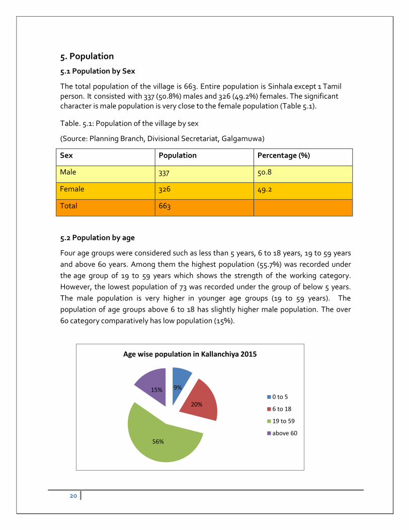
5. Population
5.1 Population by Sex
The total population of the village is 663. Entire population is Sinhala except 1 Tamil person. It consisted with 337 (50.8%) males and 326 (49.2%) females. The significant character is male population is very close to the female population (Table 5.1).