Chapter 4: Local Plans Chapter 4, page 352a Rochedale Urban Community Local Plan 1 Introduction This Local Plan contains specific additional local planning requirements. Where it conflicts with the requirements of the City Plan, this Local Plan prevails. In using this Local Plan, reference should also be made to Section 1.1—Using a Local Plan at the front of this chapter. Non–Statutory Guidance Note The data available indicates the area covered by this Local Plan was not subject to inundation during the January 2011 flood. Notwithstanding the Queensland Floods Commission of Inquiry is investigating the flood disaster, including the review of the existing town planning provisions related to flood and flood risk mitigation. Brisbane City Council is also undertaking separate investigations into the flooding. The findings of Council’s investigations and the final report of the Commission may recommend changes to City Plan, including this local plan, and the State Planning Policy. Consequently, the provision of this local plan with the respect to the management of flooding and flood risk management may be subject to change at the direction of the Queensland Government or Brisbane City Council in the near future. This should be taken into account by applicants and assessment managers when considering development in this local plan area. Applicants are advised to make relevant enquiries regarding the status of the provisions relating to flooding. 2 Development principles The Rochedale Urban Community (‘Rochedale’) will be developed as an integrated and master planned urban community with a mix of uses. These will include a range of residential, commercial, industrial, community and educational uses. 2.1 Rochedale will be mainly comprised of residential areas in a series of neighbourhoods, each with a neighbourhood centre that acts as a focal point. There will be a mix of residential types, sizes, tenure and densities providing housing choice and affordability for all stages of the life cycle to meet diverse community needs. Affordable housing will be encouraged through development bonuses. The interface between higher densities and lower densities will be managed through building heights decreasing with increasing distance from centres and major roads. 2.2 The range of commercial areas will maximise the opportunities for local employment, to provide superior business settings and cluster compatible businesses and services. 2.3 Sustainable, subtropical design principles will be reflected through the design of neighbourhoods, building siting and design, construction and management. Development will result in landscapes that contribute to subtropical design and lifestyle. Street trees will provide shade and landscape amenity for the community. 2.4 Development will incorporate innovative integrated water management strategies which contribute to making Rochedale water efficient. Brisbane City Plan — Volume 1 Rochedale Urban Community Local Plan Amended 18 November 2011
Transcript
Cha
pter
4: L
ocal
Pla
ns
Chapter 4, page 352a
Rochedale Urban Community Local Plan
1 Introduction
This Local Plan contains specific additional local planning requirements. Where it conflicts with the requirements of the City Plan, this Local Plan prevails.
In using this Local Plan, reference should also be made to Section 1.1—Using a Local Plan at the front of this chapter.
Non–Statutory Guidance Note
The data available indicates the area covered by this Local Plan was not subject to inundation during the January 2011 flood. Notwithstanding the Queensland Floods Commission of Inquiry is investigating the flood disaster, including the review of the existing town planning provisions related to flood and flood risk mitigation. Brisbane City Council is also undertaking separate investigations into the flooding. The findings of Council’s investigations and the final report of the Commission may recommend changes to City Plan, including this local plan, and the State Planning Policy.
Consequently, the provision of this local plan with the respect to the management of flooding and flood risk management may be subject to change at the direction of the Queensland Government or Brisbane City Council in the near future. This should be taken into account by applicants and assessment managers when considering development in this local plan area. Applicants are advised to make relevant enquiries regarding the status of the provisions relating to flooding.
2 Development principles
The Rochedale Urban Community (‘Rochedale’) will be developed as an integrated and master planned urban community with a mix of uses. These will include a range of residential, commercial, industrial, community and educational uses.
2.1 Rochedale will be mainly comprised of residential areas in a series of neighbourhoods, each with a neighbourhood centre that acts as a focal point. There will be a mix of residential types, sizes, tenure and densities providing housing choice and affordability for all stages of the life cycle to meet diverse community needs. Affordable housing will be encouraged through development bonuses. The interface between higher densities and lower densities will be managed through building heights decreasing with increasing distance from centres and major roads.
2.2 The range of commercial areas will maximise the opportunities for local employment, to provide superior business settings and cluster compatible businesses and services.
2.3 Sustainable, subtropical design principles will be reflected through the design of neighbourhoods, building siting and design, construction and management. Development will result in landscapes that contribute to subtropical design and lifestyle. Street trees will provide shade and landscape amenity for the community.
2.4 Development will incorporate innovative integrated water management strategies which contribute to making Rochedale water efficient.
2.5 Connectivity to key destinations will be achieved through a highly accessible and interconnected transport network. Active lifestyles will be supported through creating opportunities for walking and cycling in preference to motorised transport. An active transport network and an integrated public transport system will provide convenient connections between activity centres and residential neighbourhoods.
2.6 The natural ecological, waterway and open space systems are to be maintained and enhanced. The protection of koala habitat and wildlife movement corridors is also essential.
2.7 Rochedale will be a vibrant, inclusive and accessible community. A strong sense of community will be provided through a range of cultural, social service, education, sport and recreational facilities.
2.8 Rochedale will be provided with adequate, high quality urban standard infrastructure in a timely and efficient manner that does not cause environmental harm.
2.9 R o c h e d a l e w i l l p r o v i d e h i g h – s p e e d telecommunications infrastructure for its worker and resident populations.
3 Elements
Refer to Section 4.2—Elements, at the front of the Local Plans for Outer Suburbs section of this Chapter, for general guidance on the intent for the different elements of the Local Plan as indicated on Map A—Elements and Map B—Movement, Waterway Systems and Koala Habitat. The following text provides locally specific information regarding these elements that is to be considered in addition to the general requirements for Local Plans for Outer Suburbs. As discussed in Section 4.2, these elements are to be read as being part of the Local Plan Code.
3.1 Koala Habitat Areas
All land within Rochedale is subject to the Nature Conservation (Koala) Conservation Plan 2006 and Management Program 2006–2016 (the Koala Plan). Under the Koala Plan, land within Rochedale is mapped as an Urban Koala Area or Koala Conservation Area as shown in Map B—Movement, Waterway Systems and Koala Habitat. The Koala Plan requires development complies with the relevant koala conservation criteria, which are in addition to the requirements of the Local Plan.
Development that reduces koala habitat as identified in Map B—Movement, Waterway Systems and Koala Habitat will be required to provide consolidated supplementary planting within the site or elsewhere within Rochedale.
3.2 Environmental and scenic constraints
3.2.1 Habitat areas and ecological corridors
Bulimba Creek is a wildlife corridor of regional significance which adjoins the western boundary of Rochedale. Development within Rochedale will protect this corridor through buffering and integrated water management.
The habitat areas and ecological corridors parallel to the Gateway Motorway are important north to south ecological links which will buffer Bulimba Creek from future development. Development is to protect and enhance the ecological values of the corridor. Through the land development process, most land within this corridor is to be rehabilitated and transferred into public ownership. Once transferred, this corridor will be included in the Conservation Area.
An inter–connected east–west fauna movement corridor is to be created that links the Leslie Harrison Dam catchment with Bulimba Creek through the Prebble Street underpass. Development is to retain and enhance the ecological values of this area. The corridor will comprise core waterway corridors, fringe waterway corridors, habitat areas and ecological corridors—public and habitat areas and ecological corridors—private. Map A—Elements shows the location of this corridor.
Development adjacent to and including this area is to occur in conjunction with a structure plan and revegetation plan that demonstrates the establishment and protection of the East–West fauna corridor. Large lots with clearly defined development footprints will be provided on land that will support this corridor. Revegetation is to use locally endemic species to re–establish habitat commensurate with the pre–clearing regional ecosystem. The retention of significant vegetation is to enhance landscape amenity. Development adjoining the District Sports Park will be connected and oriented to the park.
The land identified as ‘Rural with habitat and ecological values’ or Environmental Protection in the eastern part of Rochedale is part of the Regional Landscape and Rural Production Area under the South East Queensland Regional Plan. Subdivision is not appropriate in this area.
3.2.2 Waterway corridor
The core and fringe waterway corridors are located along the existing creek networks of Rochedale and provide for multi–functional uses. Some waterways provide key east–west linkages between Bulimba Creek and the Leslie Harrison Dam catchment.
The core waterway corridor provides for water conveyance, protection of waterway health, wildlife C
movement, vegetation protection, urban amenity and low impact recreation. This will be achieved through rehabilitation of these corridors.
The fringe waterway corridor is either side of the core waterway corridor and protects the core waterway corridor from adverse impacts. The fringe waterway corridor provides for pedestrian/cycle movement, boulevard roads, essential infrastructure, and where shown, local parks.
The waterway corridors that will function as key water conveyance infrastructure are to be transferred to Council as development occurs. Other waterway corridors are to remain in private ownership and some will be managed through easements and covenants. To ensure acceptable stormwater outcomes, these easements and covenants are to accommodate stormwater flows from a fully developed catchment. Map B indicates the intended ownership of waterway corridors.
Development is not to occur within the core waterway corridor.
3.2.3 Environmental protection
This land is to be protected from urban development as it supports significant vegetation, provides key fauna habitat or functions as a strategic fauna movement corridor. Land in the eastern part of Rochedale is also within the Leslie Harrison Dam catchment. City Plan provisions for the Environmental Protection Area apply in this element together with relevant legislative requirements for the protection of koalas and other native flora and fauna.
3.3 Open space and parks
The two proposed district sports parks with co–located community facilities will provide for a range of indoor and outdoor sports, informal recreation and community activities. City Plan provisions for the Sport and Recreation Area apply to district sports parks.
The local park network will be located within 400 metres of the majority of dwellings and, where possible, will link to the waterway corridors. Water quality/quantity treatment devices within parks will only be supported where provided in accordance with the Local Plan Code.
The northern district sports park and local parks form part of the east–west fauna corridor. Treatment of existing vegetation and proposed landscaping will reflect this function.
Existing vegetation in parks is retained to provide amenity as well as retain elements of the Rochedale cultural landscape. Opportunity exists for the re–alignment of the local park to the south–east of the
Rochedale and Ford Road intersection to include an existing mature orchard.
Enhancement of parks is to accommodate and encourage a broad range of recreation activities required by the diverse Rochedale community.
3.4 Potential development areas
Refer to Map A—Rochedale Urban Community Local Plan—Elements
3.4.1 Very low density residential
This land comprises predominantly houses situated within building plans located to protect and strengthen the ecological values of the precinct. This land will have a yield of 5 dwellings per hectare and a minimum lot size of 2,000m2. Reconfiguration to create smaller lots may be supported where it can be demonstrated that a better ecological outcome will be achieved and provided that the semi–rural, open space character of the area will not be compromised.
3.4.2 Low density residential
This land predominantly comprises a mix of lot sizes for detached houses with a yield of 14 dwellings per hectare. Land located adjoining the low–medium density residential potential development area, within a 400m walkable catchment of local neighbourhood centres lot boundaries or facing onto local parks will support multi–unit dwellings with a yield of 16 dwellings per hectare. Affordable housing will be encouraged.
3.4.3 Low–medium density residential
This land comprises a mix of houses and multi–unit dwellings at a yield of 16–25 dwellings per hectare. Aged care accommodation and affordable housing will be supported near neighbourhood centres and the Town Centre.
3.4.4 Mixed use
This land comprises predominantly higher density multi–unit dwellings located around the Town Centre Precinct, neighbourhood centres and busway stations. Some small scale commercial activities will be acceptable, where they are compatible with the residential nature of the area.
These commercial uses will be on the ground and lower levels of a multi–unit dwelling, or may be accommodated within the same site in a separate building. Affordable housing will be encouraged. The mixed use precinct around the Town Centre will have a yield of 50 dwellings per hectare and the two other
mixed use precincts at Underwood Road and at the intersection of Miles Platting Road and Rochedale Road will have a yield of 40 dwellings per hectare.
3.4.5 Centres
3.4.5.1 Town Centre
This land is to be the main commercial centre for the Rochedale community and is to have the role and function of a Suburban Centre (MP3). It is the central location for retail, community, business and commercial uses in Rochedale. The Town Centre will contain at least one supermarket and supporting shops, as well as business or office uses. Additional facilities such as health and medical services, and gymnasium/health centre, will also be encouraged to locate within the Town Centre, providing residents with local services as well as adding to the centre’s vitality.
The Centre will also provide centrally located bus stops and will be the focus of active and public transport in Rochedale. Residential development will be supported and low income affordable housing will be encouraged.
The Town Centre itself will have a sense of place featuring a town square, flanked by buildings with community facilities, restaurants and cafes, with a strong link to a town park and nearby waterway corridor. The Town Centre may be developed in stages until the ultimate development is realised.
The Town Centre will be a compact centre with active streetscapes and pedestrian environments not dominated by carparking. It will provide clear access including the provision of a town centre main street, vistas and focus to the nearby town park and waterway corridor to the west of the Town Centre. Refer to Figures a, b and c which reflects design principles for how the Town Centre should ultimately develop. These include the relationship between the town park, community facilities and surrounding uses, the location of active frontages and the function and format of the main street.
Through traffic will be discouraged from using the main streets through appropriate measures that limit vehicle speed and restricting the road to two lanes of moving traffic. The provision of landscaping and kerb side parking will also assist in achieving a pedestrian friendly main street. All carparking should be accessed via internal Town Centre roads, not from Miles Platting or Gardner Roads.
The Town Square is the pre–eminent civic space within Rochedale and will perform a vital role in facilitating community interaction. The Town Square will be a versatile space which allows for a variety of uses such as community markets and gatherings.
Unrestricted community access is required to promote a sense of community ownership. To achieve this outcome, the Town Square should be dedicated to Council for public ownership.
3.4.5.2 Neighbourhood and business service centres
These centres are located to best service the convenience needs of the surrounding community. The neighbourhood centres are to have the role and function of a convenience centre (MP4). Map A indicates the location for these centres and allows flexibility in siting where two corner locations are shown. One of the corner sites will be developed as a single, consolidated centre. The remaining corner site will be developed in character with the adjoining land uses. The maximum gross floor area of each Neighbourhood and Business Service Centre is 1,500m2 for each centre. Full line supermarkets, discount department stores and retail/bulky goods warehousing are not appropriate in these precincts.
These centres will provide strong links with the pedestrian and cycle networks and parks (where applicable) and surrounding residential precincts. Parks that adjoin a centre will provide a focus and orientation for the centre.
Neighbourhood centres are small convenience centres that provide local services to the surrounding residential neighbourhoods. These services include shops, restaurants and supporting community uses and child care facilities.
Business service centres are small convenience centres that provide local services to the surrounding business community. These services include small food outlets, support office uses for businesses and limited retail. Child care facilities are not considered compatible with these centres because of their close proximity to the landfill site.
3.4.5.3 Business Park and Gateway Civic
These precincts accommodate specialised employment opportunities within Rochedale.
The Business Park forms a buffer area between the Rochedale landfill, the Future Industry area and residential areas. It is to accommodate high amenity and low impact industry. Ancillary uses such as cafes will be supported. Stand alone office or retail uses are inappropriate in this area.
A convention centre will be encouraged adjoining the Business Service Centre and waterway. Stand alone child care facilities are not appropriate in this element due to its proximity to the landfill. However, small scale child care facilities that can provide adequate space and
provision of equipment which allow for active play may be supported where they are ancillary to and integrated with an industry use on the same site.
The Gateway Civic precinct is in a visible location near the motorways that will have signature buildings that act as a gateway into Rochedale. It will accommodate offices and related educational facilities. This is the only precinct where a service station is appropriate.
3.4.5.4 Proposed busway station
This land is intended to accommodate a future busway station. Some commercial development, primarily serving the convenience needs of busway patrons, will be supported as part of the initial development of the land for a busway station. The preferred longer term development option is for an integrated mixed use precinct incorporating a component of retail, higher density residential, including elements of affordable housing, and high quality office uses. Full line supermarkets (anything more than 1,000m² or more than one supermarket activity), discount department stores and retail/bulky goods warehousing are not appropriate in this precinct.
This form of development will be supported on the busway station site, and subject to further investigation, may be supported within a 400m radius of the busway station. Any interim land use within this radius must not prejudice the achievement of this preferred future land use option. Any future development must not challenge the retail primacy of the Town Centre within Rochedale and be compatible with surrounding land uses.
3.4.5.5 Community uses
The existing community uses located on Rochedale Road create the opportunity to provide a strong community and educational precinct. The additional land adjoining Redeemer Lutheran College will allow uses such as schools, training, community facilities and child care facilities.
Community Uses will be integrated with the Town Centre to provide uses such as public meeting places, public halls and a youth activity centre and a child care facility.
The retention and use of the existing community facilities for a range of uses will be encouraged.
3.5 Movement system
Where safe traffic operation allows, direct lot access will be encouraged to create active frontages and social interaction, streetscape amenity and safety. Direct lot access is not appropriate on the major roads. The existing and proposed road and pedestrian/cycle network is
indicated is shown on Map B—Rochedale Urban Community Local Plan—Movement, Waterway Systems and Koala Habitat.
The focus of the public transport system in Rochedale will be the Town Centre, however the further development of the South East Busway is likely to create a new busway station on Underwood Road. This will provide an opportunity for the surrounding community to receive a much higher level of service.
Council requires the provision of a pedestrian/cycle link generally south of Glenmore Crescent and the waterway to facilitate pedestrian movement between the future busway and district sports park. The linkage can be achieved through local access roads and provide opportunities for additional linkages to St Joseph’s Primary School and Redeemer Lutheran College.
Where roads intersect habitat areas and ecological corridors and waterway corridors they are designed to incorporate wildlife movement infrastructure to facilitate the safe movement of fauna. The desired locations of wildlife movement infrastructure are indicated on Map B.
Land to the east of Rochedale around Ford, Alperton and Kloske Roads supports valued wildlife. The road network must be designed to direct through traffic away from this area.
The enhancement of movement system connectivity between Rochedale and communities to the west should be considered in future movement system planning for the area. In particular, improved public and active transport connections are strongly encouraged. Enhancements to the general road system should focus on improving network efficiency and capacity along existing road corridors such as Mt Gravatt–Capalaba and Miles Platting Roads.
3.6 Infrastructure
Adequate, high standard urban infrastructure is to be provided to the potential development area. This infrastructure is to be provided in a timely and efficient manner in accordance with Council’s applicable infrastructure planning instrument.
3.7 Integrated water management
Rochedale is to incorporate innovative integrated water management strategies to minimise water demand, promote the efficient use of water assets and enhance waterway health. Dual reticulation, rainwater tanks and water sensitive urban design measures such as swales are critical components of this strategy. All development must provide a Site Based Stormwater Management Plan demonstrating compliance with the Stormwater Management Code and Subdivision and Development Guidelines provisions.
The long term intention for the Landfill site is for it to continue operation. Options for the site following the end of landfill activities include a metropolitan park.
3.9 Future Industry (Brickworks)
Development of the site is to involve the rehabilitation of waterway corridors.
3.9.1 Future Industry
City Plan provisions for the Future Industry Area apply in this element. It is anticipated that general to light industry will locate on this site however an industrial structure plan will be required to be submitted as part of any application. Development will be required to provide a recreation space appropriate for use by the site’s worker population.
Development must take into consideration the site’s proximity to Bulimba Creek and its strategic role in forming part of the north–south fauna corridor.
4 Level of assessment
The following tables contain exceptions to the level of assessment, overriding the levels of assessment in Chapter 3.
Development in the potential development area will be regarded as if it were occurring in the Emerging Community Area and will be assessed against the Emerging Community provisions of Chapter 3 subject to the variations included in this Local Plan’s Level of Assessment table.
Areas within the Local Plan boundary but outside of the Potential Development Area will be assessed against their current classification contained in Chapter 3.
Development in the Future Industry Area will be regarded if it were occurring in the Future Industry Area and will be assessed against the Future Industry provisions of Chapter 3.
A preliminary approval may change the level of assessment identified in these tables. The trigger for assessment in the Level of Assessment tables is material change of use and/or building work (associated with a use or structure specified in the level of assessment tables) unless otherwise specified.
• for premises located partly in the Potential Development Area and partly outside the Potential Development Area; or
• creating a single lot in that part of the premises located inside the Potential Development Area or opening a public road, or dedication of land to Council for public purposes; and
• demonstrates compliance with the Rochedale Local Plan Code’s Acceptable Solutions A3.1 and A5.1
Rochedale Local Plan Code and Subdivision Code
4.2 Very–low density residential element
Code Assessment Applicable Codes
Notifiable
1. Reconfiguration of a lot where wholly within the potential development area and where:
• complying with Acceptable Solutions A3.1 and A17.1
Rochedale Local Plan Code and Subdivision Code
Impact Assessment Relevant Codes
Generally inappropriate
2. Multi–unit dwelling
3. Single–unit dwelling
4. Reconfiguration of a lot, creating a lot/lots smaller than 2,000m2
4.3 Low density residential element
Self Assessment Applicable Codes
1. House where:
• complying with acceptable solutions in the House Code (whether or not involving extensions or renovations exempt from assessment against the Residential Design—Small Lot Code)
• for a new house, complying with acceptable solution A16.1
Rochedale Local Plan Code and House Code
2. House where:
• on a lot less than 450m² or with an average width of less than 15m or on a rear lot less than 600m² (excluding access way); and
• complying with the acceptable solutions in Part 1 of the Residential Design—Small Lot Code; and
• for a new house, complying with acceptable solution A16.1
Rochedale Local Plan Code, House Code and Residential Design—Small Lot Code
3. Reconfiguration of a lot where wholly within the potential development area and where:
• complying with acceptable solutions A3.1 and A5.1
Rochedale Local Plan Code and Subdivision Code
4. Reconfiguration of a lot where wholly within the potential development area and for dual oc-cupancies in the low–density residential element and where:
• complying with acceptable solutions A3.1 and A19.1
Rochedale Local Plan Code and Subdivision Code
5. Multi–unit Dwelling where:
• involving no more than two dwelling units• complying with the Rochedale Local Plan
Code’s acceptable solution A19.1
Rochedale Local Plan Code and Residential Design—Low Density, Character and Low–medium Density Code
Impact Assessment Relevant Codes
Generally appropriate
1. Multi–unit dwelling where:
• complying with the Rochedale Urban Community Local Plan Code’s Acceptable Solutions A18.1 and A21.1
Rochedale Local Plan Code and Residential Design—Low Density, Character and Low–medium Density Code
4.4 Low–medium density residential elementSelf Assessment Applicable Codes
1. House where:
• complyingwithacceptablesolutionsintheHouse Code (whether or not involving extensions or renovations exempt from assessment against the Residential Design—Small Lot Code) and
• in accordance with the Acceptable Solutions for gross floor area, building setback and building height of the Residential Design—Low Density, Character and Low–medium Density Code; and
• complies with the Rochedale Local Plan Code’s Acceptable Solution A18.1
Rochedale Local Plan Code and Residential Design—Low Density, Character and Low–medium Density Code
4.5 Mixed use elementCode Assessment Applicable Codes
1. Non–residential Centre Activities where:
• combined with a Multi–unit dwelling and where the non–residential Centre Activities are located on the ground floor; and
• the total centre activities (other than a Multi–unit dwelling or short term accommodation) are not greater than 30% of the gross floor area of the buildings on site; and
• for development in the Mixed use element around the Town Centre and near the intersection of Gardner Road and Miles Platting Road, complies with the Rochedale Local Plan Code’s Acceptable Solutions A23.1, A24.2 and A25.2; or
• for development in the Mixed use element at Underwood Road and the intersection of Miles Platting Road and Rochedale Road, complies with the Rochedale Local Plan Code’s Acceptable Solutions A23.1, A24.2 and A27.1
Rochedale Local Plan Code, Centre Design Code, Centre Amenity and Performance Code and Residential Design—Medium Density Code
2. Multi–unit Dwelling where:
• in accordance with the gross floor area, building setback and height provisions of the Rochedale Local Plan Code and the Residential Design—Medium Density Code; and
• for development in the mixed use element around the Town Centre and near the intersection of Gardner Road and Miles Platting Road, complies with the Rochedale Local Plan Code’s Acceptable Solutions A18.1, A23.1, A24.2 and A25.2; or
• for development in the Mixed use element at Underwood Road and the intersection of Miles Platting Road and Rochedale Road complies with the Rochedale Local Plan Code’s Acceptable Solutions A18.1, A23.1, A24.2 and A27.1
Rochedale Local Plan Code and Residential Design—Medium Density Code
1. Industry where: for scientific or technological research, investigation or testing and not identified in Schedule 1 or 2 of Industrial Areas in Chapter 3 where:
• complying with Acceptable Solution A45.1
2. Convention Centre where:
• complying with Acceptable Solution A45.2
Rochedale Local Plan Code, Industrial Amenity and Performance Code, Industrial Design Code and Energy Efficiency Code
Impact Assessment Relevant Codes
Generally appropriate
3. Convention Centre where:
• notcomplyingwithA45.2
4. Educational Purposes
5. Child Care Facility where:
• integrated with an industry use on the same site
• catering for workers on the same site
Rochedale Local Plan Code, Child Care Facility Code, Industrial Amenity and Performance Code and Industrial Design Code
6. Industry:
• other than for scientific or technological research, investigation or testing; and
• not identified in Schedules 1 or 2 of Industrial Area in Chapter 3
Rochedale Local Plan Code, Industrial Amenity and Performance Code and Industrial Design Code
7. Warehouse Rochedale Local Plan Code, Industrial Amenity and Performance Code and Industrial Design Code
8. Telecommunication Tower where:
• located at least 30m from the boundary of any land currently containing a House; and
• located at least 30m from the boundary of land included in the Low–density residential element
Rochedale Local Plan Code and Telecommunication Tower Code
Impact Assessment Relevant Codes
Generally inappropriate
9. Office
4.9 Gateway Civic element
Code Assessment Applicable Codes
Notifiable
Where complying with the Rochedale Local Plan Code’s Acceptable Solution A42.1:
1. Education
2. Office
3. Restaurant
Rochedale Local Plan Code, Centre Amenity and Performance Code and Centre Design Code
This Code provides additional and/or alternative Performance Criteria and Acceptable Solutions to the generic Codes in Chapter 5. Where directly varying with a Code in Chapter 5, the Performance Criteria and Acceptable Solutions in this Local Plan Code take precedence. All remaining Performance Criteria and Acceptable Solutions of the Codes in Chapter 5 will continue to apply.
Other Codes identified in this Code may specify relevant secondary Codes that also need to be referred to.
The purpose of this Code is to ensure development in the Local Plan area is consistent with the Development Principles and the Elements of this Local Plan.
Performance Criteria Acceptable Solutions
General
P1 All proposals must enable ordered and coordinated development in terms of uses, infrastructure, movement and park networks
A1.1 Development is in accordance with the sequence of development identified within Council’s applicable infrastructure planning instrument
P2 Development must ensure protection of significant existing vegetation
A2.1 ‘Significant native vegetation’ as identified by the Natural Assets Local Law is retained and incorporated into the development
Where retention of existing significant native vegetation is not practicable, supplementary planting must occur within the site or elsewhere within Rochedale to achieve a net biodiversity gain
P3 Development must avoid interim conflicts with nearby agricultural uses
A3.1 Development does not occur within 500m of poultry sheds until the operation ceases
P4 Development is to:
•protectbiodiversityandlandscapevaluesasshown on Map A
•protect,restoreandsecurehabitatareasandecological corridors as shown on Map A
A4.1 Habitat areas and ecological corridors as shown on Map A are restored. This includes:
• revegetation commensurate with the pre–clearing regional ecosystem
• the planting of koala food trees appropriate to the area and local regional ecosystem
• fencing that:
– separates ecological corridors from the balance of the site by koala proof fencing where there is direct threat of injury or death to koala from incompatible land use activities
– enables the unobstructed movement of fauna to outside the corridor in all other circumstances
– enables the unobstructed movement of fauna within the corridor
Impact Assessment Relevant Codes
Generally appropriate
4. Service Station Rochedale Local Plan Code, Centre Amenity and Performance Code, Centre Design Code and Service Station Code
A4.2 Where a development site includes land within the habitat areas and ecological corridors—public as identified on Map A:
• the habitat area and ecological corridor is rehabilitated and stabilised in accordance with an approved Rehabilitation Plan
• at the completion of rehabilitation, the land is transferred to Council for public ownership and included in the Conservation Area
• a road with shared pedestrian and cyclist path in an adjoining 6m wide verge is constructed within the potential development area where shown on Map B—Movement, Waterway Systems and Koala Habitat
Note: Council will require the submission of a Rehabilitation Plan to demonstrate achievement of this outcome. Rehabilitation is to be:
– completed within 1 year of the operational works approval being granted
– maintained for a minimum period of 3 years, removing rubbish and weeds, replacing damaged and dead vegetation and managing erosion
A4.3 Where a development site includes land within the habitat areas and ecological corridors—private as identified on Map A:
• the habitat area and ecological corridor is rehabilitated and stabilised in accordance with an approved Rehabilitation Plan
• land is secured with covenants or other long term management agreements as a condition of development approval to ensure the protection of vegetation within the corridor
Note: Council will require the submission of a Rehabilitation Plan to demonstrate achievement of this outcome. Rehabilitation is to be:
– completed within 1 year of the operational works approval being granted
– maintained for a minimum period of 3 years, removing rubbish and weeds, replacing damaged and dead vegetation and managing erosion
P5 New lots shall demonstrate that they are suitable to accommodate development forms envisaged by the element intent
A5.1 Where house lots are smaller than 400m² proposals must demonstrate that:
• A 9x15 building envelope can be contained with the lot
• not more than 10 lots smaller than 400m² adjoin each other fronting the same street
• no lot is less than 300m²
A5.2 Development in the Low density residential and Low–medium density residential areas must achieve a mix of residential lot sizes to encourage different forms of housing choice
P6 Infrastructure is provided to the Potential Development Area and:
• is of sufficient capacity and standard to cater for the ultimate planned resident and worker population of Rochedale
• is provided in a coordinated, efficient and timely manner
• incorporates innovative design and construction measures
• promotes Rochedale as a sustainable, water sensitive community
• does not cause environmental harm by exceeding the carrying capacity of existing infrastructure
• is designed to facilitate the safe movement of fauna between habitat areas
A6.1 Infrastructure is provided in accordance with Council’s applicable infrastructure planning instrument
P7 Development provides infrastructure to encourage the rollout of high–speed broadband networks
A7.1 All lots are provided with high–speed telecommunications infrastructure in accordance with the Subdivision and Development Guidelines ‘Public Utilities’
P8 Sensitive receiving environments are protected from noise from major roads in a manner that does not compromise streetscape amenity and vitality
A8.1 Noise attenuation measures that achieve a high level of visual amenity are provided adjacent to the Gateway and Pacific Motorways as shown on Map A—Elements
Note: noise attenuation measures are to be consistent with the relevant Department of Transport and Main Roads’ road traffic noise requirements
Note: dense landscaping is to totally screen any noise attenuation measure when viewed from the Gateway Motorway
A8.2 Residential development along suburban routes incorporates suitable façade treatment to mitigate adverse noise impacts
Note: Council will not support acoustic fencing along suburban routes
• isofasufficientcumulativeareatoadequatelycater for the recreation needs of the development and the Rochedale community
• isofsufficientareaanddimensionstocaterfora broad range of passive and active recreation activities
• isdistributedtobewithinacomfortablewalking distance of the majority of dwellings
• islocatedtoprotectandoptimisevaluablelandscape features, including the features identified in Schedule 2—Local parkland–valuable features, and view corridors
• hasaminimumroadfrontageofapproximately 50%
A9.1 District sports parks:
• are of a size and location generally in accordance with Council’s applicable infrastructure planning instrument.
• incorporate formal sporting facilities such as playing fields as well as ancillary buildings, including club houses, changing facilities and meeting rooms
A9.2 District informal use parks:
• are of a size and location generally in accordance with Council’s applicable infrastructure planning instrument.
• provide opportunities for formal and informal active recreation opportunities
• protect the valuable features identified in Schedule 2—Local parkland–valuable features
A9.3 Local informal use parks:
• are of a size and location generally in accordance with Council’s applicable infrastructure planning instrument.
• provide opportunities for informal recreation activities
• protect the valuable features identified in Schedule 2—Local parkland–valuable features
P10 Stormwater management infrastructure is:
• preferably integrated with other urban infrastructure and/or located on privately owned open space; or
• located in suitable park or fringe waterway corridor and does not reduce the utility, amenity or function of public parkland
A10.1 Stormwater management infrastructure is:
• provided in privately owned land; or
• located in fringe waterway corridor; or
• located in public parkland only where:
– the park comprises an area of at least 1ha; and
– it does not result in the removal or interference with the valuable features identified in Schedule 2—Local parkland–valuable features; and
– it does not occupy more than 5% of the total land surface; and
– it does not reduce the range of quality of recreational opportunities available in the park; and
– it incorporates landscaping consistent with the character of the public park
P11 The public road network:
• is of sufficient capacity to cater for anticipated travel demand
• is highly interconnected• maintains the integrity of the traditional main
road grid formed by Rochedale, Gardner, Miles Platting, Underwood and Priestdale Roads
A11.1 The major road network is generally in accordance with Map B—Movement, Waterway Systems and Koala Habitat
A11.2 The road network includes Desired Wildlife Movement Solutions where shown on Map B—Movement, Waterway Systems and Koala Habitat
• respects local landscape features such as topography and waterways
• is of sufficient width to incorporate water sensitive urban design, pedestrian and cyclist paths, on–road carparking and street tree planting
• caters for and integrates pedestrian and cyclist facilities
• is designed and constructed so as not to adversely affect permeability of efficient transport services including both active and passenger transport considerations
• promotes the efficient provision of bus and other public transport infrastructure
• directs through traffic away from ecologically sensitive areas to the east of Rochedale
• facilitates active streetscapes and casual surveillance of public parks
A11.3 The design and construction of public roads is generally in accordance with Council’s applicable infrastructure planning instrument
A11.4 On-road pedestrian and cyclist facilities are provided generally in accordance with Map B—Movement, Waterway Systems and Koala Habitat
A11.5 Roads are located to enable the provision of a bus system that places at least one stop within 400m walking distance of 90% of dwellings
A11.6 Roads border at least 75% of the perimeter of local informal use parks
A11.7 For suburban routes:
• direct lot access is not provided; and
• rear access lanes are provided behind allotments
A11.8 Boulevard roads are only constructed within fringe waterway corridor that adjoins the Potential Development Area
A11.9 Where provided, boulevard roads do not occupy more than 80% of the fringe waterway corridor
P12 Consistent, formalised street planting along roads:
A12.1 Development incorporates consistent, regularly spaced street tree plantings of species selected from the Rochedale Planting Species List along all roads
Note: for an application for Reconfiguring a Lot, Council will require the submission of a street tree planting plan and schedule that demonstrates compliance with this element
P13 The siting and design of buildings and open spaces:
Queensland building elements• createsstrongrelationshipsbetweenindoor
and outdoor spaces and the private and public realm
• createsstrongvisualinterest
Note: consideration should be given to the Energy Efficiency Code in the design and orientation of built form
A13.1 Residential building design facilitates cross ventilation by:
• enabling multiple internal flow paths
• locating and designing windows and other openings to respond to the dominant pattern of cooling coastal breezes and the local micro–climate
A13.2 Residential buildings incorporate decks, balconies and verandas oriented to directly overlook streets, parks and squares
A13.3 Building facades are articulated through frequent recesses and projects and elements of a finer scale than the main structural framing of the building
A14.1 The core waterway corridors take the form and location shown on Map A—Elements, are a minimum of 60m wide and remain clear of development
A14.2 The core waterway corridor is rehabilitated in accordance with an approved rehabilitation plan
Note: Rehabilitation is to be:
– completed within 1 year of the commencement of site works or commencement of use, whichever is sooner
– maintained for a minimum period of 3 years, removing rubbish and weeds, replacing damaged and dead vegetation and managing erosion
A14.3 The fringe corridors are 10m either side of the core waterway corridor and are to include public recreational uses where indicated on Map A and B
Note: Refer to Figure i for design principles for the treatment of waterway corridors
P15 Development must integrate water supply, waterway corridor, wastewater and stormwater management to ensure protection of the water cycle by:
• utilisingalternativewatersourcesviatheconstruction of a reticulated non–drinking water network
Note: Council’s Subdivision and Development Guidelines provide further detailed guidance on the implementation of water sensitive urban design
A15.1 Development demonstrates effective management of the water cycle by submitting for approval, at the development application stage, a site–based Integrated Water Management Plan (IWMP) that includes provisions for the following water sensitive urban design measures
• biofiltration pods
• bioretention systems
• on–site infiltration/porous pavements
• conveyance and non–conveyance bioretention systems
• filter/buffer strips
• Nusewer welded PE sewers
• reticulated non–drinking water system with a connection to the Western Corridor Recycled Water Pipeline is supplied to each lot
• water efficient landscaping
Note: The IWMP is to include details of the proposed measures, when they are to be in place, how they are to be implemented (eg conditions on development, covenants) and who will implement and maintain them
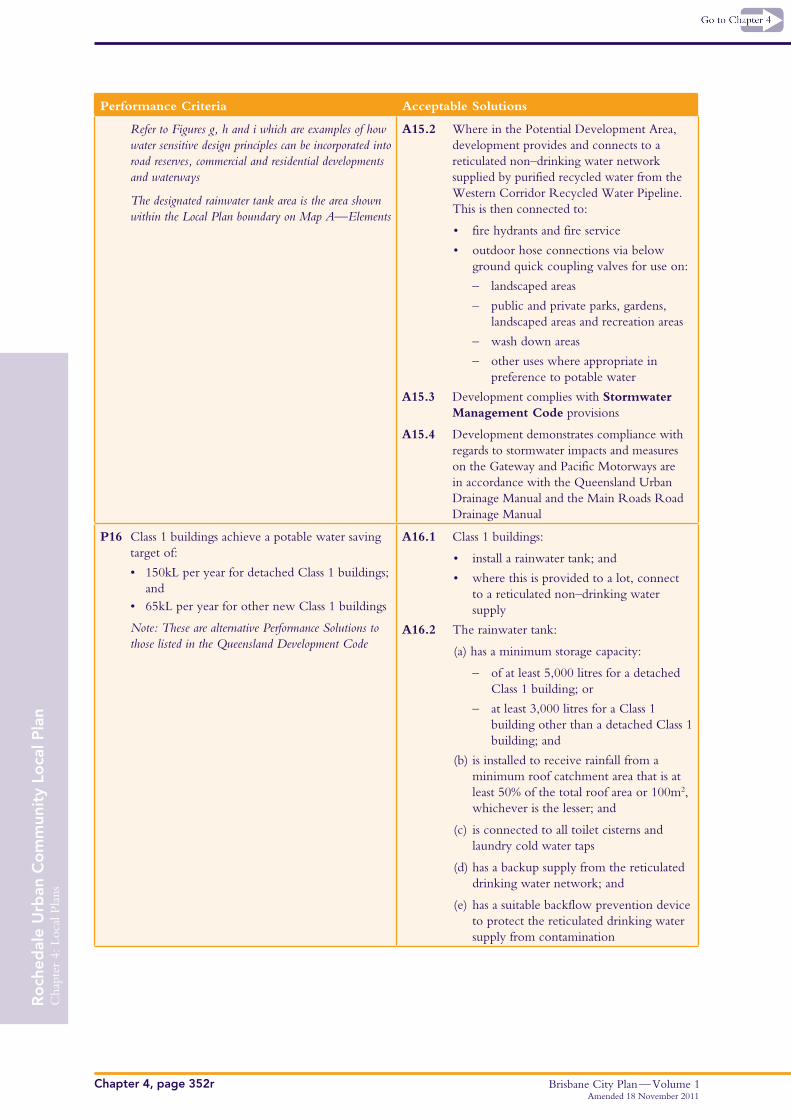
Refer to Figures g, h and i which are examples of how water sensitive design principles can be incorporated into road reserves, commercial and residential developments and waterways
The designated rainwater tank area is the area shown within the Local Plan boundary on Map A—Elements
A15.2 Where in the Potential Development Area, development provides and connects to a reticulated non–drinking water network supplied by purified recycled water from the Western Corridor Recycled Water Pipeline. This is then connected to:
• fire hydrants and fire service
• outdoor hose connections via below ground quick coupling valves for use on:
– landscaped areas
– public and private parks, gardens, landscaped areas and recreation areas
– wash down areas
– other uses where appropriate in preference to potable water
A15.3 Development complies with Stormwater Management Code provisions
A15.4 Development demonstrates compliance with regards to stormwater impacts and measures on the Gateway and Pacific Motorways are in accordance with the Queensland Urban Drainage Manual and the Main Roads Road Drainage Manual
P16 Class 1 buildings achieve a potable water saving target of:
• 150kLperyearfordetachedClass1buildings;and
• 65kLperyearforothernewClass1buildings
Note: These are alternative Performance Solutions to those listed in the Queensland Development Code
A16.1 Class 1 buildings:
• install a rainwater tank; and
• where this is provided to a lot, connect to a reticulated non–drinking water supply
A16.2 The rainwater tank:
(a) has a minimum storage capacity:
– of at least 5,000 litres for a detached Class 1 building; or
– at least 3,000 litres for a Class 1 building other than a detached Class 1 building; and
(b) is installed to receive rainfall from a minimum roof catchment area that is at least 50% of the total roof area or 100m2, whichever is the lesser; and
(c) is connected to all toilet cisterns and laundry cold water taps
(d) has a backup supply from the reticulated drinking water network; and
(e) has a suitable backflow prevention device to protect the reticulated drinking water supply from contamination
Where for reconfiguring a lot in the Very–low Density Residential element
P17 Development is to protect and strengthen the ecological values of the precinct while maintaining a semi–rural character
A17.1 Minimum lot size is 2,000m2
Note: smaller lot sizes may be supported for ecologically sensitive development that retains a semi–rural character and protects and strengthens the ecological values of the precinct
A17.2 Subdivision layouts are designed to protect and strengthen significant vegetation and koala habitat linkages through the establishment of Environmental Protection Zones
Where for Multi–unit dwellings
P18 Landscaping must facilitate sustainable subtropical design by providing:
• sufficientspacefortheretentionand/or establishment of significant substantial vegetation
• designandplantselectiontominimisewateruse and contribute to stormwater management
A18.1 A minimum 40% of the site area is provided as open space with a minimum dimension of 3m, with half of the open space dedicated deep planting with a minimum dimension of 6m
A18.2 Species are selected in accordance with Rochedale Urban Community Preferred Plant Species List within the Planting Species Planning Scheme Policy
Where for Dual Occupancies in the Low–density residential element
P19 Dual Occupancies have the visual appearance of a single detached House
A19.1 Minimum total site area is 800m2
A19.2 Minimum average lot width is 20m
A19.3 Maximum site cover is:
• 60% for sites having an area of less than 1,000m2
• 50% for site having an area of 1,000m2 or greater
A19.4 Where provided side by side, dwellings share a wall for at least 50% of the total building length
P20 Dual Occupancies are distributed to be subordinate to single, detached Houses within the landscape
A20.1 The maximum percentage of sites that are occupied by Dual Occupancies is 10%
A20.2 Dual Occupancies do not border another site occupied or subject to a current approval for a Dual Occupancy except where 2 corner sites share a boundary, provided that the number of Dual Occupancies fronting a single intersection does not exceed 2
Where for a Multi–unit dwelling in the Low–density Residential element
P21 Multi–unit dwellings are:
• co–locatedwithlanddesignatedforincreasedresidential densities; or
• locatedwithinacomfortablewalkingdistanceof a centre; or
• integratedwithalocalpark
A21.1 Multi–unit dwellings are located:
• adjoining land in the Low–medium density residential element; or
• within 400m of a Neighbourhood Centre lot boundary; or
• directly overlooking a district informal use or local informal use park
Where for development within the Mixed Use element
P22 Residential uses are the primary use within any development
A22.1 Residential uses comprise a minimum of 70% of the gross floor area of the overall development for all buildings on a site
P23 Development must limit conflict between residential and commercial activity
A23.1 Minimum Lot sizes are:
• 1,600m² for Mixed Use buildings
OR
• 800m² and a minimum frontage of 20m for Multi–unit dwellings
A23.2 Non–residential uses must be designed and constructed to attenuate and minimise noise impacts to on–site or adjoining residential uses
A23.3 Separate pedestrian entries are provided for the residential and non–residential components of the development
P24 Mixed use buildings contain commercial uses orientated to the street to encourage active street frontages. Buildings must be designed with an adaptable ground floor to allow maximum flexibility in accommodating different uses (including centre activities) in the future
A24.1 Commercial uses are located on the ground floor and lower floors and are located on or near the street
A24.2 A minimum floor to ceiling height of 4.2m is provided for ground floor uses
Where for development within the Mixed Use element around the Town Centre and near the intersection of Gardner Road and Miles Platting Road
P25 Development is in keeping with the higher density character of the Mixed Use Precinct. Buildings emphasise corners, vistas and create interest in the streetscape
Low income affordable housing is also encouraged through development bonuses
Note: refer to design principles contained in Figures a, b and c
A25.1 Development is a minimum height of 2 storeys and 8.5m
A25.2 Gross floor area and building height is no more than:
• 1.5 times the site area and 4 storeys and 15m
OR
• 1.8 times the site area and 6 storeys and 20m where:
– a building has two street frontages and is located in one corner of a legal lot forming the apex of a road intersection or street corner, or
– it incorporates Community Facilities; or
– at least 10% of the total number of proposed dwelling units are low income affordable housing
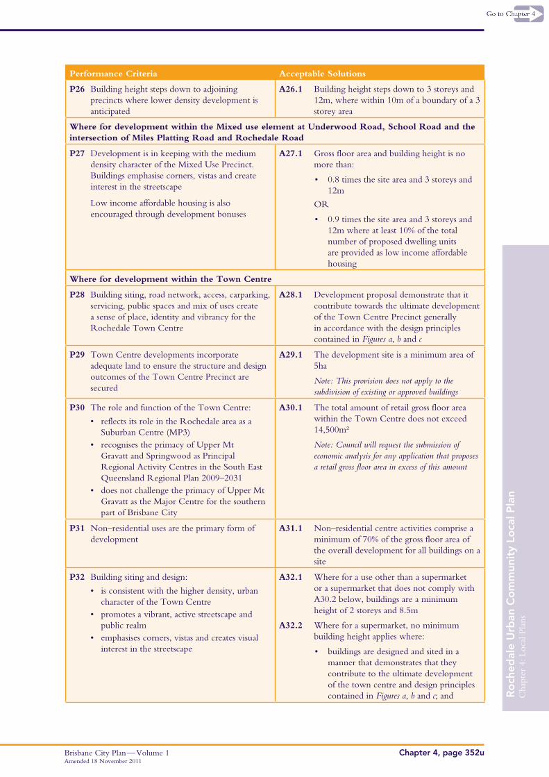
P26 Building height steps down to adjoining precincts where lower density development is anticipated
A26.1 Building height steps down to 3 storeys and 12m, where within 10m of a boundary of a 3 storey area
Where for development within the Mixed use element at Underwood Road, School Road and the intersection of Miles Platting Road and Rochedale Road
P27 Development is in keeping with the medium density character of the Mixed Use Precinct. Buildings emphasise corners, vistas and create interest in the streetscape
Low income affordable housing is also encouraged through development bonuses
A27.1 Gross floor area and building height is no more than:
• 0.8 times the site area and 3 storeys and 12m
OR
• 0.9 times the site area and 3 storeys and 12m where at least 10% of the total number of proposed dwelling units are provided as low income affordable housing
Where for development within the Town Centre
P28 Building siting, road network, access, carparking, servicing, public spaces and mix of uses create a sense of place, identity and vibrancy for the Rochedale Town Centre
A28.1 Development proposal demonstrate that it contribute towards the ultimate development of the Town Centre Precinct generally in accordance with the design principles contained in Figures a, b and c
P29 Town Centre developments incorporate adequate land to ensure the structure and design outcomes of the Town Centre Precinct are secured
A29.1 The development site is a minimum area of 5ha
Note: This provision does not apply to the subdivision of existing or approved buildings
P30 The role and function of the Town Centre:
• reflectsitsroleintheRochedaleareaasaSuburban Centre (MP3)
• recognisestheprimacyofUpperMtGravatt and Springwood as Principal Regional Activity Centres in the South East Queensland Regional Plan 2009–2031
• doesnotchallengetheprimacyofUpperMtGravatt as the Major Centre for the southern part of Brisbane City
A30.1 The total amount of retail gross floor area within the Town Centre does not exceed 14,500m²
Note: Council will request the submission of economic analysis for any application that proposes a retail gross floor area in excess of this amount
P31 Non–residential uses are the primary form of development
A31.1 Non–residential centre activities comprise a minimum of 70% of the gross floor area of the overall development for all buildings on a site
P32 Building siting and design:
• isconsistentwiththehigherdensity,urbancharacter of the Town Centre
• emphasisescorners,vistasandcreatesvisualinterest in the streetscape
A32.1 Where for a use other than a supermarket or a supermarket that does not comply with A30.2 below, buildings are a minimum height of 2 storeys and 8.5m
A32.2 Where for a supermarket, no minimum building height applies where:
• buildings are designed and sited in a manner that demonstrates that they contribute to the ultimate development of the town centre and design principles contained in Figures a, b and c; and
• any part of a supermarket building having a height of less than two storeys and 8.5m is wholly located behind other buildings so that no part other than a pedestrian entry is visible from a street, square or park
A32.3 Gross floor area and building height is no more than:
• 1.5 times the site area and 4 storeys and 15m
OR
• 1.8 times the site area and 6 storeys and 20m where:
– a building has two street frontages and is located in one corner of a legal lot forming the apex of a road intersection or street corner, or
– it incorporates Community Facilities; or
– at least 10% of the total number of proposed dwelling units are low income affordable housing
P33 The Town Centre contains clear and direct view lines and pedestrian connections to adjoining buildings, square and neighbourhoods
A33.1 Pedestrian links are provided between all road frontages, major activities and features of the Town Centre
A33.2 Direct line of sight is created between the Town Square, Main Street and surrounding residential neighbourhoods where possible
P34 Buildings must be designed with an adaptable ground floor to allow maximum flexibility in accommodating different (including non residential) uses in the future
A34.1 A minimum floor to ceiling height of 4.8m is provided for ground floors
P35 The Town Square and Main Street provides an urban environment that supports active uses on its fringes, meeting places, places of interest and comfortable and accessible pedestrian movement and activity
A35.1 Design of buildings, pathways, landscaping, public spaces and carparking integrates the centre and park and facilitates casual surveillance of the Town Square by:
• maximising pedestrian entrances of buildings and windows oriented towards the Town Square and Main Street
• ensuring pedestrian walkways are sheltered with awnings that protrude from buildings into these public open spaces
• ensuring at least 80% of ground floor frontage is occupied by ‘active’ uses (community facilities, retail sales, restaurants) and that outdoor dining facilities are located immediately adjacent to the Town Square
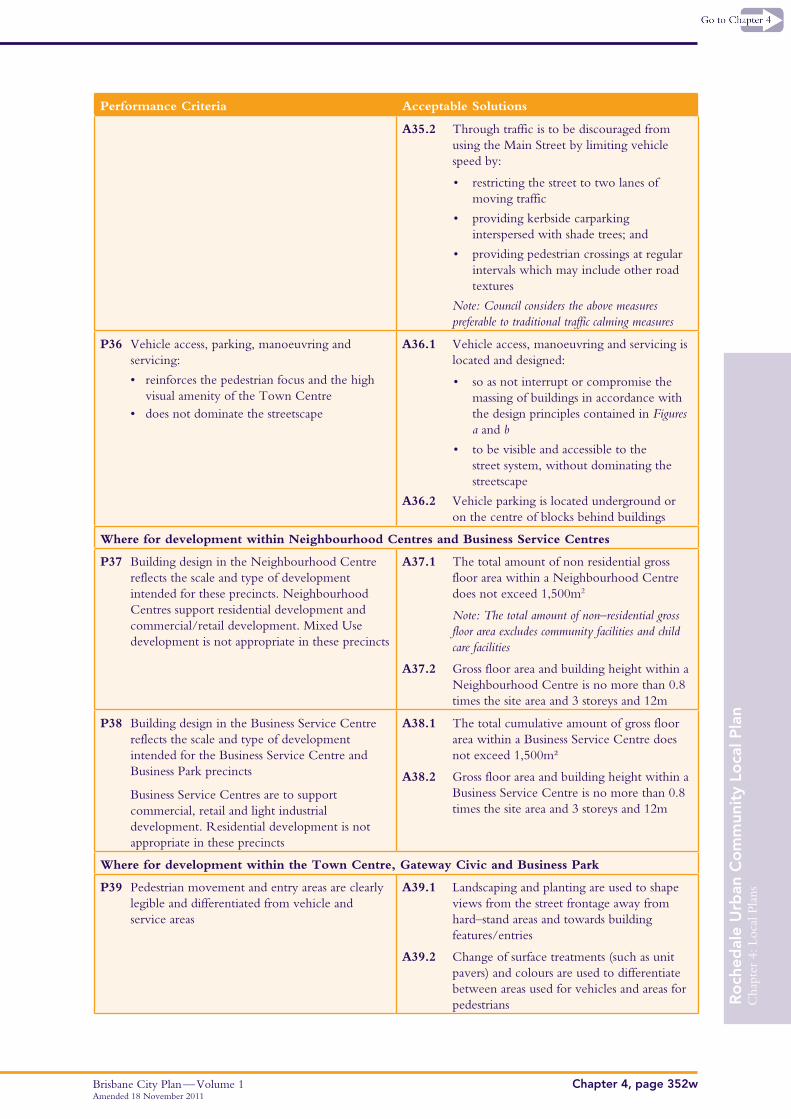
A35.2 Through traffic is to be discouraged from using the Main Street by limiting vehicle speed by:
• restricting the street to two lanes of moving traffic
• providing kerbside carparking interspersed with shade trees; and
• providing pedestrian crossings at regular intervals which may include other road textures
Note: Council considers the above measures preferable to traditional traffic calming measures
P36 Vehicle access, parking, manoeuvring and servicing:
• reinforcesthepedestrianfocusandthehighvisual amenity of the Town Centre
• doesnotdominatethestreetscape
A36.1 Vehicle access, manoeuvring and servicing is located and designed:
• so as not interrupt or compromise the massing of buildings in accordance with the design principles contained in Figures a and b
• to be visible and accessible to the street system, without dominating the streetscape
A36.2 Vehicle parking is located underground or on the centre of blocks behind buildings
Where for development within Neighbourhood Centres and Business Service Centres
P37 Building design in the Neighbourhood Centre reflects the scale and type of development intended for these precincts. Neighbourhood Centres support residential development and commercial/retail development. Mixed Use development is not appropriate in these precincts
A37.1 The total amount of non residential gross floor area within a Neighbourhood Centre does not exceed 1,500m2
Note: The total amount of non–residential gross floor area excludes community facilities and child care facilities
A37.2 Gross floor area and building height within a Neighbourhood Centre is no more than 0.8 times the site area and 3 storeys and 12m
P38 Building design in the Business Service Centre reflects the scale and type of development intended for the Business Service Centre and Business Park precincts
Business Service Centres are to support commercial, retail and light industrial development. Residential development is not appropriate in these precincts
A38.1 The total cumulative amount of gross floor area within a Business Service Centre does not exceed 1,500m²
A38.2 Gross floor area and building height within a Business Service Centre is no more than 0.8 times the site area and 3 storeys and 12m
Where for development within the Town Centre, Gateway Civic and Business Park
P39 Pedestrian movement and entry areas are clearly legible and differentiated from vehicle and service areas
A39.1 Landscaping and planting are used to shape views from the street frontage away from hard–stand areas and towards building features/entries
A39.2 Change of surface treatments (such as unit pavers) and colours are used to differentiate between areas used for vehicles and areas for pedestrians
P40 Buildings within the Gateway Civic, Town Centre and Business Park (North) areas achieve design excellence and innovation consistent with sub–tropical design principles
A40.1 No solution provided
Where for development within Gateway Civic
P41 Building siting, road network, access, carparking, servicing, public spaces and mix of uses create a sense of place, identity and vibrancy for the Gateway Civic Element
A41.1 The Gateway Civic element develops in accordance with the design principles contained in Figure a
P42 Building size and scale reflect the role of the Gateway Civic as an entry precinct to Rochedale
A42.1 Gross floor area and height is no more than:
• 1.2 times the site area and 4 storeys and 15m
OR
• 1.5 times the site area and 6 storeys and 20m where:
– a building has two street frontages and is located in one corner of a legal lot forming the apex of a road intersection or street corner
Note: Refer to Figure a
P43 Development must be designed to mitigate impacts on the values of adjoining habitat areas and ecological corridors
A43.1 Development incorporates sensitive design measures to mitigate adverse impacts on habitat areas and ecological corridors such as: buffer planting, appropriate setbacks and fencing
Where for development within the Business Park
P44 Building orientation integrates with the District Park
A44.1 Windows, outlook, location of staff amenities (eg decks or balconies) are located to directly overlook the District Park
• reducestheappearanceofscaleandbulkof the development through massing and articulation
A45.1 Building height is no more than 4 storeys and 15m
A45.2 The gross floor area for a convention centre is no more than 1,800m²
Where for development within the Future Industry Precinct
P46 Building design, landscaping and carparking reflect the site’s visible location adjacent to the Gateway Motorway and as an entry precinct to Rochedale
A46.1 A landscaped strip with a minimum width of 6 metres is provided along all road frontages
A46.2 Site cover does not exceed 75%
A46.3 Building height does not exceed 15m
A46.4 Car parking areas are to be consolidated into parking courts internal to the site
This Glossary defines terms used in this Local Plan. Where a definition conflicts with a definition in the City Plan, this definition prevails.
Boulevard road: A road that separates a public waterway corridor from land suitable for urban development. Boulevard roads are intended to provide a high level of visual and physical access to public waterway corridors.
Deep planting: An area where trees with the capacity to grow to more than 10m are planted to ensure the most favourable conditions for their development and ongoing viability. An area required for deep planting must:
• beprovidedwithnolessthan50%ofavailablesunlightbetween10amand2pm (Note: shadow diagrams must be submitted for mid–winter at 10am, 12 noon and 2pm).
Dual reticulation area: An area within which lots are serviced by reticulated potable and non–drinking water networks.
Dual occupancy: A use of premises as the principal place of longer term residence by two discrete households, domestic groups or individuals where the building form consists of two dwellings attached side by side and for over 50% of their length.
Educational purposes: Where in the Business Park element, means the use of premises for training and instruction designed to impart knowledge and develop skill in scientific, medical, media, telecommunications, bio–technology or similar high–tech industries. The term does not include a preschool, primary school or secondary school.
Integrated Water Management Plan: An Integrated Water Management Plan (IWMP) identifies the range of strategies and actions proposed to integrate water supply, wastewater and stormwater and thus ensure protection of affected waterways and catchment areas. An IWMP also identifies those Water Sensitive Urban Design measures proposed to be incorporated in a development to ensure protection of the water cycle. An IWMP must provide sufficient information on how these matters are to be dealt with for the particular site. Detailed design of the drainage network and Water Sensitive Urban Design measures will usually be required as a subsequent application for operational works or as a condition of approval. The IWMP includes details of when the proposed measures are to be adopted and how implementation is to be ensured such as covenants on each lot conditioned through development
Low income affordable housing: is accommodation:
• thatisspecificallydesignedtocatertotheneedsoflowincomehouseholds(whichmayincludespecialneedsand aged care households)
• whichisaccessibletohouseholdsinthelowest40%ofincomeunitswherebyrentdoesnotexceed30%ofgross household income after any applicable Commonwealth Rent Assistance is deducted
• wheresitemanagementisprovidedbyaregisteredhousingproviderthatincludesthemonitoringoftenant’seligibility to qualify for low income affordable housing
Applicants providing low income affordable housing will be required to enter into an agreement with Council to maintain the low income affordable housing for 10 years by signing a covenant or similar binding agreement outlining the terms of the on–going operation of the low income affordable housing.
Site cover: The proportion of the site (expressed as a percentage) covered by buildings or structures measured to the outermost projections and car and service vehicle parking loading and servicing areas.
This schedule identifies valuable local features that positively contribute to the character of Rochedale. These features are to be protected and optimised through incorporation within the Rochedale public park system.
Schedule
Location Valuable Natural Feature
South–west of Gardner Road and Ford Road extension intersection (rear portion of 297 and 301 Gardner Rd)
Native vegetation providing a physical and ecological connection to the waterway corridor
North–east of Gardner Road and new mid–block road intersection (front portion of 310 and 340 Gardner Rd)
Scattered mature vegetation and open space
South–west of Prebble Street and Gardner Road intersection (common boundary of 231 and 237 Gardner Rd, and 26 Prebble St)
Ridge top location with expansive local views. Key component of east–west fauna corridor from Leslie Harrison Dam catchment and Bulimba Creek
South–east of Gardner Road and Ford Road extension intersection (corner of 284, 286 and 290, Gardner Rd)
Mature vegetation adjacent to flat expansive open space
North/North–east of Rochedale Road and Ford Road extension intersection (middle portion of 300 and 326 Rochedale Rd)
Scattered mature vegetation with views to the Leslie Harrison Dam catchment to the east
North–east of Rochedale Road and Ford Road intersection (common boundary of 380 and 434 Rochedale Rd, and 20 Ford Rd)
Scattered mature vegetation, double row of orchard trees and flat open space
South–east of Rochedale Road and Ford Road intersection (520 Rochedale Rd)
Mature row of Cadagi (Eucalyptus torelliana) windbreak and adjacent flat open space
South–west of the Gardner Road and Miles Platting Road intersection (447 Miles Platting Rd)
Significant collection of cultivated rare and endangered plants
North–east of the Miles Platting Road and Gardner Road intersection (480 and 490 Miles Platting Rd)
Two outstanding examples of Weeping Figs (Ficus benjamina) and scattered established vegetation
South–east of the Miles Platting Road and Gardner Road intersection (central portion of 519 Miles Platting Rd)
Productive mango orchard adjacent to mature figs suitable for integration in a community garden
585 Miles Platting Rd (front portion) Two outstanding examples of Hill’s Figs (Ficus hillii)
North–west of the Rochedale Road and Miles Platting Road intersection (602 and 604 Miles Platting Rd, and 645 Rochedale Rd)
Cluster of native vegetation with central clearing and open space to the east
Immediately west of Redeemer Lutheran College (617 Miles Platting Rd and 416 Priestdale Rd)
Key pedestrian link between the waterway corridor and Redeemer Lutheran College. Also functions as a wildlife corridor between the waterway corridor and Leslie Harrison Dam catchment
North of Rochedale State High School (244 Priestdale Rd and 34 School Rd)
Scattered mature vegetation contributing to a north–south ecological link
South of Glenmore Crescent extension (South–eastern corner of 309 Priestdale Rd)
Native vegetation providing a physical and ecological connection to the waterway corridor