27

ROCK RIVER BASIN: HISTORICAL BACKGROUND, IEPA TARGETED WATERSHEDS, AND RESOURCE-RICH AREAS
by
Robert A. Sinclair Office of Surface Water Resources: Systems, Information & GIS
Illinois State Water Survey Hydrology Division Champaign, Illinois
A Division of the Illinois Department of Natural Resources
April 1996
CONTENTS Page
Introduction 1 Acknowledgments 1
Historical Perspective of the Basin 3Basin Physiography and Geology 3 Land Use 5 Basin Soils 5 Streams in the Basin 5
Streamflow and Sediment Quality 8 Streamflow 8 Sediment Quality 8
Surface Water Quality 13 IEPA Stream Assessment Criteria 13 IEPA Surface Water Quality Assessment 14
Ground-Water Resources and Quality 16 Ground-Water Resources 16Ground-Water Quality 17
IEPA Targeted Watershed Approach 19 Major Watershed Areas 19 Criteria for Selecting Targeted Watersheds 19 TWA Program Activities 19 TWA for the Rock River Basin 20
References 23
INTRODUCTION
Conservation 2000, a program to improve natural ecosystems, visualizes resource-rich areas, and promotes ecosystem projects and development of procedures to integrate economic and recreational development with natural resource stewardship. The Rock River basin is one of the areas identified for such projects. This report briefly characterizes the water resources of the basin and provides other relevant information.
The Rock River originates in the Horicon Marsh in Dodge County, Wisconsin, and flows in a generally southerly direction until it enters Illinois just south of Beloit. Then it flows in a southwesterly direction until it joins the Mississippi River at Rock Island. The river flows for about 163 miles in Illinois, and its total length from head to mouth is about 318 miles.
The Illinois portion of the Rock River basin covers Boone, Winnebago, and Ogle Counties; major portions of McHenry, Stephenson, DeKalb, Lee, Henry, and Whiteside Counties; and minor portions of Jo Daviess, Kane, Carroll, Bureau, Mercer, and Rock Island Counties. The total area of the Rock River is 10,915 square miles, about 5,650 of which are in Illinois (Figure 1).
The Rock River has three major tributaries: the Pecatonica, Kishwaukee, and Green Rivers, with drainage areas of 2,641, 1,257, and 1,131 square miles and river lengths of 92.8 (in Illinois), 64.2, and 91.2 miles, respectively (Healy, 1979). Smaller tributaries include Elkhorn Creek (247 square miles), Rock Creek (237 square miles), Kyte River (194 square miles), and Leaf River (117 square miles). The majority of the basin is in agricultural lands, primarily row crops. Major urban areas are Rockford (population 139,426), Moline-Rock Island (83,754), DeKalb (34,925), Sterling-Rock Falls (24,786), Freeport (25,840), Belvidere (15,958), and Dixon (15,144). Population figures are from the 1991 U.S. Census Population and Housing publication.
Acknowledgments
Various State Water Survey personnel helped in preparation of this report. Brett Ward prepared the color maps. John Blomberg supplied the water use information. H. Allen Wehrmann prepared the ground-water information section, and Misganaw Demissie prepared the benchmark sediment monitoring section. Krishan P. Singh reviewed the draft report and made many helpful comments. Sarah Hibbeler edited the manuscript, and Norma Lee Rhines typed the final report.
1
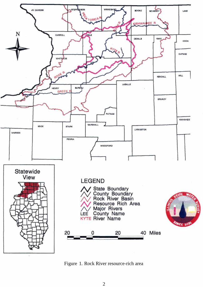
Figure 1. Rock River resource-rich area
2
HISTORICAL PERSPECTIVE OF THE BASIN
Development in the basin began in the early 1900s when two large swamps in the Green River basin were drained and the river was dredged and straightened. By the 1930s, seven low-head dams, 9 to 15 feet high, were constructed in the Rock River and they served as sources of hydroelectric power. In 1938, only one dam was still being used for that purpose; the pools formed by the other dams are now being used mostly for recreation.
The Rock River basin, as defined by the Illinois State Planning Commission or ISPC (1938), occupies the northwest portion of Illinois. It includes watersheds of the Rock, Green, Kishwaukee, and Pecatonica Rivers, and areas drained by the Galena, Apple, and Plum Rivers and other small tributaries entering directly into the Mississippi River, from the Wisconsin/Illinois border to the confluence of the Rock River with the Mississippi. The basin covers 6,481 square miles, or 4,147,840 acres, in Illinois as given in Table 1. This chapter is largely based on the ISPC (1938) report.
Basin Physiography and Geology
The northwest portion of the basin, including all of Jo Daviess County, is very hilly. With the exception of Jo Daviess County and the northwest corner of Carroll County, the entire basin is covered with deposits of glacial drift (Illinoisian drift) overlying Mississippi loess from a depth of about 5 feet in the hilly country to more than 50 feet in the valleys. Below these deposits in the valleys lie blue clay and sand and gravel beds to a depth of about 70 feet, identified as Pleistocene drift. Immediately underlying these deposits and paralleling the Mississippi River is a rock outcrop of Quaternary age, about 3 to 6 miles wide. The formation follows the Rock River upstream for about 20 miles from its confluence with the Mississippi and extends 3 to 6 miles on either side of the river. Immediately east of this rock formation, Silurian rock underlies all of Whiteside County, forming a narrow strip about 3 miles wide, which parallels the Quaternary along the west side of Carroll County and curves east to underlie the southeast corner of Jo Daviess County and the southwest corner of Stephenson County, paralleling the northern boundary of Carroll County. In the remainder of the basin, Ordovician rock of Galena and Plattville type underlies the drift.
The eastern portion of the basin is a high tableland, covering Boone, McHenry, Kane, and DeKalb Counties. A rolling ridge of high land along the southern boundary separates the valley of the Green River from the area further south. Elevations vary from 540 feet in Rock Island County to 1,220 feet above mean sea level in Jo Daviess County.
Coal deposits are found in the southeast portion of the basin. Lead and zinc are mined in the northwest. Limestone, sand, and gravel are well distributed throughout the basin.
The bottomlands of the Rock River, the Pecatonica River, Richland Creek (a tributary to the Pecatonica), and the Kishwaukee River, and the Mississippi River bottomlands in Jo Daviess, Carroll, and Whiteside Counties, are subject to periodic flooding. These bottomlands cover approximately 130,000 acres.
3
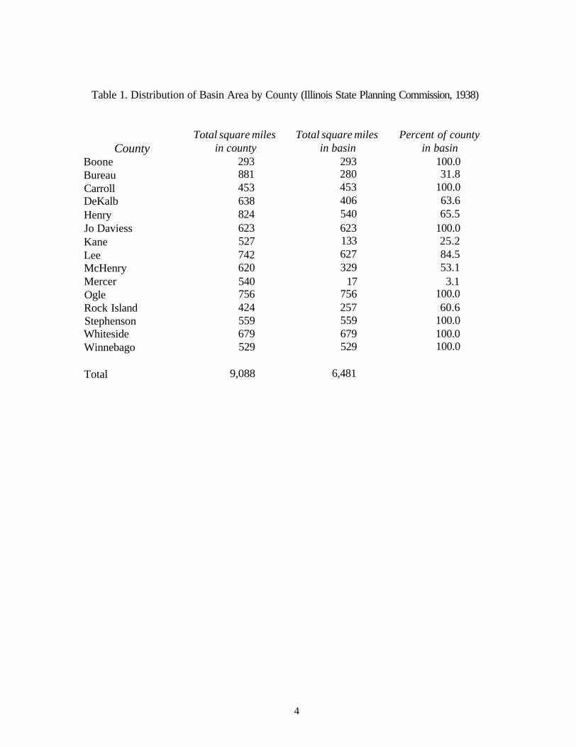
Table 1. Distribution of Basin Area by County (Illinois State Planning Commission, 1938)
Total square miles Total square miles Percent of county County in county in basin in basin
Boone 293 293 100.0 Bureau 881 280 31.8 Carroll 453 453 100.0 DeKalb 638 406 63.6 Henry 824 540 65.5 Jo Daviess 623 623 100.0 Kane 527 133 25.2 Lee 742 627 84.5 McHenry 620 329 53.1 Mercer 540 17 3.1 Ogle 756 756 100.0 Rock Island 424 257 60.6 Stephenson 559 559 100.0 Whiteside 679 679 100.0 Winnebago 529 529 100.0
Total 9,088 6,481
4
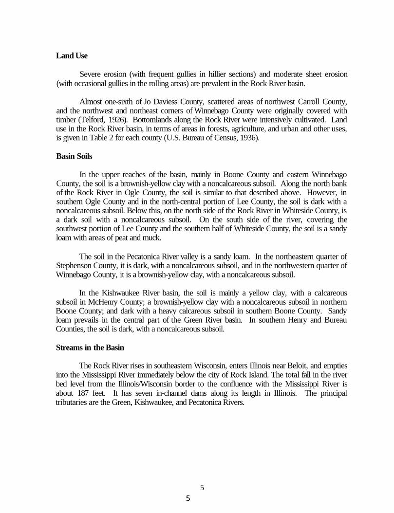
Land Use
Severe erosion (with frequent gullies in hillier sections) and moderate sheet erosion (with occasional gullies in the rolling areas) are prevalent in the Rock River basin.
Almost one-sixth of Jo Daviess County, scattered areas of northwest Carroll County, and the northwest and northeast corners of Winnebago County were originally covered with timber (Telford, 1926). Bottomlands along the Rock River were intensively cultivated. Land use in the Rock River basin, in terms of areas in forests, agriculture, and urban and other uses, is given in Table 2 for each county (U.S. Bureau of Census, 1936).
Basin Soils
In the upper reaches of the basin, mainly in Boone County and eastern Winnebago County, the soil is a brownish-yellow clay with a noncalcareous subsoil. Along the north bank of the Rock River in Ogle County, the soil is similar to that described above. However, in southern Ogle County and in the north-central portion of Lee County, the soil is dark with a noncalcareous subsoil. Below this, on the north side of the Rock River in Whiteside County, is a dark soil with a noncalcareous subsoil. On the south side of the river, covering the southwest portion of Lee County and the southern half of Whiteside County, the soil is a sandy loam with areas of peat and muck.
The soil in the Pecatonica River valley is a sandy loam. In the northeastern quarter of Stephenson County, it is dark, with a noncalcareous subsoil, and in the northwestern quarter of Winnebago County, it is a brownish-yellow clay, with a noncalcareous subsoil.
In the Kishwaukee River basin, the soil is mainly a yellow clay, with a calcareous subsoil in McHenry County; a brownish-yellow clay with a noncalcareous subsoil in northern Boone County; and dark with a heavy calcareous subsoil in southern Boone County. Sandy loam prevails in the central part of the Green River basin. In southern Henry and Bureau Counties, the soil is dark, with a noncalcareous subsoil.
Streams in the Basin
The Rock River rises in southeastern Wisconsin, enters Illinois near Beloit, and empties into the Mississippi River immediately below the city of Rock Island. The total fall in the river bed level from the Illinois/Wisconsin border to the confluence with the Mississippi River is about 187 feet. It has seven in-channel dams along its length in Illinois. The principal tributaries are the Green, Kishwaukee, and Pecatonica Rivers.
5
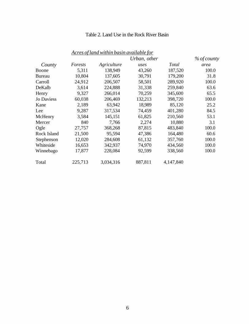
Table 2. Land Use in the Rock River Basin
Acres of land within basin available for Urban, other % of county
County Forests Agriculture uses Total area Boone 5,311 138,949 43,260 187,520 100.0 Bureau 10,804 137,605 30,791 179,200 31.8 Carroll 24,912 206,507 58,501 289,920 100.0 DeKalb 3,614 224,888 31,338 259,840 63.6 Henry 9,327 266,014 70,259 345,600 65.5 Jo Daviess 60,038 206,469 132,213 398,720 100.0 Kane 2,189 63,942 18,989 85,120 25.2 Lee 9,287 317,534 74,459 401,280 84.5 McHenry 3,584 145,151 61,825 210,560 53.1 Mercer 840 7,766 2,274 10,880 3.1 Ogle 27,757 368,268 87,815 483,840 100.0 Rock Island 21,500 95,594 47,386 164,480 60.6 Stephenson 12,020 284,608 61,132 357,760 100.0 Whiteside 16,653 342,937 74,970 434,560 100.0 Winnebago 17,877 228,084 92,599 338,560 100.0
Total 225,713 3,034,316 887,811 4,147,840
6
The Pecatonica River rises in Wisconsin, flows south into Stephenson County, adopts a bit of a southeasterly direction to Freeport, then gradually changes to a northeasterly direction through Winnebago County and discharges into the Rock River near Rockton in the northeast comer of the county. Its total drainage area is 2,641 square miles (Healy, 1979), about 860 of which are in Illinois. The river length in Illinois is about 92 miles. The river channel is very crooked and frequently doubles back on itself. The floodplain averages 1 mile or more in width.
The Kishwaukee River rises in the tablelands of McHenry County. It flows in a westerly direction across central McHenry and Boone Counties, and empties into the Rock River in southeastern Winnebago County. Its major tributary is the South Branch Kishwaukee River, which drains a major part of DeKalb County and about one-fourth of Kane County.
The Green River rises in Lee County and flows in a southwesterly direction through Lee, Bureau, and Henry Counties. It joins the Rock River in the west-central portion of Henry County. The river flows through gently rolling country for its entire length, about 91 miles, and drains an area of 1,131 square miles.
7
STREAMFLOW AND SEDIMENT QUALITY
Streamflow
There are ten continuous streamgaging stations in the Rock River basin. Table 3 contains information on the streams such as USGS gaging station numbers, drainage area, mean and peak flows (and their dates of occurrence) observed for water years 1993 and 1994, number of years in the period of record, and associated long-term mean flow. The long-term mean flow values versus drainage areas at the ten gaging stations are plotted in Figure 2. The slope of the line fitted is about 45°.
Table 3 shows that mean flows for water year 1993 (October 1992 to September 1993) were on average about 2.25 times the long-term mean flows. However, in water year 1994, mean flows were on average only eight percent higher than the long-term mean flows. Mean flows can change significantly from one year to another.
Though 1994 seems like a normal or average year, the observed peak flows are: 1) significantly higher than those observed in 1993 for the Kishwaukee River at Belvidere and near Perryville; 2) about the same order of magnitude for the South Branch Kishwaukee River, Rock River at Como, Elkhorn Creek, and Rock River near Joslin; and 3) significantly lower for the Pecatonica River, Rock River at Rockton, Green River, and Mill Creek. Mean flows in 1994 are only about 45 percent of those in 1993 on the average, and the flood peaks occurred during February 20-22, 1994, at all ten stations. (A rainstorm over frozen ground and snow cover yields much higher runoff than a similar storm in spring and summer.) Peak flows occurred on different days and months in 1993.
Sediment Quality
The Illinois State Planning Commission's Rock River basin report of July 1938 stated that the Rock River was heavily laden with silt in suspension, most of which washed down from the Pecatonica watershed as the result of erosion within that area. An unpublished Illinois Natural History Survey report of the same period stated that drainage ditches carrying silt in suspension also contributed to this type of pollution.
Neutron activation analysis has been used to analyze sediment cores from the Rock River and from two branches and the North Fork of Kent Creek, to determine the concentrations of thirteen heavy metals—titanium (Ti), copper (Cu), vanadium (V), manganese (Mn), arsenic (As), antimony (Sb), selenium (Se), chromium (Cr), nickel (Ni), scandium (Sc), iron (Fe), zinc (Zn), and cobalt (Co)—and two rare earths, samarium (Sm) and lanthanum (La) (Landsberger et al., 1990). The downstream sites of both the Rock River and the two branches of Kent Creek show elevated concentrations of several heavy metals including arsenic, antimony, and zinc. In addition, hundreds of parts per million of copper have been found in samples from the downstream site of the North Fork of Kent Creek. Toxicity tests of the sediments also indicate that the downstream sites are detrimental to life-forms. Analyses of
8
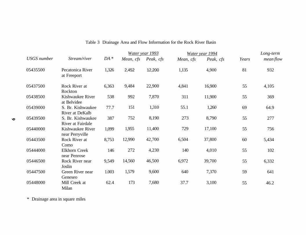
Table 3 Drainage Area and Flow Information for the Rock River Basin
USGS number Stream/river DA *
05435500 Pecatonica River 1,326 at Freeport
05437500 Rock River at 6,363 Rockton
05438500 Kishwaukee River 538 at Belvidee
05439000 S. Br. Kishwaukee 77.7 River at DeKalb
05439500 S. Br. Kishwaukee 387 River at Fairdale
05440000 Kishwaukee River 1,099 near Perryville
05443500 Rock River at 8,753 Como
05444000 Elkhorn Creek 146 near Penrose
05446500 Rock River near 9,549 Joslin
05447500 Green River near 1.003 Geneseo
05448000 Mill Creek at 62.4 Milan
Water year 1993 Mean, cfs Peak, cfs
2,452 12,200
9,484 22,900
992 7,870
151 1,310
752 8,190
1,955 11,400
12,990 42,700
272 4,230
14,560 46,500
1,579 9,600
173 7,680
Water year 1994 Mean, cfs Peak, cfs
1,135 4,900
4,841 16,900
311 11,900
55.1 1,260
273 8,790
729 17,100
6,504 37,800
140 4,010
6,972 39,700
640 7,370
37.7 3,100
Long-term Years mean flow
81 932
55 4,105
55 369
69 64.9
55 277
55 756
60 5,434
55 102
55 6,332
59 641
55 46.2
* Drainage area in square miles

Figure 2. Long-term mean flow versus drainage area
10
the data from the two branches of Kent Creek clearly indicate that heavy metal concentrations increase as the distance from the center of industrial activity (Rockford) decreases.
Suspended sediment concentration data have been collected since 1981 at two monitoring sites within the Rock River basin as part of the Illinois State Water Survey's Benchmark Sediment Monitoring Program for Illinois streams (Allgire and Demissie, 1995). The two stations are located on the Pecatonica River at Freeport and on the Rock River at Rockton. The data for the two stations (Figure 3) indicate that suspended sediment concentrations at the Pecatonica River site are higher than those at the Rock River site, implying that erosion and sediment delivery in the Pecatonica River watershed are higher than in the remaining part of the Rock River watershed upstream of Rockton. There is also an indication that suspended sediment concentrations have been decreasing at both stations during the monitoring period. The causes for such a decreasing trend are not known, but it may be associated with trends in precipitation or land use practices.
The Pecatonica River site monitors sediment delivery from the 1,326 square mile watershed upstream of the station. The Rock River sites monitor sediment delivery from a larger area, 6,363 square miles, that includes the Pecatonica River watershed.
11
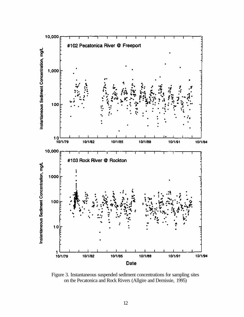
Figure 3. Instantaneous suspended sediment concentrations for sampling sites on the Pecatonica and Rock Rivers (Allgire and Demissie, 1995)
12
SURFACE WATER QUALITY
The Wisconsin Department of Natural Resources -Environmental Protection Division reported that many streams in the lower Rock River basin in Wisconsin received pollution-related wastes (State of Wisconsin, 1971). These wastes were primarily organic and consisted of treated sewage and industrial wastes. Toxic substances were being discharged to some lakes from several industries in the basin. The report recommended that the removal of nutrients or the diversion of sewage treatment plant effluents around recreational lakes be given serious consideration.
Recently, the Illinois State Water Survey reported a decreasing trend in nitrate-nitrogen levels in the Rock River basin in Illinois (IDENR, 1994). This may be attributed to improved farming practices and reduced use of septic tanks by lakefront communities.
The information given below is summarized from the Illinois Environmental Protection Agency, IEPA, Illinois Water Quality Report, 1992-1993, published in 1994.
IEPA Stream Assessment Criteria
The IEPA describes water quality conditions in terms of the degree to which waters attain designated use standards. For example (IEPA, 1994):
• Full Support: the water quality meets the needs of all designated uses protected by applicable water quality standards.
• Full/Threatened: water quality is presently adequate to maintain designated uses, but if a declining trend continues, only partial support may be attained in the future.
• Partial Support/Minor Impairment: water quality has been impaired, but only to a minor degree. There may be minor exceedences in applicable water quality standards or criteria for assessing the designated use attainment.
• Partial Support/Moderate Impairment: water quality conditions are impaired to a greater degree, inhibiting the waterbody from meeting all the needs for that designated use.
• Nonsupport: water quality is severely impaired and not capable of supporting the designated use to any degree.
Water quality conditions are considered for specific or individual uses, including aquatic life, swimming, drinking water, recreation, secondary contact, and fish consumption. In addition, an aggregate assessment of the overall use support is provided.
Illinois' waters are classified for a variety of designated uses: 1) General use - provides protection for indigenous aquatic life, primary and secondary contact recreation, and agricultural and industrial uses; 2) Public and food processing water supplies - provides protection for potable water supplies and water use for food processing purposes; 3) Lake Michigan - provides protection for Illinois' portion of Lake Michigan waters through stringent water quality standards; and 4) Secondary contact and indigenous life use - this is the least
13
stringent designated use and applies to certain streams and canals in the Chicago area. Water quality standards for use 2 are somewhat stricter than those for use 1.
IEPA Surface Water Quality Assessment
A total of 1,443.4 stream miles in the Rock River basin were assessed for overall use support (IEPA, 1994). Evaluated and monitored stream miles (604.3 and 893.1, respectively) combine for a total of 1,443.4 miles. Overall aquatic life use was rated as full support on 881.1 stream miles (61.5 percent); full support but threatened use on 45.6 stream miles (3.2 percent); partial support with minor impairment on 449.0 stream miles (31.1 percent); and partial support with moderate impairment on 60.7 stream miles (4.2 percent).
Fish consumption was assessed on 327.6 stream miles in the Rock River basin. All these miles were rated as full use support. Of these, 302.6 miles were assessed for swimming: 165.9 miles as full support, 29.0 miles as partial support and moderate impairment, and 107.7 miles as nonsupport. Swimming use does not apply to stream miles with disinfection exemptions. Surface water is not used as a source of drinking water in the Rock River basin.
Causes and sources of less than full support for rivers, creeks, and tributaries in the Rock River basin are summarized below:
Rock River. Phosphorus from municipal wastewater discharges and agricultural runoff is the main reason 63 percent of mainstream miles were rated partial support/minor impairment. The rest of the main stream fully supports aquatic life uses.
Pecatonica River. As in the Rock River, phosphorus is the main reason 82 percent of mainstream miles were rated as partial support/minor impairment (the remaining 18 percent were rated as full support). Out of 21 tributaries to the Pecatonica River, 13 attained full aquatic life use along their entire length, 6 were rated as having partial support/minor impairment, and Yellow Creek and Richland Creek were rated as having full use support for 39 and 89 percent, respectively, of their total stream miles.
Kishwaukee River. About 85.4 percent of stream miles in the Kishwaukee River subbasin fully support aquatic life use. About 50 percent of stream miles with partial support/minor impairment were found in Mokeler Creek, East Branch Killbuck Creek, Lawrence Creek, and South Branch Kishwaukee River. Reduction in use support is caused by municipal wastewater discharges, cropland runoff, and organic enrichment.
Green River. Of the total 272.8 miles assessed, 43 percent were rated full support, 37 percent were rated partial support/minor impairment, and the remaining 20 percent were rated partial support/moderate impairment. Impairment is primarily attributed to nutrients and habitat alterations due to channelization and agricultural runoff.
14
Kyte River. Eighty-seven percent of the Kyte River and all three of its tributaries (Steward Beach, Prairie, and South Beach Creeks) were rated as fully supporting aquatic life use.
Elkhorn and Rock Creeks. Sixty-eight percent of the assessed reaches of these creeks were rated as fully supporting aquatic life use.
Miscellaneous Tributaries. Fifteen other tributaries to the Rock River were assessed for aquatic life use support. Eleven provided full support and four had partial support/minor impairment.
15
GROUND-WATER RESOURCES AND QUALITY Ground water is a plentiful resource throughout the Rock River basin. Large quantities
are withdrawn from sand and gravel aquifers in the glacial drift, and from shallow dolomite and sandstone bedrock aquifers (Visocky et al., 1985). The bedrock aquifers are Silurian, Ordovician, and Cambrian in age. The sand and gravel and shallow dolomite aquifers are generally encountered at depths less than 500 feet; the depth to sandstone aquifers varies considerably, but generally exceeds 500 feet. Pumpage from glacial sand and gravel wells is concentrated along river systems in communities such as Freeport-, Rock Falls, and Rockford. Pumpage from shallow dolomite wells in the basin is largely for domestic supplies. Pumpage from sandstone wells is concentrated in the Belvidere, Rockford, Freeport, Sterling, Dixon, Rochelle, and Quad Cities areas (Sasman and Baker, 1966).
Ground-Water Resources
The Illinois State Water Survey, Illinois State Geological Survey, and the U.S. Geological Survey have been investigating the geology and ground-water resources of the Rock River valley for decades (USGS, 1986a, 1986b). Several definitive studies of geology and ground-water resources were completed by the State Surveys in the 1950s and early 1960s (Hanson, 1955; Foster, 1956; Hackett and Bergstrom, 1956; and Hackett, 1960). They found that significant sand and gravel deposits are associated with glacial outwash along the Rock Bedrock valley in Winnebago County and the Green River Lowlands in Lee and Whiteside Counties and that well yields in excess of 1,000 gallons per minute are possible in these deposits. Several additional studies of sand and gravel resources along the Rock River and within basin counties were completed in the late 1960s (Anderson, 1967; Hunter and Kempton, 1967) along with more general descriptions of geologic materials in northern and northwestern Illinois (Bradbury, 1965; Frye et al., 1969).
The Rock River serves as the discharge zone for regional ground water throughout the basin, including discharge from sand and gravel deposits as well as underlying bedrock formations. Walton (1965) estimated ground-water discharge to the Rock River at Rockton, Oregon, and Como as 0.39, 0.36, and 0.39 cubic feet per second per square mile, respectively, for years of near normal precipitation. Avery (1994) estimated ground-water discharge from beneath the Byron Superfund site in Ogle County to the Rock River to be as high as 30,900 cubic feet per day.
In the mid-1930s, about half of the 150 communities in the region received their supply of drinking water from wells and from the Mississippi River (ISPC, 1938). Nearly two-thirds of the ground-water supplies were derived from bedrock sources while the remaining one-third was derived from unconsolidated drift deposits. Ground-water withdrawals in northwestern Illinois (including a few counties outside of the Rock River basin) in 1963 were estimated by Sasman and Baker (1966) to be 78.9 million gallons per day (mgd). Of the total 1963 pumpage, 65 percent was pumped from sandstone wells, 8 percent from shallow dolomite wells, and 27 percent from glacial drift wells. Public water supplies accounted for 69 percent of the 1963 withdrawals, industrial supplies for 20 percent, and domestic use for 11 percent.
16

By 1993, public ground-water withdrawals within the four basin counties of Winnebago, Ogle, Lee, and Whiteside were estimated to be 45 mgd.
Annual pumpage rates and the number of wells in each aquifer are summarized in Table 4 for Winnebago, Ogle, Lee, and Whiteside Counties.
Table 4. Total Annual Ground-Water Pumpage
Aquifer
Sand and gravel Shallow bedrock Deep bedrock
Total
Annual pumpage, 1993 (million gallons per day)
11.7 1.1
32.0 44.8
Number of wells
57 112 107 276
Ground-Water Quality
Ground water throughout the Rock River basin is of generally good quality for most needs. The water is considered hard in all three aquifer systems, approximately 400 milligrams per liter (mg/L). Iron concentrations are extremely variable in the sand and gravel aquifers and quite often exceed the recommended standard of 1.0 mg/L. Iron concentrations tend to decrease with depth and are generally below 1.0 mg/L in the shallow bedrock and below 0.3 mg/L in the deep bedrock aquifers. Nitrate, like iron, is quite variable throughout the shallow sand and gravel aquifers but is generally around 3 mg/L or less, well below the drinking water standard of 10 mg/L nitrate-nitrogen. Some localized areas of elevated nitrate concentrations are known, particularly in the upper reaches of the basin in Winnebago County. This is largely due to the use of septic systems and fertilizers in areas unable to assimilate the nitrate load (Wehrmann, 1983). Like iron, nitrate concentrations tend to decrease with depth. Chloride and sulfate concentrations also are well within acceptable limits, with median concentrations below 25 and 50 mg/L, respectively, for all aquifer systems.
While ground water remains an excellent water source within the basin, recent investigations have revealed a number of contamination problems, particularly within the shallow aquifers in the upper Rock River basin in Ogle and Winnebago Counties. A rating scheme based upon the "threat to human health via groundwater" was devised to identify potential trouble areas (Gibb et al., 1984). Application of the rating scheme within Winnebago and Ogle Counties resulted in the delineation of "hot spots" within the Rockford metropolitan area and secondary risk areas at Pecatonica, Rockton, South Beloit, and Rochelle. Wehrmann (1983) examined nitrate contamination problems in the sand and gravel terrace deposits along the upper Rock River at Roscoe and subsequent contamination of that same aquifer by volatile organic compounds (VOCs), principally trichloroethylene.
17

A regional examination of ground-water quality around Rockford found much of the ground water used by residents and industry in the area to be satisfactory with regard to VOCs and selected trace metals (Wehrmann et al., 1988). However, one area in southeast Rockford was found to be significantly contaminated with VOCs. More than 100 domestic wells and at least two municipal wells were estimated to contain VOCs in excess of federal drinking water standards. The area is currently listed as a Superfund site. Other contamination studies have been conducted by the USGS at Belvidere (Boone County) and Byron (Ogle County).
18
IEPA TARGETED WATERSHED APPROACH
The IEPA is committing available resources within Bureau of Water programs to target watersheds with a maximum potential of realizing environmental benefits (IEPA, 1993). These programs and watersheds have great impact on issues such as human health and ecosystem protection. The Targeted Watershed Approach, TWA, is meant to facilitate water quality management planning. The objectives of the approach are: 1) identification of watersheds with the most critical water quality problems and development of solutions; 2) characterization of watersheds with the greatest potential for improvement using the State's Biological Stream Characterization process; 3) protection of existing high quality water resources considered to be threatened; and 4) integration of point and nonpoint source program activities.
Major Watershed Areas
The seven major watershed areas (MWAs) covering the state are: MWA #1 - Rock River basin MWA #2 - DesPlaines, Fox, Kankakee, and Illinois Rivers upstream of the Fox River MWA #3 - Illinois River basin from the Fox to the LaMoine River MWA #4 - Iroquois, Vermilion, Embarras, and upper Kaskaskia River basins MWA #5 - Illinois River below the LaMoine and Sangamon River basins and basins
adjoining the Mississippi River MWA #6 - Middle and lower Kaskaskia River basins and basins adjoining the
Mississippi River MWA #7 - Little Wabash and Big Muddy River basins and basins adjoining the Ohio
and Mississippi Rivers
Criteria for Selecting Targeted Watersheds
The following criteria were used to identify targeted watersheds in all MWAs (IEPA, 1993): 1. Water quality limited waters that will not attain applicable water quality standards with
technology controls alone. 2. Surface drinking waters affected by atrazine or nitrate concentrations exceeding the
standards. 3. Priority surface waters defined by relative importance of the resource and type of
environmental concern. 4. Threatened surface waters that currently fully support aquatic life uses but may not in
the future because of adverse pollution trends. 5. Waters having potential for improvement based on biological stream classification.
TWA Program Activities
Programs include nonpoint source programs, point source programs, and monitoring programs. Targeted watersheds (TWs) with nonpoint source impacts are assigned priorities
19
from 1 (highest) to 4 (lowest). The Peoria Lake watershed, for example, is assigned a priority of 1, and the Lake Michigan drainage basin a priority of 2. For the TWs in point source programs, the assigned priorities range from 1 (highest) to 6 (lowest). The Lake Michigan drainage area is assigned a priority of 1, and upper portions of the Illinois River a priority of 2. Ambient monitoring programs are being modified in a manner consistent with the TWA. Biological surveys will be conducted in watersheds for which additional data are needed to define the extent of point and nonpoint source problems.
TWA for the Rock River Basin The Rock River basin forms MWA #1. Figure 4 shows the 21 TWs in the Rock River
resource-rich area together with the status of the already proritized watersheds. These TWs and their main stream, drainage area in acres, and stream/river miles are given in Figure S.
Kishawaukee River Targeted Watershed. This TW is located in the northeast corner of the Rock River basin and has been assigned priority 1 because of the following TWA factors:
• The watershed will not attain applicable water quality standards with technology controls alone.
• Within the watershed, public surface water supplies have atrazine or nitrate problems that necessitate remedial action.
• "Threatened waters" fully support aquatic life uses now, but may not in the future because of adverse pollution trends.
Kyte River Targeted Watershed. This TW is located in the southeast part of the Rock River resource-rich area and has been assigned priority 2 because of the following TWA factors:
• It has a high potential for water quality improvement. • Atrazine or nitrate problems are a potential concern for public surface water
supplies within the watershed.
20
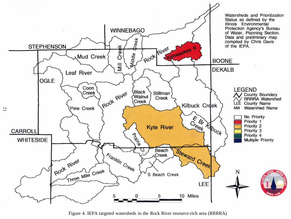
Figure 4. IEPA targeted watersheds in the Rock River resource-rich area (RRRRA)
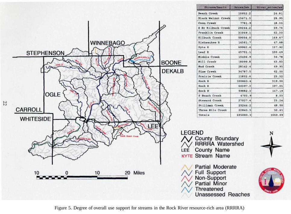
Figure 5. Degree of overall use support for streams in the Rock River resource-rich area (RRRRA)
REFERENCES
Allgire, R.L., and M. Demissie. 1995. Benchmark Sediment Monitoring Program for Illinois Streams: Program Summary and Site Descriptions. Illinois State Water Survey Circular 181. 56p.
Anderson, R.C. 1967. Sand and Gravel Resources along the Rock River in Illinois. Illinois State Geological Survey Circular 414. 17p.
Avery, C.F. 1994. Interaction of Ground Water with the Rock River near Byron, Illinois. U.S. Geological Survey Water-Resources Investigations Report 94-4034.
Bradbury, J.C. 1965. Dolomite Resources of Boone and DeKalb Counties, Illinois. Illinois State Geological Survey Circular 379. 22p.
Foster, J.W. 1956. Groundwater Geology of Lee and Whiteside Counties, Illinois. Illinois State Geological Survey Report of Investigations 194. 67p.
Frye, J.C, H.D. Glass, J.P. Kempton, and H.B. Williams. 1969. Glacial Tills of Northwestern Illinois. Illinois State Geological Survey Circular 437. 47p.
Gibb, J.P., M.J. Barcelona, S.C. Schock, and M.W. Hampton. 1984. Hazardous Waste in Ogle and Winnebago Counties: Potential Risk via Groundwater due to Past and Present Activities. Illinois State Water Survey Contract Report 336. 66p.
Hackett, J.E. 1960. Ground-water Geology of Winnebago County, Illinois. Illinois State Geological Survey Report of Investigations 213. 63p.
Hackett, J.E., and R.E. Bergstrom. 1956. Groundwater in Northwestern Illinois. Illinois State Geological Survey Circular 207. 25p.
Hanson, R. 1955. Groundwater Resources in Lee and Whiteside Counties. Illinois State Water Survey Report of Investigation 26. 67p.
Healy, R.W. 1979. River Mileages and Drainage Areas for Illinois Streams, Volume 1. U.S. Geological Survey Water-Resources Investigations 79-110. 350p.
Hunter, R.E., and J.P. Kempton. 1967. Sand and Gravel Resources of Boone County, Illinois. Illinois State Geological Survey Circular 417. 14p.
Illinois Department of Energy and Natural Resources. 1994. The Changing Illinois Environment: Critical Trends. Technical Report of the Critical Trends Assessment Project. Volume 2: Water Resources. Illinois State Water Survey, Champaign, IL.
Illinois Environmental Protection Agency Bureau of Water. 1993. Targeted Watershed Approach Utilized by the Illinois Environmental Protection Agency.
23
Illinois Environmental Protection Agency, Bureau of Water. 1994. Illinois Water Quality Report 1992-1993 Volume I. IEPA/WPC 94-160, Springfield, Illinois.
Illinois State Planning Commission. 1938. Report on the Rock River Basin in Illinois. State of Illinois.
Landsberger, S., P.K. Hopke, and B. Golchert. 1990. Determination of Heavy Metals on the Rock River through the Analysis of Sediments. Illinois Hazardous Water Research and Information Center. HWRIC Project 88-043, Champaign, Illinois.
Sasman, R.T., and W.H. Baker, Jr. 1966. Groundwater Pumpage in Northwestern Illinois through 1963. Illinois State Water Survey Report of Investigation 52. 33p.
State of Wisconsin. 1971. Lower Rock River. Department of Natural Resources Pollution Investigation Survey.
Telford, C.J. 1926. Third Report on a Forest Survey of Illinois. State of Illinois, Illinois Natural History Survey, Urbana, Illinois.
U.S. Bureau of the Census. 1936. Preliminary Reports on Illinois Agriculture by Counties. Washington, D.C.
U.S. Geological Survey. 1986a. National Water Summary - Illinois Surface-Water Resources. U.S. Geological Survey Water-Supply Paper 2300.
U.S. Geological Survey. 1986b. National Water Summary - Ground-Water Quality: Illinois. U.S. Geological Survey Water-Supply Paper 2326.
Viscocky, A.P., M.G. Sherrill, and K. Cartwright. 1985. Geology, Hydrology, and Water Quality of the Cambrian and Ordovician Systems in Northern Illinois. Illinois State Geological Survey and Illinois State Water Survey Cooperative Groundwater Report 10. 136p.
Walton, W.C. 1965. Groundwater Recharge and Runoff in Illinois. Illinois State Water Survey Report of Investigation 48. 55p.
Wehrmann, H.A. 1983. Potential Nitrate Contamination of Groundwater in the Roscoe Area, Winnebao County, Illinois. Illinois State Water Survey Contract Report 325. 108p.
Wehrmann, H.A., T.R. Holm, L.P. LeSeur, and CD. Curtiss III. 1988. A Regional Ground-Water Quality Characterization of Rockford, Winnebago County, Illinois. Hazardous Waste Research and Information Center RR027.
24


