Page 1
1
© Biosis 2012 – Leaders in Ecology and Heritage Consulting
Rockbank Precinct Structure Plan (PSP 1099) Historical Cultural Heritage Assessment Report.
Prepared for Growth Areas Authority
22 September 2013
Page 2
© Biosis 2013 – Leaders in Ecology and Heritage Consulting www.biosis.com.au i
© Biosis Pty Ltd
This document is and shall remain the property of Biosis Pty Ltd. The document may only be used for the purposes for which it was commissioned and in accordance with the Terms of the Engagement for the commission. Unauthorised use of this document in any form whatsoever is prohibited.
Disclaimer:
Biosis Pty Ltd has completed this assessment in accordance with the relevant federal, state and local legislation and current industry best practice. The company accepts no liability for any damages or loss incurred as a result of reliance placed upon the report content or for any purpose other than that for which it was intended.
Biosis offices
AUSTRALIAN CAPITAL TERRITORY
Canberra
Floor 1, Unit 3, 38 Essington Street Mitchell ACT 2911
Phone: (02) 6241 2333 Fax: (03) 9646 9242 Email: [email protected]
NEW SOUTH WALES
Sydney
Unit 14, 17-27 Power Avenue Alexandria NSW 2015
Phone: (02) 9690 2777 Fax: (02) 9690 2577 Email: [email protected]
Wollongong
8 Tate Street Wollongong NSW 2500
Phone: (02) 4229 5222 Fax: (02) 4229 5500 Email: [email protected]
QUEENSLAND
Brisbane
Suite 4 First Floor, 72 Wickham Street Fortitude Valley QLD 4006
Phone: (07) 3831 7400 Fax: (07) 3831 7411 Email: [email protected]
VICTORIA
Ballarat
506 Macarthur Street Ballarat VIC 3350
Phone: (03) 5331 7000 Fax: (03) 5331 7033 Email: [email protected]
Document information
Report to: Growth Areas Authority
Prepared by: Gary Vines
Biosis project no.: 16342
File name:
Citation: Biosis (2013) Rockbank Precinct Structure Plan (PSP 1099) Historical Cultural Heritage Assessment Report., Report for Growth Areas Authority. Authors: G Vines. Biosis Pty Ltd
Document control
Version Internal reviewer Date issued
Draft version 01 Gary Vines 18/5/2013
Final version 01 Gary Vines 22/9/2013
Page 3
© Biosis 2013 – Leaders in Ecology and Heritage Consulting www.biosis.com.au ii
Acknowledgements
Biosis Pty Ltd acknowledges the contributions of the following people and organisations in preparing this report:
• Sera Jane Peters, (Melton Heritage Advisor)
• David Moloney (Heritage Consultant co-author Melton Heritage Study)
• Jeremy Smith, Brandi Burgh (Heritage Victoria)
• Nat Anson (Growth Areas Authority)
Abbreviations
AAV Aboriginal Affairs Victoria (Heritage Services Branch)
AHC Australian Heritage Commission
AMG Australian Map Grid
BP Before Present
CHMP Cultural Heritage Management Plan
CHP Cultural Heritage Permit
SEWPAC Department of Sustainability and Environment, Water, Planning and Conservation
DSE Department of Sustainability and Environment (formerly DNRE)
DOI Department of Infrastructure
DPCD Department for Planning and Community Development
GAA Growth Areas Authority
HO Heritage Overlay
HV Heritage Victoria (DSE)
ICOMOS International Council on Monuments and Sites
LCC Land Conservation Council
PSP Precinct Structure Plan
RAP Registered Aboriginal Party
RNE Register of the National Estate
VAS Victoria Archaeological Survey (now part of AAV and Heritage Victoria)
Page 4
© Biosis 2013 – Leaders in Ecology and Heritage Consulting www.biosis.com.au iii
Contents
Summary ............................................................................................................................................................... vii
1 Introduction ..................................................................................................................................................... 9
1.1 Project Background......................................................................................................................................................... 9
1.2 Aims .................................................................................................................................................................................... 9
1.2.1 Location and Description of the Study Area ............................................................................................ 10
1.3 Consultation .................................................................................................................................................................. 10
1.3.1 Consultation with Heritage Victoria ........................................................................................................... 10
2 Background Information ............................................................................................................................. 12
2.1 Environmental Background ....................................................................................................................................... 12
3 Historical Background .................................................................................................................................. 15
3.1 Exploration & survey ................................................................................................................................................... 15
3.2 Squatters ........................................................................................................................................................................ 15
3.3 Selectors & settlers ...................................................................................................................................................... 17
3.3.1 J S Kelly ............................................................................................................................................................. 21
3.3.2 William Pratt .................................................................................................................................................... 22
3.3.3 Isaac and Henry Gidney ............................................................................................................................... 22
3.3.4 Missen Brothers ............................................................................................................................................. 23
3.3.5 Mark Paine ...................................................................................................................................................... 24
3.3.6 Martin Batey ................................................................................................................................................... 24
3.3.7 Edward Hall Pitson ........................................................................................................................................ 25
3.3.8 Dry Stone Walls .............................................................................................................................................. 25
3.3.9 Subdivision ...................................................................................................................................................... 26
3.4 Community & business ............................................................................................................................................... 26
3.4.1 Rockbank Primary School ............................................................................................................................ 26
3.4.2 Rose and Crown Hotel .................................................................................................................................. 29
3.4.3 Post Office & General Store ......................................................................................................................... 30
3.4.4 Mechanics Institute Community Hall ........................................................................................................ 31
3.5 Transport & industry ................................................................................................................................................... 32
3.5.1 Roads ................................................................................................................................................................ 32
3.5.2 Railway and station ....................................................................................................................................... 33
3.5.3 Local industry ................................................................................................................................................. 35
3.5.4 Wireless communications............................................................................................................................ 38
4 Previous assessments .................................................................................................................................. 41
4.1 Regional Surveys........................................................................................................................................................... 41
4.2 Dry Stone Walls Studies .............................................................................................................................................. 43
Page 5
© Biosis 2013 – Leaders in Ecology and Heritage Consulting www.biosis.com.au iv
4.3 Previously Recorded heritage places ....................................................................................................................... 48
4.4 Site Prediction Model .................................................................................................................................................. 49
5 Field Survey .................................................................................................................................................... 50
5.1 Methodology ................................................................................................................................................................. 50
5.2 Limitations/constraints ............................................................................................................................................... 50
5.3 Survey Results ............................................................................................................................................................... 50
5.3.1 Payne's Cottage .............................................................................................................................................. 51
5.3.2 Rose & Crown Hotel ...................................................................................................................................... 53
5.3.3 Mechanics Institute/Community Hall ........................................................................................................ 54
5.3.4 Pitson House ................................................................................................................................................... 55
5.3.5 Missen House ................................................................................................................................................. 56
5.3.6 Rockbank General Store & Post Office ..................................................................................................... 57
5.3.7 Rockbank Railway Station precinct ............................................................................................................ 58
5.3.8 School site ....................................................................................................................................................... 61
5.3.9 Beam Radio Receiving Station .................................................................................................................... 62
5.3.10 Dry Stone Walls .............................................................................................................................................. 63
5.3.11 Serbian Church ............................................................................................................................................... 67
6 Management Recommendations ............................................................................................................... 71
6.1 Recommendation 1 Site recording ........................................................................................................................... 71
6.2 Recommendation 2 Heritage conservation ........................................................................................................... 71
6.3 Recommendation 3 Permits and Consents ........................................................................................................... 71
6.4 Recommendation 4 Further investigations ............................................................................................................ 72
6.5 Report Lodgement ....................................................................................................................................................... 72
6.6 Independent Review of Reports................................................................................................................................ 72
Appendices ............................................................................................................................................................ 73
Appendix 1 – Assessment of Heritage Significance ........................................................................................ 74
Appendix 2 – Statutory Regulations ................................................................................................................. 78
Appendix 3 - Farming in the Melton District ................................................................................................... 81
Bibliography .......................................................................................................................................................... 85
List of Figures
Figure 1: Location of the study area. ................................................................................................................................ 11
Figure 2: Environment of the study area ......................................................................................................................... 13
Figure 3: Geological Survey of Victoria, sheet 8 (surveyed 1856) ............................................................................... 14
Figure 4: Plan of the allotments Rockbank Estate c 1853. ........................................................................................... 17
Figure 5: Plan of Crown Allotments, Parish of Kororoit (1892 County of Bourke Atlas State Library Vic) ......... 18
Figure 6: 1945 Aerial Photograph of the study area (Melbourne Uni Library) ........................................................ 19
Page 6
© Biosis 2013 – Leaders in Ecology and Heritage Consulting www.biosis.com.au v
Figure 7: Kororoit Parish Plan, Imperial measure 2927 ................................................................................................ 20
Figure 8: Pywheitjorrk Parish Plan, Imperial measure L7472 ...................................................................................... 21
Figure 9: Rockbank School, No. 919, photo Charles Edward Boyles (1888-1971) SLVH2008.122/365 .............. 27
Figure 10: Rockbank school children in 1956 during an excursion............................................................................ 28
Figure 11: Rockbank school shortly before demolition c 2002 (Photo D Moloney via Melton council) ............. 29
Figure 12: Rockbank Post Office and store in the 1970s, National Library B5191 ................................................. 30
Figure 13: Rockbank Store c 2000...................................................................................................................................... 30
Figure 14: 1 inch to 1 mile Ordnance survey, Sunbury Sheet, 1938, showing extent of roads and some dry
stone walls (thick black lines) .............................................................................................................................................. 33
Figure 15: Former Rockbank Station and signal box buildings, ................................................................................. 34
Figure 16: Plan of Rockbank station and sidings 1914.................................................................................................. 34
Figure 17: Plan of proposed verandah additions to Rockbank Station VR drawing 1924. ................................... 35
Figure 18: Plan of Cockbill's quarry and chaff mill siding ............................................................................................. 35
Figure 19: Victorian Railways, Reaping & Binding Hay at Rockbank Dec. 1953 with hay stook, SLV
H91.330/3422 ......................................................................................................................................................................... 36
Figure 20: Plan of Rockbank Station and Ward's Chaff Mill siding (VicTrack Sidings section) .............................. 37
Figure 21: Siding plan at Cockbill's Rockbank Chaff Mill (VicTrack Sidings section) ................................................ 38
Figure 22: Australian Wireless Beam Station. ................................................................................................................. 39
Figure 23: Rockbank Beam Wireless aerials .................................................................................................................... 39
Figure 24: Transmission lines connecting aerials to receivers at Rockbank. ........................................................... 40
Figure 25: Greigs Road dry stone wall precinct (Moloney et al) .................................................................................. 44
Figure 26: Payne's cottage from the east (photo David Moloney) ............................................................................. 51
Figure 27: Rase & Crown Hotel ........................................................................................................................................... 53
Figure 28: Rockbank Mechanics Institute/Community Hall ......................................................................................... 54
Figure 29: Pitson House ....................................................................................................................................................... 55
Figure 30: Missen House ..................................................................................................................................................... 56
Figure 31: Rockbank General Store & Post Office .......................................................................................................... 57
Figure 32: Rockbank Railway Station ................................................................................................................................ 58
Figure 33: Boxthorn marking chaff mill and house site (cistern immediately in front) ......................................... 59
Figure 34: looking across playing field to tennis court site (Serbian church on adjacent land) ........................... 60
Figure 35: Aerial photo of Rockbank Station Ground with historical features superimposed ............................ 60
Figure 36: Rockbank school site – view showing remnant planting .......................................................................... 61
Figure 37: Remains of painted game squares on concrete paths .............................................................................. 61
Figure 38: Radio Receiving Station .................................................................................................................................... 62
Figure 39: Dry stone wall at Paynes Road west side. .................................................................................................... 63
Figure 40: Dry stone wall at Paynes Road east side ...................................................................................................... 63
Figure 41: Dry stone wall at south side Greigs Road ..................................................................................................... 64
Figure 42: Dry stone wall at south side Greigs Road ..................................................................................................... 64
Figure 43: Dry stone wall at moderately intact wall on east side Leakes Road ....................................................... 64
Page 7
© Biosis 2013 – Leaders in Ecology and Heritage Consulting www.biosis.com.au vi
Figure 44: Detail of dry stone wall on east side of Leakes Road ................................................................................. 65
Figure 45: Detail of dry stone wall south side Greigs Road ......................................................................................... 66
Figure 46: Conserved dry stone wall near Hopkins Road (east of study area) ........................................................ 66
Figure 47: Serbian Orthodox Church ................................................................................................................................ 67
Figure 48: Map of heritage places ..................................................................................................................................... 70
List of Tables
Table 1: Dry stone walls sites within or near the study (Vines 1990b). ..................................................................... 43
Table 2: Dry stone walls in Melton study (Moloney et al)). ........................................................................................... 45
Table 3: Existing recorded heritage places in the study area ...................................................................................... 48
Table 4: Places outside the study area ............................................................................................................................. 48
Table 5: All recorded and additional heritage places in the study area .................................................................... 68
Page 8
© Biosis 2013 – Leaders in Ecology and Heritage Consulting www.biosis.com.au vii
Summary
Little appreciated by the motorists driving past on the freeway, Rockbank is a distinctive place with its own
history. While they might not be described as 'hidden jewels', Rockbank's historic places and heritage
features convey the character of the place, the stories of its past and present residents, and social,
environmental and economic factors which formed its development.
Biosis Pty Ltd was commissioned by the Growth Areas Authority (GAA) to undertake a heritage assessment
of historic heritage values in the Rockbank Precinct Structure Plan (PSP 1099).
The aim of this assessment is to examine the historical cultural heritage of the study area and to develop
recommendations to enable GAA to plan for future residential, commercial and infrastructure development
in the Rockbank precinct.
The study has compiled a thematic history of the precinct, which covers an area between Ballarat Road and
Greigs Road and from Paynes Road to just east of Troups Road.
In addition to the existing recorded places on the Melton Heritage Overlay, Heritage Inventory, and dry stone
walls recorded in a previous study, a number of other places of historic interest were recorded as part of this
assessment.
Management Recommendations
Recommendation 1 Site recording
A number of historical places were identified in the study. An update of the Heritage Inventory listing for the
Rockbank Station Precinct should be made to include evidence of former building sites, and the chaff mill.
Paynes Cottage, the Rose and Crown Hotel and the former Rockbank school site should also be assessed for
inclusion on the Heritage Inventory.
Recommendation 2 Heritage conservation
Places included on the Heritage Overlay and Victorian Heritage Register, should as far as possible, be
conserved and managed for their heritage values.
It is recommended that identified heritage places should be retained and conserved including Payne's
Cottage, the Mechanics Institute, Missen House, Pitson House and the Rose and Crown Hotel.
Dry stone walls in the precinct have been re-evaluated, and while the conclusions of the Melton Dry Stone
Walls study can be supported, the management of the walls in a changed land use context becomes
problematic. It may not be possible to retain the proposed Greigs Road dry stone walls precinct as open
pastoral landscape as recommended by Moloney et al, however, it may be possible to retain representative
sections of walls, with an appropriate curtilage and compatible land uses such as conservation reserves or
un-structured public open space.
As a reference point it is recommended that all dry stone walls are retained and conserved and that the
design of the future development of the Rockbank Precinct should take into account the walls, and
wherever possible provide compatible land uses such as unstructured open space, conservation reserves,
wide adjoining road verges, or allow retention of walls on frontage property boundaries by providing
alternative rear access.
Page 9
© Biosis 2013 – Leaders in Ecology and Heritage Consulting www.biosis.com.au viii
Where walls cannot be retained, or planning and design requirements require the removal of walls, decision
guidelines should be made on the basis of the assessment of significance of walls using the Melton Dry
Stone walls study and the assessment in the present study as shown in Figure 48, as a guiding principle.
Recommendation 3 Permits and Consents
Statutory approval should be sought for any places on the HO or VHI which are likely to be impacted by
future works.
A Consent to Disturb will be required for any works impacting on places listed on the Victorian Heritage
Register.
A Planning permit will be required for any works on places included in the Shire of Melton Heritage Overlay.
If or when the Melton Planning Scheme is amended to include the schedule of land covered by Clause 52.37,
a permit will be require for the removal of any dry stone wall. Where a permit is issued, it is recommended
that archival recording and documentation is carried out and authentic reconstruction of walls elsewhere is
carried out, reusing the dismantled stone. Preference should be given to retaining walls according the scaled
assessment in the Melton Dry Stone Walls Study and as shown in this report in Figure 48.
Recommendation 4 Further investigations
While it is unlikely that any further significant historical places of historic archaeological remains are likely to
be present in the study area, if evidence of such comes to light the place or object should be assessed by a
suitably qualified professional and if required, statutory protection be provided. Further investigation of any
of the listed heritage places should be carried out as part of any statutory approval or redevelopment
process.
Individual conservation management plans should be developed for the places listed on the HO and VHI,
and where disturbance of the site is proposed, detailed archaeological investigations should be undertaken
to identify the nature, extant and significance of any archaeological remains, and provide management or
mitigation for them.
Archaeological investigations should be undertaken of recorded historical and archaeological sites where
further information can be obtained. This is especially so with the School Site, Paynes Cottage, the Rockbank
Station Grounds and the Rose & Crown Hotel.
Page 10
© Biosis 2012 – Leaders in Ecology and Heritage Consulting www.biosis.com.au 9
1 Introduction
Cultural heritage legislation protecting historical heritage places applies in Victoria (Heritage Act
1995). These places are an important part of our heritage; they represent evidence of the more
recent period of settlement and contact with Aboriginal people.
Heritage places can provide us with important information about past lifestyles and cultural
change. Preserving and enhancing these important and non-renewable resources is encouraged.
It is an offence under sections of legislation to damage or destroy heritage sites without a permit
or consent from the appropriate body (see Appendix 2 for a complete discussion of relevant
heritage legislation and constraints).
When a project or new development is proposed, it must be established if any cultural heritage
places are in the area and how they might be affected by the project. Often it is possible to
minimise the impact of development or find an alternative to damaging or destroying a heritage
place. Therefore, preliminary research and survey to identify heritage places is a fundamental
part of the background study for most developments.
The first stage of a study usually incorporates background research to collect information about
the land relevant to the proposed development project (the study area). A second stage often
involves a field inspection of this area.
Possibly the most important part of the study involves assessing the cultural heritage significance
of heritage places in the study area. Understanding the significance of a heritage place is
essential for formulating management recommendations and making decisions.
The subject matter of this report involves the use of a number of technical words and terms with
which the reader may be unfamiliar. A glossary has been included at the end of the report and
reference to this may be of assistance.
1.1 Project Background
Biosis Pty Ltd was commissioned by the Growth Areas Authority (GAA) to undertake a heritage
assessment of historic heritage values in the Rockbank Precinct Structure Plan (PSP 1099).
The aim of this assessment is to examine the historical cultural heritage of the study area and to
develop recommendations to enable GAA to plan for future residential, commercial and
infrastructure development in the Rockbank precinct.
1.2 Aims
The following discussion is a summary of the major objectives. The major objectives are:
Document previously recorded historical archaeological sites within the study areas;
Predict the likelihood of archaeological sites as yet not recorded within the study areas;
Comment on the likely heritage values of the recorded and predicted site/values; and
Identify and comment on, with particular reference to the current project, relevant
Commonwealth and State heritage legislation (existing and proposed) and other
planning instruments.
Page 11
© Biosis 2012 – Leaders in Ecology and Heritage Consulting www.biosis.com.au 10
1.2.1 Location and Description of the Study Area
The Rockbank PSP is located 29 kilometres west of Melbourne, south of the Rockbank township
and Western Highway. The study area is bounded on the west by Paynes Road, south by Greigs
Road, north by the Western Freeway and the residential subdivision of Rockbank township, and
on the east the proposed Outer Metropolitan Ring Road alignment.
The study area is within the Parishes of Kororoit and Pywheitjorrk, County of Bourke in the City
of Melton.
1.3 Consultation
1.3.1 Consultation with Heritage Victoria
Before undertaking surveys for historical heritage places there is a statutory requirement to
notify Heritage Victoria – the State government agency responsible for historical cultural heritage
places. The protection and management of Aboriginal archaeological places and sites is
addressed under the provisions of the Aboriginal Heritage Act 2006 and Aboriginal Heritage
Regulations 2009
A ‘Notice of intention to carry out an Archaeological Survey’ was lodged with Heritage Victoria on
11/4/2013 in accordance with Section 131(1) of the Heritage Act 1995. Heritage Victoria assigned
4301 to the project).
Page 12
Rockbank
SHIRE OFSHIRE OFMELTONMELTON
Kororoit Creek
Adria
nCo
urt
Leak
es Ro
ad
Greigs Road
TaylorsRoad
Westcott Parade
Water
Rese
rveRo
ad
StewartCrescent
Beattys Road
Iramoo Circuit
Harrison Road
Wescott Parade
Murray Road
Faulk
ners
Road
Troup
s Roa
d Nort
h
Down
ing St
reet
Troup
s Roa
d Sou
th
Tarletons Road
Payn
es Ro
ad
WESTERN FREEWAYWESTERN FREEWAY
Acknowledgement: VicRoads© State of Victoria, Department of Sustainability and Environment, 2007
Matter: 16342Date: 27 May 2013,Checked by: GV, Drawn by: SKM, Last edited by: jshepherdLocation:P:\16300s\16342\Mapping\
LegendStudy Area
Scale 1:25,000 @ A4, GDA 1994 MGA Zone 55
0 250 500 750 1,000
MetresBiosis Pty LtdBallarat, Brisbane, Canberra, Melbourne, Sydney, Wangarratta & Wollongong
Figure 1: Location of the Activity Area - Rockbank,Victoria
Sunbury
Melbourne
Werribee
Dandenong
Melton
Whittlesea
Lilydale
Page 13
© Biosis 2012 – Leaders in Ecology and Heritage Consulting www.biosis.com.au 12
2 Background Information
2.1 Environmental Background
The study area lies on a basalt plain created by lava flows in the late Quaternary Period, 2 to 5
million years ago. Nearby Mt Atkinson and Mt Cottrell are among a number of eruption points in
the vicinity of the study area. From the eruption points, the lava flowed down river-valleys where
it hardened into basalt, covering the Ordovician and Silurian sediments. The soils on the basalt
plain are typically newer volcanic, with a heavy textured clay. This clay, 10 to 60 centimetres thick,
lies on the impervious layer of basalt and its poor drainage has led to the formation of the
swampy areas common to the volcanic grasslands. The study area lies entirely on the basalt
plain. 1
There are no major river-valleys in the study area, although the archaeologically significant
Kororoit Creek is approximately one kilometre to the northeast, at its closest point, and areas of
former and remnant swamplands occur south of Ballarat Road straddling Troupes Road and at
the eastern edge of the study area (note only the larger Troupes Road swamp is shown in the
early geological map above).
Outcrops of silcrete have been recorded on waterways in the region, including on the nearby
Kororoit Creek. It is almost certain that these sources of stone were utilised for artefact
manufacture and possibly as trade goods.
Moderately hot summers, with relatively brief dry periods, and cool, wet winters with few frosts
are characteristic of the western plains. Average temperatures range from a winter minimum of
5° to a summer maximum of 24°. Rainfall peaks in winter, with a yearly average rainfall of more
than 700mm.2
Before European settlement the dominant vegetation on the basalt plain would have been
Kangaroo grass (Themeda trianda Australis), with a number of other herbs and grasses, such as
Poa labillardieri and Danthonia spp, also present, particularly in the low-lying areas.3 The growth of
these grasslands may have been encouraged by the Aboriginal practice of systematic burning to
open up the land for hunting. Certainly, the local grassy plains and open woodlands were also an
important food source. Various edible leaves, fruits, and roots - including the staple root
Myrrnong (Microsis scapigera) - were all present on the plains. However, due to long term
cropping and pastoral activities, and more recently to the western movement of urban
development, grassland environments have been seriously degraded. Much of the study area is
now covered with introduced grasses and blackberry.
Riparian woodland and scrub would have been the predominant creek-side vegetation.
Waterways would have been thinly wooded with River Red Gum (Eucalyptus camendulensis), River
Bottlebrush (Callistemon paludosa) with rushes and reeds (Phragmites Australis) occupying the
saturated ground and creek-edges.4
1 Rosengren 1986:12
2 LCC 1991: 59-60).
3 McDougall 1987: 14).
4 McDougall 1987
Page 14
Rockbank
SHIRE OFSHIRE OFMELTONMELTON
Koror
oitCr
eek
Adria
nCo
urt Elizabe
thStr
eet
Greigs Road
IramooCircuit
Socrates Way
Westcott Parade
Leon
id Dr
ive
Murray Road
Stewart Crescent
Down
ing St
reet
Vere
Court
Troup
s Roa
d Sou
th
Wescott Parade
Taylors Road
Troup
s Roa
d Nort
h
Dean
side D
rive
Payn
es Ro
ad
Leak
es Ro
ad
WESTERN FREEWAYWESTERN FREEWAY
90m
90m
90m
90m
110m
110m
110m 110m
100m
100m
130m
110m
110m
130m
90m
90m
120m
120m
110m
90m
100m100
m
100m
110m
130m
120m
110m100
m
100m
110m
100m
130m
120m
110m
110m
110m
120m 120m
110m
110m
100m
90m
90m
90m
120m
120m
100m
120m
110m
110m
110m
110m110m
110m
100m
100m
110m 110m
110m
100m 100m
100m 100m 0 150 300 450 600 750
Metres
LegendActivity AreaCadastre50cm ContoursWetlands/swamps
Vegetation104 Lignum Swamp125 Plains Grassy Wetland132 Plains Grassland649 Stony Knoll Shrubland653 Aquatic Herbland654 Creekline Tussock Grassland68 Creekline Grassy Woodland895 Escarpment Shrubland
Matter: 16342Date: 27 May 2013, Checked by: GV, Drawn by: JMS, Last edited by: jshepherdLocation:P:\16300s\16342\Mapping\16342_F2_Environment
Biosis Pty LtdBallarat, Brisbane, Canberra, Melbourne,
Sydney,Wangaratta & Wollongong
Sunbury
Melbourne
Werribee
Dandenong
Frankston
Melton
Whittlesea
Lilydale
Scale: 1:15,000 @ A3
Figure 2: Environment of thestudy area
Coordinate System: GDA 1994 MGA Zone 55
Acknowledgements: Imagery (c) Nearmap 2012
Page 15
© Biosis 2012 – Leaders in Ecology and Heritage Consulting www.biosis.com.au 14
The basalt plains, and the Kororoit Creek, would have contained a wide range of fauna species
hunted by the Aboriginal people. Larger species, such as kangaroos, possum, wallaby, and emu
were common, although there may have been some seasonal variation, with higher numbers in
summer. Other species recorded at the time of European settlement, which have since largely or
wholly disappeared, included quolls, pademelons, and potoroos.5 The Kororoit Creek would have
been a particularly important resource for Aboriginal people, with freshwater mussels (Vesunia
Ambiguousa), fish, eels, waterbirds, lizards (such as the fat-tailed Dunnart), and small marsupials,
a reliable food source throughout most of the year.
Figure 3: Geological Survey of Victoria, sheet 8 (surveyed 1856)
5 LCC 1991:107).
Page 16
© Biosis 2012 – Leaders in Ecology and Heritage Consulting www.biosis.com.au 15
3 Historical Background
3.1 Exploration & survey
Hume and Hovell were probably the first to observe the basalt plains country north and west of
the future site of Melbourne in 1824, although Charles Grimes had mapped the coast of Port
Phillip Bay and ventured up the navigable sections of the Maribyrnong and Yarra Rivers in 1803.
The first white settlers in this area may have been John Batman's group of settlers. John Batman
parcelled out the land around Port Phillip Bay to the members of the Port Phillip Association. Two
of these people, Anthony Cottrell and Mr. Collicot, were allotted strips of land adjacent to the
study area which extended from the Maribyrnong River to the western edge of the basalt plains.
Cottrell gave his name to the nearby Mount Cottrell. While these settlers were not accorded legal
title to the land which Batman claimed to have purchased from the Aborigines, several of them
stayed on, including Joseph Solomon, Cottrell, Pinkerton and Robertson, who obtained squatting
licences in Melbourne's West with the eventual consent of the colonial Government.
The squatters who had an interest in land in the present study area, even if only for a few years,
were William Cross Yuille, James Pinkerton who occupied Kororoit Creek or “Chain of Ponds” for a
few years before moving to the Werribee River under pressure from Clarke’s Grass Right, James
Robertson, who kept a foothold on Jacksons Creek, Hyde and Desailly
William J T Clarke obtained a Special Survey of 140 square miles with a right to depasture stock
on an equivalent area of Crown Land in 1852.
The initial survey’s were conducted by Wedge and Darke in about 1838, defining the country into
a regular grid of 640 acre blocks (one mile by 1 mile), except where provision had to be made for
natural features and existing travelling routes. Natural features are rare in this district, Kororoit
Creek providing the only relief, and the previous route identified on the early plans as a track
‘from Upper Werriby (sic) and Pentland Hills to Melbourne’ ran roughly parallel to the existing
highway, but about a kilometre to the north.6
When the Crown Survey was undertaken, two roads were reserved to Ballarat, branching at
Hopkins Rd. One became the present highway through Melton while the other went south along
Greigs Road through Exford and on to the Bacchus Marsh. This Greigs Road route appears to
have been the main route in the 1860s, and its exceptional width of about 60 m or three chains,
was intended to accommodate droving livestock.
3.2 Squatters
Much of the land in the Melton-Rockbank area was sold at auction between June and December
1854. The rather dry nature of the country between Melton and Werribee appears to have
delayed settlement considerably and most of the land in the Parishes in the vicinity (Pywheitjorrk,
Maribyrnong, Kororoit and Derrimut) became part of the large pastoral estates of W.J.T. Clarke
and Simon Staughton. Staughton was Melton's second permanent settler, arriving in Melbourne
in 1841 and taking over Dr. John Watton's pastoral lease on the Werribee River (then known as
the Exe) in June 1842. He built his homestead at the junction of the Werribee River and Toolern
6 Parish of Kororoit, Central Plans Office
Page 17
© Biosis 2012 – Leaders in Ecology and Heritage Consulting www.biosis.com.au 16
Creek calling it Exford and accumulated large tracts of land in the Western Region as well as on
the Darling River in NSW.
W.J.T. Clarke obtained vast areas of the basalt plains through squatting licences, purchase at
auction and his special survey of 1850 in which he bought 31,375 acres stretching from Sunbury
to the Macedon Ranges. In addition to this he was able to claim 60,000 acres under a grass right
system for a short time before much of the remaining Crown land in the region was auctioned
off. In these auctions of the early 1850s Clarke purchased the largest proportion of the land in the
Rockbank area. Many blocks purchased by other farmers or speculators also became part of
Clarke's empire when they were resold. He had his mansion "Rupertswood" in Sunbury, but
owned land as far south as Werribee including the "Rockbank" and "Deanside" pastoral estates at
Rockbank. These estates were managed for grazing sheep and so beyond construction of
fencing, and the homestead and shearing shed blocks, little in the way of building of
improvements was carried out.
In the north east part of the study area, William Taylor was lord of the manor at his Overnewton
Estate. He arrived in Port Phillip in 1840 and had interests in other squatting runs before
purchasing the Overnewton lease in 1849. He also bought land in New South Wales and was
active in public affairs serving terms on the Victorian Legislative Assembly. Like the other
successful local squatters, he converted most of his leasehold to freehold at auction in the 1850s.
Clarke, Staughton and Taylor all would have grazed stock over the Rockbank area, prior to official
alienation in the 1850s as the boundaries of their grazing leases were poorly defined.
By 1880 the Overnewton Estate comprised 10,351 acres. The majority of the estate was
purchased by the Victorian Government for Closer Settlement farms established from c1905.7
William Cross Yuille was born in Scotland in 1819 and came to Port Phillip via Hobart in 1836. His
brothers William and Archibald Buchannan Yuille, established the Ballarat Run in 1838 while W. C.
travelled to New Zealand. He returned to Port Phillip in 1841 and established the Rockbank Run
in partnership with James Oliphant Denny, whose daughter he later married. Denny left the
partnership in 1846, selling his share to W.J.T. Clarke who later purchased the adjacent Rockbank
Run. Yuille was prominent in racing in the 1850s and 60s.8
The Rockbank grazing lease covered 11,361 acres in 1851. This included Sections 3,4,19,24, part
of Sections 8,23,25 & 26 and 422 acres of Portion 5,6,18 &29 Parish of Kororoit, and Section 22
and Part of Sections 23 and 1, Parish of Maribyrnong. His homestead was on CA 5A.9
Yuille purchased the pre-emptive right in 1853, but sold the property for £640 to the Melbourne
wine merchants Stewart & Brown on 15.4.1853 who erected the bluestone Rockbank Inn. Yuille's
homestead appears on a map dated 23.3.1852 as 2 buildings beside Kororoit Creek. John
Atkinson, a Port Fairy stone mason, died nearby in June 1852, and may have been working on the
construction of the Rockbank Inn. The Inn was probably designed by Charles Laing who is listed
as having worked on additions to the Inn in 1855 for the owner John Gray. Charles Beattie
(Beatty) rented the Rockbank Inn and 20 acres in 1863 and also farmed the area into the early
7 Peel:131; St. Albans 100 Committee 1998:9,45
8 Starr J. Melton Plains of Promise Melton Shire Council, n.d :15-20
9 Edith Popp Glimpses of Early Sunshine, 1979:30
Page 18
© Biosis 2012 – Leaders in Ecology and Heritage Consulting www.biosis.com.au 17
20th century, leasing some land from Clarke. He and his family held about 400 acres in the area
which was later sold to the Trethowans.10
3.3 Selectors & settlers
The 1860s Selection Acts were designed to open up of more Crown land for small farmers and
settlers. It subsequently led to development of communities. In the 1860s and '70s, Rockbank
had a general store, hotel, school, post office and other services, and then the railway station in
the 1880s which formed the nucleolus of a small but relatively stable community.
Section VIII was originally gazetted as a Village reserve, as it straddled the creek on a major track
to the Western District. Part was also a Limestone Reserve.
Figure 4: Plan of the allotments Rockbank Estate c 1853.11
Some of the slightly more arable land along Kororoit Creek and in what was known as ‘the Melton
Agricultural Area’, was reserved from sale in these early auctions, but leased and sold later under
the closer settlement schemes aimed at getting more farmers on the land. Prior to this few
people lived in the area, with occasional outstations of the big estates (such as Deanside) and
roadside inns and blacksmiths serving travellers. The most significant settlement in the area prior
to the late 1860s was the Rockbank Inn on Beatty’s Road.
By 1892, Clarke and Taylor had consolidated their holdings by buying up many of the other small
private blocks.
10 Paul McGuire, Inns of Australia, William Kelly, 1854, referred to in Starr J. Melton Plains of Promise Melton Shire
Council, n.d p.15, National Trust File; Miles Lewis Architect Index, University of Melbourne; Shire of Braybrook Rate
Books, 1891-2, 1897-7, 1906-7
11 Plan of the allotments "on the three chains wide roads leading from Melbourne to Ballaarat (Ballarat) and
Buninyong near the Koroit creek". 1853 or 1854 Note added in pencil: "Portion 5 + 6 Section 25" (of the parish of
Derrimut). : Series: Vale collection : http://handle.slv.vic.gov.au/10381/160103
Page 19
© Biosis 2012 – Leaders in Ecology and Heritage Consulting www.biosis.com.au 18
Figure 5: Plan of Crown Allotments, Parish of Kororoit (1892 County of Bourke Atlas State Library Vic)
The ruins of the former Rockbank pastoral homestead and outbuildings, which also served as the
Rockbank Inn, are located on west bank of Kororoit Creek south of Rockbank Middle Road, north
of the present study area. The remains of the Rockbank Inn and homestead are classified by the
National Trust and are listed on the Victorian Heritage Inventory.
Henry Beattie (Beatty) was former manager for John Aitken and leased 1,600 acres from Kaye and
Butchart who conducted a business in exporting sheep to New Zealand between 1860 and
1864.12
Rockbank village or township was a small nuclear community surrounded by farms, which in tern
formed an island of agriculture amidst the vast pastoral holdings of the Clarkes and Staughtons.
The ability of the land to support agriculture must have been recognised by the initial surveyor of
the district, possibly because the low lying swampy land near Kororoit Creek had allowed soil to
form on the otherwise bare rocky plains. Land was withheld from the first crown land sales in
sections 2-4, 6-8 and part of 5 and 18 in the Parish of Kororoit. When sold, the allotments were an
average of about 100 acres compared with the square mile lots (c.640 acres) of the pastoral
holdings. Sections 4 & 5 in Rockbank Parish and Sections 17 and 18 in Pywheitjorrk, make up the
present study area.
As the granting of land under the 1860s Land Acts was based on a progressive lease, the final
transfer did not occur for many years, so the dates of purchase recorded on parish plans are
generally a decade or so after the property was first settled, Land sales in Pywheitjorrk were sold
at earlier crown land auctions in the 1850s. Purchasers in the present study area are summarised
in the following table.
12 Priestly 1984:60
Page 20
Rockbank
Kororoit Creek
Adria
nCo
urt Elizabe
thStr
eetGreigs Road
Socrates Way
Westcott Parade
Leon
id Dr
ive
Taylors RoadFa
ulkne
rs Ro
ad
Stewart Crescent
Down
ing St
reet
Troup
s Roa
d Sou
th
Iramoo Circuit
Wescott Parade
Murray Road
Troup
s Roa
d Nort
h
Payn
es Ro
ad
Leak
es Ro
ad
WESTERN FREEWAY
WESTERN FREEWAY
0 150 300 450 600 750
Metres
LegendStudy Area
Matter: 16342Date: 26 March 2013, Checked by: GV, Drawn by: JMS, Last edited by: jshepherdLocation:P:\16300s\16342\Mapping\16342_HH_F2_1940_Aerial
Biosis Pty LtdBallarat, Brisbane, Canberra, Melbourne,
Sydney,Wangaratta & Wollongong
Sunbury
Melbourne
Werribee
Dandenong
Frankston
Melton
Whittlesea
Lilydale
Scale: 1:15,000 @ A3
Figure 6: Detailed plan ofActivity area showinghistorical features
Coordinate System: GDA 1994 MGA Zone 55
Acknowledgements: Imagery (c)
Page 21
© Biosis 2012 – Leaders in Ecology and Heritage Consulting www.biosis.com.au 20
Table 2. First landowners in the study area.
Purchaser Section Lot Sale date
Kororoit Parish
R Smith VII 4 16.3.70
Martin Batey III 6 27.8.75
George Missen IV 1 2a 3 4 4.4.73
George Missen Jnr IV 2b 14.11.74
George Missen III 3 5 18.8.76
George Missen III 7 8a 23.5.76
C McNamara IV 5 6 ?
W Pratt V 1-3 11.3.74
J S Kelly III 1A, 2 10.10.71
Pywheitjorrk Parish
J Mackintosh & JS Durie XVIII 1 7.7.54
W J T Clarke XVIII 2 7.7.54
J Clarke XVIII 3 24.2.54
John O'Grady XVII 1 7.7.54
J O'Grady & w Craig XVI 1 19.8.54
Figure 7: Kororoit Parish Plan, Imperial measure 2927
Page 22
© Biosis 2012 – Leaders in Ecology and Heritage Consulting www.biosis.com.au 21
Figure 8: Pywheitjorrk Parish Plan, Imperial measure L7472
By the 1880s a substantial community had developed at Rockbank, served by a hotel (the Rose
and Crown run by George Missen), school Blacksmith (Vere Quaile), post office and railway
station.
In 1892, Isaac Gidney held almost all the land on the north side of Ballarat Road at Rockbank,
while the Missen brothers had most of the land on the south. Leakes Road was then known as
Gidney’s Road north of Ballarat Road and Missen’s Road south of Ballarat Road. The Rose and
Crown Hotel was on a separate 10 acre block, the blacksmith and post office in the south east
corner of the intersection, Martin Batey farmed the block on the south west and the school
continued on the corner of Turner’s Lot 4 Section III.
3.3.1 J S Kelly
J. S. Kelly was granted Crown Allotments 1-3 Section V on 11.3.74. There are few references to
him and he appears to have resided in Bacchus Marsh, having in 1903, taken over the business of
Mr. C. Weston's boot shop, Bacchus Marsh,13 He is recorded in a number of Bacchus Marsh
stories with involvement at the Methodist church and was involved in cycle racing, so it seems
clear his land ownership in Rockbank was probably speculative.14 Kelly ultimately moved to
Ballarat in 1904.15 A Master Kelly is recorded at the Rockbank school in 190616 and a Mr Kelly had
a saddle and bridle stolen from his Rockbank property in 1901,17 so it is possible some of the
family resided in the district.
13 The Bacchus Marsh Express 7 Feb 1903: 2. Web. 3 May 2013 <http://nla.gov.au/nla.news-article90582295>.
14 "SATURDAY, 21st February." The Bacchus Marsh Express 21 Feb 1903: 2. Web. 3 May 2013
<http://nla.gov.au/nla.news-article90580435>.
15 The Bacchus Marsh Express 13 Feb 1904: 2. Web. 3 May 2013 <http://nla.gov.au/nla.news-article90582200>.
16 "MELTON." The Bacchus Marsh Express 6 Jan 1906: 2. Web. 22 May 2013 <http://nla.gov.au/nla.news-
article90165898>.
17 "MELTON." The Bacchus Marsh Express 16 Nov 1901: 3. Web. 22 May 2013 <http://nla.gov.au/nla.news-
article88352367>.
Page 23
© Biosis 2012 – Leaders in Ecology and Heritage Consulting www.biosis.com.au 22
3.3.2 William Pratt
William Pratt obtained several blocks south of the Ballarat Road east of Troup's Road naming his
property "Hilton Farm"..18
However, a William Pratt is recorded as having sold up and left the district in 1888.19 The auction
manifesto gives some clues to the nature of his farm and the activities he undertook, which might
be considered typical of the area.
.... William Pratt to SELL, on Monday, 20th June, at twelve o'clock, at Hilton Farm, Rockbank,
The whole of his stock &c.
Comprising 20 cows, milking 15 springers
1 Alderney bull
8 draught horses
2 Spring carts, 1 hay-dray
Stone dray, 2 ploughs, 2 sets harrows, chaff cutter,
grubber, roller, hay rake, harness, 8 tanks, building materials, 100 young fowls, large quantity dairy
utensils, sundries & co.
Luncheon provided.
No reserve.
The whole to be sold, In consequence of the sales of the property.
Sales by Auction. TUFSDAY, JUNE 20
At Twelve O'clock. 20
His grandson W. Drain, however, stayed in the district, and took over the blacksmith and
coachbuilder in Melton in 1911, previously run for 20 years by J. N. Byrnes, 21
Probably a different person, a William Pratt was one of 238 convicts transported to Sydney on the
Lord Petre, in 1843, but it cannot be confirmed if this is the William Pratt of Rockbank, although
the dates would allow so.22
3.3.3 Isaac and Henry Gidney
Isaac Gidney's property was one of the larger holdings in the Rockbank area in the late
nineteenth century located off Ballarat Road. However, no evidence of the original homestead is
visible. The Gidney dam and farm sites are recorded north of the Western Highway (H7822/0297
& 0300). Much of this property became the Defence Department's Royal Australian Signals radio
communication station north of Ballarat Road. Isaac and Henry Gidney also had several small
blocks in Rockbank, north of Ballarat Road. These comprised most of Sections VI and Lots 5 and 6
Section VII, as well as a scatter of other blocks near Kororoit Creek, which were probably used for
watering stock. They also leased land from other farmers. The total extent of their freehold
property was about 1000 acres. This land was selected under the Closer Settlement Act which
allowed for selection of Crown Land and payment over time, so that the brothers were not
actually granted title until 1873-4.
18 There may have been another William Pratt, as a William Pratt is recorded as having died at Hawthorn in 1880 -
William PRATT, b. 1816, Durham, Durham, England , d. 3 Nov 1880, Hawthorn, Victoria, Australia
http://wintoncameronfamily.dyndns.org/getperson.php?personID=I3284&tree=1
19 MELTON. (1888, June 30). The Bacchus Marsh Express p. 3. Retrieved May 3, 2013, from http://nla.gov.au/nla.news-
article89684436
20 "Advertising." The Argus 23 Jun 1888: 2. Web. 3 May 2013 <http://nla.gov.au/nla.news-article6135002>.
21 MELTON., The Bacchus Marsh Express 23 December, 1911p. 2. Retrieved May 3, 2013, from
http://nla.gov.au/nla.news-article90577853
22 Convict Records, http://www.convictrecords.com.au/convicts/pratt/william/96245
Page 24
© Biosis 2012 – Leaders in Ecology and Heritage Consulting www.biosis.com.au 23
Charles Gidney, Isaac's son, for a time leased land south of Ballarat Road, and also inherited the
family farm known as Rockbank Estate or Spring Farm, on his father's death in June 1894.23
Charles was shortly after sued for breach of promise of marriage by Eliza Jane Alp, who won
₤1,000 damages from him.24
3.3.4 Missen Brothers
The Missen brothers (George and Thomas) farmed land in the Rockbank area during much of the
second half of the nineteenth century and early 20th century (the family is still in the Melton
area). George and Mary Missen arrived in Victoria in 1867 and selected 150 acres. In 1871 George
Missen Snr. owned 229 acres in the Parish of Kororoit (Sec III lot 7 & 8) which included his
farmhouse. By the late 1870s George had been granted about 700 acres south of the Ballarat
Road. This included three smaller 5 acre blocks evidently subdivided from the main holding to
provide home sites for members of his family. This appears to have been reasonably common
around Rockbank with about a dozen such blocks, and was probably part of a Government
program of encouraging closer settlement in the area.
In later years he leased adjacent land from Martin Beatty including the lot with the old Rockbank
Hotel (Sec 4 lot 3). George lived at the old Rose & Crown Hotel (HO 121) on the Ballarat Road in
Rockbank until his death in 1883. His widow then moved into the house of her son (also George)
which was extended to accommodate the extra family.
The original bullock track to Melton and Ballarat used to pass through the farm near Mt. Cottrell,
the tracks of which were still visible in the late nineteenth century. By 1906 the farm had grown a
little. A descendent, Bert Missen, farmed and grazed sheep in the Truganina district in later
years.25
George Missen jnr, owned the land where the house at 1957-1963 Western Hwy was built by the
1890s.26 This had previously been granted to William Pratt in the initial land sales. From 1895-96,
the property is listed as including a 'house', and was leased out to Charles Gidney, of Rockbank,
as part of several thousand acres of property he owned or leased in Rockbank at this time.
Gidney continued leasing the property (it is doubtful that he lived in the house) until is was again
in the possession of George Missen by 1899. In 1901 the property was valued at ₤107.27 The
property had been subdivided by 1915-16 with a 'House and 109 acres' valued at ₤50, owned by
a Miss V Block and occupied by 'Thomas George Missen', and then owned by a Mrs M Malteira(?)
in 1929, then once again TG Missen in 1933.28 The Missen House (HO 120) is reputed to have
been:
'…where Frank and Reg Missen's father lived; he farmed it and was a very keen race horse follower'.29
He was a '…keen sportsman and lifetime owner, trainer, and driver of trotting horses'. The 'grand old
23 "WILLS AND ESTATES." The Argus 12 Jun 1894: 6. Web. 23 May 2013 <http://nla.gov.au/nla.news-article8676003>.
24 "A. BREACH OF PROMISE CASE." The Argus 14 Jun 1894: 5. Web. 23 May 2013 <http://nla.gov.au/nla.news-
article8676537>.
25 Shire of Braybrook Ratebooks 1871-2, - 1906-7; Starr J. Melton Plains of Promise Melton Shire Council, n.d 132-3
quoting Mary Missen's Diary; Albert Evans, Notes on Truganina LMW.
26 SLV Shire Map Series: 821A (1892)
27 Moloney 2006 citing Shire of Braybrook Ratebooks,
28 Moloney 2006 citing Shire of Braybrook Ratebooks,
29 Moloney 2006, citing Albert Evans, 'From the early settlers to the 1969 fires' (manuscript) site 114
Page 25
© Biosis 2012 – Leaders in Ecology and Heritage Consulting www.biosis.com.au 24
man' drove sulkies until in his late 70s, and continued his interest in the horses right up to his death in
the Footscray Hospital.30
In 1891, Robert Missen leased land on Ballarat Road Rockbank (crown allotment 4, Section 3,
2341-2421 Western Highway, Rockbank).31 The Missen Dam is recorded on this property (H7822-
029). At the same time Joseph Missen occupied the adjacent property which was farmed by
Walter Missen (senior) who owned most of the balance of this Section.32 John Turner had
previously owned the property, but there was no house on the site. This had been part of a
crown grant of about 103 acres under the Selection Act to an R. Smith, in February 1874.33 This
later became the long term residence of the Pitson family (HO 122) see below).
3.3.5 Mark Paine
Mark Paine34 arrived from Buckinghamshire England with his wife in 185935 and in 1863
purchased two allotments of land on the south side of Greigs Road on the corner of Greigs and
Paynes Roads where he erected a bluestone cottage (HO 113). By 1871 he owned 62 acres with a
stone cottage, selected 237 acres, and leased 223 acres.
Paine ran sheep, had a team of bullocks, carted goods and contracted for road work to the
Melton Roads Board. 36 He had also obtained a slaughtering licence.37
Paine was a long standing member of the Braybrook council for the Rockbank Riding and was
known by locals as ‘the King of Mount Cotterell’.38 He died in 1896.39
The Paine's Rockbank property eventually passed to a grandson, William Collins who married
Mary Nixon, daughter of Charles and Sarah Nixon of Mowbray, formerly the Sports Paddock, now
the Melton Golf Course. The Rockbank cottage had few amenities, a timber detached kitchen was
destroyed by fire. The building remained vacant for many years. Vandals removed windows and
doors and wrecked the building which was burnt in the 1965 fire.40
The current owner has repaired and reroofed part of the building.
3.3.6 Martin Batey
Martin Batey was a member of a prominent local family which had land interests across the
region from Melton to Sunbury. From 1846 to 1874 Martin Batey had a substantial grazing
property stemming from a squatting licence at Sunbury known as Redstone Hill, which he ran in
30 Tarr J. Melton Plains of Promise Melton Shire Council, n.d , J, p.118
31 Parish Plan, Parish of Kororoit. (It is possible that some of this land was selected by a son George).
32 Moloney 2006, Citing Shire of Braybrook Ratebooks and SLV Shire Map Series, 821A (1892)
33 Bob Macdonald, 'History of Melton', typescript, October 1969, p.6
34 Note the spelling of Paine and Payne seems to be quite variable in local records, although Moloney (2006) has
identified that in the Rockbank area, they refer to the same family and the spelling seems interchangeable in various
records. The Spelling 'Paine' has been employed here for the 19th century family, as this is more common, despite
the road having the Payne spelling. Payne's Cottage has been retained for the house built by Mark Paine, as this is
the one used in the Melton Heritage Study.
35 Olwen Ford, ‘Voices From Below: Family, School and Community on the Braybrook Plains 1854-1892’, M.Ed.
Thesis, University of Melbourne, 1993, p.248
36 Alex Cameron, ‘Melton Memoirs’ (M&DHS), p.22, and introduction.
37 Ford, 1993.
38 The Melton Express, 1/9/1896
39 Melton Express, 1/9/1896
40 Moloney 2006
Page 26
© Biosis 2012 – Leaders in Ecology and Heritage Consulting www.biosis.com.au 25
partnership with Frederick Nevison Flintoff. He purchased CA VII 6 west of Rockbank village, in
1875 under the closer settlement act. By the mid nineteenth century the property was in the
hands of Isaac Batey. Another member of the family (J.R.F.S. Batey) had 110 acres up the road
towards Melton.
Several smaller blocks of about 5 acres, were subdivided from these, evidently to accommodate
family members wishing to build their own houses on the family farm. Blocks north of the
present study area along Leakes Road were selected by D. Tarleton, J. Mawson, E. Butcher, J.
Matthews and G Missen, while within the Rockbank precinct study area, there were small blocks
at the corner of Leakes Rd and Ballarat Road, and the corners of lots 1a and 8a in Section III (Kelly
and Missen respectively).41
3.3.7 Edward Hall Pitson
In 1894 Edward Hall Pitson, described as a 'farmer' of 'Mt Cottrell', owned land on the south side
of Ballarat Road Rockbank, (crown allotment 4, Section 3, now 2341-2421 Western Highway which
was leased to Robert Missen .42 There does not appear to be any dwelling on the site until 1897-
98, when a 'hut' is recorded. Pitson moved to the property by 1898-99 which was referred to in
the rate books as 'Rockbank' which lists a 'house' on the site for the first time (HO 122). Pitson
continues to be listed as occupant until at least 1934.43 Edward was a councillor for Rockbank
Riding around 1916.44 He died on 27 November 1936, his executors being Sarah Helen Harris
and James Alfred Pitson, probably his children, then living in Thornbury and Scoresby
respectively.45
Little more is known of Edward Hall Pitson, although other members of the family get brief
mentions, including a young man, J Pitson, in a photograph of a Rockbank picnic,46 and ratebook
references to William Pitson, and Mary Pitson ('home duties, and was probably his wife), who had
land on the Exford Estate in the early twentieth century.47
3.3.8 Dry Stone Walls
Fencing was probably the first European construction on the Keilor- Werribee Plains. A settlement
founded by graziers ensured that the security of their livestock as a priority. The Fencing Act and
regulations governing land selection mandated the location and standard of fencing, requiring all
property boundaries to be fenced.
Stone was the most popular material where there was volcanic fieldstone scattered across the
ground, and few trees, although timber post and rail, hedges, post and wider and combinations
of all these were sued. Dry stone walls answered the need to clear the fields of rocks, particularly
where agriculture was envisaged, or to improve grass cover, and fence. In areas with fewer
stones, or near forests, early fences were more likely to have been timber post-and-rail, or post-
and-wire. With split timber from Mt Macedon and the Black forest being used by the 1860s.
41 Parish of Kororoit County of Bourke, Plan L5284, Department of Lands and Survey Melbourne 10.5.1873 (with
later annotations) State Library Victoria.
42 Parish Plan, Parish of Kororoit. (It is possible that some of this land was selected by a son George).
43 Moloney citing Shire of Melton Ratebook, 1933-34
44 MELTON. (1916, December 16). The Bacchus Marsh Express p. 2. Retrieved May 22, 2013, from
http://nla.gov.au/nla.news-article74271000
45 Advertising. (1937, February 25). The Argus p. 1. Retrieved May 22, 2013, from http://nla.gov.au/nla.news-
article11972918
46 Starr J. Melton Plains of Promise Melton Shire Council, n.d., p.120
47 Moloney citing Shire of Melton Ratebook, 1933-34
Page 27
© Biosis 2012 – Leaders in Ecology and Heritage Consulting www.biosis.com.au 26
However, the periodic fires across the grasslands were more likely to destroy post and rail
fencing, although stone walls were noted from early on as sometimes-effective fire breaks, and
so were purposely constructed around homesteads and livestock paddocks for protection.48
Therefore few early timber fences survive.
The main period of construction of dry-stone walls in Melbourne’s west was in the period 1850-
1880, after which improvements made wire considerably more economical than stone walling.
However, stone walls were still repaired, and a few new ones built, into the twentieth century.49
Wire fencing was introduced in the 1850s and was cheaper than either stone or post-and-rail
fencing, but did not really become popular, or an alternative for walling in very rocky areas, until
higher tensile steel and barbed wires were readily available from the 1870s or 80s.
Moloney notes that 45% of the dry stone walls remaining in Melton shire were erected as part of
the Clarke Rockbank pastoral estate, while three of the larger farmers built a further 21.5% of
walls between them - namely the Beattys on Blackhills Road (8.5%), Hopkins & Farragher on
Hopkins Road (7.4%), and the Moylans on Mount Kororoit Road (5.6%). A further third of the walls
were built mainly by smaller farmers and selectors, with, the Missens of Rockbank (3.3%), Payne
of Rockbank (3.2%), Campbell of Toolern Vale (1.6%), and Gidney of Rockbank (1.4%) the next
most prolific wall builders. With the spread of urbanization, many walls, especially along roads
and major property boundaries, have been replaced with wire fencing.50
3.3.9 Subdivision
In the early 1960s a large subdivision of about 140 allotments was carried out by a company
known as Rockbank Estates Pty Ltd. Most of the buyers appear to have been from the inner
western suburbs such as Newport and Sunshine looking for a small block, and many may have
been European migrants looking for larger blocks of land to build on. Moloney suggests they
were the vanguard of hobby farms and rural residential subdivision.51
A service station was constructed facing Ballarat Road in the middle of the subdivision, and a
service road provided. However, the service station was demolished about 10 years ago as access
to the residential parts of Rockbank was closed off from the main road.
3.4 Community & business
3.4.1 Rockbank Primary School
A Common School was built on the south side of Ballarat Road in 1868 to accommodate the new
families who were moving in to the area after land sales and establishment of farms.
Some dispute arose 6 years later when the site became swampy and sanitation deteriorated and
it was perceived to be distant from the main centre of population. A number of local residents,
including a Vere Quaile, who was prominent on the school committee petitioned for the school to
be moved and the newspapers reported that "An endeavor is being made by some persons to
48 Moloney, 2006, notes that many early farmers such as Chandler lost timber fences in the Black Monday fire
49 Vines 1995, Built to Last, Dry Stone Walls in Melbourne's Western Region.
50 Moloney Shire of Melton Heritage Study Stage Two, 2006: Environmental History.
51 Moloney Shire of Melton Heritage Study Stage Two, 2006: Environmental History. P.71
Page 28
© Biosis 2012 – Leaders in Ecology and Heritage Consulting www.biosis.com.au 27
get the New Cambridge School shifted from its present site to one nearer the Kororoit Creek."52
However, the Education Department seems to have been intractable.53
Figure 9: Rockbank School, No. 919, photo Charles Edward Boyles (1888-1971) SLVH2008.122/365
The land was gazetted in 1874 and the school became known a New Cambridge, eventually
coming under the Education Department as State School No 919.54 Local resident R. Smith, had
donated a one acre site, while Mary Missen recalled its early days:
‘The old school was built of stone carted by the local people. It was called ‘New Cambridge’ Number
919. There were a lot of children going then…There were a lot of houses about then and large families,
and that was the only school near them.’ 55
Mr. Saddler was the first teacher at the school, replaced by George Foster in 1871, who moved on
in 1876.56 New Cambridge operated half-time with Keilor Road Station school (No.1641) from
1884 to 1886 when Keilor Road was closed. Complaints as the unsanitary conditions continued,
52 "MELTON." The Bacchus Marsh Express 28 Jun 1873: 3. Web. 23 May 2013 <http://nla.gov.au/nla.news-
article93142663>.
53 "CORRESPONDENCE." The Bacchus Marsh Express 26 Jul 1873: 3. Web. 23 May 2013 <http://nla.gov.au/nla.news-
article93142256>.
54 Ford, O. Voices from Below, School and Community on the Braybrook Plains, 1854 to 1892. M. Ed. Thesis,
University of Melbourne 1993, pp.235ff.
55 Starr, J, Melton: Plains of Promise (Melton Shire Council, nd), p.117.
56 The Bacchus Marsh Express 4 Feb 1871: 3. Web. 23 May 2013 <http://nla.gov.au/nla.news-article89701836>. (Vic. :
1866 - 1918)
Page 29
© Biosis 2012 – Leaders in Ecology and Heritage Consulting www.biosis.com.au 28
for example from Missen and W. Murphy in 1885 complaining the school was not
whitewashed,57 and again by W. Murphy in 1886.58
A description of the school during Arbor Day described the site of the school as:
"…bleak and exposed, whilst the ground (as its name implies) was full of rocks and boulders. The
arrangements of the head teacher (Mr. E. J. Lyttle) were perfect, and the neighbouring residents had
willingly lent a hand. Forty two sizeable holes were sunk for the reception of the trees (! !) with incredible
difficulty to try and keep same in any sort of a line, owing to the rocks.59
In 1906 the name of the school changed to Rockbank and a teacher's residence was erected in
1934.60
Figure 10: Rockbank school children in 1956 during an excursion61
57 "The Council then sat as the." Independent 7 Mar 1885: 3. Web. 23 May 2013 <http://nla.gov.au/nla.news-
article73246883>.
58 "ANNUAL MEETING." Independent 11 Dec 1886: 4. Web. 23 May 2013 <http://nla.gov.au/nla.news-
article73767470>.
59 "ROCKBANK SCHOOL." The Bacchus Marsh Express 9 Jul 1904: 3. Web. 23 May 2013 <http://nla.gov.au/nla.news-
article90581244>.
60 Blake, pp.50-51, 72; Starr, . p.180
61 http://www.friendsreunited.co.uk/this-pic-was-taken-at-our-annual-sports-day-1956/Memory/25b5432b-ad07-
442e-9033-f5148ca3c08a
Page 30
© Biosis 2012 – Leaders in Ecology and Heritage Consulting www.biosis.com.au 29
Figure 11: Rockbank school shortly before demolition c 2002 (Photo D Moloney via Melton council)
In October 1998 the school celebrated its 130th Anniversary, with long needed maintenance
having been undertaken decades early.62
In 2009 the school moved with the old building on the Western Highway site being demolished
and a new school erected in Westcott Parade.
3.4.2 Rose and Crown Hotel
In April 1875 Thomas Missen obtained the licence for the Rose and Crown Hotel (HO 121) which
the family then ran as an adjunct to their farm. The hotel had eight rooms, in addition to
accommodation for the owners.63 George Junior ran the hotel up to 1885, after which it was
taken on by T. Derham of Braybrook, followed by A Coplestone in 1890-91, E. Keating in
December 1893, a Mrs O'Brien around 1898, and then William Derham. By 1911, the hotel was
'closed by order' of the License Reduction Board with 'Compensation of £320'.64 And a clearing
sale held as part of the change-over to new uses.65
The hotel was thereafter used as a residence by various Missen family members, followed by the
Harrison family and several others. In 1959 Mr and Mrs F Proud commenced operation of a 20
bay caravan park at the property incorporating an laundry and toilet pavilion and reticulation of
bore water to numerous taps, while trees were planted.66
62Public Records Office Victoria, VPRS 8796/P0001/Unit17, Capital Expenditure Works Files: Primary Schools, School
No.919: Rockbank Primary School, 1961-1978
63 The Melton Express, 28/10/1987 The Bacchus Marsh Express, 10/4/1875, 27/11/1875
64 Moloney 2006 citing Melton Express
65 "COMING AUCTION SALES." The Bacchus Marsh Express 23 Dec 1911: 3. Web. 23 May 2013
<http://nla.gov.au/nla.news-article90577870>.
66 The Melton Express, 3/7/1959.
Page 31
© Biosis 2012 – Leaders in Ecology and Heritage Consulting www.biosis.com.au 30
3.4.3 Post Office & General Store
Rockbank Post Office opened on 1 January 1862.67 This office was staffed in the first instance, by
Mr. James Fraser and situated close to the camping ground, six miles from Melton, between the
Rose and Crown and Mr. Pratt's Half-way house.68
Possible another general store is recorded as serving the Rockbank area from about 1861, run by
the Cropley family. While the Cropleys left to settle in Gippsland in the 1870s, other services came
into the area to serve the community.69
Figure 12: Rockbank Post Office and store in the 1970s, National Library B5191
Figure 13: Rockbank Store c 2000.70
67 Premier Postal History Post Office List https://www.premierpostal.com/cgi-
bin/wsProd.sh/Viewpocdwrapper.p?SortBy=VIC&country=
68 CORRESPONDENCE. (1872, January 13). The Bacchus Marsh Express p. 3. Retrieved May 3, 2013, from
http://nla.gov.au/nla.news-article89700818
69 Moloney Shire of Melton Heritage Study Stage Two, 2006: Environmental History citing Starr , p.132
70 Royce Millar $4bn plan to bust city's green corridor The Age, October 22, 2005, web -
http://www.theage.com.au/news/national/4bn-plan-to-bust-citys-green-corridor/2005/10/21/1129775961987.html
Page 32
© Biosis 2012 – Leaders in Ecology and Heritage Consulting www.biosis.com.au 31
The post office did not appear to last for long, as in about 1871a Mr Quale (who operated a
smithy in Rockbank), and some of the other residents were trying to get a post office.71 Mr. Sarre
(or Sarra) erected a new store on Station Road (now old Leakes Road) in 1909. It was described
as being "24 x 20, with 11ft walls, and big enough to do plenty of business," 72 He before when
he sold to new proprietors in 1911, when a Mr. H. Neilson took charge.73 The store was run by a
Mr. J. G. Orgill, in 1914 who was given permission to erect a branch store at the Exford weir. The
first telephone in Rockbank was also installed around this time, with "Mr. Charles Holden, son of
the Chairman of the Melbourne Harbor Trust, …the first in the district to have the 'phone on'."74
While the general store still operates on the same site, the building was extensively altered and
reconstructed about 10 years ago.
3.4.4 Mechanics Institute Community Hall
Rockbank gained a Mechanics Institute (HO 115) around 1920 as part of a movement which
flourished in Victoria from 1839 to 1950, having developed Institutes in Scotland and England
from the 1820s. Such institutions were intended to educate and enlighten the working classes,
with facilities including a reading room, a library and a lecture room. Although enjoying mixed
success in Britain, the made a substantial contribution to the development of public education
and library services in Victoria. 75
When the Rockbank Mechanics' was established the focus had changed from adult education to
community recreation or entertainment and the halls were used more for social functions and by
community groups. The reserves gazetted for Mechanics' Institutes between 1900 and 1930 were
increasingly being called 'public halls'. Rockbank Mechanics' Institute however, still incorporated a
library.76
Rockbank township, was not a Government surveyed township, and so land had not been
reserved for public purposes. The land was most probably either donated (perhaps by the locally
prominent George Missen family, who had previously owned the or purchased by public
subscription.77
The hall gained ancillary facilities, including a foyer, supper room and toilets, in more recent
decades. A Mr. Fogarty was the Secretary of the Institute for many years.78 The Hall was
purchased by the Shire of Melton in the 1980s from the Rockbank Mechanics' Institute and a
committee of management formed.79
71 Moloney 2006 citing Macdonald, p.9
72 "MELTON." The Bacchus Marsh Express 14 Aug 1909: 2. Web. 24 May 2013 <http://nla.gov.au/nla.news-
article90169192>.
73 "ROCKBANK." The Bacchus Marsh Express 30 Sep 1911: 3. Web. 24 May 2013 <http://nla.gov.au/nla.news-
article90577249>.
74 "ROCKBANK." The Bacchus Marsh Express 10 Jan 1914: 3. Web. 22 May 2013 <http://nla.gov.au/nla.news-
article74266403>.
75 Baragwanath, P, Hodgson, J, An Inventory of Mechanics' Institutes in Victoria, Vol.1 (DNRE, Historic Places Section,
September 1998), pp.iii-vi.
76 Baragwanath, Hodgson (1998), Vol.3, pp.841-842
77 Parish Plan, Kororoit; also Shire Map Series, Parish of Kororoit, 1892. See also Starr, J, Melton: Plains of Promise
(Shire of Melton, nd), pp.110 - 121
78 Moloney 2006 citing Mr Charlie Finch, pers. conv. 24/1/2002
79 Baragwanath, Hodgson (1998), Vol.3, p.841. Candy, Philip, 'Ex unitate vires: Mechanics' Institutes and the Federal
Ideal', in Baragwanath, P, If These Walls Could Speak: A Social History of the Mechanics' Institutes of Victoria
(Mechanics Institute Inc, Windsor, 2000), pp.3-5.
Page 33
© Biosis 2012 – Leaders in Ecology and Heritage Consulting www.biosis.com.au 32
3.5 Transport & industry
3.5.1 Roads
The Western Highway had its genesis as one of several possible routes to the western district.
However, as it was through open clay country, it could become impassable in winter. As a result
other routes either via Geelong or along the lower slopes of the ranges, through Sydenham and
Toolern Vale, or Beattys Road where the Rockbank Inn was places, were more common.
The three chain wide Griegs Road, which aligned with Rockbank Middle Road, to provide access
to a series of water reserves along Kororoit Creek, was a substantial stock route. The width of
both the Ballarat Road and Griegs Road was determined by the need to feed livestock while
droving between western district farms and Melbourne markets.
Improvements to the roads were generally undertaken by the Central Roads Board in the earliest
period1853-58, then by the District Roads Boards, which evolved into shire councils, and then
from 1913, the Country Roads Board (the precursor to VicRoads) took over responsibility for main
roads. Many roads in the district were constructed in a modified Telford method, using the field
stones to create a base of cobbles, raised above the natural ground level be digging ditches either
side and spreading the soil in a crowned embankment between. The cobbles were laid in this fill
and then given a wearing surface of gravel, crushed rock, sand, loam or whatever was to hand
apart from the sticky basalt clays.80
The first evidence of metalling the Ballaarat Road (as it was then called) was in 1854, several years
after the goldfields tracks had been turned to ruts and bogs.81 More extensive works amounting
to over ₤50,000, was undertaken in 1857, including substantial sections of corduroy and plank
roads, constructed where boggy conditions were causing problems.82
In 1871 WJ Clarke was elected to Melton Shire Council, and later became President, and his
influence may have led to improvements in Rockbank roads, while a new stone and timber
bridge over Kororoit Creek in Deer Park, built in 1878 saw Rockbank on the main route to
Ballarat.83
Braybrook Roads Board was formed in 1860, then a Shire in 1871 and had responsibility for
roads between West Footscray and Melton. It constructed the bridges along Ballarat Road
including Kororoit Creek, Johns (or Jones Creek) and Keating's Swamp.84 Keating's Swamp was
named for local resident, John Dalrymple Keating, purported to be the first European child born
in Tasmania, who died at Rockbank in 1888.85 It was also where a 'strange animal' with ‘with a
round stubby, black head …’ was seen travelling about when the swamp was overflowing in 1863.
‘Some said it must have been a Bunyip’, according to Anders Hjorth.86
80 Max Lay, Melbourne Miles, The Story of Melbourne's Roads
81 Victorian Government Gazette, No 94, Oct 16, 1854, p. 2295
82 For example Victorian Government Gazette no 104, , November 14th 1854 p.2543
83 Bilszta, J ‘The First Shire Council’, unpublished typescript (MDHS, nd)
84 "Advertising." The Bacchus Marsh Express 20 Apr 1878: 2. Web. 26 May 2013 <http://nla.gov.au/nla.news-
article89702300>.
85 The Mercury (Hobart, Tas. : 1860 - 1954) Monday 1 September 1884.
86 Moloney 2006 citing Hjorth, Anders, ‘Recollections of Melton 1861-67’, in M&DHS Newsletter, February 2001.
Page 34
© Biosis 2012 – Leaders in Ecology and Heritage Consulting www.biosis.com.au 33
Figure 14: 1 inch to 1 mile Ordnance survey, Sunbury Sheet, 1938, showing extent of roads and some dry
stone walls (thick black lines)
Under the CRB Ballarat Road was greatly improved and in the 1960s was designated a Bypass
Road with limitations on who could access it. Grazing of livestock along the verges was
prohibited. In the 1960s and 70s it was progressively duplicated, often eliminating early homes
and other buildings built at the road junctions where widening of the otherwise generous road
reserve was necessary.
One of the improvements was the planting of shelter belts of vegetation along the road side, in
the early twentieth century, in particular the extensive sugar gum plantations. On the Western
Highway at Rockbank an interesting plantation of different species of pine trees was created in
parts of the median strip and southern verge. Some of these are believed to have been planted
by state school children as part of a beautification exercise.87
Planting along the southern and western sides of roads was more common, as this protected
against the prevailing winds in what was a very open landscape, sometimes known as "Pleurisy
Plains".
3.5.2 Railway and station
A major change to Rockbank occurred in the 1880s when the North Western Railway was
constructed linking Sunshine to Ballarat through Melton and Bacchus Marsh. This meant the
creation of a railway reserve, through the existing Crown Allotments and eventually forcing the
realignment of the eastern end of Greigs Road to avoid an extra level crossing.
87 Robert Macdonald, ‘A History of Melton’, typescript held by MDHS, c.1969, p.17
Page 35
© Biosis 2012 – Leaders in Ecology and Heritage Consulting www.biosis.com.au 34
The Rockbank station (D7822-030) was provided with a waiting sheds, residences for station staff,
a signal box and later more substantial station building.88 Three roads (the main rail track and
two loop sidings) were provided, with the chaff siding running north off No 3 Road (H7822-0717).
Figure 15: Former Rockbank Station and signal box buildings,89
Figure 16: Plan of Rockbank station and sidings 1914. 90
The opening of the Ballarat railway in the 1880s which required considerable earthworks through
Keatings Swamp, may have been instrumental in the establishment of the coursing ground at
Rockbank.91
A recreation reserve was created just south of the railway, apparently using residual land
acquired for the railway and station easement. This later was planted with sugar gums and other
trees, and a rough playing field, tennis courts, toilets and other facilities were created.
88 Andrew Ward, A. Donnelly, Victoria's Railway Stations: An Architectural Survey, 1982; A Study of Historic Railway
Buildings and Structures for V Line, Vol. 4, Andrew Ward and Associates, 1988 p 588
89 Where there were stations blog http://www.stationspast.net/victoria/rockbank-to-ballarat/rockbank/
90 Andrew Waugh, Victorian Siding Histories http://www.vrhistory.com/Locations/A019-Rockbank.pdf
91 Victorian Municipal Directories, 1919
Page 36
© Biosis 2012 – Leaders in Ecology and Heritage Consulting www.biosis.com.au 35
Figure 17: Plan of proposed verandah additions to Rockbank Station VR drawing 1924.
3.5.3 Local industry
A number of local industries were established, partly due to the convenience of the railway line.
These included chaff mills, and a quarry.
J. Cockbill operated a quarry located east of Paynes Road and south of the railway from at least
1925. It was served by a siding which would have facilitated stone carting on a track on the south
side of the railway line. The siding was opened on 27 Feb 1925, and disconnected in 1940, after a
few modifications in the mean time. A hopper for receiving stone for loading on wagons was
located across the middle of the siding.92 This siding also served Cockbill's chaff mill. The quarry
hole was subsequently filled.
Figure 18: Plan of Cockbill's quarry and chaff mill siding93
According to Moloney, there was a shell of a concrete building located about 500 metres east of
Paynes Road, immediately adjacent to Cockbill's quarry. There was also an identical pair of semi-
92 Andrew Waugh, Victorian Siding Histories http://www.vrhistory.com/Locations/A019-Rockbank.pdf
93 Andrew Waugh, Victorian Siding Histories http://www.vrhistory.com/Locations/A019-Rockbank.pdf
Page 37
© Biosis 2012 – Leaders in Ecology and Heritage Consulting www.biosis.com.au 36
ruinous concrete houses on the east side of Paynes Road, about 150 metres south of the
railway.94
Growing hay and chaff milling was an important local industry which was particularly suited to
the dry western plains, especially between Werribee and Melton, where fertile soil, adequate rain
falls, and long, warm, dry summers allowed the hay to ripen and dry. Stooks of straw, traditional
haystacks, and large chaff mills were a feature of the district until recently. Shipment of hay and
chaff were the main reasons for a station at Rockbank, and a substantial station ground and
sidings were installed as a result. At least two chaff mills were erected beside the line.
The first Rockbank chaff mill (H7822-0717) was built in 1908 by the Barrie Brothers opposite the
railway station and its machinery brought from Melton by horse and dray.95 Moving large
machinery and buildings appears to have been something of an accomplished art for the Barries
as they were also responsible for moving their Djerriwarrh home to Ferris Lane Melton by truck
in 1941,96 and Jack Findlater's house from Rockbank to Footscray West.97
The Barries sold to Glover, Onians & Co. in 1910,98 but the Barries seem to have either bought
back into the mill, or built another one, as they are recorded as having sold the business to Dixon
Brothers in 1916.99 Hill and Reid, chaff-millers who operated from King Street Melbourne in 1915,
had an interest in the mill at some stage although when and how they were involved is not
known. 100
Figure 19: Victorian Railways, Reaping & Binding Hay at Rockbank Dec. 1953 with hay stook, SLV
H91.330/3422
94 David Moloney, pers. com, 22/5/13
95 Recorded interview with Leo Tarleton, 6.2.87 LMW; Starr J. Melton Plains of Promise Melton Shire Council, n.d .;
Much of the information on Chaff Mills is from Gary Vines,, Chaff-Mills In Melbourne's West An Industrial Sites Study
1987, Living Museum of the West. https://www.researchgate.net/profile/Gary_Vines/publications/
96 Starr J. Melton Plains of Promise Melton Shire Council, n.d p.217.
97 Recorded interview with Jack Findlater, 5.2.87 Living Museum of the West
98 "MELTON." The Bacchus Marsh Express ) 19 Feb 1910: 2. Web. 23 May 2013 <http://nla.gov.au/nla.news-
article90171788>.
99 MELTON. (1916, February 5). The Bacchus Marsh Express p. 2. Retrieved May 23, 2013, from
http://nla.gov.au/nla.news-article74269649
100 Lists of dismantled private sidings, Indexes, held by Sidings Administration Section, V Line Melbourne.
Page 38
© Biosis 2012 – Leaders in Ecology and Heritage Consulting www.biosis.com.au 37
H.S.K. Ward trading as Glover Onians and Co. also bought this mill around the same time as the
Melton mill and constructed a siding in 1914, which was extended in 1915. The manager was
Archie McEacherchen.101
By 1 July 1955 the mill appears to have been out of action as Victorian Railways were using the
siding and waived the annual maintenance charge. In 1959 the siding was purchased by the
railways.102 The Rockbank mill also burned down.
Figure 20: Plan of Rockbank Station and Ward's Chaff Mill siding (VicTrack Sidings section)
Another chaff-mill operated in Rockbank for a short time. This was established in 1925 by G.
Cockbill who leased land from the railways for a chaff-cutting business and a siding. It continued
until 1931 when the points and crossing were removed and the site appears to have been vacant
for some years. In 1936 the siding was reconnected by J. Hocking and Sons (Hay, Corn, Chaff,
Wood and Coal Merchants of Dandenong Road, Malvern and Nepean Road, North Brighton.) who
later sold out to Hay Products Pty. Ltd. They in turn ceased business about 1940 and the siding
was again disconnected. On 16.6.72 an inspection by railway staff revealed no evidence of the
siding or a business on railway land.103 The Company ceased on 21. 12. 1919.104
In 1909 Glover Onians and Company operated in partnership with H S K Ward, operated as grain
and produce salesmen 54-60 King St Melbourne. This was the last record of the firm until it was
struck off the Resister of Businesses in July 1929.105
101 Starr J. Melton Plains of Promise Melton Shire Council, n.d. and Leo Tarleton, 'Summary of chaff-mills in the
Melton area, copy held by LMW.
102 Lists of dismantled private sidings, No. 128, Ward, held by Sidings Administration Section, V Line Melbourne.
103 Lists of dismantled private sidings, No. 129, Cockbill, held by Sidings Administration Section, V Line Melbourne.
104 Defunct Business File, 933/44/14204, Victorian Public Records Office
105 Defunct Business File 933/1/2, Victorian Public Records Office.
Page 39
© Biosis 2012 – Leaders in Ecology and Heritage Consulting www.biosis.com.au 38
Ward appears to have continued in the chaff-milling business on his own from this time until
1946 when he formed a proprietary limited company.
Figure 21: Siding plan at Cockbill's Rockbank Chaff Mill (VicTrack Sidings section)
3.5.4 Wireless communications
The Australian Government, as part of its role in controlling radio and telegraph communications
for the commonwealth determined that a direct radio service would be required with the UK – as
an adjunct to the telegraph system which operated via submarine cables.106
While the prime task of the newly formed AWA had been to develop wireless for shipping in the
Australian region, from 1923 it became the designer, builder and supplier of Australia's first radio
broadcasting stations' transmission equipment, and a pioneer of long-distance radio. The
Commonwealth government invested in the firm and in 1926, it established two large beam
wireless stations on 180 hectare sites; a receiver site in Victoria at Rockbank (HO 108 located
outside the Rockbank precinct) and a transmitter site at Fiskville near Ballan. The shortwave
radiotelegraph service between Australia and Britain was inaugurated on 8 April 1927 and
terminated on 31 May 1969.107
106 Ian McLean, ‘Rockbank, Fiskville and the Beam Wireless, Part 2’, in HRSA Radio Waves, July 2004, pp.12-13; also
Caslon, Australasian Telecommunications Profile: History (Caslon) www.caslon.com.au/austelecomsprofile1.htm
107 Inglis, KS, ‘The Beginnings of Radio in Australia’, Stirling Memorial Lecture 1980; 750 Australian Academy of
Technological Sciences and Engineering, Technology in Australia 1788-1988, (Melbourne 1988, On-line 2000), p.536
Page 40
© Biosis 2012 – Leaders in Ecology and Heritage Consulting www.biosis.com.au 39
Figure 22: Australian Wireless Beam Station.108
Figure 23: Rockbank Beam Wireless aerials
The Second World War saw the establishment of the Defence Department radio receiving station
which took up much of Gidney’s land north of Ballarat Road. As part of this development a
number of radio masts and service buildings were erected, and a group of defence personnel
houses built at the north east corner of Leakes Road and Ballarat Road, with a new street
108 Wireless Telegraphy in Australia web viewed 23/5/13 http://www.angelfire.com/de/vk3kcm/Fiskville2.html
Page 41
© Biosis 2012 – Leaders in Ecology and Heritage Consulting www.biosis.com.au 40
constructed. It was probably at this time that Gidney’s original house was demolished, it evidently
having been located where the new houses were built.109
The increase in personnel from the radio and defence facilities increased the need for reticulated
water, and local recreational facilities. A number of defence houses were also constructed near
the corner of Leakes Road and Ballarat Road.
Figure 24: Transmission lines connecting aerials to receivers at Rockbank.110
109 THE HISTORY OF SHORTWAVE RADIO IN AUSTRALIA 1942 - Army Wireless Chain - west of Melbourne,
http://bpadula.tripod.com/australiashortwave/id68.html
110AWM 051993 Irving, Robert Bruce, ROCKBANK, VIC. 1943-05-24. "Transmission Lines Connecting Double-Dipole
Aerials To Their Respective Receivers At The Station of Land Headquarters Heavy Wireless Group At Rockbank. These
Lines Connect The Aerial Array To The Various Receivers.
Page 42
© Biosis 2012 – Leaders in Ecology and Heritage Consulting www.biosis.com.au 41
4 Previous assessments
4.1 Regional Surveys
The study area is located in the Keilor - Melton Basalt Plains grassland, a region which is has seen
a combination of sparsely settled pastoral stations and small areas of closer settlement from the
mid nineteenth to mid twentieth centuries. It is only in the last 40 years or so that more intensive
development has occurred.
Archaeological and heritage investigations have also only occurred since the 1980s, with most
investigations having been undertaken in the last decade or so. The primary heritage assessment
has been the Melton Heritage Study, undertaken by David Maloney and completed in 2006. In
addition to the published information, data on potential heritage places was compiled in early
stages of the project and kept on file by Melton Council. This study identified a number of
buildings around Rockbank resulting in Heritage Overlay protection for five places in the current
Rockbank PSP area.
Until early 1989, very little systematic archaeological survey had been carried out in Melbourne's
Western Region. Gary Presland's 1983 Melbourne Metropolitan survey111 stopped short to the
east of the study area. Since then there have been archaeological surveys of the Maribyrnong
River, Sydenham and Werribee Growth Corridors, Werribee River, several specific development
sites and the region in general.112 Most of these however, concentrated on or were exclusively
for Aboriginal archaeology.
On the eastern border of the study area Vines conducted an archaeological study for the Melton
East Structure Plan.113
A Survey of Department of Defence land at Rockbank immediately north of the present study
area.114 During the survey two new historical archaeological sites were located near the junction
of Beatty’s Road and Kororoit Creek. The sites were recorded as Rockbank Inn H7822/257 and
Beatty’s Bridge H7822/258. The location of both sites are considered to be of high historic
archaeological sensitivity, particularly at Rockbank Inn where archaeological material is expected
to pre-date the 1850s. Murphy assessed areas that may potentially contain dry stone walls to be
of moderate archaeological sensitivity.
Murphy and du Cros conducted a desktop study of the Kororoit Creek from Princes Highway,
Laverton North to Deanside Drive, Rockbank.115 Ten post-contact sites had previously been
recorded within the study area. The sites belong to either the early pastoral or industrial period;
1840 – 1880s. The pastoral sites are typically farm ruins, stone walls and fords. The industrial
111 Presland, Gary, An archaeological survey of the Melbourne Metropolitan area Victoria. Ministry for Planning and
Environment, Victoria Archaeological Survey 1983.
112 Presland 1983; Keys & Keys 1977; du Cros 1988, 1989a 1989b; du Cros and Golding 1989; Clark 1995; Murphy &
du Cros 1994; Murphy 1998; Egloff 1988; Vines 1988, 1990b, 1992a, 1992b, 1993a 1993b; Rhodes 1999; Muir et al
1996
113 Vines G(1990 Melton East Structure Plan.
114 Murphy 1998 Department of Defence land at Rockbank, archaeological assessment, report to department of
defence
115 du Cros 1994 'Desktop archaeological assessment of Kororoit Creek from Princes Highway, Laverton North to
Deanside Drive, Rockbank.'
Page 43
© Biosis 2012 – Leaders in Ecology and Heritage Consulting www.biosis.com.au 42
sites within the study area are those associated with the manufacture of explosives such as
chemical storage and treatment tanks.
Newby and Muir surveyed the intersection of the Western Freeway and Hopkins Road. No new
historic archaeological sites were recorded during the survey, nor were any areas of
archaeological potential recorded.116
During a survey Hopkins Road interchange four new historic archaeological sites were
recorded.117 Site H7822/0245 is a remnant old cobbled roadway that survives along a
discontinued route of Greigs Road. Only 120 metres of the road survives, but Vines suggests it
may survive under the bitumen surface of a continuation of the road. Site H7822/0246 is a
farming property originally established by the Cropley (or Croppley and sometimes mistakenly
Crossley) brothers in the 1850s and known as Stoneleigh. H7822/0247 is a drystone wall running
around the original boundaries of the Cropley property. H7822/0248 is another dry stone wall.
Historical archaeological sites are generally associated with early farm complexes and foci of
settlement such as the hotels and creek crossings. The Rockbank Inn, Beatty’s Bridge and a
number of early homestead sites have been previously identified in several studies.118 Dry stone
walls are among the most extensive historical features in the landscape, but are succumbing to
various factors that are diminishing them, removal by farmers, re-fencing, stone robbing and new
development. The Caroline Springs development to the east included an archaeological
investigation of a section of cobbled road flanked by dry stone walls.119
An archaeological survey of the junction of the Western Highway and Leakes Road recorded a
number of historic buildings and historic features including a c1910 weatherboard cottage and
shop, a c1910 weatherboard house (since demolished) and a weatherboard hall from the
interwar period, all of which are located on Leakes Road south, the Rose & Crown Hotel, a
bluestone hotel from c1870 located on Ballarat Road, as well as two dams, Gidney Dam and
Missen dam, dry stone walls and Gidney Farm, which is a complex of ruins and archaeological
features.120 The Rockbank Railway Station consists of the remains of platforms and asphalt
tennis courts, the buildings have been demolished, but archaeological evidence of several
structures and other remains can be identified. A number of radio mast bases were also
identified in the Defence Department Land.
At the southern end of the study area Muir (2002) conducted a cultural heritage survey of a
proposed primary school site at Rockbank. No non-Aboriginal archaeological sites were identified
during the survey. Due to high level of ground disturbance Muir did not identify any of the site as
having potential for non-Aboriginal archaeological material.
On the eastern border of the current study area Vines (1990) completed a historical and
archaeological survey for the Melton East Structure Plan Study area. A number of non-Aboriginal
historical archaeological sites were recorded during this study. Four of these sites are located to
the east of the present study area adjacent to one of the major tributaries of Kororoit Creek. The
sites included, a 1920 homestead site, farm and house ruins, basalt cobblestones and dry stone
walls, farmhouse and drystone walls, and cypress trees. The report suggests that further such
116 Newby, J. and Muir, S. 1998. Western Freeway and Hopkins Road, Archaeological and Heritage Investigation of
Proposed Restoration Roads.
117 Vines, G., 1993a, Hopkins Road Archaeological Survey, Report to Gutteridge, Haskins & Davey and VicRoads.
118 Vines 1990a, 1992a, 1992b, 1993a & 1993b; Murphy 1998
119 Lane and Rhodes 1999
120 Vines, G., 2000, Leakes Road Archaeological Survey, Report to Sinclair Knight Merz on behalf of VicRoads
Page 44
© Biosis 2012 – Leaders in Ecology and Heritage Consulting www.biosis.com.au 43
farm associated sites will be recorded throughout the region, particularly close to the creeks,
tributaries and drainage lines.
4.2 Dry Stone Walls Studies
A study of dry stone walls in Melbourne’s Western Region, identified a number of stone walls in
the present study area.121 However, this was not a comprehensive survey so not all dry stone
walls in the present study area will have been recorded. Walls were identified at two levels:
selected walls were documented with a pro forma indicating function, construction form,
construction technique, dimensions, stone type and size, condition, integrity and other features,
while other walls were recorded according to a simplified code indicating height, condition and
technique.
Walls identified in or adjacent to the present study area include the following:
Table 1: Dry stone walls sites within or near the study (Vines 1990b).
Wall Ref.
No./ code
Wall type and
condition
Location Current status
018 Prominent large wall Leakes Road North of study area
on opposite side of Ballarat Road
Demolished for
interchange
1.3.2 Low well preserved wall North side Greigs Rd. east of
Leakes Rd.
Poor
1.3.2 Low well preserved wall east side Leakes Rd. north of
Greigs Rd
Poor
1.2.3 Low well preserved wall property boundary north and east
of above
Fair
2.2.2 Partly collapsed low
wall
South side Greigs Rd Road east of
Leakes Rd.
Fair – some intact to full
height
1.3.2 Low well preserved wall
around Payne property
North side Greigs Rd. west side
Leakes Rd.
Poor
1.3.2 Low well preserved wall
around Payne property
North side Greigs Rd. west side
Leakes Rd.
Poor
1.2.3 and
2.2.2
Several sections of wall
in varying states of
preservation around
Payne property
Both sides Greigs Road outside
(West) of study area
Poor
121 Vines 1990b
Page 45
© Biosis 2012 – Leaders in Ecology and Heritage Consulting www.biosis.com.au 44
The Melton dry stone walls study has identified a proposed heritage precinct comprising dry
stone walls around Greigs Road and adjacent properties. This precinct includes walls within the
present study area. Moloney identifies the precinct as being of local heritage significance.
The Melton dry stone walls study identified six types of walls in the municipality:
1. Post and Wire Double / Composite Construction
2. All Stone Double / Conventional (all stone) Construction
3. Post and Wire Single / Composite Construction
4. Post and Rail Double Conventional (all stone) Construction
5. Post and Wire Single
6. All Stone Galloway / Composite Construction
Of these, only 1. Post Wire Double , 2. All Stone Double and 5. Post and Wire Single, are present in
the Rockbank PSP. The walls are mapped in Figure 25below and later in this report in Figure 48,
and the attributes recorded in the Melton study are listed in Table 2.
Figure 25: Greigs Road dry stone wall precinct (Moloney et al)
Page 46
© Biosis 2012 – Leaders in Ecology and Heritage Consulting www.biosis.com.au 45
Table 2: Dry stone walls in Melton study (Moloney et al)).
WA
LL_N
O
HO
USE
_NO
RO
AD
_NA
ME
SID
E_O
F_R
D
WA
LL_O
WN
ER
HIS
T_M
AP
OR
IGIN
AL_
PU
RP
OS
E WA
LL_T
YPE
LEN
GTH
BA
SE_W
IDTH
HEI
GH
T
PR
ESER
VA
TIO
N
CO
NST
RU
CTI
ON
_
QU
ALI
TY_R
EPA
IR
CO
PIN
G_S
TON
E
FAC
ING
_CO
N_B
AT
TER
FAC
ING
_SM
OO
TH
THR
OU
GH
_STO
NE
PLU
GG
ING
TREN
CH
ING
LIC
HEN
_MO
SS
STO
NE_
SIZE
PLA
NTA
TIO
N
C61 Greigs Road South Single Road boundary Post and Wire Double
450 1000 301-750 Good Coarse Coarse No No No No Yes Yes Yes Varied No
C65 Greigs Road South Single Road boundary Post and Wire Double
450 1000 301-750 Good Coarse Coarse No No No No Yes Yes Yes Varied No
C67 Greigs Road South Single Road boundary Post and Wire Double
450 1000 301-750 Good Coarse Coarse No No No No Yes Yes Yes Varied No
C69 Greigs Road South Single Road boundary Post and Wire Double
C70 Greigs Road South Single Road boundary Post and Wire Double
670 100 301-750 Good Traditional Unskilled
D78 1945 Western Highway
South Single Road boundary Post and Wire Single 100 550 301-750 Good Traditional Unskilled No No No No Yes Yes Yes Varied Yes
D79 1945 Troups Road East Single Internal paddock All Stone Double 25 1500 >1300 Excellent Coarse Coarse No Yes No No Yes Yes No Varied No
D80 230 Troups Road East Single Road boundary Post Wire Double 250 700 301-750 Poor Coarse Coarse No No Medium No
D81 196 Greigs Road North Single Road boundary All Stone Double 450 1000 1001-1300 Good Coarse Coarse No No No No Yes Yes Yes Varied No
D82 Greigs Road South Single Road boundary Post and Wire Single 450 1000 1001-1300 Good Coarse Coarse No No No No Yes Yes Yes Varied No
D83 Greigs Road South Single Road boundary Post and Wire Single 670 100 751-1000 Good Traditional Unskilled No No No No Yes Yes No Varied Eucalypts
J131 134 Western Highway
South Portion Shared
Double wall Post and Wire Double
160 1200 751-1000 Poor Coarse Coarse No No No No Yes No Varied (notably)
No
J132 1213 Leakes Road East Portion Shared
Road boundary All Stone Double 160 1000 301-750 Poor Coarse Unskilled No No No No No No Varied Notably
No
Page 47
© Biosis 2012 – Leaders in Ecology and Heritage Consulting www.biosis.com.au 46
WA
LL_N
O
HO
USE
_NO
RO
AD
_NA
ME
SID
E_O
F_R
D
WA
LL_O
WN
ER
HIS
T_M
AP
OR
IGIN
AL_
PU
RP
OS
E WA
LL_T
YPE
LEN
GTH
BA
SE_W
IDTH
HEI
GH
T
PR
ESER
VA
TIO
N
CO
NST
RU
CTI
ON
_
QU
ALI
TY_R
EPA
IR
CO
PIN
G_S
TON
E
FAC
ING
_CO
N_B
AT
TER
FAC
ING
_SM
OO
TH
THR
OU
GH
_STO
NE
PLU
GG
ING
TREN
CH
ING
LIC
HEN
_MO
SS
STO
NE_
SIZE
PLA
NTA
TIO
N
J133 1313 Leakes Road South Portion Shared
Road boundary Post and Wire Double
2300 1000 751-1000 Fair Traditional Unskilled No No No No Yes No Medium Cypress, Eucalypts
J134 450 Leakes Road East Portion Shared
Property boundary
Post and Wire Double
670 100 751-1000 Good Traditional Unskilled No No No No Yes Yes No Varied Eucalypts
J135 450 Leakes Road East Single Road boundary Post and Wire Double
270 1000 751-1000 Fair Traditional Unskilled No Yes Yes No Yes Yes No Medium Eucalypts
J136 450 Griegs Road North Portion Shared
Road boundary Post and Wire Double
510 1100 301-750 Poor Traditional Unskilled No No No No Yes No Medium No
J137 304 Griegs Road North Whole Wall Shared
Property boundary
Post and Wire Double
140 1200 751-1000 Good Traditional Unskilled No No No No Yes Yes Yes Medium No
J138 262 Troups Road West Single Road boundary Post and Wire Double
190 800 301-750 Fair Traditional Unskilled No No No No No Varied Eucalypts
J139 2341 Western Highway
South Single Road boundary Post and Wire Double
230 700 301-750 Poor Traditional Unskilled No No No Yes Medium No
J140 2341 Western Highway
East Single Road boundary Post and Wire Double
300 800 301-750 Poor Coarse Coarse No No No Yes Medium No
J141 312 Paynes Road West Portion Shared
Road boundary Post and Wire Double
370 800 751-1000 Good Traditional Coarse No No No No Yes Yes No Varied No
J143 463 Paynes Road East Portion Shared
Property boundary
Post and Wire Double
370 1300 751-1000 Fair Coarse Coarse No Yes No Yes Yes Medium Yes
J144 638 Paynes Road East Single Road boundary Post and Wire Double
200 400 <300 Poor Coarse Coarse No No No No Yes Medium No
J145 638 Griegs Road North Single Road boundary Post and Wire Double
370 800 301-750 Poor Coarse No No No Yes No Varied
J146 638 Griegs Road North Whole Wall Shared
Property boundary
Post and Wire Double
260 1100 1001-1300 Good Traditional Coarse No No No No Yes Yes No Varied Cypress
Page 48
© Biosis 2012 – Leaders in Ecology and Heritage Consulting www.biosis.com.au 47
WA
LL_N
O
HO
USE
_NO
RO
AD
_NA
ME
SID
E_O
F_R
D
WA
LL_O
WN
ER
HIS
T_M
AP
OR
IGIN
AL_
PU
RP
OS
E WA
LL_T
YPE
LEN
GTH
BA
SE_W
IDTH
HEI
GH
T
PR
ESER
VA
TIO
N
CO
NST
RU
CTI
ON
_
QU
ALI
TY_R
EPA
IR
CO
PIN
G_S
TON
E
FAC
ING
_CO
N_B
AT
TER
FAC
ING
_SM
OO
TH
THR
OU
GH
_STO
NE
PLU
GG
ING
TREN
CH
ING
LIC
HEN
_MO
SS
STO
NE_
SIZE
PLA
NTA
TIO
N
J147 588 Griegs Road North Portion Shared
Road boundary Post and Wire Double
500 800 1001-1300 Good Refined Skilled No Yes Yes No Yes Yes No Medium Cypress
J148 520 Griegs Road North Single Road boundary Post and Wire Double
220 1100 751-1000 Poor Coarse Coarse No No No Yes No Varied
J149 1350 Griegs Road North Single Road boundary Post and Wire Double
200 1000 751-1000 Excellent Traditional Skilled No Yes Yes No Yes Yes No Medium Cypress
J150 1292 Leakes Road West Whole Wall Shared
Property boundary
Post and Wire Double
270 500 <300 Poor Coarse Unskilled No No No Medium
J151 1254 Leakes Road West Portion Shared
Road boundary Post and Wire Double
550 500 301-750 Good Traditional Skilled No No No No No Yes No Small Yes
J152 716 Paynes Road West Single Road boundary Post and Wire Double
110 1000 <300 Poor Coarse Unskilled No No No No No Varied
J153 1350 Griegs Road South Single Road boundary Post and Wire Double
200 1000
J18 304 Griegs Road North Whole Wall Shared
Property boundary
Post and Rail 90 800 751-1000 Good
Page 49
© Biosis 2012 – Leaders in Ecology and Heritage Consulting www.biosis.com.au 48
4.3 Previously Recorded heritage places
There are a total of nine historic sites listed on state and local heritage registers and inventories
in the study area and within one kilometres of the study area boundary as indicated in the
following tables.
Table 3: Existing recorded heritage places in the study area
Heritage List Designation Site Name and Type Location (km from study area)
Heritage Overlay HO113 Payne’s Cottage 638-688 Greigs Rd East
Heritage Overlay HO115 Rockbank Community
Hall
1171-1173 Leakes Road
Heritage Overlay HO116 House 1967-1987 Melton Hwy
Heritage Overlay HO120 House 1957-1963 Western Highway
Heritage Overlay HO121 Former Rose & Crown
Hotel
2057-2083 Western Highway
Heritage Overlay HO122 House 2341-2421 Western Highway
Heritage Inventory H7822-0717 Cistern / Dome Well Near former Rockbank station site
Ballarat Rail line
HV "D" list D7822-0301 ROCKBANK RAILWAY
STATION
Off Leakes Road
Heritage Inventory H7822-0298 Missen Dam South of Ballarat Rd. W. of Leakes Rd.
A number of places are recorded immediately outside the Rockbank PSP study area. Some like dry stone walls
are on opposite sides of the road defining the PSP boundary, while other sites are immediately adjacent and
may be affected by continuation of any proposed road alignments which extend beyond the PSP. They are
included here to allow consideration of further design and planning issues.
Table 4: Places outside the study area
Listing Number Lat Long Name Location
Heritage Inventory H7822-0300 -37.727475
144.659997
Gidney Farm North of western Highway
250m east of Leakes Road,
near Kororoit Creek
HV "D" list D7822-0971
-37.74226
144.68597
Stone wall South Ballarat Rd east of
service centre
Heritage Register
Heritage Overlay
H2278
HO108
-37.74627
144.64767
Australian Beam
Wireless
Receiving Stn
South of Greigs Road
Page 50
© Biosis 2012 – Leaders in Ecology and Heritage Consulting www.biosis.com.au 49
HV "D" list D7822/0302 -
37.72375,144.
650556
Drystone Wall Near corner of Leakes Road
and Ballarat Road
HV "D" list D7822-0876
37.73398
144.6717
Rockbank Service
Centre Stone Wall
North side Ballarat Road
opposite Troupes Road
Heritage Inventory H7822/0297 -37.727475
144.659997
Gidney Dam North side Ballarat Road
4.4 Site Prediction Model
A review of historical background information and previous historical archaeological studies
undertaken in the area has shown there is a high potential for the presence of historical
archaeological sites within the study area. The pattern of site distribution that emerges from non-
Aboriginal archaeological studies is that farm ruins from the early squatting period (1836 -1850)
are rare, as they were often poorly constructed and easily replaced. Most historic sites located in
the district reflect the pastoral period of increased building encouraged by the land sales of the
1850s. Secure tenure prompted the marking of boundaries, and due to the abundance of basalt
stones on the plains, dry stone walling was the most commonly used method of construction.
Many remnant sections of dry stone walls survive, making them the most common site type in
this area.122
In general, non-Aboriginal historical sites in the region are likely to be associated with the two
phases of pastoral settlement and with travel through the region to central Victoria. The large
estates established after the crown auctions may be evidenced by remnant dry stone walls and
animal enclosures, or bluestone and weatherboard farm buildings. The small farms established
under the Closer Settlement Scheme are most likely to be have physical remains such as small
weatherboard homesteads, lines of pine and cypress trees planted as windbreaks, abandoned
farm buildings, stock dams, garden beds, and paths. Such sites are typical of the rural edge of
Melbourne.
Cultural markers related to the history of travel throughout the region on the Ballarat Road,
include bridges, cobbled roadways, and the remains of inns and blacksmith shops.
122 Vines 2000
Page 51
© Biosis 2012 – Leaders in Ecology and Heritage Consulting www.biosis.com.au 50
5 Field Survey
The field survey was carried out on 8 and 9 May 2013 by Gary Vines (Biosis Pty Ltd). The survey
involved a driving assessment of all roads, with foot survey both along road verges and other
publically assessable areas such as the Rockbank Station grounds, Recreation Reserves, and
public approaches to commercial premises.
5.1 Methodology
The following methodology was employed during the field survey as follows:
An examination of activity area was undertaken taking into account ground surface
visibility, disturbance and visible features
Field notes were taken recording ground conditions, specific locations and condition of
areas of surface visibility, vegetation type, slope and details of any cultural heritage
identified.
Locations of identified historic features were recorded using a Topcon GRS-1 DGPS and
post-processed to sub 1 metre accuracy as per AAV target standard for recording
Aboriginal heritage places for the Cultural Heritage Management Plan survey (AAV, 2008).
Landforms and views of the activity area was recorded using digital photography.
All landforms within the Activity area were surveyed during the field assessment.
5.2 Limitations/constraints
The field investigations was conducted primarily as a reconnaissance survey from vehicle,
stopping to view specific locations from the road reserve at the property boundaries. Private
property was not accessed during the survey. This has implications for survey coverage, with the
possibility that historical places or archaeological sites may be located within private property
and not be visible from the road or public areas. However, previous assessments in the vicinity,
and the results of the Melton Heritage Study and Melton Dry Stone Walls study have covered the
same ground making it likely that any significant places have already been identified.
Use of historic sources, maps and aerial photos also provided a safety check against possible
omission of historic places. In this way, all structures and features marked on the 1916 and 1933
Ordnance Survey maps could be identified from public areas and ether confirmed to still exist, or
to have been removed. Features shown on 1945 Aerial Photographs could also be checked from
public areas.
It is therefore believed that limitations on survey did not impact on the results of the study.
5.3 Survey Results
A number of historical sites or features were noted during the survey, generally comprising the
places previously recorded in past archaeological surveys, the Melton Heritage Study and Dry
Stone Walls study, and a small number of previously unrecorded sites. Many of the previously
recorded sites were reinspected to confirm previous assessments from the Melton Heritage
Study, while some previously noted but not recorded sites were also inspected.
The following section provides a summary of the historic places in the study area.
Page 52
© Biosis 2012 – Leaders in Ecology and Heritage Consulting www.biosis.com.au 51
5.3.1 Payne's Cottage
638-688 Greigs Road, Rockbank
-37.74344, 144.633754
HO113
Figure 26: Payne's cottage from the east (photo David Moloney)
The former Payne House is set back the corner of Paynes Road and Greigs Road. It has a small
yard bound by a timber picket fence. Nearby is a shallow earth dam with a deteriorated
fieldstone wall. Surrounding the almost ruinous building are scatters of hand made bricks.
The single storey, mud mortared random coursed rubble bluestone, Victorian vernacular cottage
has a simple gable roof form clad in galvanised corrugated steel. Half of the roof to the northern
end is missing, and the rear projecting wall of this section is ruinous. Some windows and doors
are missing, and the building is believed to have been burnt in the 1965 fire.123
Early features include the hand made brick lintels above the early window and door openings,
and the lack of eaves. A large stump adjacent remains from a casuarina tree,124
The current owner has repaired and reroofed part of the building. One room has been partly
restored and is in use.
Dry stone walls run around part of the lot on which the cottage stands, with an incomplete
section along Paynes Road, comprising a low section of 1-2 courses of mostly dislodged stones, A
similar but slightly more intact section along the northern and eastern boundary of the allotment,
and a single course of stone along part of the Greigs Road boundary. These are listed In the
Melton Dry Stone Walls Study as J143, J144, J145 and J146.
123 Moloney 2006
124 Pers. Con., Frances Overmars, 13/12/2001
Page 53
© Biosis 2012 – Leaders in Ecology and Heritage Consulting www.biosis.com.au 52
Significance
Paynes Cottage has been assessed as being of local historical significance and local architectural
interest in the Melton Heritage study.125 It also has high potential for historic archaeological
evidence such as underfloor deposits, former structural remains, cesspit and refuse pits. The dry
stone walls are contributory to the site's significance as contemporary historic fabric which assists
in understanding the original land uses. The remaining open grazing paddocks also provide
context to the historical significance of the cottage.
125 Moloney et al 2006, Vol 5 p.245
Page 54
© Biosis 2012 – Leaders in Ecology and Heritage Consulting www.biosis.com.au 53
5.3.2 Rose & Crown Hotel
2057-2083 Western Hwy Rockbank VIC 3335
-37.72926,144.660174
HO121
Figure 27: Rase & Crown Hotel
The Rose & Crown hotel is a single story bluestone structure with modified gabled, corrugated
iron clad roof (presumably with timber framing). It is built to the property boundary on the south
side of Ballarat Road, with a probably later verandah. Stylistically it appears that the gable end,
verandah and probably other features were reworked in the early 20th century. Surviving front
12-pane double hung sash windows are probably original. A painted masonry chimney remains.
The building has been used as a residence and office to the adjacent Sundowner caravan park for
many years.
Significance
The Rose & Crown Hotel has been assessed as being of local historical significance and local
architectural interest in the Melton Heritage study.126 It also has high potential for historic
archaeological evidence such as underfloor deposits, former structural remains, cesspit and
refuse pits.
126 Moloney et al 2006, Vol 5 p.306
Page 55
© Biosis 2012 – Leaders in Ecology and Heritage Consulting www.biosis.com.au 54
5.3.3 Mechanics Institute/Community Hall
1171-1173 Leakes Road Rockbank
-37.726881, 144.653737
HO115
Figure 28: Rockbank Mechanics Institute/Community Hall
Built in 1920 with structural timber frame, pitched corrugated iron roof and weatherboard clad,
the community hall is highly intact and in good condition. Original details include bracketed
eaves, timber-shingled, stepped and bracketed gable, and double hung timber sash windows,
The modern additions including the backward sloping skillion porch verandah over the entrance
and rendered brick amenities block are somewhat intrusive.
Significance
The Rockbank community hall has been assessed as being of local historical, architectural and
social significance in the Melton Heritage study.127
127 Moloney et al 2006, Vol 5 p.260
Page 56
© Biosis 2012 – Leaders in Ecology and Heritage Consulting www.biosis.com.au 55
5.3.4 Pitson House
2341-2421 Western Highway, Rockbank
-37.716581, 144.639498
HO122
Figure 29: Pitson House
The house was constructed in about 1898 for Robert Pitson (although it may be slightly earlier). It
is a simple late Victorian symmetrical weatherboard clad timber framed dwelling with corrugated
iron hipped roof and verandas, turned verandah posts and brick chimneys. It is one of a handful
of houses and other buildings which demonstrate the 19th
century origins of the Rockbank
Village. The Melton Dry Stone Walls Study records walls J139 and J140 in association with the
Pitson House.
Significance
The Pitson House has been assessed as being of local historical and architectural significance in
the Melton Heritage study.128
128 Moloney et al 2006, Vol 5 p.310
Page 57
© Biosis 2012 – Leaders in Ecology and Heritage Consulting www.biosis.com.au 56
5.3.5 Missen House
1957-1963 Western Hwy Rockbank VIC 3335
-37.735392,144.671638
HO120
Figure 30: Missen House
This house was occupied for much of the early 20th
century by Missen family members, and
formed part of a larger landholding used for mixed farming and grazing. The building is a simple
asymmetrical Edwardian style weatherboard cottage, with corrugated iron roof and verandah. It
is set in a mature but deteriorating garden. The Melton Dry Stone Wall Study also notes wall J78
as associated with the house. This is a short section of wall on Ballarat Road just east of the
property,
Moloney concludes that the house was probably built in 1895 although it is stylistically later
(possibly from reconstruction) and is marked on the 1916 map of the area.129
Significance
The Missen house has been assessed as being of local historical and architectural in the Melton
Heritage study.130
129 Army Ordnance Map, Sunbury 1916.
130 Moloney et al 2006, Vol 5 p. 299
Page 58
© Biosis 2012 – Leaders in Ecology and Heritage Consulting www.biosis.com.au 57
5.3.6 Rockbank General Store & Post Office
1157 Leakes Rd, Rockbank VIC 3335,
-37.726326, 144.653868
Figure 31: Rockbank General Store & Post Office
The Rockbank store is a mostly modern building of about 10 years old. However it is on the site of
the 1909 store, and may retain elements of the earlier structures at the rear. It is also notable for
over 100 years of continuous use for its original purpose.
There is some potential for archaeological remains related to the original structure, the adjacent
timber and iron storage building, and possible buried cistern or cess pit deposits.
Significance
While the current modern building is not of heritage significance, the location and continued
operation of the store in its current use if of local social value.
Page 59
© Biosis 2012 – Leaders in Ecology and Heritage Consulting www.biosis.com.au 58
5.3.7 Rockbank Railway Station precinct
The station precinct once had a number of structures including a chaff mill on the north side of
the line at the western end of the rail sidings, with a residence nearby.
Station
1178 - 1186 Leakes Road, Rockbank
D7822-0301
-37.72898, 144.65043
Figure 32: Rockbank Railway Station
The station comprises an elevated pair of platforms with concrete panels and steel supports. A
corrugated iron clad waiting shelter remains on the down platform, which may date to the mdi
20th
century, while a more modern steel frame shelter is on the recent new up platform.
Evidence of the goods platform and stock loading rams, in the form of raised and disturbed
ground, remains of track ballast and some posts and postholes from fencing can be seen across
the sidings. A part filled water reservoir for supplying steam locomotives north east of platforms
about 50 x 80 m, 2-3 m deep, is also evident.
On the south side of the track were at least two residences for railway employees. Other features
were the rail sidings for the chaff mill and quarry, and structures related to the through line itself,
such as signals and bridges.
Rail Bridge
East of Greigs Rd over drain from Keating's Swamp.
-37.739338,144.674111
Page 60
© Biosis 2012 – Leaders in Ecology and Heritage Consulting www.biosis.com.au 59
East of Rockbank is a three span bridge with brick piers and abutments and (replaced) steel
girder spans, the main structure dates from the lines construction although the deck has
evidently been replaced.
Chaff mill and house site - Dome well
H7822-0717
H7822-0301 (former designation)
-37.72813, 144.64893
Figure 33: Boxthorn marking chaff mill and house site (cistern immediately in front)
The chaff mill site is marked by extensive remains of building materials including steel, timber,
brick and concrete rubble at the western end of the station yard north of the line. A dome well in
the south east corner of the allotment marks the position of the former managers house. Bricks,
timbers, concrete and domestic refuse are evident across the site.
Stationmasters residence(s)site
-37.729444, 144.650052
The stations master's residence may have been demolished by the 1970s, and is only identifiable
by some remaining concrete slabs and stumps on the south side of the station. Sugar gums
pepper corns and other exotic trees from the station yard surround the site. Other features
include paths and foundations, garden ramparts and domestic refuse, water pipes, a possible
pump, and wind mill,
Page 61
© Biosis 2012 – Leaders in Ecology and Heritage Consulting www.biosis.com.au 60
Recreation Reserve
-37.729291, 144.649558
Figure 34: looking across playing field to tennis court site (Serbian church on adjacent land)
Sugar gums surround the former recreation reserve, now apparently used as an informal dirt
race track and rubbish dump. Concrete slabs and asphalt paving mark the sites of the toilet block
and tennis courts.
Figure 35: Aerial photo of Rockbank Station Ground with historical features superimposed
Page 62
© Biosis 2012 – Leaders in Ecology and Heritage Consulting www.biosis.com.au 61
5.3.8 School site
2313-2329 Western Hwy Rockbank
-37.717436,144.641125
Figure 36: Rockbank school site – view showing remnant planting
Figure 37: Remains of painted game squares on concrete paths
The school building (probably of c 1910) was demolished in about 2010 due to asbestos issues. It
was listed in the 'reserves/'seconds' list in the Melton Heritage Study
The site of the school retains plantings, concrete paths with painted hopscotch, ball courts and
other features, and remnants of play areas. There is a high potential for archaeological remains
of the original 1868 School, which is believed to have been of bluestone construction. If this can
be identified, it would have high archaeological significance. A new school was built at 97-105
Westcott Parade (-37.73227, 144.662014), which opened in 2006.
Page 63
© Biosis 2012 – Leaders in Ecology and Heritage Consulting www.biosis.com.au 62
5.3.9 Beam Radio Receiving Station
653-701 Greigs Road East MOUNT COTTRELL,
-37.7455, 144.6477
Figure 38: Radio Receiving Station
The Australian Beam Wireless Receiving Station at Mount Cottrell is immediately outside the
Rockbank PSP area on the opposite side of Greigs Road.
The site was part of Australia's first direct international communications system in 1927. The site
includes residential and operations complexes located about one kilometre apart, linked by a
roadway, adjacent to which are three remnant concrete antenna mast bases and guy wire
anchors.
The centrepiece of the complex is the main staff recreation and administration building featuring
a drive-through archway with lantern tower. There are four interwar Bungalows of similar
construction. Access is through the early metal gates with flanking rendered brick piers and wing
walls.
Significance
The beam Radio Receiving Station has been assessed as being of historical and architectural
significance at state and national levels in the Melton Heritage study.131
131 Moloney et al 2006, Vol 5 p. 180-83
Page 64
© Biosis 2012 – Leaders in Ecology and Heritage Consulting www.biosis.com.au 63
5.3.10 Dry Stone Walls
Leakes, Greigs, Paynes and Troups Roads, with some on Western Highway.
In most cases dry stone walls in the Rockbank PSP 1099 precinct are half walls with post and 2-3
wire fences, with evidence of stones having been dislodged and inexpertly repaired. Some walls,
such as those along Paynes Road are little more than 1-2 rows of loose rocks at the base of the
fence.
Some few examples show the character of the conventional double wall construction form in
short sections where they survive to their full height with intact coping stones. These sections are
less than 10% of any given section of wall. The best examples of walls, (which stand to a
reasonable height, show original construction techniques such as double wall, hearting and
plugging, through stones and retain some sections of coping stones), are those along the south
of Greigs Road (outside of the Rockbank PSP1099 precinct.
Dry stone walls in the precinct are mapped in Figure 48, according to the construction forms
listed below. Almost all walls in the precinct have relatively low integrity, with less than 50% of
stones remaining in their as-built positions, and of relatively low significance, having been
originally either 1-2 courses of stone at the base of post and wire fences or low 'half walls' with
coping stones and post and 2-3 wire fencing. Two areas had more substantial walls with greater
integrity, along the east side of Leakes Road, and south of Greigs Road, although these are
discontinuous.
Figure 39: Dry stone wall at Paynes Road west side.
Figure 40: Dry stone wall at Paynes Road east side
Page 65
© Biosis 2012 – Leaders in Ecology and Heritage Consulting www.biosis.com.au 64
Figure 41: Dry stone wall at south side Greigs Road
Figure 42: Dry stone wall at south side Greigs Road
Figure 43: Dry stone wall at moderately intact wall on east side Leakes Road
Significance
The Melton Dry Stone Wall study has assessed the dry stone walls of the Greigs Road precinct as
being of local significance, in particular for the visual character and historical significance of the
wide goldfields route along Greigs Road.132 Dry stone walls in the Rockbank PSP area are in
general of local significance and warrant conservation. They reflect the early settlement,
clearance of the landscape and land use practices of squatters and selectors in the period 1850-
1880, and subsequent legacy of the early settlers and farmers. The walls provide a distinctive
feature of the landscape which demonstrates both the underlying volcanic origins of the natural
landscape, and the evolved form of the cultural landscape.
132 Jim Holdsworth, Raelene Marshall, David Moloney (2007) Sera Jane Peters (2011), Melton Dry Stone Wall Study,
Volume 2 – Citation No 5 – note this is titled "Mount Atkinson Dry Stone Wall Precinct" on the citation but referred to
as Greigs road Dry Stone Walls Precinct elsewhere in the report.
Page 66
© Biosis 2012 – Leaders in Ecology and Heritage Consulting www.biosis.com.au 65
Revaluation the walls in the Rockbank PSP, and applying the criteria established in the Melton Dry
Stone Walls Study suggests some general characteristics of walls in the precinct as follows:
A – Single course of stones with post and wire fence – sometimes only one row
B – 2 -3 courses of stone with post and wire – top course often single copestones
C – 4 courses of stone with post and wire, often with cope stones
D – 4-5 courses post and wire most with coping stones
E – 4-5 courses all stone with coping stones and some through stones
The last is only represented outside the PSP on the Clarke Wall north of the highway.
These categories slightly elaborate on the Moloney categorisation, with the intention of
identifying the most substantial sections of wall (D) which lend themselves to reconstruction,
restoration and retention in interpreted landscape contexts.
The locations of walls, a summarised mapping of the Melton Dry Stone Walls study findings and
the current reviewed wall mapping is shown in Figure 48: Map of heritage places. It should be
noted that some walls recorded by Moloney are no longer evident, having been removed or
replaced with new wire fencing. Others may have deteriorated since they were first recorded, or
been altered such as through removal of some stone, or reconstruction of fences.
Figure 44: Detail of dry stone wall on east side of Leakes Road
Page 67
© Biosis 2012 – Leaders in Ecology and Heritage Consulting www.biosis.com.au 66
Figure 45: Detail of dry stone wall south side Greigs Road
Figure 46: Conserved dry stone wall near Hopkins Road (east of study area)
Page 68
© Biosis 2012 – Leaders in Ecology and Heritage Consulting www.biosis.com.au 67
5.3.11 Serbian Church
1180-1188 Leakes Rd
-37.730428,144.65157
Figure 47: Serbian Orthodox Church
The Serbian Orthodox Church is a very modern structure associated with a c1980s domestic
building and other outbuildings. It is however, of such distinctive design and form, that it creates
a unique landscape element in the precinct. It is also demonstrative of a cultural theme in the
western suburbs, whereby places of worship and other cultural facilities are created by and for
migrant communities in a fashion which represents and reflects their cultural origins, in this case
traditional cruciform and domed church.
Significance
While too modern to be ascribed historical significance, and of unconfirmed architectural merit,
the Serbian church is of local interest as a unique cultural site and landmark structure. It is also of
social significance in reflecting the post war migration to the region, and in particular migration
from the former Yugoslavia both during the communist regime and as a result of the breakup of
the country in the 1990s.
Page 69
© Biosis 2012 – Leaders in Ecology and Heritage Consulting www.biosis.com.au 68
Table 5: All recorded and additional heritage places in the study area
Site Name Location Lat long Heritage List Designation
Payne’s Cottage 638-688 Greigs Rd East -37.74344 144.633754 Heritage Overlay HO113
Mechanics Institute
/ Community Hall
1171-1173 Leakes
Road
-37.726881 144.653737 Heritage Overlay HO115
Missen House 1957-1963 Western
Highway
-37.735392 144.671638 Heritage Overlay HO120
Rose & Crown
Hotel
2057-2083 Western
Highway
-37.72926 144.660174 Heritage Overlay HO121
Pitson House 2341-2421 Western
Highway
-37.716581 144.639498 Heritage Overlay HO122
Cistern / Dome
Well
Near former Rockbank
station site Ballarat Rail
line
-37.7281, 144.64893 Heritage Inventory H7822-0717
Rockbank Railway
Station Precinct
Off Leakes Road -37.72899
144.65044 Delisted D7822-0301
Missen Dam S. of Ballarat Rd. W. of
Leakes Road
-37.72379 144.64963 Heritage Inventory H7822-0298
Beyond study
area
Gidney Farm 2194-2232 Western
Fwy 250m east of
Leakes Road
-37.727475 144.659997 Heritage Inventory H7822-0300
Stone wall South Ballarat Road
east of service centre
-37.74226 144.68597 Delisted D7822-0971
Australian Beam
Wireless Receiving
Station
South of Greigs Road -37.74627 144.64767 Heritage Register
Heritage Overlay
H2278
HO108
Drystone Wall Near corner of Leakes
Road and Ballarat
Road
-37.72375 144.650556 Delisted –
demolished for
freeway
D7822/0302
Rockbank Service
Centre Stone Wall
North side Ballarat
Road opposite
Troupes Road
-37.73398 144.6717 Delisted D7822-0876
Page 70
© Biosis 2012 – Leaders in Ecology and Heritage Consulting www.biosis.com.au 69
Gidney Dam North side Ballarat
Road
-37.727475 144.659997 Heritage Inventory H7822/0297
Additional Places
Rockbank Primary
School site
2313-2329 Western
Hwy Rockbank
-37.717436
144.64112
Station yard &
reservoir
1178-1186 Leakes
Road Rockbank
-37.729185 144.65179
Recreation Reserve 1178-1186 Leakes
Road Rockbank
-37.729291 144.649558
Rockbank General
Store
1157 Leakes Road,
Rockbank
-37.726326 144.653868
Rail Bridge
East of Greigs Road
over drain from
Keatings Swamp
37.739338,- 144.674111
Serbian Orthodox
Church
1188-1210 Leakes
Road Rockbank
-37.730428
144.65157
Page 71
Rockbank
SHIRE OFSHIRE OFMELTONMELTON
Kororoit Creek
Adria
nCo
urt
Elizabe
thStr
eetGreigs Road
Socrates Way
Westcott Parade
Leon
id Dr
ive
Taylors Road
Faulk
ners
Road
Stew art Crescent
Down
ing St
reet
Troup
s Roa
d Sou
th
Iram oo Circuit
Wescott Parade
Murray Road
Troup
s Roa
d Nort
h
Payn
es Ro
ad
Leak
es Ro
ad
WESTERNFREEWAY
WESTERN FREEWAY
HO113Pa yn e’sCo tta ge
HO115 Mecha n icsIn stitute /
Co mmun ity Ha ll
HO120MissenHo use
HO121 Ro se& Cro wn
Ho tel
HO122Pitso nHo use
H7822-0717Cistern /
Do me Well
D7822-0301 Ro ckba n kRa ilwa y Sta tio n Precin ct
H7822-0298Missen Da m
H7822-0300 Gidn ey Fa rm
H2278 /HO108 Austra lia nBea m Wireless
Receivin g Sta tio n
D7822/0302Drysto n eWa ll
D7822-0876Ro ckba n k ServiceCen tre Sto n e Wa ll
H7822/0297Gidn ey Da m
Ro ckba n kPrima ryScho o l site
Sta tio nya rd &reservo ir
Recrea tio nReserve
Ro ckba n k Gen era l Sto re
Ra ilBridge
Serbia nOrtho do x
Church
0 150 300 450 600 750
Metres
Legen dActivity Area
Dry sto n e wa llsMoloney - all stoneaMoloney composite y
Histo ric Herita ge pla cesHeritage InventoryHeritage OverlayHeritage Register / Heritage OverlayD listedD listed – dem olished for freew ayAdditional Item s
Matter: 16342Date: 28 May 2013, Checked by: GV, Drawn by: JMS, Last edited by: jshepherdLocation:P:\16300s\16342\Mapping\16342_F23_HH_sites
Biosis Pty LtdBallarat, Brisbane, Canberra, Melbourne,
Sydney,Wangaratta & Wollongong
Sunbury
Melbourne
Werribee
Dandenong
Frankston
Melton
Whittlesea
Lilydale
Scale: 1:15,000 @ A3
Figure48 : Ma p o f herita gepla ces, Ro ckba n k PSP,Victo ria
Coordinate System: GDA 1994 MGA Zone 55
Acknowledgements: Imagery (c) Nearmap 2012
gvines
Text Box
A 1-2 courses B 2-3 course, post and wire, some cope stones C 3-4 courses, post and wire, & cope stones D - 4-5 courses post, wire - some all stone most with coping stones
Page 72
© Biosis 2012 – Leaders in Ecology and Heritage Consulting www.biosis.com.au 71
6 Management Recommendations
6.1 Recommendation 1 Site recording
A number of historical places were identified in the study. An update of the Heritage Inventory
listing for the Rockbank Station Precinct should be made to include evidence of former building
sites, and the chaff mill. Paynes Cottage, the Rose and Crown Hotel and the former Rockbank
school site should also be assessed for inclusion on the Heritage Inventory.
6.2 Recommendation 2 Heritage conservation
Places included on the Heritage Overlay and Victorian Heritage Register, should as far as possible,
be conserved and managed for their heritage values.
It is recommended that identified heritage places should be retained and conserved including
Payne's Cottage, the Mechanics Institute, Missen House, Pitson House and the Rose and Crown
hotel.
Dry stone walls in the precinct have been re-evaluated, and while the conclusions of the Melton
Dry Stone Walls study can be supported, the management of the walls in a changed land use
context becomes problematic. It may not be possible to retain the proposed Greigs Road dry
stone walls precinct as open pastoral landscape as recommended by Moloney et al, however, it
may be possible to retain representative sections of walls, with an appropriate curtilage and
compatible land uses such as conservation reserves or un-structured public open space.
As a reference point it is recommended that all dry stone walls are retained and conserved and
that the design of the future development of the Rockbank precinct should take into account the
walls, and wherever possible provide compatible land uses such as unstructured open space,
conservation reserves, wide adjoining road verges, or allow retention of walls on frontage
property boundaries by providing alternative rear access.
Where walls cannot be retained, or planning and design requirements require the removal of
walls, decision guidelines should be made on the basis of the assessment of significance of walls
using the Melton Dry Stone walls study and the assessment in the present study as shown in
Figure 48, as a guiding principle.
6.3 Recommendation 3 Permits and Consents
Statutory approval should be sought for any places on the HO or VHI which are likely to be
impacted by future works.
A Consent to Disturb will be required for any works impacting on places listed on the Victorian
Heritage Register.
A Planning permit will be required for any works on places included in the Shire of Melton
Heritage Overlay.
If or when the Melton Planning Scheme is amended to include the schedule of land covered by
Clause 52.37, a permit will be require for the removal of any dry stone wall. Where a permit is
issued, it is recommended that archival recording and documentation is carried out and
authentic reconstruction of walls elsewhere is carried out, reusing the dismantled stone.
Page 73
© Biosis 2012 – Leaders in Ecology and Heritage Consulting www.biosis.com.au 72
Preference should be given to retaining walls according the scaled assessment in the Melton Dry
Stone Walls Study and as shown in this report in Figure 48.
6.4 Recommendation 4 Further investigations
While it is unlikely that any further significant historical places of historic archaeological remains
are likely to be present in the study area, if evidence of such comes to light the place or object
should be assessed by a suitably qualified professional and if required, statutory protection be
provided. Further investigation of any of the listed heritage places should be carried out as part
of any statutory approval or redevelopment process.
Further historical research and specific site assessment should be undertaken prior to detailed
planning, design and development for the Rockbank post office/ general store, and the Rockbank
Primary School site. These should include investigation of the presence and potential significance
of any surviving fabric historical plantings such as peppercorn trees, sugar gums and other
planted specimens, and archaeological remains.
Consideration should be given to potential off-site impacts to the Beam Radio Receiving Station
and dry stone walls immediately adjacent to the precinct, in order ensure the interface is
sensitively dealt with in the design and development for the Rockbank precinct.
Individual conservation management plans should be developed for the places listed on the HO
and VHI, and where disturbance of the site is proposed, detailed archaeological investigations
should be undertaken to identify the nature, extant and significance of any archaeological
remains, and provide management or mitigation for them.
Archaeological investigations should be undertaken of recorded historical and archaeological
sites where further information can be obtained. This is especially so with the School Site, Paynes
Cottage, the Rockbank Station Grounds and the Rose & Crown Hotel.
6.5 Report Lodgement
This report has been distributed to:
Growth Areas Authority
Melton City Council
Heritage Victoria
6.6 Independent Review of Reports
Archaeological reports and the management recommendations contained therein will be
independently reviewed by Heritage Victoria.
Although the findings of a consultant’s report will be taken into consideration, recommendations
in relation to managing a heritage place should not be taken to imply automatic approval of
those actions by Heritage Victoria.
Page 74
© Biosis 2012 – Leaders in Ecology and Heritage Consulting www.biosis.com.au 73
Appendices
Page 75
© Biosis 2012 – Leaders in Ecology and Heritage Consulting www.biosis.com.au 74
Appendix 1 – Assessment of Heritage Significance
Introduction
Assessing the significance of a cultural heritage place is undertaken to make decisions about the
best way to protect and manage that particular heritage place. The category and significance of a
heritage place will also determine if it is to be given statutory protection. The statutory issues
that affect heritage places are discussed in detail in Appendix 2.
Places that are assessed as having National heritage significance can be added to the
Commonwealth Register of the National Estate, those of State significance to the Victorian
Heritage Register. Aboriginal Affairs Victoria maintains a register of known Aboriginal sites, and
Heritage Victoria lists all known historical archaeological sites on the Victorian Heritage Inventory.
A heritage place can also be protected under a planning scheme administered by local
government. The National Trust maintains a list of significant heritage places, and local historical
societies and Aboriginal communities will often have substantial knowledge about local heritage
places.
Assessment of the significance of a heritage place can be complex and include a range of
heritage values. The cultural heritage values of a site or place are broadly defined in the Burra
Charter – the set of guidelines on cultural heritage management and practice prepared by
Australia ICOMOS (International Council on Monuments and Sites) – as the ‘aesthetic, historic,
scientific or social values for past, present or future generations’ (Marquis-Kyle and Walker 1992:
21). Various government agencies, including the Australian Heritage Commission and Heritage
Victoria, have developed formal criteria for assessing heritage significance. These have been
included at the end of this appendix and used in this report as applicable. Many Aboriginal sites
also have significance to a specific Aboriginal community – this is discussed in a separate section
below.
The primary criterion used to assess archaeological sites is scientific significance. This is based
on the capacity of archaeological relics and sites to provide us with historical, cultural or social
information. The following evaluation will assess the scientific significance of the archaeological
sites recorded during this project. The scientific significance assessment methodology
outlined below is based on scores for research potential (divided into site contents and site
condition) and for representativeness. This system is refined and derived from Bowdler (1981)
and Sullivan and Bowdler (1984).
Criteria for significance assessment – archaeological sites
i) Scientific significance assessment: historical archaeological sites and Aboriginal
artefact scatters and isolated artefacts
Scientific significance is assessed by examining the research potential and representativeness of
archaeological sites.
Research potential is assessed by examining site contents and site condition. Site contents refers
to all cultural materials and organic remains associated with human activity at a site. Site
contents also refers to the site structure – the size of the site, the patterning of cultural materials
within the site, the presence of any stratified deposits and the rarity of particular artefact types.
As the site contents criterion is not applicable to scarred trees, the assessment of scarred trees is
Page 76
© Biosis 2012 – Leaders in Ecology and Heritage Consulting www.biosis.com.au 75
outlined separately below. Site condition refers to the degree of disturbance to the contents of a
site at the time it was recorded.
The site contents ratings used for archaeological sites are:
0 No cultural material remaining.
1 Site contains a small number (e.g. 0–10 artefacts) or limited range of
cultural materials with no evident stratification.
2 Site contains:
(a) a larger number, but limited range of cultural materials; and/or
(b) some intact stratified deposit remains; and/or
(c) rare or unusual example(s) of a particular artefact type.
3 Site contains:
(a) a large number and diverse range of cultural materials; and/or
(b) largely intact stratified deposit; and/or
(c) surface spatial patterning of cultural materials that still reflect the
way in which the cultural materials were deposited.
The site condition ratings used for archaeological sites are:
0 Site destroyed.
1 Site in a deteriorated condition with a high degree of disturbance; some
cultural materials remaining.
2 Site in a fair to good condition, but with some disturbance.
3 Site in an excellent condition with little or no disturbance. For surface
artefact scatters this may mean that the spatial patterning of cultural
materials still reflects the way in which the cultural materials were laid
down.
Representativeness refers to the regional distribution of a particular site type.
Representativeness is assessed by whether the site is common, occasional, or rare in a given
region. Assessments of representativeness are subjectively biased by current knowledge of the
distribution and number of archaeological sites in a region. This varies from place to place
depending on the extent of archaeological research. Consequently, a site that is assigned low
significance values for contents and condition, but a high significance value for
representativeness, can only be regarded as significant in terms of knowledge of the regional
archaeology. Any such site should be subject to re-assessment as more archaeological research
is undertaken.
Assessment of representativeness also takes into account the contents and condition of a site.
For example, in any region there may only be a limited number of sites of any type that have
suffered minimal disturbance. Such sites would therefore be given a high significance rating for
representativeness, although they may occur commonly within the region.
The representativeness ratings used for archaeological sites are:
1 common occurrence
Page 77
© Biosis 2012 – Leaders in Ecology and Heritage Consulting www.biosis.com.au 76
2 occasional occurrence
3 rare occurrence
Overall scientific significance ratings for sites, based on a cumulative score for site contents,
site integrity and representativeness are:
1-3 low scientific significance
4-6 moderate scientific significance
7-8 high scientific significance
ii)Scientific significance assessment: scarred trees
The scientific significance assessment for scarred trees varies from the significance assessment
outlined above because a scarred tree has no site contents rating (a tree either is, or is not, a
scarred tree). Although scarred trees are a site type usually associated with traditional Aboriginal
cultural activity, there are examples of scarred trees associated with non-Aboriginal activity
(survey blazes for example).
The site condition ratings used for scarred trees are:
1 poorly preserved tree scar
2 partly preserved tree scar
3 well preserved example of a scarred tree
Representativeness refers to the regional distribution of scarred trees. Representativeness is
assessed on whether the site is common, occasional or rare in a given region.
Representativeness should take into account the type and condition of the scar(s)/tree (the tree
will be in: good health, poor health, dying, dead-standing, dead-on ground or destroyed) and the
tree species involved.
The representativeness ratings used for scarred trees are:
0 common occurrence
1 occasional occurrence
2 rare occurrence
Overall scientific significance ratings for scarred tree sites based on a cumulative score for site
condition and representativeness are:
1-3 low scientific significance
4-6 moderate scientific significance
7-9 high scientific significance
Page 78
© Biosis 2012 – Leaders in Ecology and Heritage Consulting www.biosis.com.au 77
Aboriginal Cultural Significance
Aboriginal sites and areas of land for which a local Aboriginal community has custodianship
usually have a special significance for Australian Aboriginal people.
Australian Aborigines have a very ancient and distinct traditional culture, which is very
much alive. At the same time, in Australian society today they constitute a visibly
oppressed and disadvantaged minority. These two elements give their heritage and history
a special significance, …Aboriginal places may be important to Aboriginal people in a
number of ways.
In southern Australia the vast majority of sites are prehistoric [rather than ‘sacred’ or
historic]. They relate to evidence of Aboriginal occupation of the continent over 60,000
years, but they have no specific traditional significance to any particular group. They are
usually as unknown to Aborigines as to others until located and identified by
archaeological survey of other research.
(Pearson and Sullivan 1995: 159, 162)
All pre-contact (pre-European settlement) sites that are located in the study area are considered
to be of cultural significance to the Wurundjeri. The sites are evidence of past Aboriginal
occupation and use of the area, and are the main source of information about the Aboriginal
past. The consultants cannot comment directly on such cultural significance – comment can only
be made by the Aboriginal community. In addition, any recorded (and unrecorded) pre-contact
sites are of cultural significance because they are rare or, at least, uncommon site-types. In
particular, many sites in the greater Melbourne region have been destroyed as a result of land
clearance and land-use practices in the historic period.
Historical Sites – Cultural Heritage Significance
CRITERION A. The historical importance, association with or relationship to Victoria’s history of
the place or object.
CRITERION B. The importance of a place or object in demonstrating rarity or uniqueness.
CRITERION C. The place or object’s potential to educate, illustrate or provide further scientific
investigation in relation to Victoria’s cultural heritage.
CRITERION D. The importance of a place or object in exhibiting the principal characteristics or
the representative nature of a place or object as part of a class or type of places or objects.
CRITERION E. The importance of the place or object in exhibiting good design or aesthetic
characteristics and/or in exhibiting a richness, diversity or unusual integration of features.
CRITERION F. The importance of the place or object in demonstrating or being associated with
scientific or technical innovations or achievements.
CRITERION G. The importance of the place or object in demonstrating social or cultural
associations.
Page 79
© Biosis 2012 – Leaders in Ecology and Heritage Consulting www.biosis.com.au 78
Appendix 2 – Statutory Regulations
Historical Sites
i) Victorian cultural heritage legislation
The Heritage Act 1995 details statutory responsibilities for historic buildings and gardens, historic
places and objects, historical archaeological sites, and historic shipwrecks. These responsibilities
are set out in Part 1 of the Act, which states that one of the main purposes of the Act is to:
‘provide for the protection and conservation of places and objects of cultural heritage significance
and the registration of such places and objects’. The Act is administered by Heritage Victoria, part
of the Department of Sustainability and Environment. The Act establishes the Heritage Council, a
ten-member, independent statutory authority. The Heritage Council determines which heritage
places are included on the Victorian Heritage Register and acts as an appeal body.
The Victorian Heritage Register
The Victorian Heritage Register was established pursuant to Section 18 of the Heritage Act 1995.
Heritage places included on the Heritage Register are places assessed as having cultural heritage
significance at a State level. For a place to be added to the Victorian Heritage Register a
nomination must be made to the Executive Director. The Executive Director will review
nominations and make recommendations to the Heritage Council for inclusion on the Victorian
Heritage Register. All recommendations are advertised in a relevant newspaper and the owners
or any party with a substantial interest in the heritage place or object can make a submission to
the Heritage Council.
A permit may be required for particular works or activities in relation to a registered place or
object. Permit applications must be submitted to the Executive Director who will consider the
application and determine the matter. Should the applicant or owner object to the decision of
the Executive Director, an appeal can be made to the Heritage Council.
The Heritage Inventory
The Heritage Inventory was established pursuant to Section 120 of the Heritage Act 1995. The
Heritage Inventory includes historical archaeological sites, places and relics in Victoria, providing
they are older than 50 years, and regardless of their level of cultural heritage significance.
A Consent will be required for particular works or activities, including excavation, in relation to an
archaeological site. Under the Heritage Act it is an offence to damage or disturb relics and
archaeological sites, whether or not they have been included on the Heritage Inventory, without
obtaining the appropriate permission from the Executive Director.
Consents and Permits
Depending on whether a place/site is listed on the Heritage Register or the Heritage Inventory,
any proposed works will require the submission of an application for either a Permit (Heritage
Register) or a Consent (Heritage Inventory). If an archaeological site has been added to the
Heritage Register, this will take precedence: a Permit will be required, but not a Consent. In
summary:
Page 80
© Biosis 2012 – Leaders in Ecology and Heritage Consulting www.biosis.com.au 79
A Permit is required if the site is on the Heritage Register. The assessment of the Permit
application will be guided by its heritage status as a site of State significance.
A Consent is required if the site is on the Heritage Inventory (and not on the Heritage
Register). The assessment of the Consent application will be guided by the significance
and integrity of the site.
Applications for Consents or Permits should be accompanied by a cheque for the prescribed fee.
The cheque should be payable to the Heritage Council. The fees payable for particular classes
of work are advised in Schedule 3 (Permits) or Schedule 5 (Consents) of Heritage (General)
Regulations 1996 (Statutory Rule No. 85/1996). The application should be made on the appropriate
form and sent to:
Mr Ray Tonkin
Executive Director
Heritage Victoria
Level 7
8 Nicholson Street
EAST MELBOURNE VIC 3002
General queries relating to either Consent or Permit applications can be directed to:
Permits Co-ordinator
Heritage Victoria
Level 7
8 Nicholson Street
EAST MELBOURNE VIC 3002
Ph:(03) 9637 9475
Fax:(03) 9637 9503
Consultation relating to the Heritage Inventory and to historical archaeological sites should be
conducted with Heritage Victoria archaeology officers, contact details as above.
Consultation and discussion with Heritage Victoria should be initiated well before lodging an
application for a Consent or Permit to disturb or destroy a historical archaeological site.
Planning and Environment Act 1987
The Victorian Planning and Environment Act provides local governments with the power to
implement heritage controls over significant buildings or places. Heritage and conservation
areas and heritage places – both Aboriginal and non-Aboriginal – can be identified and listed on a
particular local planning scheme (usually through inclusion in the Heritage Overlay), and
protected as places of heritage significance. A planning permit may be required from the local
council if a place is subject to a heritage overlay control or is individually listed in the planning
scheme. It is advisable to check with the relevant local council to determine if any additional
permits are required.
Environment Effects Act 1978 and Amendment Act 1994
The Victorian Environment Effects Act may have relevance with certain projects as it requires
some development proposals to be assessed for their possible impact on the environment. The
definition of environment includes the cultural heritage of the project area.
Page 81
© Biosis 2012 – Leaders in Ecology and Heritage Consulting www.biosis.com.au 80
ii) Commonwealth legislation
Environmental Protection and Biodiversity Conservation Act 1999 (EPBC Act)
The Commonwealth Australian Heritage Commission Act was recently repealed and in its place
amendments to the EPBC Act and the provision of an Australian Heritage Council have also been
made in new legislation.
Under the EPBC Act Amendments (No 88, 2003) two mechanisms have been created for
protection of heritage places of Commonwealth or National significance. Initially places in
Commonwealth ownership may be placed on the Commonwealth list with similar protection
measures as under the previous AHC act. In addition the National list provides protection to
places of cultural significance to Australia. By law, no one can take any action that has, will have,
or is likely to have, a significant impact on any places of national heritage value, without approval.
Such actions must be referred to the Australian Government Minister for the Environment and
Heritage.
Aboriginal Sites
i) Victorian Aboriginal cultural heritage legislation
Victorian Aboriginal Heritage Act 2006
In 2006 the Victorian Aboriginal Heritage Act 2006 was enacted on the 28th May 2007. This new
Act replaced Part IIA of the Commonwealth Aboriginal and Torres Strait Islander Heritage
Protection Act 1984 and the State Archaeological and Aboriginal Relics Preservation Act
1972. From this date Aboriginal cultural heritage in Victoria is protected through the Aboriginal
Heritage Act 2006 and the Aboriginal Heritage Regulations 2009 (Amended 28 May 2009).
Page 82
© Biosis 2012 – Leaders in Ecology and Heritage Consulting www.biosis.com.au 81
Appendix 3 - Farming in the Melton District
FARMING- IN THE MELTON DISTRICT.133
[From the Australasian Travelling Reporter.] LEAVING Parkinson's place, and following the main
road towards Braybrook, we pass through level plains for several miles, none of the land being
under cultivation, but entirely devoted to grazing. Occasionally a small holding is passed, but
there is nothing calling for any special remarks until we arrive at the farm of Mr. George Missen,
Sen., which is in-. the parish of Kororoit, about five miles from Melton. This farm contains 350
acres, and was taken up about nine years ago. Until last year it was, usual to have about 50 acres
under crop every season principally with wheat during the first few years, but latterly hay was
found to give a better return. Dairying is now the principal occupation, about 50 head of cattle
being kept, with a large pro- portion of milking cows among them. Last season 25 acres were
sown with English grasses, and it is fire intention of the proprietor to sow more every season until
he improves the whole of the pasture. Lucerne is also being tried, 25 acres sown last season
giving promise of doing very well, though the, late dry weather has been much against it. There, is
a neat homestead on this farm attached to. which is a well-kept orchard and garden containing
about an acre, stocked with a good . variety of fruit trees and vegetables, and surrounded by, a
substantial stone wall. Adjoining is a farm of 500 acres belonging to Mr. George Missen, jun., a
son of the owner of the last-mentioned farm. This farm has a considerable frontage to the main
road, and upon it there is a substantial stone residence, occupied by the proprietor, who
combines the business of a publican with that of a farmer. About 60 acres have been generally
under cultivation every year, but this season, owing to the dry weather that has prevailed, only a
little hay is being grown. There is a mixed herd of about 70 head of cattle at present upon the
farm, and about 300 sheep. Among, the sheep are 8O of the Lincoln breed, bred from ewes,
purchased from Mr. Benson, of the Cabbage-tree, Gisborne; the rams being obtained from the
flock of Mr. I. Evans. Some of the animals are of a superior class, and it is the intention of Mr.
Missen to.im prove. his flock by severe culling. On the opposite side of the road is a property 0of
2,000 acres known as Spring Farm, belonging to Mr. Isaac Gidney and used by him as a depot for
.horses, a large number of these animals being purchased by him, and shipped to India every
year. Mr Gidney purchased a portion of the property eight years' ago, adding from time to time
by buying adjoining sections as opportunity offered. About 60 acres are now under cultivation,
mostly for hay, a few acres of 'barley and peas being also grown. Lucerne is grown upon an
extensive scale, about 150 acres being now under crop with that valuable forage plant, some of
the 'laid having been sown six years ago, and the area was gradually increased every season. Mr.
Gidney has a very high opinion of lucerne, which he considers to be invaluable for all kinds of
stock, and does not know what he-should have done without it during the present season.
Though the weather ha' 'been so dry it has always furnished a good supply of feed, when at the
same time, 'stock could scarcely obtain a bite of grass. So strong is his faith in lucerne that Mr.
'Gidney intends to sow the whole- of his land with it as fast as circumstances will permit. The
property is subdivided into a number of conveniently-sized paddocks by substantial stone walls,
which are also used for the boundaries of the property. In order to provide a little shelter for the
stock-the situation being naturally bleak and exposed clumps and rows of trees have been
planted about the place, principally bluegums and lightwoods, which seem to be thriving
remarkably well. Among the horses kept for breeding" purposes are three good draught mares
133 FARMING IN THE MELTON DISTRICT. (1876, November 4). The Bacchus Marsh Express p. 3. Retrieved May 3, 2013,
from http://nla.gov.au/nla.news-article88348358
Page 83
© Biosis 2012 – Leaders in Ecology and Heritage Consulting www.biosis.com.au 82
by Emperor, Sir Robert, and Wenthorn, all of whom are now in foal to the King of the Valley, the
property of Mr. J. Gibb, of Berwick. Mr. Gidney is turning his attention to the breeding of-horses
suitable for carrying heavy weights, a class of animals which he finds by experience: to be more
difficult to obtain every year, and he has imported a powerful Norfolk roadster stallion for the
purpose. This horse, called Flying Perfection, is a fine brown with black points, standing 152
hands high, remarkably good about the shoulders, loins, and neck, with a handsome head, and
very good' tempered. He is now four years old, and will probably prove a valuable animal, both to
his owner and the colony. A very fair young draught stallion by Ben Lomond is also kept upon this
farm. Besides the horse stock there is a small mixed herd of cattle and a few sheep, some of the
latter being very good. The stockyards are very substantial, and have been erected specially for
the draughting of horses, some hundreds of those animals being often running on the place.
Recently a large and conveniently arranged shed has been erected for feeding the horses under
cover during the winter season or in bad weather, in which they will be effectually sheltered.
Leaving Gidney's place, the next farm we call at is one belonging to Mr. Wm. Pratt, about a mile
further along the road on the opposite side. This farm containing 230 acres, 47 being under
cultivation this season, chiefly for hay, a few peas being also grown. The remainder of the land is
used for dairy purposes, butter making being the specialty. Last year 10 acres were laid down
with lucerne, which succeeded' very well, and an equal area has been sown this year. Like most of
the farmers who have given lucerne a fair trial, Mr. Pratt is well satisfied with it, and he intends to
sow more as opportunity offers. The Rockbank estate, the property of Mr. W. J. Clarke, is the
largest in the Melton district, over 40,000 acres being comprised within its boundaries. From east
to west it extends from the Sandhurst line of railway to the town of Melton, the northern
boundary stretching to Sunbury, and the southern one to within about three miles from
Wyndham. The property first came into the possession of the late Mr. Clarke, the father of the
present owner, about 25 years ago, and has been used as a sheep station ever since. This season
there are about 33,000 sheep, a less number than last year by 3,000, owing to the dry weather
that has prevailed during the past few months. Last year the clip amounted to 550 bales of wool,
and this season the yield is estimated at about 500. The greater portion of the sheep are cross-
bred between merinos and Leicesters, well-bred rams of the last mentioned class being used
from imported stock of the last-mentioned class being used from imported stock introduced by
the late Mr. Clarke some years ago. Many of the sheep are three-quarter bred Leicesters; but ac
cording.to the experience of Mr. Watson, the manager of the station, the most profitable class of
animals is the first cross. In addition to the sheep there are about 800 head of cattle upon tile
station, a mixed herd, kept principally for eating down the rough grass left by the sheep. The
land-is all open plains, with scarcely any shelter for the stock, yet, though the sheep are, as a
consequence, fully exposed to bleak winds and heavy rains, there are but few losses, and the
percentage of lambs is generally very good. The station homestead is distant about five miles
from Melton, and 17 from Melbourne, standing back about a mile from the main road. Most of
the buildings are of the ordinary description, the most noticeable one being a fine roomy
woolshed, built of stone, with galvanised iron roof, fitted up with all necessary conveniences. The
whole of the property is under the management of Mr. Watson, who has occupied his present
position for 15 years, and been connected with the station for a 'period of 21 years. About a mile
from the Rockbank homestead, in a north-westerly direction, is a farm of250 acres belonging to
Mr. Charles Beatty, who has resided upon it for 14 years. Some eight acres are under crop this
season with potatoes, mangels, and barley, the remainder of the land being used for grazing.
Dairying is now the chief pursuit, about 70 head of cattle being kept, a large proportion being
milkers. After leaving Beatty's place the next farm we come to is one containing 350 acres,
situated within half a mile from the road leading from Keilor to Melton, and distant about four
miles from the last-mentioned place. It has been occupied for 16 years by Mr. Digby Tarleton,
who uses the land entirely for grazing purposes. About 200 head of cattle are kept, and dairying
Page 84
© Biosis 2012 – Leaders in Ecology and Heritage Consulting www.biosis.com.au 83
is followed, butter-making being carried on upon a large scale. For a number of years Mr.
Tarleton has also paid a great deal of attention to the breeding of poultry, and he rears an
immense quantity every year. This year there are over 500 geese, nearly as many turkeys, and
several hundred ducks and fowls in various stages of growth. Poultry raising has been found to
be a profitable speculation by-Mr. Tarleton, who is always able to command a ready market for
what he has to dis pose of. The cost of keeping them is comparatively small, as they obtain the
greater part of their food from the paddocks, and very seldom get anything else. A great deal of
lucerne is growing in the pastures, and this valuable plant is found to be not only of great service
for the cattle, but is greatly relished by all kinds of poultry, who thrive upon .it amazingly. Some of
this lucerne has been sown over 16 years, and though so long a period has elapsed, it is still
making vigorous growth. There is "a neat and 'comfortable homestead upon this farm, and
everything has an orderly appearance. Leaving Tarleton's place, and crossing the Keilor-road at a
point about half way between. the railway station and Melton, we pass along the foot of a lofty
hill called Mount Kororoit, and after travelling for about a mile and a half, arrive at the fine grazing
farm belonging to Mr. John Moylan, who is a resident of 21 years' standing.' This property
contains about 2,000 acres, and is divided into 17 paddocks, the total length of the fences being
23 miles. Though. this farm is now entirely used for grazing a few years back it was usual to have
60 or 70 acres under crop every season, and good returns were generally obtained. Within the
last few years, however, it has been found more profitable to feed sheep and cattle, a less outlay
being required for labour, and the re turn is more certain. The number of sheep kept is 2,500,
principally cross bred between merino ewes and Leicester rams. Mr. Moylan is gradually working
in to the pure long woolled class, and has for several years been using imported Tasmanian rams
from Mr. Field's celebrated flock, many of the sheep at the present time being nearly pure
Leicesters. Some few years back a trial was made with Oxford and South Downs, but though they
were found to be very hardy, and gave a good-sized carcass, the wool was much shorter and less
valuable than that obtained from animals with the Leicester blood in them. According to Mr.
Moylan's experience Leicesters are the most profitable kind of sheep, being hardy in their
constitutions, yielding. a large quantity of wool, and producing a heavy carcass for the butcher.
There are about 90 head of cattle, a mixed herd, but the Here ford breed preponderates, as this
class is found to be more hardy and better adapted for the locality, which is very much exposed,
than shorthorns or other breeds. A good proportion of the cattle are milking cows, and dairying is
carried on to some extent, butter-making being the specialty. About 70 acres of the pasture have
been improved by sowing rye grass and white clover, and it is the intention of the proprietor to
lay down more land with them every season. The proprietor's residence is a neat and
commodious building, very pleasantly situated, the various necessary outbuildings being
substantial and conveniently arranged. In front of the residence is a garden and orchard of about
two acres, planted with a good variety of fruit trees, a belt of blue gums and native oaks
(casuarinas) being carried round the boundaries for shelter, which are doing very well, and
answer the purpose admirably. Provision is made for a good supply of water by means of a large
underground tank, measuring 16 feet in diameter by 18 feet in depth, bricked and cemented,
which is never dry. Mr. Michael Moylan, a son of the proprietor, is a very clever self-taught
mechanic, and devotes a good deal of his spare time to the making of useful articles required
about the farm, and also shoes all the horses. The work that has been accomplished by him
would, in many cases, not. discredit a professional engineer, and in several instances he has
displayed a good deal of ingenuity and perseverance. The adjoining farm belongs to Mr. Michael
Moylan, a brother to the owner of the last mentioned one, and has been occupied by him for
about 21 years. About 40 acres are under cultivation this season, but formerly it was usual to
have about twice as much cropped every year. The land is subdivided into several paddocks by
substantial fences, and with the exception of the area under crop is all used for grazing. About 70
head of cattle are kept at the present time-a mixed herd with a good proportion of cows amongst
Page 85
© Biosis 2012 – Leaders in Ecology and Heritage Consulting www.biosis.com.au 84
them, whose produce is made into butter. There are several very good farm horses among them
a promising colt by Mr. Lyle's Young Lord Clyde, and another by Mr. Fell's Scottish Chief. An acre
has been sown with lucerne, which is doing very well, and furnishes a good supply of food for the
pigs, who thrive well upon it, receiving scarcely anything else except the refuse from the dairy.
There is a very comfortable residence on this farm, attached to which is a small garden; the
various outbuildings are of a substantial description. After leaving Michael Moylan's place the
next farm we call at is one containing 360 acres, belonging to Mr. Henry Minns, and occupied by
him for the last five years. Formerly, a large portion of the land was under cultivation, but of late
years the area has seldom exceeded 30 acres. The crops now in the ground are peas, English
barley, and oats for hay; and four acres have also been sown this year with lucerne. Peas are
generally found to do very well, the last crop yielding at the rate of 60 bushels per acre-most of
the produce being consumed at home in feeding pigs and horses. About 50 head of dairy cattle
are kept, from 20 to 30 cows being generally in milk throughout the year, whose produce is all
made into butter. Provision is made for feeding the cattle when grass is scarce by growing green
crops, and saving all the straw, none of which is ever sold. A large number of pigs are kept, which
are fed upon the refuse from the dairy, with peas, and are found to be very profitable. About 45
acres have been laid down with English grasses, and it is intended to sow more as opportunities
occur. The milking-sheds of this farm are very roomy and substantial, and the yards commodious
and well arranged. The various outbuildings are also of a superior description to those which are
to be found on many farms. Attached to the homestead is a large garden and orchard, well
stocked with fruit trees and vines, which appear to be in a vigorous state of growth. Leaving
Minns's place and travelling towards Melton, we call next at a farm belonging to Messrs. George
& William Buchanan, which is about two miles distant from the township. It contains 450 acres,
and has been in the hands of the present occupants for about four years, but they have been
farming in the district for over 26 years. Formerly it was usual to cultivate over 50 acres every
season, but of late years the area has been gradually diminished, and at present only 30 acres
are under crop. The crops now in the ground include 22 acres of oats in tended for grain if
circumstances turn out favourably, five acres of Cape barley, and three acres of peas, which are
found to do very well, as a rule, and furnish a large supply of food for pigs, of which there is a
consider able stock. Dairying is now the chief pursuit, about 100 head of cattle being generally
kept, there being a good number of milkers among them, whose produce is turned into butter.
Several good useful farm horses are kept, the more noticeable among them being a fine mare by
Clydesdale Charlie, a son of the celebrated stallion Prince Charlie.: About two acres have been
planted as an orchard with miscellaneous fruit trees, apples preponderating, and generally very
fair crops are obtained from them.
Page 86
© Biosis 2012 – Leaders in Ecology and Heritage Consulting www.biosis.com.au 85
Bibliography
Australia ICOMOS (1999), The Illustrated Burra Charter, The Australia ICOMOS Charter for the
Conservation of Places of Cultural Significance (the Burra Charter), revised edition.
Batey, I., 1907, The Pioneers of the Sunbury District, (MS) Box 26/2, La Trobe Library.
Batey, I., n.d., Further Notes on Early Days on the Keilor and Werribee Plains (MS), Box 26/1, La
Trobe Library.
Bell, J, 2003, An Archaeological Survey of an Optic Fibre Cable Rockbank to Sydenham, Report to
Telstra.
Bezuijen, M.R., Todd, J.A. and Lane, B.A., 1998, Ecological Assessment of Surplus Defence Land at
Rockbank, Victoria. Report prepared for PPK Environment and Infrastructure. (Ecology Australia
Pty Ltd: Melbourne).
Bowdler, S. 1981, ‘Unconsidered trifles? Cultural resource management, environmental impact
statements and archaeological research in New south Wales’, Australian Archaeology 12, pp. 123–
133.
Burke, H. and Smith, C. (2004) The Archaeologists’ Field Handbook, Allen and Unwin, Melbourne
Clark, N. 1995, Archaeological Investigations in Relation to a Telecom Cable Route Crossing
Kororoit Creek Near Deanside Drive, Rockbank, Report to Telecom.
Conservation & Environment, 1990, Remnant Native Grasslands and grassy Woodlands of the
Melbourne Area.
Curr, Edward M. 1886, Australian race : its origin, languages, customs, place of landing in
Australia, and the routes by which it spread itself over that continent
du Cros, H., and Watt, P. 1993. An archaeological survey of a proposed quarry site at Leakes
Road, Rockbank, Victoria. Report to the Stella Family.
du Cros, H., & S. Peters. 1998. Rockbank Middle Road Historical and Archaeological Assessment,
report to Delfin Property Group.
Egloff, B., 1988, Deer Park Aboriginal Site Archaeological Investigations. Report to the Victoria
Archaeological Survey
Harcourt. Rex 2001, Southern invasion - northern conquest : story of the founding of Melbourne
Blackburn South, Vic. : Golden Point Press,
Heritage Victoria (2008), Guidelines for Conducting Historical Archaeological Surveys, Department
of Planning and Community Development, Melbourne
Holdsworthy, Marshall & Moloney, 2007, Melton Shire Dry Stone Walls Study, report to shire of
Melton
Howitt, A.W. 1904, The Native Tribes of South-East Australia, Macmillan, London (Facsimile by
Aboriginal Studies Press, Canberra).
James, K. 1985, History of Werribee.
Keys, C.W. & Keys, J., 1977, Unpublished notes on a Maribyrnong River Survey. Victoria
Archaeological Survey site files.
Page 87
© Biosis 2012 – Leaders in Ecology and Heritage Consulting www.biosis.com.au 86
Land Conservation Council (1973), Report on the Melbourne Study Area, Land Conservation
Council, Melbourne.
Lane, S. & Rhodes, D., 1999, The Art of Road Construction: Excavation of Rockbank Middle Road
Caroline Springs Middle Neighbourhood, Report to Delphin Property Group.
LCC, 1991, Melbourne East District 1 Review, Land Conservation Council Victoria.
Marquis-Kyle, P. and Walker, M. 1992 The Illustrated Burra Charter: Making Good Decisions about the
Care of Important Places, Australia ICOMOS, Brisbane.
McDonald, R.C., Isbell, R.F., Speight, J.G., Walker, J. and Hopkins, M.S. 1984, Australian Soil and Land
Survey, Inkata Press, Melbourne.
McDougall, K. 1987, Sites of Botanical Significance in the Western Region of Melbourne,
Department of Conservation, Forests & Land.
Moloney, D. 2002, Shire of Melton Heritage Study, Stage One Environmental History, report to
Shire of Melton.
Muir, A.M. and Bezuijen, M. R., 2000, Ecological Values and Management Issues for the Proposed
Leakes Road Interchange, Rockbank
Muir, S. 2002. An archaeological survey of a proposed primary school site, Rockbank, Victoria.
Report for Sinclair Knight Merz.
Murphey, A., 1998, An Overview of the Aboriginal and Historic Archaeology within Department of
Defence Land, Rockbank, Report to PPK Environment and Infrastructure.
Murphy, A. & Du Cros, H., 1994, Kororoit Creek Archaeological overview: Deans Drive Rockbank to
Princes Highway, Laverton North, Victoria, Report to Melbourne Water.
Murray, E., 1974, The Plains of Iramoo, Henwood & Dancey, Geelong
Newby, J. and Muir, S. 1998. Western Freeway and Hopkins Road, Archaeological and Heritage
Investigation of Proposed Restoration Roads.
Pavlides, C. & M. Atkinson 2000, Archaeological Testing of Aboriginal and Historic Sites in the
Middle Neighbourhood, Caroline Springs. A report to Delfin Ltd.
Pearson, M. and Sullivan, S. 1995, Looking After Heritage Places, Melbourne University Press.
Peel, L.J., 1974, Rural Industry in the Port Phillip Region 1835-1880, MUP.
Popp, E. 1979, Glimpses of Early Sunshine, Sunshine & District Historical Society.
Presland, G. 1994, Aboriginal Melbourne, Penguin.
Presland, G., 1983, An Archaeological Survey of the Melbourne Metropolitan Area. AAV
Occasional Report Series No 15.
Priestly, S. 1984, The Victorians’ Making their Mark, Fairfax.
Rosengren, N. J. 1986, Sites of Geological and Geomorphological Significance in the Western
Region of Melbourne, Dept. of Conservation, Forests & Land.
Sinclair & Atchison, Pre-colonial vegetation of the Werribee Plains Cunninghamia 12(3): 2012
Spreadborough, R. and Anderson, H. 1983, Victorian Squatters, Red Rooster Press, Ascot Vale.
Starr, J., n.d. , Melton: Plains of Promise, Melton Historical Society
Page 88
© Biosis 2012 – Leaders in Ecology and Heritage Consulting www.biosis.com.au 87
Sutherland, A 1888, Melbourne and Its Metropolis.
Vines, G., 1987, Chaff-Mills In Melbourne's West An Industrial Sites Study , Living Museum of the
West, https://www.researchgate.net/profile/Gary_Vines/publications/
Vines, G., 1990a, Built to Last: A Survey of Dry Stone Walls in Melbourne's Western Region. Living
Museum of the West,
http://www.academia.edu/1473495/Built_To_Last_An_Historical_and_Archaeological_Survey_of_D
ry_Stone_Walls_in_Melbournes_Western_Region_1990,
Vines, G., 1990b, Melton East Structure Plan, Archaeological Survey. Report to Gutteridge Haskins
& Davey.
Vines, G., 1992a, Surbiton Park Archaeological Survey Report, for Melton Shire Council Sewerage
Authority.
Vines, G., 1992b, Tarneit Rd. Preliminary Archaeological Assessment, Report to WBCM Group
Vines, G., 1993a, Hopkins Road Archaeological Survey, Report to Gutteridge, Haskins & Davey and
VicRoads.
Vines, G., 1994, Pastoral Properties - Grazing on the Keilor Melton Plains, Living Museum of the
West,
http://www.academia.edu/1950201/Pastoral_Properties_Grazing_on_the_Keilor_Melton_Plains_Li
ving_Museum_of_the_West_for_the_Australian_Heritage_Commission_1991-1992_
Vines, G., 1996, Guide to the conduct of Archaeological Surveys. VicRoads
Vines, G., 2000, Leakes Road Archaeological Survey, Report to Sinclair Knight Merz on behalf of
VicRoads
Vines, G. 2004, Planning assessments, cultural heritage impacts: Leakes Road Interchange,
Rockbank, Victoria, Report to VicRoads.
Vines, G., 2009 Rockbank Drainage Scheme Preliminary Archaeological assessment. Parsons
Brinckerhoff Australia Pty Limited
Vines, G., Nicolson, O. & Matthews, L. 2004, Melton East – Plumpton Strategic Corridor: Cultural
Heritage Study, Report to Stockland Ltd.
Vines, G., & Patton , K. 2009, A desktop archaeological assessment of the Rockbank Development
Services Scheme, Rockbank, Victoria Report for Melbourne Water
Maps
1:100000 Topographic Map Melbourne Sheet 7822 Edition 1, 1984.
1:25000 Topographic Map Series Sydenham West.
Geological Survey of Victoria Sheet No. 8, 1860.
Ordnance Survey Plans, Melbourne and Sunbury Sheets. 1933.
Victoria. Department of Crown Lands and Survey, Parish of Kororoit, County of Bourke Atlas,
1892.
Victoria. Department of Crown Lands and Survey, Parish of Kororoit, Central Plans Office, 1868.
Victoria. Department of Crown Lands and Survey. Darke, W.W. (1839a) Plan of the Parish of
Pywheitjorrk in the County of Bourke. PROV S20
Page 89
© Biosis 2012 – Leaders in Ecology and Heritage Consulting www.biosis.com.au 88
Victoria. Department of Crown Lands and Survey. Pywheitjorrk, County of Bourke 1915. MAP RM
2741/122.
Victoria. Department of Crown Lands and Survey. Parish of Kororoit County of Bourke, Plan
L5284, Department of Lands and Survey, Melbourne 10.5.1873 (with later annotations) State
Library Victoria.


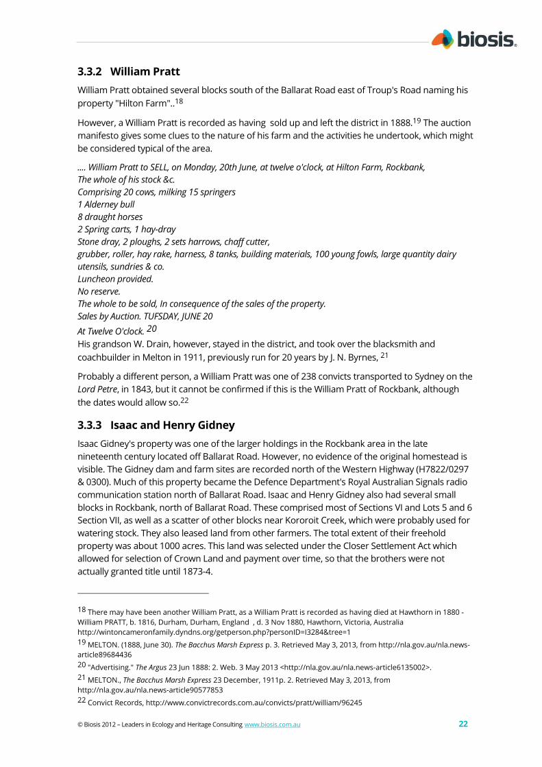


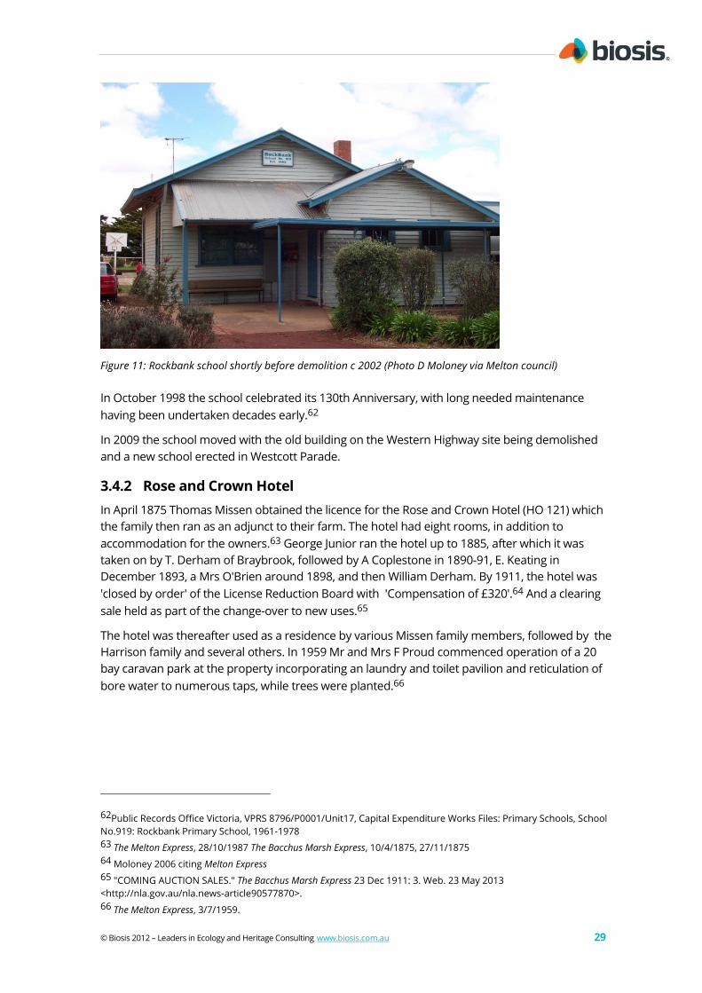


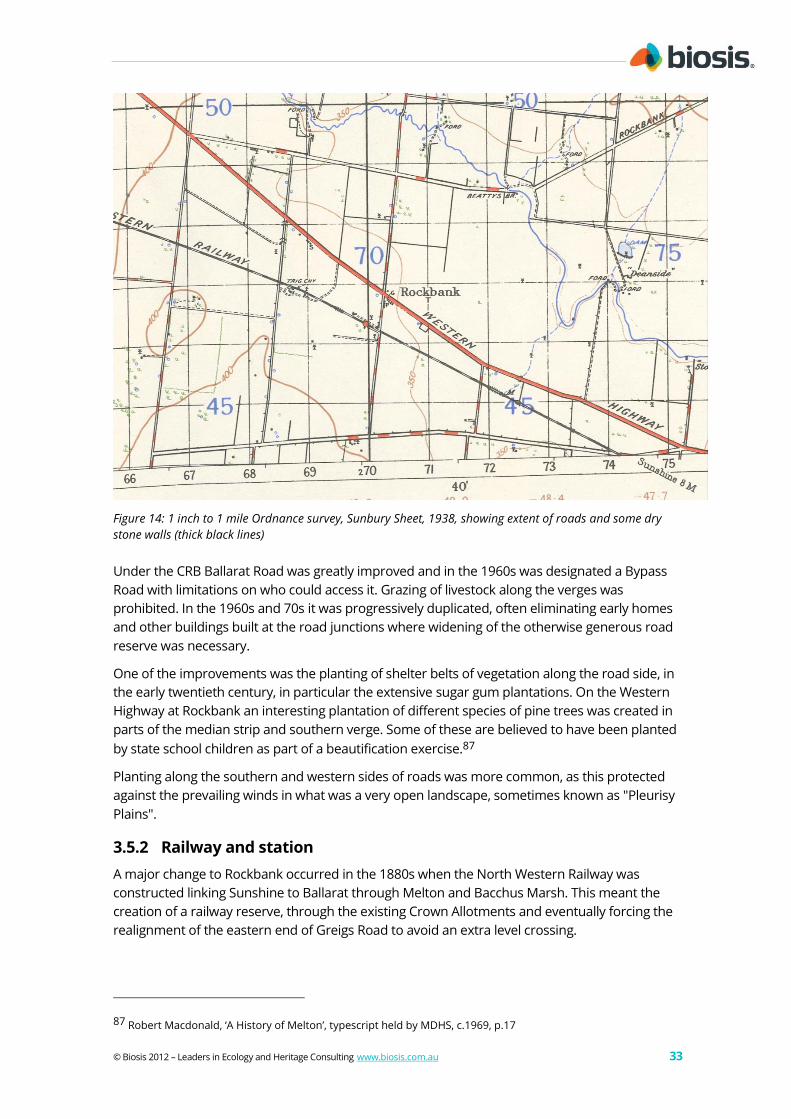


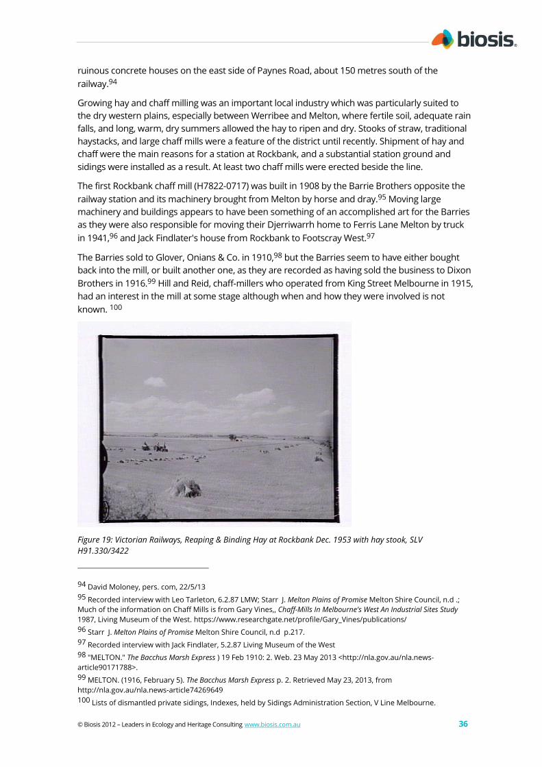


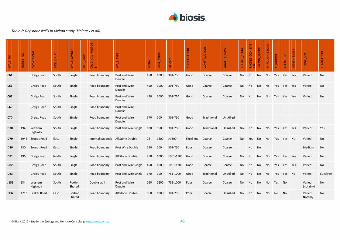


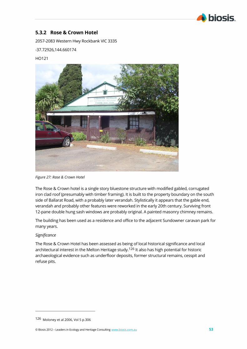


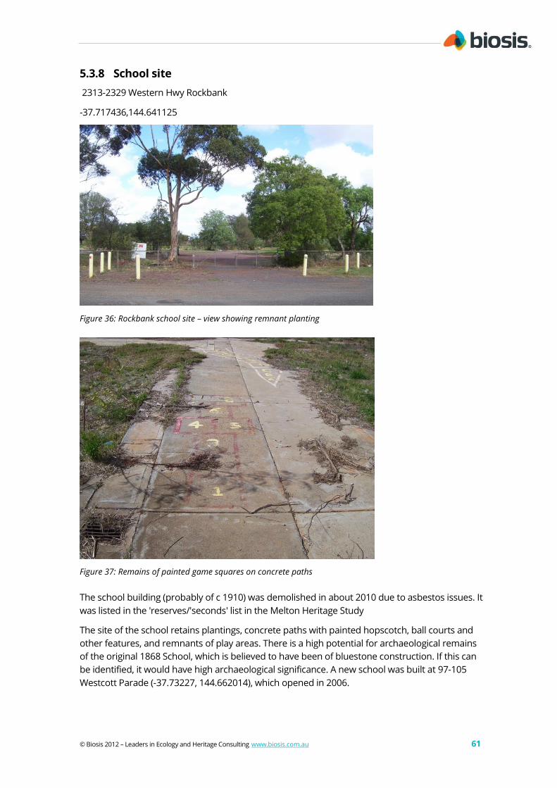
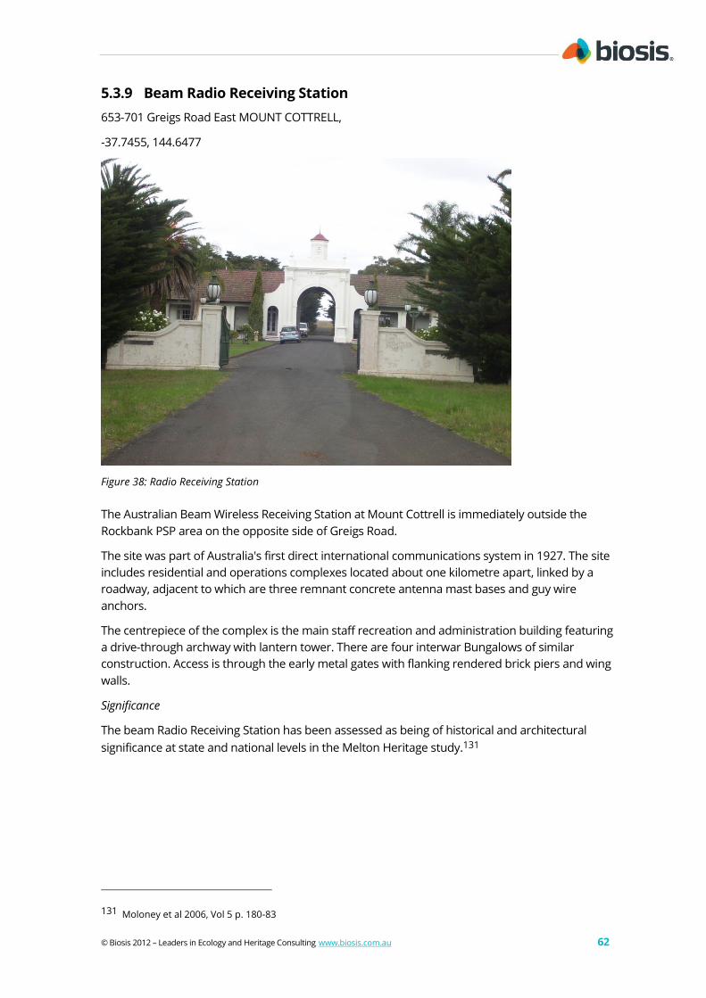
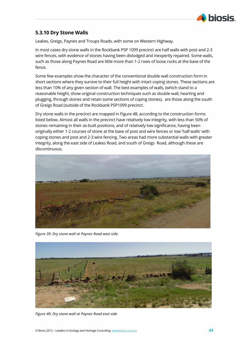


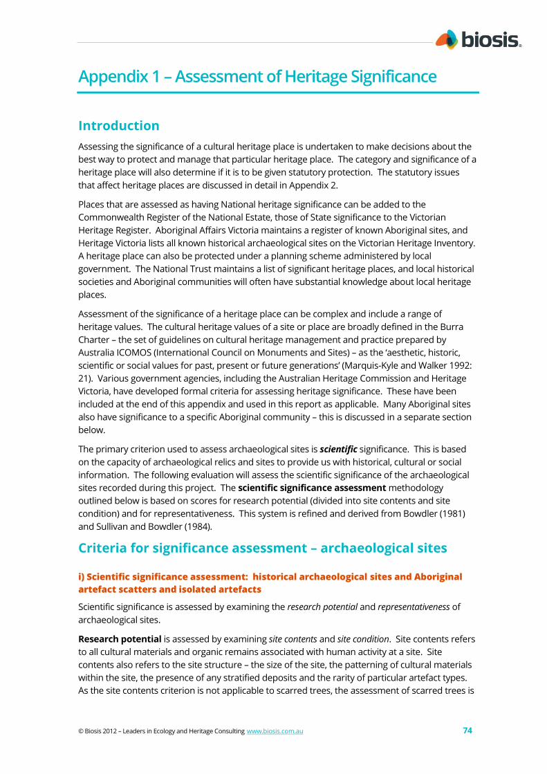


![WELCOME! [saas.convey.com]saas.convey.com/rs/sovos/images/2013.08.20-b-p-notice-webinar.pdf · Form Types Include: 1099-B 1099-Div 1099-Int 1099-Misc 1099-OID W-2G 1099-K CP2100 or](https://static.documents.pub/doc/80x56/5b93a81b09d3f2df3f8b4a61/welcome-saas-saas-form-types-include-1099-b-1099-div-1099-int-1099-misc.jpg)