41
safesystemsolutions.com.au Rosanna Road, Heidelberg Road Safety Assessment
safesystemsolutions.com.au
Rosanna Road, Heidelberg
Road Safety Assessment

Road Safety Assessment – Rosanna Road | 2
Information page
DATE: 07/03/2016
CLIENT: VicRoads Metro North West
ASSESSMENT NUMBER: SSS20160307KB.1
QUALITY RECORD:
Issue Date Description Prepared By Reviewed By Approved By
1 14/03/2016 Draft Report Jamie Robertson Kenn Beer
Safe System Solutions Pty Ltd
P 03 9381 2222 M 0401 345 461
Office G2, 10-14 Hope Street, Brunswick, Vic, 3056
www.SafeSystemSolutions.com.au
Principal: Kenn Beer Director: Dr Tom Beer
Road Safety Design Specialist: Jamie Robertson Road Engineering Safety Specialist: David Williamson
Senior Project Engineer: Bertrand Chan Tin Senior Project Engineer: Richard Clayton
Projects Engineer: Shafiul Haque Projects Engineer: Shoji Nakayama
Projects Engineer: Viseth Uch Road Safety Behavioral Specialist: Barry Scott
Associate: Johann Tay, Torsten Bergh (Sweden)
ACN: 164 341 084 ABN: 98 164 341 084 Industry Code: 99994

Road Safety Assessment – Rosanna Road | 3
1. Executive Summary
Safe System Solutions Pty Ltd has been engaged by VicRoads Metropolitan North West Region to undertake an independent road safety assessment of the existing conditions on Rosanna Road between Banksia Street in Heidelberg and Lower Plenty Road in Rosanna. A number of issues have been identified associated with the following areas that require further investigation and consideration:
a) Roadside Hazards
b) Safety Barriers
c) Road Geometry
d) Street Lighting
e) Public Transport
f) Unsignalised Intersections
These are detailed in Table 7.
A variety of options exist for improving the safety of Rosanna Road. Safe System Solutions Pty Ltd has
provided a series of recommendations for further consideration, including relocation and/or shielding of power
poles, tree removal, restricting movements into and out of minor roads, investigation of high profile barrier
kerb, speed limit reductions and signage and line marking.
These recommendations are detailed in Table 7.
Road Safety Assessment – Rosanna Road | 4
2. Table of contents 1. Executive Summary 3
2. Table of contents 4
3. List of Abbreviations 5
4. List of Tables 5
5. List of Figures 5
6. Assessment Process 6
a) Road Safety Assessment 6 b) The Safety Assessment Team 6 c) Site inspections and meetings 7 d) Assessment method 7 e) Risk assessment 7
7. Background and Scope of Assessment 9
Section 1: Yarra Street to Darebin Street 10 Section 2: Darebin Street to Station Road 12 Section 3: Station Road to Lower Plenty Road 14
8. Crash Analysis 16
9. General comments 18
9.1 Road reserve & cross section 18 9.2 Traffic volumes 19 9.3 Signalised intersections 20 9.4 Unsignalised intersections & property accesses 21 9.5 Heavy vehicles 21 9.6 Vulnerable road users 21
10. Assessment Findings and Recommendations 22
a) Roadside Hazards 22 b) Safety Barriers 24 c) Road Geometry 25 d) Street Lighting 26 e) Public Transport 27 f) Unsignalised Intersections 28
Section Recommendations 29
g) Section 1: Banksia Street to Darebin Street 29 h) Section 2: Darebin Street to Station Road 31 i) Section 3: Station Road to Lower Plenty Road 33
11. Conclusion 36

Road Safety Assessment – Rosanna Road | 5
3. List of Abbreviations
DCA Definition for Classifying Accidents
OI Other Injury
SCATS Sydney Coordinated Adaptive Traffic System
SI Serious Injury
4. List of Tables Table 1: Inspection and meetings Table 2: Likelihood of a crash (Austroads, 2009) Table 3: Likely consequence of a crash (Austroads, 2009) Table 4: Resulting level of risk (Austroads, 2009) Table 5: Urban arterial lane widths (Austroads) Table 6: Typical mid-block capacities for urban roads with interrupted flow (Austroads) Table 7: Assessment Findings
5. List of Figures Figure 1: Map of Assessment Location
Figure 2: Rosanna Road Section 1
Figure 3: Facing north along Rosanna Road from Yarra Street
Figure 4: Facing north along Rosanna Road from south of Villa Street
Figure 5: Rosanna Road Section 2
Figure 6: Rosanna Road Section 2 - photo
Figure 7: Rosanna Road Section 3
Figure 8: Rosanna Road Section 3 at Lane Avenue
Figure 9: Rosanna Road Section 3 at Jones Cres
Figure 10: All crashes - Heat Map
Figure 11: Serious Injury - Heat Map
Figure 12: Rosanna Road at Darebin Street, PM Peak, Northbound

Road Safety Assessment – Rosanna Road | 6
6. Assessment Process
a) Road Safety Assessment
A road safety assessment is a review of an existing road or road related area with the objective of assessing the
road safety performance of the area. A road safety assessment is undertaken by an independent team with
expertise in road safety, engineering and traffic management.
b) The Safety Assessment Team
The Safety Assessment Team consisted of:
Kenn Beer (BEng (Hons), MPIA)
Principal
Senior Road Safety Auditor
Safe System Solutions Pty Ltd
Jamie Robertson (BEng (Hons), BSc)
Road Safety Design Specialist
Senior Road Safety Auditor
Safe System Solutions Pty Ltd
Luke Britnell (BEng)
Road Safety Engineering Specialist
Road Safety Auditor Safe System Solutions Pty Ltd

Road Safety Assessment – Rosanna Road | 7
c) Site inspections and meetings
A list of site inspections and meetings associated with this Road Safety Assessment is provided in the table below:
Table 1: Inspection and meetings
Activity Location Date Time
PRE-REVIEW MEETING VicRoads Sunshine 15/02/2016 1230
DAYTIME SITE INSPECTION Rosanna Road 29/02/2016 1000 - 1500
AFTERNOON PEAK INSPECTION Rosanna Road 08/03/2016 1700 – 1730
MORNING PEAK INSPECTION Rosanna Road 09/03/2016 0815 – 0845
FINAL INSPECTION Rosanna Road 10/03/2016 1630 - 1730
d) Assessment method
A review of the site has been completed and the details contained within any supporting documentation
examined to identify issues that affect road user safety and other relevant issues. The assessors cannot
guarantee that every issue that affects road user safety has been identified. Although the adoption of the
assessment recommendations will improve the level of safety of the site it will not, however, eliminate all the
road user safety risks.
e) Risk assessment
The potential road safety problems identified have been ranked as follows:
A risk rating has been determined based on the likelihood of a crash occurring as a result of the deficiency together with the potential consequence of that crash.
The risk ratings adopted are:
Intolerable
High
Medium
Low
Tables 2 to 4 below show the risk rating process.

Road Safety Assessment – Rosanna Road | 8
Table 2: Likelihood of a crash (Austroads, 2009)
Frequency Description
Frequent Once or more per week
Probable Once or more per year (but less than once a week)
Occasional Once every five to ten years
Improbable Less often than once every ten years
Table 3: Likely consequence of a crash (Austroads, 2009)
Consequence Description Examples
Catastrophic Likely multiple deaths
- High speed, multi-vehicle crash on a freeway - Car runs into crowded bus stop - Bus and petrol tanker collide - Collapse of a bridge or tunnel
Serious Likely deaths or serious injury
- High or medium speed vehicle/vehicle collision - High or medium speed collision with a fixed
roadside object - Pedestrian or cyclists struck by a car
Minor Likely minor injury - Some low speed vehicle collisions - Cyclist falls from bicycle at low speed - Left-turn rear-end crash in a slip lane
Limited Likely trivial injury or property damage only
- Some low speed vehicle collisions - Pedestrian walks into object (no head injury) - Car reverses into post
Table 4: Resulting level of risk (Austroads, 2009)
Frequent Probable Occasional Improbable
Catastrophic Intolerable Intolerable Intolerable High
Serious Intolerable Intolerable High Medium
Minor Intolerable High Medium Low
Limited High Medium Low Low

Road Safety Assessment – Rosanna Road | 9
7. Background and Scope of Assessment Rosanna Road (State Route 44) is a major urban arterial road carrying volumes of ~38,000 vehicles per day, with
1800 or 4.7% commercial vehicles. Rosanna Road provides a link between the Metropolitan Ring Road (M80) and
the Eastern Freeway (M3).
Rosanna Road consists of two traffic lanes in each direction with clearways operating between 6.30am to 9.30am
Monday to Friday for southbound traffic and 3.30pm to 6.30pm Monday to Friday for northbound traffic. A
60km/h speed limit applies along the entire length.
The land use along Rosanna Road is predominately residential on both sides with the Warringal Shopping Centre
and local retail shops on the western side between Darebin Street and Banksia Street, and Heidelberg Park on
the eastern side between Brown Street and Burgundy Street.
As part of the North East Truck Curfew Trial, between 10pm and 6am, trucks over 4.5 tonnes gross weight are
restricted from using Rosanna Road. This does not include vehicles such as buses, caravans, cranes, local service
vehicles and concrete pumps. The trial started in August 2015 and will continue to September 2016.
This Assessment has been made of the existing conditions of Rosanna Road. This is not a strategic transport
planning assessment of Rosanna Road and the surrounding transport network. As such, the Assessors have not
commented on the function of the road or the surrounding roads. Rather, the Assessors have made commentary
about the safety of the existing conditions of Rosanna Road and made recommendations on what could be done
on Rosanna Road to improve road safety, not on surrounding roads.
Figure 1: Map of Assessment Location
Road Safety Assessment – Rosanna Road | 10
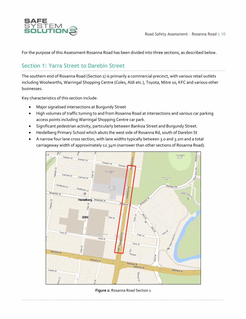
For the purpose of this Assessment Rosanna Road has been divided into three sections, as described below.
Section 1: Yarra Street to Darebin Street
The southern end of Rosanna Road (Section 1) is primarily a commercial precinct, with various retail outlets
including Woolworths, Warringal Shopping Centre (Coles, Aldi etc.), Toyota, Mitre 10, KFC and various other
businesses.
Key characteristics of this section include:
Major signalised intersections at Burgundy Street
High volumes of traffic turning to and from Rosanna Road at intersections and various car parking
access points including Warringal Shopping Centre car park.
Significant pedestrian activity, particularly between Banksia Street and Burgundy Street.
Heidelberg Primary School which abuts the west side of Rosanna Rd, south of Darebin St
A narrow four lane cross section, with lane widths typically between 3.0 and 3.2m and a total
carriageway width of approximately 12.34m (narrower than other sections of Rosanna Road).
Figure 2: Rosanna Road Section 1

Road Safety Assessment – Rosanna Road | 11
Figure 3: Facing north along Rosanna Road from Yarra Street
Figure 4: Facing north along Rosanna Road from south of Villa Street
Road Safety Assessment – Rosanna Road | 12
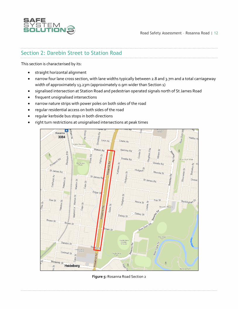
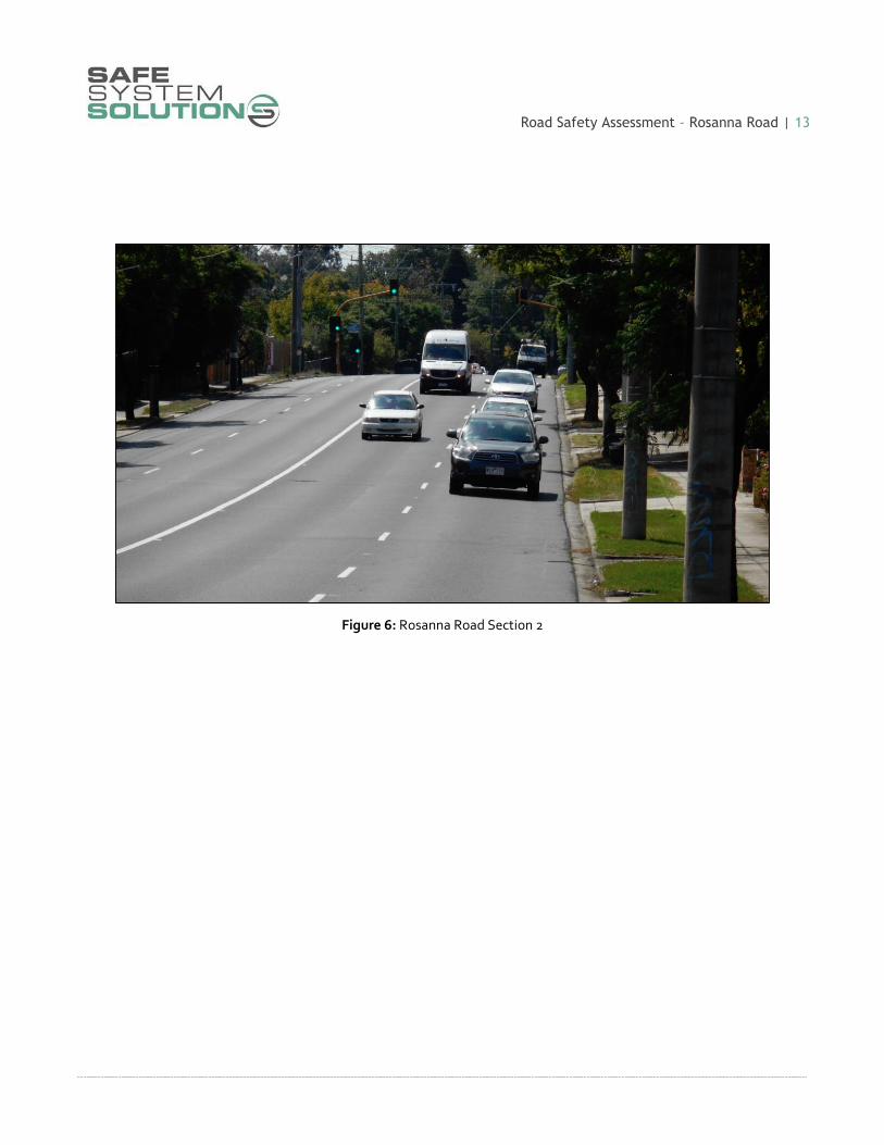
Section 2: Darebin Street to Station Road
This section is characterised by its:
straight horizontal alignment
narrow four lane cross section, with lane widths typically between 2.8 and 3.7m and a total carriageway
width of approximately 13.23m (approximately 0.9m wider than Section 1)
signalised intersection at Station Road and pedestrian operated signals north of St James Road
frequent unsignalised intersections
narrow nature strips with power poles on both sides of the road
regular residential access on both sides of the road
regular kerbside bus stops in both directions
right turn restrictions at unsignalised intersections at peak times
Figure 5: Rosanna Road Section 2
Road Safety Assessment – Rosanna Road | 13
Figure 6: Rosanna Road Section 2

Road Safety Assessment – Rosanna Road | 14
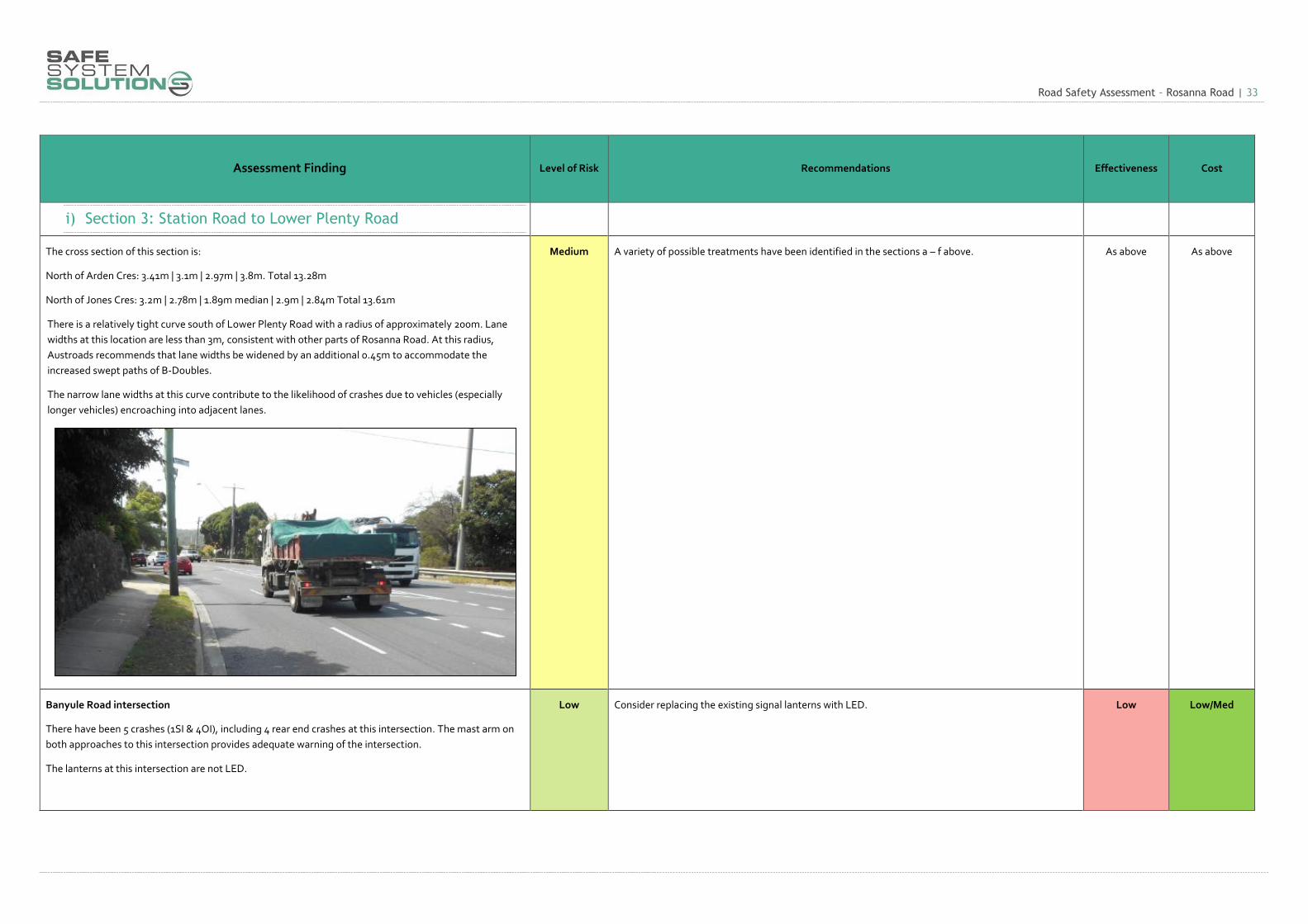
Section 3: Station Road to Lower Plenty Road
This section is characterised by its:
curvilinear horizontal alignment
undulating vertical alignment
narrow four lane cross section, with lane widths typically between 2.8 and 3.8m and a total carriageway
width of 13.2 to 13.6m (comparable to Section 2)
major signalised intersection at Lower Plenty Road and minor signalised intersection at Banyule Road
frequent unsignalised intersections
narrow nature strips with power poles on both sides of the road
regular residential access on both sides of the road
regular kerbside bus stops in both directions
right turn restrictions at unsignalised intersections at peak times
Figure 7: Rosanna Road Section 3

Road Safety Assessment – Rosanna Road | 15
Figure 8: Rosanna Road Section 3 at Lane Avenue
Figure 9: Rosanna Road Section 3 at Jones Cres

Road Safety Assessment – Rosanna Road | 16
8. Crash Analysis
In the 5 year period to the end of June 2015 there were 75 casualty crashes on the section of Rosanna Road from Yarra Street to Lower Heidelberg Road inclusive, including 15 serious injury crashes and 60 other injury crashes. The heat maps below illustrate the locations of crashes on Rosanna Road and adjacent roads.
Figure 10: All crashes - Heat Map Figure 11: Serious Injury - Heat Map

Road Safety Assessment – Rosanna Road | 17
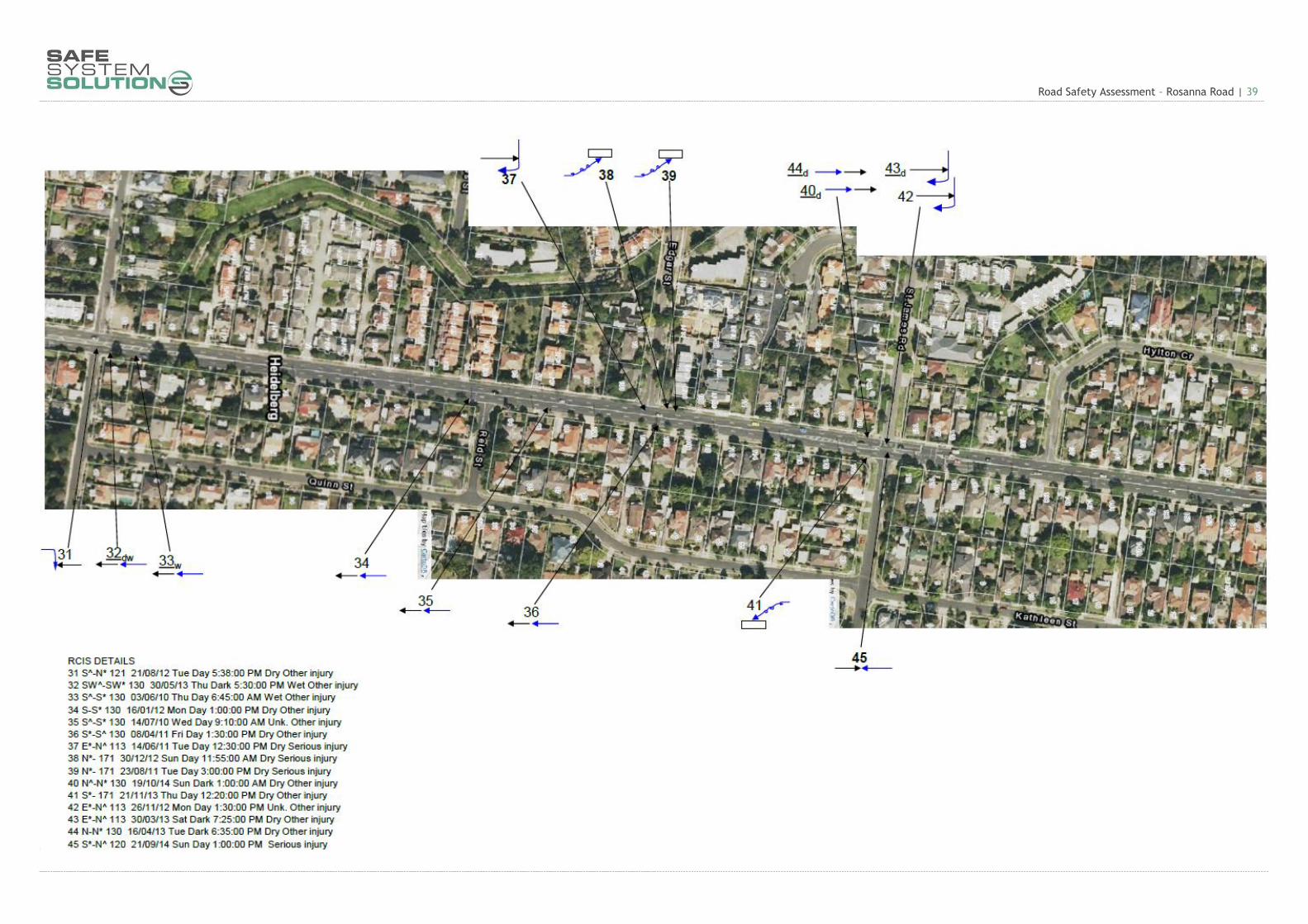
Crash data is summarised in crash diagrams included in Appendix A.
These diagrams show that most crashes are occurring at intersections along Rosanna Road, with the worst locations being the intersections of Rosanna Road and:
1. Lower Plenty Road: 15 crashes
2. Burgundy Street: 9 crashes
3. St James Road: 6 crashes
4. Yarra Street: 6 crashes
5. Darebin Street: 5 crashes
6. Banyule Road: 5 crashes
A number of clear crash trends are also evident, including:
Rear end (DCA 130) and right turn against (DCA 121) crashes at signalised intersections
Cross traffic crashes (DCA 110) at unsignalised intersections
Rear end crashes and other crashes involving vehicles travelling in the same direction at mid-block locations on Rosanna Road
A significant number of crashes (26) occurred in dark or dusk conditions. Of particular concern is the number of crashes that have occurred at Lower Plenty Road (10 out of 15) and in the vicinity of Burgundy Street (5 out of 9) in poor light.
Road Safety Assessment – Rosanna Road | 18
9. General comments
9.1 Road reserve & cross section
The Rosanna Road road reserve is approximately 20m wide, which generally provides for a footpath and nature strip on both sides and two traffic lanes in each direction.
Existing traffic lane widths range from approximately 2.6m to 3.8m and are generally in the range of 2.8m to 3.2m.
Minor, localised widening has occurred to accommodate 5-lane treatments (i.e. with central right turn lanes) at a number of intersections. At these locations traffic lanes are typically in the order of 2.8m wide.
Austroads recommends that the ‘standard’ traffic lane width of 3.5m be generally adopted in urban areas and provides the table below as guidance for practitioners.
Table 5: Urban arterial lane widths (Austroads)
It is noted that it is common practice to adopt lesser lane widths than those prescribed above, particularly at intersections. Regardless, the existing traffic lanes on Rosanna Road are particularly narrow at some locations which is likely to contribute to some types of vehicle conflicts.

Road Safety Assessment – Rosanna Road | 19
9.2 Traffic volumes
Rosanna Road currently carries approximately 38,000 vehicles per day. Site observations and anecdotal
evidence suggest that Rosanna Road is currently operating at or near its capacity.
The overall capacity of Rosanna Road is largely determined by the major signalised intersections at Banksia
Street, Burgundy Street and Lower Plenty Road. Other factors which limit the capacity of Rosanna Road may
include:
Influence of parked vehicles
Traffic turning at unsignalised intersections
Coordination of traffic signals along Rosanna Road and intersecting routes
Information obtained from SCATS indicates that approximately 800 vehicles per hour per lane currently travel
in the peak direction (i.e. southbound in the AM peak and northbound in the PM peak).
Figure 12: Rosanna Road at Darebin Street, PM Peak, Northbound
Road Safety Assessment – Rosanna Road | 20
Table 6: Typical mid-block capacities for urban roads with interrupted flow (Austroads)
As the traffic volumes on Rosanna Road are approaching capacity, and are expected to continue to grow,
Austroads notes that peak period mid-block traffic volumes may increase to 1200 to 1400 pc/h/ln on any
approach road when the following conditions exist or can be implemented:
adequate flaring at major upstream intersections
uninterrupted flow from a wider carriageway upstream of an intersection approach and flowing at
capacity
control or absence of crossing or entering traffic at minor intersections by major road priority controls
control or absence of parking
control or absence of right turns by banning turning at difficult intersections
high volume flows of traffic from upstream intersections during more than one phase of a signal cycle
good co-ordination of traffic signals along the route.
9.3 Signalised intersections
As indicated in Section 8 of this report, the highest number of crashes occur at signalised intersections. While signalising intersections improves the safety, it does not eliminate the possibility of crashes occurring. Additional features at signalised intersections may improve their safety performance, including fully controlled right turns (red arrows), signal mast arms and red light cameras.

Road Safety Assessment – Rosanna Road | 21
9.4 Unsignalised intersections & property accesses
A significant proportion of crashes along Rosanna Road occur at unsignalised intersections and property access points. Due to the high traffic volumes on Rosanna Road, motorists can have difficulty choosing an appropriate gap in traffic whilst turning into or out of side streets or driveways. Right turn bans are currently in place at a number of locations, including:
Douglas Street, Brown Street – full time ban for southbound traffic
Laane Avenue – PM peak ban for northbound traffic
Leon Avenue, St James Road & Edgar Street – AM peak ban for southbound traffic
All other turning movements are permitted at these intersections.
9.5 Heavy vehicles
Rosanna Road is gazetted for use by B-Doubles. The maximum width of a B-Double is 2.5m (not including mirrors). Some isolated locations of Rosanna Road have lane widths of only 2.6m. 6 crashes in the last 5 years involved heavy vehicles.
9.6 Vulnerable road users
Pedestrian activity is concentrated at:
The commercial precinct extending from Banksia Street to Darebin Street (including the Heidelberg
Primary School)
The traffic signals at Lower Plenty Road, Banyule Road, Station Road and north of St James Road
Rosanna Road is not part of the Principal Bicycle Network and is not a Bicycle Priority Route. No bicycle facilities currently exist and very few cyclists were observed using Rosanna Road. In the last 5 years, crashes involving vulnerable road users included:
4 crashes involving a pedestrian
3 crashes involving a cyclist
6 crashes involving a motorcyclist

10. Assessment Findings and Recommendations The findings and recommendations of the Road Safety Assessment can be found in Table 7 below.
Costs Legend: Low: $0 - $50K Low/Med: $50K – $200K Med: $200K - $500K Med/High: $500K - $1M High: $1M - $50M Very High $50M+
Table 7: Assessment Findings
Assessment Finding Level of Risk Recommendations Effectiveness Cost
a) Roadside Hazards
The foremost roadside hazards are the power poles that extend along both sides of Rosanna Road for
most of the subject length.
Some are located near the property boundary however most are located within the narrow nature strip
between the footpath and the roadway. In some cases poles are located very close to the back of kerb.
Collectively, these poles represent a significant risk to errant motorists. Those poles located closest to the
roadway, near intersections or on the outside of curves are at greater risk of being struck.
Some poles close to the road appear to be within the
‘working width’ for high vehicles and at risk of being
struck by tilting trucks (see diagram).
There is also potential for poles near intersections to be
struck by turning vehicles (particularly longer vehicles).
In some cases the power poles may impede sight lines
to approaching traffic.
High Where feasible, consider relocating power poles
to property boundaries.
Note however that this is likely to adversely
affect pedestrian movements along footpaths.
There may also be major underground services
that require relocation as part of this
recommendation.
There are significant costs associated with
moving power poles.
Medium High
Consider removing power poles and undergrounding power lines.
This solution would provide the best safety outcome however it is acknowledged that it may be
difficult to achieve given the restricted width available and potential clearance issues with other
services.
High Very High
Consider shielding power poles with safety barriers. Options
include:
Guard fence
Concrete barriers (see section b below)
Raptor crash cushions (pictured)
It is noted that in many cases there is inadequate width between
the edge of road and poles to accommodate safety barriers or to
accommodate barrier deflection.
Medium Medium

Road Safety Assessment – Rosanna Road | 23
Assessment Finding Level of Risk Recommendations Effectiveness Cost
… continued
Investigate the use of high profile barrier kerb1 along the outer kerb on both sides of Rosanna Road
between Darebin Street and Lower Plenty Road.
It should be noted that additional measures may be required to ensure pedestrian safety is
maintained.
Medium Med/High
Consider removing isolated trees close to intersections that restrict sight distances.
It should also be noted that other trees along the nature strips pose a hazard to a motorist that leaves
the road. Their removal will reduce the risk of injury due to run-off-road crashes.
As with the removal of any vegetation, consideration of the externality value should be undertaken.
Low Low
1 https://www.vicroads.vic.gov.au/~/media/files/technicaldocuments/standards-and-supplements/roaddesignnote0301useofhighprofilebarrierkerbhpbk.ashx
Road Safety Assessment – Rosanna Road | 24
Assessment Finding Level of Risk Recommendations Effectiveness Cost
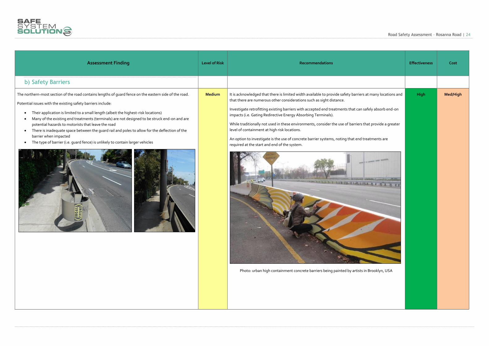
b) Safety Barriers
The northern-most section of the road contains lengths of guard fence on the eastern side of the road.
Potential issues with the existing safety barriers include:
Their application is limited to a small length (albeit the highest-risk locations)
Many of the existing end treatments (terminals) are not designed to be struck end-on and are
potential hazards to motorists that leave the road
There is inadequate space between the guard rail and poles to allow for the deflection of the
barrier when impacted
The type of barrier (i.e. guard fence) is unlikely to contain larger vehicles
Medium It is acknowledged that there is limited width available to provide safety barriers at many locations and
that there are numerous other considerations such as sight distance.
Investigate retrofitting existing barriers with accepted end treatments that can safely absorb end-on
impacts (i.e. Gating Redirective Energy Absorbing Terminals).
While traditionally not used in these environments, consider the use of barriers that provide a greater
level of containment at high risk locations.
An option to investigate is the use of concrete barrier systems, noting that end treatments are
required at the start and end of the system.
Photo: urban high containment concrete barriers being painted by artists in Brooklyn, USA
High Med/High

Road Safety Assessment – Rosanna Road | 25
Assessment Finding Level of Risk Recommendations Effectiveness Cost
c) Road Geometry
The existing lane widths and carriageway widths are less than desirable.
Refer section 9.1 above.
Heavy vehicles were observed to occupy almost the entire traffic lane. This caused other vehicles to move
into less desirable locations.
Low Investigate widening the lanes where possible. It is acknowledged that there are significant width
constraints.
Medium High
If widening the road is not feasible, consider reducing the speed limit. Medium Low
A high number of rear end casualty crashes have been recorded on Rosanna Road, most in the vicinity of
intersections. Presumably many more crashes of this type have occurred that have only resulted in
property damage, and thus do not appear in the crash statistics.
Downhill grades and limited sight distance due to the horizontal and vertical alignment of the road are
likely contributing factors.
Medium Consider measures to reduce the incidence of rear end crashes, including:
Reducing the speed limit
Providing high skid resistant pavement (eg. calcine bauxite) at high risk locations such as
downhill approaches to intersections
Installing devices that provide advance warning of intersections
Medium Low/Med

Road Safety Assessment – Rosanna Road | 26
Assessment Finding Level of Risk Recommendations Effectiveness Cost
d) Street Lighting
A significant proportion of crashes within the subject area occurred during poor light conditions.
Inadequate street lighting may have been a contributing factor in these crashes. Night time crashes are
particularly prevalent at the intersections at Lower Plenty Road and Burgundy Road.
It is noted that the majority of street lights along Rosanna Road are mounted on power distribution poles.
At many locations, the presence of overhead power lines precludes the use of dedicated (and frangible)
lighting poles and is quite restrictive in terms of the way the route is lit.
There are also a number of rigid lighting poles within the project area which are hazards to errant
motorists.
Low Undertake a street lighting assessment to determine the adequacy of the existing lighting.
Consider upgrading lighting to meet current standards where necessary.
Consider replacing rigid lighting poles with frangible types where possible.
Medium Med/High

Road Safety Assessment – Rosanna Road | 27
Assessment Finding Level of Risk Recommendations Effectiveness Cost
e) Public Transport
Kerbside bus stops are in place on both sides of Rosanna Road. The buses frequently stop which can cause
other motrists to attempt to change lanes at undesirable times.
2 crashes in the last five years involved buses.
Low Consider the installation of yellow box line-marking for all bus stop locations.
It should be noted that many of the other recommendations throughout this report will improve the
safety of buses and/or vehicles around buses.
Low Low

Road Safety Assessment – Rosanna Road | 28
Assessment Finding Level of Risk Recommendations Effectiveness Cost
f) Unsignalised Intersections
The vast majority of crashes at unsignalised intersections along Rosanna Road involve vehicles from
adjacent directions (often right turn against type crashes) or vehicles travelling in the same direction (rear
end crashes or similar).
Many of these are associated with vehicles turning right into side streets that do not have auxiliary right
turn lanes. Right turn bans are in place at some of these intersections but not others. Vehicles waiting to
turn right are at increased risk of rear end collisions and also cause disruption to traffic which may have
other negative safety impacts.
Other crashes involve vehicles turning out of side streets, particularly to the right.
Trees, power poles and other roadside objects impede sight lines from side roads at a number of
locations.
High Consider implementing additional right turn bans at unsignalised intersections without right turn
lanes.
Consider implementing left-in left-out restrictions at minor intersections.
Consider truncating minor streets, such as at Berrima Road.
Consider upgrading some of the no right turn signs to electronic signs.
As per finding a) consider trimming or removing trees to improve sight lines from side roads.
Medium Low
High Low/Med
High Low/Med
Medium Low/Med
Low Low

Road Safety Assessment – Rosanna Road | 29
Assessment Finding Level of Risk Recommendations Effectiveness Cost
Section Recommendations g) Section 1: Banksia Street to Darebin Street
There is a high concentration of crashes within this section (26 in approx. 550m). This is primarily
attributed to the high volumes of turning traffic and congestion associated with the intersections and
commercial access points within this section.
2 out of 4 pedestrian crashes occurred within this section.
Significant pedestrian movement occurs within this section, particularly between Banksia Street and
Burgundy Street. Heidelberg Primary School, which abuts the west side of Rosanna Road, south of
Darebin Street, also generates
This section has a narrow cross section for a four lane road (and narrower than other sections of Rosanna
Road), with lane widths typically between 3.0 and 3.2m and a total carriageway width of approximately
12.34m.
Medium Consider a reduction in the posted speed limit within this section for the reasons outlined.
Consideration could be given to the installation of a 40km/h strip shopping centre linking into a remote
school speed zone.
High/Med Low/Med
Yarra Street intersection
There were 6 crashes (2SI and 4OI), at this intersection, including 4 cross traffic crashes. There is a trend of
cross traffic crashes involving vehicles exiting Yarra Street and colliding with through traffic on Rosanna
Road on both approaches.
The Assessors viewed this intersection at many different times of the day and believe this intersection
poses a high risk for motorists.
It should be noted that the keep clear line-marking at this location are faded.
High Consider restricting movements at this location to reduce conflict points.
(as an immediate treatment, refresh the ‘keep clear’ markings)
High Low/Med
Road Safety Assessment – Rosanna Road | 30
Assessment Finding Level of Risk Recommendations Effectiveness Cost
Villa Street intersection
There have been 3 crashes (3OI) at this intersection over the last five years. There is no clear pattern of
these crashes
Like the Yarra Street intersection, the high number of conflict points and high cognitive load on a driver
makes exiting or entering this street challenging. As it is only a T-intersection the risk is less than that of
Yarra Street.
Medium Consider restricting the turning movements at this intersection.
(Note: the proposed speed limit reduction on Rosanna Road at this location will improve safety)
Med/High Med/Low
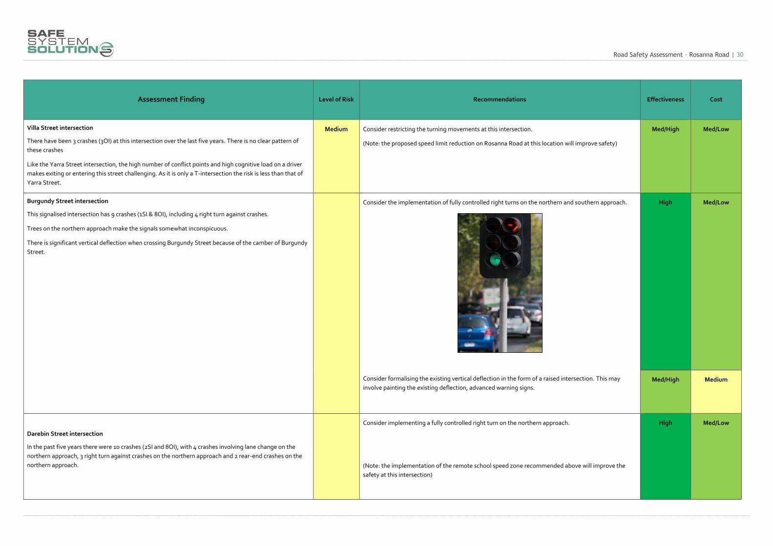
Burgundy Street intersection
This signalised intersection has 9 crashes (1SI & 8OI), including 4 right turn against crashes.
Trees on the northern approach make the signals somewhat inconspicuous.
There is significant vertical deflection when crossing Burgundy Street because of the camber of Burgundy
Street.
Consider the implementation of fully controlled right turns on the northern and southern approach.
Consider formalising the existing vertical deflection in the form of a raised intersection. This may
involve painting the existing deflection, advanced warning signs.
High
Med/Low
Med/High Medium
Darebin Street intersection
In the past five years there were 10 crashes (2SI and 8OI), with 4 crashes involving lane change on the
northern approach, 3 right turn against crashes on the northern approach and 2 rear-end crashes on the
northern approach.
Consider implementing a fully controlled right turn on the northern approach.
(Note: the implementation of the remote school speed zone recommended above will improve the
safety at this intersection)
High Med/Low

Road Safety Assessment – Rosanna Road | 31
Assessment Finding Level of Risk Recommendations Effectiveness Cost
h) Section 2: Darebin Street to Station Road
This section is characterised by the straight horizontal alignment, four lane cross section, narrow nature
strips with power poles on both sides of the road, and regular residential access on both sides of the road.
There are right turn restrictions during peak hours at unsignalised intersections.
Sight distance is restricted at some intersections due to trees and power poles.
The continuous length of power poles reduces conspicuity of side roads.
There are regular bus stops within the left lane in both directions.
The cross section south of Reid Street: 3.7m | 3.02m | 2.81m | 3.7m. Total 13.23m
Medium As identified in the general section above, consider:
Electronic flashing no right turn signs at unsignalised intersections (given that these are only
triggered during peak periods).
Improving intersection sight distance through three removal
Restricting turning movements where possible
As above As above
St James Road intersection
At this intersection there were 6 crashes (1SI and 5 OI), with 2 rear end crashes and 2 right out crashes.
There are some sight distance issues at this intersection due to the poles from the signals and power poles
from the eastern approach.
Medium Consider the relocation of the pedestrian operated signsals (pictured left) to the intersection and
creating a fully signalised intersection.
Med/High High
Road Safety Assessment – Rosanna Road | 32
Assessment Finding Level of Risk Recommendations Effectiveness Cost
Station Road intersection
The Station Road intersection is preforming better than many of the other intersection on Rosanna Road.
It has one other injury crash on the approach and one near the intersection.
Low General treatments above will improve the safety of this intersection. As above As above
Unsignalised intersections
Brown St: 3 crashes (3OI), 2 rear end and 1 right turn against.
Edgar St: 4 crashes (3SI and 1OI), 2 being run off road crashes into power poles.
High As identified in the general section above, consider:
Electronic flashing no right turn signs at unsignalised intersections (given that these are only triggered
during peak periods).
Improve intersection sight distance through three removal
Restrict movements where possible
As above As above
Road Safety Assessment – Rosanna Road | 33
Assessment Finding Level of Risk Recommendations Effectiveness Cost
i) Section 3: Station Road to Lower Plenty Road
The cross section of this section is:
North of Arden Cres: 3.41m | 3.1m | 2.97m | 3.8m. Total 13.28m
North of Jones Cres: 3.2m | 2.78m | 1.89m median | 2.9m | 2.84m Total 13.61m
There is a relatively tight curve south of Lower Plenty Road with a radius of approximately 200m. Lane
widths at this location are less than 3m, consistent with other parts of Rosanna Road. At this radius,
Austroads recommends that lane widths be widened by an additional 0.45m to accommodate the
increased swept paths of B-Doubles.
The narrow lane widths at this curve contribute to the likelihood of crashes due to vehicles (especially
longer vehicles) encroaching into adjacent lanes.
Medium A variety of possible treatments have been identified in the sections a – f above.
As above As above
Banyule Road intersection
There have been 5 crashes (1SI & 4OI), including 4 rear end crashes at this intersection. The mast arm on
both approaches to this intersection provides adequate warning of the intersection.
The lanterns at this intersection are not LED.
Low Consider replacing the existing signal lanterns with LED. Low Low/Med

Road Safety Assessment – Rosanna Road | 34
Assessment Finding Level of Risk Recommendations Effectiveness Cost
Lower Plenty Road intersection
The intersection of Lower Plenty Road and Rosanna Road is not a conventional T-intersection. Rosanna
Road intersects at a low angle. Because of the geometry, vehicles entering Lower Plenty Road must
navigate the superelevation of this irregular intersection.
In the last five years there have been 15 crashes (2SI and 13OI), with 14 involving vehicles from the
southern approach. 5 crashes involved vehicles running the red light from the southern approach and 6
crashes involved vehicles from the southern approach losing control once they have entered the
intersection.
The Assessors believe there are 2 main factors contributing to the crashes at this intersection:
1. The alignment of the intersection and the need for a majority of vehicles to make a turn (in both
directions). Vehicles taking the right turn from the southern approach at high speed would most
likely be the cause of the run off road crashes.
2. The conspicuity of the intersection from the southern approach. The curves on the approach to
the intersection reduce sight lines to the intersection, and furthermore there is no mast arm on
this approach. There is also limited warning signage as you approach the intersection (refer
sequence of photos below) and the speed advisory signage is located immediately at the
intersection.
High The Assessors recommend investigation of a variety of options for this intersection, including:
Installation of mast arms
Improve approach warning signage (could be electronic)
Dynamic speed warning signage (slow down, too fast)
Medium Low/Med
Low Low
Medium Low/Med

Road Safety Assessment – Rosanna Road | 35
Assessment Finding Level of Risk Recommendations Effectiveness Cost
The following sequence of signs is observed when approaching Lower Plenty Road from the south:
Curve warning sign with 35km/h advisory speed
List type advance direction sign
Intersection direction signs with SLOW TO 35km/h supplementary panels
Below: Lower Plenty Road showing evidence of loss of control crashes
Installation of a safety platform on the southern approach to reduce speeds to address all
crash types.
Installation of safety barrier on the northern departure to the intersection.
Modification of the alignment of the intersection to increase the entry angle.
High Medium
Medium Low/Med
High High

Road Safety Assessment – Rosanna Road | 36
11. Conclusion This Road Safety Assessment has been conducted in accordance with best practice road safety assessment
principles. The site has been inspected and the supporting documentation has been examined. The findings and
recommendations are provided for consideration by the client and any other interested parties.
Assessors:
14 / 03/ 2016
Kenn Beer (BEng, MPIA)
Senior Road Safety Auditor
Principal
Safe System Solutions Pty Ltd
14 / 03 / 2016
Jamie Robertson (BEng, BSc)
Senior Road Safety Auditor
Road Safety Design Specialist
Safe System Solutions Pty Ltd

Road Safety Assessment – Rosanna Road | 37
Appendix A: Crash Diagrams

Road Safety Assessment – Rosanna Road | 38
Road Safety Assessment – Rosanna Road | 39

Road Safety Assessment – Rosanna Road | 40

Road Safety Assessment – Rosanna Road | 41


