75
ROSEMARKIE CAVES PROJECT Archaeological Excavation in Learnie 1A/B, Learnie 2B/2C Near Rosemarkie, Ross-shire Data Structure Report 2017 Excavations
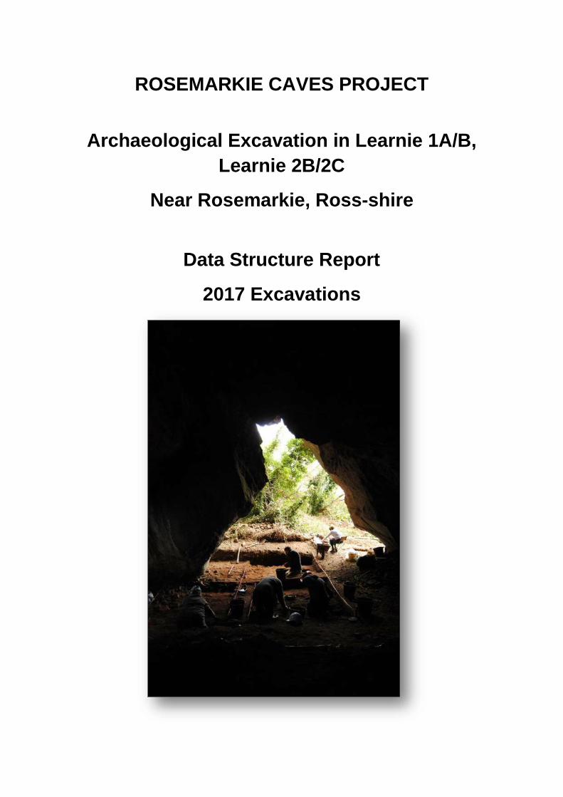
ROSEMARKIE CAVES PROJECT
Archaeological Excavation in Learnie 1A/B,
Learnie 2B/2C
Near Rosemarkie, Ross-shire
Data Structure Report
2017 Excavations
Rosemarkie Caves Project: Data Structure Report: 2017 Excavations in Learnie 1A/1B, 2A/2B
- 1 -
Rosemarkie Caves Project
Archaeological Excavation in Learnie 1A/B, Learnie 2B/2C
Near Rosemarkie, Ross-shire
Data Structure Report 2017 Excavations
National Grid Reference
NH 756 608 (centred)
Site Code
L1A17, L1B17, L2B17, L2C17
Date
31st January 2018
Authors
Birch, S. & Peteranna, M.
Illustrations
Peteranna, M. & Teufel, L.
Rosemarkie Caves Project: Data Structure Report: 2017 Excavations in Learnie 1A/1B, 2A/2B
- 2 -
Table of Contents
1 SUMMARY ................................................................................................................................. - 6 -
2 LOCATION AND GEOLOGY ......................................................................................................... - 6 -
3 ARCHAEOLOGICAL AND HISTORICAL BACKGROUND ................................................................ - 7 -
3.1 2010 Caird’s Cave Excavation ........................................................................................................ - 7 -
3.2 2011-2015 Test Pitting................................................................................................................... - 7 -
3.3 Excavation in Learnie 2B ................................................................................................................ - 8 -
4.0 AIMS AND OBJECTIVES ............................................................................................................ - 18 -
5.0 METHODOLOGY ....................................................................................................................... - 18 -
5.1 Permissions .................................................................................................................................. - 18 -
5.2 Learnie 1A and Learnie 1B ........................................................................................................... - 19 -
5.3 Learnie 2B and Learnie 2C ........................................................................................................... - 19 -
5.4 Excavation .................................................................................................................................... - 19 -
5.5 Sample and finds processing ....................................................................................................... - 19 -
6 RESULTS ................................................................................................................................... - 20 -
6.1 Learnie 1B .................................................................................................................................... - 20 -
6.2 Learnie 1A .................................................................................................................................... - 21 -
6.3 Learnie 2B .................................................................................................................................... - 22 -
6.4 Learnie 2C .................................................................................................................................... - 22 -
7 DISCUSSION ............................................................................................................................. - 23 -
7.1 Learnie 1A / 1B ............................................................................................................................ - 23 -
7.2 Learnie 2B .................................................................................................................................... - 24 -
8 CONCLUSION AND RECOMMENDATIONS ............................................................................... - 24 -
9 REFERENCES ............................................................................................................................. - 25 -
List of Tables
Table 1: Learnie 1B and Learnie 2B radiocarbon dates……………………………………………………………………………- 10 -
List of Figures
Figure 1: S- and W-facing sections of Test Pit 1 from Learnie 1B in 2013 (Peteranna and Gunn 2015) - 10 -
Figure 2: Location of the Learnie cave group, showing the Learnie groups of caves ............................. - 12 -
Figure 3: Location of the 2017 excavation trenches in Learnie 1B (top, showing the 2013 test pit site)
Learnie 1A (bottom) ..................................................................................................................................... - 14 -
Figure 4: Location of the 2017 excavation trenches in Learnie 2C (top) and Learnie 2B (bottom),
showing the 2016 extent of excavation………………………………………………………………………………………………….- 15 -

Rosemarkie Caves Project: Data Structure Report: 2017 Excavations in Learnie 1A/1B, 2A/2B
- 3 -
Figure 5: Mid-excavation plan of the excavation trench in Learnie 1B, showing hearths (117), (118) and
(119) on surface (116/103) (inset: plan/section of heart (117)) .................................................................. - 26 -
Figure 6: Mid-excavation plan of the excavation trench in Learnie 1B, showing hearths (126), (128) and
(130) and middens (125), (134) ................................................................................................................... - 27 -
Figure 7: Post-excavation plan of the excavation trench in Learnie 1B, showing the surface of (108) on
east side of trench and (142) on west side of trench; location of section drawings ................................... - 28 -
Figure 8: Learnie 1B section drawings: G-I, F-H and J-G and G-H, showing the sequence of archaeological
deposits across the cave .............................................................................................................................. - 29 -
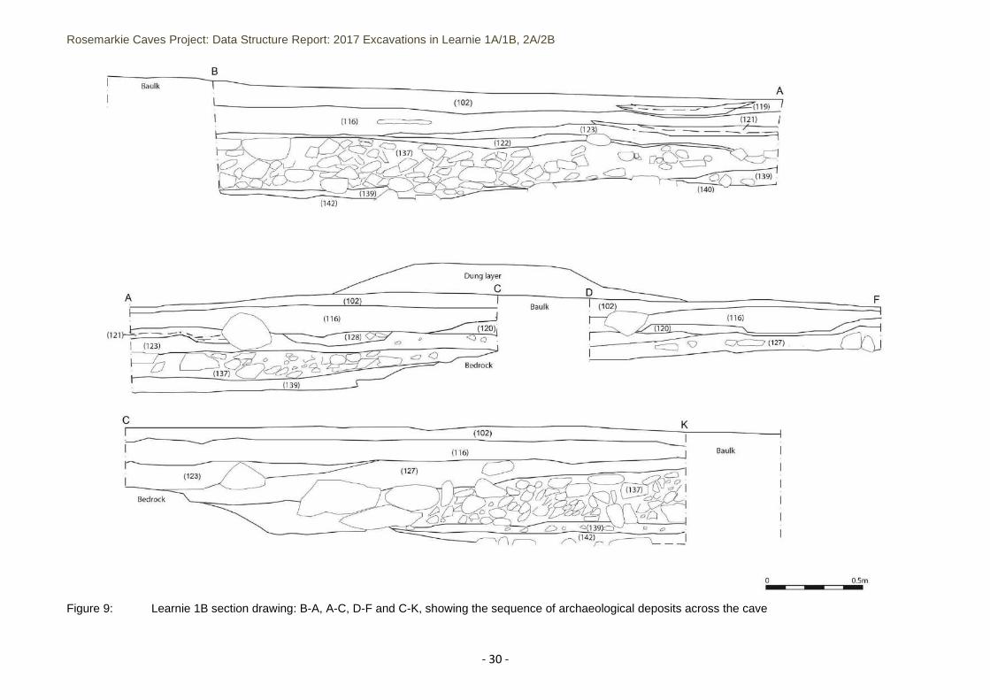
Figure 9: Learnie 1B section drawing: B-A, A-C, D-F and C-K, showing the sequence of archaeological
deposits across the cave .............................................................................................................................. - 30 -
Figure 10: Post-excavation plan of Learnie 1A, showing excavation to the possible wall (306) on the west
side and the base of the sub-trench to (310) in the east side of the trench ................................................ - 31 -
Figure 11: Learnie 1A: E-facing section of the central trench baulk, showing the deposits in the sub-trench
on the east half of the excavation area ....................................................................................................... - 32 -
Figure 12: Learnie 2B: S-facing section of trench 2 in the cave entrance ................................................ - 33 -
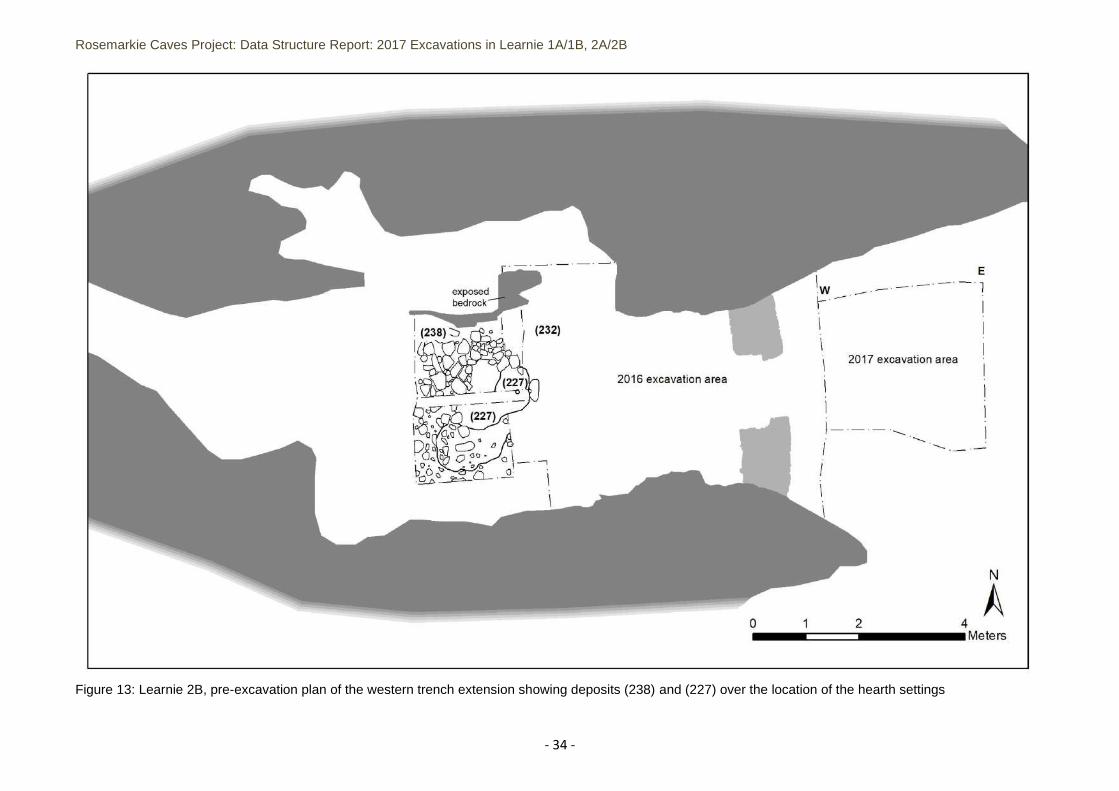
Figure 13: Learnie 2B, pre-excavation plan of the western trench extension showing deposits (238) and (227)
over the location of the hearth settings ...................................................................................................... - 34 -
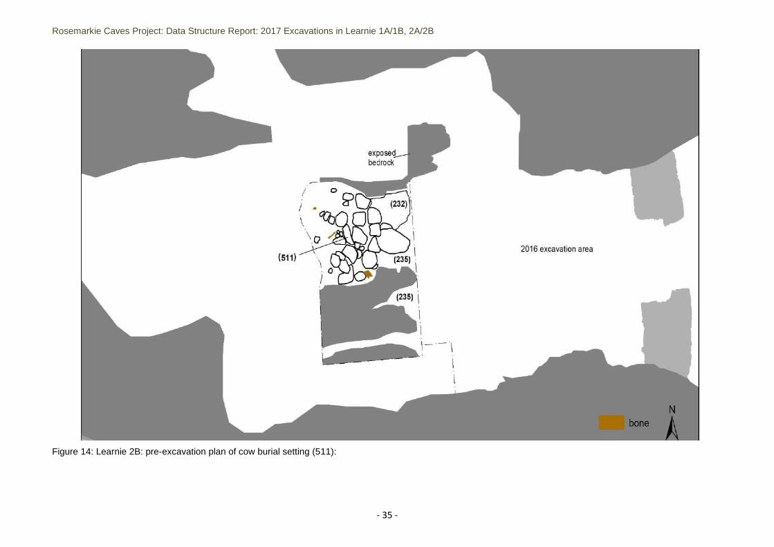
Figure 14: Learnie 2B: pre-excavation plan of cow burial setting (511): ..................................................... - 35 -
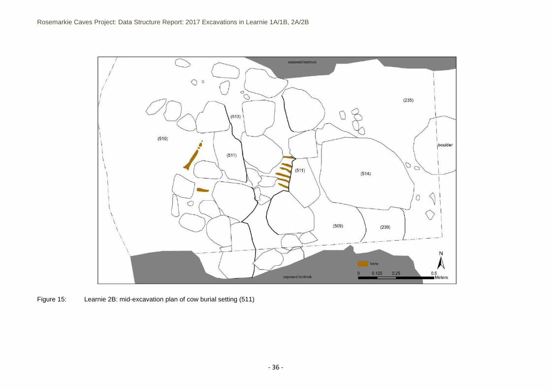
Figure 15: Learnie 2B: mid-excavation plan of cow burial setting (511) .................................................. - 36 -
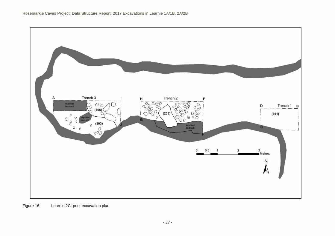
Figure 16: Learnie 2C: post-excavation plan ............................................................................................. - 37 -
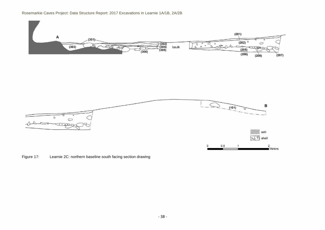
Figure 17: Learnie 2C: northern baseline south facing section drawing................................................... - 38 -
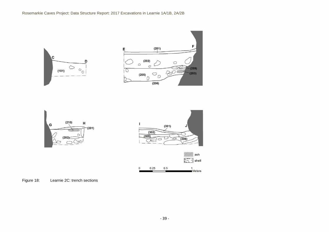
Figure 18: Learnie 2C: trench sections ...................................................................................................... - 39 -
List of Plates
Plate 1: Looking WNW towards the cave entrances at Learnie 1A (left) and Learnie 1B (right)………………- 13 -
Plate 2: Looking WNW across the entrances to Learnie 2B (left), with the 2016 spoil heap in front, and
Learnie 2C (right)……………………………………………………………………………………………………………………………………- 13 -
Plate 3: Looking E over excavations in Learnie 1A ....................................................................................... - 16 -
Plate 4: Looking E over excavations in Learnie 1B ....................................................................................... - 16 -
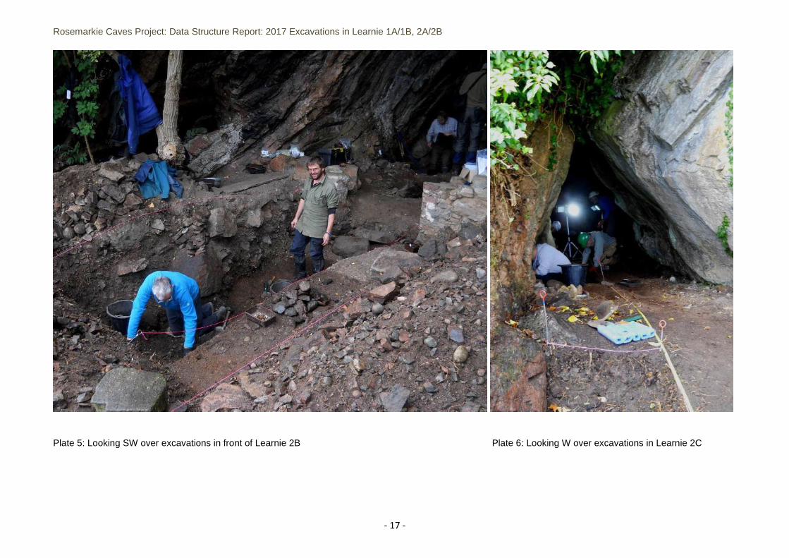
Plate 5: Looking SW over excavations in front of Learnie 2B…………………………………………………………………….-17-
Plate 6: Looking W over excavations in Learnie 2C…………………………………………………………………………………- 17 -
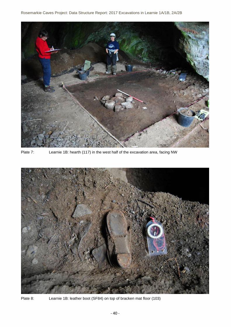
Plate 7: Learnie 1B: hearth (117) in the west half of the excavation area, facing NW .............................. - 40 -
Plate 8: Learnie 1B: leather boot (SF84) on top of bracken mat floor (103) ............................................... - 40 -
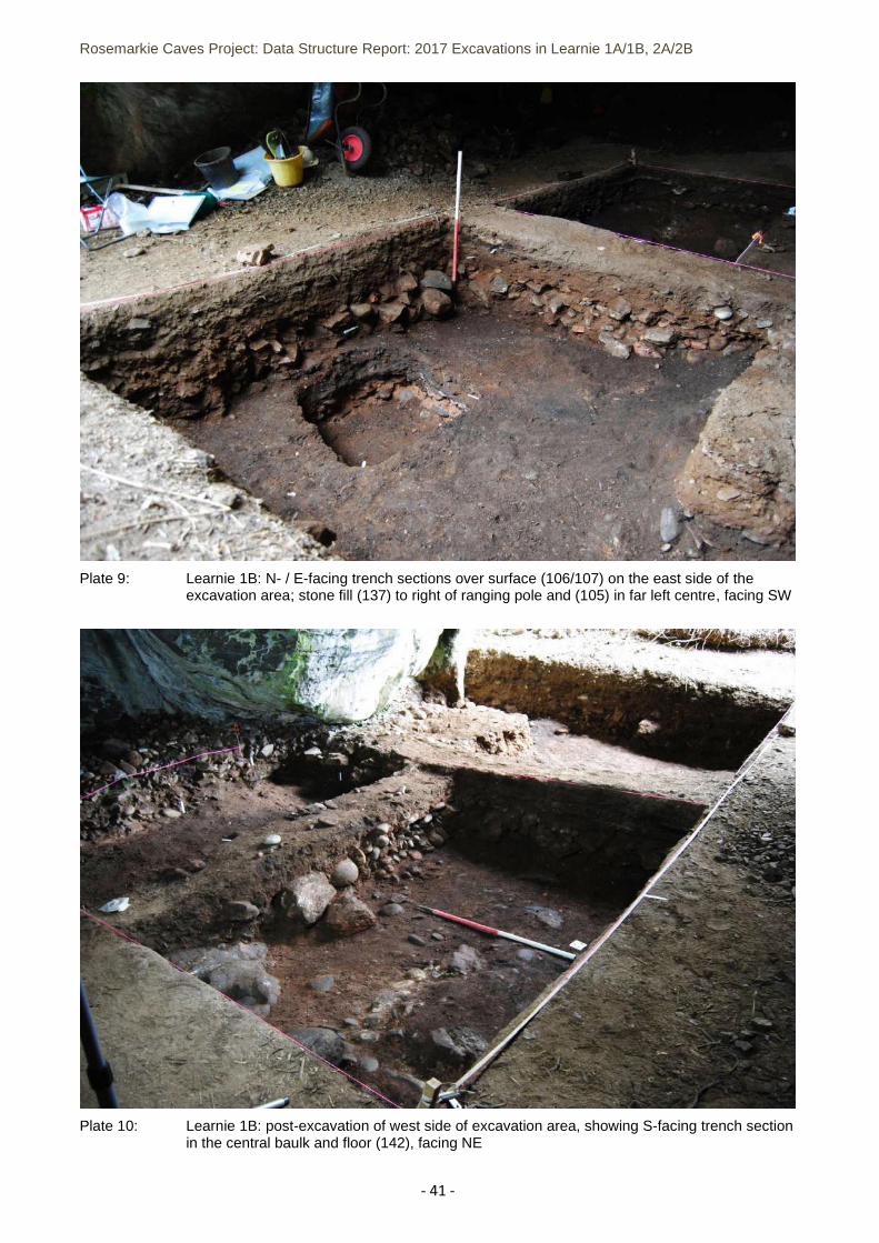
Plate 9: Learnie 1B: N- / E-facing trench sections over surface (106/107) on the east side of the excavation
area; stone fill (137) to right of ranging pole and (105) in far left centre, facing SW ................................. - 41 -
Rosemarkie Caves Project: Data Structure Report: 2017 Excavations in Learnie 1A/1B, 2A/2B
- 4 -
Plate 10: Learnie 1B: post-excavation of west side of excavaton area, showing S-facing trench secton in the
central baulk and floor (142), facing NE ...................................................................................................... - 41 -
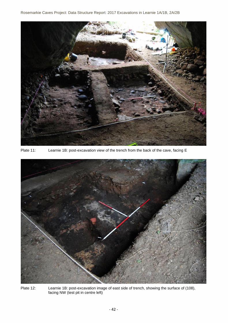
Plate 11: Learnie 1B: post-excavation view of the trench from the back of the cave, facing E ................... - 42 -
Plate 12: Learnie 1B: post-excavation image of east side of trench, showing the surface of (108), facing NW
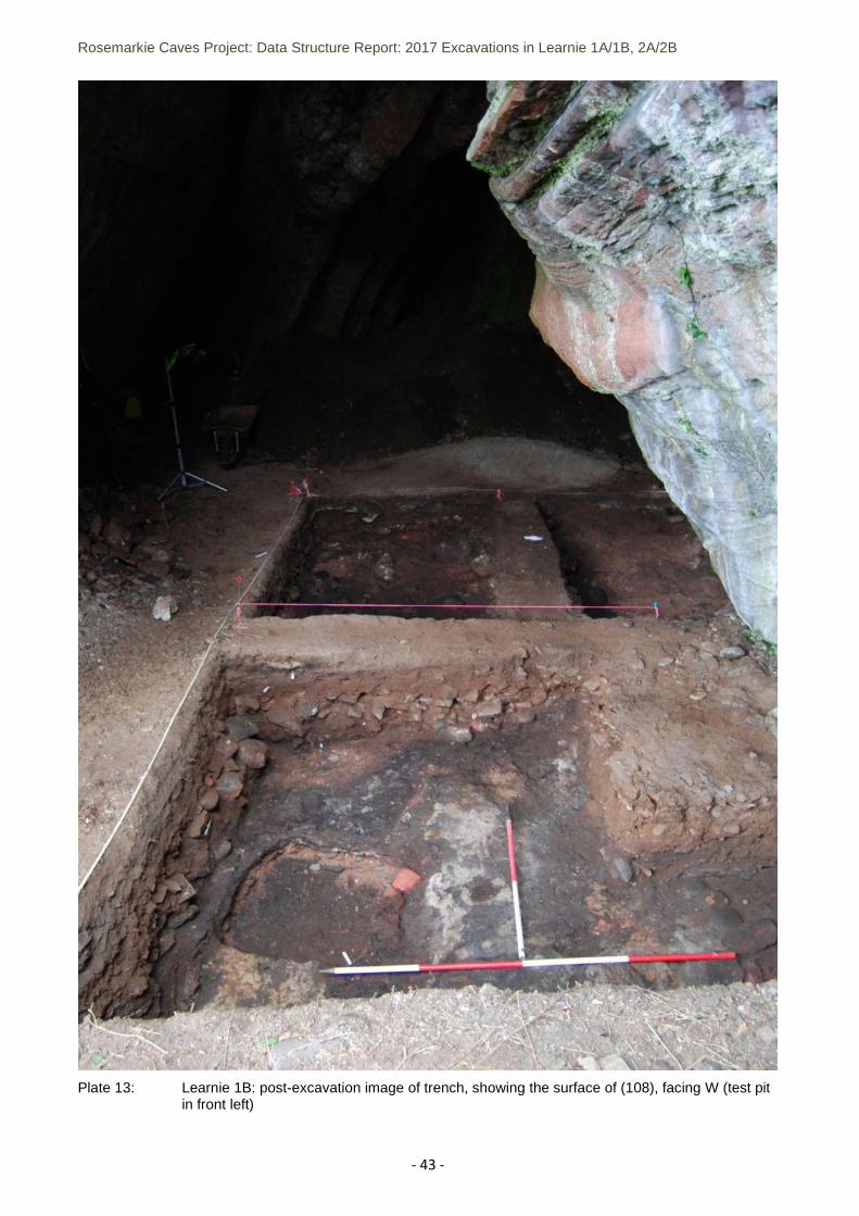
(test pit in centre left) .................................................................................................................................. - 42 -
Plate 13: Learnie 1B: post-excavation image of trench, showing the surface of (108), facing W (test pit in
front left)………………………………………………………………………………………………………………………………………………..- 43 -
Plate 14: SF130, articulated large mammal……………………………………………………………………………………….…..- 43 -
Plate 15: Clothes pin, SF109, from (116)- 44 -vertebrae in situ within (127) .............................................. - 44 -
Plate 16: SF164, cobble tool w/ central wear .............................................................................................. - 44 -
Plate 18: SF151, quern from c.137………………………………………………………………………………………………………….- 43 -
Plate 19: SF174, medicine bottle from c.305 ............................................................................................... - 44 -
Plate 20: SF175, clay pipe “Wilson’s Cutty”, c.305………………………………………………………………………………….- 43 -
Plate 21: SF158, medieval? jug sherd from c.307 ........................................................................................ - 44 -
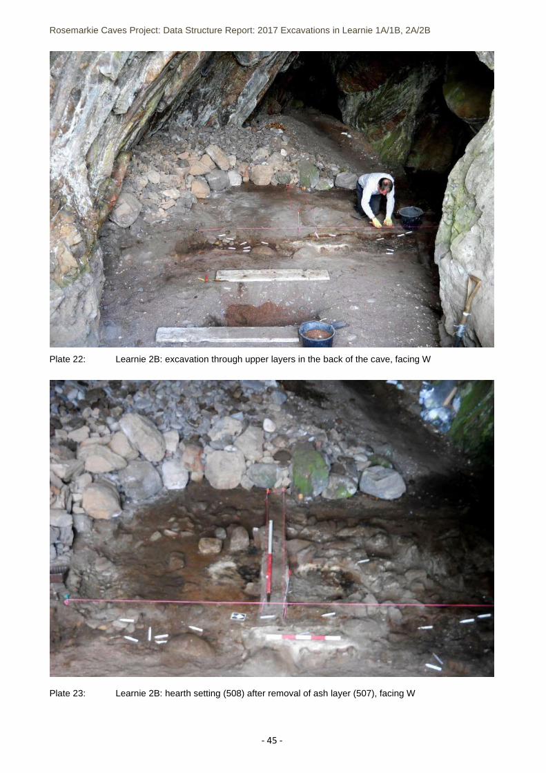
Plate 22: Learnie 2B: excavation through upper layers in the back of the cave, facing W ......................... - 45 -
Plate 23: Learnie 2B: hearth setting (508) after removal of ash layer (507), facing W ............................... - 45 -
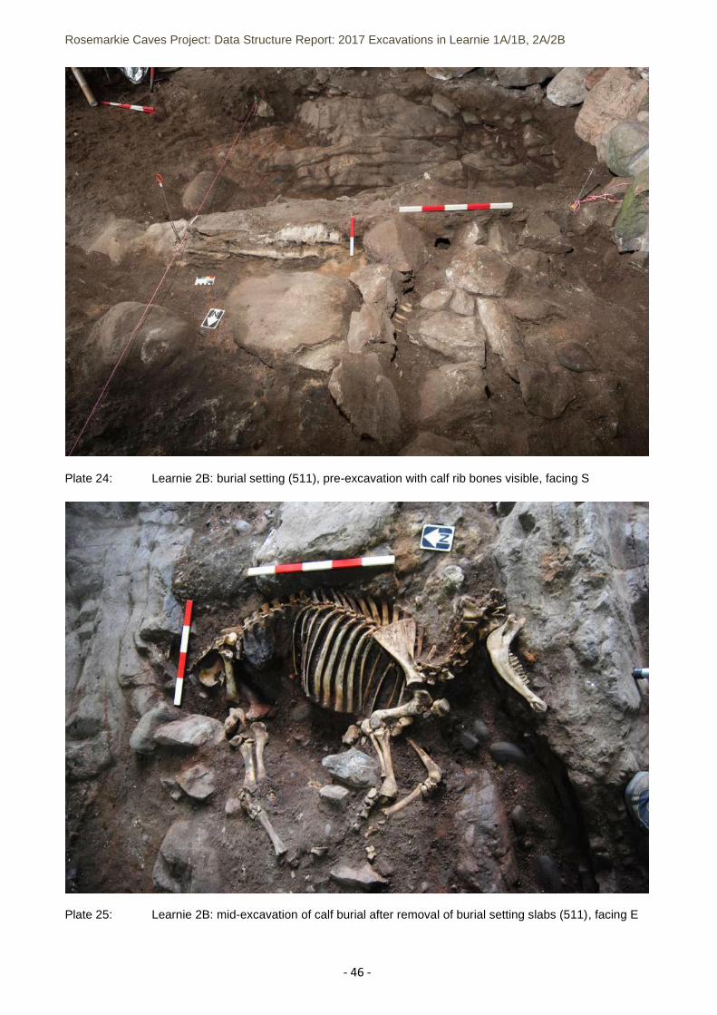
Plate 24: Learnie 2B: burial setting (511), pre-excavation with calf rib bones visible, facing S .................. - 46 -
Plate 25: Learnie 2B: mid-excavation of calf burial after removal of burial setting slabs (511), facing E .. - 46 -
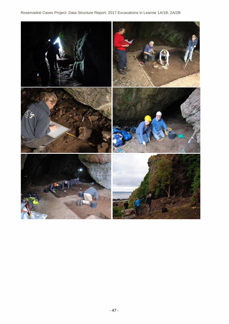
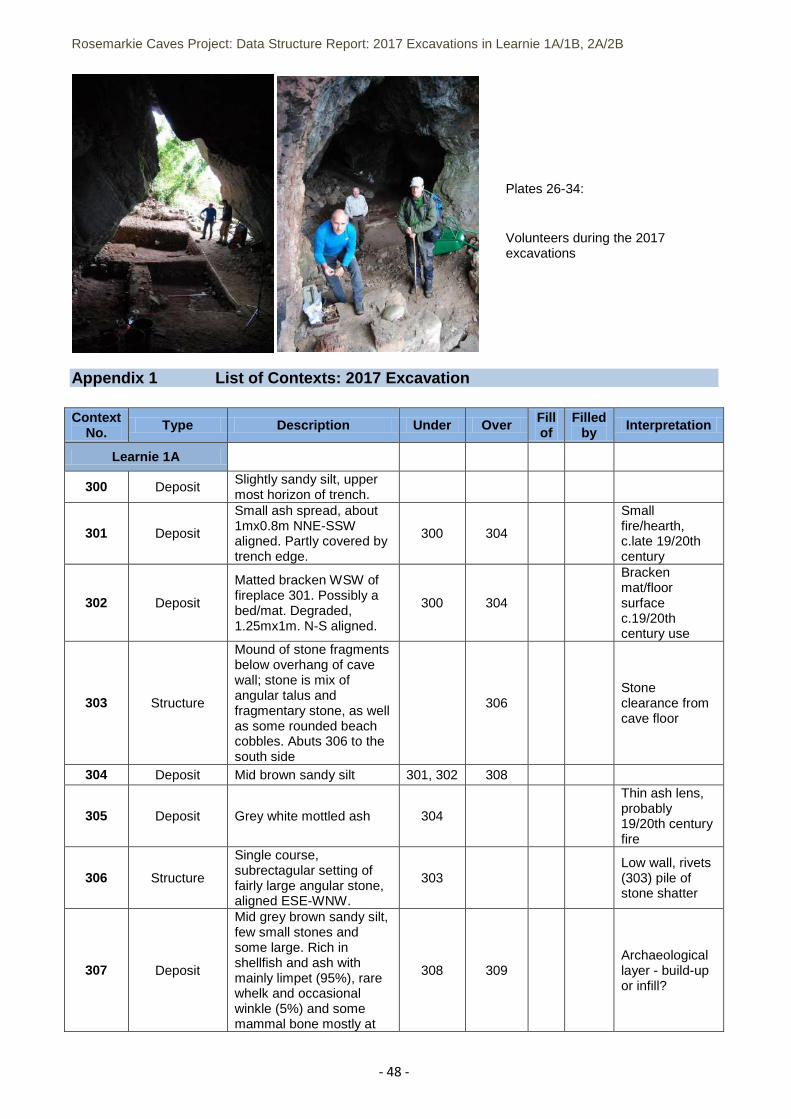
Plates 26-34: Volunteers during the 2017 excavations ............................................................................... - 48 -
List of Appendices
Appendix 1 List of Contexts: 2017 Excavation ........................................................................................... - 48 -
Appendix 2 Small Finds Register: 2017 Excavation ................................................................................... - 55 -
Appendix 3 Samples Register: 2017 Excavation ....................................................................................... - 62 -
Appendix 4 Site Plans Register: 2017 excavation ...................................................................................... - 65 -
Appendix 5 List of Photographs: 2017 excavation..................................................................................... - 67 -
Rosemarkie Caves Project: Data Structure Report: 2017 Excavations in Learnie 1A/1B, 2A/2B
- 5 -
Acknowledgements
We would like to thank the project funders: the Cromarty Trust, the Highland Council and the Hunter Historical and Archaeological Trust. Many thanks to Scottish Natural Heritage and James Gibbs for their help and support including access arrangements to the caves. We are appreciative of the help and support of the following individuals: Steven Birch, Tim Blackie, Karen Clarke, Paul Dungey, Eric Grant, Simon Gunn, Bob Jones, Rosemary Jones, Allan Mackenzie, James McComas, Mary Peteranna, Sam Williamson, Janet Witheridge and Robin Witheridge. Thank you to the volunteers from North of Scotland Archaeology Society (NOSAS). We would like to thank specially Dame Professor Sue Black and the staff from the Centre for Anatomy and Human Identification, University of Dundee, and Dr Gordon Noble and Kate Britton of the University of Aberdeen for their continued support. The project was also supported by the CARD fund.
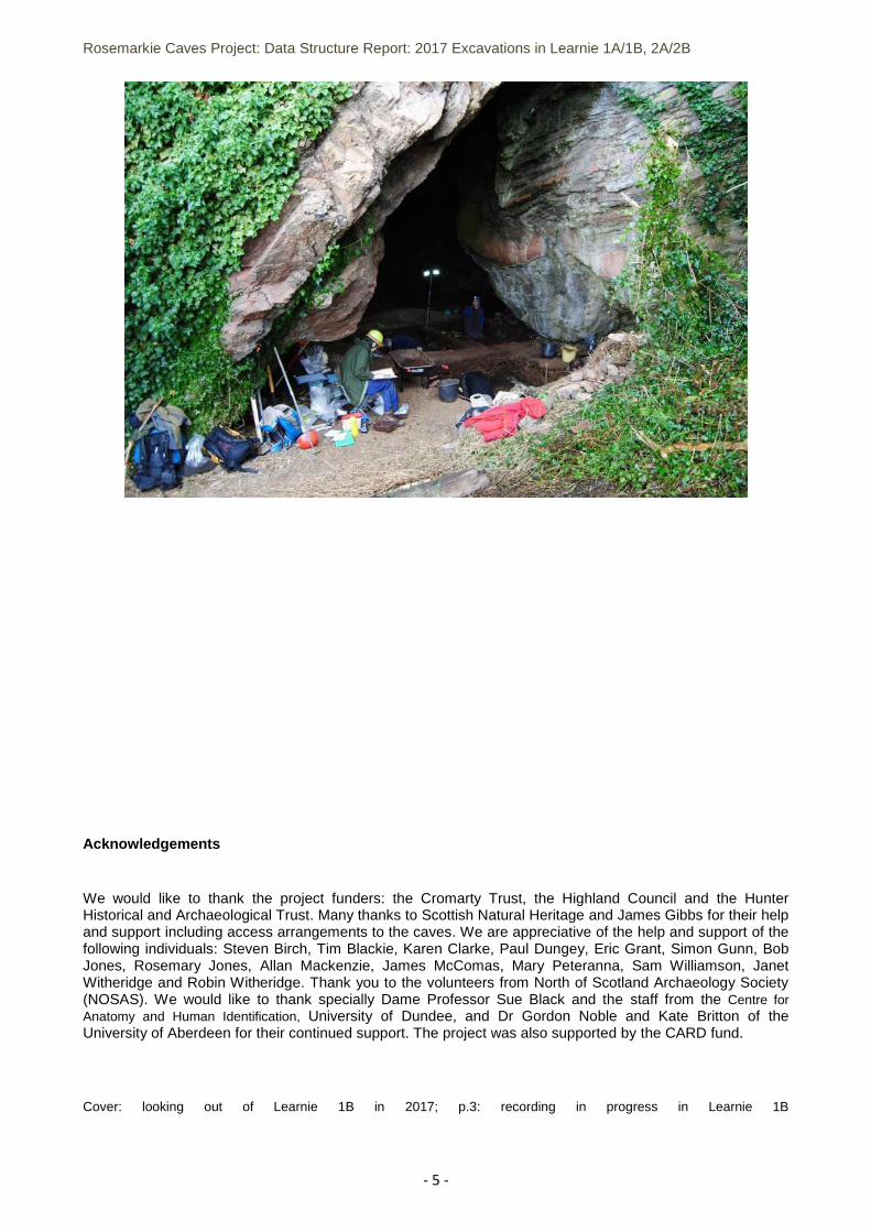
Cover: looking out of Learnie 1B in 2017; p.3: recording in progress in Learnie 1B
Rosemarkie Caves Project: Data Structure Report: 2017 Excavations in Learnie 1A/1B, 2A/2B
- 6 -
1 SUMMARY 1.1 The purpose of the Rosemarkie Caves Project is to investigate the archaeology of 19 caves on the
southeast side of the Black Isle, near Inverness. The project is run by a team of voluntary professional and amateur archaeologists. Previous fieldwork included excavation inside Caird’s Cave in 2010, baseline survey of the caves and test pit excavation in eight caves between 2011-2015 and excavation inside Learnie 2B in 2016.
1.2 During 2016, the Learnie 2B excavation uncovered significant archaeological results. In a side alcove
of the cave, the grave of a 5th/6th century male inhumation ‘deviant’ burial was uncovered, representing the earliest activity in the cave. After this, adjacent to the burial site, iron smithing took place within a defined area that respected the location of the grave. Later use of the cave took place during the medieval and post-medieval periods, with significant occupation material representing at least transient use during multiple periods. In 2017, further excavation was undertaken in Learnie 2B to complete excavation in the back of the cave. Below c.19th century fire layers, a burial setting contained the mostly complete skeleton of a young calf. The burial had been constructed over the rising natural bedrock, and late 19th century material was found within the skeletal remains – suggesting that the burial had taken place during this period unless it had been disturbed in antiquity.
1.3 In 2013 in Learnie 1B, two test pits revealed significant archaeological potential. The 2017 excavation in Learnie 1B covered the location of the test pit within an area extending 7m into the cave from the entrance along the northern wall of the cave. An extensive burnt ash surface formed the termination point for excavation in 2017 at a depth of 0.8-0.9m below the modern floor level near the cave entrance. It was located below a deep stone and sediment layer that formed the underlying deposit for the upper sequence of late- / post- medieval archaeological layers, which included a bracken mat floor, spot fires and small hearth settings and an array of artefacts including worked bone/horn, leather shoes and personal objects. A rubble stone wall and stone clearance pile formed remnants of built features still visible on the surface of the cave floor. Further excavation is planned in Learnie 1B in 2018 to establish the significance of the ash layer and associated deposits.
1.4 In Learnie 1A, a small trench was excavated near the entrance of the cave in 2017, revealing a deep stratigraphic sequence below a post-medieval / Victorian upper sequence. A sherd of possible medieval pottery was found within a deep layer that also contained animal bone and shell midden material and overlay an ash/charcoal-rich deposit. This cave has potential for further investigation, and probably had occupation episodes that coincided with Learnie 1B.
1.5 Excavation was also undertaken in Learnie 2C in 2017. A narrow, dark cave, the archaeological material survived as a short sequence of layers, including spot fires, that contained mostly late 19th century artefacts including worked horn, ceramic and bottle glass sherds.
1.6 This report contains the full results of the 2017 excavations in Learnie 1A, Learnie 1B, Learnie 2B and Learnie 2C, which was undertaken in September 2017. The full data lists from the fieldwork are supplied in the appendices. Recommendations have been made for post-excavation analysis.
2 LOCATION AND GEOLOGY
2.1 The Rosemarkie Caves Project (RCP) identified 19 caves on the Moray Firth shoreline northeast of
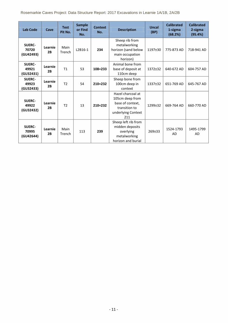
Rosemarkie on the Black Isle in Ross-shire, Scotland. The most southerly cave is situated approximately 9 miles northeast of Inverness. The group of south- and east- facing caves are located between 3-10m above the present highwater mark and most would have been large enough to be occupied permanently or intermittently. The Learnie group of caves are in a small headland on the east-facing coastline below Learnie Farm (NH 755 610) (Figure 2).
Rosemarkie Caves Project: Data Structure Report: 2017 Excavations in Learnie 1A/1B, 2A/2B
- 7 -
2.2 The caves formed at the base of cliffs comprising psammite, a brittle and easily fractured stone that over time has formed talus mounds at the entrances to many of the caves. The 2-mile stretch of coastline runs northeast to southwest comprising rocky outcrops and offshore reef complexes that would have been accessible only to small boats, while a number of access tracks descend the steep, vegetated slopes from the northwest. The section of coast is a Site of Special Scientific Interest (SSSI), under the protection of Scottish Natural Heritage.
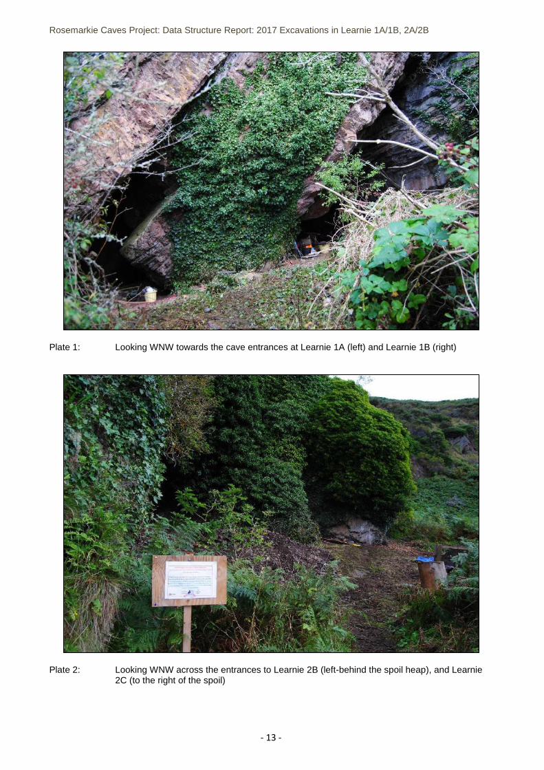
2.3 Learnie 1B is the biggest of the 19 caves. At 5m OD, Learnie 1B has an entrance 7 metres across, extends for 21 metres to the back and has a maximum ceiling height of 5 metres. At its widest, the interior measures 10 metres across. The back of the cave splits into 2 tunnels and the floor is mostly flat. Against the south wall, just inside the entrance, was a small, low rubble wall retaining a small stone pile, while a second stone pile was located against the north wall against an interior alcove. To the south of the main cave, Learnie 1A forms almost an adjunct to Learnie 1B (Plate 1). Learnie 1A is 9 metres deep and nearly 6.5 metres across. The floor is strewn with collapsed cliff shatter and contained 2 small stone piles against the base of the north wall.
2.4 Learnie 2B (Plate 2) is a large cave with a fairly flat floor composed of sand and rocks, with opposing stone-built walls breaching the entrance. The cave, situated at 5 metres OD at the entrance prior to excavation, was easily accessible and unhindered by talus banks or other debris. To its north side, Learnie 2C measured 11 meters long with a mostly flat floor that contained signs of interior fire spots.
3 ARCHAEOLOGICAL AND HISTORICAL BACKGROUND 3.1 2010 Caird’s Cave Excavation 3.1.1 In 2010, the Rosemarkie Caves Project undertook an excavation in Caird’s Cave, located southeast
of the Learnie group of caves. The purpose of the fieldwork was to establish the extent of antiquarian excavations by Maclean and Hall (1907-1912), which had yielded an important assemblage of prehistoric bone tools. The 2010 excavation revealed the presence of in situ deposits, from which a bone pin and bone working debris similar to Maclean and Hall’s assemblage were recovered. Charcoal and bone samples from the excavated sequences were radiocarbon dated from 4th - 3rd century BC to the 2nd - 3rd century AD while further radiocarbon dates obtained from worked bone and antler artefacts from the Maclean and Hall assemblage dating to the 2nd/3rd century AD and the 7th/8th century AD. Also, as part of this work, a small stone structure outside of the cave that had been occupied by travellers during the late 19th to early 20th centuries was also investigated (Anderson-Whymark 2011).
3.2 2011-2015 Test Pitting
3.2.1 The Rosemarkie Caves Project conducted test pitting in eight of the caves (Gunn and Peteranna 2016), four of which were located in the Learnie group (1B, 2B, 3B and 3C). Stratified samples of animal bone and charcoal from archaeological layers in the cave test pits provided evidence for occupation during multiple periods within the 6th-9th centuries in the Learnie cave group, with 2nd-4th century and 11th-12th century dates also derived from material in Learnie 3C. Significant evidence for 19th-20th century traveller occupation was found across the caves, particularly in the Learnie group and Ivy Cave, with frequent evidence for leather shoe-making or repair. Learnie 1B and Learnie 2B were highlighted as particularly intriguing given a depth of at least 1m of archaeological material near the front of the caves. Archaeological sequences were also found in Broad Cave and Through & Through Cave, where dated samples indicated that the caves were used within the 10th-12th and 14th-17th centuries. In 3 Peaks Cave, whose entrance is buried deep below a build-up of talus, charcoal obtained from a small stone-built setting provided a 1st-3rd century date.
3.2.2 In Learnie 1B, three test pits were excavated: in the cave entrance, on the south side of the cave through a stone pile and inside the cave floor within the north alcove. Test Pit 1 was located at the
Rosemarkie Caves Project: Data Structure Report: 2017 Excavations in Learnie 1A/1B, 2A/2B
- 8 -
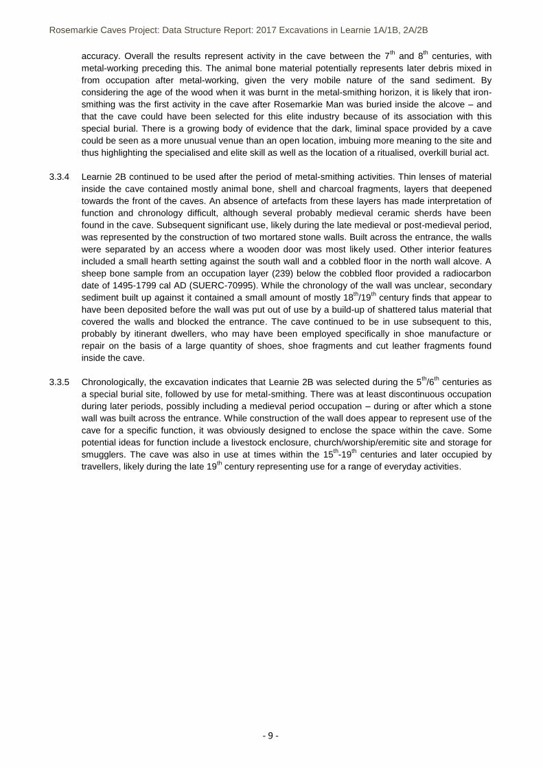
entrance to the cave and contained a sequence of up to 14 stratified layers (Figure 1). Material comprising 19th / 20th century midden material (iron, glass, ceramics and leather) was confined to the upper layers. Below context 104, the sequence of deposits indicated a lengthy continuity of occupation, with animal bone and shellfish remains appearing alongside evidence for burning. In particular, a slabbed layer (110) within an ash/charcoal lens (108) was interpreted as a possible hearth structure. A fragment of cattle bone from context (111) provided a radiocarbon date of 689-889 cal AD (SUERC-49920) and a single entity hazel charcoal sample from (112) provided a radiocarbon date of 769-965 cal AD (SUERC-49919) (Table 1). Test Pit 2 was excavated against the south wall, inside the cave, through a built pile of sharp stone sherds of similar size and type. The spread of the stone covered a linear rubble-built wall (207) comprising 1-3 courses of large stone clasts and cobbles that was interpreted as a late 19th century/ early 20th century wall and would have formed a break or partition within the cave, similar to later walls on the surface of cave Learnie 2B. The small finds in test pit 2 included a penknife with a bone handle, a metal clasp, a clay pipe bowl, a child’s leather shoe, an iron axe head, newspaper clippings and a copper coin. Thin underlying layers contained shell midden material contained finds of a similar period and the lowest archaeological horizon (205) excavated indicated a transition, being free of post-medieval material while animal bone was still present. Test Pit 3 was excavated inside the cave, to the north of a ridge of guano (bird droppings). The shallow sequence of archaeological deposits contained remains of a spot fire associated with 19th / 20th century objects including leather offcuts and broken pot sherds, glass bottles and clay pipes before reaching bedrock.
3.3 Excavation in Learnie 2B 3.3.1 Prior to 2016, excavation had been undertaken in Learnie 2B during 2006 with test pit excavation
following on from this in 2013 – further details of which are in previous reports. One surprise finding during analysis of the 2006 archive was identification of an uncatalogued 2nd century Tetricus I Roman coin (SF235), the origin of which is still a mystery.
3.3.2 The 2016 open-area excavation uncovered significant archaeological results (Birch and Peteranna
2017), including evidence for iron-working activity and a 5th/6th century AD male inhumation burial (named Rosemarkie Man). Found in a dark alcove below a post-medieval cobbled floor and midden deposits, the burial comprised the well-preserved remains of a young male who had suffered severe, multiple trauma to the head. The individual had been placed in an unmarked grave in a position with splayed legs with stones weighting down the limbs showing similarities to deviant-type burials, ones which are treated differently from the norm for potential reasons such as a communal ritual offering, an act of remembrance or to render a corpse safe from returning after death. An offering of cattle and horse bones (Kennedy 2018) had been laid over the location of the head, while additional cattle bones were found around the chest area of the inhumation. A series of four radiocarbon dates (Table 1), two from rib fragments of Rosemarkie Man and two from the animal bone offering, have indicated that his death occurred between the first half of the 5th century and the first half of the 6th century AD.
3.3.3 During a period after the burial was inserted in the cave, the cave was used for a small-scale iron-
working industry. A group of pits and cobbled features associated with iron slag, iron scale, furnace base fragments and a piece of a tuyère showed that metal-smithing was undertaken inside a defined area that respected the site of the burial. The suite of features indicated that the industry took place around an area of small work surfaces and hearth settings, within a defined work zone in the back of the cave. Three archaeological layers (232, 233, 234) were isolated within the lowest deposit overlying the basal sand layer (235) where the metal-working features were clearly identified. One radiocarbon date obtained from a sheep rib from (234) provided a date range of 718-941 cal AD (SUERC-70720). A second radiocarbon date from alder charcoal from (235) provided a date range of 670-770 cal AD (SUERC-77435). The earlier date from the basal layer (235) corresponds with three radiocarbon date ranges obtained from 3 samples of indet mammal/sheep bone and hazel charcoal from layers at the base of the test pit that provided ranges of 604-757 cal AD, 645-767 cal AD and 660-770 cal AD (Table 1). Although the test pit layers had been tentatively linked to contexts (232/233) by the author, the correlation of the horizons was found to be difficult to establish with any
Rosemarkie Caves Project: Data Structure Report: 2017 Excavations in Learnie 1A/1B, 2A/2B
- 9 -
accuracy. Overall the results represent activity in the cave between the 7th and 8th centuries, with metal-working preceding this. The animal bone material potentially represents later debris mixed in from occupation after metal-working, given the very mobile nature of the sand sediment. By considering the age of the wood when it was burnt in the metal-smithing horizon, it is likely that iron-smithing was the first activity in the cave after Rosemarkie Man was buried inside the alcove – and that the cave could have been selected for this elite industry because of its association with this special burial. There is a growing body of evidence that the dark, liminal space provided by a cave could be seen as a more unusual venue than an open location, imbuing more meaning to the site and thus highlighting the specialised and elite skill as well as the location of a ritualised, overkill burial act.
3.3.4 Learnie 2B continued to be used after the period of metal-smithing activities. Thin lenses of material
inside the cave contained mostly animal bone, shell and charcoal fragments, layers that deepened towards the front of the caves. An absence of artefacts from these layers has made interpretation of function and chronology difficult, although several probably medieval ceramic sherds have been found in the cave. Subsequent significant use, likely during the late medieval or post-medieval period, was represented by the construction of two mortared stone walls. Built across the entrance, the walls were separated by an access where a wooden door was most likely used. Other interior features included a small hearth setting against the south wall and a cobbled floor in the north wall alcove. A sheep bone sample from an occupation layer (239) below the cobbled floor provided a radiocarbon date of 1495-1799 cal AD (SUERC-70995). While the chronology of the wall was unclear, secondary sediment built up against it contained a small amount of mostly 18th/19th century finds that appear to have been deposited before the wall was put out of use by a build-up of shattered talus material that covered the walls and blocked the entrance. The cave continued to be in use subsequent to this, probably by itinerant dwellers, who may have been employed specifically in shoe manufacture or repair on the basis of a large quantity of shoes, shoe fragments and cut leather fragments found inside the cave.
3.3.5 Chronologically, the excavation indicates that Learnie 2B was selected during the 5th/6th centuries as
a special burial site, followed by use for metal-smithing. There was at least discontinuous occupation during later periods, possibly including a medieval period occupation – during or after which a stone wall was built across the entrance. While construction of the wall does appear to represent use of the cave for a specific function, it was obviously designed to enclose the space within the cave. Some potential ideas for function include a livestock enclosure, church/worship/eremitic site and storage for smugglers. The cave was also in use at times within the 15th-19th centuries and later occupied by travellers, likely during the late 19th century representing use for a range of everyday activities.
Rosemarkie Caves Project: Data Structure Report: 2017 Excavations in Learnie 1A/1B, 2A/2B
- 10 -
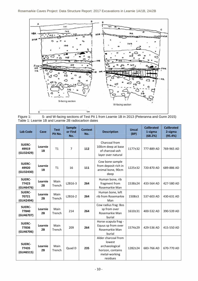
Figure 1: S- and W-facing sections of Test Pit 1 from Learnie 1B in 2013 (Peteranna and Gunn 2015) Table 1: Learnie 1B and Learnie 2B radiocarbon dates
Lab Code Cave Test
Pit No.
Sample or Find
No.
Context No.
Description Uncal (BP)
Calibrated 1-sigma (68.2%)
Calibrated 2-sigma (95.4%)
SUERC-49919
(GU32429)
Learnie 1B
T1 7 112
Charcoal from 100cm deep at base
of charcoal-ash layer over natural
1177±32 777-889 AD 769-965 AD
SUERC-49920
(GU32430)
Learnie 1B
T1 16 111
Cow bone sample from deposit rich in animal bone, 90cm
deep
1225±32 720-870 AD 689-886 AD
SUERC-77423
(GU46476)
Learnie 2B
Main Trench
L2B16-3 264 Human bone, rib fragment from
Rosemarkie Man 1538±24 433-564 AD 427-580 AD
SUERC-70721
(GU42494)
Learnie 2B
Main Trench
L2B16-2 264 Human bone, left
rib from Rosemarkie Man
1508±3 537-603 AD 430-631 AD
SUERC-77840
(GU46707)
Learnie 2B
Main Trench
214 264
Cow radius frag: Bos sp from over
Rosemarkie Man burial
1610±31 400-532 AD 390-539 AD
SUERC-77836
(GU46706)
Learnie 2B
Main Trench
209 264
Horse scapula frag - Equus sp from over
Rosemarkie Man burial
1574±29 429-536 AD 415-550 AD
SUERC-77435
(GU46515)
Learnie 2B
Main Trench
Quad D 235
Alder charcoal from lowest
archaeological horizon, contains
metal-working residues
1282±24 683-766 AD 670-770 AD
Rosemarkie Caves Project: Data Structure Report: 2017 Excavations in Learnie 1A/1B, 2A/2B
- 11 -
Lab Code Cave Test
Pit No.
Sample or Find
No.
Context No.
Description Uncal (BP)
Calibrated 1-sigma (68.2%)
Calibrated 2-sigma (95.4%)
SUERC-70720
(GU42493)
Learnie 2B
Main Trench
L2B16-1 234
Sheep rib from metalworking
horizon (sand below main occupation
horizon)
1197±30 775-873 AD 718-941 AD
SUERC-49921
(GU32431)
Learnie 2B
T1 53 108=233 Animal bone from base of deposit at
110cm deep 1372±32 640-672 AD 604-757 AD
SUERC-49923
(GU32433)
Learnie 2B
T2 54 210=232 Sheep bone from
100cm deep in context
1337±32 651-769 AD 645-767 AD
SUERC-49922
(GU32432)
Learnie 2B
T2 13 210=232
Hazel charcoal at 105cm deep from base of context,
transition to underlying Context
211
1299±32 669-764 AD 660-770 AD
SUERC-70995
(GU42644)
Learnie 2B
Main Trench
113 239
Sheep left rib from midden deposits
overlying metalworking
horizon and burial
269±33 1524-1793
AD 1495-1799
AD
Rosemarkie Caves Project: Data Structure Report: 2017 Excavations in Learnie 1A/1B, 2A/2B
- 12 -
Figure 2: Location of the Learnie cave group, showing the Learnie groups of caves
Rosemarkie Caves Project: Data Structure Report: 2017 Excavations in Learnie 1A/1B, 2A/2B
- 13 -
Plate 1: Looking WNW towards the cave entrances at Learnie 1A (left) and Learnie 1B (right)
Plate 2: Looking WNW across the entrances to Learnie 2B (left-behind the spoil heap), and Learnie 2C (to the right of the spoil)
Rosemarkie Caves Project: Data Structure Report: 2017 Excavations in Learnie 1A/1B, 2A/2B
- 14 -
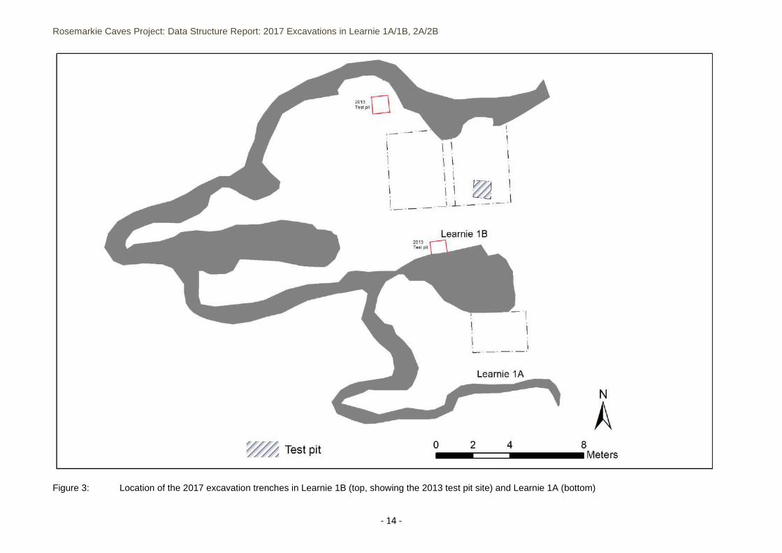
Figure 3: Location of the 2017 excavation trenches in Learnie 1B (top, showing the 2013 test pit site) and Learnie 1A (bottom)
Rosemarkie Caves Project: Data Structure Report: 2017 Excavations in Learnie 1A/1B, 2A/2B
- 15 -
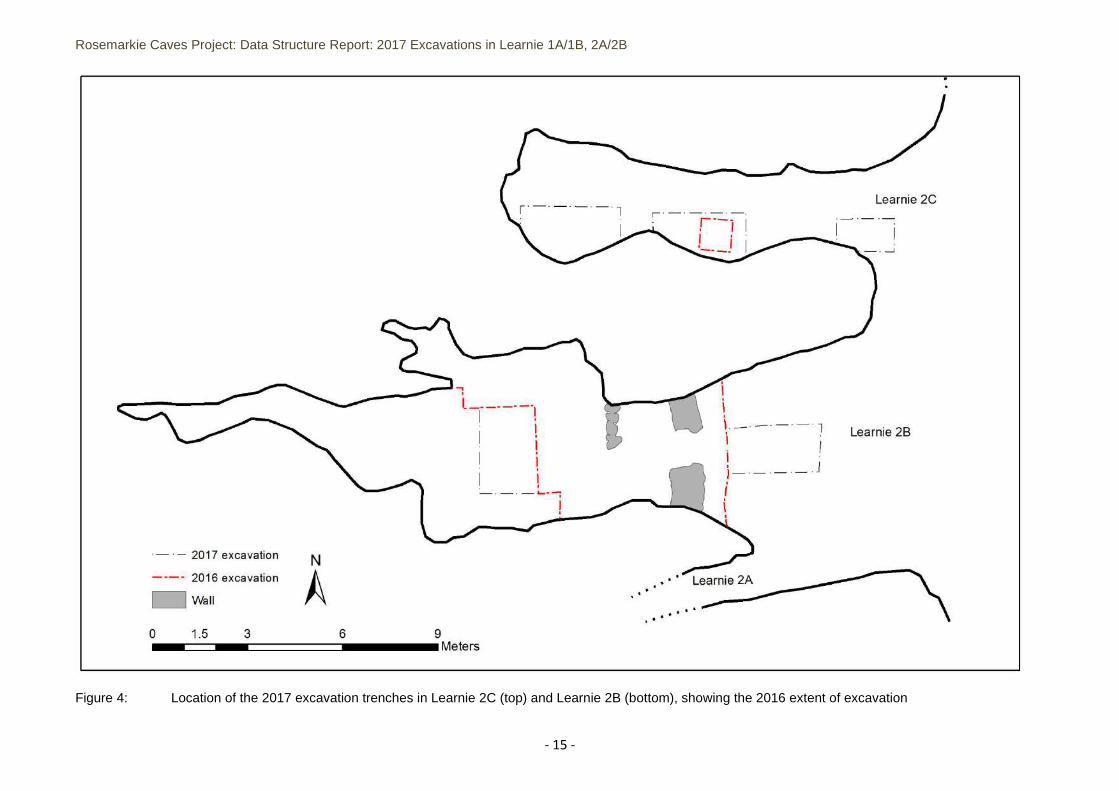
Figure 4: Location of the 2017 excavation trenches in Learnie 2C (top) and Learnie 2B (bottom), showing the 2016 extent of excavation
Rosemarkie Caves Project: Data Structure Report: 2017 Excavations in Learnie 1A/1B, 2A/2B
- 16 -
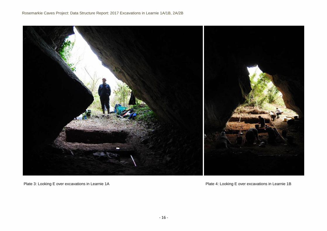
Plate 3: Looking E over excavations in Learnie 1A Plate 4: Looking E over excavations in Learnie 1B
Rosemarkie Caves Project: Data Structure Report: 2017 Excavations in Learnie 1A/1B, 2A/2B
- 17 -
Plate 5: Looking SW over excavations in front of Learnie 2B Plate 6: Looking W over excavations in Learnie 2C
Rosemarkie Caves Project: Data Structure Report: 2017 Excavations in Learnie 1A/1B, 2A/2B
- 18 -
4.0 AIMS AND OBJECTIVES 4.1 The aim of further excavation in the Learnie caves group was to better understand the archaeology of
the caves and to provide more information to support the 2016 excavation and 2012-15 test pitting results. Open-area area in Learnie 1A uncovered the extent of a large part of the cave, investigating the overall archaeological sequence in this large cave. In the smaller cave to the south of it, Learnie 1B, a small excavation trench investigated its archaeological potential and relationship with 1A.
4.2 In Learnie 2B, targeted excavation trenches in 2017 completed excavation in the back of the cave
and investigated the extent of archaeological material outside the cave entrance, where deep stratigraphy had been uncovered in previous years. In Learnie 2C, trench excavation investigated the form, function and extent of the archaeological material identified in the 2016 test pit
4.3 The programme of fieldwork in the Learnie caves continues to investigate the overall chronology of
use of the caves and their inter-relationships. The results are providing valuable information about the caves’ occupation during the post-medieval, medieval, Early Medieval and Iron Age periods. The project continues to provide an opportunity for volunteers and students to learn archaeological techniques in the unique remote coastal location of the Cromarty-Rosemarkie shoreline environment.
4.4 The overall aims of the archaeological excavation were:
To establish the character and extent of surviving archaeological deposits in the caves To conduct excavation inside Learnie 1A, Learnie 1B and Learnie 2C and to complete excavation
inside Learnie 2B To improve our understanding of the types of activities taking place in the caves and to compare
this evidence with the findings of the test pitting programme To enhance the archaeological record To provide training in archaeological excavation and recording techniques to students and
volunteers To encourage the inclusion of local people in the discovery, discussion and outcome of the
project, and to develop practical, research and educational benefits for the community as a whole To publish and report on the archaeological results to the wider public and research community
4.5 The specific objectives of the archaeological evaluation were:
To conduct an open area excavation in Learnie 1B and 2C, to expose in plan any structures or features of archaeological significance
To excavate evaluation trenches near the entrances of Learnie 1A and 2B to investigate the potential for further archaeological discoveries
To excavate, by context, the archaeological horizons in the cave To expose the extent of archaeological deposits and features inside the caves To recover environmental samples and artefacts which will assist interpretation and chronology
of the past activities taking place in the caves, and inform on overall site function To collate the 2017 fieldwork data and undertake further research to inform future excavation To make proposals post-excavation specialist analysis
5.0 METHODOLOGY 5.1 Permissions 5.1.1 Prior to excavation, the landowners permission was obtained, and the cave was assessed for any
changes since the 2016 excavation. Fieldwork was scheduled to comply with Scottish Natural Heritage guidance on bat nesting seasons.
Rosemarkie Caves Project: Data Structure Report: 2017 Excavations in Learnie 1A/1B, 2A/2B
- 19 -
5.2 Learnie 1A and Learnie 1B 5.2.1 In Learnie 1A, a small trench measuring 3m E-W by 2m was excavated (Figure 3; Plate 3). It was
located near the entrance of the cave and extended inside against the northern cave wall. Upper contexts were excavated in plan and a sub-trench was excavated over the eastern 1m of the trench to evaluate the archaeological potential.
5.2.2 In Learnie 1B, open area excavation was undertaken within a trench measuring 7m E-W by 4m
(Plate 4; Figure 3). It covered the location of the 2013 test pit and abutted the northern wall of the cave. Contexts were excavated in plan and correlated with the 2013 stratigraphic sequence, where possible.
5.3 Learnie 2B and Learnie 2C 5.3.1 In Learnie 2B, a small excavation trench measuring 3m N-S by 2m extended the 2016 excavation
area in the back of the cave in order to complete the excavation in this cave (Figure 4). Contexts were excavated in plan, in order to expose and record any features and to remove the last archaeological horizon in the cave.
5.3.2 Also in Learnie 2B, an evaluation trench measuring 3m E-W by 2m was excavated in the entrance to
the cave, to expose the extent of the archaeological sequence outside the stone walls exposed in 2016 (Figure 4, Plate 5). Contexts were excavated in layers for the purpose of the recovery of archaeological material. There were no features encountered.
5.3.3 In Learnie 2C, open area excavation was undertaken within three trenches separated by baulks
against the south wall of this narrow cave (Figure 4, Plate 6), focussing on the interior of the cave but exposing the area just outside the cave mouth. Trench 1 measured 1.5m E-W by 1m, Trench 2 measured 2m E-W by 1m and Trench 3 measuring 2m E-W by 1m. Trench 2 covered the location of the 2016 test pit. Contexts were excavated in plan down to the natural subsoil or bedrock in Trench 2 and Trench 3. In Trench 1, due to time constraints, only the upper topsoil horizon was removed.
5.4 Excavation 5.4.1 Open area excavation was undertaken, following a single context recording system based on
standard stratigraphic principles. Excavation was undertaken using baulk standing sections with a base site datum set up at the mouth of the caves opposing a second datum set up at the back of the cave and forming the baseline for excavation and recording. Baseline levels were calculated using a standard dumpy level, with measurements taken from a fixed point on the shore retrieved using a Trimble Geo-XR rover using VRS-Now (RTK) corrections rated at centimetre accuracy.
5.4.2 All artefacts and ecofacts were hand retrieved and sorted on site. Dry sieving was undertaken on site
for certain key deposits. Bulk sampling of all archaeological layers was undertaken and a minimum of 50% of cut fills were sampled for environmental analysis.
5.4.3 Recording was undertaken using standard recording sheets, plan and section drawings (scales of
1:20 and 1:10) and high-resolution digital photography. All excavation and recording was carried out in accordance with CIfA (Chartered Institute for Archaeologists) Code of Conduct (2014) and the Highland Council Standards for Archaeological Work (2012).
5.5 Sample and finds processing 5.5.1 A single context recording system was utilised and individual artefacts or groups of finds were given
small find numbers. Where possible, finds and samples were recorded following on from the sequence established in the cave from previous excavations in 2013 and 2016. Upon completion of
Rosemarkie Caves Project: Data Structure Report: 2017 Excavations in Learnie 1A/1B, 2A/2B
- 20 -
the fieldwork, small finds and samples were checked, rapidly assessed and stored in a controlled environment. The material is being stored for future post-excavation analysis.
6 RESULTS 6.1 Learnie 1B 6.1.1 Open area excavation was undertaken in Learnie 1B in 2017. An area measuring 7m E-W by 4m with
a central baulk was excavated against the north cave wall and over the location of the 2013 test pit 1, which had revealed deep archaeological layers in the front of the cave. Prior to excavation, two further test pits (2 and 3) in 2013 had evaluated the cave deposits and recorded the location of two loose stone piles built up against the north and south cave walls, Figures 5-9 provide the stratigraphic detail of trench sections and plans of features and deposits from 2017.
6.1.2 In the eastern half of the trench, excavation in 2017 stopped at the top of an extensive ash layer
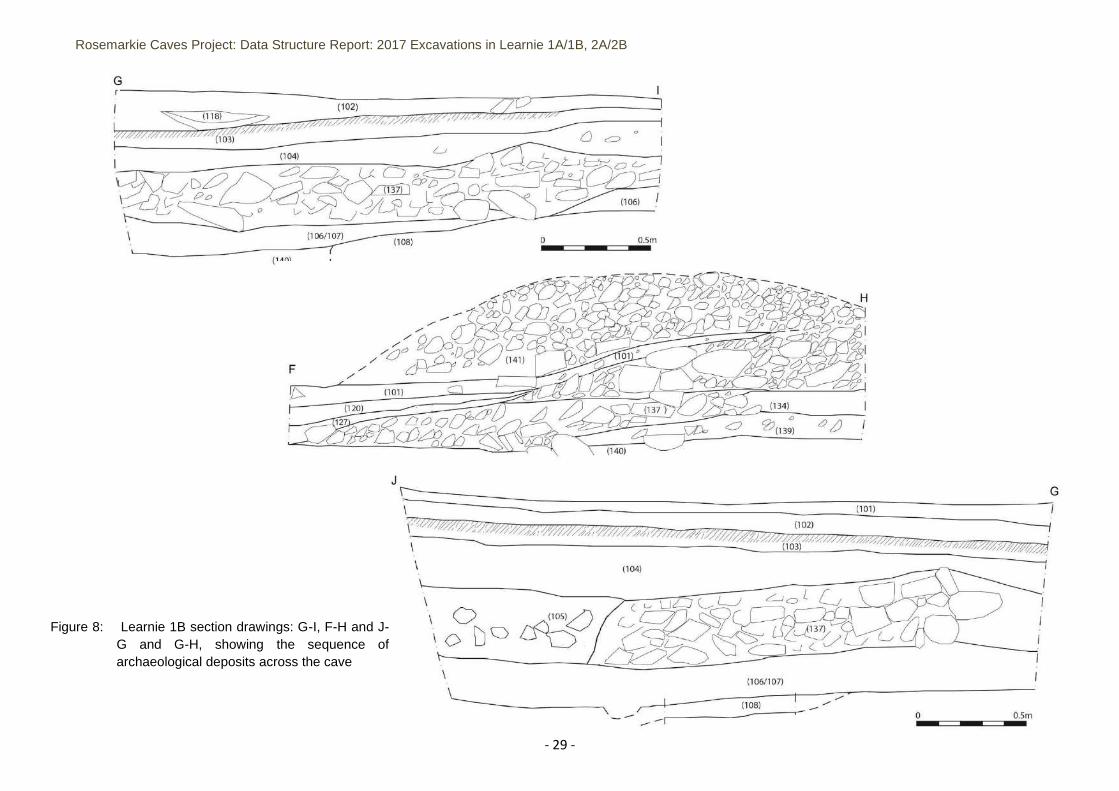
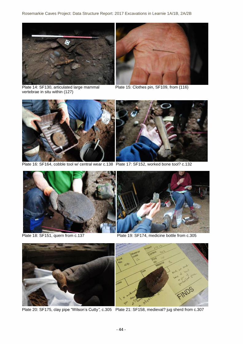
(108). The surface of context (108) was a very compact dark brown/black and pale yellow/grey/white silty ash layer with heat-cracked slabs within it (Plates 12-13). The surface rose in height towards the northern cave wall, with a more vitrified section in the northeast corner of the trench. This layer was correlated with (108) shown in the section drawing (Figure 1) from Test Pit 1 in 2013 and probably represents the surface of what appears to be an extensive ash and burning layer that runs across the eastern front half of the cave. The layer appeared to thin out and dissipate towards the west half of the excavated area below the baulk. West of the baulk, the ash layer was not located and excavation stopped at a thin, dark brown-black greasy silt overlying cobbles embedded into what appeared to be the natural underlying sand (140) (Plate 11).
6.1.3 Above the extensive ash surface, context (106/107) was excavated as one layer that corresponded
with two layers (106) and (107) in the 2013 test pit (Figure 1). It comprised loosely compacted, dark brown silt with charcoal flecks, a small amount of animal and fish bone and a small iron lump (SF204). In one discrete area, the layer contained a charcoal-rich lens with heat-affected cobbles and shell – potentially a spot fire or hearth. Samples for this deposit should provide further information about its content. Context (142) on the west side of the excavation area was interpreted as the remnants of (106) as it dissipated towards the rising back of the cave. Above this, context (139) consisted of a dark brown/black silt with patches of yellow/white ash running across the west half of the excavation trench and extending beyond the excavated area. (139) contained some clay pipe fragments (SF189) and two iron fragments (SF190), along with mammal and fish bone, shell and hazelnut shells. It was covered by a thick stony layer consisting of a mixture of large beach cobbles, small stone clasts and cobbles within a mid to pale brown sandy silt (137). This deposit is clearly visible in the centre of the trench sections with the conglomeration of cobbles (Plates 9-10), ending abruptly at both the west and east sides, as if it formed an infill layer at the centre of the cave. It contained a mixture of shell and mammal bone, with a small amount of probable late 19th century ceramics. At its eastern end, in the east half of the excavation area, the layer appeared to transition to a more homogenous layer of angular stones and possible shatter from the caves cave wall and roof - all within a silty sand (105). Context (105) is defined across the eastern edge of the excavation area, mostly below the cave dripline where collapse and silting had built up material over time. It is mostly likely that the transition from (105) to (137) represents material brought in or moved around from inside the cave to create a more level interior floor during 19th century re-occupation. A possible quern stone was recovered from context (137) (SF151) (Plate 18).
6.1.4 The stone fill layers were overlain by another deposit of mostly homogenous sandy silt (104) on the
east side of the excavation area that contained a small amount of c.19th century ceramics. At the same horizon, but towards the cave interior on the west side of the trench, layers (123), (120), (121), (127), (131) and (138) were distinguished as varying deposits from 19th century activity. The transition between layers was difficult to distinguish – with the material comprising highly mobile, organic-rich silts. Overall, the deposits potentially represent multiple periods of occupation within the post-medieval period. Two hearth features at this horizon include stone setting (128) and fire-pit (130),
Rosemarkie Caves Project: Data Structure Report: 2017 Excavations in Learnie 1A/1B, 2A/2B
- 21 -
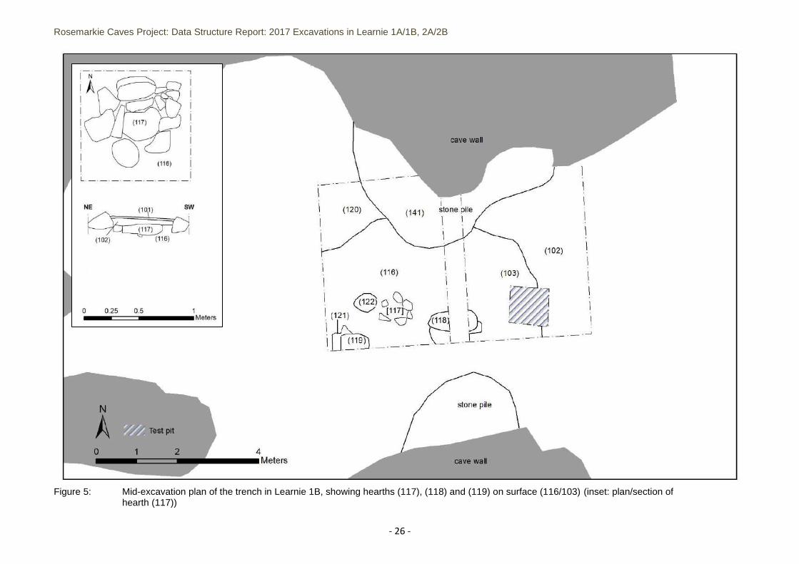
which had been built into (123)/ (127), while discrete midden dumps (125), (132) and (134) were also present. Shell, fish bone and mammal bone were recovered throughout the layers, which contained a mixture of c.19th century ceramics, bottle glass, clay pipes, stone tools and other objects representing everyday activities. Of particular interest was a small cobble with central wear (SF164) from (138) that may have been used as a grinder or anvil-type tool (Plate 16), a large animal rib bone with sawn ends used as a tool of some form (SF152) (Plate 17) from (132), and a deposit of articulated large mammal vertebrae (SF130) (Plate 14) found within contexts (127).
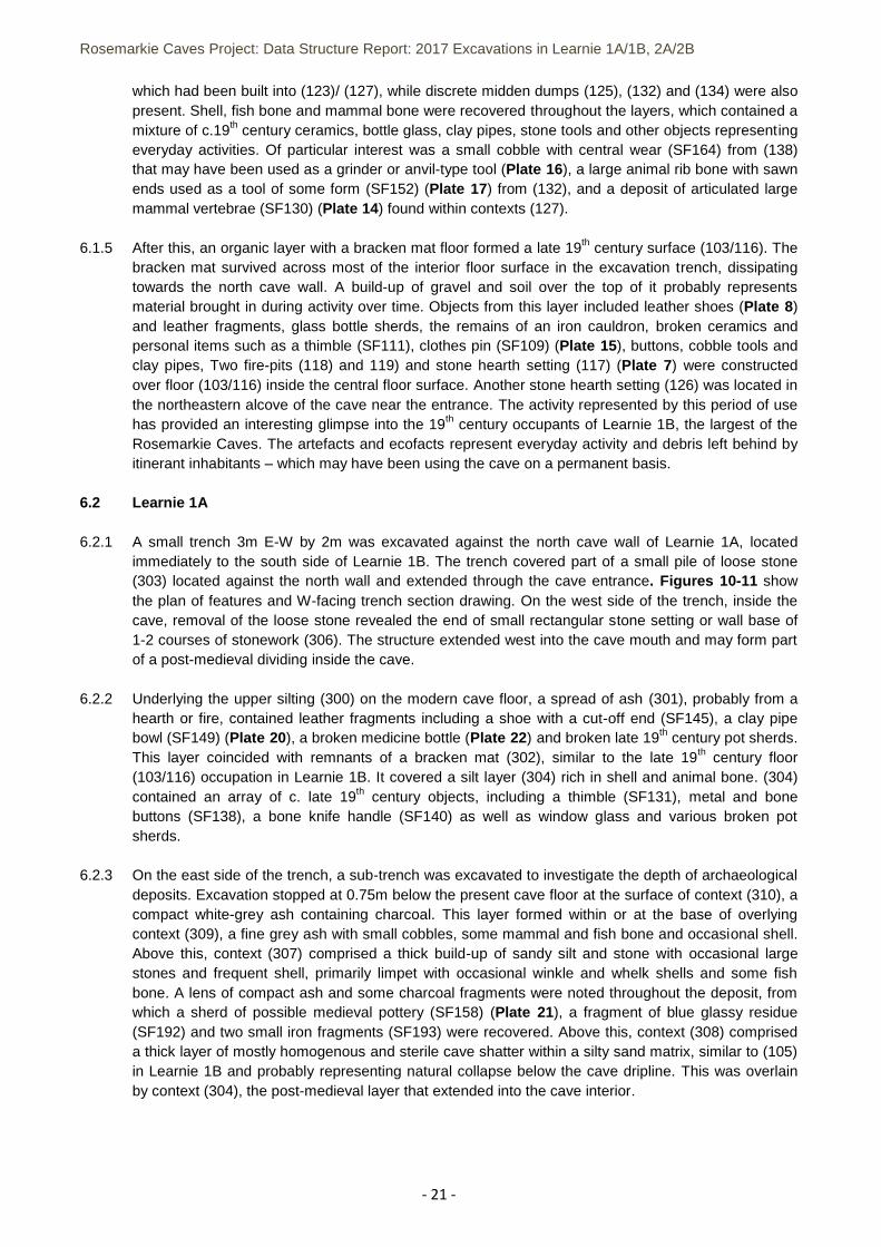
6.1.5 After this, an organic layer with a bracken mat floor formed a late 19th century surface (103/116). The
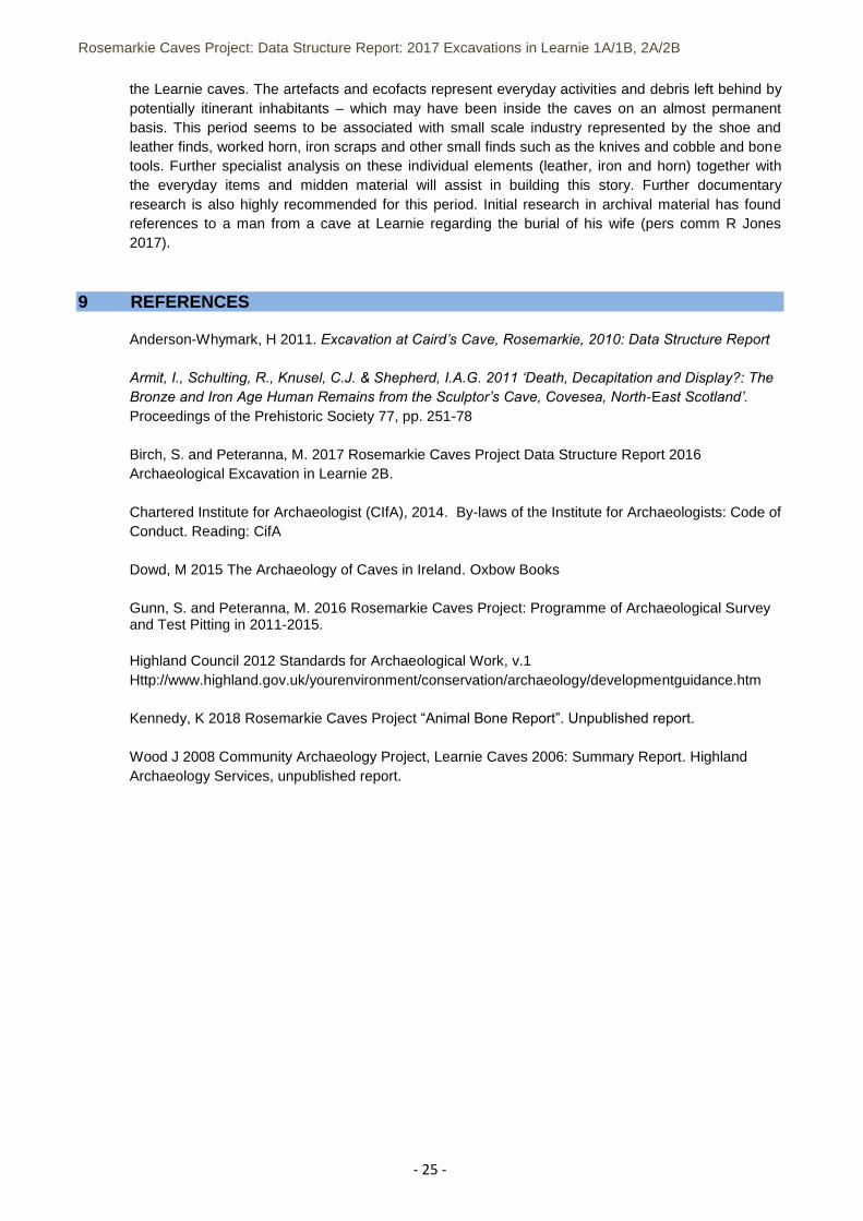
bracken mat survived across most of the interior floor surface in the excavation trench, dissipating towards the north cave wall. A build-up of gravel and soil over the top of it probably represents material brought in during activity over time. Objects from this layer included leather shoes (Plate 8) and leather fragments, glass bottle sherds, the remains of an iron cauldron, broken ceramics and personal items such as a thimble (SF111), clothes pin (SF109) (Plate 15), buttons, cobble tools and clay pipes, Two fire-pits (118) and 119) and stone hearth setting (117) (Plate 7) were constructed over floor (103/116) inside the central floor surface. Another stone hearth setting (126) was located in the northeastern alcove of the cave near the entrance. The activity represented by this period of use has provided an interesting glimpse into the 19th century occupants of Learnie 1B, the largest of the Rosemarkie Caves. The artefacts and ecofacts represent everyday activity and debris left behind by itinerant inhabitants – which may have been using the cave on a permanent basis.
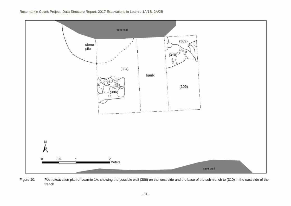
6.2 Learnie 1A 6.2.1 A small trench 3m E-W by 2m was excavated against the north cave wall of Learnie 1A, located
immediately to the south side of Learnie 1B. The trench covered part of a small pile of loose stone (303) located against the north wall and extended through the cave entrance. Figures 10-11 show the plan of features and W-facing trench section drawing. On the west side of the trench, inside the cave, removal of the loose stone revealed the end of small rectangular stone setting or wall base of 1-2 courses of stonework (306). The structure extended west into the cave mouth and may form part of a post-medieval dividing inside the cave.
6.2.2 Underlying the upper silting (300) on the modern cave floor, a spread of ash (301), probably from a
hearth or fire, contained leather fragments including a shoe with a cut-off end (SF145), a clay pipe bowl (SF149) (Plate 20), a broken medicine bottle (Plate 22) and broken late 19th century pot sherds. This layer coincided with remnants of a bracken mat (302), similar to the late 19th century floor (103/116) occupation in Learnie 1B. It covered a silt layer (304) rich in shell and animal bone. (304) contained an array of c. late 19th century objects, including a thimble (SF131), metal and bone buttons (SF138), a bone knife handle (SF140) as well as window glass and various broken pot sherds.
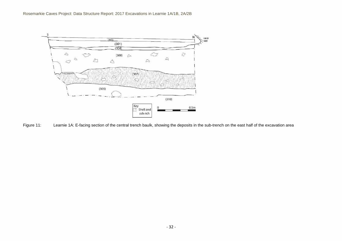
6.2.3 On the east side of the trench, a sub-trench was excavated to investigate the depth of archaeological
deposits. Excavation stopped at 0.75m below the present cave floor at the surface of context (310), a compact white-grey ash containing charcoal. This layer formed within or at the base of overlying context (309), a fine grey ash with small cobbles, some mammal and fish bone and occasional shell. Above this, context (307) comprised a thick build-up of sandy silt and stone with occasional large stones and frequent shell, primarily limpet with occasional winkle and whelk shells and some fish bone. A lens of compact ash and some charcoal fragments were noted throughout the deposit, from which a sherd of possible medieval pottery (SF158) (Plate 21), a fragment of blue glassy residue (SF192) and two small iron fragments (SF193) were recovered. Above this, context (308) comprised a thick layer of mostly homogenous and sterile cave shatter within a silty sand matrix, similar to (105) in Learnie 1B and probably representing natural collapse below the cave dripline. This was overlain by context (304), the post-medieval layer that extended into the cave interior.
Rosemarkie Caves Project: Data Structure Report: 2017 Excavations in Learnie 1A/1B, 2A/2B
- 22 -
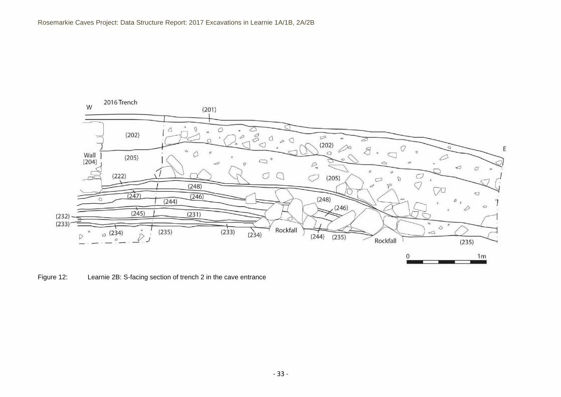
6.3 Learnie 2B 6.3.1 Through the entrance of Learnie 2B, a 2m-wide by 4m-long extension to the east side of the 2016
excavation trench was excavated to evaluate the potential for metal-working activity outside of the cave. This revealed that the deep sequence of archaeological layers identified in 2016 dissipated towards the outside of the cave (Figure 12). These layers represented material generated within the caves through time and corresponded with previous interpretations (Birch and Peteranna 2017). They contained further fire-cracked stone, charcoal and ash layers, shell, animal bone (cattle, sheep and pig) and large fish (cod, ling) bone. This area of the cave, located below the drip-line was not an ideal place to carry out activities - a number of large rocks were uncovered here that had fallen from the cliff above. Of particular note during the excavation were further finds of metalworking residues including a hearth base, three pieces of iron slag, and one fragment of vitrified furnace wall and a fragment of worked antler (SF287) from the occupation layer (232), which overlay the metal-working activity zone excavated in 2016 in the back of the cave.
6.3.2 Inside the cave, the 2016 excavation trench west edge was extended in 2017 to finish excavation of
the archaeological layers that dissipated towards the back for the cave over the rising bedrock. At the base of the archaeological sequence within a roughly-built, subrectangular setting of stones (511), the skeleton of a juvenile cow was uncovered over the natural sand and set between inclines of natural bedrock (Figures 14-15). The setting measured 1.4m long N-S and comprised angular stones. The spinal column of the calf was partially covered by the setting on the east side, while stones were placed across the limbs on the west side. As a result, the setting did not contain the animal, but rested on top of it, with two larger stones over the lower abdomen area, and smaller stones over the chest area. Strangely, the right mandible, right pelvis and cranium of the calf were missing. The bones displayed minimal evidence for butchery or intervention – in the form of a cutmark and burning on one femur as well as blue-green staining on some of the bones (Kennedy 2018). The cutmark on the femur could indicate that the missing right pelvis had been removed before the carcass was placed in the grave and that something had chemically affected the condition of the bone after the flesh had deteriorated away. The loose silt layer (510) to the outside of the burial setting and the silting fill (511) within the setting and around the calf skeleton contained late 19th century material including clay pipe stems, bottle glass, pot sherds, leather fragments, leather shoes – one of which was located below the animal’s rib cage. The loose nature of the surrounding sediment and the voids within the burial environment surrounding the skeleton, call into question whether there had been some disturbance to the burial during 19th/20th century activities in the cave. Radiocarbon dating of a bone sample from the young animal should confirm if this was the case.
6.3.3 The calf burial was located below a shallow sequence of post-medieval occupation material, at the
top of which was a slabbed hearth setting (508), situated between two ash deposits (507) and (509). It had been built to the east of the burial stone setting (511) covering the calf skeleton, using the stones on its east side as a back for the hearth (to which were added additional smaller stones to form a more circular setting on this inside of the hearth). Above the (509) layer, another hearth (514) had been constructed in the back of the cave, between two bedrock ribs on the natural sand, using a large and flat inclined slab of rock. At some stage during the use of this feature, a pit was cut through the ashy spreads to the west of it, possibly for construction of the animal burial or possibly during later disturbance. Ash from the use of the hearths had filtered down into the burial setting, and above this midden and floor deposits accumulated, completely burying the setting and hearths. A substantial amount of post-medieval artefacts was recovered from the layers overlying the hearths and burial (Figure 13), in particular from (222) and (227) – ceramic fragments, glass bottle fragments, leather shoes and offcuts, clay pipe stems and iron fragments and nails.
6.4 Learnie 2C 6.4.1 A single test pit measuring 1m square had been excavated during 2016 in Learnie 2C, located
immediately to the north of Learnie 2B. Below the modern disturbance, layers containing Victorian ceramics and iron debris (501) and (502) covered possible structural stonework and charcoal-rich ash
Rosemarkie Caves Project: Data Structure Report: 2017 Excavations in Learnie 1A/1B, 2A/2B
- 23 -
lenses. The 2017 excavation set out three trenches against the south wall of the cave, with separating control baulks (Figures 16-18).
6.4.2 The archaeological sequence inside the cave was shallow, with upper layers (301-302, 201-202, 101)
containing mostly late 19th century material including ceramic sherds, bottle grass fragments, leather offcuts and occasional personal items such as buttons and clay pipes. Interestingly, several worked horn cores (SF017) were found in Trench 3. Worked horn was also recovered from Learnie 2B and contexts (101) and (127) in Learnie 1B.
6.4.3 Trench 2 contained an upper ash layer (203), below a shallow rubble wall (204), and upper shell midden (208/209). These overlay an organic soil (205) containing shell and mammal bone and 19th century material such as ceramic sherds, clay pipes and bottle glass. Below this, an ashy silt layer containing charcoal (206) had formed over a cobbled surface (207) within the natural sand – potentially representing the earliest archaeological horizon in the cave.
6.4.4 Trench 3 contained a shallow sequence of layers, with an upper hearth or spot-fire layer (304)
overlying a compact soil (305) that contained mammal bone, iron fragments and clay pipe stems. There was no continuation in the back of the cave of the sequence of lower layers recorded in Trench 2.
6.4.5 While the results show there was likely late 19th century use of Learnie 2C, there was a limited depth
of deposits suggesting that the cave was used significantly before the post-medieval period.
7 DISCUSSION 7.1 Learnie 1A / 1B 7.1.1 In Learnie 1B, the test pit excavated in 2013 isolated contexts (108, (109), (110), (111) and (112) as a
sequence of ash and charcoal-rich layers and features. During 2017, excavations only came to the surface of (108), which indicates that the layer contains structural elements, such as a slabbed surface and/or hearth setting. The test pit results clearly demonstrate that further archaeological layers survive below this. The extensive spread of the ash layer with areas of heat-affected slabs and intense burning indicates that a major burning event, or industry associated with frequent use of fires, took place inside the cave. However, the ash did appear to be an in situ horizon. More excavation has the potential to recover material to understand the activities associated with this surface. It is possible that this occupation represents medieval or most likely early medieval use, to judge by the 8th/9th century radiocarbon dates obtained from samples of material below this. Furthermore, it is possible that the use of Learnie 1B relates to or was contemporary with the early medieval occupation in Learnie 2B – perhaps metal-working or another industry was taking place inside Learnie 1B.
7.1.2 As established in Learnie 2B in 2016, a stone infill layer had been spread across the cave, forming a levelling deposit on top of which late mid-late 19th century activity resumed. This appears to be the similar case in Learnie 1B and 1A, whether as a result of a sudden collapse of cave wall/roof and associated shatter, or as part of a preparation of a new floor after a period of abandonment. As in Learnie 2B, periods of c.19th century occupation took place in Learnie 1B and 1A associated with hearth settings and fire pits – with material culture representing elements of everyday life inside the cave. And, at the top of the sequence (as in Learnie 2B), late 19th century occupation is present with leather shoes and leather offcuts prevalent. It seems clear now, that associated with the worked horn and frequent iron fragments (including metal offcuts), that small scale industry was undertaken inside the Learnie group of caves during this period – likely representing work performed by itinerant inhabitants for local communities. It is also interesting to note that several knife handles or pen knives, cobble tools and possible bone tools have been found at these levels inside the caves.
7.1.3 Learnie 1B is the largest of the groups of caves studied and may have provided shelter for multiple or
extended families, as seen at Tinkers Cave in Wick. But there may be other stories to tell – potential
Rosemarkie Caves Project: Data Structure Report: 2017 Excavations in Learnie 1A/1B, 2A/2B
- 24 -
alternative usage of the caves other than for workshops or occupation may have included smuggling, as hideaways and livestock containment. Remains of degraded rubble walls were found inside Learnie 1B, 2B and 2C and may represent the formation of an enclosed space, partitions, or just a simple screen separating activities in the cave from the outside world. Overall, the archaeological evidence indicates that there were multiple periods of post-medieval occupation and it is likely that the use of the caves changed during those periods. Certainly, there is more of a story to tell about these post-medieval periods of occupation inside the caves. Further analysis of the large body of small finds, alongside further documentary research, should enable a clearer chronology to be built together with a greater understanding of the activities taking place.
7.2 Learnie 2B
7.2.1 The surprise discovery of the calf burial in the back of Learnie 2B, overlying the natural sand and bedrock, below later midden and hearth layers, caused speculation for the archaeologists. An unusual burial of a young cow, showing minimal butchery and deliberate placement below a stone setting, appeared to display similar characteristics to the unusual burial of Rosemarkie Man, who was also placed on the natural sand/bedrock and had associated with him a minimally butchered offering of meat from cow and horse. As it seems uncommon for 19th century occupants of the cave to sacrifice a calf instead of consuming it, the nature of the burial associated with a mixture of late 19th century artefacts are unusual. It is a possibility that the pit cutting through the upper hearth sequence was made during later activity inside the cave and perhaps unintentionally came into contact with the grave, causing disturbance to the animal’s burial conditions. This may have resulted in movement/loss of several of the calf bones include the pelvis, cranium and lower left mandible. Also, given the mobile condition of the sandy cave sediments within these lower horizons, it is possible that the 19th century finds within the burial are residual from disturbance, which could include bioturbated material. It thus remains a possibility that the burial was an early internment in the back of the cave and could be associated with early medieval activity. This should not be ruled out until radiocarbon dating of the bone is undertaken.
7.2.2 As with the results from Learnie 1B, there is an interesting story to tell about occupation of the cave by
itinerant inhabitants during the late 19th century and prior to this. The 2017 excavation in the back of the cave recovered further post-medieval occupation material. A detailed study of the artefacts will, no doubt, elucidate the evidence.
8 CONCLUSION AND RECOMMENDATIONS 8.1 The results of excavation and analysis of the finds from Learnie 2B have provided significant
information about activity inside the cave during the 1st millennium AD. In Learnie 1B (and 1A), the recent work has indicated that substantial archaeological information remains to be uncovered from potentially similar periods. More excavation in Learnie 1B/1A would undoubtedly provide more information to compare alongside the Learnie 2B results – enabling greater understanding of the overall story of their use and its relationship to the wider cultural narrative.
8.2 The results from Learnie 2B are still in the early stages of interpretation. Crucially, the work has
raised further questions about the society/culture to which this information relates. The early-late centuries of the 1st millennium overlap with an interesting history in the north of Scotland – beginning with the Picts, early Christian activity, Norse incursions and finally the early beginnings of feudalism and the monarchy. Further research and post-excavation analysis of the archaeological assemblages is vital moving forward. This will include analysis of the charcoal and animal bone assemblages, metal-working debris, small finds and further radiocarbon dating.
8.3 Results from the excavations in Learnie 2B, Learnie 1B and Learnie 1A have indicated that the caves
contain a wealth of material from post-medieval periods of activity. The activity represented by these periods of use has, in particular, provided an interesting glimpse into the 19th century occupants of
Rosemarkie Caves Project: Data Structure Report: 2017 Excavations in Learnie 1A/1B, 2A/2B
- 25 -
the Learnie caves. The artefacts and ecofacts represent everyday activities and debris left behind by potentially itinerant inhabitants – which may have been inside the caves on an almost permanent basis. This period seems to be associated with small scale industry represented by the shoe and leather finds, worked horn, iron scraps and other small finds such as the knives and cobble and bone tools. Further specialist analysis on these individual elements (leather, iron and horn) together with the everyday items and midden material will assist in building this story. Further documentary research is also highly recommended for this period. Initial research in archival material has found references to a man from a cave at Learnie regarding the burial of his wife (pers comm R Jones 2017).
9 REFERENCES
Anderson-Whymark, H 2011. Excavation at Caird’s Cave, Rosemarkie, 2010: Data Structure Report Armit, I., Schulting, R., Knusel, C.J. & Shepherd, I.A.G. 2011 ‘Death, Decapitation and Display?: The
Bronze and Iron Age Human Remains from the Sculptor’s Cave, Covesea, North-East Scotland’.
Proceedings of the Prehistoric Society 77, pp. 251-78 Birch, S. and Peteranna, M. 2017 Rosemarkie Caves Project Data Structure Report 2016 Archaeological Excavation in Learnie 2B.
Chartered Institute for Archaeologist (CIfA), 2014. By-laws of the Institute for Archaeologists: Code of Conduct. Reading: CifA Dowd, M 2015 The Archaeology of Caves in Ireland. Oxbow Books Gunn, S. and Peteranna, M. 2016 Rosemarkie Caves Project: Programme of Archaeological Survey and Test Pitting in 2011-2015.
Highland Council 2012 Standards for Archaeological Work, v.1 Http://www.highland.gov.uk/yourenvironment/conservation/archaeology/developmentguidance.htm Kennedy, K 2018 Rosemarkie Caves Project “Animal Bone Report”. Unpublished report. Wood J 2008 Community Archaeology Project, Learnie Caves 2006: Summary Report. Highland Archaeology Services, unpublished report.
Rosemarkie Caves Project: Data Structure Report: 2017 Excavations in Learnie 1A/1B, 2A/2B
- 26 -
Figure 5: Mid-excavation plan of the trench in Learnie 1B, showing hearths (117), (118) and (119) on surface (116/103) (inset: plan/section of hearth (117))
Rosemarkie Caves Project: Data Structure Report: 2017 Excavations in Learnie 1A/1B, 2A/2B
- 27 -
Figure 6: Mid-excavation plan of the trench in Learnie 1B, showing hearths (126), (128) and (130) and middens (125), (134)

Rosemarkie Caves Project: Data Structure Report: 2017 Excavations in Learnie 1A/1B, 2A/2B
- 28 -
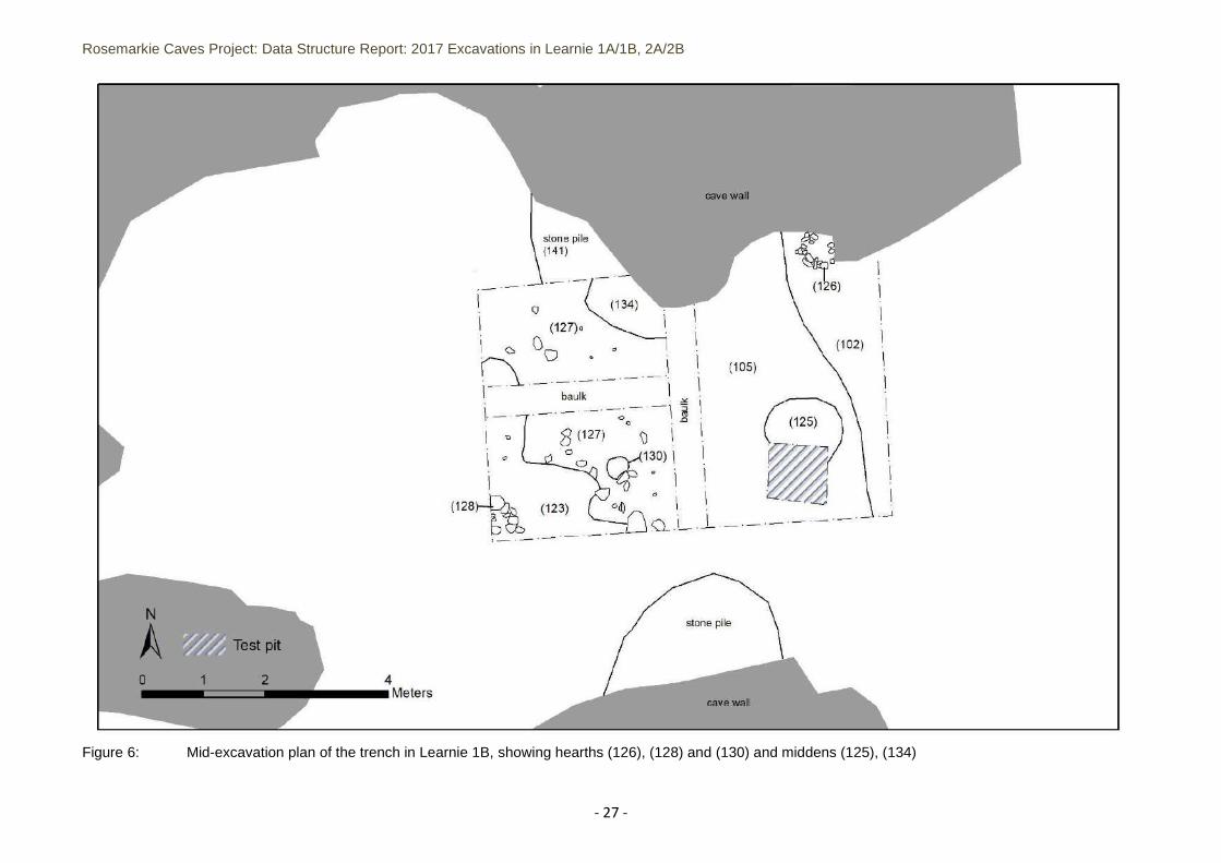
Figure 7: Post-excavation plan of the trench in Learnie 1B, showing the surface of (108) on east side of trench and (142) on west side of trench; location of section drawings
Rosemarkie Caves Project: Data Structure Report: 2017 Excavations in Learnie 1A/1B, 2A/2B
- 29 -
Figure 8: Learnie 1B section drawings: G-I, F-H and J-G and G-H, showing the sequence of archaeological deposits across the cave
Rosemarkie Caves Project: Data Structure Report: 2017 Excavations in Learnie 1A/1B, 2A/2B
- 30 -
Figure 9: Learnie 1B section drawing: B-A, A-C, D-F and C-K, showing the sequence of archaeological deposits across the cave
Rosemarkie Caves Project: Data Structure Report: 2017 Excavations in Learnie 1A/1B, 2A/2B
- 31 -
Figure 10: Post-excavation plan of Learnie 1A, showing the possible wall (306) on the west side and the base of the sub-trench to (310) in the east side of the trench
(304)
Rosemarkie Caves Project: Data Structure Report: 2017 Excavations in Learnie 1A/1B, 2A/2B
- 32 -
Figure 11: Learnie 1A: E-facing section of the central trench baulk, showing the deposits in the sub-trench on the east half of the excavation area
Rosemarkie Caves Project: Data Structure Report: 2017 Excavations in Learnie 1A/1B, 2A/2B
- 33 -
Figure 12: Learnie 2B: S-facing section of trench 2 in the cave entrance
Rosemarkie Caves Project: Data Structure Report: 2017 Excavations in Learnie 1A/1B, 2A/2B
- 34 -
Figure 13: Learnie 2B, pre-excavation plan of the western trench extension showing deposits (238) and (227) over the location of the hearth settings
Rosemarkie Caves Project: Data Structure Report: 2017 Excavations in Learnie 1A/1B, 2A/2B
- 35 -
Figure 14: Learnie 2B: pre-excavation plan of cow burial setting (511):
Rosemarkie Caves Project: Data Structure Report: 2017 Excavations in Learnie 1A/1B, 2A/2B
- 36 -
Figure 15: Learnie 2B: mid-excavation plan of cow burial setting (511)
Rosemarkie Caves Project: Data Structure Report: 2017 Excavations in Learnie 1A/1B, 2A/2B
- 37 -
Figure 16: Learnie 2C: post-excavation plan
Rosemarkie Caves Project: Data Structure Report: 2017 Excavations in Learnie 1A/1B, 2A/2B
- 38 -
Figure 17: Learnie 2C: northern baseline south facing section drawing
Rosemarkie Caves Project: Data Structure Report: 2017 Excavations in Learnie 1A/1B, 2A/2B
- 39 -
Figure 18: Learnie 2C: trench sections
Rosemarkie Caves Project: Data Structure Report: 2017 Excavations in Learnie 1A/1B, 2A/2B
- 40 -
Plate 7: Learnie 1B: hearth (117) in the west half of the excavation area, facing NW
Plate 8: Learnie 1B: leather boot (SF84) on top of bracken mat floor (103)
Rosemarkie Caves Project: Data Structure Report: 2017 Excavations in Learnie 1A/1B, 2A/2B
- 41 -
Plate 9: Learnie 1B: N- / E-facing trench sections over surface (106/107) on the east side of the excavation area; stone fill (137) to right of ranging pole and (105) in far left centre, facing SW
Plate 10: Learnie 1B: post-excavation of west side of excavation area, showing S-facing trench section in the central baulk and floor (142), facing NE
Rosemarkie Caves Project: Data Structure Report: 2017 Excavations in Learnie 1A/1B, 2A/2B
- 42 -
Plate 11: Learnie 1B: post-excavation view of the trench from the back of the cave, facing E
Plate 12: Learnie 1B: post-excavation image of east side of trench, showing the surface of (108), facing NW (test pit in centre left)
Rosemarkie Caves Project: Data Structure Report: 2017 Excavations in Learnie 1A/1B, 2A/2B
- 43 -
Plate 13: Learnie 1B: post-excavation image of trench, showing the surface of (108), facing W (test pit in front left)
Rosemarkie Caves Project: Data Structure Report: 2017 Excavations in Learnie 1A/1B, 2A/2B
- 44 -
Plate 14: SF130, articulated large mammal Plate 15: Clothes pin, SF109, from (116) vertebrae in situ within (127)
Plate 16: SF164, cobble tool w/ central wear c.138 Plate 17: SF152, worked bone tool? c.132
Plate 18: SF151, quern from c.137 Plate 19: SF174, medicine bottle from c.305
Plate 20: SF175, clay pipe “Wilson’s Cutty”, c.305 Plate 21: SF158, medieval? jug sherd from c.307
Rosemarkie Caves Project: Data Structure Report: 2017 Excavations in Learnie 1A/1B, 2A/2B
- 45 -
Plate 22: Learnie 2B: excavation through upper layers in the back of the cave, facing W
Plate 23: Learnie 2B: hearth setting (508) after removal of ash layer (507), facing W
Rosemarkie Caves Project: Data Structure Report: 2017 Excavations in Learnie 1A/1B, 2A/2B
- 46 -
Plate 24: Learnie 2B: burial setting (511), pre-excavation with calf rib bones visible, facing S
Plate 25: Learnie 2B: mid-excavation of calf burial after removal of burial setting slabs (511), facing E
Rosemarkie Caves Project: Data Structure Report: 2017 Excavations in Learnie 1A/1B, 2A/2B
- 47 -
Rosemarkie Caves Project: Data Structure Report: 2017 Excavations in Learnie 1A/1B, 2A/2B
- 48 -
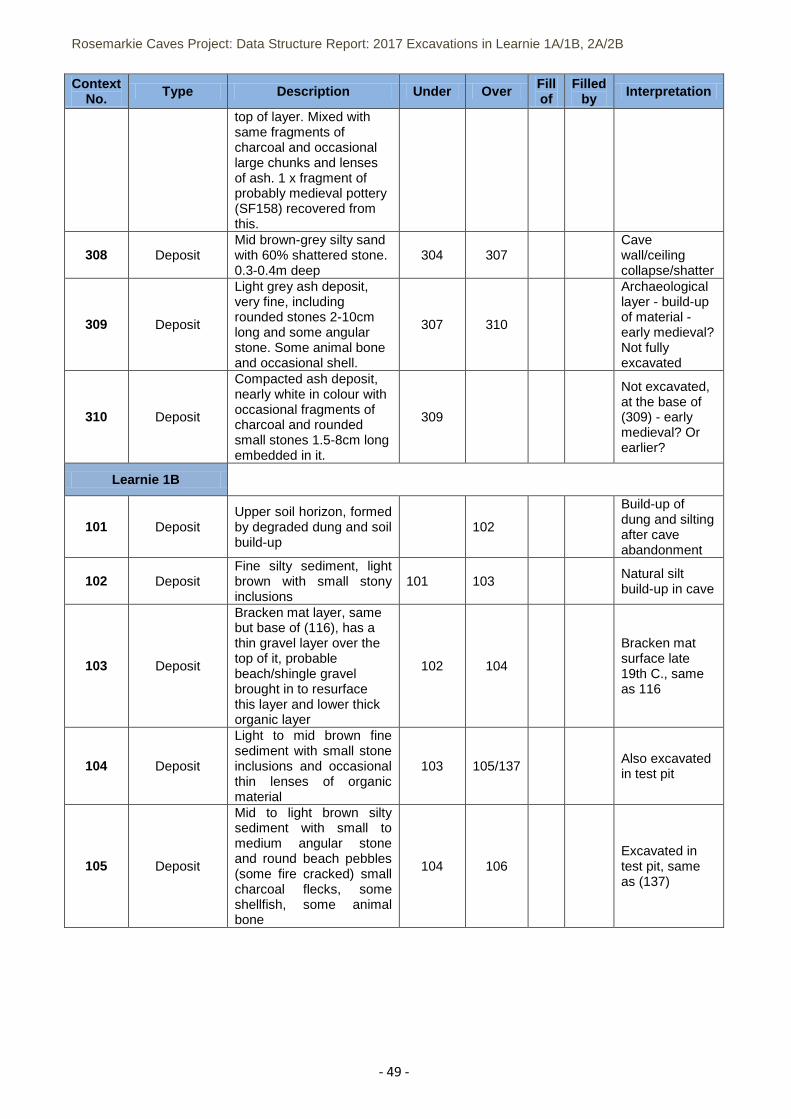
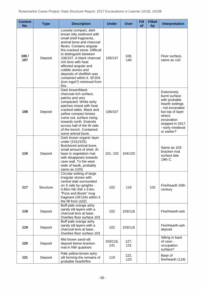
Appendix 1 List of Contexts: 2017 Excavation
Context No. Type Description Under Over Fill
of Filled
by Interpretation
Learnie 1A
300 Deposit Slightly sandy silt, upper most horizon of trench.
301 Deposit
Small ash spread, about 1mx0.8m NNE-SSW aligned. Partly covered by trench edge.
300 304
Small fire/hearth, c.late 19/20th century
302 Deposit
Matted bracken WSW of fireplace 301. Possibly a bed/mat. Degraded, 1.25mx1m. N-S aligned.
300 304
Bracken mat/floor surface c.19/20th century use
303 Structure
Mound of stone fragments below overhang of cave wall; stone is mix of angular talus and fragmentary stone, as well as some rounded beach cobbles. Abuts 306 to the south side
306 Stone clearance from cave floor
304 Deposit Mid brown sandy silt 301, 302 308
305 Deposit Grey white mottled ash 304
Thin ash lens, probably 19/20th century fire
306 Structure
Single course, subrectagular setting of fairly large angular stone, aligned ESE-WNW.
303 Low wall, rivets (303) pile of stone shatter
307 Deposit
Mid grey brown sandy silt, few small stones and some large. Rich in shellfish and ash with mainly limpet (95%), rare whelk and occasional winkle (5%) and some mammal bone mostly at
308 309 Archaeological layer - build-up or infill?
Plates 26-34:
Volunteers during the 2017 excavations
Rosemarkie Caves Project: Data Structure Report: 2017 Excavations in Learnie 1A/1B, 2A/2B
- 49 -
Context No. Type Description Under Over Fill
of Filled
by Interpretation
top of layer. Mixed with same fragments of charcoal and occasional large chunks and lenses of ash. 1 x fragment of probably medieval pottery (SF158) recovered from this.
308 Deposit Mid brown-grey silty sand with 60% shattered stone. 0.3-0.4m deep
304 307 Cave wall/ceiling collapse/shatter
309 Deposit
Light grey ash deposit, very fine, including rounded stones 2-10cm long and some angular stone. Some animal bone and occasional shell.
307 310
Archaeological layer - build-up of material - early medieval? Not fully excavated
310 Deposit
Compacted ash deposit, nearly white in colour with occasional fragments of charcoal and rounded small stones 1.5-8cm long embedded in it.
309
Not excavated, at the base of (309) - early medieval? Or earlier?
Learnie 1B
101 Deposit Upper soil horizon, formed by degraded dung and soil build-up
102
Build-up of dung and silting after cave abandonment
102 Deposit Fine silty sediment, light brown with small stony inclusions
101 103 Natural silt build-up in cave
103 Deposit
Bracken mat layer, same but base of (116), has a thin gravel layer over the top of it, probable beach/shingle gravel brought in to resurface this layer and lower thick organic layer
102 104
Bracken mat surface late 19th C., same as 116
104 Deposit
Light to mid brown fine sediment with small stone inclusions and occasional thin lenses of organic material
103 105/137 Also excavated in test pit
105 Deposit
Mid to light brown silty sediment with small to medium angular stone and round beach pebbles (some fire cracked) small charcoal flecks, some shellfish, some animal bone
104 106 Excavated in test pit, same as (137)
Rosemarkie Caves Project: Data Structure Report: 2017 Excavations in Learnie 1A/1B, 2A/2B
- 50 -
Context No. Type Description Under Over Fill
of Filled
by Interpretation
106 / 107 Deposit
Loosely compact, dark brown silty sediment with small shell fragments, animal bone and charcoal flecks. Contains angular fire-cracked stone. Difficult to distinguish between 106/107. A black charcoal rich lens with heat affected angular and cobble stones and deposits of shellfish was contained within it. SF204 (iron ingot?) retrieved from this.
105/137 108, 140
Floor surface, same as 142
108 Deposit
Dark brown/black charcoal-rich surface, patchy and very compacted. White ashy patches mixed with heat cracked slabs. Black and yellow compact lenses come out, surface rising towards north. Extends across half of the W side of the trench. Contained some animal bone.
106/107
Extensively burnt surface with probable hearth settings - not excavated but top of layer where excavation stopped in 2017 - early medieval or earlier?
116 Deposit
Dark brown organic layer under (101)/102). Butchered animal bone, small amount of shell. At base is vegetation mat with disappears towards cave wall. To the west wide of baulk, probably same as (103)
101, 102 104/120
Same as 103-bracken mat surface late 19th C.
117 Structure
Circular setting of large irregular stones with central slab surrounded on S side by uprights - 0.85m NE-SW x 0.6m. "Puss and Boots" mug fragment (SF154) within it the fill from (102)
102 116 102 Fire/hearth 20th century
118 Deposit
Buff-pale orange ashy sandy silt layers with a charcoal lens at base. Overlies floor surface 103
102 103/116 Fire/Hearth-ash
119 Deposit
Buff-pale orange ashy sandy silt layers with a charcoal lens at base. Overlies floor surface 103
102 103/116 Fire/Hearth-ash deposit
120 Deposit Mid brown sand-silt deposit below bracken mat in NW quadrant
103/116, 141
127, 131
Silting in back of cave - occupation surface?
121 Deposit Pale yellow-brown ashy silt forming the remains of probable hearth/fire
119 122, 123
Base of fire/hearth (119)
Rosemarkie Caves Project: Data Structure Report: 2017 Excavations in Learnie 1A/1B, 2A/2B
- 51 -
Context No. Type Description Under Over Fill
of Filled
by Interpretation
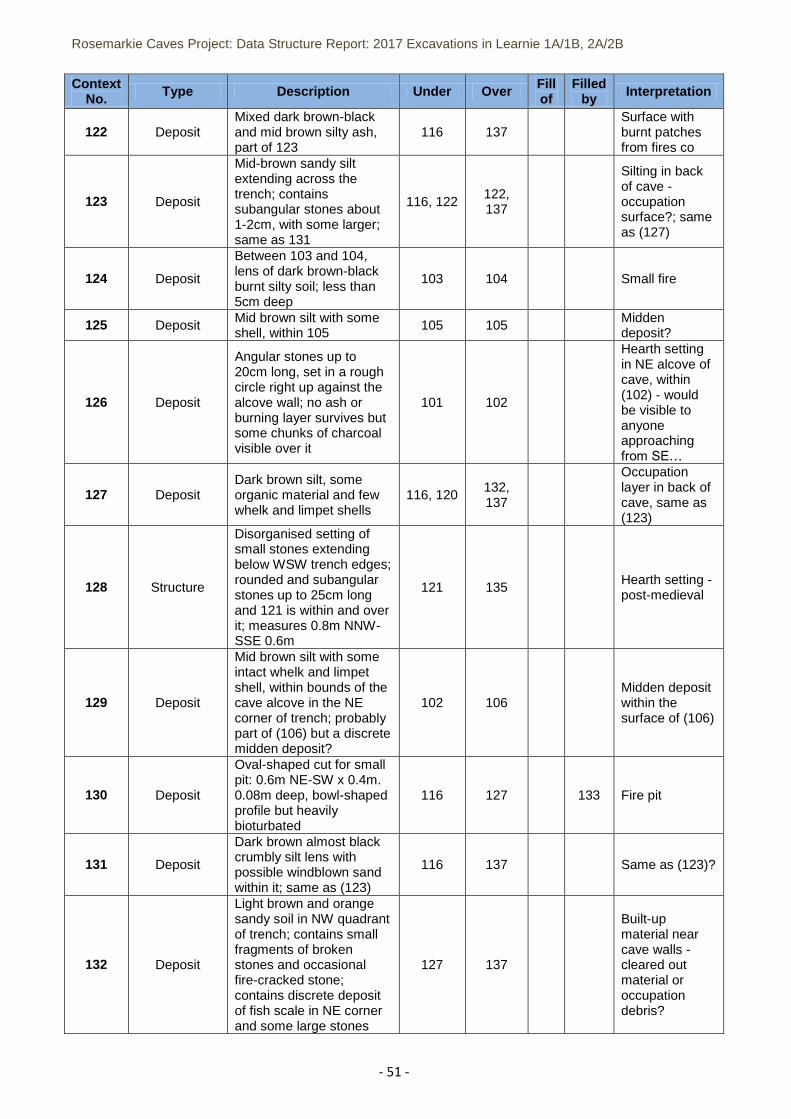
122 Deposit Mixed dark brown-black and mid brown silty ash, part of 123
116 137 Surface with burnt patches from fires co
123 Deposit
Mid-brown sandy silt extending across the trench; contains subangular stones about 1-2cm, with some larger; same as 131
116, 122 122, 137
Silting in back of cave - occupation surface?; same as (127)
124 Deposit
Between 103 and 104, lens of dark brown-black burnt silty soil; less than 5cm deep
103 104 Small fire
125 Deposit Mid brown silt with some shell, within 105
105 105 Midden deposit?
126 Deposit
Angular stones up to 20cm long, set in a rough circle right up against the alcove wall; no ash or burning layer survives but some chunks of charcoal visible over it
101 102
Hearth setting in NE alcove of cave, within (102) - would be visible to anyone approaching from SE…
127 Deposit Dark brown silt, some organic material and few whelk and limpet shells
116, 120 132, 137
Occupation layer in back of cave, same as (123)
128 Structure
Disorganised setting of small stones extending below WSW trench edges; rounded and subangular stones up to 25cm long and 121 is within and over it; measures 0.8m NNW-SSE 0.6m
121 135 Hearth setting - post-medieval
129 Deposit
Mid brown silt with some intact whelk and limpet shell, within bounds of the cave alcove in the NE corner of trench; probably part of (106) but a discrete midden deposit?
102 106 Midden deposit within the surface of (106)
130 Deposit
Oval-shaped cut for small pit: 0.6m NE-SW x 0.4m. 0.08m deep, bowl-shaped profile but heavily bioturbated
116 127 133 Fire pit
131 Deposit
Dark brown almost black crumbly silt lens with possible windblown sand within it; same as (123)
116 137 Same as (123)?
132 Deposit
Light brown and orange sandy soil in NW quadrant of trench; contains small fragments of broken stones and occasional fire-cracked stone; contains discrete deposit of fish scale in NE corner and some large stones
127 137
Built-up material near cave walls - cleared out material or occupation debris?
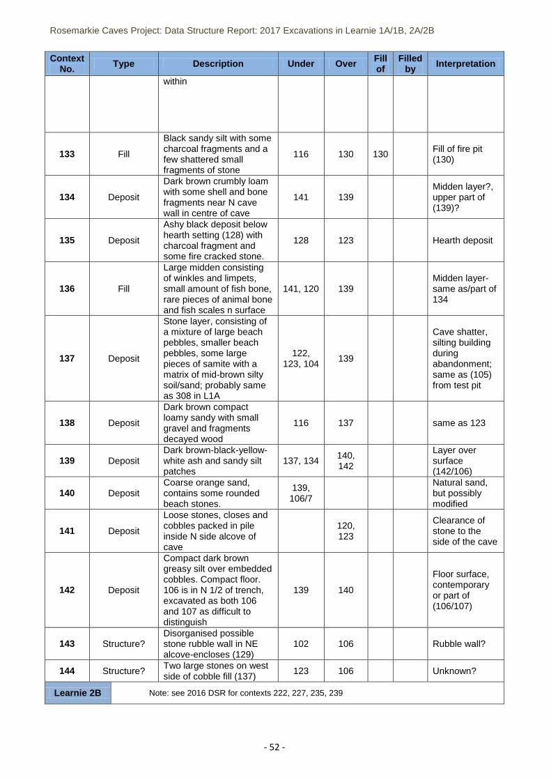
Rosemarkie Caves Project: Data Structure Report: 2017 Excavations in Learnie 1A/1B, 2A/2B
- 52 -
Context No. Type Description Under Over Fill
of Filled
by Interpretation
within
133 Fill
Black sandy silt with some charcoal fragments and a few shattered small fragments of stone
116 130 130 Fill of fire pit (130)
134 Deposit
Dark brown crumbly loam with some shell and bone fragments near N cave wall in centre of cave
141 139 Midden layer?, upper part of (139)?
135 Deposit
Ashy black deposit below hearth setting (128) with charcoal fragment and some fire cracked stone.
128 123 Hearth deposit
136 Fill
Large midden consisting of winkles and limpets, small amount of fish bone, rare pieces of animal bone and fish scales n surface
141, 120 139 Midden layer- same as/part of 134
137 Deposit
Stone layer, consisting of a mixture of large beach pebbles, smaller beach pebbles, some large pieces of samite with a matrix of mid-brown silty soil/sand; probably same as 308 in L1A
122, 123, 104
139
Cave shatter, silting building during abandonment; same as (105) from test pit
138 Deposit
Dark brown compact loamy sandy with small gravel and fragments decayed wood
116 137 same as 123
139 Deposit Dark brown-black-yellow-white ash and sandy silt patches
137, 134 140, 142
Layer over surface (142/106)
140 Deposit Coarse orange sand, contains some rounded beach stones.
139, 106/7
Natural sand, but possibly modified
141 Deposit
Loose stones, closes and cobbles packed in pile inside N side alcove of cave
120, 123
Clearance of stone to the side of the cave
142 Deposit
Compact dark brown greasy silt over embedded cobbles. Compact floor. 106 is in N 1/2 of trench, excavated as both 106 and 107 as difficult to distinguish
139 140
Floor surface, contemporary or part of (106/107)
143 Structure? Disorganised possible stone rubble wall in NE alcove-encloses (129)
102 106 Rubble wall?
144 Structure? Two large stones on west side of cobble fill (137)
123 106 Unknown?
Learnie 2B Note: see 2016 DSR for contexts 222, 227, 235, 239
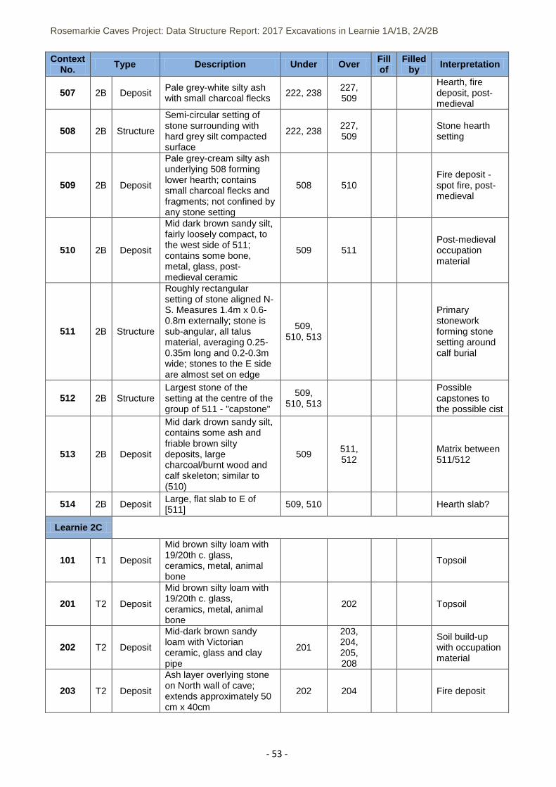
Rosemarkie Caves Project: Data Structure Report: 2017 Excavations in Learnie 1A/1B, 2A/2B
- 53 -
Context No. Type Description Under Over Fill
of Filled
by Interpretation
507 2B Deposit Pale grey-white silty ash with small charcoal flecks
222, 238 227, 509
Hearth, fire deposit, post-medieval
508 2B Structure
Semi-circular setting of stone surrounding with hard grey silt compacted surface
222, 238 227, 509
Stone hearth setting
509 2B Deposit
Pale grey-cream silty ash underlying 508 forming lower hearth; contains small charcoal flecks and fragments; not confined by any stone setting
508 510 Fire deposit - spot fire, post-medieval
510 2B Deposit
Mid dark brown sandy silt, fairly loosely compact, to the west side of 511; contains some bone, metal, glass, post-medieval ceramic
509 511 Post-medieval occupation material
511 2B Structure
Roughly rectangular setting of stone aligned N-S. Measures 1.4m x 0.6-0.8m externally; stone is sub-angular, all talus material, averaging 0.25-0.35m long and 0.2-0.3m wide; stones to the E side are almost set on edge
509, 510, 513
Primary stonework forming stone setting around calf burial
512 2B Structure Largest stone of the setting at the centre of the group of 511 - "capstone"
509, 510, 513
Possible capstones to the possible cist
513 2B Deposit
Mid dark drown sandy silt, contains some ash and friable brown silty deposits, large charcoal/burnt wood and calf skeleton; similar to (510)
509 511, 512
Matrix between 511/512
514 2B Deposit Large, flat slab to E of [511]
509, 510 Hearth slab?
Learnie 2C
101 T1 Deposit
Mid brown silty loam with 19/20th c. glass, ceramics, metal, animal bone
Topsoil
201 T2 Deposit
Mid brown silty loam with 19/20th c. glass, ceramics, metal, animal bone
202 Topsoil
202 T2 Deposit
Mid-dark brown sandy loam with Victorian ceramic, glass and clay pipe
201
203, 204, 205, 208
Soil build-up with occupation material
203 T2 Deposit
Ash layer overlying stone on North wall of cave; extends approximately 50 cm x 40cm
202 204 Fire deposit
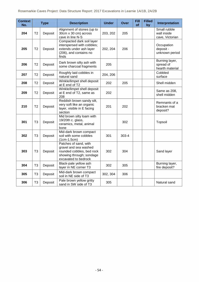
Rosemarkie Caves Project: Data Structure Report: 2017 Excavations in Learnie 1A/1B, 2A/2B
- 54 -
Context No. Type Description Under Over Fill
of Filled
by Interpretation
204 T2 Deposit Alignment of stones (up to 30cm x 30 cm) across cave in line N-S
203, 202 205 Small rubble wall inside cave, Victorian
205 T2 Deposit
Compacted dark soil layer interspersed with cobbles; extends under ash layer (206), and contains no finds
202, 204 206 Occupation deposit - unknown period
206 T2 Deposit Dark brown silty ash with some charcoal fragments
205 Burning layer, spread of hearth material
207 T2 Deposit Roughly laid cobbles in natural sand
204, 206 Cobbled surface
208 T2 Deposit Winkle/limpet shell deposit at E end of T2
202 205 Shell midden
209 T2 Deposit Winkle/limpet shell deposit at E end of T2, same as 208
202 Same as 208, shell midden
210 T2 Deposit
Reddish brown sandy silt, very soft like an organic layer, visible in E facing section
201 202 Remnants of a bracken mat deposit?
301 T3 Deposit
Mid brown silty loam with 19/20th c. glass, ceramics, metal, animal bone
302 Topsoil
302 T3 Deposit Mid-dark brown compact soil with some cobbles (1cm-1.5cm)
301 303-4
303 T3 Deposit
Patches of sand, with gravel and sea washed rounded cobbles, bed rock showing through; sondage excavated to bedrock
302 304 Sand layer
304 T3 Deposit Black-pale yellow ash layer in NE corner T3
302 305 Burning layer, fire deposit?
305 T3 Deposit Mid-dark brown compact soil in NE side of T3
302, 304 306
306 T3 Deposit Pale brown yellow gritty sand in SW side of T3
305 Natural sand
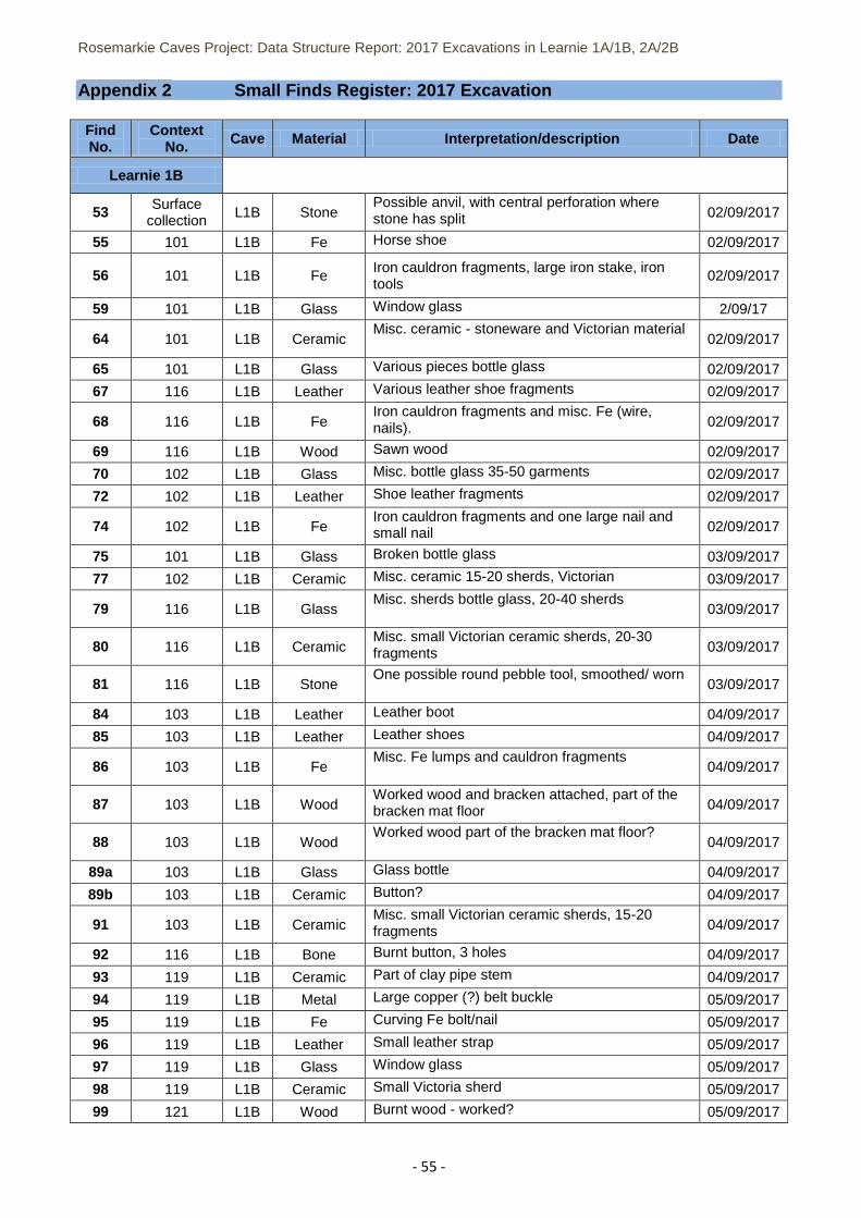
Rosemarkie Caves Project: Data Structure Report: 2017 Excavations in Learnie 1A/1B, 2A/2B
- 55 -
Appendix 2 Small Finds Register: 2017 Excavation
Find No.
Context No. Cave Material Interpretation/description Date
Learnie 1B
53 Surface collection L1B Stone
Possible anvil, with central perforation where stone has split 02/09/2017
55 101 L1B Fe Horse shoe 02/09/2017
56 101 L1B Fe Iron cauldron fragments, large iron stake, iron tools
02/09/2017
59 101 L1B Glass Window glass 2/09/17
64 101 L1B Ceramic Misc. ceramic - stoneware and Victorian material
02/09/2017
65 101 L1B Glass Various pieces bottle glass 02/09/2017
67 116 L1B Leather Various leather shoe fragments 02/09/2017
68 116 L1B Fe Iron cauldron fragments and misc. Fe (wire, nails). 02/09/2017
69 116 L1B Wood Sawn wood 02/09/2017
70 102 L1B Glass Misc. bottle glass 35-50 garments 02/09/2017
72 102 L1B Leather Shoe leather fragments 02/09/2017
74 102 L1B Fe Iron cauldron fragments and one large nail and small nail 02/09/2017
75 101 L1B Glass Broken bottle glass 03/09/2017
77 102 L1B Ceramic Misc. ceramic 15-20 sherds, Victorian 03/09/2017
79 116 L1B Glass Misc. sherds bottle glass, 20-40 sherds
03/09/2017
80 116 L1B Ceramic Misc. small Victorian ceramic sherds, 20-30 fragments 03/09/2017
81 116 L1B Stone One possible round pebble tool, smoothed/ worn
03/09/2017
84 103 L1B Leather Leather boot 04/09/2017
85 103 L1B Leather Leather shoes 04/09/2017
86 103 L1B Fe Misc. Fe lumps and cauldron fragments
04/09/2017
87 103 L1B Wood Worked wood and bracken attached, part of the bracken mat floor 04/09/2017
88 103 L1B Wood Worked wood part of the bracken mat floor?
04/09/2017
89a 103 L1B Glass Glass bottle 04/09/2017
89b 103 L1B Ceramic Button? 04/09/2017
91 103 L1B Ceramic Misc. small Victorian ceramic sherds, 15-20 fragments 04/09/2017
92 116 L1B Bone Burnt button, 3 holes 04/09/2017
93 119 L1B Ceramic Part of clay pipe stem 04/09/2017
94 119 L1B Metal Large copper (?) belt buckle 05/09/2017
95 119 L1B Fe Curving Fe bolt/nail 05/09/2017
96 119 L1B Leather Small leather strap 05/09/2017
97 119 L1B Glass Window glass 05/09/2017
98 119 L1B Ceramic Small Victoria sherd 05/09/2017
99 121 L1B Wood Burnt wood - worked? 05/09/2017
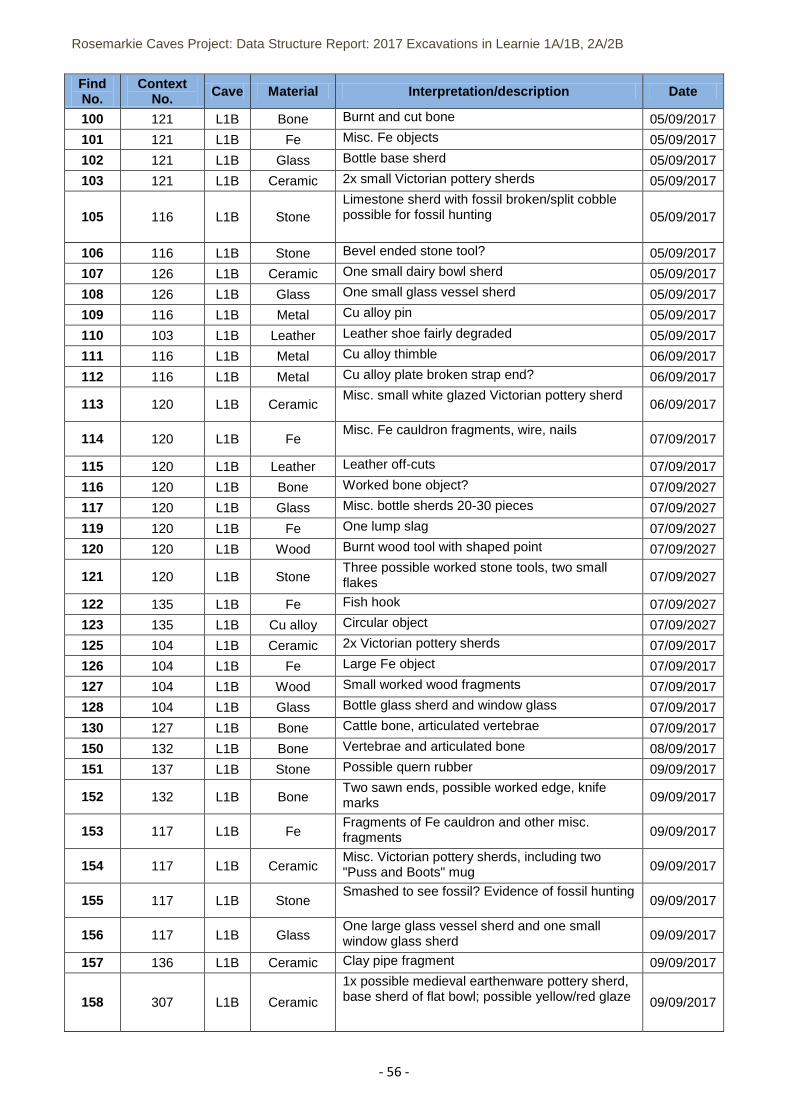
Rosemarkie Caves Project: Data Structure Report: 2017 Excavations in Learnie 1A/1B, 2A/2B
- 56 -
Find No.
Context No. Cave Material Interpretation/description Date
100 121 L1B Bone Burnt and cut bone 05/09/2017
101 121 L1B Fe Misc. Fe objects 05/09/2017
102 121 L1B Glass Bottle base sherd 05/09/2017
103 121 L1B Ceramic 2x small Victorian pottery sherds 05/09/2017
105 116 L1B Stone Limestone sherd with fossil broken/split cobble possible for fossil hunting 05/09/2017
106 116 L1B Stone Bevel ended stone tool? 05/09/2017
107 126 L1B Ceramic One small dairy bowl sherd 05/09/2017
108 126 L1B Glass One small glass vessel sherd 05/09/2017
109 116 L1B Metal Cu alloy pin 05/09/2017
110 103 L1B Leather Leather shoe fairly degraded 05/09/2017
111 116 L1B Metal Cu alloy thimble 06/09/2017
112 116 L1B Metal Cu alloy plate broken strap end? 06/09/2017
113 120 L1B Ceramic Misc. small white glazed Victorian pottery sherd
06/09/2017
114 120 L1B Fe Misc. Fe cauldron fragments, wire, nails
07/09/2017
115 120 L1B Leather Leather off-cuts 07/09/2017
116 120 L1B Bone Worked bone object? 07/09/2027
117 120 L1B Glass Misc. bottle sherds 20-30 pieces 07/09/2027
119 120 L1B Fe One lump slag 07/09/2027
120 120 L1B Wood Burnt wood tool with shaped point 07/09/2027
121 120 L1B Stone Three possible worked stone tools, two small flakes 07/09/2027
122 135 L1B Fe Fish hook 07/09/2027
123 135 L1B Cu alloy Circular object 07/09/2027
125 104 L1B Ceramic 2x Victorian pottery sherds 07/09/2017
126 104 L1B Fe Large Fe object 07/09/2017
127 104 L1B Wood Small worked wood fragments 07/09/2017
128 104 L1B Glass Bottle glass sherd and window glass 07/09/2017
130 127 L1B Bone Cattle bone, articulated vertebrae 07/09/2017
150 132 L1B Bone Vertebrae and articulated bone 08/09/2017
151 137 L1B Stone Possible quern rubber 09/09/2017
152 132 L1B Bone Two sawn ends, possible worked edge, knife marks 09/09/2017
153 117 L1B Fe Fragments of Fe cauldron and other misc. fragments 09/09/2017
154 117 L1B Ceramic Misc. Victorian pottery sherds, including two "Puss and Boots" mug 09/09/2017
155 117 L1B Stone Smashed to see fossil? Evidence of fossil hunting
09/09/2017
156 117 L1B Glass One large glass vessel sherd and one small window glass sherd 09/09/2017
157 136 L1B Ceramic Clay pipe fragment 09/09/2017
158 307 L1B Ceramic
1x possible medieval earthenware pottery sherd, base sherd of flat bowl; possible yellow/red glaze 09/09/2017
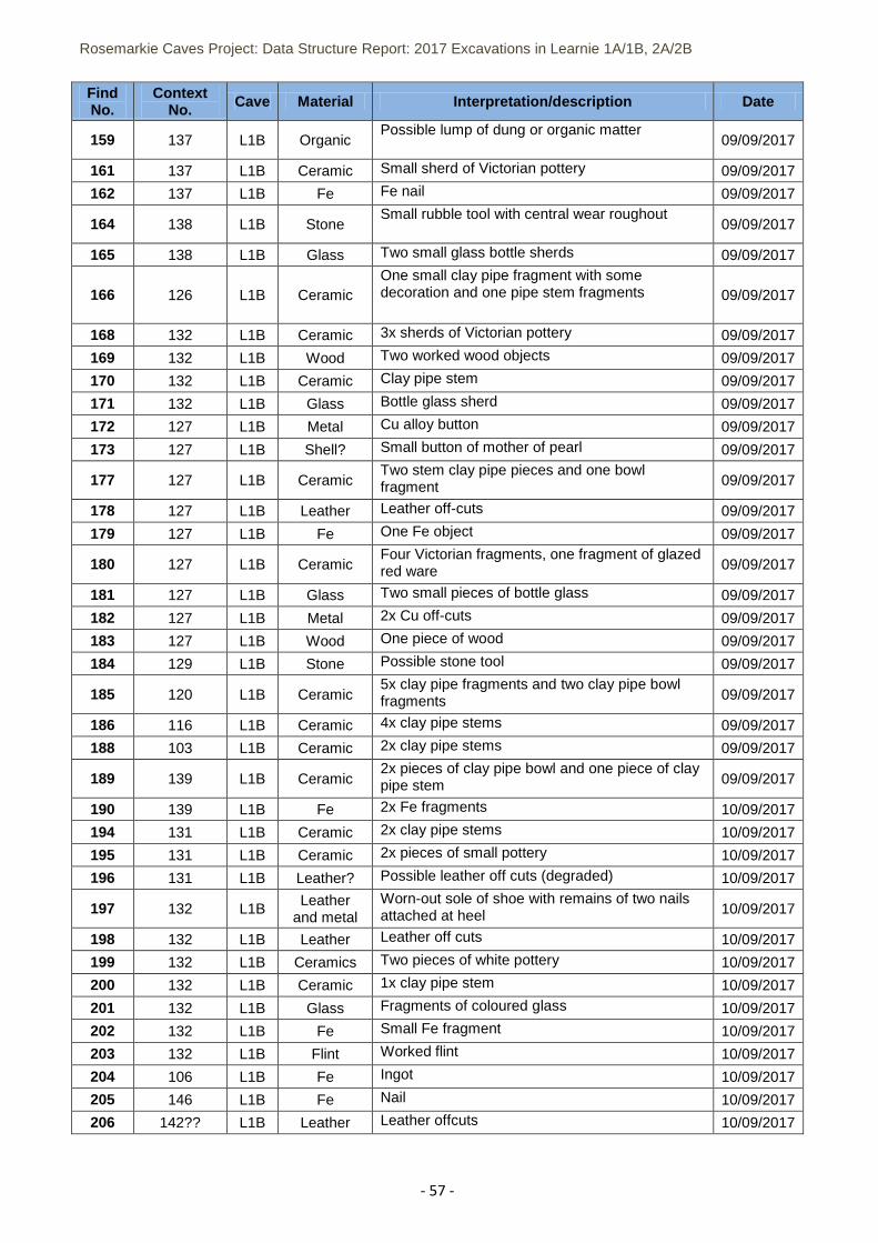
Rosemarkie Caves Project: Data Structure Report: 2017 Excavations in Learnie 1A/1B, 2A/2B
- 57 -
Find No.
Context No. Cave Material Interpretation/description Date
159 137 L1B Organic Possible lump of dung or organic matter
09/09/2017
161 137 L1B Ceramic Small sherd of Victorian pottery 09/09/2017
162 137 L1B Fe Fe nail 09/09/2017
164 138 L1B Stone Small rubble tool with central wear roughout
09/09/2017
165 138 L1B Glass Two small glass bottle sherds 09/09/2017
166 126 L1B Ceramic One small clay pipe fragment with some decoration and one pipe stem fragments 09/09/2017
168 132 L1B Ceramic 3x sherds of Victorian pottery 09/09/2017
169 132 L1B Wood Two worked wood objects 09/09/2017
170 132 L1B Ceramic Clay pipe stem 09/09/2017
171 132 L1B Glass Bottle glass sherd 09/09/2017
172 127 L1B Metal Cu alloy button 09/09/2017
173 127 L1B Shell? Small button of mother of pearl 09/09/2017
177 127 L1B Ceramic Two stem clay pipe pieces and one bowl fragment 09/09/2017
178 127 L1B Leather Leather off-cuts 09/09/2017
179 127 L1B Fe One Fe object 09/09/2017
180 127 L1B Ceramic Four Victorian fragments, one fragment of glazed red ware 09/09/2017
181 127 L1B Glass Two small pieces of bottle glass 09/09/2017
182 127 L1B Metal 2x Cu off-cuts 09/09/2017
183 127 L1B Wood One piece of wood 09/09/2017
184 129 L1B Stone Possible stone tool 09/09/2017
185 120 L1B Ceramic 5x clay pipe fragments and two clay pipe bowl fragments 09/09/2017
186 116 L1B Ceramic 4x clay pipe stems 09/09/2017
188 103 L1B Ceramic 2x clay pipe stems 09/09/2017
189 139 L1B Ceramic 2x pieces of clay pipe bowl and one piece of clay pipe stem 09/09/2017
190 139 L1B Fe 2x Fe fragments 10/09/2017
194 131 L1B Ceramic 2x clay pipe stems 10/09/2017
195 131 L1B Ceramic 2x pieces of small pottery 10/09/2017
196 131 L1B Leather? Possible leather off cuts (degraded) 10/09/2017
197 132 L1B Leather
and metal Worn-out sole of shoe with remains of two nails attached at heel 10/09/2017
198 132 L1B Leather Leather off cuts 10/09/2017
199 132 L1B Ceramics Two pieces of white pottery 10/09/2017
200 132 L1B Ceramic 1x clay pipe stem 10/09/2017
201 132 L1B Glass Fragments of coloured glass 10/09/2017
202 132 L1B Fe Small Fe fragment 10/09/2017
203 132 L1B Flint Worked flint 10/09/2017
204 106 L1B Fe Ingot 10/09/2017
205 146 L1B Fe Nail 10/09/2017
206 142?? L1B Leather Leather offcuts 10/09/2017
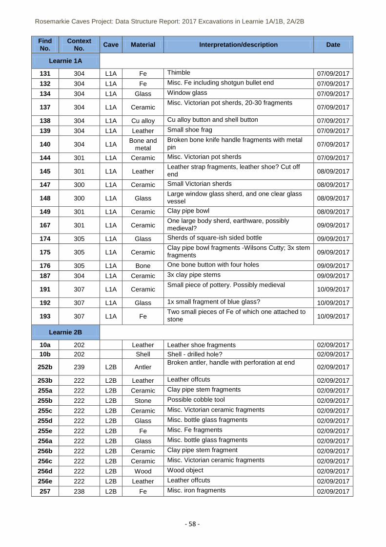
Rosemarkie Caves Project: Data Structure Report: 2017 Excavations in Learnie 1A/1B, 2A/2B
- 58 -
Find No.
Context No. Cave Material Interpretation/description Date
Learnie 1A
131 304 L1A Fe Thimble 07/09/2017
132 304 L1A Fe Misc. Fe including shotgun bullet end 07/09/2017
134 304 L1A Glass Window glass 07/09/2017
137 304 L1A Ceramic Misc. Victorian pot sherds, 20-30 fragments
07/09/2017
138 304 L1A Cu alloy Cu alloy button and shell button 07/09/2017
139 304 L1A Leather Small shoe frag 07/09/2017
140 304 L1A Bone and
metal Broken bone knife handle fragments with metal pin 07/09/2017
144 301 L1A Ceramic Misc. Victorian pot sherds 07/09/2017
145 301 L1A Leather Leather strap fragments, leather shoe? Cut off end 08/09/2017
147 300 L1A Ceramic Small Victorian sherds 08/09/2017
148 300 L1A Glass Large window glass sherd, and one clear glass vessel 08/09/2017
149 301 L1A Ceramic Clay pipe bowl 08/09/2017
167 301 L1A Ceramic One large body sherd, earthware, possibly medieval? 09/09/2017
174 305 L1A Glass Sherds of square-ish sided bottle 09/09/2017
175 305 L1A Ceramic Clay pipe bowl fragments -Wilsons Cutty; 3x stem fragments 09/09/2017
176 305 L1A Bone One bone button with four holes 09/09/2017
187 304 L1A Ceramic 3x clay pipe stems 09/09/2017
191 307 L1A Ceramic Small piece of pottery. Possibly medieval
10/09/2017
192 307 L1A Glass 1x small fragment of blue glass? 10/09/2017
193 307 L1A Fe Two small pieces of Fe of which one attached to stone 10/09/2017
Learnie 2B
10a 202 Leather Leather shoe fragments 02/09/2017 10b 202 Shell Shell - drilled hole? 02/09/2017
252b 239 L2B Antler Broken antler, handle with perforation at end
02/09/2017
253b 222 L2B Leather Leather offcuts 02/09/2017
255a 222 L2B Ceramic Clay pipe stem fragments 02/09/2017
255b 222 L2B Stone Possible cobble tool 02/09/2017
255c 222 L2B Ceramic Misc. Victorian ceramic fragments 02/09/2017
255d 222 L2B Glass Misc. bottle glass fragments 02/09/2017
255e 222 L2B Fe Misc. Fe fragments 02/09/2017
256a 222 L2B Glass Misc. bottle glass fragments 02/09/2017
256b 222 L2B Ceramic Clay pipe stem fragment 02/09/2017
256c 222 L2B Ceramic Misc. Victorian ceramic fragments 02/09/2017
256d 222 L2B Wood Wood object 02/09/2017
256e 222 L2B Leather Leather offcuts 02/09/2017
257 238 L2B Fe Misc. iron fragments 02/09/2017
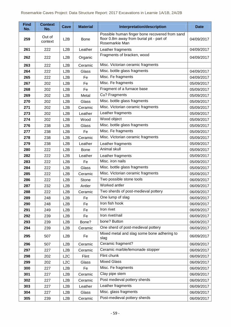
Rosemarkie Caves Project: Data Structure Report: 2017 Excavations in Learnie 1A/1B, 2A/2B
- 59 -
Find No.
Context No. Cave Material Interpretation/description Date
259 Out of context
L2B Bone Possible human finger bone recovered from sand floor 0.8m away from burial pit - part of Rosemarkie Man
04/09/2017
261 222 L2B Leather Leather fragments 04/09/2017
262 222 L2B Organic Fragments of bracken, wood
04/09/2017
263 222 L2B Ceramic Misc. Victorian ceramic fragments
264 222 L2B Glass Misc. bottle glass fragments 04/09/2017
265 222 L2B Fe Misc. Fe fragments 04/09/2017
267 202 L2B Fe Misc. Fe fragments 05/09/2017
268 202 L2B Fe Fragment of a furnace base 05/09/2017
269 202 L2B Metal Cu? Fragments 05/09/2017
270 202 L2B Glass Misc. bottle glass fragments 05/09/2017
271 202 L2B Ceramic Misc. Victorian ceramic fragments 05/09/2017
273 202 L2B Leather Leather fragments 05/09/2017
274 202 L2B Wood Wood object 05/09/2017
276 238 L2B Glass Misc. bottle glass fragments 05/09/2017
277 238 L2B Fe Misc. Fe fragments 05/09/2017
278 238 L2B Ceramic Misc. Victorian ceramic fragments 05/09/2017
279 238 L2B Leather Leather fragments 05/09/2017
280 222 L2B Bone Animal skull 05/09/2017
282 222 L2B Leather Leather fragments 05/09/2017
283 222 L2B Fe Misc. iron nails 05/09/2017
284 222 L2B Glass Misc. bottle glass fragments 05/09/2017
285 222 L2B Ceramic Misc. Victorian ceramic fragments 05/09/2017
286 222 L2B Stone Two possible stone tools 06/09/2017
287 232 L2B Antler Worked antler 06/09/2017
288 222 L2B Ceramic Two sherds of post-medieval pottery 06/09/2017
289 248 L2B Fe One lump of slag 06/09/2017
290 248 L2B Fe Iron fish hook 06/09/2017
291 249 L2B Fe Iron rivet 06/09/2017
292 239 L2B Fe Iron rivet/nail 06/09/2017
293 239 L2B Bone? bone? Button 06/09/2017
294 239 L2B Ceramic One sherd of post-medieval pottery 06/09/2017
295 507 L2B Fe Mixed metal and slag some bone adhering to slag 06/09/2017
296 507 L2B Ceramic Ceramic fragment? 06/09/2017
297 227 L2B Ceramic Ceramic marble/lemonade stopper 06/09/2017
298 202 L2C Flint Flint chunk 06/09/2017
299 202 L2C Glass Mixed Glass 06/09/2017
300 227 L2B Fe Misc. Fe fragments 06/09/2017
301 227 L2B Ceramic Clay pipe stem 06/09/2017
302 227 L2B Ceramic Post medieval pottery sherds 06/09/2017
303 227 L2B Leather Leather fragments 06/09/2017
304 227 L2B Glass Misc. glass fragments 06/09/2017
305 239 L2B Ceramic Post-medieval pottery sherds 06/09/2017
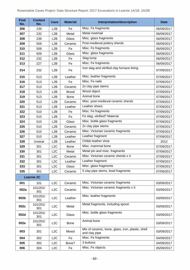
Rosemarkie Caves Project: Data Structure Report: 2017 Excavations in Learnie 1A/1B, 2A/2B
- 60 -
Find No.
Context No. Cave Material Interpretation/description Date
306 239 L2B Fe Misc. Fe fragments 06/09/2017
307 232 L2B Metal Metal rivet/nail 06/09/2017
308 239 L2B Glass Misc. glass fragments 06/09/2017
309 509 L2B Ceramic Post-medieval pottery sherds 06/09/2017
310 509 L2B Fe Misc. Fe fragments 06/09/2017
311 509 L2B Glass Misc. glass fragments 06/09/2017
312 232 L2B Fe Slag lump 06/09/2017
313 227 L2B Fe Misc. Fe fragments 06/09/2017
314 232 L2B Fe Iron slag and vitrified clay furnace lining
07/09/2017
315 513 L2B Leather Misc. leather fragments 07/09/2017
316 513 L2B Fe Misc. Fe nails 07/09/2017
317 513 L2B Ceramic 2x clay pipe stems 07/09/2017
318 513 L2B Wood Wood object 07/09/2017
319 513 L2B Bone Animal bone 07/09/2017
320 513 L2B Ceramic Misc. post-medieval ceramic sherds 07/09/2017
321 513 L2B Leather Leather shoes 07/09/2017
322 510 L2B Fe Misc. Fe fragments 07/09/2017
323 510 L2B Fe Fe slag, vitrified? Material 07/09/2017
324 510 L2B Glass Misc. bottle glass fragments 07/09/2017
325 510 L2B Ceramic 2x clay pipe stems 07/09/2017
326 510 L2B Ceramic Misc. Victorian ceramic fragments 07/09/2017
327 510 L2B Leather Leather fragment 07/09/2017
328 Unstrat L2B Leather Childs leather shoe 2012
329 301 L2C Bone Misc. mammal bone 07/09/2017
330 301 L2C Metal Metal pin and misc. fragments 07/09/2017
331 301 L2C Ceramic Misc. Victorian ceramic sherds x 4 07/09/2017
332 301 L2C Leather Leather fragment 07/09/2017
333 301 L2C Glass Misc. glass fragments 07/09/2017
335 301 L2C Ceramic 5 clay pipe stems, bowl fragments 07/09/2017
Learnie 2C
001 101 L2C Ceramic Misc. Victorian ceramic fragments 03/09/2017
002a 101/201/ 301
L2C Ceramic Misc. Victorian ceramic fragments x 5
03/09/2017
002b 101/201/ 301
L2C Leather Misc. leather fragments
03/09/2017
002c 101/201/ 301
L2C Metal Metal fragments, including spoon
03/09/2017
002d 101/201/ 301
L2C Glass Misc. bottle glass fragments
03/09/2017
002e 101/201/ 301
L2C Bone Animal bone
03/09/2017
003 301 L2C Mixed Mix of ceramic, bone, glass, iron, plastic, shell and clay pipe 03/09/2017
004 302 L2C Fe Misc. Fe fragments 04/09/2017
005 302 L2C Bone? 3 buttons 04/09/2017
006 304 L2C Fe Misc. Fe objects 05/09/2017
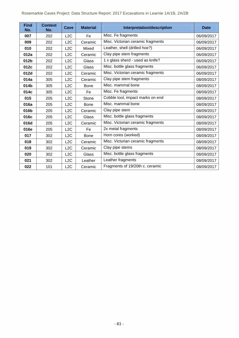
Rosemarkie Caves Project: Data Structure Report: 2017 Excavations in Learnie 1A/1B, 2A/2B
- 61 -
Find No.
Context No. Cave Material Interpretation/description Date
007 202 L2C Fe Misc. Fe fragments 06/09/2017
009 202 L2C Ceramic Misc. Victorian ceramic fragments 06/09/2017
010 202 L2C Mixed Leather, shell (drilled hoe?) 06/09/2017
012a 202 L2C Ceramic Clay pipe stem fragments 06/09/2017
012b 202 L2C Glass 1 x glass sherd - used as knife? 06/09/2017
012c 202 L2C Glass Misc. bottle glass fragments 06/09/2017
012d 202 L2C Ceramic Misc. Victorian ceramic fragments 06/09/2017
014a 305 L2C Ceramic Clay pipe stem fragments 08/09/2017
014b 305 L2C Bone Misc. mammal bone 08/09/2017
014c 305 L2C Fe Misc. Fe fragments 08/09/2017
015 205 L2C Stone Cobble tool, impact marks on end 08/09/2017
016a 205 L2C Bone Misc. mammal bone 08/09/2017
016b 205 L2C Ceramic Clay pipe stem 08/09/2017
016c 205 L2C Glass Misc. bottle glass fragments 08/09/2017
016d 205 L2C Ceramic Misc. Victorian ceramic fragments 08/09/2017
016e 205 L2C Fe 2x metal fragments 08/09/2017
017 302 L2C Bone Horn cores (worked) 08/09/2017
018 302 L2C Ceramic Misc. Victorian ceramic fragments 08/09/2017
019 302 L2C Ceramic Clay pipe stems 08/09/2017
020 302 L2C Glass Misc. bottle glass fragments 08/09/2017
021 302 L2C Leather Leather fragments 08/09/2017
022 101 L2C Ceramic Fragments of 19/20th c. ceramic 08/09/2017
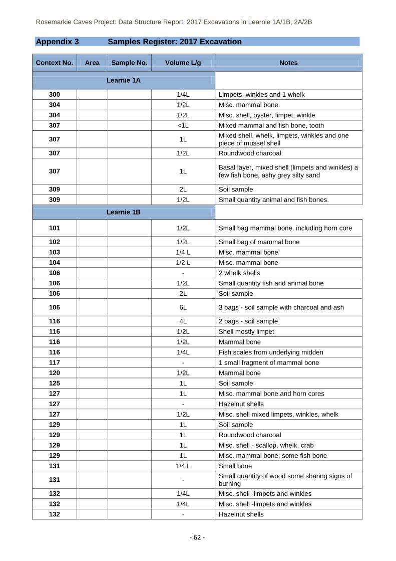
Rosemarkie Caves Project: Data Structure Report: 2017 Excavations in Learnie 1A/1B, 2A/2B
- 62 -
Appendix 3 Samples Register: 2017 Excavation
Context No. Area Sample No. Volume L/g Notes
Learnie 1A
300 1/4L Limpets, winkles and 1 whelk
304 1/2L Misc. mammal bone
304 1/2L Misc. shell, oyster, limpet, winkle
307 <1L Mixed mammal and fish bone, tooth
307 1L Mixed shell, whelk, limpets, winkles and one piece of mussel shell
307 1/2L Roundwood charcoal
307 1L Basal layer, mixed shell (limpets and winkles) a few fish bone, ashy grey silty sand
309 2L Soil sample
309 1/2L Small quantity animal and fish bones.
Learnie 1B
101 1/2L Small bag mammal bone, including horn core
102 1/2L Small bag of mammal bone
103 1/4 L Misc. mammal bone
104 1/2 L Misc. mammal bone
106 - 2 whelk shells
106 1/2L Small quantity fish and animal bone
106 2L Soil sample
106 6L 3 bags - soil sample with charcoal and ash
116 4L 2 bags - soil sample
116 1/2L Shell mostly limpet
116 1/2L Mammal bone
116 1/4L Fish scales from underlying midden
117 - 1 small fragment of mammal bone
120 1/2L Mammal bone
125 1L Soil sample
127 1L Misc. mammal bone and horn cores
127 - Hazelnut shells
127 1/2L Misc. shell mixed limpets, winkles, whelk
129 1L Soil sample
129 1L Roundwood charcoal
129 1L Misc. shell - scallop, whelk, crab
129 1L Misc. mammal bone, some fish bone
131 1/4 L Small bone
131 - Small quantity of wood some sharing signs of burning
132 1/4L Misc. shell -limpets and winkles
132 1/4L Misc. shell -limpets and winkles
132 - Hazelnut shells
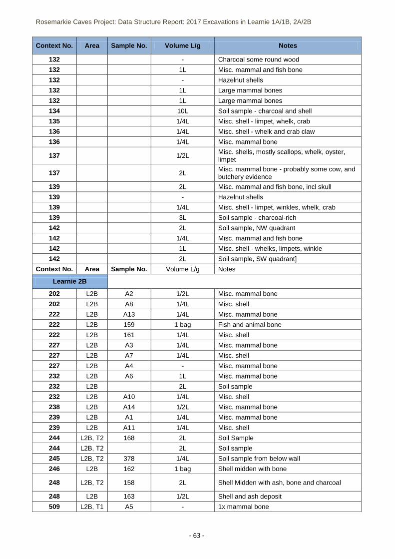
Rosemarkie Caves Project: Data Structure Report: 2017 Excavations in Learnie 1A/1B, 2A/2B
- 63 -
Context No. Area Sample No. Volume L/g Notes
132 - Charcoal some round wood
132 1L Misc. mammal and fish bone
132 - Hazelnut shells
132 1L Large mammal bones
132 1L Large mammal bones
134 10L Soil sample - charcoal and shell
135 1/4L Misc. shell - limpet, whelk, crab
136 1/4L Misc. shell - whelk and crab claw
136 1/4L Misc. mammal bone
137 1/2L Misc. shells, mostly scallops, whelk, oyster, limpet
137 2L Misc. mammal bone - probably some cow, and butchery evidence
139 2L Misc. mammal and fish bone, incl skull
139 - Hazelnut shells
139 1/4L Misc. shell - limpet, winkles, whelk, crab
139 3L Soil sample - charcoal-rich
142 2L Soil sample, NW quadrant
142 1/4L Misc. mammal and fish bone
142 1L Misc. shell - whelks, limpets, winkle
142 2L Soil sample, SW quadrant]
Context No. Area Sample No. Volume L/g Notes
Learnie 2B
202 L2B A2 1/2L Misc. mammal bone
202 L2B A8 1/4L Misc. shell
222 L2B A13 1/4L Misc. mammal bone
222 L2B 159 1 bag Fish and animal bone
222 L2B 161 1/4L Misc. shell
227 L2B A3 1/4L Misc. mammal bone
227 L2B A7 1/4L Misc. shell
227 L2B A4 - Misc. mammal bone
232 L2B A6 1L Misc. mammal bone
232 L2B 2L Soil sample
232 L2B A10 1/4L Misc. shell
238 L2B A14 1/2L Misc. mammal bone
239 L2B A1 1/4L Misc. mammal bone
239 L2B A11 1/4L Misc. shell
244 L2B, T2 168 2L Soil Sample
244 L2B, T2 2L Soil sample
245 L2B, T2 378 1/4L Soil sample from below wall
246 L2B 162 1 bag Shell midden with bone
248 L2B, T2 158 2L Shell Midden with ash, bone and charcoal
248 L2B 163 1/2L Shell and ash deposit
509 L2B, T1 A5 - 1x mammal bone
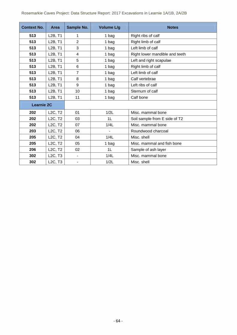
Rosemarkie Caves Project: Data Structure Report: 2017 Excavations in Learnie 1A/1B, 2A/2B
- 64 -
Context No. Area Sample No. Volume L/g Notes
513 L2B, T1 1 1 bag Right ribs of calf
513 L2B, T1 2 1 bag Right limb of calf
513 L2B, T1 3 1 bag Left limb of calf
513 L2B, T1 4 1 bag Right lower mandible and teeth
513 L2B, T1 5 1 bag Left and right scapulae
513 L2B, T1 6 1 bag Right limb of calf
513 L2B, T1 7 1 bag Left limb of calf
513 L2B, T1 8 1 bag Calf vertebrae
513 L2B, T1 9 1 bag Left ribs of calf
513 L2B, T1 10 1 bag Sternum of calf
513 L2B, T1 11 1 bag Calf bone
Learnie 2C
202 L2C, T2 01 1/2L Misc. mammal bone
202 L2C, T2 03 1L Soil sample from E side of T2
202 L2C, T2 07 1/4L Misc. mammal bone
203 L2C, T2 06 - Roundwood charcoal
205 L2C, T2 04 1/4L Misc. shell
205 L2C, T2 05 1 bag Misc. mammal and fish bone
206 L2C, T2 02 1L Sample of ash layer
302 L2C, T3 - 1/4L Misc. mammal bone
302 L2C, T3 - 1/2L Misc. shell
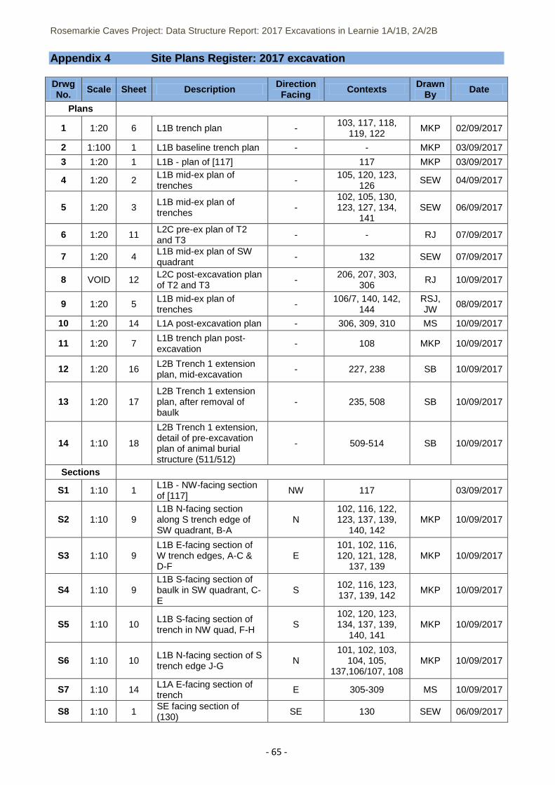
Rosemarkie Caves Project: Data Structure Report: 2017 Excavations in Learnie 1A/1B, 2A/2B
- 65 -
Appendix 4 Site Plans Register: 2017 excavation
Drwg No. Scale Sheet Description Direction
Facing Contexts Drawn By Date
Plans
1 1:20 6 L1B trench plan - 103, 117, 118,
119, 122 MKP 02/09/2017
2 1:100 1 L1B baseline trench plan - - MKP 03/09/2017
3 1:20 1 L1B - plan of [117] 117 MKP 03/09/2017
4 1:20 2 L1B mid-ex plan of trenches
- 105, 120, 123,
126 SEW 04/09/2017
5 1:20 3 L1B mid-ex plan of trenches
- 102, 105, 130, 123, 127, 134,
141 SEW 06/09/2017
6 1:20 11 L2C pre-ex plan of T2 and T3
- - RJ 07/09/2017
7 1:20 4 L1B mid-ex plan of SW quadrant
- 132 SEW 07/09/2017
8 VOID 12 L2C post-excavation plan of T2 and T3
- 206, 207, 303,
306 RJ 10/09/2017
9 1:20 5 L1B mid-ex plan of trenches
- 106/7, 140, 142,
144 RSJ, JW
08/09/2017
10 1:20 14 L1A post-excavation plan - 306, 309, 310 MS 10/09/2017
11 1:20 7 L1B trench plan post-excavation
- 108 MKP 10/09/2017
12 1:20 16 L2B Trench 1 extension plan, mid-excavation
- 227, 238 SB 10/09/2017
13 1:20 17 L2B Trench 1 extension plan, after removal of baulk
- 235, 508 SB 10/09/2017
14 1:10 18
L2B Trench 1 extension, detail of pre-excavation plan of animal burial structure (511/512)
- 509-514 SB 10/09/2017
Sections
S1 1:10 1 L1B - NW-facing section of [117]
NW 117 03/09/2017
S2 1:10 9 L1B N-facing section along S trench edge of SW quadrant, B-A
N 102, 116, 122, 123, 137, 139,
140, 142 MKP 10/09/2017
S3 1:10 9 L1B E-facing section of W trench edges, A-C & D-F
E 101, 102, 116, 120, 121, 128,
137, 139 MKP 10/09/2017
S4 1:10 9 L1B S-facing section of baulk in SW quadrant, C-E
S 102, 116, 123, 137, 139, 142
MKP 10/09/2017
S5 1:10 10 L1B S-facing section of trench in NW quad, F-H
S 102, 120, 123, 134, 137, 139,
140, 141 MKP 10/09/2017
S6 1:10 10 L1B N-facing section of S trench edge J-G
N 101, 102, 103,
104, 105, 137,106/107, 108
MKP 10/09/2017
S7 1:10 14 L1A E-facing section of trench
E 305-309 MS 10/09/2017
S8 1:10 1 SE facing section of (130)
SE 130 SEW 06/09/2017
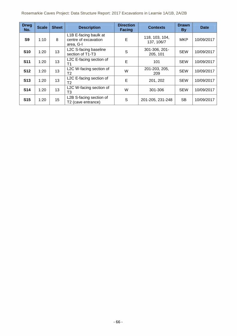
Rosemarkie Caves Project: Data Structure Report: 2017 Excavations in Learnie 1A/1B, 2A/2B
- 66 -
Drwg No. Scale Sheet Description Direction
Facing Contexts Drawn By Date
S9 1:10 8 L1B E-facing baulk at centre of excavation area, G-I
E 118, 103, 104,
137, 106/7 MKP 10/09/2017
S10 1:20 13 L2C S-facing baseline section of T1-T3
S 301-306, 201-
205, 101 SEW 10/09/2017
S11 1:20 13 L2C E-facing section of T1 E 101 SEW 10/09/2017
S12 1:20 13 L2C W-facing section of T2
W 201-203, 205,
209 SEW 10/09/2017
S13 1:20 13 L2C E-facing section of T2
E 201, 202 SEW 10/09/2017
S14 1:20 13 L2C W-facing section of T3
W 301-306 SEW 10/09/2017
S15 1:20 15 L2B S-facing section of T2 (cave entrance)
S 201-205, 231-248 SB 10/09/2017
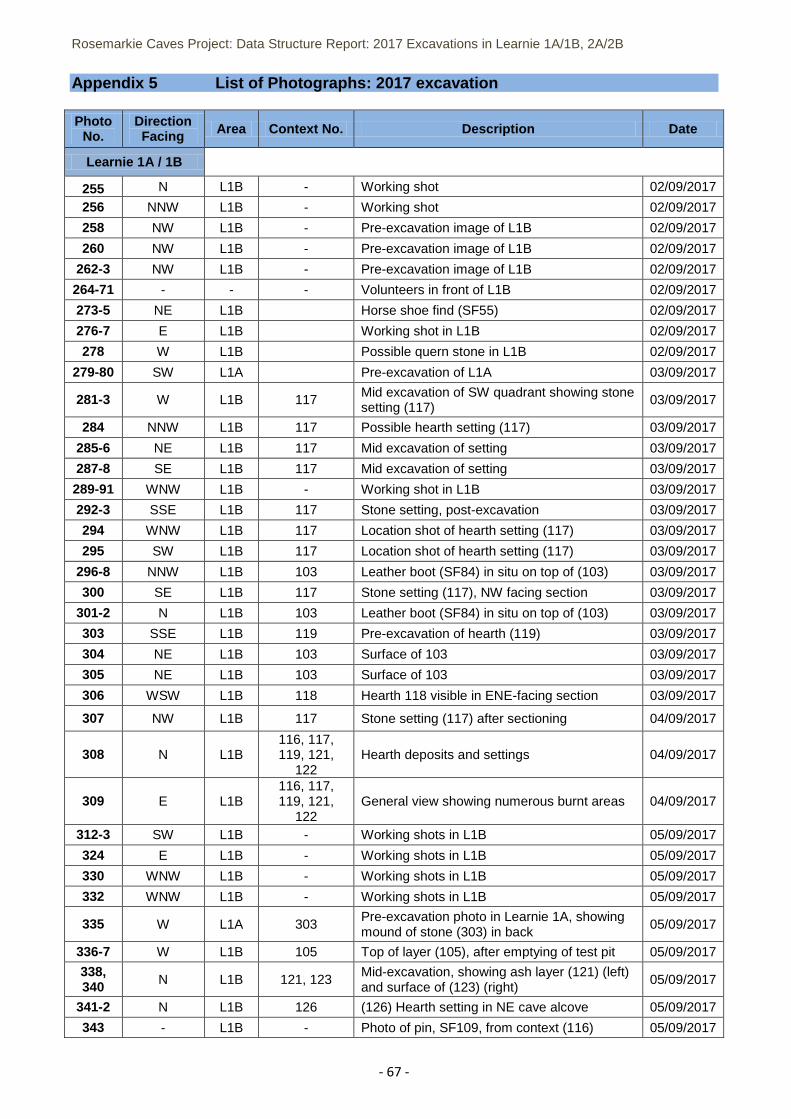
Rosemarkie Caves Project: Data Structure Report: 2017 Excavations in Learnie 1A/1B, 2A/2B
- 67 -
Appendix 5 List of Photographs: 2017 excavation
Photo No.
Direction Facing Area Context No. Description Date
Learnie 1A / 1B
255 N L1B - Working shot 02/09/2017
256 NNW L1B - Working shot 02/09/2017
258 NW L1B - Pre-excavation image of L1B 02/09/2017
260 NW L1B - Pre-excavation image of L1B 02/09/2017
262-3 NW L1B - Pre-excavation image of L1B 02/09/2017
264-71 - - - Volunteers in front of L1B 02/09/2017
273-5 NE L1B Horse shoe find (SF55) 02/09/2017
276-7 E L1B Working shot in L1B 02/09/2017
278 W L1B Possible quern stone in L1B 02/09/2017
279-80 SW L1A Pre-excavation of L1A 03/09/2017
281-3 W L1B 117 Mid excavation of SW quadrant showing stone setting (117)
03/09/2017
284 NNW L1B 117 Possible hearth setting (117) 03/09/2017
285-6 NE L1B 117 Mid excavation of setting 03/09/2017
287-8 SE L1B 117 Mid excavation of setting 03/09/2017
289-91 WNW L1B - Working shot in L1B 03/09/2017
292-3 SSE L1B 117 Stone setting, post-excavation 03/09/2017
294 WNW L1B 117 Location shot of hearth setting (117) 03/09/2017
295 SW L1B 117 Location shot of hearth setting (117) 03/09/2017
296-8 NNW L1B 103 Leather boot (SF84) in situ on top of (103) 03/09/2017
300 SE L1B 117 Stone setting (117), NW facing section 03/09/2017
301-2 N L1B 103 Leather boot (SF84) in situ on top of (103) 03/09/2017
303 SSE L1B 119 Pre-excavation of hearth (119) 03/09/2017
304 NE L1B 103 Surface of 103 03/09/2017
305 NE L1B 103 Surface of 103 03/09/2017
306 WSW L1B 118 Hearth 118 visible in ENE-facing section 03/09/2017
307 NW L1B 117 Stone setting (117) after sectioning 04/09/2017
308 N L1B 116, 117, 119, 121,
122 Hearth deposits and settings 04/09/2017
309 E L1B 116, 117, 119, 121,
122 General view showing numerous burnt areas 04/09/2017
312-3 SW L1B - Working shots in L1B 05/09/2017
324 E L1B - Working shots in L1B 05/09/2017
330 WNW L1B - Working shots in L1B 05/09/2017
332 WNW L1B - Working shots in L1B 05/09/2017
335 W L1A 303 Pre-excavation photo in Learnie 1A, showing mound of stone (303) in back
05/09/2017
336-7 W L1B 105 Top of layer (105), after emptying of test pit 05/09/2017
338, 340 N L1B 121, 123
Mid-excavation, showing ash layer (121) (left) and surface of (123) (right)
05/09/2017
341-2 N L1B 126 (126) Hearth setting in NE cave alcove 05/09/2017
343 - L1B - Photo of pin, SF109, from context (116) 05/09/2017
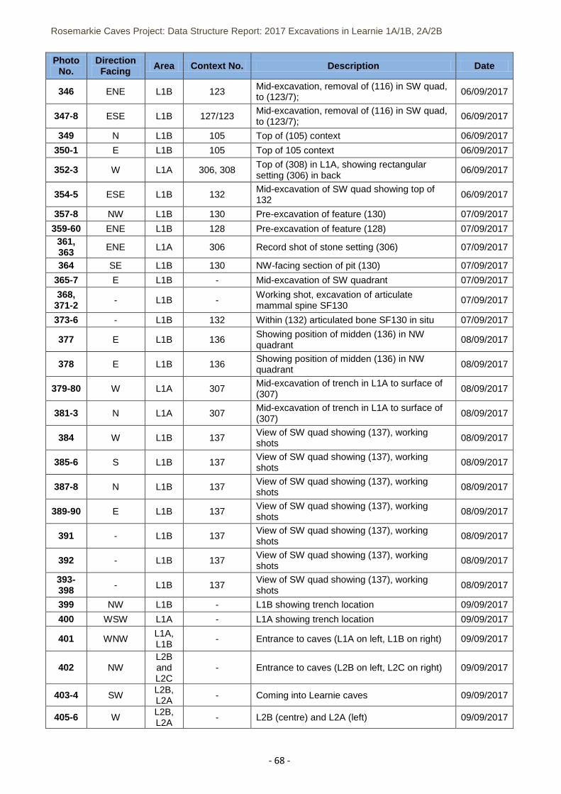
Rosemarkie Caves Project: Data Structure Report: 2017 Excavations in Learnie 1A/1B, 2A/2B
- 68 -
Photo No.
Direction Facing Area Context No. Description Date
346 ENE L1B 123 Mid-excavation, removal of (116) in SW quad, to (123/7);
06/09/2017
347-8 ESE L1B 127/123 Mid-excavation, removal of (116) in SW quad, to (123/7);
06/09/2017
349 N L1B 105 Top of (105) context 06/09/2017
350-1 E L1B 105 Top of 105 context 06/09/2017
352-3 W L1A 306, 308 Top of (308) in L1A, showing rectangular setting (306) in back
06/09/2017
354-5 ESE L1B 132 Mid-excavation of SW quad showing top of 132
06/09/2017
357-8 NW L1B 130 Pre-excavation of feature (130) 07/09/2017
359-60 ENE L1B 128 Pre-excavation of feature (128) 07/09/2017 361, 363 ENE L1A 306 Record shot of stone setting (306) 07/09/2017
364 SE L1B 130 NW-facing section of pit (130) 07/09/2017
365-7 E L1B - Mid-excavation of SW quadrant 07/09/2017
368, 371-2 - L1B -
Working shot, excavation of articulate mammal spine SF130
07/09/2017
373-6 - L1B 132 Within (132) articulated bone SF130 in situ 07/09/2017
377 E L1B 136 Showing position of midden (136) in NW quadrant
08/09/2017
378 E L1B 136 Showing position of midden (136) in NW quadrant
08/09/2017
379-80 W L1A 307 Mid-excavation of trench in L1A to surface of (307)
08/09/2017
381-3 N L1A 307 Mid-excavation of trench in L1A to surface of (307)
08/09/2017
384 W L1B 137 View of SW quad showing (137), working shots
08/09/2017
385-6 S L1B 137 View of SW quad showing (137), working shots
08/09/2017
387-8 N L1B 137 View of SW quad showing (137), working shots
08/09/2017
389-90 E L1B 137 View of SW quad showing (137), working shots
08/09/2017
391 - L1B 137 View of SW quad showing (137), working shots
08/09/2017
392 - L1B 137 View of SW quad showing (137), working shots
08/09/2017
393-398 - L1B 137
View of SW quad showing (137), working shots
08/09/2017
399 NW L1B - L1B showing trench location 09/09/2017
400 WSW L1A - L1A showing trench location 09/09/2017
401 WNW L1A, L1B
- Entrance to caves (L1A on left, L1B on right) 09/09/2017
402 NW L2B and L2C
- Entrance to caves (L2B on left, L2C on right) 09/09/2017
403-4 SW L2B, L2A - Coming into Learnie caves 09/09/2017
405-6 W L2B, L2A
- L2B (centre) and L2A (left) 09/09/2017
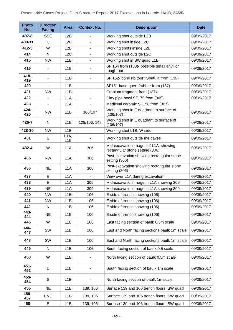
Rosemarkie Caves Project: Data Structure Report: 2017 Excavations in Learnie 1A/1B, 2A/2B
- 69 -
Photo No.
Direction Facing Area Context No. Description Date
407-8 SSE L2B - Working shot outside L2B 09/09/2017
409-11 E L2C - Working shot inside L2C 09/09/2017
412-3 W L2B - Working shots inside L2B 09/09/2017
414 N L2C - Working shot outside L2C 09/09/2017
415 NW L1B - Working shot in SW quad L1B 09/09/2017
416 - L1B - SF 164 from (138)- possible small anvil or rough-out
09/09/2017
418-419 - L1B - SF 152- bone rib tool? Spatula from (139) 09/09/2017
420 - L1B SF151 base quern/rubber from (137) 09/09/2017
421 NW L1B - Cranium fragment from (137) 09/09/2017
422 - L1A - Clay pipe bowl SF175 from (305) 09/09/2017
423 - L1A - Medieval ceramic SF158 from (307)
424-425 NW L1B 106/107
Working shot in E quadrant to surface of (106/107)
09/09/2017
426-7 N L1B 129/106, 143 Working shot in E quadrant to surface of (106/107)
09/09/2017
428-30 NW L1B - Working shot L1B, W side 09/09/2017
431 S L1A, L1B
- Working shot outside the caves 09/09/2017
432-4 W L1A 306 Mid-excavation images of L1A, showing rectangular stone setting (306)
09/09/2017
435 NW L1A 306 Post-excavation showing rectangular stone setting (306)
09/09/2017
436 NE L1A 306 Post-excavation showing rectangular stone setting (306)
09/09/2017
437 E L1A - View over L1A during excavation 09/09/2017
438 E L1A 309 Mid-excavation image in L1A showing 309 09/09/2017
439 NE L1A 309 Mid-excavation image in L1A showing 309 09/09/2017
440 NW L1B 106 E side of trench showing (106) 09/09/2017
441 NW L1B 106 E side of trench showing (106) 09/09/2017
442 N L1B 106 E side of trench showing (106) 09/09/2017 443-444 NE L1B 106 E side of trench showing (106) 09/09/2017
445 W L1B 106 East facing section of baulk 0.5m scale 09/09/2017
446-447 SW L1B 106 East and North facing sections baulk 1m scale 09/09/2017
448 SW L1B 106 East and North facing sections baulk 1m scale 09/09/2017
449 N L1B 106 South facing section of baulk 0.5 scale 09/09/2017
450 W L1B - North facing section of baulk 0.5m scale 09/09/2017
451-452 E L1B - South facing section of baulk 1m scale 09/09/2017
453-454 S L1B - North facing section of baulk 1m scale 09/09/2017
455 NE L1B 139, 106 Surface 139 and 106 trench floors, SW quad 09/09/2017 456-457 ENE L1B 139, 106 Surface 139 and 106 trench floors, SW quad 09/09/2017
458- E L1B 139, 106 Surface 139 and 106 trench floors, SW quad 09/09/2017
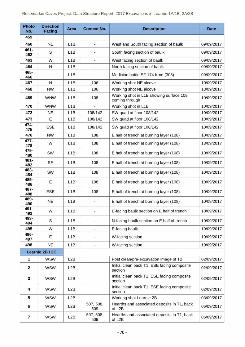
Rosemarkie Caves Project: Data Structure Report: 2017 Excavations in Learnie 1A/1B, 2A/2B
- 70 -
Photo No.
Direction Facing Area Context No. Description Date
459
460 NE L1B - West and South facing section of baulk 09/09/2017 461-462 S L1B - South facing section of baulk 09/09/2017
463 W L1B - West facing section of baulk 09/09/2017
464 N L1B - North facing section of baulk 09/09/2017 465-466 - L1B - Medicine bottle SF 174 from (305) 09/09/2017
467 N L1B 106 Working shot NE alcove 10/09/2017
468 NW L1B 106 Working shot NE alcove 13/09/2017
469 WNW L1B 108 Working shot in L1B showing surface 108 coming through
10/09/2017
470 WNW L1B - Working shot in L1B 10/09/2017
472 NE L1B 108/142 SW quad at floor 108/142 10/09/2017
473 E L1B 108/142 SW quad at floor 108/142 10/09/2017 474-475 ESE L1B 108/142 SW quad at floor 108/142 10/09/2017
476 NW L1B 108 E half of trench at burning layer (108) 10/09/2017 477-478 W L1B 108 E half of trench at burning layer (108) 13/09/2017
479-480 SW L1B 108 E half of trench at burning layer (108) 10/09/2017
481-482 SE L1B 108 E half of trench at burning layer (108) 10/09/2017
483-484 SW L1B 108 E half of trench at burning layer (108) 10/09/2017
485-486 E L1B 108 E half of trench at burning layer (108) 10/09/2017
487-488 ESE L1B 108 E half of trench at burning layer (108) 10/09/2017
489-490 NE L1B - E half of trench at burning layer (108) 10/09/2017
491-492 W L1B - E-facing baulk section on E half of trench 10/09/2017
493-494 S L1B - N-facing baulk section on E half of trench 10/09/2017
495 W L1B - E-facing baulk 10/09/2017 496-497 E L1B - W-facing section 10/09/2017
498 NE L1B - W-facing section 10/09/2017
Learnie 2B / 2C
1 WSW L2B Post clean/pre-excavation image of T2 02/09/2017
2 WSW L2B Initial clean back T1, ESE facing composite section
02/09/2017
3 WSW L2B Initial clean back T1, ESE facing composite section
02/09/2017
4 WSW L2B Initial clean back T1, ESE facing composite section
02/09/2017
5 WSW L2B Working shot Learnie 2B 03/09/2017
6 WSW L2B 507, 508, 509
Hearths and associated deposits in T1, back of L2B
06/09/2017
7 WSW L2B 507, 508,
509 Hearths and associated deposits in T1, back of L2B
06/09/2017
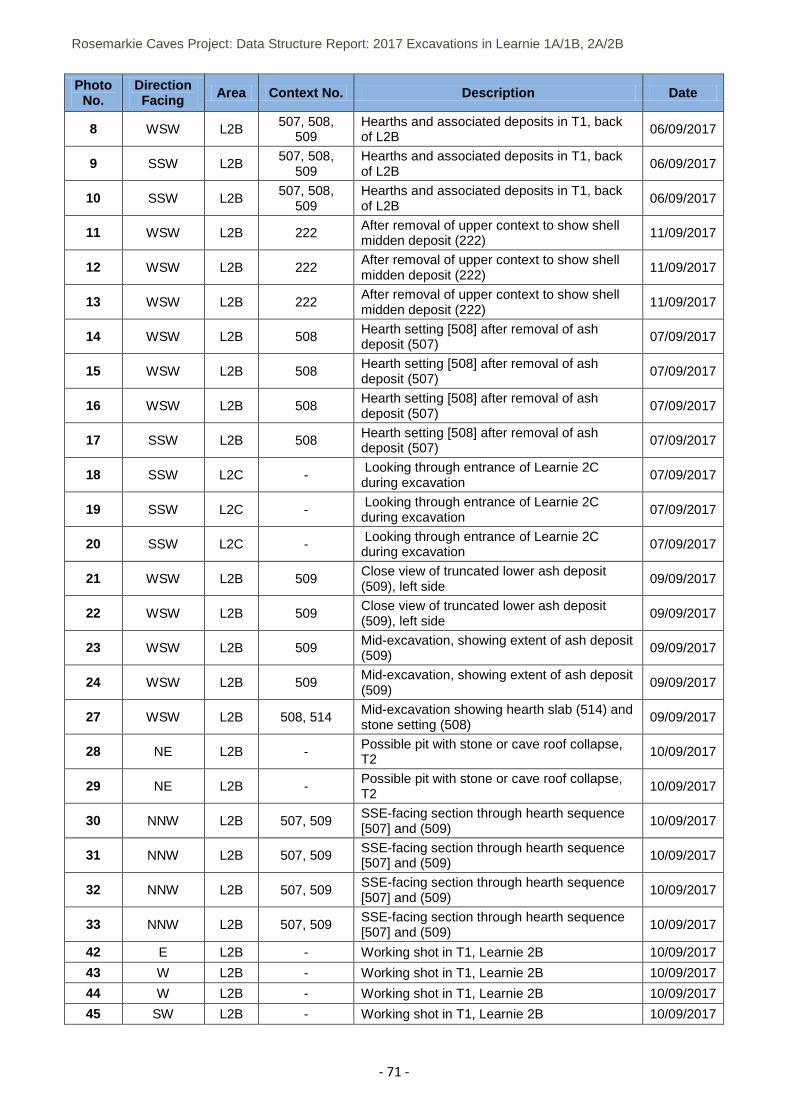
Rosemarkie Caves Project: Data Structure Report: 2017 Excavations in Learnie 1A/1B, 2A/2B
- 71 -
Photo No.
Direction Facing Area Context No. Description Date
8 WSW L2B 507, 508, 509
Hearths and associated deposits in T1, back of L2B
06/09/2017
9 SSW L2B 507, 508,
509 Hearths and associated deposits in T1, back of L2B
06/09/2017
10 SSW L2B 507, 508,
509 Hearths and associated deposits in T1, back of L2B
06/09/2017
11 WSW L2B 222 After removal of upper context to show shell midden deposit (222)
11/09/2017
12 WSW L2B 222 After removal of upper context to show shell midden deposit (222)
11/09/2017
13 WSW L2B 222 After removal of upper context to show shell midden deposit (222)
11/09/2017
14 WSW L2B 508 Hearth setting [508] after removal of ash deposit (507)
07/09/2017
15 WSW L2B 508 Hearth setting [508] after removal of ash deposit (507)
07/09/2017
16 WSW L2B 508 Hearth setting [508] after removal of ash deposit (507)
07/09/2017
17 SSW L2B 508 Hearth setting [508] after removal of ash deposit (507)
07/09/2017
18 SSW L2C - Looking through entrance of Learnie 2C during excavation
07/09/2017
19 SSW L2C - Looking through entrance of Learnie 2C during excavation
07/09/2017
20 SSW L2C - Looking through entrance of Learnie 2C during excavation
07/09/2017
21 WSW L2B 509 Close view of truncated lower ash deposit (509), left side
09/09/2017
22 WSW L2B 509 Close view of truncated lower ash deposit (509), left side
09/09/2017
23 WSW L2B 509 Mid-excavation, showing extent of ash deposit (509)
09/09/2017
24 WSW L2B 509 Mid-excavation, showing extent of ash deposit (509)
09/09/2017
27 WSW L2B 508, 514 Mid-excavation showing hearth slab (514) and stone setting (508)
09/09/2017
28 NE L2B - Possible pit with stone or cave roof collapse, T2
10/09/2017
29 NE L2B - Possible pit with stone or cave roof collapse, T2
10/09/2017
30 NNW L2B 507, 509 SSE-facing section through hearth sequence [507] and (509)
10/09/2017
31 NNW L2B 507, 509 SSE-facing section through hearth sequence [507] and (509)
10/09/2017
32 NNW L2B 507, 509 SSE-facing section through hearth sequence [507] and (509)
10/09/2017
33 NNW L2B 507, 509 SSE-facing section through hearth sequence [507] and (509)
10/09/2017
42 E L2B - Working shot in T1, Learnie 2B 10/09/2017
43 W L2B - Working shot in T1, Learnie 2B 10/09/2017
44 W L2B - Working shot in T1, Learnie 2B 10/09/2017
45 SW L2B - Working shot in T1, Learnie 2B 10/09/2017
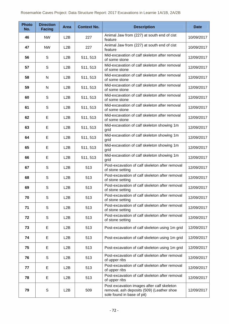
Rosemarkie Caves Project: Data Structure Report: 2017 Excavations in Learnie 1A/1B, 2A/2B
- 72 -
Photo No.
Direction Facing Area Context No. Description Date
46 NW L2B 227 Animal Jaw from (227) at south end of cist feature
10/09/2017
47 NW L2B 227 Animal Jaw from (227) at south end of cist feature
10/09/2017
56 S L2B 511, 513 Mid-excavation of calf skeleton after removal of some stone
12/09/2017
57 S L2B 511, 513 Mid-excavation of calf skeleton after removal of some stone
12/09/2017
58 N L2B 511, 513 Mid-excavation of calf skeleton after removal of some stone
12/09/2017
59 N L2B 511, 513 Mid-excavation of calf skeleton after removal of some stone
12/09/2017
60 S L2B 511, 513 Mid-excavation of calf skeleton after removal of some stone
12/09/2017
61 S L2B 511, 513 Mid-excavation of calf skeleton after removal of some stone
12/09/2017
62 E L2B 511, 513 Mid-excavation of calf skeleton after removal of some stone
12/09/2017
63 E L2B 511, 513 Mid-excavation of calf skeleton showing 1m grid
12/09/2017
64 E L2B 511, 513 Mid-excavation of calf skeleton showing 1m grid
12/09/2017
65 E L2B 511, 513 Mid-excavation of calf skeleton showing 1m grid
12/09/2017
66 E L2B 511, 513 Mid-excavation of calf skeleton showing 1m grid
12/09/2017
67 S L2B 513 Post-excavation of calf skeleton after removal of stone setting
12/09/2017
68 S L2B 513 Post-excavation of calf skeleton after removal of stone setting
12/09/2017
69 S L2B 513 Post-excavation of calf skeleton after removal of stone setting
12/09/2017
70 S L2B 513 Post-excavation of calf skeleton after removal of stone setting
12/09/2017
71 S L2B 513 Post-excavation of calf skeleton after removal of stone setting
12/09/2017
72 S L2B 513 Post-excavation of calf skeleton after removal of stone setting
12/09/2017
73 E L2B 513 Post-excavation of calf skeleton using 1m grid 12/09/2017
74 E L2B 513 Post-excavation of calf skeleton using 1m grid 12/09/2017
75 E L2B 513 Post-excavation of calf skeleton using 1m grid 12/09/2017
76 S L2B 513 Post-excavation of calf skeleton after removal of upper ribs
12/09/2017
77 E L2B 513 Post-excavation of calf skeleton after removal of upper ribs
12/09/2017
78 E L2B 513 Post-excavation of calf skeleton after removal of upper ribs
12/09/2017
79 S L2B 509 Post excavation images after calf skeleton removal, ash deposits (509) (Leather shoe sole found in base of pit)
12/09/2017
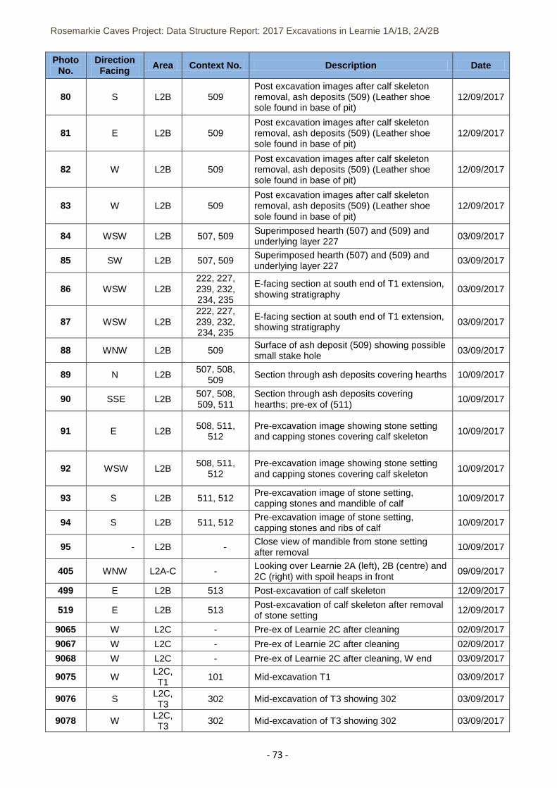
Rosemarkie Caves Project: Data Structure Report: 2017 Excavations in Learnie 1A/1B, 2A/2B
- 73 -
Photo No.
Direction Facing Area Context No. Description Date
80 S L2B 509 Post excavation images after calf skeleton removal, ash deposits (509) (Leather shoe sole found in base of pit)
12/09/2017
81 E L2B 509 Post excavation images after calf skeleton removal, ash deposits (509) (Leather shoe sole found in base of pit)
12/09/2017
82 W L2B 509 Post excavation images after calf skeleton removal, ash deposits (509) (Leather shoe sole found in base of pit)
12/09/2017
83 W L2B 509 Post excavation images after calf skeleton removal, ash deposits (509) (Leather shoe sole found in base of pit)
12/09/2017
84 WSW L2B 507, 509 Superimposed hearth (507) and (509) and underlying layer 227
03/09/2017
85 SW L2B 507, 509 Superimposed hearth (507) and (509) and underlying layer 227
03/09/2017
86 WSW L2B 222, 227, 239, 232, 234, 235
E-facing section at south end of T1 extension, showing stratigraphy
03/09/2017
87 WSW L2B 222, 227, 239, 232, 234, 235
E-facing section at south end of T1 extension, showing stratigraphy 03/09/2017
88 WNW L2B 509 Surface of ash deposit (509) showing possible small stake hole
03/09/2017
89 N L2B 507, 508,
509 Section through ash deposits covering hearths 10/09/2017
90 SSE L2B 507, 508, 509, 511
Section through ash deposits covering hearths; pre-ex of (511)
10/09/2017
91 E L2B 508, 511, 512
Pre-excavation image showing stone setting and capping stones covering calf skeleton
10/09/2017
92 WSW L2B 508, 511,
512 Pre-excavation image showing stone setting and capping stones covering calf skeleton
10/09/2017
93 S L2B 511, 512 Pre-excavation image of stone setting, capping stones and mandible of calf
10/09/2017
94 S L2B 511, 512 Pre-excavation image of stone setting, capping stones and ribs of calf
10/09/2017
95 - L2B - Close view of mandible from stone setting after removal
10/09/2017
405 WNW L2A-C - Looking over Learnie 2A (left), 2B (centre) and 2C (right) with spoil heaps in front
09/09/2017
499 E L2B 513 Post-excavation of calf skeleton 12/09/2017
519 E L2B 513 Post-excavation of calf skeleton after removal of stone setting
12/09/2017
9065 W L2C - Pre-ex of Learnie 2C after cleaning 02/09/2017
9067 W L2C - Pre-ex of Learnie 2C after cleaning 02/09/2017
9068 W L2C - Pre-ex of Learnie 2C after cleaning, W end 03/09/2017
9075 W L2C, T1
101 Mid-excavation T1 03/09/2017
9076 S L2C, T3
302 Mid-excavation of T3 showing 302 03/09/2017
9078 W L2C, T3
302 Mid-excavation of T3 showing 302 03/09/2017
Rosemarkie Caves Project: Data Structure Report: 2017 Excavations in Learnie 1A/1B, 2A/2B
- 74 -
Photo No.
Direction Facing Area Context No. Description Date
9084 W L2C, T3
303 Mid-excavation of T3 showing 303 05/09/2017
9085-6 S L2C, T3
303 Mid-excavation of T3 showing 303 05/09/2017
9088 W L2C, T2
202-4 Mid-excavation of T2 showing 202,203 (ash),204 (cobbles)
07/09/2017
9089 W L2C, T3
303 Mid-excavation T3 showing 303 07/09/2017
9090 S L2C, T3
303 Mid-excavation T3 showing 303 07/09/2017
9104 W L2C, T3
306 Sondage in NW of T3 showing bedrock 08/09/2017
9105 N L2C, T3
306 Section of sondage in T3 08/09/2017
9106 S L2C, T3 306 E part of T3 following removal 305 08/09/2017
9107 W L2C, T3
306 Overall view of T3 at limit of excavation 08/09/2017
9108 W L2C, T2
207 Mid-excavation, T2 09/09/2017
9109 E L2C, T2
207 Mid-excavation, T2 09/09/2017
9110 N L2C, T2
206 Post-excavation of T2, showing ash layer 206 09/09/2017
9111 N L2C, T2
206 Post-excavation of T2, showing ash layer 206 09/09/2017
9112 N L2C, T2
203, 204 Ash layer 203 and stone alignment 204 in T2 09/09/2017
9113 N L2C, T2
203, 204 Ash layer 203 overlying 204 09/09/2017
9114 S L2C, T2
203 Rock under 203 showing setting on bedrock in T2
09/09/2017
9115 E L2C, T2
203 Rock under 203 showing setting on bedrock in T2
09/09/2017
9116 W L2C, T2
203 Rock under 203 showing setting on bedrock in T2
09/09/2017
9117 - L2C, T2 203
Rock under 203 showing setting on bedrock from above S at top of frame 09/09/2017
9118 - L2C, T2
203 Rock under 203 showing setting on bedrock from above S at top of frame
09/09/2017
9119 W L2C, T2
207 Cobbled surface 207 section of ash 206 09/09/2017
9120 - L2C, T2
207 Overhead view of cobbled surface 207 section of ash 206
09/09/2017
9121 W L2C, T2
206 Section through ash 206 prior to sampling 09/09/2017
9122 - L2C, T2
206 Section through ash 206 prior after sampling 09/09/2017
9123 L2C, T2
206 Looking over ash layer 206 09/09/2017


