12
BIM for Surveyors Workshop BIM for Surveyors Workshop

BIM for Surveyors Workshop BIM for Surveyors Workshop

BIM for Surveyors Workshop BIM for Surveyors Workshop
Round Table: How to exchange Surveying Data with IFC?Chair: Christian Clemen

BIM for Surveyors Workshop BIM for Surveyors Workshop
Questions:
1. For which purpose do you use IFC? - stake out- large scale facility management / maintaining (roads, airports,..)- 3D cadastre / property /boundaries /- geographical context for design (deliver ifc to planers)- delivers as-built models as IFC + quality check

BIM for Surveyors Workshop BIM for Surveyors Workshop
Questions:
2. Which BIM Software are you working with- Revit (design Company)- Structural Software (Tekla)- Infraworks/Navisworks- Agisoft for data capture- ArchiCAD (good IFC export), Allplan, Sketchup- BIMServer.org ifc-database / EDM Jotne- FME / Dynamo

BIM for Surveyors Workshop BIM for Surveyors Workshop
Questions:
3. What should be improved?- Main problem: more simplicity would be good- Georeferencing for planning (link IFC directly)

BIM for Surveyors Workshop
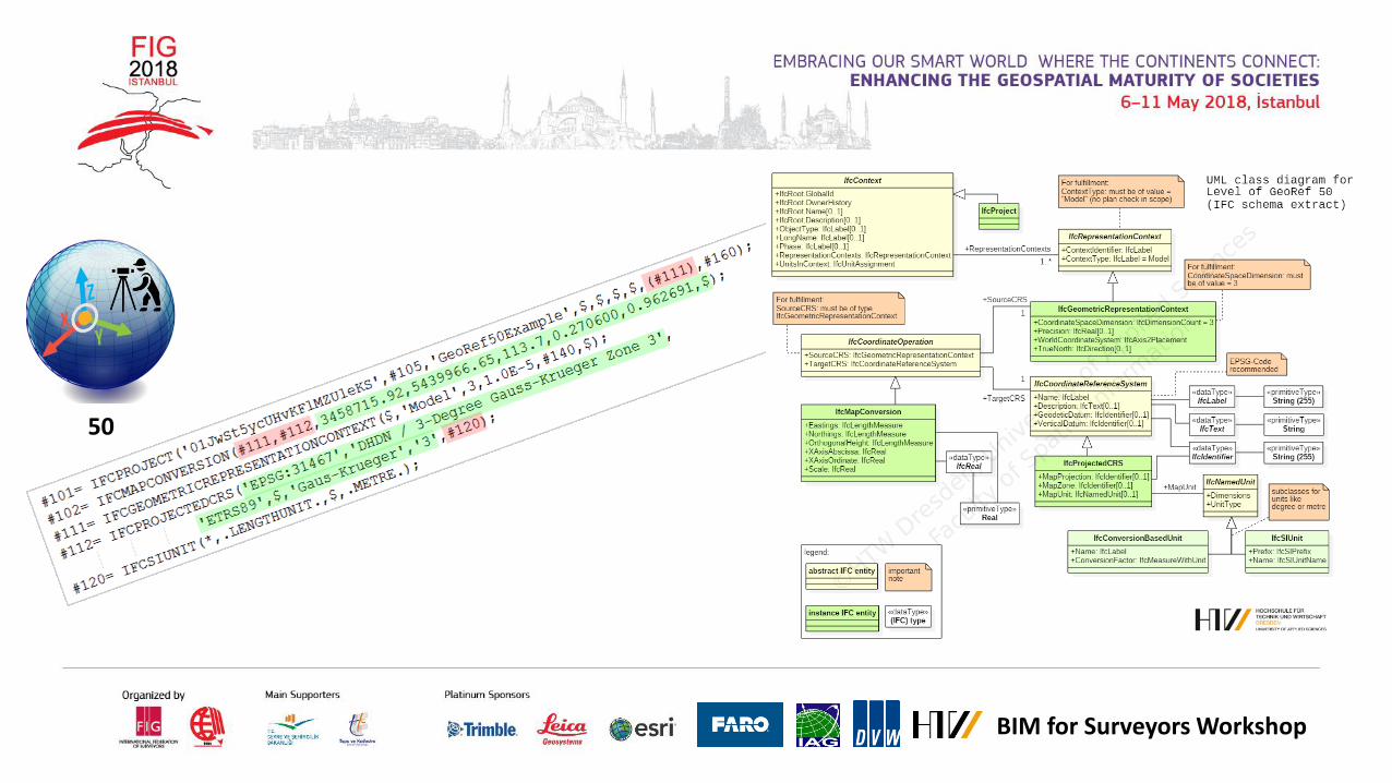
Level of Georeferencing (LoGeoRef) for BIM data drops
10 20 30 40 50
Using IFC (only) to georeference building models Pessimistic assumption: Building Models in IFC are not perfectly referenced in
practice. The higher the LoGeoRef is the more quality of georeferencing higher levels do not automatically include information out of lower levels. Each level
comprises their own IFC-schema attributes and is standing on its own. Decimal steps / intermediate steps possible e.g. for elevation, quality of attribute
values, project-specific extentions…

BIM for Surveyors Workshop
Level of Georeferencing (LoGeoRef) for BIM data drops
Simple Result: Logfile
Easy to use Checker

BIM for Surveyors Workshop
Level of Georeferencing (LoGeoRef) for BIM data drops
10

BIM for Surveyors Workshop
20
Level of Georeferencing (LoGeoRef) for BIM data drops

BIM for Surveyors Workshop
30
Level of Georeferencing (LoGeoRef) for BIM data drops

BIM for Surveyors Workshop
40
BIM for Surveyors Workshop
50


