52002NW2005 2.20787 DUFFELL LAKE 010 REPORT ON GEOPHYSICAL SURVEYS ON PROPERTY IN DUFFELL LAKE AREA SIOUX LOOKOUT MINING DIVISION ONTARIO RECEIVED DEC 1 3 2000 GEOSCIENCE ASSESSMENT _____OFFICE_____ E.W. BAZINET, P. Eng. 2 .2078? DATED AT SAN CARLOS, NUEVO GUAYMAS, SONORA, MEXICO NOVEMBER 30, 2000
Transcript
52002NW2005 2.20787DUFFELL LAKE
010
REPORT
ON
GEOPHYSICAL SURVEYS
ON PROPERTY
IN
DUFFELL LAKE AREA
SIOUX LOOKOUT MINING DIVISION
ONTARIO
RECEIVEDDEC 1 3 2000
GEOSCIENCE ASSESSMENT _____OFFICE_____
E.W. BAZINET, P. Eng.
2 .2078?
DATED AT SAN CARLOS, NUEVO GUAYMAS, SONORA, MEXICO
NOVEMBER 30, 2000
TABLE OF CONTENTS52002NW2005 2. 20787
Introduction
Property, Location and Access
Survey Method and Presentation of Results V.L.F. Electromagnetic Survey Horizontal Loop Electromagnetic Surveys Magnetometer Survey
Grid Lines
Interpretation of Results of the Geophysical Surveys
Conclusions and Recommendations
List of Illustrations
Name, Address and Qualifications of Person Who Supervised Surveys
Name and Address of Holder of the Mining Claims
List of References
REPORT
ON
GEOPHYSICAL SURVEYS
ON PROPERTY
IN
DUFFELL LAKE AREA
SIOUX LOOKOUT MINING DIVISION
ONTARIO
INTRODUCTION
A program of line cutting and ground geophysical work consisting of a V.L.F. electromagnetic survey, horizontal loop electromagnetic surveys at frequencies of 3555 Hz and 1777 Hz and a magnetometer survey was carried out on mining lands held by Iron Lake Minerals Inc. Claims covered by the program include 1092111,1092110,1092107, 1150425, 1150422, 1092103 and 1150754. The work was carried out between August 14, 2000 and November 30, 2000.
The object of the work was to more precisely define Anomaly "A", which had been defined by old surveys carried out over a set of north-south grid lines.
The old north-south grid lines do not traverse the anomaly normal to the strike, thereby poorly defining this feature. Consulting Engineer, M.W. Rennick, in his report dated May 3, 1999 recommended that new geophysical surveys, normal to the strike of the anomaly, be carried out to more precisely define Anomaly "A" and to provide accurate grid line control for a recommended diamond drilling program to explore the anomaly.
Anomaly "A" is only accessible by foot from either DufFell Lake or the Kawinogans River and requires several hours of strenuous walking to access the anomaly. Because of the long walk, the unit cost of carrying out the relatively small program was inordinately high. The area was accessed daily, on foot, from the Kawinogans River through a circuitous route around swamps and through extremely bad bush characterized by a great deal of windfall timber. Daily walking time to and from the job area approximated 5 hours leaving only limited time for actual line cutting and survey work. Charter helicopter service was not available in the area at the time the work was carried out.
In his report, Rennick recommended that as an initial program, 8 diamond drill holes, spaced at approximately 100-metre spacings, be drilled to explore Anomaly "A" along strike at a shallow depth.
The surveys successfully defined Anomaly "A" with grid lines traversing the strike of the anomaly in the optimum direction. The new grid system serves as a base for accurate positioning of drill holes along Anomaly "A".
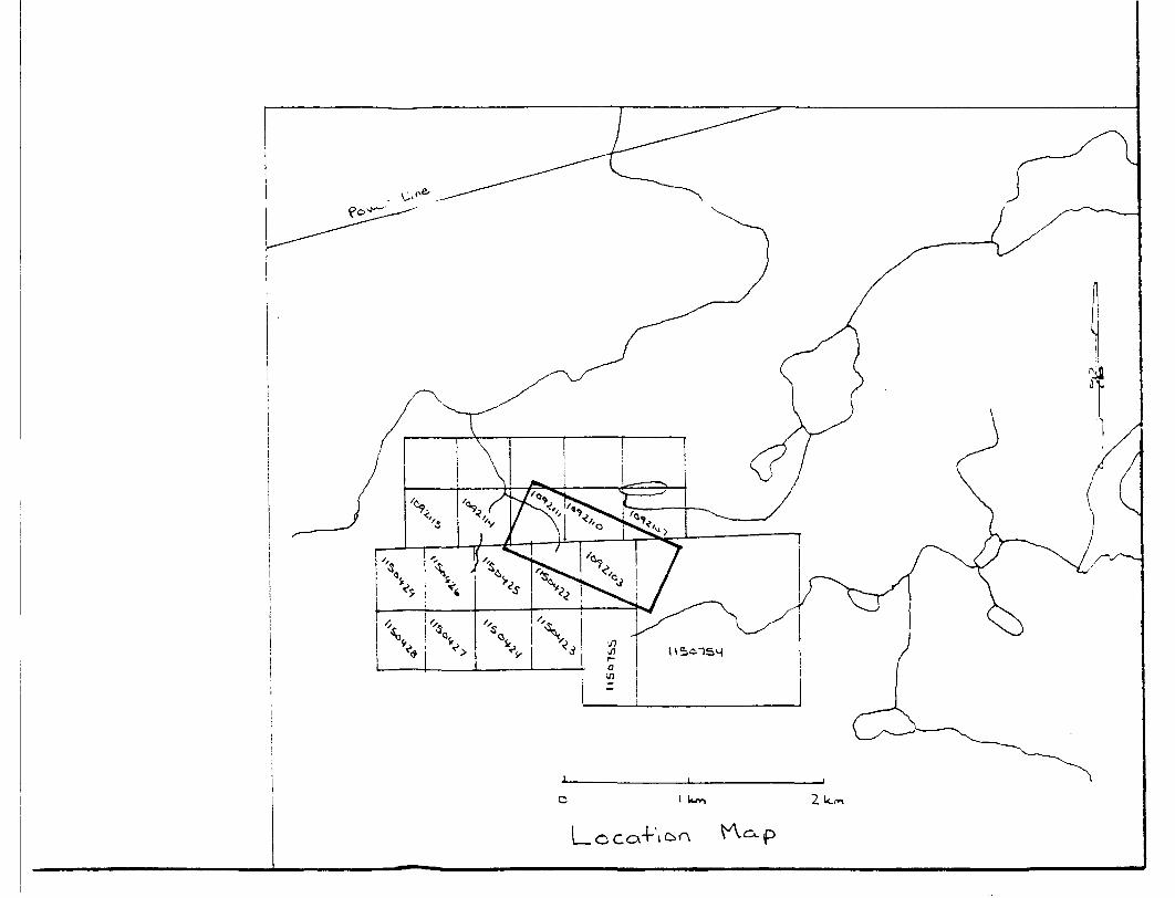
PROPERTY. LOCATION AND ACCESS
The survey covers parts of 1092111, 1092110, 1092107, 1150425, 1150422,1092103 and 1150754. They are located in the Duffell Lake Area of the Sioux Lookout Mining Division (Patricia Portion), District of Kenora, Ontario. The claims are accessed by footpath from Duffell Lake, a distance of from 2 to 3 miles or from the Kawinogans River, which is also at a distance of from 2 to 3 miles.
The property lies 35 miles southwest of the community of Pickle Lake.
Access to Duffell Lake is by charter bush aircraft operated out of Pickle Lake. Access is also possible by canoe route along the Kawinogans River system or by A.T.V. in summer via the winter road right of way to the Cat Lake Indian Reservation or in the winter via the latter road by truck.
SURVEY METHOD AND PRESENTATION OF RESULTS
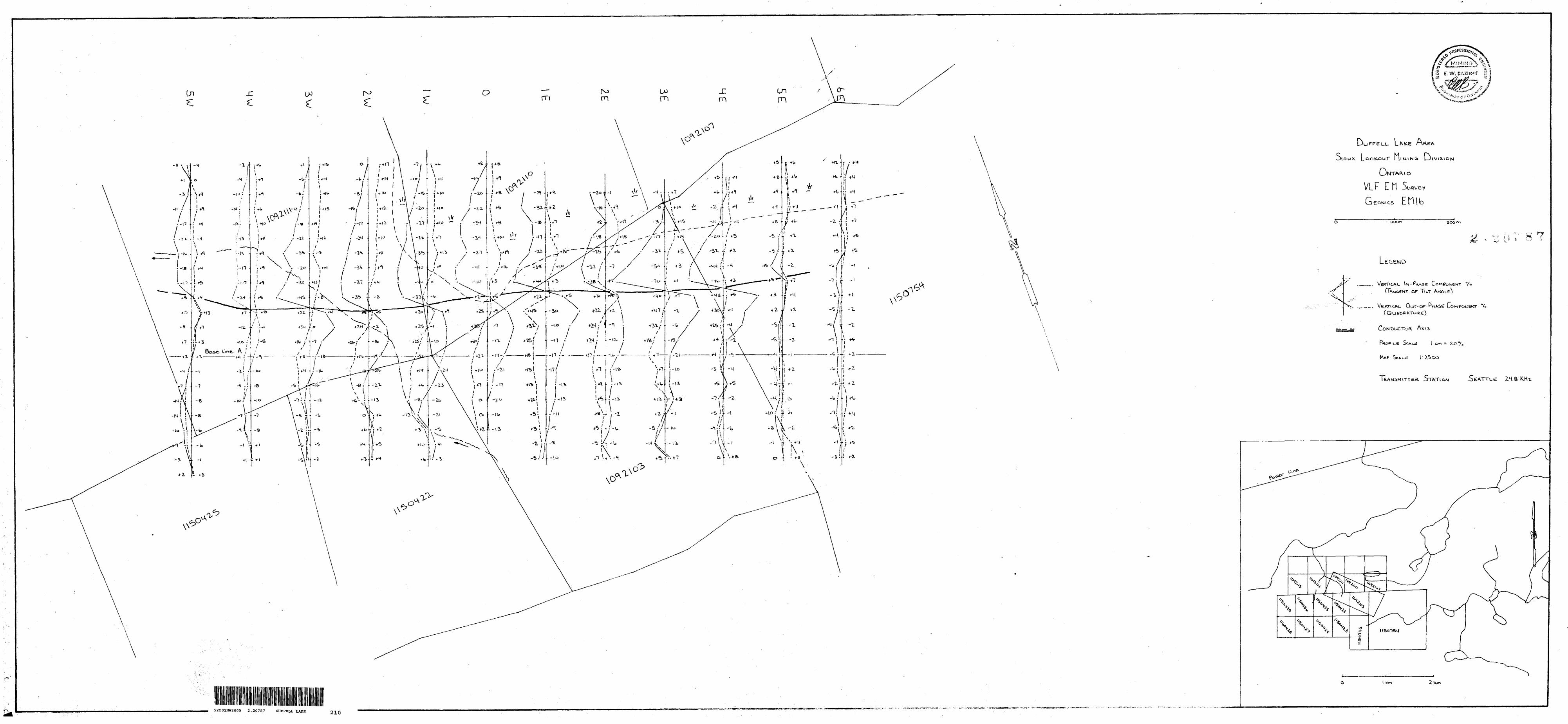
V.L.F. Electromagnetic Survey
The Geonics E.M 16 electromagnetic unit was employed to conduct the survey on the property. This instrument monitors the signal transmitted from very low frequency stations operating at various locations throughout the world for communications with military submarines. These V.L.F. radio stations have a vertical antenna. The antenna current is thus vertical, creating a concentric horizontal magnetic field, which is transmitted through the ground. When these magnetic fields encounter conductive geological bodies in the ground, secondary fields radiate from the bodies.
The E.M. 16 measures the vertical in-phase component (Tangent of the Tilt Angle) in percent and the vertical out-of-phase component (Quadrature) in percent, of the secondary field.
Transmitter stations are selected to result in a field approximately at right angles to the main strike of the conductive bodies or geological features being investigated, but a field of up to 450 to the main strike will yield acceptable results. The transmitter station at Seattle, Washington (24.8 Hz) was used to perform the survey on the property. Readings were recorded along grid lines at 25- metre intervals. The grid lines were spaced 100 metres apart.
The V.L.F. responses are plotted on the accompanying map at a scale of 1:2500.
Horizontal Loop Electromagnetic Surveys
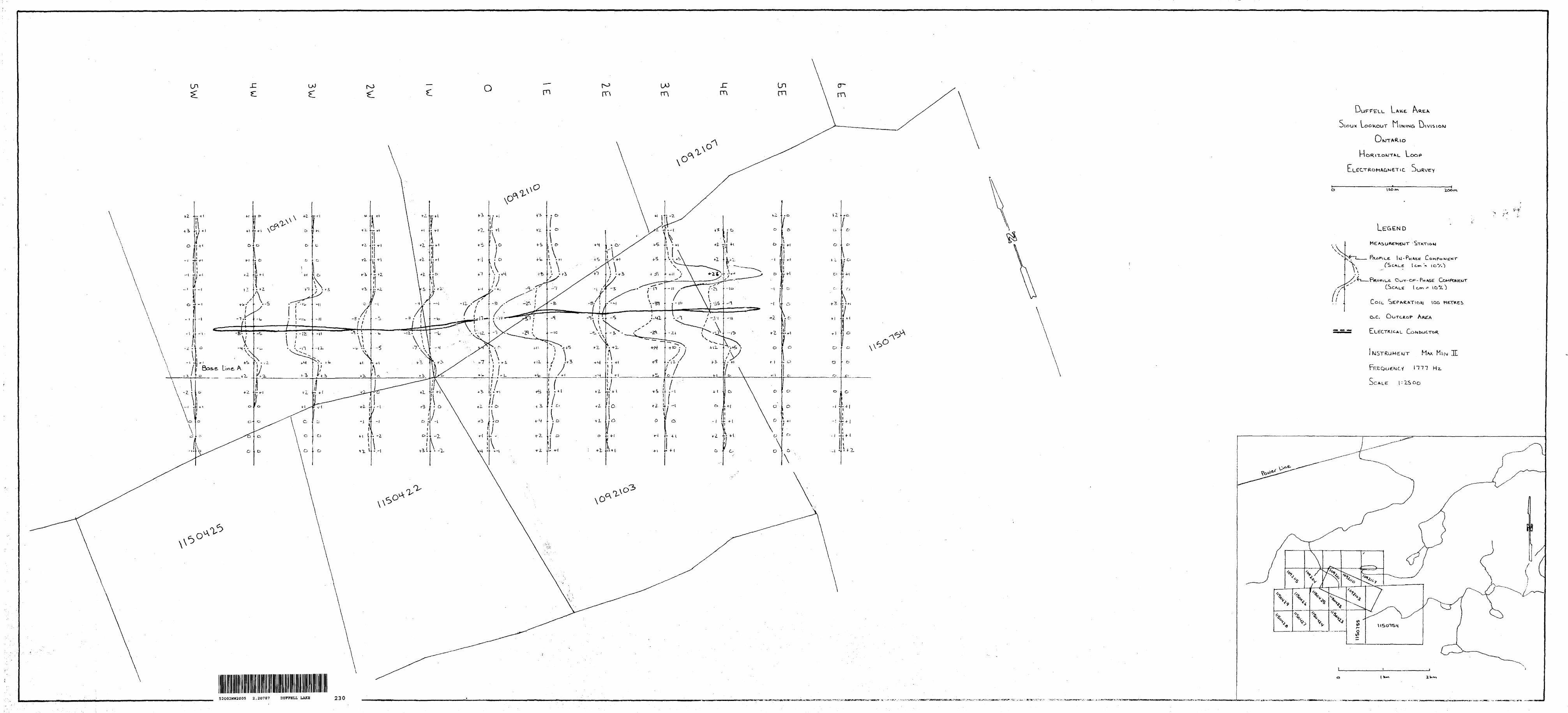
The horizontal loop electromagnetic surveys employed the Apex Parametrics Maxmin II electromagnetic instrument operated in the horizontal coil configuration with a transmitter-receiver separation of 100 metres. Readings of the in-phase and out-of-phase components of the resultant field at 3555 Hz and 1777 Hz were recorded at station intervals of 25 metres. Grid lines were established at 100-metre spacings. The ideal profile of the electromagnetic readings over the conductive body forms a curve with positive shoulders as the conductor is approached and a negative trough over the conductor. Both the in-phase and out-of-phase response show the same general curve over a conductor. The ratio between the in-phase and out-of-phase responses over a conductor provides a qualitative indication of the degree of conductivity as does the response at different transmitted frequencies. Conductivity thickness determinations (mhos) provide a quantitative method for comparing the degree of conductivity. In general, the ratio of the in-phase to out-of-phase response increases as the conductivity of the underlying body increases and a ratio of l .0 or greater is considered to be typical of a response generated by a massive sulfide body.
The electromagnetic responses as plotted on the accompanying map at a scale of 1:2500, are not corrected for topographic variations.
The surveys were conducted at frequencies of 3555 Hz and 1777 Hz to maximize the response from weakly mineralized zones and as an aid to differentiating between those V.L.F. conductors, which are caused by sulfides, and those, which are caused by conductive overburden or shear zones in bedrock.
Magnetometer Survey
The magnetometer survey employed the Geometrics Model G. 816 portable magnetometer, measuring the total intensity of the earth's magnetic field within an accuracy of plus or minus one gamma. The magnetic responses as plotted on the accompanying maps, are corrected for diurnal variation and instrument drift, and are contoured at appropriate intervals.
Magnetic base stations were established at regular intervals so that base station readings were made approximately every 40 minutes. The base stations were located on the base line at each of the grid lines.
The magnetic survey is plotted on the accompanying map at a scale of 1:2500.
GRID LINES
Grid lines were established at 100-metre spacings at right angles to a base line established at an azimuth of 2900 . Stations were established along the grid lines at 25-metre spacings.
INTERPRETATION OF RESULTS OF GEOPHYSICAL SURVEYS
Both the V.L.F. and Horizontal Loop Electromagnetic surveys outline a strong conductor over a strike length of in excess of 1000 metres. The conductor is coincident with a strong magnetic anomaly (up to 8000 gammas). The geophysical responses are consistent with responses from a sulphidized oxide facies iron formation bedrock source. Sulphidized oxide facies iron formations are known favourable settings for gold deposition in the Pickle Lake Area. The geophysical responses indicate a steep southerly dip to the anomaly and are suggestive of a bedrock source with an apparent width of up to approximately 25 metres.
CONCLUSIONS AND RECOMMENDATIONS
The geophysical surveys outline Anomaly "A" over a strike length of in excess of 1000 metres with a maximum apparent width of 25 metres. The geophysical responses are consistent with a sulphidized oxide facies iron formation bedrock source with a steep southerly dip.
Sulphidized zones in oxide facies iron formation are favourable settings for gold deposition in the Pickle Lake area.
In his report dated May 3, 1999, M.W. Rennick, P. Eng., has recommended a preliminary diamond drilling program consisting of 8 diamond drill holes, to be carried out to explore Anomaly "A". The New grid system and new geophysical surveys provide a base for accurately positioning the recommended drill holes.
Respectfully submitted,
E.W. Bazinet, P. Eng. Designated Consulting Engineer San Carlos, Nuevo Guaymas, Sonora, Mexico
Dated: November 30,2000
LIST OF ILLUSTRATIONS
1. Location Map
2. Horizontal Loop Electromagnetic Survey Maps at 3555 Hz and 1777 Hz, 1:2500 scale.
We have approved your Assessment Work Submission with the above noted Transaction Number(s). The attached Work Report Summary indicates the results of the approval.
At the discretion of the Ministry, the assessment work performed on the mining lands noted in this work report may be subject to inspection and/or investigation at any time.
The 45 days outlined in the Notice dated March 07, 2001 have passed. The assessment work credit is reduced by 33,562.00. The TOTAL VALUE of assessment credit allowed is 318,105.00 for the geophysical surveys and linecutting.
A response to Ms Brenda Anne Lamoureux's letter has been mailed.
If you have any question regarding this correspondence, please contact LUCILLE JEROME by email at [email protected] or by phone at (705) 670-5858.
Yours Sincerely,
Ron GashinskiSupervisor, Geoscience Assessment Office
Cc: Resident Geologist
Deborah Jean Bazinet (Agent)
Brenda Anne Lamoureux (Assessment Office)
Assessment File Library
Brenda Anne Lamoureux (Claim Holder)
52002NW2005 2.20787 DUFFELL LAKE 900
Visit our website at http://www.gov.on.ca/MNDM/LANDS/mlsmnpge.htm Page: 1 Correspondence 10:15909
FLOODING OR FLOOO1NO RIGHTSSUBMVISIClM OR COMPOSITE PLAN
RESERVATIONS
ORIGINAL SHORELINE
WARS H OR MUSKEGMINES
TRAVERSE MONUMENT
DISPOSITION OF CROWN LANDS
TVPt OF DOCUMfNT
PATENT StlRFACI- Ni MlNlflC,2 ^_ L
MINING H iriHTSONl V
LtAi* SUfll-ACl
t HI(,H(SONLY
MINING HfcHlSONI V
LICfNTF Of
COl.'Mfll- r ~/ ' " ̂ ~~ Tl L T
|d?6094 t ri trnSANOA O HAVH
.--.--- - -
L.———————V-V ————— 1076766 l J 07 6 7 07
HIHINd IVtJMTi 10 PAKCI-11! F A rt h* F (t ""OR T (,"**v vESTEO i h OF'ClNAk UTIMK *- Tl'i fri.im. |
F E REAREAS WITHDRAWN FROM OtSWWITION
MR D MINING RIC.HTS ONLY
BIGHTS ONLY
Mi- S MIWNfl AUnSllHFACf-
DM1 Dupwuum Fib
2.20787 DUFFELL LAKE
SCALt 1 INCH - 4D CHAINS
DUFFELL LAKETHE INFORMATION THAI APPEARS ON THIS MAF HAS BEEN COMPILED FROM VARIOUS SOURCES AND ACCURACY 16 HOI GUARANTEED THOSE WISHING TO STAKE MMING CLAIMS SHOULD con.SULT WITH THE MIMNQ
MINISTRY OF NORTHERN DEVELOP MENT AND MINES FORAQ OPTIONAL ^FORMATION ON THE STATUS OF THE LANDS SHOWN HtREON