PM Conformity Hot Spot Analysis – Project Summary for Interagency Consultation Version 4.0 August 1, 2007 RTIP ID# (required ) RIV110501 TCWG Consideration Date July 24, 2012 Project Description Existing Conditions The Date Palm Drive Bridge, built in 1981, is a four-lane bridge, approximately 757 feet long and 56 feet wide (face of barrier to face of barrier). Date Palm Drive within the project limits is functionally classified as an urban minor arterial with an average daily traffic count of 14,900 vehicles (2011 Coachella Valley Association of Governments [CVAG] counts). The east side of the bridge is adjacent to Agua Caliente Indian Reservation land. The current status of this land is Allotted and Leased. Proposed Action The proposed action qualifies as a 6004 Categorical Exemption (d)(3), Bridge Rehabilitation, under the Safe, Accountable, Flexible, Efficient Transportation Equity Act: A Legacy for Users (SAFETEA-LU). The proposed action consists of construction activities associated with the widening and retrofit of the existing Date Palm Drive Bridge. In order to preserve and expand the service life of the existing bridge, the project proposes to: • Rehabilitate of the existing bridge deck; • Widen bridge width from four to six lanes within the existing right-of-way; • Replace deficient portions of the existing structure; and • Include highway safety measures, such as adding sidewalks, matching medians, railings, and approaches, which will enhance highway safety. The bridge improvements would include the construction of scour countermeasures for the existing pier foundations, as well as the construction of new piers and required scour protection in the channel for the bridge widening. The new piers would be placed into the channel on a series of 24-inch cast-in-drilled-hole (CIDH) piles. The retrofit of the bridge would include repairs to the cracks in the concrete girders, pier walls, and bridge deck with an epoxy type injection. Underneath the bridge deck, retrofit of the existing girders would include the placement of cable restrainers for stabilization of the bridge during a seismic event. Additional seismic retrofitting may be constructed, if deemed necessary by the preliminary engineering analysis. Retrofit activities will also include the removal and replacement of unsound concrete. Additional project features include improvements to the approach roadway, slope protection, and accommodations for regional trail/Neighborhood Electrical Vehicle (NEV) path crossing at the southern bridge abutment. Type of Project (use Table 1 on instruction sheet) Change to existing regionally significant street. County Riverside County Narrative Location/Route & Postmiles Date Palm Drive Bridge (Bridge Number 56C0189), is located between Perez Road and Gerald Ford Drive. The bridge spans the Whitewater Stormwater Channel, with the project limits from approximately 350 feet south of Perez Road to 250 feet north of Via Estrada within the Cathedral City, Riverside County, State of California. Caltrans Projects – EA# BHLS 5430 (027) (Federal Project Number) Lead Agency: City of Cathedral City Contact Person Bill Simmons Phone# (760) 770-0340 Fax# N/A Email [email protected]Hot Spot Pollutant of Concern (check one or both) PM2.5 PM10 X
Transcript
PM Conformity Hot Spot Analysis – Project Summary for Interagency Consultation
Version 4.0 August 1, 2007
RTIP ID# (required) RIV110501
TCWG Consideration Date July 24, 2012
Project Description Existing Conditions
The Date Palm Drive Bridge, built in 1981, is a four-lane bridge, approximately 757 feet long and 56 feet wide (face of barrier to face of barrier). Date Palm Drive within the project limits is functionally classified as an urban minor arterial with an average daily traffic count of 14,900 vehicles (2011 Coachella Valley Association of Governments [CVAG] counts). The east side of the bridge is adjacent to Agua Caliente Indian Reservation land. The current status of this land is Allotted and Leased.
Proposed Action
The proposed action qualifies as a 6004 Categorical Exemption (d)(3), Bridge Rehabilitation, under the Safe, Accountable, Flexible, Efficient Transportation Equity Act: A Legacy for Users (SAFETEA-LU). The proposed action consists of construction activities associated with the widening and retrofit of the existing Date Palm Drive Bridge.
In order to preserve and expand the service life of the existing bridge, the project proposes to:
• Rehabilitate of the existing bridge deck;
• Widen bridge width from four to six lanes within the existing right-of-way;
• Replace deficient portions of the existing structure; and
• Include highway safety measures, such as adding sidewalks, matching medians, railings, and approaches, which will enhance highway safety.
The bridge improvements would include the construction of scour countermeasures for the existing pier foundations, as well as the construction of new piers and required scour protection in the channel for the bridge widening. The new piers would be placed into the channel on a series of 24-inch cast-in-drilled-hole (CIDH) piles.
The retrofit of the bridge would include repairs to the cracks in the concrete girders, pier walls, and bridge deck with an epoxy type injection. Underneath the bridge deck, retrofit of the existing girders would include the placement of cable restrainers for stabilization of the bridge during a seismic event. Additional seismic retrofitting may be constructed, if deemed necessary by the preliminary engineering analysis. Retrofit activities will also include the removal and replacement of unsound concrete.
Additional project features include improvements to the approach roadway, slope protection, and accommodations for regional trail/Neighborhood Electrical Vehicle (NEV) path crossing at the southern bridge abutment.
Type of Project (use Table 1 on instruction sheet) Change to existing regionally significant street.
County Riverside County
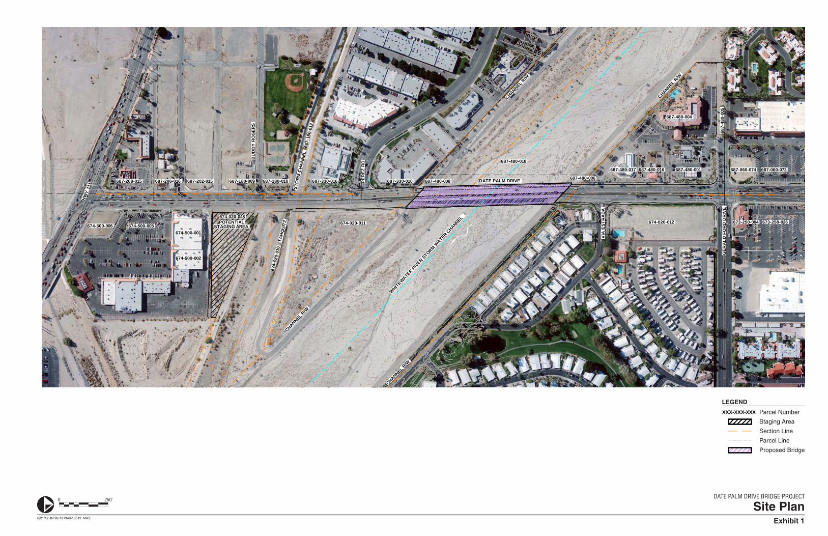
Narrative Location/Route & Postmiles Date Palm Drive Bridge (Bridge Number 56C0189), is located between Perez Road and Gerald Ford Drive. The bridge spans the Whitewater Stormwater Channel, with the project limits from approximately 350 feet south of Perez Road to 250 feet north of Via Estrada within the Cathedral City, Riverside County, State of California. Caltrans Projects – EA# BHLS 5430 (027) (Federal Project Number)
Lead Agency: City of Cathedral City Contact Person Bill Simmons
Hot Spot Pollutant of Concern (check one or both) PM2.5 PM10 X
PM Conformity Hot Spot Analysis – Project Summary for Interagency Consultation
Version 4.0 August 1, 2007
Federal Action for which Project-Level PM Conformity is Needed (check appropriate box)
X Categorical Exclusion (NEPA)
EA or Draft EIS FONSI or
Final EIS PS&E or Construction
Other
Scheduled Date of Federal Action: 2013 NEPA Delegation – Project Type (check appropriate box)
Exempt X Section 6004 –Categorical Exemption Section 6005 – Non-
Categorical Exemption Current Programming Dates (as appropriate) PE/Environmental ENG ROW CON
Start 2010 2010 2010 2014 End 2011 2011 2011 2015
Project Purpose and Need (Summary): Purpose The purpose of the project is to provide congestion relief in order to improve both regional and local traffic flow, as well as improve the safety and operation of the Date Palm Drive Bridge. Need The need for the project relates to structural and operational roadway deficiencies on the Date Palm Drive Bridge. Observations from a site reconnaissance, review of as-built plans, review of bridge inspection reports, and results of conceptual planning studies include structural and operational deficiencies. Structural deficiencies include:
• Spalls and cracks of sever to moderate size and density on the bridge deck • Hairline cracks on concrete pier walls • Exposed pier footings on the riverbed (identified in 2005) • Spalls on deck expansion joints
Operational deficiencies include:
• Inadequate bridge curb-to-curb width, the bridge is narrower than the approach roadway curb-to curb width • No easterly sidewalk • Easterly metal railing is a non-standard feature • No roadway separation between north and southbound traffic • Approach railings misaligned
Surrounding Land Use/Traffic Generators (especially effect on diesel traffic) The proposed project is located within Cathedral City and is immediately surrounded by residential and commercial uses. Diesel truck traffic makes up less than two percent of the total traffic volumes within the project limits. The proposed project would improve the safety and operation of the Date Palm Drive Bridge and provide congestion relief to reduce vehicle queuing and idling, thereby reducing emissions, including those from diesel traffic.
Opening Year: Build and No Build LOS, AADT, % and # trucks, truck AADT of proposed facility The project would provide improvements to the Date Palm Drive Bridge to widen and retrofit improve the bridge and provide highway safety measures. As opening year traffic data is not available, Table 1 (Existing Traffic Volumes), depicts the existing traffic volumes along each segment within the project limits. As shown in Table 1, existing average daily traffic (ADT) volumes range from 13,607 to 20,488, which include truck volumes that range from 76 to 291 ADT. The percentage of trucks along this
PM Conformity Hot Spot Analysis – Project Summary for Interagency Consultation
Version 4.0 August 1, 2007
corridor ranges from 0.56 to 1.71 percent, which is below the national average of eight percent1 and equates to substantially less than 10,000 vehicles.
Table 1 Existing Traffic Volumes
Location Existing
ADT % Trucks # Trucks Date Palm Drive
North of Gerald Ford Drive 17,030 1.71 291 Gerald Ford Drive to Via Estrada 20,488 0.82 168 Via Estrada to Perez Road 19,523 1.33 260 Perez Road to Highway 111 13,607 0.56 76
ADT = Average Daily Traffic Source: RBF Consulting, Date Palm Bridge Replacement Traffic Impact Analysis Report, June 14, 2012.
Table 2 (Existing Level of Service) summarizes the existing delay and corresponding Level of Service (LOS) within the project area. As shown in Table 2, project implementation would improve LOS in the project area.
Table 2 Existing Level of Service
Study Intersection Existing Conditions Existing Plus Project AM
Delay-LOS PM
Delay-LOS AM
Delay-LOS PM
Delay-LOS Date Palm Drive / Gerald Ford Drive 27.3 – C 26.3 – C 21.5 – C 19.5 – B Date Palm Drive / Via Estrada1 11.7 – B 12.7 – B 10.3 – B 10.9 – B Date Palm Drive / Perez Road 16.8 – B 20.1– C 11.8 – B 13.8 – B Date Palm Drive / East Palm Canyon Drive 16.7 – B 14.4 – B 16.7 – B 14.4 – B Deficient intersection operations are shown in bold. Notes: 1. Indicates unsignalized minor street stop controlled intersection. Source: RBF Consulting, Date Palm Bridge Replacement Traffic Impact Analysis Report, June 14, 2012.
RTP Horizon Year / Design Year: Build and No Build LOS, AADT, % and # trucks, truck AADT of proposed facility
The project is a street/bridge improvement project that includes roadway widening, retrofitting, and safety improvements. As the improved roadway cannot serve as a vehicle trip origin or destination, the project does not generate trips. However, traffic volumes are provided for the project area. This section describes the future year (RTP horizon year/design year).
Table 3 (2030 Traffic Volumes) depicts the Horizon Year 2030 traffic volumes along Date Palm Drive. As shown in Table 3, traffic volumes within the project limits are well below 125,000 vehicles daily. The 2006 Guidelines have two criteria to identify a “significant volume of diesel traffic,” which include facilities with greater than 125,000 ADT and eight percent or more of said traffic volumes (i.e., approximately 10,000 vehicles or more). The percentage of trucks along this corridor ranges from 0.56 to 1.71 percent, which is below the national average of eight percent2 and equates to substantially less than 10,000 vehicles.
1 Federal Highway Administration, Highway Statistics 2004, March 2006. 2 Ibid.
PM Conformity Hot Spot Analysis – Project Summary for Interagency Consultation
Version 4.0 August 1, 2007
Table 3 2030 Traffic Volumes
Location Horizon Year (2030)
ADT % Trucks # Trucks Date Palm Drive
North of Gerald Ford Drive 33,300 1.71 569 Gerald Ford Drive to Via Estrada 39,800 0.82 326 Via Estrada to Perez Road 39,800 1.33 529 Perez Road to Highway 111 33,00 0.56 185
ADT = Average Daily Traffic Source: RBF Consulting, Date Palm Bridge Replacement Traffic Impact Analysis Report, June 14, 2012.
Additionally, Table 4 (2030 Level of Service) summarizes the existing and forecast future year 2030 delay and corresponding LOS within the project area. As shown in Table 4, project implementation would improve future LOS in the project area.
Table 4 2030 Level of Service
Study Intersection 2030 Conditions 2030 Plus Project
AM Delay-LOS
PM Delay-LOS
AM Delay-LOS
PM Delay-LOS
Date Palm Drive / Gerald Ford Drive 33.0 – C 37.2 – D 30.5 – C 33.9 – C Date Palm Drive / Via Estrada1 16.2 – C 20.0 – C 12.4 – B 17.1 – C Date Palm Drive / Perez Road 21.6 – C 22.9 – C 16.3 – B 15.6 – B Date Palm Drive / East Palm Canyon Drive 40.7 – D 43.3 – D 40.7 – D 43.3 – D Deficient intersection operations are shown in bold. Notes: 1. Indicates unsignalized minor street stop controlled intersection. Source: RBF Consulting, Date Palm Bridge Replacement Traffic Impact Analysis Report, June 14, 2012.
Opening Year: If facility is an interchange(s) or intersection(s), Build and No Build cross-street AADT, % and # trucks, truck AADT See Above. RTP Horizon Year / Design Year: If facility is an interchange(s) or intersection(s), Build and No Build cross-street AADT, % and # trucks, truck AADT See Above.
Describe potential traffic redistribution effects of congestion relief (impact on other facilities) The proposed project would widen the Date Palm Drive Bridge width from four to six lanes within the existing right-of-way, replace deficient portions of the existing structure, and provide highway safety measures to enhance highway safety and reduce delay. The proposed project would not divert to other routes, and the travel demand volume is not predicted to vary significantly between the build and no-build conditions. Thus, local traffic would not be significantly redistributed.
PM Conformity Hot Spot Analysis – Project Summary for Interagency Consultation
Version 4.0 August 1, 2007
Comments/Explanation/Details (attach additional sheets as necessary) The proposed project would not conflict with an applicable plan, policy, or regulation of an agency with jurisdiction over the project. The proposed project is also consistent with Southern California Association of Governments (SCAG) Regional Transportation Plan (RTP) (RTP ID 3A07028) and Federal Transportation Improvement Program (FTIP) (FTIP ID RIV110501) and is intended to meet the traffic needs in the area based on local land use plans. Per the criteria under 40 CFR 93.123(b)(1), the proposed project does not qualify as project of local air quality concern (POAQC). The proposed project is not a new or expanded highway project that would have a significant number or increase in the number of diesel vehicles. Traffic volumes along Date Palm Road are well below 125,000 vehicles daily and the percentage of trucks along this corridor is less than two percent, which is below the national average of eight percent. The project also would not increase the percentage of heavy trucks in the study area. Therefore, implementation of the proposed project would not cause a significant increase of diesel vehicles (trucks). Based on the information provided above, the proposed project would not introduce significant amounts of diesel truck traffic, would not generate additional diesel truck traffic above levels anticipated without implementation of the project, and is in compliance with the RTP/FTIP. Therefore, the project meets the Clean Air Act requirements and is not a project of air quality concern under 40 CFR 93.123(b)(1).