54
Running the WRF Preprocessing System Michael Duda (as told to Dave Gill) 2007 WRF-NMM Winter Tutorial

Running the WRF PreprocessingSystem
Michael Duda
(as told to Dave Gill)
2007 WRF-NMM Winter Tutorial

2007 WRF-NMM Winter Tutorial 1
Review
Briefly recall the data flow among programs:

2007 WRF-NMM Winter Tutorial 2
Review
geogrid (think geographical)− Define size/location of coarse domain and interpolate
static terrestrial fields to coarse-domain and nested-domain grids
ungrib− Extract meteorological fields from GRIB files
metgrid (think meteorological)− Horizontally interpolate meteorological fields (from
ungrib) to coarse-domain grid (defined by geogrid)

2007 WRF-NMM Winter Tutorial 3
Overview
How to run through the WPS for basic cases− Standard test case with single met. data source− Typical case with multiple met. data sources
Advanced features of the WPS− The GEOGRID.TBL file − Ingesting new static fields− The METGRID.TBL file− “Managing” meteorological fields
WPS utility programs
2007 WRF-NMM Winter Tutorial 4
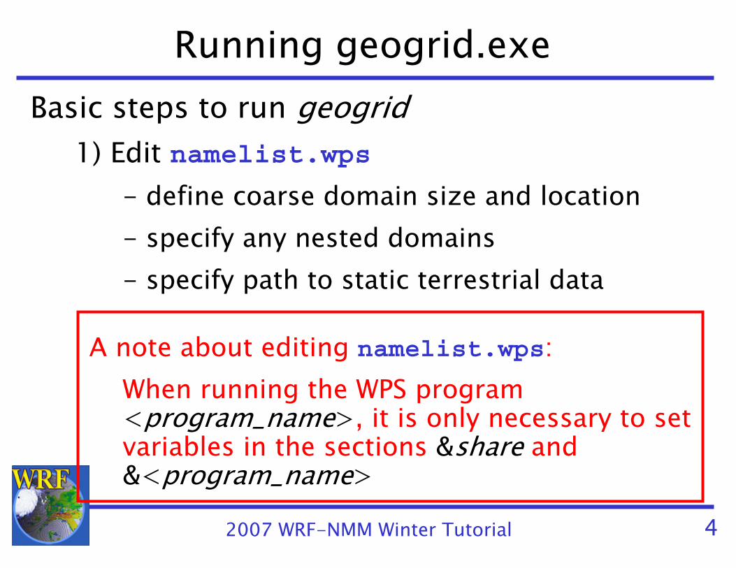
Running geogrid.exeBasic steps to run geogrid
1) Edit namelist.wps- define coarse domain size and location- specify any nested domains- specify path to static terrestrial data
A note about editing namelist.wps:When running the WPS program <program_name>, it is only necessary to set variables in the sections &share and &<program_name>

2007 WRF-NMM Winter Tutorial 5
Running geogrid.exe
2) Run geogrid.exe3) Check geogrid output
- Did geogrid run successfully?!!!!!!!!!!!!!!!!!!!!!!!!!!!!!!!!!!!!!!!!!!!!!
! Successful completion of geogrid. !
!!!!!!!!!!!!!!!!!!!!!!!!!!!!!!!!!!!!!!!!!!!!!
- Do geo_nmm.d01.nc (and possibly geo_nmm_nest.l0?.nc) files exist?
- Does the coarse grid cover the expected domain?

2007 WRF-NMM Winter Tutorial 6
Running geogrid.exe
geogrid
ungrib
metgrid
geo_nmm.d01.ncgeo_nmm_nest.l01.ncgeo_nmm_nest.l02.nc
real.exe
After running geogrid, we should have these files

2007 WRF-NMM Winter Tutorial 7
Running ungrib.exeBasic steps to run ungrib
1) Edit namelist.wps- specify starting and ending time for
simulation- specify interval of available data
2) Link the proper Vtable to the file Vtable3) Link first-guess GRIB files to GRIBFILE.AAA, GRIBFILE.AAB, …
2007 WRF-NMM Winter Tutorial 8
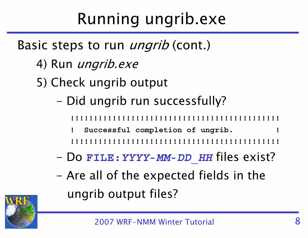
Running ungrib.exeBasic steps to run ungrib (cont.)
4) Run ungrib.exe5) Check ungrib output
- Did ungrib run successfully?!!!!!!!!!!!!!!!!!!!!!!!!!!!!!!!!!!!!!!!!!!!!!
! Successful completion of ungrib. !
!!!!!!!!!!!!!!!!!!!!!!!!!!!!!!!!!!!!!!!!!!!!!
- Do FILE:YYYY-MM-DD_HH files exist?- Are all of the expected fields in the
ungrib output files?

2007 WRF-NMM Winter Tutorial 9
Running ungrib.exe
geogrid
ungrib
metgrid
FILE:2007-07-22_00FILE:2007-07-22_06FILE:2007-07-22_12…
real.exeGRIB files
After running ungrib, we should have files similar to these
geo_nmm.d01.ncgeo_nmm_nest.l01.ncgeo_nmm_nest.l02.nc
2007 WRF-NMM Winter Tutorial 10
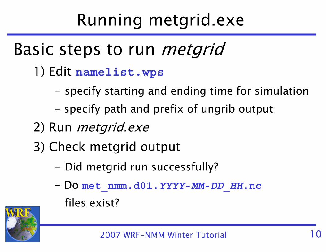
Running metgrid.exeBasic steps to run metgrid
1) Edit namelist.wps- specify starting and ending time for simulation- specify path and prefix of ungrib output
2) Run metgrid.exe3) Check metgrid output
- Did metgrid run successfully?- Do met_nmm.d01.YYYY-MM-DD_HH.nc
files exist?
2007 WRF-NMM Winter Tutorial 11
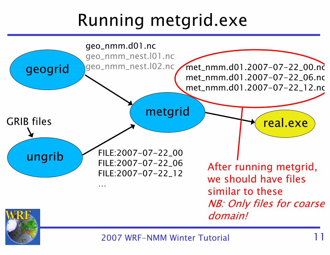
Running metgrid.exe
geogrid
ungrib
metgrid
FILE:2007-07-22_00FILE:2007-07-22_06FILE:2007-07-22_12…
met_nmm.d01.2007-07-22_00.ncmet_nmm.d01.2007-07-22_06.ncmet_nmm.d01.2007-07-22_12.nc
real.exeGRIB files
After running metgrid, we should have files similar to theseNB: Only files for coarse domain!
geo_nmm.d01.ncgeo_nmm_nest.l01.ncgeo_nmm_nest.l02.nc

2007 WRF-NMM Winter Tutorial 12
Running WPS: SummaryThe basic steps to running each WPS program can be summarized as:
− Set variables in the &share and &<program name>
sections in the namelist.wps fileE.g., for metgrid, edit &share and &metgridsections
− For ungrib, link Vtable and GRIBFILE.??? files− Run the program executable− Check that the proper output files exist and
contain good data
2007 WRF-NMM Winter Tutorial 13
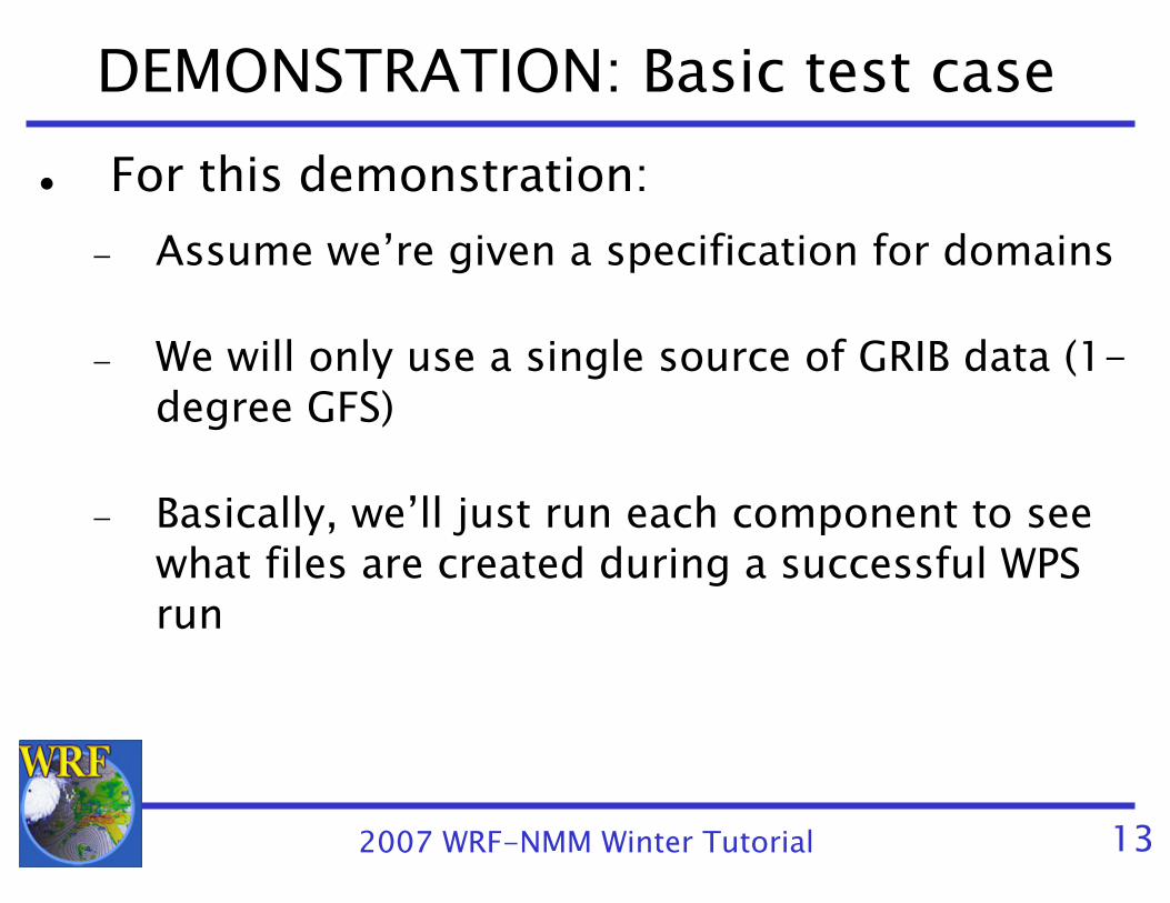
DEMONSTRATION: Basic test caseFor this demonstration:
− Assume we’re given a specification for domains
− We will only use a single source of GRIB data (1-degree GFS)
− Basically, we’ll just run each component to see what files are created during a successful WPS run

2007 WRF-NMM Winter Tutorial 14
DEMONSTRATION: Typical caseWhat new things will we do?
− We need to come up with domain specifications “from scratch”
− The meteorological data come in three pieces: 3-d fields, surface fields, and fixed fields
AWIP data
− We also want to use a separate SST field
2007 WRF-NMM Winter Tutorial 15
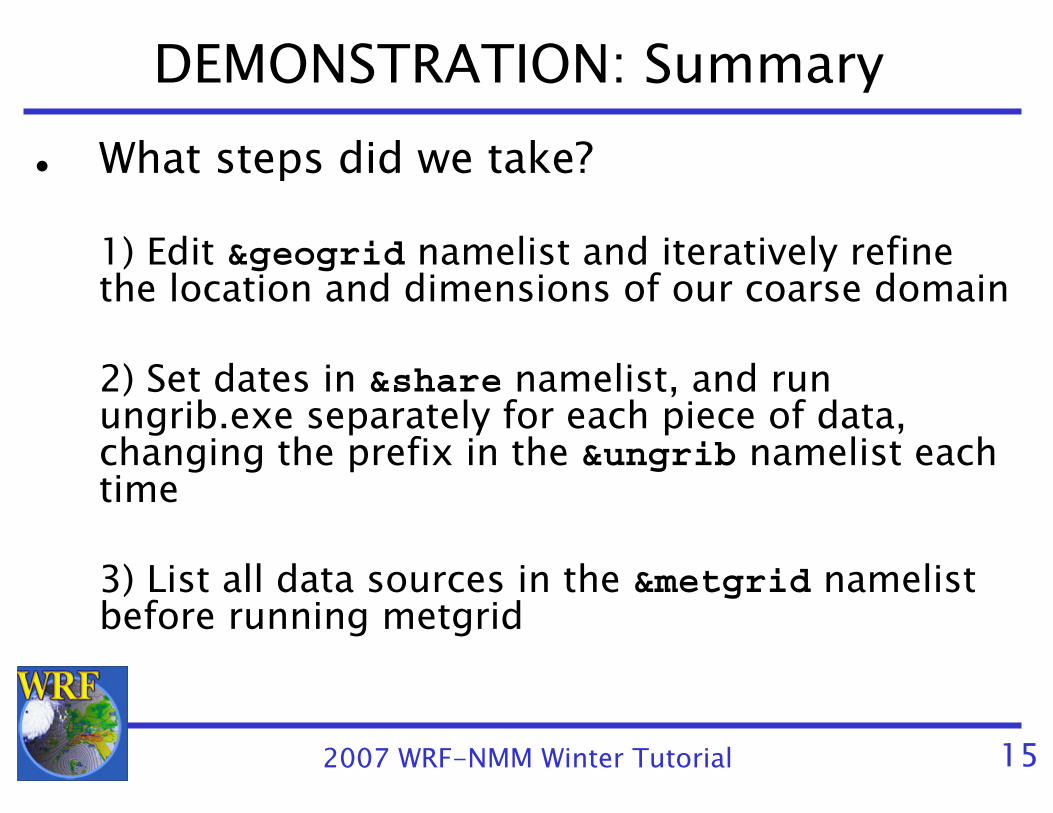
DEMONSTRATION: SummaryWhat steps did we take?
1) Edit &geogrid namelist and iteratively refine the location and dimensions of our coarse domain
2) Set dates in &share namelist, and run ungrib.exe separately for each piece of data, changing the prefix in the &ungrib namelist each time
3) List all data sources in the &metgrid namelistbefore running metgrid

2007 WRF-NMM Winter Tutorial 16
Overview
How to run through the WPS for basic cases− Standard test case with single met. data source− Typical case with multiple met. data sources
Advanced features/use of the WPS− The GEOGRID.TBL file − Ingesting new static fields in geogrid− The METGRID.TBL file− “Working with” meteorological fields in metgrid
WPS utility programs

2007 WRF-NMM Winter Tutorial 17
The GEOGRID.TBL File
GEOGRID.TBL is the file that determines which fields are interpolated by geogrid
− Generally, user will want all of the default fields, so few reasons to edit GEOGRID.TBL
− When new data sources are involved, or when the default treatment of fields is inadequate, user will want to edit GEOGRID.TBL
− Each entry in GEOGRID.TBL corresponds to one data source

2007 WRF-NMM Winter Tutorial 18
Example: GEOGRID.TBL Entries===============================name = VEG_CATEGORY
priority = 1dominant_only = VEG_CATdest_type = categoricalz_dim_name = veg_catinterp_option = default:nearest_neighborabs_path = default:/data/duda/MODIS/
===============================name = SOILCTOP
dominant = SOILCATpriority = 1dest_type = categoricalz_dim_name = soil_catinterp_option = 2m:sixteen_ptinterp_option = 10m:sixteen_ptrel_path= 2m:soiltype_top_2m/rel_path= 10m:soiltype_top_10m/
===============================
Entry for the field“VEG_CATEGORY”
Entry for the field“SOILCTOP”

2007 WRF-NMM Winter Tutorial 19
New Field in GEOGRID.TBLThere are three basic types of new data to be added through the GEOGRID.TBL file:
1) Completely new fields- fields that were previously not processed by
geogrid
2) Different resolution data sets for an existing field
- e.g., Adding a 100-meter resolution topography data set
3) Alternative sources for a field that must be used in addition to an existing source
- e.g., A new soil category data set exists, but covers only southern Colorado

2007 WRF-NMM Winter Tutorial 20
GEOGRID.TBL: Data Type 1Completely new fields:
For a new field, simply add an entry in GEOGRID.TBL for that field.
===============================name = MY_NEW_FIELD_NAME
priority = 1dest_type = continuous # continuous or categorical?
interp_option = four_ptabs_path = /data/duda/mydata/
===============================

2007 WRF-NMM Winter Tutorial 21
GEOGRID.TBL: Data Type 2Different resolution data sets for an existing field :
Specify the path to the new data set and whichinterpolation methods should be used for the newresolution in the existing entry for that field.===============================name = HGT_Mpriority = 1dest_type = continuoussmooth_option = smth-desmthinterp_option = 30s:special(4.0)+four_ptinterp_option = my_res:four_ptinterp_option = default:four_ptrel_path = 30s:topo_30s/rel_path = my_res:new_topo_directory/rel_path = default:topo_2m/
===============================
2007 WRF-ARW Winter Tutorial 22
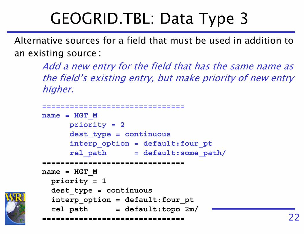
GEOGRID.TBL: Data Type 3Alternative sources for a field that must be used in addition toan existing source :
Add a new entry for the field that has the same name as the field’s existing entry, but make priority of new entry higher.===============================name = HGT_M
priority = 2dest_type = continuousinterp_option = default:four_ptrel_path = default:some_path/
===============================name = HGT_Mpriority = 1dest_type = continuousinterp_option = default:four_ptrel_path = default:topo_2m/
===============================

2007 WRF-NMM Winter Tutorial 23
Ingesting new static fieldsTo add a new data source, need to
1) Write the data in the proper binary format- See Chapter 3: “Writing Static Data to the GeogridBinary Format”
2) Create an “index” metadata file to define projection anddimensions of data
3) Add entry for the data in the GEOGRID.TBL file
4) Run geogrid.exe

2007 WRF-NMM Winter Tutorial 24
Example: Houston LU Data SetGiven dataset for new Houston urban land use categories
− Regular lat/lon projection, 30” resolution; categories 31, 32 & 33
Urban areas (black) using USGS 24-category data set
Area of Houston data tile in relation to model domain; white=missing
data and blue=valid data

2007 WRF-NMM Winter Tutorial 25
Example: Houston LU Data SetTo make use of the new data, we do the following:1) Write the data to the binary format used by geogrid2) Create an index file for the data
type=categoricalcategory_min=31; category_max=33projection=regular_lldx=0.00833333; dy=0.00833333known_x=1.0; known_y=1.0known_lat=29.3375known_lon=-95.9958333wordsize=1tile_x=157; tile_y=143; tile_z=1missing_value = 0.units="category"description="3-category urban LU"

2007 WRF-NMM Winter Tutorial 26
3) Define an entry for the data in GEOGRID.TBL
===============================name=LANDUSEF
priority = 2dest_type = categoricalz_dim_name = land_catinterp_option = default:nearest_neighborabs_path = default:/users/duda/Houston/
===============================
Example: Houston LU Data Set

2007 WRF-NMM Winter Tutorial 27
Example: Houston LU Data Set4) Run geogrid.exe
Any gridpoints covered by Houston data will use it; otherwise default USGS data will be used
Urban areas (black) using USGS 24-category data set
Augmented urban areas (red shades) using new LU data set

2007 WRF-NMM Winter Tutorial 28
The METGRID.TBL FileThe METGRID.TBL file controls how time-varying
fields are interpolated Unlike GEOGRID.TBL, METGRID.TBL does not determine which fields will be processed, only how to process themEvery field in intermediate files will be interpolated
− If no entry in METGRID.TBL for a field, a default interpolation scheme (nearest neighbor) will be used

2007 WRF-NMM Winter Tutorial 29
The METGRID.TBL FileSuitable entries in METGRID.TBL are provided for common fields
− Thus, many users will rarely need to edit METGRID.TBL
When necessary, different interpolation methods (and other options) can be set in METGRID.TBL
− Interpolation options can depend on the source of a field

2007 WRF-NMM Winter Tutorial 30
Ingesting New Fields in MetgridSuppose we have a 1000x1000 domain over Houston (dx=500 m)
− This is the same domain as in the urban land use example
Meteorological data come from 1-degree GFS− Note that we will be interpolating 1-degree data onto a
500-m grid!
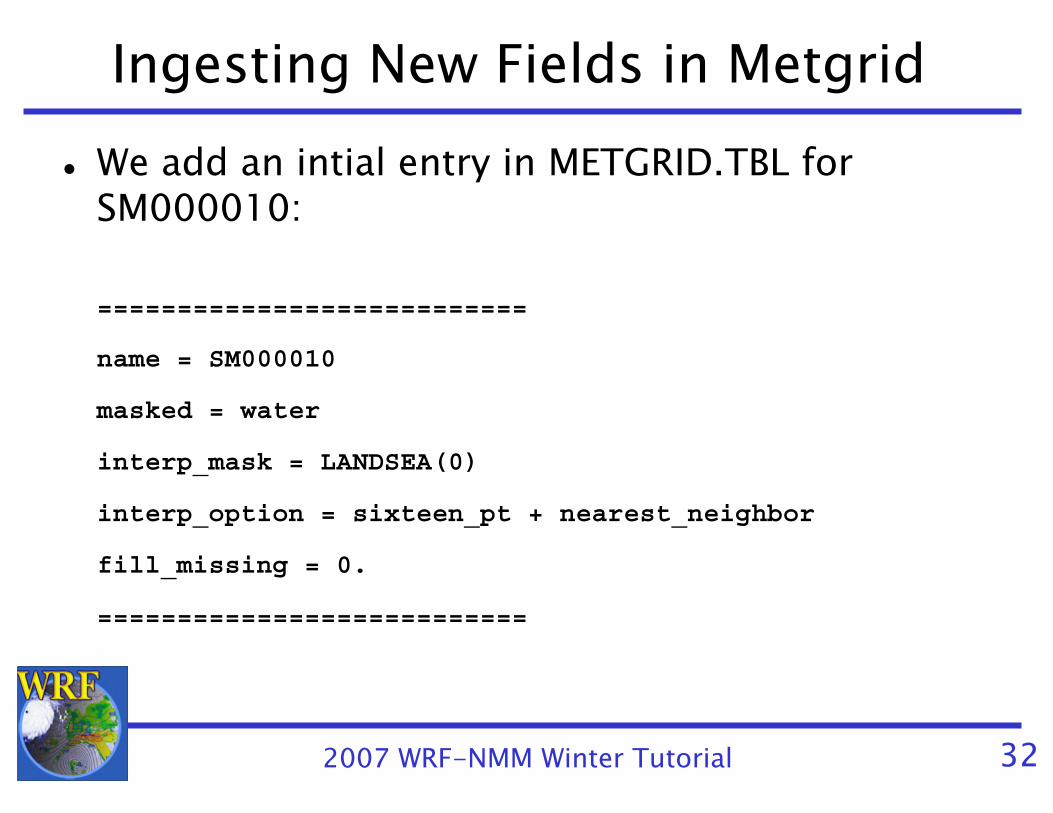
Also suppose that there is no METGRID.TBL entry for some new soil moisture field, SM000010

2007 WRF-NMM Winter Tutorial 31
Ingesting New Fields in MetgridInitially, run metgrid.exe and get the message:
INFORM: Entry in METGRID.TBL not found for field SM000010. Default options will be used for this field!
Resulting field looks like
GFS puts -1E30 in water areas (LANDSEA=0)
2007 WRF-NMM Winter Tutorial 32
Ingesting New Fields in MetgridWe add an intial entry in METGRID.TBL for SM000010:
===========================
name = SM000010
masked = water
interp_mask = LANDSEA(0)
interp_option = sixteen_pt + nearest_neighbor
fill_missing = 0.
===========================

2007 WRF-NMM Winter Tutorial 33
Ingesting New Fields in MetgridRunning metgrid.exe again, the SM000010 field now looks like
Interpolated SM000010 field(sixteen_pt + nearest_neighbor)
Which interpolator was used at eachmodel grid point
NearestNeighbor
16-point
2007 WRF-NMM Winter Tutorial 34
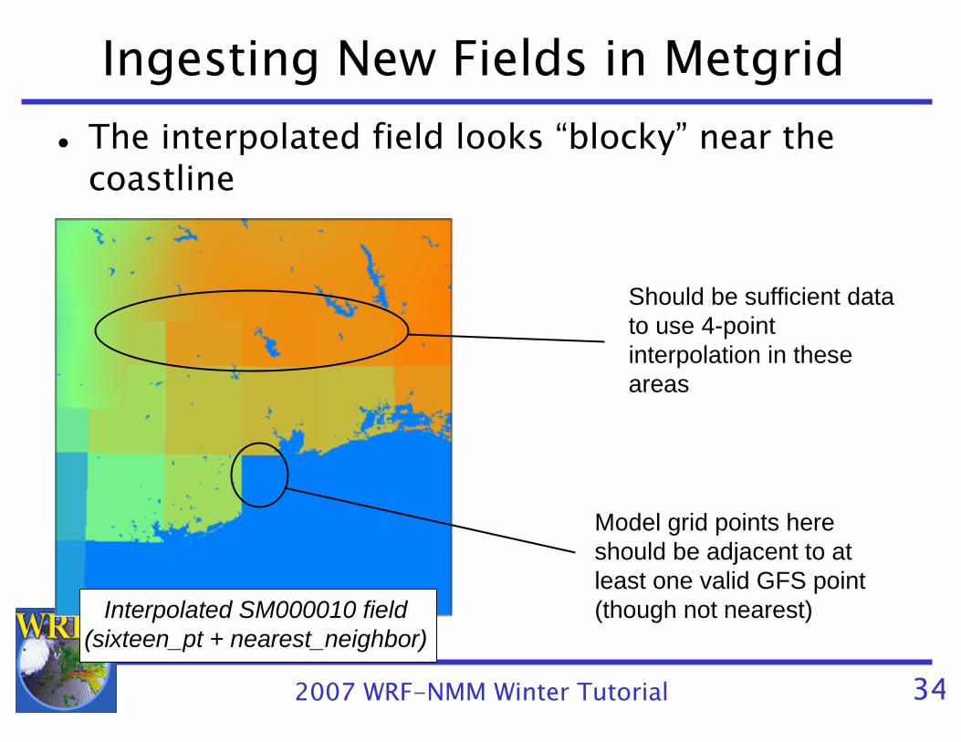
Ingesting New Fields in MetgridThe interpolated field looks “blocky” near the coastline
Should be sufficient data to use 4-point interpolation in these areas
Model grid points here should be adjacent to at least one valid GFS point (though not nearest)Interpolated SM000010 field
(sixteen_pt + nearest_neighbor)

2007 WRF-NMM Winter Tutorial 35
Ingesting New Fields in MetgridUpdate the METGRID.TBL entry for SM000010===========================
name = SM000010
masked = water
interp_mask = LANDSEA(0)
interp_option = sixteen_pt + four_pt + average_4pt
fill_missing = 0.
===========================
If 16-pt doesn’t work, then try 4-pt before using a 4-point average
− Note that 4-point average will work anywhere nearest_neighborwould (missing/masked values not counted in the average)

2007 WRF-NMM Winter Tutorial 36
Ingesting New Fields in MetgridThe resulting field, below-left:
Which interpolator was used at eachmodel grid point
NearestNeighbor
16-point16-point
4-point
4-pt average
Interpolated SM000010 field(sixteen_pt + four_pt + average_4pt)

2007 WRF-NMM Winter Tutorial 37
Ingesting New Fields in MetgridBy using wt_average_4pt instead of average_4pt:
sixteen_pt + four_pt + wt_average_4ptsixteen_pt + four_pt + average_4pt
NB: The figures above are from a different time from previous slides!

2007 WRF-NMM Winter Tutorial 38
METGRID.TBL: Real-time System Example
Suppose we have a real-time system that:− Uses GFS for initial and boundary conditions− When possible (i.e., if the files are available soon
enough) uses soil moisture and soil temperature fields from AGRMET
In our system, it may occasionally happen that the AGRMET files are not ready when we want to start our WRF run
− Because system is real-time, we want to proceed using just the GFS land surface fields!

2007 WRF-NMM Winter Tutorial 39
METGRID.TBL: Real-time System Example
We already know how to run ungrib on multiple sources of data to getGFS:YYYY-MM-DD_HHandAGRMET:YYYY-MM-DD_HHintermediate files, and specify fg_name = ‘GFS’, ’AGRMET’,in the &metgrid namelist record to use both files

2007 WRF-NMM Winter Tutorial 40
METGRID.TBL: Real-time System Example
Without further changes, what happens if:1) Only GFS data are available when we run metgrid
- Metgrid runs and warns that no AGRMET data files were found:
Processing 2006-04-01_00GFSAGRMET
WARNING: Couldn't open file AGRMET:2006-04-01_00 for input.

2007 WRF-NMM Winter Tutorial 41
METGRID.TBL: Real-time System Example
And the 0-10 cm soil moisture field (SM000010) looks like:
2007 WRF-NMM Winter Tutorial 42
METGRID.TBL: Real-time System Example
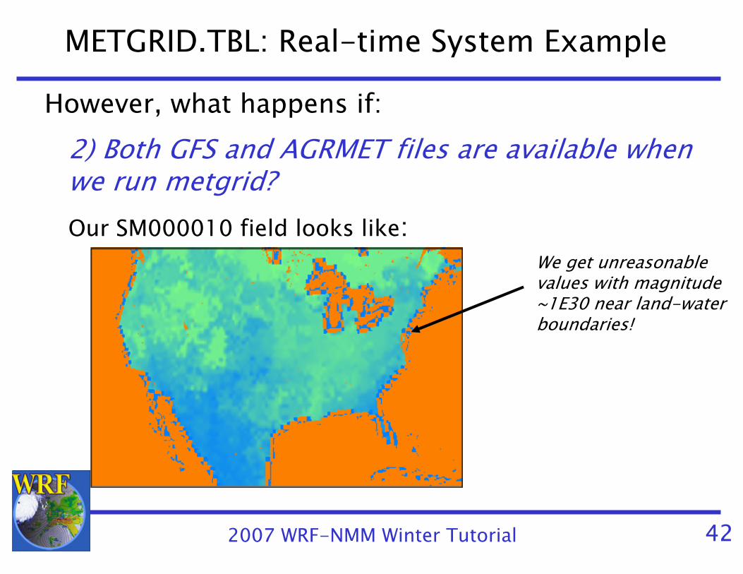
However, what happens if:2) Both GFS and AGRMET files are available when we run metgrid?Our SM000010 field looks like:
We get unreasonable values with magnitude ~1E30 near land-water boundaries!

2007 WRF-NMM Winter Tutorial 43
METGRID.TBL: Real-time System Example
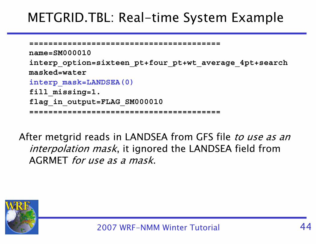
What went wrong?In both Vtable.GFS and Vtable.AGRMET, the land-sea
mask field is named LANDSEA- In METGRID.TBL, our entry for SM000010 says:========================================name=SM000010 interp_option=sixteen_pt+four_pt+wt_average_4pt+searchmasked=waterinterp_mask=LANDSEA(0)fill_missing=1.flag_in_output=FLAG_SM000010========================================
2007 WRF-NMM Winter Tutorial 44
METGRID.TBL: Real-time System Example========================================name=SM000010 interp_option=sixteen_pt+four_pt+wt_average_4pt+searchmasked=waterinterp_mask=LANDSEA(0)fill_missing=1.flag_in_output=FLAG_SM000010========================================
After metgrid reads in LANDSEA from GFS file to use as an interpolation mask, it ignored the LANDSEA field from AGRMET for use as a mask.
2007 WRF-NMM Winter Tutorial 45
METGRID.TBL: Real-time System Example
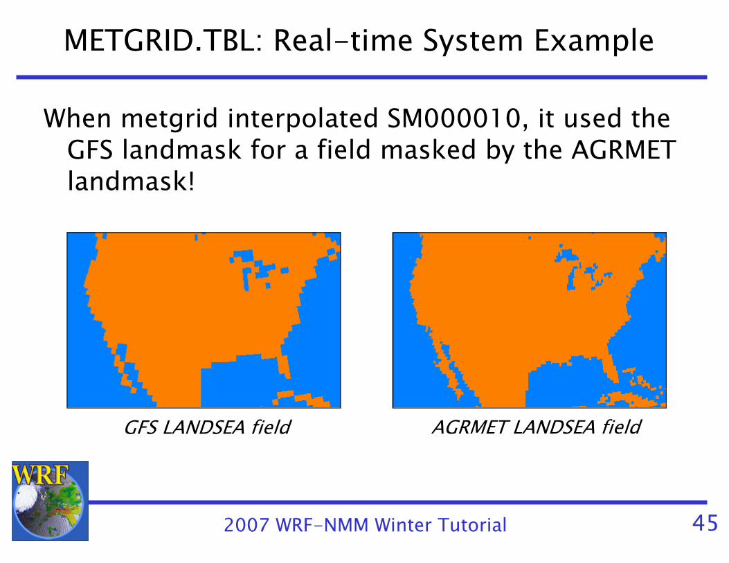
When metgrid interpolated SM000010, it used the GFS landmask for a field masked by the AGRMET landmask!
GFS LANDSEA field AGRMET LANDSEA field

2007 WRF-NMM Winter Tutorial 46
METGRID.TBL: Real-time System Example
Solution:- Rename LANDSEA to AGR_LAND in Vtable.AGRMET
- Rename LANDSEA to GFS_LAND in Vtable.GFS
- Create separate entries in METGRID.TBLone for GFS SM000010 fieldanother for AGRMET SM000010 field

2007 WRF-NMM Winter Tutorial 47
METGRID.TBL: Real-time System Example
========================================name=SM000010; from_input=GFS interp_option=sixteen_pt+four_pt+wt_average_4pt+searchmasked=waterinterp_mask=GFS_LAND(0)fill_missing=1.flag_in_output=FLAG_SM000010========================================
========================================name=SM000010; from_input=AGRMET interp_option=sixteen_pt+four_pt+wt_average_4pt+searchmasked=waterinterp_mask=AGR_LAND(-1.E30)fill_missing=1.flag_in_output=FLAG_SM000010========================================

2007 WRF-NMM Winter Tutorial 48
METGRID.TBL: Real-time System Example
With modified Vtables and METGRID.TBL:
The SM000010 field when only GFS files are available
The SM000010 field when both GFS and AGRMET files are available

2007 WRF-NMM Winter Tutorial 49
WPS Utility Programs
The utility programs that come with WPS can be helpful when diagnosing problems with WPS output- Users are encouraged to make use of these utilities to examine WPS input and output files
LIVE DEMONSTRATION OF UTILITIES
2007 WRF-NMM Winter Tutorial 50
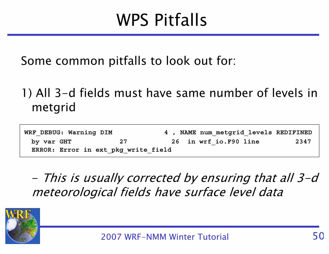
WPS Pitfalls
Some common pitfalls to look out for:
1) All 3-d fields must have same number of levels in metgrid
WRF_DEBUG: Warning DIM 4 , NAME num_metgrid_levels REDIFINED
by var GHT 27 26 in wrf_io.F90 line 2347ERROR: Error in ext_pkg_write_field
- This is usually corrected by ensuring that all 3-d meteorological fields have surface level data
2007 WRF-NMM Winter Tutorial 51
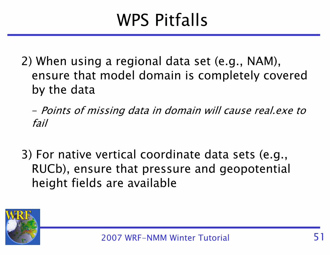
WPS Pitfalls
2) When using a regional data set (e.g., NAM), ensure that model domain is completely covered by the data- Points of missing data in domain will cause real.exe to fail
3) For native vertical coordinate data sets (e.g., RUCb), ensure that pressure and geopotentialheight fields are available
2007 WRF-NMM Winter Tutorial 52
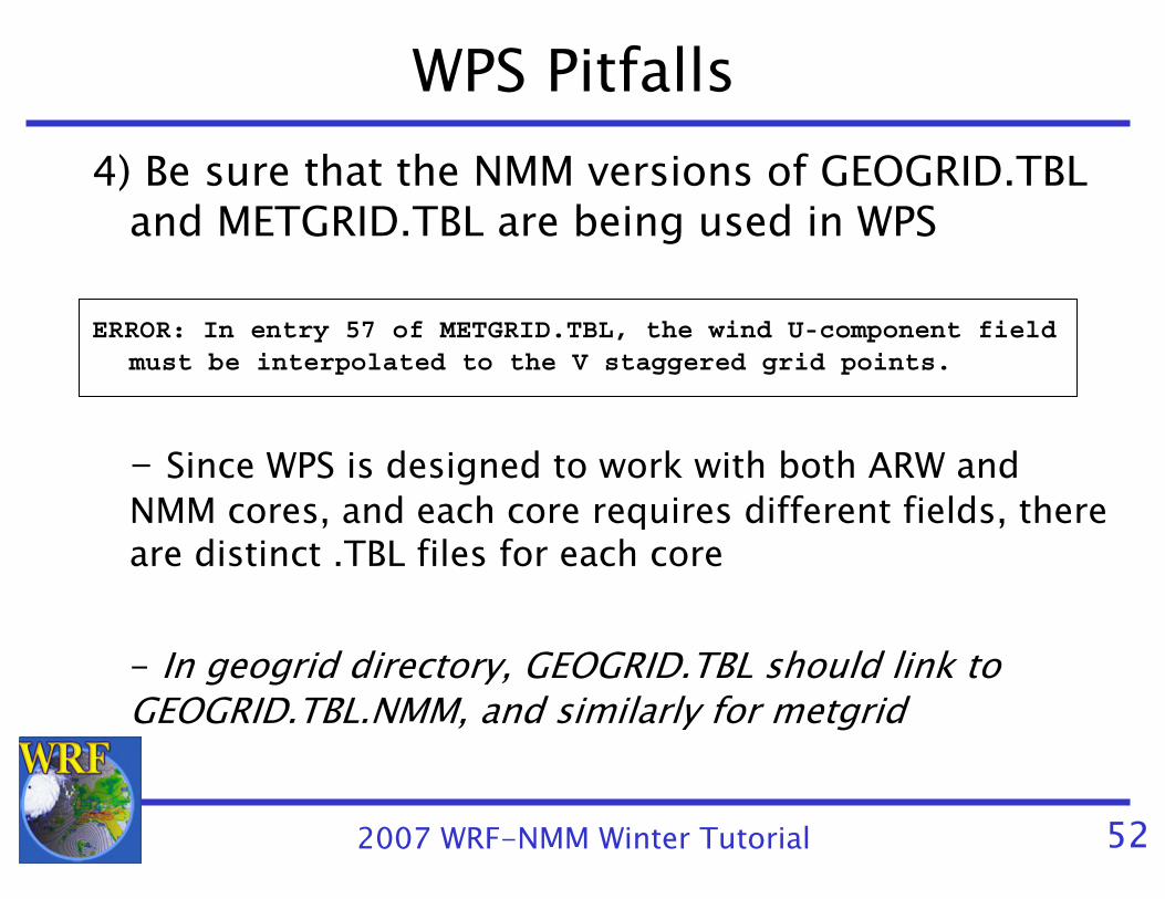
WPS Pitfalls4) Be sure that the NMM versions of GEOGRID.TBL
and METGRID.TBL are being used in WPS
ERROR: In entry 57 of METGRID.TBL, the wind U-component field must be interpolated to the V staggered grid points.
- Since WPS is designed to work with both ARW and NMM cores, and each core requires different fields, there are distinct .TBL files for each core
- In geogrid directory, GEOGRID.TBL should link to GEOGRID.TBL.NMM, and similarly for metgrid

2007 WRF-NMM Winter Tutorial 53
Questions?


