29
April 2018 Runnymede 2030 Site Capacity Analysis Addendum

April 2018
Runnymede 2030Site Capacity AnalysisAddendum


Contents
1. Introduction .................................................................................................................... 3
2. Housing Sites Update .................................................................................................... 4
Site 60 – Pyrcroft Road, Chertsey.................................................................................. 4
Site 156 – Blay’s House, Blay’s Lane, Englefield Green................................................. 7
Site 255A – Parcel A, Chertsey Bittams, (Green Lane) ................................................ 10
Site 256 – Parcel A, Thorpe Lea Road North (Thorpe Lea Manor) ............................... 13
Site 257– Thorpe Lea Road (West).............................................................................. 15
Site 258 – Virginia Water (North) ................................................................................. 18
Site 261 – Virginia Water (South)................................................................................. 22
Site 263 – Ottershaw East ........................................................................................... 24
3. Site Summaries (all sites) ............................................................................................ 27
Table 2-1: Capacity Scenarios for site 60 – Pyrcroft Road, Chertsey ............................. 4
Table 2-2: Capacity Scenarios for site 60 – Pyrcroft Road, Chertsey (Chilsey GreenFarm Only)..................................................................................................................... 5
Table 2-3: Capacity Scenarios for site 156 Blay’s House, Blay’s Lane, Englefield Green7
Table 2-4: Capacity Scenarios for site 255A Parcel A, Chertsey Bittams (with AQMA) 11
Table 2-5: Capacity Scenarios for site 255A Parcel A, Chertsey Bittams (without AQMA).................................................................................................................................... 11
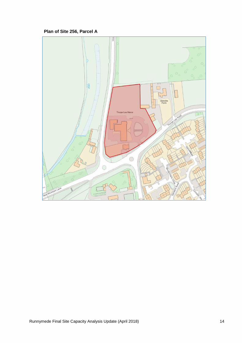
Table 2-6: Capacity Scenarios for site 256 Thorpe Lea Road North, Parcel A ............. 13
Table 2-7: Capacity Scenarios for site 257, Thorpe Lea Road West (with AQMA) ....... 15
Table 2-8: Capacity Scenarios for site 257, Thorpe Lea Road West (without AQMA)... 16
Table 2-9: Capacity for Site 258, Merlewood................................................................ 19
Table 2-10: Capacity for Site 258, Kenwolde (dwellings retained)................................ 20
Table 2-11: Capacity for Kenwolde (whole site) ........................................................... 20
Table 2-12: Capacity Scenarios for site 261 Virginia Water South ............................... 22
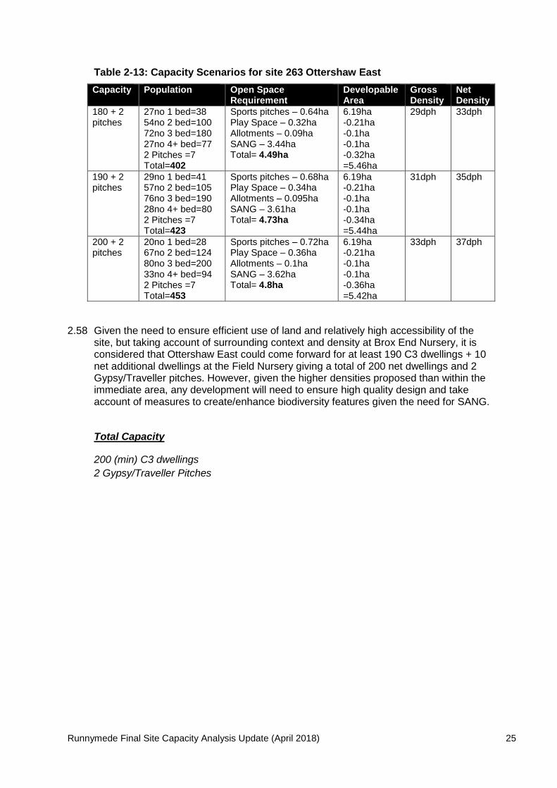
Table 2-13: Capacity Scenarios for site 263 Ottershaw East........................................ 25

Runnymede Final Site Capacity Analysis Update (April 2018) 3
1. Introduction
1.1 This Final Capacity Analysis Addendum Report reconsiders the capacity for a numberof the proposed sites for allocation in the Local Plan following updates to constraints,responses to the draft Local Plan consultation where considered appropriate andfurther site visits and discussions with site promoters and land owners.
1.2 The purposes of this Addendum report is not to re-visit every site or the basicassumptions used in the Final Capacity Report of December 2017 and as such,assumptions such as housing mix, dwelling size and occupation rates have remainedthe same as has the methodology for determining capacity.
1.3 Where capacities have been revised these have fed into the Local Plan Modificationsand Sustainability Appraisal which will themselves be subject to further consultation in2018.

Runnymede Final Site Capacity Analysis Update (April 2018) 4
2. Housing Sites Update
Site 60 – Pyrcroft Road, Chertsey
2.1 The site at Pyrcroft Road lies on the western edge of Chertsey, north of the rail lineand south of Pyrcroft Road. Part of the site is currently designated as a reservehousing site in the current Local Plan 2001 but is planned to be extended to include anadditional parcel to the south west and Grange Farm.
2.2 Site is 8.95ha in area. However, 1.43ha of the site is constrained by either functionalfloodplain or flood zone 3a. To avoid having to pass the exceptions test for residentialdevelopment in zone 3a, this area could be used for the provision of greeninfrastructure and Sustainable Drainage Systems (SuDS) therefore limiting the loss ofcapacity on site and reducing/mitigating flood risks. Given the additional land availablefor this site as opposed to the reserve site, the narrowing of the gap in the site due toflood risk is no longer a factor affecting capacity. Flood zone 2 also covers part of thesite but this is not considered to be a barrier to capacity in the same way as flood zone3. The site is large enough to provide Gypsy & Traveller pitches, and assessing thesite qualitatively there could be potential for 5 pitches.
2.3 There is also an existing 63 bed nursing/residential care home (The GrangeRetirement Home) on site which would be expected to be retained or replaced withsimilar. The land take of the existing nursing/residential care home and its associatedcar parking/landscaping/amenity is around 0.25ha which has been netted off thedevelopable area.
2.4 Surrounding net density ranges from 30-51dph and as such a range of capacities havebeen tested whilst applying standards and assumptions for Gypsy/Traveller pitchesand green infrastructure as set out in Table 3-3. However, given the need to makeefficient use of land, the site’s relatively high level of accessibility and the amount ofland lost to accommodate flood risk zone 3a, net densities lower than 40dph have notbeen considered.
Table 2-1: Capacity Scenarios for site 60 – Pyrcroft Road, Chertsey
Capacity Population Open SpaceRequirement
DevelopableArea
GrossDensity
NetDensity
250 + 5pitches
26no 1 bed=3684no 2 bed=15599no 3 bed=24841no 4+bed=1175 pitches = 18Total=574
Sports pitches – 0.92haPlay Space – 0.46haAllotments – 0.128haSANG – Delivered off siteTotal= 1.508ha
8.95ha-1.508ha-0.25ha-0.25ha=6.94ha
28dph 36dph
275 + 5pitches
28no 1 bed=3992no 2 bed=170109no 3 bed=27346no 4+bed=1315 pitches = 18Total=631
Sports pitches – 1haPlay Space – 0.5haAllotments – 0.14haSANG – Delivered off siteTotal= 1.64ha
8.95ha-1.64ha-0.25ha-0.25ha=6.81ha
31dph 41dph
300 + 5pitches
29no 1 bed=41101no 2 bed=187120no 3 bed=30050no 4+bed=1435 pitches = 18Total=689
Sports pitches – 1.1haPlay Space – 0.55haAllotments – 0.153haSANG – Delivered off siteTotal= 1.8ha
8.95ha-1.8ha-0.25ha-0.25ha=6.65ha
34dph 46dph
Runnymede Final Site Capacity Analysis Update (April 2018) 5
2.5 It is considered that site 60 could provide between 275-300 dwellings as well as 5Gypsy/Traveller pitches and retention of the C2 use at The Grange Nursing Home.Given that areas of development would be sited within flood risk zone 2, developmentfor housing on those parts of the site would need to pass the sequential test. Further,the requirement for potential flood alleviation measures may also increase land takefor green infrastructure to form appropriate SuDS mitigation and therefore reducecapacity to the lower end of the capacity range. Nevertheless, given the high density ofdevelopment it will need to achieve a high quality design appropriate to its context.
2.6 If the site were to come forward in two parcels (Chilsey Green Farm and GrangeFarm/St Ann’s Lodge), the level of development considered appropriate for ChilseyGreen Farm alone is set out in Table 2-2.
Table 2-2: Capacity Scenarios for site 60 – Pyrcroft Road, Chertsey (ChilseyGreen Farm Only)
Capacity Population Open SpaceRequirement
DevelopableArea
GrossDensity
NetDensity
150 + 5pitches
16no 1 bed=2250no 2 bed=9360no 3 bed=15024no 4+ bed=685 pitches = 18Total=351
Sports pitches – 0.56haPlay Space – 0.28haAllotments – 0.078haSANG – Delivered off siteTotal= 0.92ha
6.27ha-1.43ha-0.25ha=4.59ha
24dph 34dph
175 + 5pitches
19no 1 bed=2758no 2 bed=10769no 3 bed=17329no 4+ bed=835 pitches = 18Total=408
Sports pitches – 0.65haPlay Space – 0.32haAllotments – 0.09haSANG – Delivered off siteTotal= 1.06ha
6.27ha-1.43ha-0.25ha=4.59ha
29dph 39dph
200 + 5pitches
20no 1 bed=2867no 2 bed=12480no 3 bed=20033no 4+ bed=945 pitches = 18Total=464
Sports pitches – 0.74haPlay Space – 0.37haAllotments – 0.1haSANG – Delivered off siteTotal= 1.21ha
6.27ha-1.43ha-0.25ha=4.59ha
33dph 45dph
2.7 It is considered that Chilsey Green Farm alone could provide between 175 and 200dwellings as well as 5 Gypsy/Traveller pitches. The site at Grange Farm/St Ann’slodge would provide the remainder of development of 75-100 C3 dwellings on 2.09haand net density between 36-48dph.
Total Capacity
275 (min) C3 residential dwellings
5 Gypsy/Traveller Pitches
Runnymede Final Site Capacity Analysis Update (April 2018) 6
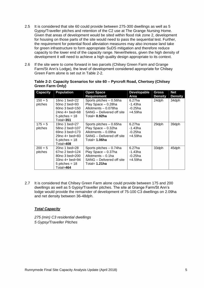
Plan of Site 60
Runnymede Final Site Capacity Analysis Update (April 2018) 7
Site 156 – Blay’s House, Blay’s Lane, Englefield Green
2.8 Site is 3.56ha comprising office accommodation and locally listed building at ParkHouse and lies to the south of Englefield Green adjacent to a former housing reservesite which is now under construction. The site is not considered large enough toprovide Gypsy/Traveller pitches or C2/Sheltered accommodation. There are noconstraints on site but the SNCI and Historic Park and Garden at Windsor Great Parklie opposite and therefore a buffer along the frontage of the site formed from existingvegetation could be retained to mitigate any impact. This buffer would be around 0.4hain area.
2.9 Park House, a locally listed building lies on the western boundary of the site and hasrecently been granted permission for conversion from offices to 8 residentialapartments. Whilst space exists around Park House for additional development thismay affect the setting of the locally listed building and as such the land in theimmediate vicinity of Park House may not be suitable for residential development.Further, an ordinary water course is located on site and development should notencroach within 8m of this feature, although part of this falls within a potential bufferarea as stated above.
2.10 TPO 419 is also located on site with an approximate area outside of the SNCI bufferand water course of around 0.23ha.
2.11 The water course, SNCI buffer and TPO combined reduce the developable area byaround 0.83ha some of which lies close to the locally listed Park House which offersonly limited opportunity for further development around the locally listed building. Afurther 0.28ha has therefore been netted off to account for Park House and itssurrounds.
2.12 The former housing reserve site at Wick Road is currently being constructed to a grossdensity of around 32dph and net density of around 43dph. Residential development tothe north has a net density ranging between 38-45dph. Given the need to make themost efficient use of land and giving consideration to surrounding density and contextcapacities with net density less than 35dph have not been considered.
2.13 Applying the assumptions for green infrastructure requirements give the capacityranges as set out in Table 2-3. Whilst the site may not be large enough toaccommodate sports pitches, it could swap this requirement for another greeninfrastructure typology.
Table 2-3: Capacity Scenarios for site 156 Blay’s House, Blay’s Lane, EnglefieldGreen
Capacity Population Open SpaceRequirement
DevelopableArea
GrossDensity
NetDensity
80 9no 1 bed=1327no 2 bed=5031no 3 bed=7813no 4+ bed=37Total=178
Sports pitches – off-sitePlay Space – 0.14haAllotments – off-siteSANG – Delivered off siteTotal= 0.14ha
3.56ha-0.83ha-0.28ha-0.14ha=2.31ha
22dph 34dph
90 9no 1 bed=1330no 2 bed=5636no 3 bed=9015no 4+ bed=43Total=202
Sports pitches – off-sitePlay Space – 0.16haAllotments – off-siteSANG – Delivered off siteTotal= 0.16ha
3.56ha-0.83ha-0.28ha-0.16ha=2.29ha
25dph 39dph
100 10no 1 bed=1434no 2 bed=6340no 3 bed=100
Sports pitches – off-sitePlay Space – 0.18haAllotments – off-site
3.56ha-0.83ha-0.28ha
28dph 44dph

Runnymede Final Site Capacity Analysis Update (April 2018) 8
16no 4+ bed=46Total=223
SANG – Delivered off siteTotal= 0.18ha
-0.18ha=2.27ha
2.14 Given the density of the development already permitted on the adjacent former reservehousing site and density to the north, as well as the sites modest level of accessibilityand the existing permission at Park House, it is considered that site 156 could comeforward for around 100 C3 dwellings. However, given the higher densities proposed,any development will need to be of a high quality design and appropriate to its context.
Total Capacity
100 (min) C3 residential dwellings

Runnymede Final Site Capacity Analysis Update (April 2018) 9
Plan of Site 156

Runnymede Final Site Capacity Analysis Update (April 2018) 10
Site 255A – Parcel A, Chertsey Bittams, (Green Lane)
2.15 Parcel A is comprised of land between Green Lane and west/southwest of the M25.The site is 7ha in area. The site is large enough to provide Gypsy/Traveller pitcheswith a separate access point and 5 pitches at 0.25ha could be accommodated.However it is not considered that the site could also provide C2 or sheltered units andthe sites proximity to the M25 may not make it appropriate for more sensitivereceptors. 1.8ha of the site also lies within the AQMA for the M25 and as such, thedevelopability of this area will depend on a site level air and noise quality assessment.However, areas of the AQMA could form some areas of green infrastructure or acommunity hub building on site and as such the area of land in the AQMA has beennetted off by the amount of land required by the community hub building (0.1ha) butnot equipped playing space. Should air/noise quality determine that impacts from theM25 are not a factor affecting developability then the capacity of the site couldincrease and an indication of site capacity if air/noise quality is not a factor has beenset out.
2.16 A small area of the site (0.07ha) is located within flood zone 3a where the sequentialand exceptions test would need to be passed before development could be consideredacceptable. However, this area could form part of private or public amenity space andbe avoided. A further 0.3ha of the site is within flood zone 2, however, this is notconsidered to be a barrier to development and in any event, as for flood zone 3a, thiscould be located within green infrastructure on site. Gypsy/Traveller pitches could alsobe sited outside of any flood zones and as such flood risk does not reduce theircapacity.
2.17 A public footpath runs across the site east/west to the north of properties frontingGreen Lane. Developing the site either side of this footpath could cause severanceissues, however the area of land south of the footpath could be used for greeninfrastructure and as such this should not reduce developable area further. A publicfootpath also runs north/south on the western edge of the site, but its retention doesnot reduce developable area. TPO 415 is located to the north-west corner of the sitefollowing the public footpath east/west and north/south through the site. The areacovered by TPO outside of the AQMA is some 0.34ha part of which could be taken intogreen infrastructure and as such 0.18ha has been netted off developable area.
2.18 Surrounding net density ranges from 15-29dph which reflects that a number ofproperties in the area are bungalows which tend to have a higher land take thanmultiple storey housing. The development site at 22 Ferndale Avenue has recentlydelivered 13 (12 net) dwellings on 0.48ha giving a gross density of 27dph. Howevernet area is around 0.37ha giving a net density of 35dph. Therefore, given the need tomake the most effective use of land, net densities lower than 35dph have not beenconsidered.
2.19 Applying the assumptions for green infrastructure requirements give the capacityranges as set out in Table 2-4 if the AQMA reduces developable area and in Table 2-5if air/noise quality impacts can be overcome.

Runnymede Final Site Capacity Analysis Update (April 2018) 11
Table 2-4: Capacity Scenarios for site 255A Parcel A, Chertsey Bittams (withAQMA)
Capacity Population Open SpaceRequirement
DevelopableArea
GrossDensity
NetDensity
175 + 5pitches
18no 1 bed=2559no 2 bed=10969no 3 bed=17329no 4+ bed=835 pitches = 18Total=408
Sports pitches – off-sitePlay Space – 0.33haAllotments – off-siteSANG – Delivered off siteTotal= 0.32ha
7ha-1.8ha-0.25ha-0.18ha-0.32ha=4.45ha
26dph 39dph
200 + 5pitches
21no 1 bed=2967no 2 bed=12480no 3 bed=20032no 4+ bed=915 Pitches =18Total=462
Sports pitches – off-sitePlay Space – 0.37haAllotments – off-siteSANG – Delivered off siteTotal= 0.37ha
7ha-1.8ha-0.25ha-0.18ha-0.37ha=4.4ha
29dph 45dph
225 + 5pitches
23no 1 bed=3276no 2 bed=14190no 3 bed=22536no 4+bed=1035 Pitches = 18Total=519
Sports pitches – off-sitePlay Space – 0.42haAllotments – off-siteSANG – Delivered off siteTotal= 0.42ha
7ha-1.8ha-0.25ha-0.18ha-0.42ha=4.35ha
33dph 52dph
Table 2-5: Capacity Scenarios for site 255A Parcel A, Chertsey Bittams (withoutAQMA)
Capacity Population Open SpaceRequirement
DevelopableArea
GrossDensity
NetDensity
225 + 5pitches
23no 1 bed=3276no 2 bed=14190no 3 bed=22536no 4+bed=1035 Pitches = 18Total=519
Sports pitches – off-sitePlay Space – 0.42haAllotments – off-siteSANG – Delivered off siteTotal= 0.42ha
7ha-0.1ha-0.25ha-0.18ha-0.42ha=6.05ha
33dph 37dph
2.20 Parcel A should come forward for higher density development than currently exists, ashistorically low density development would not be sustainable and higher densitieshave been achieved more recently. As such, the site could come forward for at least175 dwellings and 5 Gypsy/Traveller pitches. However, if solutions were found whichovercome the AQMA constraint, site capacity could increase to 225 dwellings + 5Gypsy/Traveller pitches.
Total Capacity
175 (min) C3 residential dwellings or if air/noise quality overcome 225 C3 dwellings
5 Gypsy/Traveller Pitches
Runnymede Final Site Capacity Analysis Update (April 2018) 12
Plan of Site 255A

Runnymede Final Site Capacity Analysis Update (April 2018) 13
Site 256 – Parcel A, Thorpe Lea Road North (Thorpe Lea Manor)
2.21 Parcel A (Thorpe Lea Manor) is currently occupied by Kerry Foods with a site area of1.06ha.
2.22 There are no areas of flood risk, although trees covered by TPO 418 are located onsite, the most prominent part of which lies in the centre of the site with an area ofaround 0.03ha. Given the size of the TPO area this could be incorporated into greeninfrastructure. No other constraints exist on the Thorpe Lea Manor site which wouldreduce developable area.
2.23 The site is also not considered large enough to include provision for specialistaccommodation and neither is it large enough to provide for either sports pitches orallotments. In any event the site is located directly adjacent to sports pitches and ashort distance from Egham Sports Centre and allotments.
2.24 Surrounding net density is around 54dph which suggests that the site could comeforward at a higher density without compromising character. As such, net densitieslower than 50dph have not been considered.
2.25 Applying the assumptions for green infrastructure requirements give the capacityranges as set out in Table 2-6.
Table 2-6: Capacity Scenarios for site 256 Thorpe Lea Road North, Parcel A
Capacity Population Open SpaceRequirement
DevelopableArea
GrossDensity
NetDensity
50 6no 1 bed=818no 2 bed=3319no 3 bed=487no 4+ bed=20Total=109
Play Space – 0.087haSANG – N/A Outside 5kmTotal= 0.087ha
1.06ha-0.087ha=0.97ha
47dph 52dph
60 6no 1 bed=820no 2 bed=3724no 3 bed=6010no 4+bed=29Total=134
Play Space – 0.1haSANG – N/A Outside 5kmTotal= 0.1ha
1.06ha-0.1ha=0.96ha
57dph 63dph
2.26 It is considered that Parcel A of site 256 should come forward for a minimum of 50units, although the site could lend itself to small scale flatted units which couldincrease capacity further.
Total Capacity
50 (min) C3 residential dwellings
Runnymede Final Site Capacity Analysis Update (April 2018) 14
Plan of Site 256, Parcel A
Runnymede Final Site Capacity Analysis Update (April 2018) 15
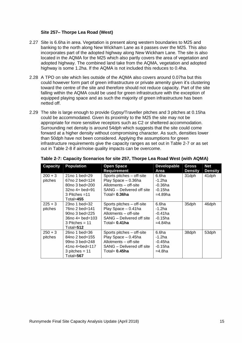
Site 257– Thorpe Lea Road (West)
2.27 Site is 6.6ha in area. Vegetation is present along western boundaries to M25 andbanking to the north along New Wickham Lane as it passes over the M25. This alsoincorporates part of the adopted highway along New Wickham Lane. The site is alsolocated in the AQMA for the M25 which also partly covers the area of vegetation andadopted highway. The combined land take from the AQMA, vegetation and adoptedhighway is some 1.2ha. If the AQMA is not included this reduces to 0.4ha.
2.28 A TPO on site which lies outside of the AQMA also covers around 0.07ha but thiscould however form part of green infrastructure or private amenity given it’s clusteringtoward the centre of the site and therefore should not reduce capacity. Part of the sitefalling within the AQMA could be used for green infrastructure with the exception ofequipped playing space and as such the majority of green infrastructure has beennetted off.
2.29 The site is large enough to provide Gypsy/Traveller pitches and 3 pitches at 0.15hacould be accommodated. Given its proximity to the M25 the site may not beappropriate for more sensitive receptors such as C2 or sheltered accommodation.Surrounding net density is around 54dph which suggests that the site could comeforward at a higher density without compromising character. As such, densities lowerthan 50dph have not been considered. Applying the assumptions for greeninfrastructure requirements give the capacity ranges as set out in Table 2-7 or as setout in Table 2-8 if air/noise quality impacts can be overcome.
Table 2-7: Capacity Scenarios for site 257, Thorpe Lea Road West (with AQMA)
Capacity Population Open SpaceRequirement
DevelopableArea
GrossDensity
NetDensity
200 + 3pitches
21no 1 bed=2967no 2 bed=12480no 3 bed=20032no 4+ bed=913 Pitches =11Total=455
Sports pitches – off-sitePlay Space – 0.36haAllotments – off-siteSANG – Delivered off siteTotal= 0.36ha
6.6ha-1.2ha-0.36ha-0.15ha=4.89ha
31dph 41dph
225 + 3pitches
23no 1 bed=3276no 2 bed=14190no 3 bed=22536no 4+ bed=1033 Pitches = 11Total=512
Sports pitches – off-sitePlay Space – 0.41haAllotments – off-siteSANG – Delivered off siteTotal= 0.41ha
6.6ha-1.2ha-0.41ha-0.15ha=4.84ha
35dph 46dph
250 + 3pitches
26no 1 bed=3684no 2 bed=15599no 3 bed=24841no 4+bed=1173 pitches = 11Total=567
Sports pitches – off-sitePlay Space – 0.45haAllotments – off-siteSANG – Delivered off siteTotal= 0.45ha
6.6ha-1.2ha-0.45ha-0.15ha=4.8ha
38dph 53dph

Runnymede Final Site Capacity Analysis Update (April 2018) 16
Table 2-8: Capacity Scenarios for site 257, Thorpe Lea Road West (withoutAQMA)
Capacity Population Open SpaceRequirement
DevelopableArea
GrossDensity
NetDensity
250 + 3pitches
26no 1 bed=3684no 2 bed=15599no 3 bed=24841no 4+bed=1173 pitches = 11Total=567
Sports pitches – off-sitePlay Space – 0.45haAllotments – off-siteSANG – Delivered off siteTotal= 0.45ha
6.6ha-0.4ha-0.45ha-0.15ha=5.6ha
38dph 45dph
275 + 3pitches
28no 1 bed=3992no 2 bed=170109no 3 bed=27346no 4+bed=1313 pitches = 11Total=624
Sports pitches – off-sitePlay Space – 0.5haAllotments – off-siteSANG – Delivered off siteTotal=
6.6ha-0.4ha-0.5ha-0.15ha=5.55ha
42dph 50dph
2.30 Surrounding net density is around 24-54dph which suggests that the site could comeforward at a higher density without compromising character. As such, capacity isconsidered to be around 250 units and 3 Gypsy/Traveller pitches. If air/noise qualityimpacts can be overcome then this could increase to 275 dwellings and 3Gypsy/Traveller pitches.
Total Capacity
250 (min) C3 Dwellings or if air/noise quality overcome, 275 C3 dwellings.
3 Gypsy/Traveller Pitches

Runnymede Final Site Capacity Analysis Update (April 2018) 17
Plan of Site 257
Runnymede Final Site Capacity Analysis Update (April 2018) 18
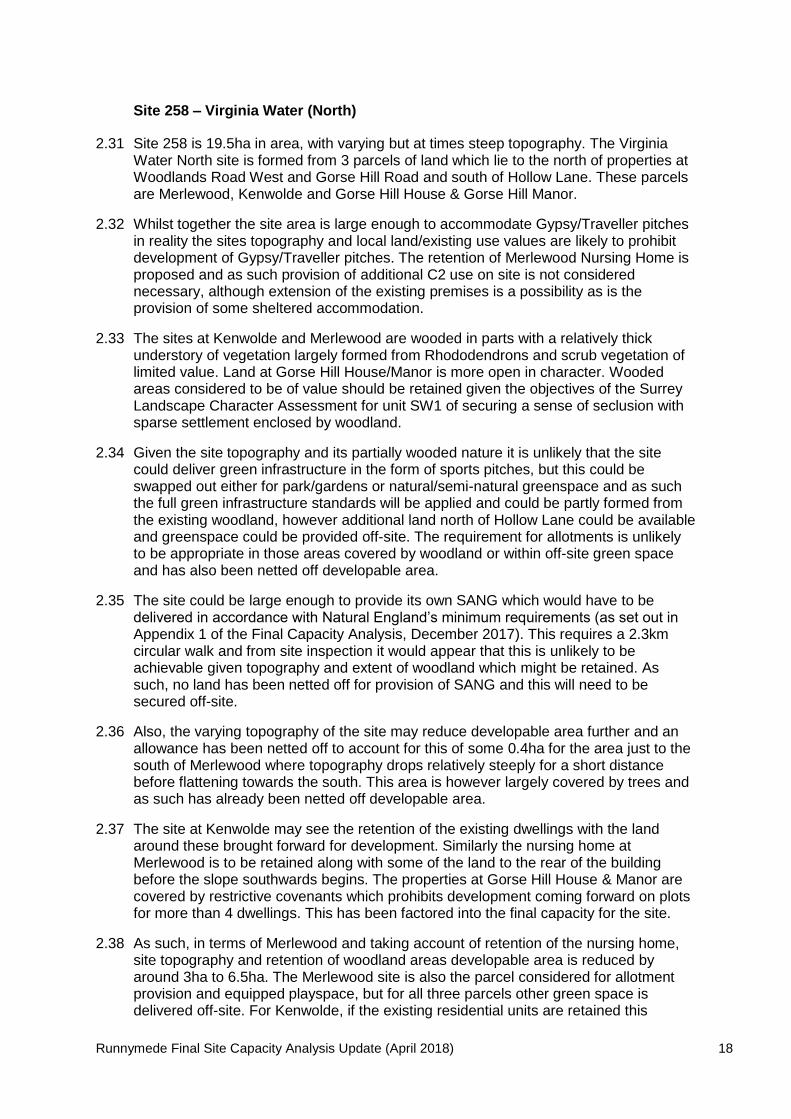
Site 258 – Virginia Water (North)
2.31 Site 258 is 19.5ha in area, with varying but at times steep topography. The VirginiaWater North site is formed from 3 parcels of land which lie to the north of properties atWoodlands Road West and Gorse Hill Road and south of Hollow Lane. These parcelsare Merlewood, Kenwolde and Gorse Hill House & Gorse Hill Manor.
2.32 Whilst together the site area is large enough to accommodate Gypsy/Traveller pitchesin reality the sites topography and local land/existing use values are likely to prohibitdevelopment of Gypsy/Traveller pitches. The retention of Merlewood Nursing Home isproposed and as such provision of additional C2 use on site is not considerednecessary, although extension of the existing premises is a possibility as is theprovision of some sheltered accommodation.
2.33 The sites at Kenwolde and Merlewood are wooded in parts with a relatively thickunderstory of vegetation largely formed from Rhododendrons and scrub vegetation oflimited value. Land at Gorse Hill House/Manor is more open in character. Woodedareas considered to be of value should be retained given the objectives of the SurreyLandscape Character Assessment for unit SW1 of securing a sense of seclusion withsparse settlement enclosed by woodland.
2.34 Given the site topography and its partially wooded nature it is unlikely that the sitecould deliver green infrastructure in the form of sports pitches, but this could beswapped out either for park/gardens or natural/semi-natural greenspace and as suchthe full green infrastructure standards will be applied and could be partly formed fromthe existing woodland, however additional land north of Hollow Lane could be availableand greenspace could be provided off-site. The requirement for allotments is unlikelyto be appropriate in those areas covered by woodland or within off-site green spaceand has also been netted off developable area.
2.35 The site could be large enough to provide its own SANG which would have to bedelivered in accordance with Natural England’s minimum requirements (as set out inAppendix 1 of the Final Capacity Analysis, December 2017). This requires a 2.3kmcircular walk and from site inspection it would appear that this is unlikely to beachievable given topography and extent of woodland which might be retained. Assuch, no land has been netted off for provision of SANG and this will need to besecured off-site.
2.36 Also, the varying topography of the site may reduce developable area further and anallowance has been netted off to account for this of some 0.4ha for the area just to thesouth of Merlewood where topography drops relatively steeply for a short distancebefore flattening towards the south. This area is however largely covered by trees andas such has already been netted off developable area.
2.37 The site at Kenwolde may see the retention of the existing dwellings with the landaround these brought forward for development. Similarly the nursing home atMerlewood is to be retained along with some of the land to the rear of the buildingbefore the slope southwards begins. The properties at Gorse Hill House & Manor arecovered by restrictive covenants which prohibits development coming forward on plotsfor more than 4 dwellings. This has been factored into the final capacity for the site.
2.38 As such, in terms of Merlewood and taking account of retention of the nursing home,site topography and retention of woodland areas developable area is reduced byaround 3ha to 6.5ha. The Merlewood site is also the parcel considered for allotmentprovision and equipped playspace, but for all three parcels other green space isdelivered off-site. For Kenwolde, if the existing residential units are retained this

Runnymede Final Site Capacity Analysis Update (April 2018) 19
reduces developable area by 0.8ha with a further reduction of 0.3ha to account forwooded areas and developable area is either 1.7ha or 2ha. Should the existingdwellings at Kenwolde come forward for development it has been assumed this will beconversion to apartments (circa 15 units). The site at Gorse Hill House and Manorcould only attain a maximum capacity of 8 units (6 net) which could easily beaccommodated within the site area of 5.7ha.
2.39 Surrounding densities are very low ranging between 2-12 net dwellings per hectare.More effective and efficient use of land should be made whilst taking account of thecontext and distinctiveness of the surrounding area and to Landscape Characterobjectives. As such, whilst high density development is unlikely to be appropriate, thisdoes not mean that higher density development than exists in the surrounds could notbe sympathetically designed and accommodated on site, although densitiessignificantly higher than the surrounds have not been considered.
2.40 Given the context and character of the site it is unlikely to be suited towards smallerunits and therefore an assumption has been made that larger units, including 5bedroom units will be provided. However, the site will need to provide some 1 or 2 bedapartments on site given the need for 10% delivery of affordable home ownership asset out in the draft NPPF. Inclusion of apartments will help to lift density of the site.
2.41 As such for the purposes of Merlewood and Kenwolde, an assumption has been madethat 10% of units will be small units split evenly between 1 & 2 beds with an associateduplift in 4 & 5 bed units to 30% and 20% respectively (aside from conversion ofKenwolde to apartments).
2.42 Taking the above into account the developable area and capacity for each parcel ofVirginia Water North is set out in Tables 2-9 to 2-11.
Table 2-9: Capacity for Site 258, Merlewood
Capacity Population Open SpaceRequirement
DevelopableArea
GrossDensity
NetDensity
70 4no 1 bed=63no 2 bed=628no 3 bed=7021no 4 bed=6014no 5+ bed= 50Total=192
Sports pitches – off-sitePlay Space – 0.15haAllotments – 0.035haSANG – Delivered off siteTotal= 0.185ha
9.5ha-3ha-0.185ha-0.062ha=6.25ha
7dph 11dph
85 5no 1 bed=74no 2 bed=734no 3 bed=8526no 4 bed= 7416no 5+ bed= 58Total=231
Sports pitches – off-sitePlay Space – 0.18haAllotments – 0.043haSANG – Delivered off siteTotal= 0.223ha
9.5ha-3ha-0.223ha-0.062ha=6.2ha
9dph 14dph
100 5no 1 bed=75no 2 bed=940no 3 bed=10030no 4 bed=8620no 5+ bed=72Total=274
Sports pitches – off-sitePlay Space – 0.22haAllotments – 0.05haSANG – off-siteTotal= 0.27ha
9.5ha-3ha-0.27ha-0.062ha=6.17ha
11dph 16ph
Runnymede Final Site Capacity Analysis Update (April 2018) 20
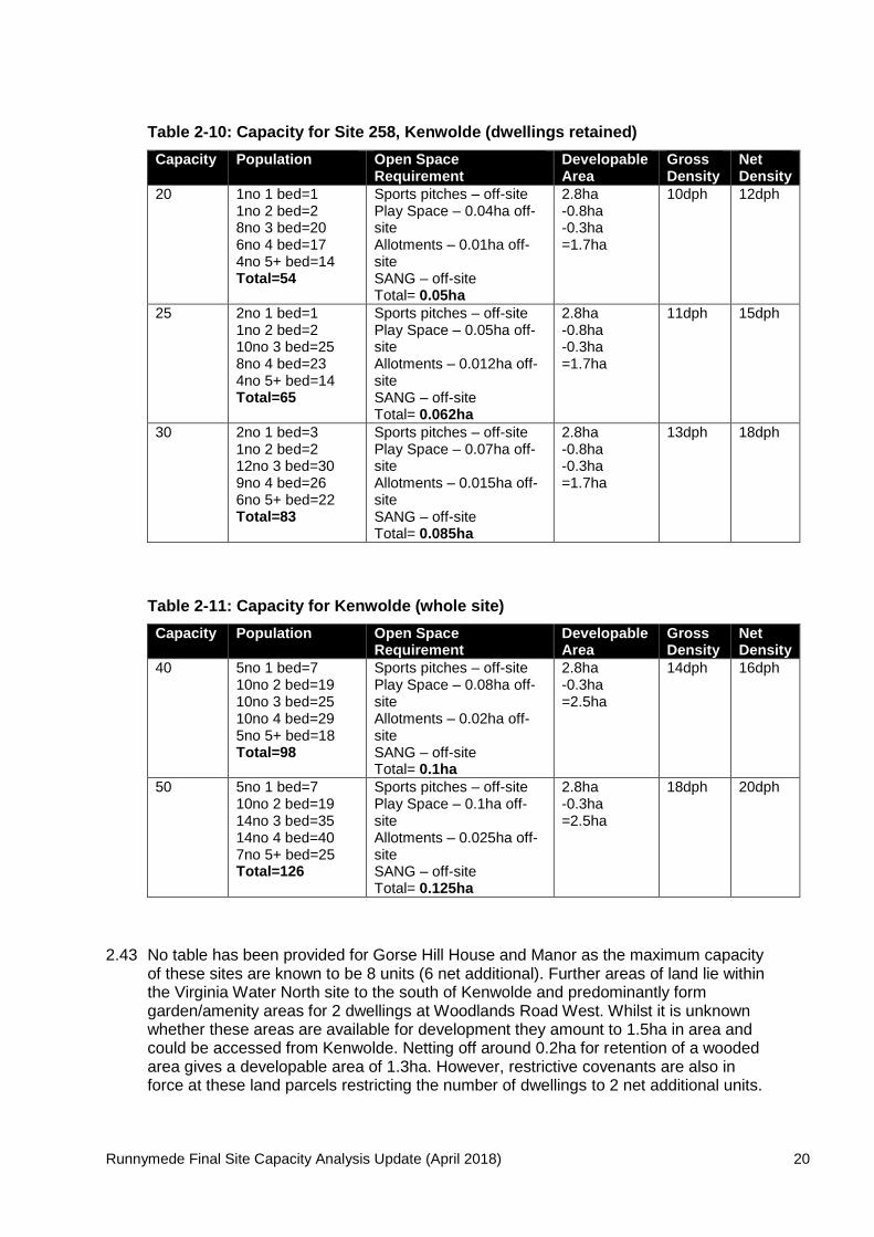
Table 2-10: Capacity for Site 258, Kenwolde (dwellings retained)
Capacity Population Open SpaceRequirement
DevelopableArea
GrossDensity
NetDensity
20 1no 1 bed=11no 2 bed=28no 3 bed=206no 4 bed=174no 5+ bed=14Total=54
Sports pitches – off-sitePlay Space – 0.04ha off-siteAllotments – 0.01ha off-siteSANG – off-siteTotal= 0.05ha
2.8ha-0.8ha-0.3ha=1.7ha
10dph 12dph
25 2no 1 bed=11no 2 bed=210no 3 bed=258no 4 bed=234no 5+ bed=14Total=65
Sports pitches – off-sitePlay Space – 0.05ha off-siteAllotments – 0.012ha off-siteSANG – off-siteTotal= 0.062ha
2.8ha-0.8ha-0.3ha=1.7ha
11dph 15dph
30 2no 1 bed=31no 2 bed=212no 3 bed=309no 4 bed=266no 5+ bed=22Total=83
Sports pitches – off-sitePlay Space – 0.07ha off-siteAllotments – 0.015ha off-siteSANG – off-siteTotal= 0.085ha
2.8ha-0.8ha-0.3ha=1.7ha
13dph 18dph
Table 2-11: Capacity for Kenwolde (whole site)
Capacity Population Open SpaceRequirement
DevelopableArea
GrossDensity
NetDensity
40 5no 1 bed=710no 2 bed=1910no 3 bed=2510no 4 bed=295no 5+ bed=18Total=98
Sports pitches – off-sitePlay Space – 0.08ha off-siteAllotments – 0.02ha off-siteSANG – off-siteTotal= 0.1ha
2.8ha-0.3ha=2.5ha
14dph 16dph
50 5no 1 bed=710no 2 bed=1914no 3 bed=3514no 4 bed=407no 5+ bed=25Total=126
Sports pitches – off-sitePlay Space – 0.1ha off-siteAllotments – 0.025ha off-siteSANG – off-siteTotal= 0.125ha
2.8ha-0.3ha=2.5ha
18dph 20dph
2.43 No table has been provided for Gorse Hill House and Manor as the maximum capacityof these sites are known to be 8 units (6 net additional). Further areas of land lie withinthe Virginia Water North site to the south of Kenwolde and predominantly formgarden/amenity areas for 2 dwellings at Woodlands Road West. Whilst it is unknownwhether these areas are available for development they amount to 1.5ha in area andcould be accessed from Kenwolde. Netting off around 0.2ha for retention of a woodedarea gives a developable area of 1.3ha. However, restrictive covenants are also inforce at these land parcels restricting the number of dwellings to 2 net additional units.

Runnymede Final Site Capacity Analysis Update (April 2018) 21
2.44 Given the surrounding context and character but need to make efficient use of land it isconsidered that minimum capacity at each parcel is: -
Merlewood – 85 dwellings
Kenwolde – 25 or 40 dwellings (dependent on retention of existing dwellings)
Gorse Hill House & Manor – 6 dwellings
Further Areas – 2
2.45 As such total minimum capacity for Virginia Water North is around 120 units.
Total Capacity
120 (min) C3 residential dwellings
Plan of site 258

Runnymede Final Site Capacity Analysis Update (April 2018) 22
Site 261 – Virginia Water (South)
2.46 Site is 5.27ha in area. There is an area of vegetation on the south/west and northboundaries part of which is covered by TPO 420. Boundary vegetation which could beretrained as a buffer to Trumps Green Road, rail line, Wentworth Estate and propertiesat Knowle Hill and the area covered by the TPO account for some 0.8ha (0.2ha and0.6ha respectively). However, part of the TPO area could be sited within privateamenity space and therefore half of this area has been netted off with the other halfassumed to be incorporated into green infrastructure. There are no other constraintson site which would restrict developable area.
2.47 However, comments submitted for the site during Draft Plan consultation highlightedthe possibility of a roundabout entrance into the site which would have land takeimplications estimated at 0.2ha. However, alternative access could be achieved andtherefore the developable area may not need to reflect provision of a new roundabout.
2.48 The site is large enough to accommodate up to 2 Gypsy/Traveller pitches at 0.10ha,however, whether this is viable given likely land values in Virginia Water will need to betested further. Sports pitches are in evidence in the local area at King George VRecreation Ground and as such these have not been included in the site’s greeninfrastructure requirements.
2.49 Surrounding net density is 7 to 24dph. However, the need to make the most efficientuse of land needs to be taken into account and as such net densities lower than 30dphhave not been considered. Applying the assumptions for green infrastructurerequirements give the capacity ranges as set out in Table 2-12.
Table 2-12: Capacity Scenarios for site 261 Virginia Water South
Capacity Population Open SpaceRequirement
DevelopableArea
GrossDensity
NetDensity
140 + 2Pitches
14no 1 bed=2047no 2 bed=8756no 3 bed=14023no 4+ bed=662 pitches = 7Total=313
Sports pitches – off-sitePlay Space – 0.25haAllotments – off-siteSANG – off-siteTotal= 0.25ha
5.27ha-0.10ha-0.5ha-0.2ha=4.47ha
27dph 31dph
150 + 2Pitches
16no 1 bed=2250no 2 bed=9360no 3 bed=15024no 4+ bed=682 pitches = 7Total=340
Sports pitches – off-sitePlay Space – 0.27haAllotments – off-siteSANG – off-siteTotal= 0.27ha
5.27ha-0.10ha-0.5ha-0.2ha=4.47ha
29dph 33dph
160 + 2Pitches
16no 1 bed=2253no 2 bed=9864no 3 bed=16027no 4+ bed=772 pitches = 7Total=364
Sports pitches – off-sitePlay Space – 0.29haAllotments – off-siteSANG – off siteTotal= 0.29ha
5.27ha-0.10ha-0.5ha-0.2ha=4.47ha
31dph 36dph
2.50 Given the need to make the most efficient use of land but also taking account ofcontext and character the capacity for the Virginia Water South site is a minimum of140 dwellings as well as 2 Gypsy/Traveller pitches. Development proposing higherdensities will need to demonstrate high quality design to ensure integration withexisting character as a whole. Additional dwellings could also be brought forwarddepending on the access arrangements into the site.
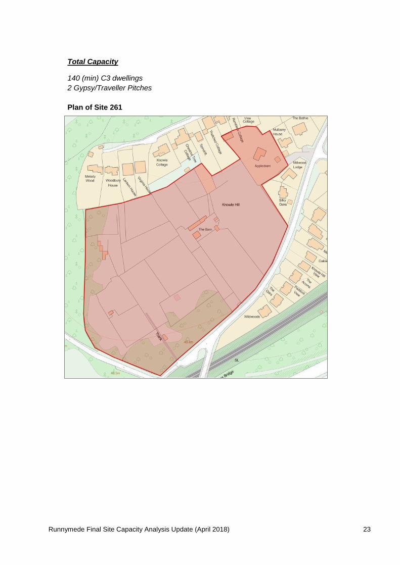
Runnymede Final Site Capacity Analysis Update (April 2018) 23
Total Capacity
140 (min) C3 dwellings
2 Gypsy/Traveller Pitches
Plan of Site 261

Runnymede Final Site Capacity Analysis Update (April 2018) 24
Site 263 – Ottershaw East
2.51 Site is 13.2ha in area. The site is however large enough to provide its own SANG on-site and this coupled with other green infrastructure requirements will reduce thedevelopable area of the site. There is also a fenced/hedged off public footpath whichruns north/south through the site and forms an appropriate boundary for thedevelopable part of the site and which should be retained. As such, developable areawest of the footpath is around 5.9ha and area around The Field Nursery is 0.92hagiving a total area of 6.82ha. However, responses received to the Draft Planconsultation has revealed that three existing residential properties fronting Brox Roadwill not be available for development. This reduces the developable area west of thefootpath by around 0.28ha to 6.54ha.
2.52 The residential curtilage at the Field Nursery is approximately 0.35ha and may not bereleased at the same time as other land at the Field Nursery and the main part ofOttershaw East. If removed from the Green Belt there may be opportunities toredevelop this site in the future and as such this land is retained in the capacityanalysis although for a reduced level of development of around 10 net dwellings. Thedevelopable area for Ottershaw East is therefore around 6.19ha.
2.53 East of the public footpath could be used for SANG and is 7.3ha in area. It is likely that7.3ha of SANG will be an overprovision for the number of dwellings which could beaccommodated west of the footpath. As such, other green infrastructure requirementscould also be located east of the footpath and therefore not netted off the developablearea, however in the interests of designing out crime and surveillance, equippedplaying space should be integrated within the residential development west of thefootpath.
2.54 The site is large enough to provide Gypsy/Traveller accommodation and is capable ofaccommodating 2 Gypsy/Traveller pitches with a land take of 0.10ha.
2.55 An area of vegetation lies on the southern boundary with Southwood Avenue whichcan be retained as a buffer with a land take of around 0.1ha. There is also a drain onsite which requires an 8m buffer distance to any development. The total area of thisbuffer to the west side of the footpath is approximately 0.11ha. The site is also capableof accommodating a new health centre on site with a land take of 0.1ha.
2.56 There are areas of the village that exhibit net densities around the 40dph mark,although the net density in the immediate vicinity of the site is 11 to 26 to dph.Planning application RU.17/1940 at the Brox End Nursery has also recently beenconsidered by the Runnymede Planning Committee with a resolution to grantpermission for 40 dwellings subject to S106. Taking account of the TPO at the BroxEnd site and what is developable, 40 units at Brox End Nursery constitutes a netdensity of around 32dph.
2.57 The draft NPPF advocates that land should be used efficiently and therefore densityshould range higher than the immediate vicinity whilst taking account of surroundingcharacter and the resolution at Brox End Nursery. As such, net densities lower than30dph have not been considered. Applying the assumptions for green infrastructurerequirements give the capacity ranges as set out in Table 2-13.
Runnymede Final Site Capacity Analysis Update (April 2018) 25
Table 2-13: Capacity Scenarios for site 263 Ottershaw East
Capacity Population Open SpaceRequirement
DevelopableArea
GrossDensity
NetDensity
180 + 2pitches
27no 1 bed=3854no 2 bed=10072no 3 bed=18027no 4+ bed=772 Pitches =7Total=402
Sports pitches – 0.64haPlay Space – 0.32haAllotments – 0.09haSANG – 3.44haTotal= 4.49ha
6.19ha-0.21ha-0.1ha-0.1ha-0.32ha=5.46ha
29dph 33dph
190 + 2pitches
29no 1 bed=4157no 2 bed=10576no 3 bed=19028no 4+ bed=802 Pitches =7Total=423
Sports pitches – 0.68haPlay Space – 0.34haAllotments – 0.095haSANG – 3.61haTotal= 4.73ha
6.19ha-0.21ha-0.1ha-0.1ha-0.34ha=5.44ha
31dph 35dph
200 + 2pitches
20no 1 bed=2867no 2 bed=12480no 3 bed=20033no 4+ bed=942 Pitches =7Total=453
Sports pitches – 0.72haPlay Space – 0.36haAllotments – 0.1haSANG – 3.62haTotal= 4.8ha
6.19ha-0.21ha-0.1ha-0.1ha-0.36ha=5.42ha
33dph 37dph
2.58 Given the need to ensure efficient use of land and relatively high accessibility of thesite, but taking account of surrounding context and density at Brox End Nursery, it isconsidered that Ottershaw East could come forward for at least 190 C3 dwellings + 10net additional dwellings at the Field Nursery giving a total of 200 net dwellings and 2Gypsy/Traveller pitches. However, given the higher densities proposed than within theimmediate area, any development will need to ensure high quality design and takeaccount of measures to create/enhance biodiversity features given the need for SANG.
Total Capacity
200 (min) C3 dwellings
2 Gypsy/Traveller Pitches

Runnymede Final Site Capacity Analysis Update (April 2018) 26
Plan of Site 263

Runnymede Final Site Capacity Analysis Update (April 2018)27
3. Site Summaries (all sites)
SiteMin Housing
CapacityGypsy/Traveller
PitchesNursing/CareBed Spaces
ShelteredUnits
Sites with permission
48 – Hanworth Lane,Chertsey (north)
130 0 0 0
17 – Coombelands Lane,Rowtown
40 0 0 0
99 – Longcross GardenVillage
200 0 0 0
Sites w/o permission
14 – Brox Road Nursery 40 0 0 0
34 – Parklands, Parcel D,Chertsey Bittams
125-200 0 93 0
48 – Hanworth Lane,Chertsey (south)
210 0 0 0
60 – Pyrcroft Road,Chertsey
275 5 0 0
97, 99 & 221 LongcrossGarden Village
1,500 10 0 60
156 Blay’s House, Blay’sLane, Englefield Green
100 0 0 0
217 – Land West ofWheeler’s Green, Parcel
E, Chertsey Bittams75-105 0 0 0
231 – St Peter’s Hospital,Chertsey
400 0 70 0
254 - Parcel B, VeterinaryLaboratory Site, Rowtown
(Rowtown West, OldRoad)
150 2 0 0
255 – Chertsey Bittams –Parcel A
175 5 0 0
255 – Chertsey Bittams –Parcel B
120 2 0 0
255 – Chertsey Bittams –Parcel C
35 1 0 0
256 – Thorpe Lea RoadNorth
90 2 0 0
257 – Thorpe Lea RoadWest
250 3 0 0
258 – Virginia WaterNorth
120 0 0 0
261 – Virginia WaterSouth
140 2 0 0
263 – Ottershaw East 200 2 0 0
Total 4,375-4,480 34 163 60
Site Employment Capacity
51 – Byfleet Road 34,500sqm (Class B8)

All enquiries about this paper should be directed to:
Policy & Strategy TeamPlanning Business Centre
Runnymede Borough CouncilThe Civic CentreStation RoadAddlestoneSurrey KT15 2AH
Tel 01932 838383
Further copies of this publication can be obtained from the above address,or email: [email protected]
www.runnymede.gov.uk
2018


