RURAL LIVING DEVELOPMENT GUIDELINES MURRINDINDI SHIRE Prepared by: Regional Planning Services and Ellen Hogan & Associates for Murrindindi Shire Council and Goulburn Broken Catchment Management Authority March 2004 Murrindindi Shire Council
Transcript
RURAL LIVING DEVELOPMENT GUIDELINES
MURRINDINDI SHIRE
Prepared by:
Regional Planning Services and Ellen Hogan & Associates for Murrindindi Shire Council and Goulburn Broken Catchment Management Authority
March 2004
Murrindindi Shire Council
TABLE OF CONTENTS
PAGE
1. Purpose 3
2. Background 3
3. Implementation 4
4. Land Management Plans 4
GUIDELINES:
GUIDELINE 1: BIODIVERSITY 5
GUIDELINE 2: WATER QUALITY 8
GUIDELINE 3: EROSION AND SOIL 9
GUIDELINE 4: PESTS PLANTS AND ANIMALS 11
GUIDELINE 5: RURAL LANDSCAPES AND SIGNIFICANT RIDGELINES 12
GUIDELINE 6: AGRICULTURE AND RURAL LAND CONFLICT 13
GUIDELINE 7: ROADS AND INFRASTRUCTURE 15
GUIDELINE 8: DAMS 16
GUIDELINE 9: ON SITE WASTEWATER MANAGEMENT 18
GUIDELINE 10: SUBDIVISION 19
GUIDELINE 11: DWELLINGS, BUILDINGS AND WORKS 21
APPENDICES:
APPENDIX 1: LAND MANAGEMENT PLAN REQUIREMENTS 23
APPENDIX 2: RURAL LIVING DEVELOPMENT GUIDELINE AND
APPLICANT CHECKLISTS 25
APPENDIX 3 REFERENCE DOCUMENTS 30
APPENDIX 4: MURRINDINDI SHIRE COUNCIL AND OTHER CONTACTS 31
APPENDIX 5: GLOSSARY OF TERMS 33
APPENDIX 6: FRAMEWORK FOR DAMS UNDER NEW LEGISLATION 34
APPENDIX 7: RECOMMENDED NATIVE VEGETATION PLANTING MURRINDINDI SHIRE Refer to the separate document Appendix 7
Rural Living Development Guidelines Murrindindi Shire, March 2004 3
1. Purpose
The Rural Living Development Guidelines Murrindindi Shire, March 2004 have been prepared to assist in the use, subdivision and development of land in the Rural Living Zone of the Murrindindi Shire. They are intended to guide ‘landscape change’, such as subdivision and development proposals, while taking into consideration existing land uses, farmers rights, catchment management principles and net environmental gain.
These guidelines form an integrated approach between landowners, Murrindindi Shire Council, relevant state government departments, relevant agencies and community interest groups.
A list of agencies, departments and groups involved in rural development in the Murrindindi Shire is included in Appendix 4.
2. Background
There is a range of relevant Commonwealth, State and Local Government legislation and policy that is relevant to land use and development in rural living areas, and to the principles of net environmental gain.
A primary guiding framework for rural living areas is the Goulburn Broken Regional Catchment Strategy, November 2003. This strategy outlines the key principle of ‘landscape change’, where net environmental gain is achieved through the use and development for land for ‘rural living’ purposes. The Goulburn Broken Regional Catchment Strategy, November 2003 highlights catchment issues, including:
Dryland salinity
Water Resource Management and flooding (salt, nutrients, turbidity, stream flows, modifications to riparian zones and flooding, flood protection, groundwater)
Pests, plants and animals
Soil threats (acidity, erosion, soil and water contaminants, soil biodiversity, sodicity, structure)
Biodiversity (habitat loss, fragmentation)
The regional strategy lists the following triple bottom line goals that have been adopted by the Goulburn Broken Catchment Management Authority (GBCMA).
Environment Goal
To protect and enhance natural assets and their supporting infrastructure in a way that provides benefits for:
native biodiversity
social and economic aspects
Social Goal
To manage natural assets and their supporting infrastructure in a way that:
is responsive to the visions and values of communities of interest and is what the community wants to achieve socially
recognises the opportunities for management presented by existing and evolving social networks
Economic Goal
To manage natural assets and their supporting infrastructure in a way that:
is responsive to what the community wants and can afford to achieve economically
recognises the opportunities for the further sustainable development of those assets
The Goulburn Broken Regional Catchment Strategy, November 2003 recognises that best management practice will not deliver all catchment outcomes. GBCMA has identified that landscape change will occur over the next five years with an opportunity to achieve integrated catchment outcomes.
Landscape change is an ongoing process. In irrigation areas, intensification of agriculture is resulting in a doubling of production every ten years, while the area of land used for irrigation is declining. The catchment will experience the following shifts in land use patterns over the next fifty years:
Rural Living Development Guidelines Murrindindi Shire, March 2004 4An intensive agricultural zone with a smaller ecological footprint – “double the production from half the land”
An increased “conservation” zone where the land retired from agriculture is managed for its nature conservation and ecosystem services
Rural living areas where land, particularly near urban centres, is converted to small landholdings where the main household income is from activities other than agriculture and which may offer additional conservation benefits
These guidelines directly implement the third component of this new land use pattern that is establishment of rural living areas to provide conservation benefits.
Native vegetation frameworks for Victoria and the Goulburn Broken Catchment are very relevant to the future landscape changes in Murrindindi Shire. The guiding principle for the frameworks is to achieve a net environmental gain. These frameworks outline the need to protect and enhance existing native vegetation, however where this is unavoidable, offsets can be considered.
A comprehensive list of legislative and policy frameworks relevant to the Rural Living Development Guidelines Murrindindi Shire, March 2004 is outlined in Appendix 3.
3. Implementation
These guidelines are listed in the Murrindindi Planning Scheme as a ‘policy’ or ‘reference’ document. The guidelines will assist developers when applying for a planning permit for subdivision, dwellings and intensive agricultural proposals.
These guidelines can also be used in an advisory capacity to assist land uses and developments in the Rural Living Zone that do not require planning approval under the Murrindindi Planning Scheme. The guidelines have suggestions and references to assist landholders in a range of land use decisions such as designing and siting buildings and works, minimising conflicts, selection of suitable native vegetation species and how to ensure the future sustainable use of land.
4. Land Management Plans
These guidelines require a land management plan to be developed for all subdivision and intensive agricultural proposals. A land management plan requires an outline of the proposed subdivision or development, including:
A land analysis showing site features and constraints
The opportunities for rural living development and associated agricultural use
Net environmental gains
Water management
Impacts on adjoining land
Other objectives as outlined in these guidelines
A land management plan will not only guide development on a site-to-site basis but also encourage an integrated approach to the natural and physical features, constraints and opportunities of an area. A more detailed outline of what is required for a land management plan is outlined in Appendix 1.
Rural Living Development Guidelines Murrindindi Shire, March 2004 5
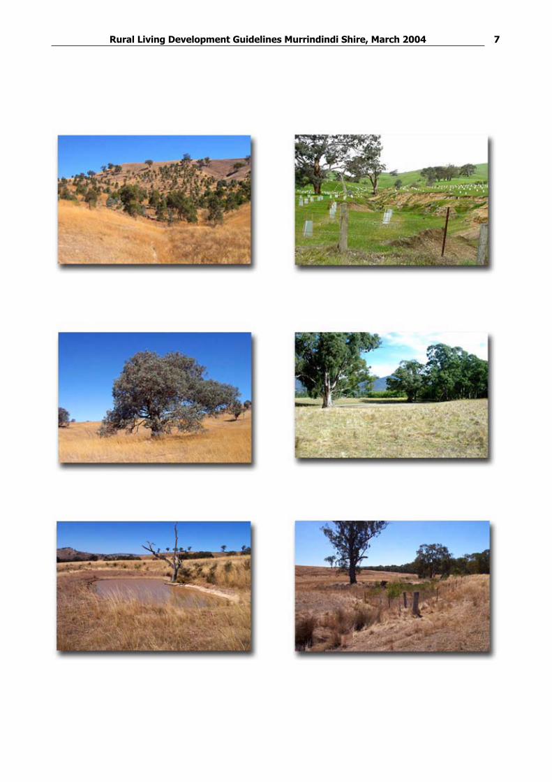
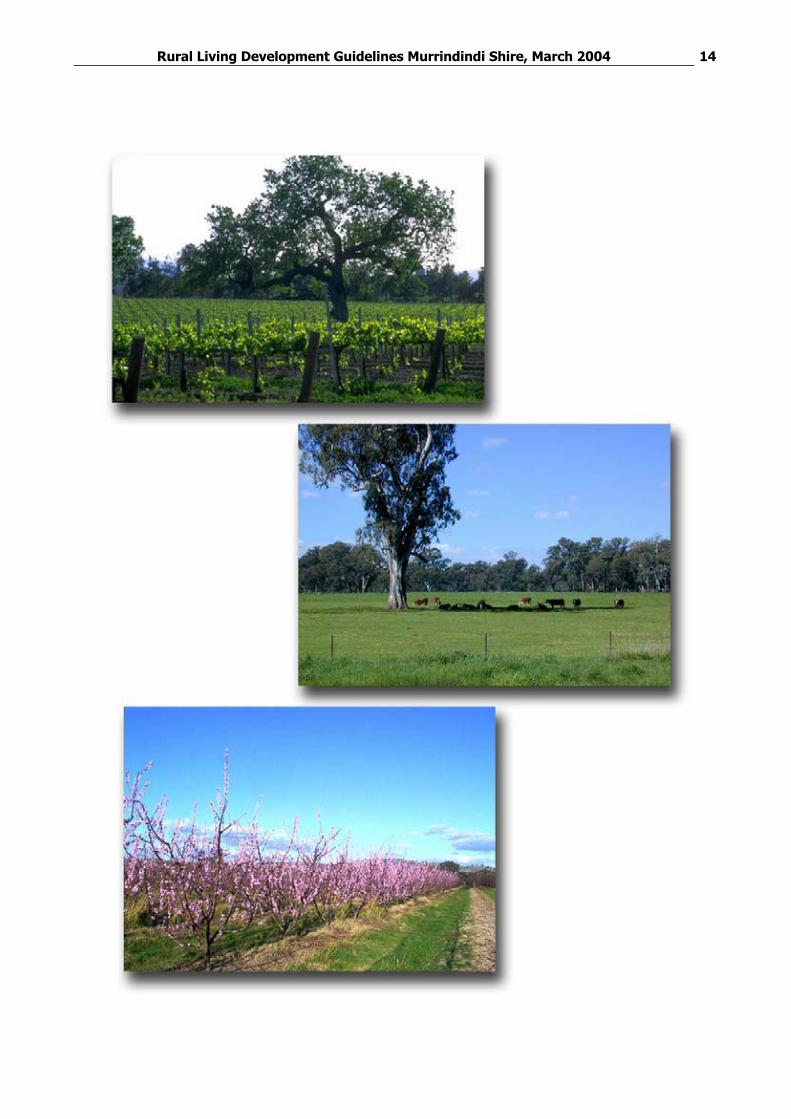
GUIDELINE 1: BIODIVERSITY
The primary goal for the Victorian Government Victoria’s Native Vegetation Management – A framework for action, (the Framework) is ‘A reversal, across the entire landscape, of the long-term decline in the extent and quality of native vegetation, leading to a Net Gain’. Achieving this primary goal will contribute to overall outcomes for biodiversity, sustainable development, land and water quality, and climate change. The NetGain policy applies to both private and public land.
Native vegetation includes native trees, shrubs, ground covers and grasses. Native grasses and ground covers are sometimes mistaken and considered to be non-native, important or worthy of protection. These native grasses and ground covers contribute to the overall health of remnant vegetation and are often of particular conservation significance.
Scattered trees are often the only remaining native vegetation on private land. These trees provide important benefits for vegetation cover, fauna habitat, stock shelter and landscape values. It is important that the removal of these scattered trees is avoided when possible and the likely impacts on tree health are considered in planning the use and development of rural living land. When tree loss is unavoidable, appropriate offsets to achieve net gain must be applied. Offsets are to be assessed and determined in accordance with the Framework.
Roadsides often contain significant areas of native vegetation. Clearing of this vegetation to allow services and access to subdivisions can be a significant loss that needs to be managed by considering the principles in the Framework and the policy of Net Gain.
Protect remnant native vegetation and increase the cover of native vegetation
Maintain and enhance conservation and biodiversity values by reversing the long term decline in the extent and quality of native vegetation
Achieve a ‘Net Gain’ policy in native vegetation in rural living areas
Recognise the use and economic value of native vegetation for agriculture, timber production, rural landscape and land value
Encourage timber production to facilitate conservation and economic objectives of land, particularly through the use of native timber production
Identify, maintain and enhance remnant vegetation areas, including stands of remnant vegetation and individual paddock trees
Identify remnant native vegetation for protection, including use of the report Murrindindi Shire Land Capability Analysis and Environmental Values, 2002
Identify, support and protect threatened species, ecological vegetation classes (EVCs) and depleted broad vegetation types (BVTs)
Apply the 3 step approach to avoid the clearance of vegetation (avoid, minimize, offset). If vegetation clearance cannot be avoided, minimise clearance and apply appropriate offset options in accordance with the Framework in consultation with the Department of Sustainability and Environment and the Department of Primary Industries.
Provide fenced vegetation corridors (bio-corridors) of native vegetation at least 30 metres wide that:
Link native vegetation areas on both private and public area land
Follow waterways and natural drainage lines
Link or widen road reserves
Use the Murrindindi Planning Scheme to protect remnant native vegetation
Each application must include a flora and fauna study that includes:
An inventory of existing remnant vegetation in the form of blocks of native vegetation (trees, shrubs, ground cover and native grasses) or individual scattered trees, either dead or alive. This inventory is to include the species present, area (ha) or DBH (m) of scattered trees, landscape value, landscape hazard and any significant flora and fauna.
When areas of native vegetation exist, an assessment of the quality of vegetation in habitat hectares
Prepare a detailed application that:
Links remnant vegetation on the land and adjoining land
Establishes native vegetation corridors
Rural Living Development Guidelines Murrindindi Shire, March 2004 6
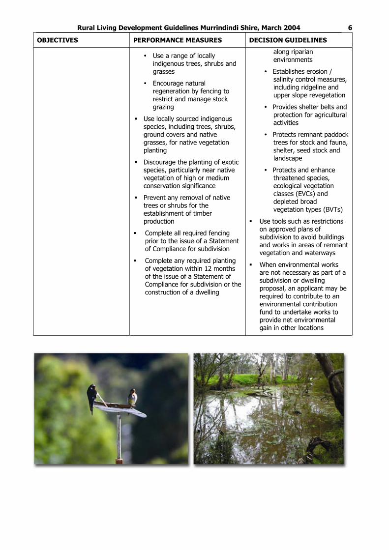
Use a range of locally indigenous trees, shrubs and grasses
Encourage natural regeneration by fencing to restrict and manage stock grazing
Use locally sourced indigenous species, including trees, shrubs, ground covers and native grasses, for native vegetation planting
Discourage the planting of exotic species, particularly near native vegetation of high or medium conservation significance
Prevent any removal of native trees or shrubs for the establishment of timber production
Complete all required fencing prior to the issue of a Statement of Compliance for subdivision
Complete any required planting of vegetation within 12 months of the issue of a Statement of Compliance for subdivision or the construction of a dwelling
along riparian environments
Establishes erosion / salinity control measures, including ridgeline and upper slope revegetation
Provides shelter belts and protection for agricultural activities
Protects remnant paddock trees for stock and fauna, shelter, seed stock and landscape
Protects and enhance threatened species, ecological vegetation classes (EVCs) and depleted broad vegetation types (BVTs)
Use tools such as restrictions on approved plans of subdivision to avoid buildings and works in areas of remnant vegetation and waterways
When environmental works are not necessary as part of a subdivision or dwelling proposal, an applicant may be required to contribute to an environmental contribution fund to undertake works to provide net environmental gain in other locations
Rural Living Development Guidelines Murrindindi Shire, March 2004 7
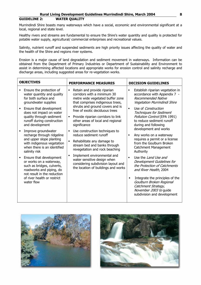
Rural Living Development Guidelines Murrindindi Shire, March 2004 8GUIDELINE 2: WATER QUALITY
Murrindindi Shire boasts many waterways which have a social, economic and environmental significant at a local, regional and state level.
Healthy rivers and streams are fundamental to ensure the Shire’s water quantity and quality is protected for potable water supply, agricultural/ commercial enterprises and recreational values.
Salinity, nutrient runoff and suspended sediments are high priority issues affecting the quality of water and the health of the Shire and regions river systems.
Erosion is a major cause of land degradation and sediment movement in waterways. Information can be obtained from the Department of Primary Industries or Department of Sustainability and Environment to assist in determining affected locations and appropriate works for erosion control and salinity recharge and discharge areas, including suggested areas for re-vegetation works.
Ensure the protection of water quantity and quality for both surface and groundwater supplies
Ensure that development does not impact on water quality through sediment runoff during construction and development
Improve groundwater recharge through ridgeline and upper slope planting with indigenous vegetation when there is an identified salinity risk
Ensure that development or works on a waterway, such as bridges, culverts, roadworks and piping, do not result in the reduction of river health or restrict water flow
Retain and provide riparian corridors with a minimum 30 metre wide vegetated buffer zone that comprises indigenous trees, shrubs and ground covers and is free of exotic deciduous trees
Provide riparian corridors to link other areas of local and regional significance
Use construction techniques to reduce sediment runoff
Rehabilitate any damage to stream bed and banks through revegetation and rock beaching
Implement environmental and water sensitive design when considering subdivision layout and the location of buildings and works
Establish riparian vegetation in accordance with Appendix 7 - Recommended Native Vegetation Murrindindi Shire
Use of Construction Techniques for Sediment Pollution Control (EPA 1991) to reduce sediment runoff during and following development and works
Any works on a waterway requires a permit or a license from the Goulburn Broken Catchment Management Authority
Use the Land Use and Development Guidelines for the Protection of Catchments and River Health, 2004
Integrate the principles of the Goulburn Broken Regional Catchment Strategy, November 2003 to guide subdivision and development
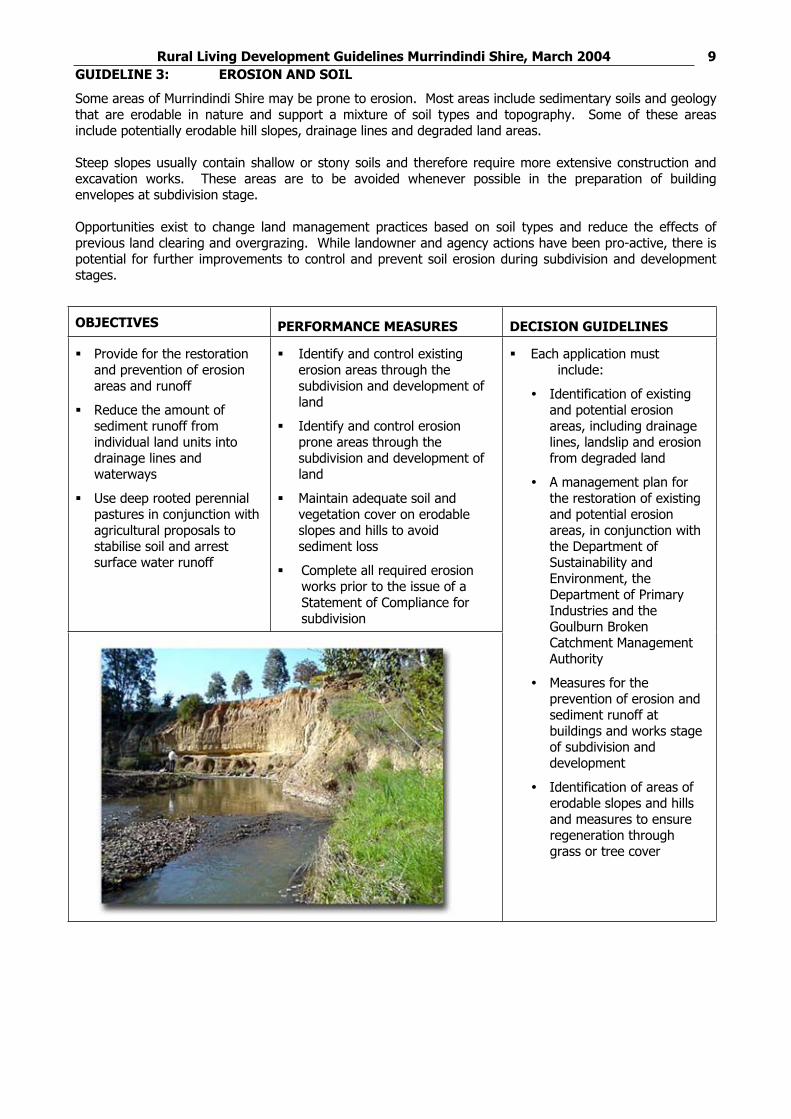
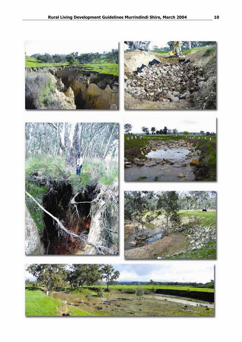
Rural Living Development Guidelines Murrindindi Shire, March 2004 9GUIDELINE 3: EROSION AND SOIL
Some areas of Murrindindi Shire may be prone to erosion. Most areas include sedimentary soils and geology that are erodable in nature and support a mixture of soil types and topography. Some of these areas include potentially erodable hill slopes, drainage lines and degraded land areas.
Steep slopes usually contain shallow or stony soils and therefore require more extensive construction and excavation works. These areas are to be avoided whenever possible in the preparation of building envelopes at subdivision stage.
Opportunities exist to change land management practices based on soil types and reduce the effects of previous land clearing and overgrazing. While landowner and agency actions have been pro-active, there is potential for further improvements to control and prevent soil erosion during subdivision and development stages.
Provide for the restoration and prevention of erosion areas and runoff
Reduce the amount of sediment runoff from individual land units into drainage lines and waterways
Use deep rooted perennial pastures in conjunction with agricultural proposals to stabilise soil and arrest surface water runoff
Identify and control existing erosion areas through the subdivision and development of land
Identify and control erosion prone areas through the subdivision and development of land
Maintain adequate soil and vegetation cover on erodable slopes and hills to avoid sediment loss
Complete all required erosion works prior to the issue of a Statement of Compliance for subdivision
Each application must include:
Identification of existing and potential erosion areas, including drainage lines, landslip and erosion from degraded land
A management plan for the restoration of existing and potential erosion areas, in conjunction with the Department of Sustainability and Environment, the Department of Primary Industries and the Goulburn Broken Catchment Management Authority
Measures for the prevention of erosion and sediment runoff at buildings and works stage of subdivision and development
Identification of areas of erodable slopes and hills and measures to ensure regeneration through grass or tree cover
Rural Living Development Guidelines Murrindindi Shire, March 2004 10
Rural Living Development Guidelines Murrindindi Shire, March 2004 11GUIDELINE 4: PESTS PLANTS AND ANIMALS
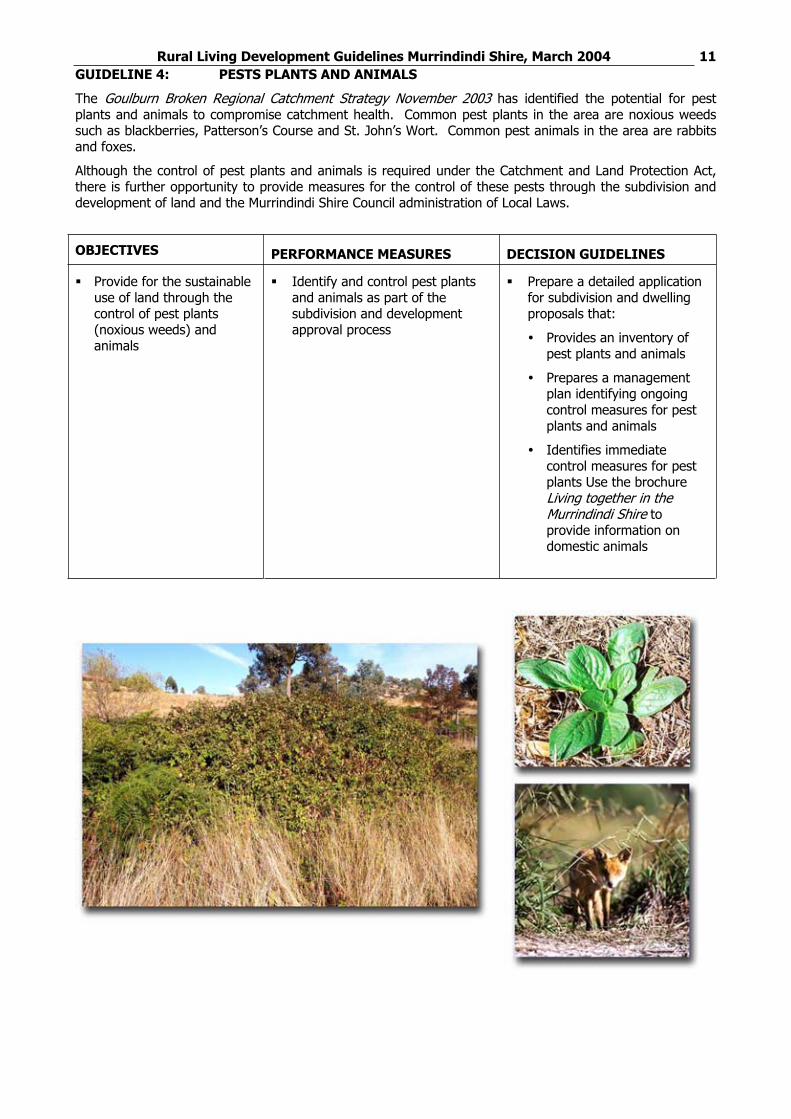
The Goulburn Broken Regional Catchment Strategy November 2003 has identified the potential for pest plants and animals to compromise catchment health. Common pest plants in the area are noxious weeds such as blackberries, Patterson’s Course and St. John’s Wort. Common pest animals in the area are rabbits and foxes.
Although the control of pest plants and animals is required under the Catchment and Land Protection Act, there is further opportunity to provide measures for the control of these pests through the subdivision and development of land and the Murrindindi Shire Council administration of Local Laws.
Provide for the sustainable use of land through the control of pest plants (noxious weeds) and animals
Identify and control pest plants and animals as part of the subdivision and development approval process
Prepare a detailed application for subdivision and dwelling proposals that:
Provides an inventory of pest plants and animals
Prepares a management plan identifying ongoing control measures for pest plants and animals
Identifies immediate control measures for pest plants Use the brochure Living together in the Murrindindi Shire toprovide information on domestic animals
Rural Living Development Guidelines Murrindindi Shire, March 2004 12
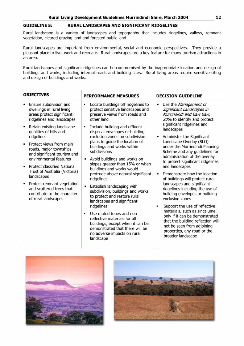
GUIDELINE 5: RURAL LANDSCAPES AND SIGNIFICANT RIDGELINES
Rural landscape is a variety of landscapes and topography that includes ridgelines, valleys, remnant vegetation, cleared grazing land and forested public land.
Rural landscapes are important from environmental, social and economic perspectives. They provide a pleasant place to live, work and recreate. Rural landscapes are a key feature for many tourism attractions in an area.
Rural landscapes and significant ridgelines can be compromised by the inappropriate location and design of buildings and works, including internal roads and building sites. Rural living areas require sensitive siting and design of buildings and works.
Ensure subdivision and dwellings in rural living areas protect significant ridgelines and landscapes
Retain existing landscape qualities of hills and ridgelines
Protect views from main roads, major townships and significant tourism and environmental features
Protect classified National Trust of Australia (Victoria) landscapes
Protect remnant vegetation and scattered trees that contribute to the character of rural landscapes
Locate buildings off ridgelines to protect sensitive landscapes and preserve views from roads and other land
Include building and effluent disposal envelopes or building exclusion zones on subdivision plans to guide the location of buildings and works within subdivisions
Avoid buildings and works on slopes greater than 15% or when buildings and works would protrude above natural significant ridgelines
Establish landscaping with subdivision, buildings and works to protect and restore rural landscapes and significant ridgelines
Use muted tones and non reflective materials for all buildings, except when it can be demonstrated that there will be no adverse impacts on rural landscape
Use the Management of Significant Landscapes in Murrindindi and Baw Baw, 2006 to identify and protect significant ridgelines and landscapes
Administer the Significant Landscape Overlay (SLO) under the Murrindindi Planning Scheme and any guidelines for administration of the overlay to protect significant ridgelines and landscapes
Demonstrate how the location of buildings will protect rural landscapes and significant ridgelines including the use of building envelopes or building exclusion zones
Support the use of reflective materials, such as zincalume, only if it can be demonstrated that the building reflection will not be seen from adjoining properties, any road or the broader landscape
Rural Living Development Guidelines Murrindindi Shire, March 2004 13GUIDELINE 6: AGRICULTURE AND RURAL LAND CONFLICT
Agriculture is the major rural land use in Murrindindi Shire and forms a major activity in the Rural Living Zone. While agriculture will continue to be a major land use in these areas, it is important that it is compatible with residential uses and environmental objectives.
Agriculture today is essentially a ‘rural industry’ that can be very intensive, have irregular hours and cause potential nuisance to nearby rural living activities. Activities such as truck movements on unmade roads, agricultural spraying, the use of scare guns and frost fans, intensive animal industries and the use of machinery during night time hours can cause nuisance to rural residents.
Under the Rural Living Zone, most new proposals for agriculture will require a planning permit, including broad acre animal grazing and horticulture. This requirement does not apply to existing agriculture, which can legally continue without any need for a planning permit and has a ‘right to farm’ in these areas.
The Rural Living Zone is essentially for residential use in a rural area. It is essential that new agriculture is compatible with rural living objectives and supports catchment management principles. The need for compatibility is particularly important between residential uses and intensive forms of agriculture.
Ensure that the potential for residential use in the Rural Living Zone is not compromised
Avoid potential land use conflict and any use or development that may impact on rural living objectives
Ensure the ongoing sustainable use, development and management of land and water
Encourage the development and use of cottage style industries, valuing added agriculture and tourism related activities
Discourage large scale intensive horticultural uses that have the potential to conflict with the residential use of the land and area
Ensure that any intensive agricultural use of land meets conservation and rural living objectives of the area
Ensure that new land use or agricultural proposals are compatible with adjoining and nearby land, and maintain rural living potential
Ensure that new land uses or agricultural proposals maintain the conservation values of the land, adjoining land and nearby land, including soil and water quality, native vegetation and rural landscape
Discourage new large scale intensive agricultural industries that may adversely affect ‘rural residential’ amenity through the use of sprays, scare guns, fans, night time agricultural operations and use of heavy machinery
Use land management plans for any intensive agricultural proposals to:
Outline the scale and nature of the agricultural use and development Assess soil types, land form and agricultural suitability Assess potential impacts on adjoining and nearby land, land uses and developmentsDemonstrate how the proposal will affect the potential use of the land, adjoining land and nearby land for rural living purposesDemonstrate how the proposal will maintain the conservation values of the land, adjoining land and nearby land, including soil and water quality/quantity, native vegetation and rural landscape
Use the brochures Livingtogether in the Murrindindi Shire and Being a Better Rural Neighbour to educate the community about rural living issues and avoid potential land use conflicts in these areas
Consider the use of local laws to regulate activities associated with commercial intensive agriculture that may adversely affect ‘rural residential’ amenity
Rural Living Development Guidelines Murrindindi Shire, March 2004 14
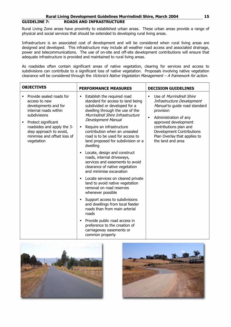
Rural Living Development Guidelines Murrindindi Shire, March 2004 15GUIDELINE 7: ROADS AND INFRASTRUCTURE
Rural Living Zone areas have proximity to established urban areas. These urban areas provide a range of physical and social services that should be extended to developing rural living areas.
Infrastructure is an associated cost of development and will be considered when rural living areas are designed and developed. This infrastructure may include all weather road access and associated drainage, power and telecommunications. The use of on-site and off-site development contributions will ensure that adequate infrastructure is provided and maintained to rural living areas.
As roadsides often contain significant areas of native vegetation, clearing for services and access to subdivisions can contribute to a significant loss of native vegetation. Proposals involving native vegetation clearance will be considered through the Victoria’s Native Vegetation Management – A framework for action.
Provide sealed roads for access to new developments and for internal roads within subdivisions
Protect significant roadsides and apply the 3-step approach to avoid, minimise and offset loss of vegetation
Establish the required road standard for access to land being subdivided or developed for a dwelling through the use of the Murrindindi Shire Infrastructure Development Manual
Require an infrastructure contribution when an unsealed road is to be used for access to land proposed for subdivision or a dwelling
Locate, design and construct roads, internal driveways, services and easements to avoid clearance of native vegetation and minimise excavation
Locate services on cleared private land to avoid native vegetation removal on road reserves whenever possible
Support access to subdivisions and dwellings from local feeder roads than from main arterial roads
Provide public road access in preference to the creation of carriageway easements or common property
Use of Murrindindi Shire Infrastructure Development Manual to guide road standard provision
Administration of any approved development contributions plan and Development Contributions Plan Overlay that applies to the land and area
Rural Living Development Guidelines Murrindindi Shire, March 2004 16
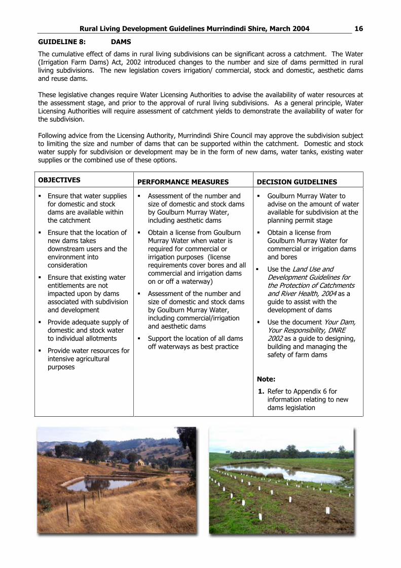
GUIDELINE 8: DAMS
The cumulative effect of dams in rural living subdivisions can be significant across a catchment. The Water (Irrigation Farm Dams) Act, 2002 introduced changes to the number and size of dams permitted in rural living subdivisions. The new legislation covers irrigation/ commercial, stock and domestic, aesthetic dams and reuse dams.
These legislative changes require Water Licensing Authorities to advise the availability of water resources at the assessment stage, and prior to the approval of rural living subdivisions. As a general principle, Water Licensing Authorities will require assessment of catchment yields to demonstrate the availability of water for the subdivision.
Following advice from the Licensing Authority, Murrindindi Shire Council may approve the subdivision subject to limiting the size and number of dams that can be supported within the catchment. Domestic and stock water supply for subdivision or development may be in the form of new dams, water tanks, existing water supplies or the combined use of these options.
Ensure that water supplies for domestic and stock dams are available within the catchment
Ensure that the location of new dams takes downstream users and the environment into consideration
Ensure that existing water entitlements are not impacted upon by dams associated with subdivision and development
Provide adequate supply of domestic and stock water to individual allotments
Provide water resources for intensive agricultural purposes
Assessment of the number and size of domestic and stock dams by Goulburn Murray Water, including aesthetic dams
Obtain a license from Goulburn Murray Water when water is required for commercial or irrigation purposes (license requirements cover bores and all commercial and irrigation dams on or off a waterway)
Assessment of the number and size of domestic and stock dams by Goulburn Murray Water, including commercial/irrigation and aesthetic dams
Support the location of all dams off waterways as best practice
Goulburn Murray Water to advise on the amount of water available for subdivision at the planning permit stage
Obtain a license from Goulburn Murray Water for commercial or irrigation dams and bores
Use the Land Use and Development Guidelines for the Protection of Catchments and River Health, 2004 as a guide to assist with the development of dams
Use the document Your Dam, Your Responsibility, DNRE 2002 as a guide to designing, building and managing the safety of farm dams
Note:
1. Refer to Appendix 6 for information relating to new dams legislation
Rural Living Development Guidelines Murrindindi Shire, March 2004 17
GUIDELINE 9: ON SITE WASTEWATER MANAGEMENT
A major requirement for the use and development of rural living land is to ensure that the water quality of both surface and groundwaters is maintained. When development with small lot sizes is proposed, a land capability assessment will be required to ascertain the capability of the land to accommodate an increased number of on site effluent disposal systems. A land capability assessment is a comprehensive land assessment that is approved by Murrindindi Shire Council Environmental Health Officer.
The Environment Protection Authority has development guidelines for domestic wastewater management, Land Capability Assessment for Onsite Domestic Wastewater Management, Publication 746.1. This document must be used as a guideline at subdivision stage for rural living development.
The approval of individual effluent disposal systems is the role of the Murrindindi Shire Council Environmental Health Officer. Under this role, the Environmental Health Officer issues a Certificate of Installation and a Certificate of Compliance when the system is installed.
Ensure land is capable of containing onsite effluent disposal systems
Ensure the protection of surface and groundwater quality through contaminated wastewater runoff
Prepare a land capability assessment at subdivision stage for all lots in accordance with EPAPublication 746.1, Land Capability Assessment for Onsite Domestic Wastewater Management, March 2003
Refer any proposed land capability assessment to Goulburn Murray Water at subdivision proposal stage
Locate effluent disposal systems within designated building and effluent disposal envelopes
Comply with a management program set out in an approved land capability assessment
Provide individual septic tank permits in accordance with the Septic Tank Code of Practice, Publication 891, March 2003
Land capability assessment and septic tank permits to be assessed and approved by Murrindindi Shire Council’s Environmental Health Officer in accordance with EPAPublication 746.1, Land Capability Assessment for Onsite Domestic Wastewater Management, March 2003 and Septic Tank Code of Practice, Publication 891, March 2003
Rural Living Development Guidelines Murrindindi Shire, March 2004 18
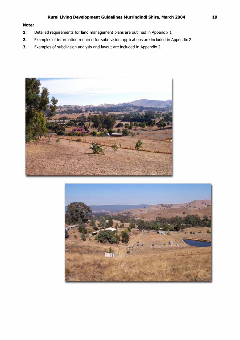
GUIDELINE 10: SUBDIVISION
The objectives of rural living subdivision are to integrate environment, social and economic benefits through the use of these guidelines.
When designing subdivision layouts, the physical features of land will be considered through the use of land management plans. A land management plan will outline the subdivision based on a detailed site assessment. Site assessment and subdivision design will indicate the existing physical features of the land, net environmental gains to be achieved and any opportunities for agricultural production that are compatible with rural living and subdivision and development.
Ensure that the land is capable of supporting subdivision and development
Support subdivision that promotes sustainable land management practices
Provide for rural living opportunities that support net environmental gain and the sustainable agricultural use of the land
Ensure that subdivision has an adequate level of infrastructure
Design subdivision proposals to take into consideration the standards outlined in these guidelines
Support subdivision proposals through the development and approval of a land management plan
Prepare a land capability assessment for all subdivision in accordance with EPA Publication 746.1, Land Capability Assessment for Onsite Domestic Wastewater Management, March 2003
Provide an adequate water supply in the form of tanks, dams or bores to the satisfaction of the Murrindindi Shire Council, in consultation with Goulburn Murray Water
Nominate building and effluent disposal envelopes or building exclusion zones to guide the siting of future dwellings and effluent disposal on proposed lots (ensuring that land capability assessment soil tests match the nominated location of dwellings)
Discourage lots that are ‘battle axe’ in design
Vary allotment sizes to suit site constraints
Complete all required fencing or other works prior to the issue of a Statement of Compliance for subdivision
Complete any required planting of vegetation within 12 months of issue of a Statement of Compliance for subdivision
Any subdivision proposal is to be assessed and justified through the use of a land management plan that includes:
A description of existing site features and land constraints
Subdivision design that considers future land uses and developments based on identified site features and constraints
A land capability assessment in accordance with EPA Publication 746.1,Land Capability Assessment for Onsite Domestic Wastewater Management, March 2003 to meet Murrindindi Shire Council standards, in consultation with Goulburn Murray Water
Availability of a stock and domestic water supply, to the satisfaction of Murrindindi Shire Council and Goulburn Murray Water
Use of the principles of Urban Stormwater: Best Practice Environmental Management Guidelines1999 in design layout
When environmental works are not necessary as part of a subdivision proposal, an applicant may be required to contribute to an environmental contribution fund to undertake works to provide net environmental gain in other locations
Rural Living Development Guidelines Murrindindi Shire, March 2004 19
Note:
1. Detailed requirements for land management plans are outlined in Appendix 1
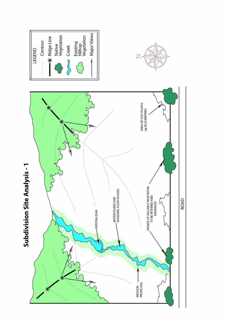
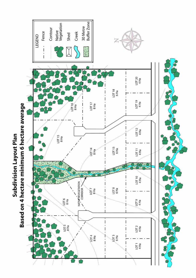
2. Examples of information required for subdivision applications are included in Appendix 2
3. Examples of subdivision analysis and layout are included in Appendix 2
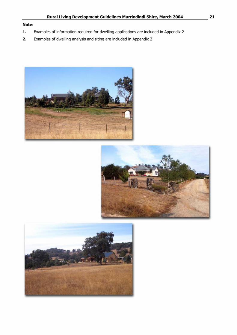
Rural Living Development Guidelines Murrindindi Shire, March 2004 20GUIDELINE 11: DWELLINGS, BUILDINGS AND WORKS
When dwellings in the Rural Living Zone require a planning permit, proposal must integrate environment, social and economic benefits through the use of these guidelines.
Dwelling proposals are to identify and incorporate existing physical features of the land, net environmental gains, ands design and location that are compatible with rural living and subdivision and development.
Ensure that the siting of dwellings does not impact on the surrounding rural landscapes
Ensure that the siting of dwellings, buildings and works do not impact on soil stability, water quality or native vegetation
Design and siting of dwellings to incorporate adequate fire protection measures
Provide for rural living opportunities that support net environmental gain and the sustainable agricultural use of the land
Design dwelling proposals to take into consideration the standards outlined in these guidelines
Prepare a land capability assessment for all dwelling proposals in accordance with EPApublication 746.1, Land Capability Assessment for Onsite Domestic Wastewater Management, March 2003 unless the land capability assessment has been designed and approved in accordance with a subdivision approval under these guidelines
Provide an adequate water supply in the form of tanks, dams or bores to the satisfaction of the Murrindindi Shire Council, in consultation with Goulburn Murray Water
Base the construction and size of dams on catchment yield approved by Murrindindi Shire, in conjunction with Goulburn Murray Water
Complete all required fencing or other works prior to the use of the dwelling if not provided at subdivision stage
Complete any required planting of vegetation within 12 months of the construction of the dwelling
Provide all dwellings with a minimum combined water supply of 55,000 litres, 45,000 of which are to be available for domestic potable water supply, with 10,000 litres being retained exclusively for fire fighting purposes
Any dwelling proposal is to be assessed through the use of a detailed application that includes:
A description of existing site features and land constraints
Dwelling and works siting that considers future land uses and developments based on identified site features and constraints
Compliance with the SepticTank Code of Practice, Publication 891, March 2003 and the EPA publication 746.1, Land Capability Assessment for Onsite Domestic Wastewater Management, March 2003
Availability of a stock and domestic water supply, to the satisfaction of Murrindindi Shire Council and Goulburn Murray Water
Use the principles of Urban Stormwater: Best Practice Environmental Management Guidelines 1999 in design layout
When environmental works are not necessary as part of a dwelling proposal, an applicant may be required to contribute to an environmental contribution fund to undertake works to provide net environmental gain in other locations
Rural Living Development Guidelines Murrindindi Shire, March 2004 21
Note:
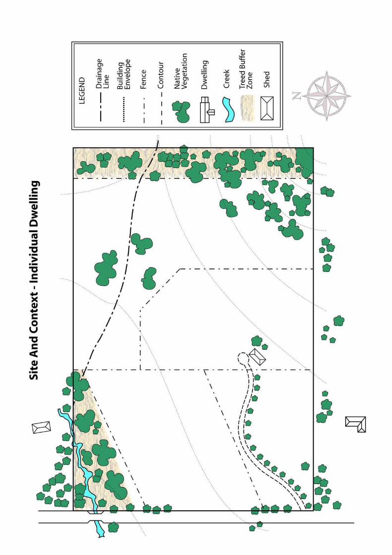
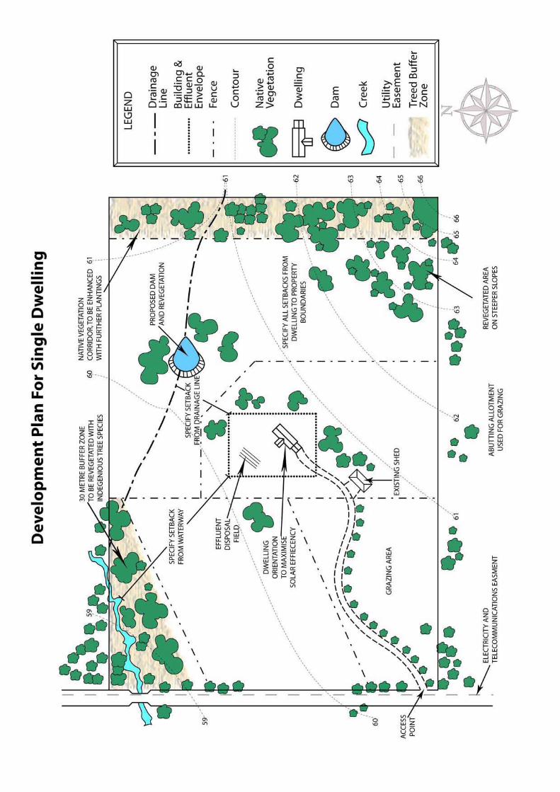
1. Examples of information required for dwelling applications are included in Appendix 2
2. Examples of dwelling analysis and siting are included in Appendix 2
Rural Living Development Guidelines Murrindindi Shire, March 2004 22
APPENDIX 1: LAND MANAGEMENT PLAN REQUIREMENTS
A land management plan is required for subdivision and intensive agricultural proposals.
Applications for subdivision and intensive agricultural development must include a land management plan that shows:
1. Land analysis that includes:
Topography (landscape, geography)
Soil capability
Ridgelines
Slope suitability - steep slopes usually contain shallow or stony soils and therefore require more
extensive construction and excavation works to prevent erosion
Drainage lines, watercourses, wetlands, flood prone and saline areas
Existing dam location, capacities and spillway directions
Native vegetation, including established areas of vegetation and remnant vegetation, either dead or
alive
Weather conditions including prevailing wind patterns, frost potential and overshadowing from hills
Visual factors including important view lines both off and on-site
Active and prone erosion areas
Presence of pest plants
Internal and external road access
Available infrastructure, including power, water and telecommunications
Existing buildings and works
The land analysis can comprise a combination of plans, maps, reports and other visual material.
2. Identification of future land use and development potential that includes:
A description of the possible future uses and developments for rural living, net environmental gain
and agricultural production, including farm forestry
An assessment of the potential impacts of the proposal on adjoining and nearby land
An assessment of how the proposal will maintain the conservation values of the land, adjoining land
and nearby land, including soil and water quality, native vegetation and rural landscape
3. Subdivision, building and development assessment, layout and details that considers and includes:
A subdivision analysis and layout land analysis that includes current and future land use and
development
How the proposed subdivision, building or development meets objectives, performance measures
and decision guidelines outlined in these guidelines
Future works and services, including external and internal road access, electricity and
telecommunications
Building and effluent disposal envelopes or details of all proposed buildings and works that provide
setbacks from and protect adjoining land, waterways, ridgelines, native vegetation and other
significant natural features.
Rural Living Development Guidelines Murrindindi Shire, March 2004 23
Water supply for potable water, fire fighting purposes and stock and domestic use for future
potential uses identified in the land management plan. Water supply can be supplied from dams,
groundwater supplies, and structures such as tanks associated with buildings. If insufficient water is
available for individual allotments, subdivision layout must take into consideration existing dams and
if necessary, design subdivision layout for dam sharing between allotments.
Natural resource issues and opportunities to achieve net environmental gain, including measures for
erosion control, waterway protection, and biodiversity, including protection and revegetation of
native flora
Consideration of solar orientation and efficiency
Protection of significant ridgelines and rural landscapes, including appropriate siting and scale of
buildings and works, and non-reflective buildings materials
Fencing, including fencing to achieve net environmental gain and rural living amenity
Fire prevention measures
Flooding issues, including any approved local floodplain development plan
Ongoing rural living and agricultural land use and management issues outlined in these guidelines,
including opportunities for improved land management practices
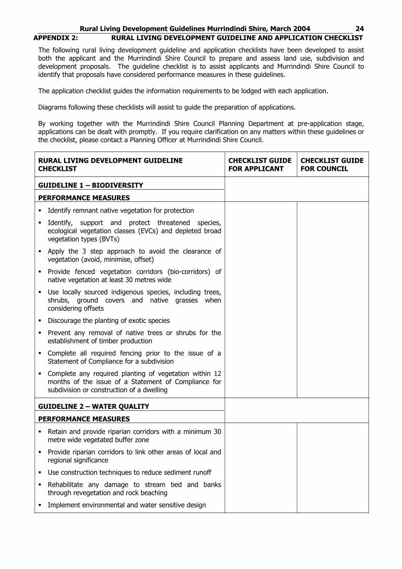
Rural Living Development Guidelines Murrindindi Shire, March 2004 24APPENDIX 2: RURAL LIVING DEVELOPMENT GUIDELINE AND APPLICATION CHECKLIST
The following rural living development guideline and application checklists have been developed to assist both the applicant and the Murrindindi Shire Council to prepare and assess land use, subdivision and development proposals. The guideline checklist is to assist applicants and Murrindindi Shire Council to identify that proposals have considered performance measures in these guidelines.
The application checklist guides the information requirements to be lodged with each application.
Diagrams following these checklists will assist to guide the preparation of applications.
By working together with the Murrindindi Shire Council Planning Department at pre-application stage, applications can be dealt with promptly. If you require clarification on any matters within these guidelines or the checklist, please contact a Planning Officer at Murrindindi Shire Council.
RURAL LIVING DEVELOPMENT GUIDELINE CHECKLIST
CHECKLIST GUIDE FOR APPLICANT
CHECKLIST GUIDE FOR COUNCIL
GUIDELINE 1 – BIODIVERSITY
PERFORMANCE MEASURES
Identify remnant native vegetation for protection
Identify, support and protect threatened species, ecological vegetation classes (EVCs) and depleted broad vegetation types (BVTs)
Apply the 3 step approach to avoid the clearance of vegetation (avoid, minimise, offset)
Provide fenced vegetation corridors (bio-corridors) of native vegetation at least 30 metres wide
Use locally sourced indigenous species, including trees, shrubs, ground covers and native grasses when considering offsets
Discourage the planting of exotic species
Prevent any removal of native trees or shrubs for the establishment of timber production
Complete all required fencing prior to the issue of a Statement of Compliance for a subdivision
Complete any required planting of vegetation within 12 months of the issue of a Statement of Compliance for subdivision or construction of a dwelling
GUIDELINE 2 – WATER QUALITY
PERFORMANCE MEASURES
Retain and provide riparian corridors with a minimum 30 metre wide vegetated buffer zone
Provide riparian corridors to link other areas of local and regional significance
Use construction techniques to reduce sediment runoff
Rehabilitate any damage to stream bed and banks through revegetation and rock beaching
Implement environmental and water sensitive design
Rural Living Development Guidelines Murrindindi Shire, March 2004 25
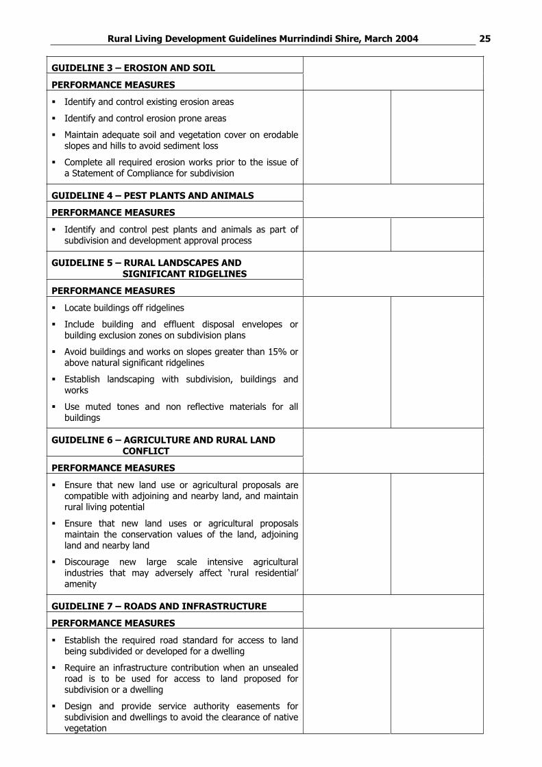
GUIDELINE 3 – EROSION AND SOIL
PERFORMANCE MEASURES
Identify and control existing erosion areas
Identify and control erosion prone areas
Maintain adequate soil and vegetation cover on erodable slopes and hills to avoid sediment loss
Complete all required erosion works prior to the issue of a Statement of Compliance for subdivision
GUIDELINE 4 – PEST PLANTS AND ANIMALS
PERFORMANCE MEASURES
Identify and control pest plants and animals as part of subdivision and development approval process
GUIDELINE 5 – RURAL LANDSCAPES AND SIGNIFICANT RIDGELINES
PERFORMANCE MEASURES
Locate buildings off ridgelines
Include building and effluent disposal envelopes or building exclusion zones on subdivision plans
Avoid buildings and works on slopes greater than 15% or above natural significant ridgelines
Establish landscaping with subdivision, buildings and works
Use muted tones and non reflective materials for all buildings
GUIDELINE 6 – AGRICULTURE AND RURAL LAND CONFLICT
PERFORMANCE MEASURES
Ensure that new land use or agricultural proposals are compatible with adjoining and nearby land, and maintain rural living potential
Ensure that new land uses or agricultural proposals maintain the conservation values of the land, adjoining land and nearby land
Discourage new large scale intensive agricultural industries that may adversely affect ‘rural residential’ amenity
GUIDELINE 7 – ROADS AND INFRASTRUCTURE
PERFORMANCE MEASURES
Establish the required road standard for access to land being subdivided or developed for a dwelling
Require an infrastructure contribution when an unsealed road is to be used for access to land proposed for subdivision or a dwelling
Design and provide service authority easements for subdivision and dwellings to avoid the clearance of native vegetation
Rural Living Development Guidelines Murrindindi Shire, March 2004 26
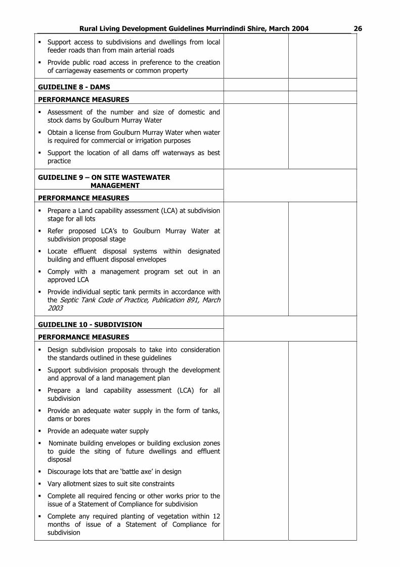
Support access to subdivisions and dwellings from local feeder roads than from main arterial roads
Provide public road access in preference to the creation of carriageway easements or common property
GUIDELINE 8 - DAMS
PERFORMANCE MEASURES
Assessment of the number and size of domestic and stock dams by Goulburn Murray Water
Obtain a license from Goulburn Murray Water when water is required for commercial or irrigation purposes
Support the location of all dams off waterways as best practice
GUIDELINE 9 – ON SITE WASTEWATER MANAGEMENT
PERFORMANCE MEASURES
Prepare a Land capability assessment (LCA) at subdivision stage for all lots
Refer proposed LCA’s to Goulburn Murray Water at subdivision proposal stage
Locate effluent disposal systems within designated building and effluent disposal envelopes
Comply with a management program set out in an approved LCA
Provide individual septic tank permits in accordance with the Septic Tank Code of Practice, Publication 891, March 2003
GUIDELINE 10 - SUBDIVISION
PERFORMANCE MEASURES
Design subdivision proposals to take into consideration the standards outlined in these guidelines
Support subdivision proposals through the development and approval of a land management plan
Prepare a land capability assessment (LCA) for all subdivision
Provide an adequate water supply in the form of tanks, dams or bores
Provide an adequate water supply
Nominate building envelopes or building exclusion zones to guide the siting of future dwellings and effluent disposal
Discourage lots that are ‘battle axe’ in design
Vary allotment sizes to suit site constraints
Complete all required fencing or other works prior to the issue of a Statement of Compliance for subdivision
Complete any required planting of vegetation within 12 months of issue of a Statement of Compliance for subdivision
Rural Living Development Guidelines Murrindindi Shire, March 2004 27
GUIDELINE 11 – DWELLINGS, BUILDINGS AND WORKS
PERFORMANCE MEASURES
Design dwelling proposals to take into consideration the standards outlined in these guidelines
Prepare a land capability assessment (LCA) for all dwelling proposals
Provide an adequate water supply
Base the construction and size of dams on catchment yield
Complete all required fencing or other works prior to the use of the dwelling if not provided at subdivision stage
Complete any required planting of vegetation within 12 months of the construction of the dwelling
Provide all dwellings with a minimum combined water supply of 55,000 litres
Rural Living Development Guidelines Murrindindi Shire, March 2004 28
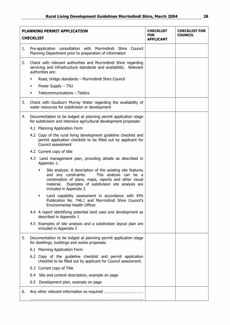
PLANNING PERMIT APPLICATION
CHECKLIST
CHECKLISTFORAPPLICANT
CHECKLIST FOR COUNCIL
1. Pre-application consultation with Murrindindi Shire Council Planning Department prior to preparation of information
2. Check with relevant authorities and Murrindindi Shire regarding servicing and infrastructure standards and availability. Relevant authorities are:
Road, bridge standards – Murrindindi Shire Council
Power Supply – TXU
Telecommunications – Telstra
3. Check with Goulburn Murray Water regarding the availability of water resources for subdivision or development
4. Documentation to be lodged at planning permit application stage for subdivision and intensive agricultural development proposals:
4.1 Planning Application Form
4.2 Copy of the rural living development guideline checklist and permit application checklist to be filled out by applicant for Council assessment
4.2 Current copy of title
4.3 Land management plan, providing details as described in Appendix 1:
Site analysis: A description of the existing site features and any constraints. This analysis can be a combination of plans, maps, reports and other visual material. Examples of subdivision site analysis are included in Appendix 2.
Land capability assessment in accordance with EPA Publication No. 746.1 and Murrindindi Shire Council’s Environmental Health Officer
4.4 A report identifying potential land uses and development as described in Appendix 1
4.5 Examples of site analysis and a subdivision layout plan are included in Appendix 2
5. Documentation to be lodged at planning permit application stage for dwellings, buildings and works proposals:
6.1 Planning Application Form
6.2 Copy of the guideline checklist and permit application checklist to be filled out by applicant for Council assessment
6.3 Current copy of Title
6.4 Site and context description, example on page
6.5 Development plan, example on page
6. Any other relevant information as required ……………………………….
……………………………………………………………………………………………..
Rural Living Development Guidelines Murrindindi Shire, March 2004 29APPENDIX 3 REFERENCE DOCUMENTS:
Reference documents relevant to the Rural Living Development Guidelines are:
Planning
Planning and Environment Act 1987
Murrindindi Planning Scheme
Integrating Local Land Use Planning and Regional Catchment Planning, March 2003
Biodiversity
Environment Protection and Biodiversity Conservation Act 1999
Flora and Fauna Guarantee Act 1988
Victorian Native Vegetation Management – A Framework for Action, Government of Victoria, 2002
Victoria’s Biodiversity Strategy, Government of Victoria, 1997
Revegetation Guide for the Goulburn Broken Catchment, Department of Natural Resources and Environment, July 2001
Goulburn Broken Native Vegetation Plan: Volume 1, Goulburn Broken Native Vegetation Strategy, August 2000 and Volume 2, Draft Native Vegetation Retention Controls – Regional Guidelines for the Goulburn Broken Catchment, draft August 2000
Catchment/ water
Goulburn Broken Regional Catchment Strategy, November 2003 (and sub strategies under this strategy, such as the Upper Goulburn Catchment Recreational Waterway Strategy November 2001, Goulburn Broken Dryland Salinity Management Plan, Goulburn Broken Water Quality Strategy 1996, and GoulburnBroken Weeds Action Plan 2000)
Land Use and Development Guidelines for the Protection of Catchments and River Health 2004
A link between participation, capable communities and environmental gain. A discussion paper prepared for the Goulburn Broken Catchment Management Authority, August 2002.
Landscape change in the Goulburn Broken Catchment, Final report, November 2002
King Parrot Creek and Yea River Streamflow Management Plans
Victorian and Goulburn Broken River Health Strategies
Urban Stormwater: Best Practice Environmental Management Guidelines 1999
Construction Techniques for Sediment Pollution Control, Environment Protection Authority, 1991
Your Dam, Your Responsibility, DNRE 2002
Murrindindi Shire Council policy documents and guidelines
Rural Residential Study Murrindindi Shire, March 2004
Murrindindi Shire Capability Analysis and Environmental Values, August 2002
Kinglake Flowerdale Integrated Strategy Plan, March 2003
Management of Significant Landscapes in Murrindindi and Baw Baw, 2006
Living together in the Murrindindi Shire
Being a Better Rural Neighbour
Effluent Disposal
EPA Publication 746.1, Land Capability Assessment for Onsite Domestic Wastewater Management, March 2003
Septic Tank Code of Practice, Publication 891, March 2003
Rural Living Development Guidelines Murrindindi Shire, March 2004 30APPENDIX 4 MURRINDINDI SHIRE COUNCIL AND OTHER CONTACTS
Shepparton office P O Box 1752 SHEPPARTON VIC 3630
Phone: 03 5820 1100
RURAL WATER AUTHORITIES
Goulburn-Murray Water Southern Rural Water PO Box 153 MAFFRA VIC 3860
Phone: 03 5139 3100
PO Box 165 TATURA VIC 3616
Phone: 03 5833 5500
Rural Living Development Guidelines Murrindindi Shire, March 2004 31
GOULBURN VALLEY WATER
PO Box 185 SHEPPARTON VIC 3632
Phone: 03 5732 0400
DEPARTMENT OF SUSTAINABILITY AND ENVIRONMENT AND DEPARTMENT OF PRIMARY INDUSTRIES
Alexandra Office 46 Aitken Street ALEXANDRA VIC 3714
Phone: 03 5772 0200
Seymour Office 28 High Street,SEYMOUR VIC 3660
Broadford office, 37 High Street BROADFORD VIC 3658
Phone: 03 5784 0600
Phone: 03 5735 4300
ENVIRONMENT PROTECTION AUTHORITY
PO Box 1007 WANGARATTA VIC 3676
Phone: 03 5721 7277
COUNTRY FIRE AUTHORITY
Goulburn Murray Area Region 12 Headquarters Country Fire Authority 52 Tallarook Street SEYMOUR VIC 3661
Phone: 03 5799 1517
VICROADS
PO Box 135 BENALLA VIC 3672
Phone: 03 5761 1888
POWER AND TELECOMMUNICATIONS PROVIDERS
Power and telecommunication carriers can vary between areas. Contact Murrindindi Development Services Department to obtain contact details for power and telecommunications.
LANDCARE GROUPS
There are various Landcare groups that operate in Murrindindi Shire. Contact a Goulburn Broken Catchment Management Authority office for details of local Landcare groups and contacts.
Rural Living Development Guidelines Murrindindi Shire, March 2004 32APPENDIX 5: GLOSSARY OF TERMS
Rural Living Zone: The purposes of the Rural Living Zone in the Murrindindi Planning and Victorian Planning Provisions are:
To implement the State Planning Policy Framework and Local Planning Policy Framework, including the Municipal Strategic Statement and local planning policies.
To provide for residential use in a rural environment.
To provide for agricultural land uses which do not adversely affect the amenity of surrounding land uses.
To protect and enhance the natural resources, biodiversity and landscape and heritage values of the area.
To encourage use and development of land based on comprehensive and sustainable land management practices and infrastructure provision.
Biodiversity: The variety of all life-forms, the different plants, animals and micro-organisms, the genes they contain, and the ecosystems of which they form a part.
Net Environmental Gain: is where, over a specified area and period time, losses of native vegetation and habitat, as measured by a combined quality-quantity measure (habitat hectare), are reduced, minimised and more than offset by commensurate gains.
Land Management Plan: A management tool that considers the total assets of the farm – soil, water, trees, stock, pastures, crops and wildlife – and how to make the best use of them on your particular property.
Rural Living Development Guidelines Murrindindi Shire, March 2004 33APPENDIX 6: FRAMEWORK FOR DAMS UNDER NEW LEGISLATION
Following the introduction of the Water (Irrigation Farm Dams) Act, new legislative mechanisms control dams on multi-lot subdivisions. Under the provisions of Section 32A (3)(n) of the Act, a management plan may prescribe the maximum volume of water that may be retained for a relevant water supply protection area or any part of it:
In each private dam on a particular lot in a subdivision; or
In all private dams on every lot in the subdivision
This provision relates to dams both on and off waterways.
Prior to the approval of a new subdivision, the future water needs of the subdivision need to be assessed. Murrindindi Shire Council is required to refer planning permit applications for subdivision to the relevant water authority under referral requirements found in Clause 66 of all planning schemes.
Licensing Authorities comments on the proposed subdivision should include reference to the potential impact of dams within the subdivision based on sustainable diversion limits established for the catchment. Following advice from the Licensing Authority, Murrindindi Shire Council may make the approval of the subdivision conditional on limiting the size and number of dams that could be built within the subdivision. In capped catchments, a requirement may be included for water needs of the subdivision to be sourced from the water market.
Under Section 11 of the Water Act, where a waterway flows through land that is to be subdivided or is adjacent to it, only one of the subdivided lots has the right to domestic and stock water after subdivision. Consequently, the owner of any other subdivided lot needs a license for domestic and stock use, being considered in the say way as irrigation and commercial users. In capped catchments, these owners are required to purchase a water entitlement. The provisions of Section 11 of the Water Act only apply to subdivisions approved after 1989.