Environmental Assessment Document Initial Environmental Examination Grant Number: 0093 NEP March 2011 Nepal: Rural Reconstruction and Rehabilitation Sector Development Program (Upgrading of) Baguwa-Pyutar-Ashrang Road Subproject, Lalitpur District Prepared by the Government of Nepal The Environmental Assessment is a document of the borrower. The views expressed herein do not necessarily represent those of ADB’s Board of Directors, Management, or staff, and may be preliminary in nature.
Transcript
Environmental Assessment Document
Initial Environmental Examination Grant Number: 0093 NEP
March 2011
Nepal: Rural Reconstruction and Rehabilitation Sector Development Program (Upgrading of) Baguwa-Pyutar-Ashrang Road Subproject, Lalitpur District
Prepared by the Government of Nepal
The Environmental Assessment is a document of the borrower. The views expressed herein do not necessarily represent those of ADB’s Board of Directors, Management, or staff, and may be preliminary in nature.
Government of Nepal
Ministry of Local Development
Department of Local Infrastructure Development and Agricultural Roads
Rural Reconstruction and Rehabilitation Sector Development Program [ADBGrant 0093NEP]
District Implementation Support Team (DIST) GOEC Nepal Pvt. Ltd.
_______________________________________________________________________________________________IEE Report of Baguwa Pyutar Ashrang Road Subproject,
Lalitpur District i
TABLE OF CONTENTS
Abbreviations ........................................................................................................................................... iii
Name and Address of the Proponent…………………………………………………………………………………..... ............ iv
Executive Summary In Nepali ................................................................................................................... v
Executive Summary In English .................................................................................................................. x
Table 2.1 Summary of FGD Meeting Conducted Under IEE Study 6
Table 3.1 Review of Environmental Acts, Regulations And Guidelines 7
Table 4.1 Geological Features Along The Road Alignment 9
Table 4.2 Summary of Land Use Pattern Along The Road Alignment 10
Table 4.3 Summary of Streams and Rivers Along The Road Alignment 11
Table 4.4 Demographic Profile of VDCs 12
Table 4.5 Inrastructure Facilities in The Project Area 14
Table 4.6 Public Services And Infrastructures Along The Road Alignment 14
Table 4.7 Development Potentialities in Various Sectors 15
Table 4.8 Religions Sites and Theirs Details Along The Road Alignment 15
Table 6.1 Recommended Structures Necessary for Slope Stabilization at Various Places 20
Table 6.2 Potential Spoil Disposal Sites 20
Table 6.3 Recommended Quarry Sites 21
Table 6.4 Impact on Community Infrastructure And Mitigation Measures 24
Table 7.1 Concerned Institutios and Their Roles 27
Table 7.2 Beneficial Impacts and Proposed Enhancement Measures 29
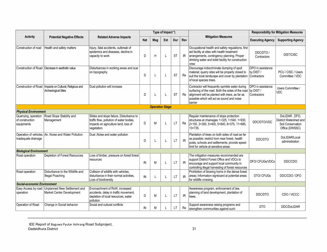
Table 7.3 Adverse Impacts and Proposed Mitigation Measures 30
Table 7.4 Cost Estimate For Environmental Enhancement and Mitigation Measures 35
Table 7.5 Environmental Monitoring Cost 36
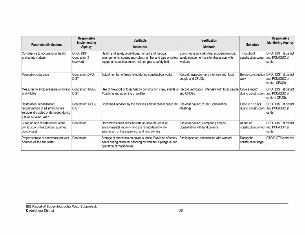
Table 7.6 Compliance Monitoring For Baguwa Pyutar Ashrang Road Construction Work 37
Table 7.7 Impact/Effect Monitoring For Baguwa Pyutar Ashrang Road Construction Work 39
_______________________________________________________________________________________________IEE Report of Baguwa Pyutar Ashrang Road Subproject,
Lalitpur District iii
ABBREVIATIONS
ADB Asian Development Bank amsl Above mean sea level AP Affected Person BG Building Group Ch Chainage CBO Community Based Organization CDC Compensation Determination Committee CDO Chief District Officer CEA Country Environmental Analysis CGI Corrugated Galvanized Iron CF Community Forest CFUG Community Forest Users Group CISC Central Implementation Support
Consultant CITES Convention on International Trade in
Endangered Species of Flora and Fauna DADO District Agriculture Development Office DDC District Development Committee DFID Department for International
Development DFO District Forest Office/Officer DG Director General DIST District Implementation Support Team DIT District Implementation Team DoLIDAR Department of Local
Infrastructure Development and Agricultural Roads
DPO District Project Office DPCC District Project Coordination Committee DRSP District Road Support Programme DSCO District Soil Conservation Office DTO District Technical Office DTMP District Transport Master Plan EA Environmental Assistant/Assessment EARP Environmental Assessment and Review
Procedures ES Environmental Specialist EIA Environmental Impact Assessment EMP Environmental Management Plan EMS Environmental Management Section EPA Environmental Protection Act EPR Environmental Protection Rules ESD Environment Screening Document FGD Focus Group Discussion GAP Gender Action Plan GoN Government of Nepal GIS Geographical Information System Ha Hectare HH Household IEE Initial Environmental Examination IPDP Indigeneous People Development Plan
IUCN International Union for Conservation Nature
Km Kilometer LDO Local Development Officer LEP Labour based, Environment friendly and
Participatory LEST Livelihood Enhancement and Skill
Training LRMP Land Resource Management Project M meter MoU Memorandum of Understanding MoE Ministry of Environment MoST Ministry of Science and Technology Ml Milliliter MLD Ministry of Local Development NGO Non-Governmental Organization NRs Nepali Rupees NTFPs Non timber forest products OFID OPEC Fund for International
Development OP Operational Plan OPEC Organization of Petroleum Exporting
Countries PAM Project Administrative Memorandum PCC Plain Cement Concrete PCU Project Coordination Unit RBG Road Building Group RCC Reinforced Cement Concrete RCIW Rural Community Infrastructure Works REA Rapid Environmental Assessment RES Rapid Environmental Screening RIDP Rural Infrastructure Development Project RP Resettlement Plan RRRSDP Rural Reconstruction and
Rehabilitation Sector Development Program
RS Resettlement Specialist SAP Social Action Plan SF Social Funding SA Social Appraisal SDC Swiss Agency for Development and
Cooperation SM Social Mobilizer SMC Social Mobilization Coordinator SMO Social Mobilization Officer TA Technical Assistance ToR Terms of Reference TWS Technical Walkover Survey VDC Village Development Committee VICCC Village Infrastructure Construction
Coordination Committee ZoI Zone of Influence
_______________________________________________________________________________________________IEE Report of Baguwa Pyutar Ashrang Road Subproject,
Lalitpur District iv
NAME AND ADDRESS OF THE PROPONENT
Name of Proposal (Upgrading of) Baguwa-Pyutar-Ashrang Road, Lalitpur District, Nepal
Name and Address of Proponent
District Development Committee (DDC), District Technical Office (DTO), Lalitpur District Phone No: 01-5551637, 01-5538789
Name of Preparer
Mr. Manoj Kumar Shah (Deputy Team Leader) Mr. Man Kumar Rai (Social Development Specialist)
Data Collection and Support Mr. Ram Charitra Mandal (Team Leader, DIST) Mr. Manoj Kumar Shah (Deputy Team Leader, DIST) Mr. Man Kumar Rai (Social Development Specialist, DIST) Mr. Narendra Kumar Rai (Sub-Engineer, DIST) Mr. Ram Prasad Subedi (Assistant Sub-Engineer)
_______________________________________________________________________________________________IEE Report of Baguwa Pyutar Ashrang Road Subproject,
_______________________________________________________________________________________________IEE Report of Baguwa Pyutar Ashrang Road Subproject,
Lalitpur District vi
ls=dL cg'dflgt nfut g]?= ^!&)*)* nfUg] b]lvG5 . The total project cost is NRs. 98,840,619 and cost per km is NRs. 6,170,808 and bridge is NRs. 40,914,109.
_______________________________________________________________________________________________IEE Report of Baguwa Pyutar Ashrang Road Subproject,
_______________________________________________________________________________________________IEE Report of Baguwa Pyutar Ashrang Road Subproject,
Lalitpur District x
EXECUTIVE SUMMARY
Background
Government of Nepal has received financial assistance from ADB, SDC, DFID and OFID for implementation of the Rural Reconstruction and Rehabilitation Sector Development Program (RRRSDP). The RRRSDP aims for reconstruction and rehabilitation of rural infrastructures damaged in the twenty conflict affected districts of the country. The Proposed 16.17 km long Baguwa-Pyutar-Ashrang Rural Road in Lalitpur District is one of the Subprojects selected under the RRRSDP. It is an existing earthen road proposed for upgrading in gravel standard. Project Proponent
The 'Proponent' of the proposed Subproject (Proposal) is District Development Committee (DDC)/ District Technical Office (DTO), Lalitpur. Ministry of Local Development (MoLD) is the 'Concerned Agency' for approving the IEE study. Objectives of the IEE Study
The objectives of the IEE study is to identify the impacts on the physical, biological, socio-economic and cultural environment of the project influence area from construction and operation of the Proposal, and recommend site-specific adverse impact mitigation measures and beneficial impact augmentation measures and sure whether the IEE or EIA is required for the proposed road sub-project. Relevancy of the Proposal
The project area lies in South-Western part of Lalitpur District. It links with Kanti Rajmarga. This road helps to reduce travel time and cost of local people to access other part of the country. The area has high potential in production of vegetables like Ginger, Raddish, Potato, Cabiage, Cauliflower, Tomato; fruits like Banana, Guava; and milk. The proposed road will enhance access to market and social services to the people of the area, and will significantly contribute in their socio-economic development. Better access will also open door to new development opportunities. It helps to connectivity to the other parts of the country, all weather serviceability, safety after upgrading the road in gravel standard. Access shall also attract other development infrastructures and open door to further development opportunities in the area. Study Methodology
The IEE study has been conducted through review of secondary information collected from relevant agencies, and primary information collected from the field survey in July 2009. The survey methods included walk-through survey along the existing alignment with checklists, conduction of sample household survey, organizing focus group discussions (FGD) in the related VDCs, and information supplemented by the resettlement and technical team of the Subproject. The IEE report has been prepared following the Environmental Protection Act, 1997 and Environmental Protection Rules, 1997 (second amendment 2007) of the Government of Nepal (GoN); and Environmental Assessment Guidelines, 2003, and Safeguard Policy Statement, 2009 of ADB. The report follows the Terms of Reference for IEE Study approved by MoLD on 22/01/2066 BS. Brief Description of the Subproject
The proposed road lies at the remote South-westrn part of Lalitpur district. This road links remots VDCs with Kanti Rajpath and District headquarter. Total length of road is 16.17 km. The road is currently earthen surface and vehicles ply seasonally. This road starts from Baguwa bazar of Malta Village Development Committee (VDC) and passes through Pyutar VDC ends at Chainpur Bazaar of Asrang Village Development Committee (VDC).The total project cost is NRs. 98,840,619 and cost per km is NRs. 6,170,808 and bridge is NRs. 40,914,109. Existing Environmental Condition The road starts from Baguwa of Malta VDC at 1480m amsl and end at Tallo Chainpur of Ashrang VDC 790m amsl. Various kinds of rock such as quartzite, schist, selate, etc. were observed along the road alignment. Generally, alluviam, residual and clay mixed sandy soil are found along the road alignment. Main waterbodies found across the road alignment are Khani Khola and Ghatte Khola. Ambient air and water quality in the proposed project area is found to be good and there’s also no noise pollution. The road mainly passes through cultivated land, barren land, forest and settlements.
_______________________________________________________________________________________________IEE Report of Baguwa Pyutar Ashrang Road Subproject,
Lalitpur District xi
The dominant forest species found in the road alignment are Sal (Shorea robusta), Chilaune (Schima wallichii), Uttis (Alnus nepalensis), Khote Salla (Pinus roxburghii), Khirra (Sapium insigne), Kutmero (Litsea monopelata) and Katus (Castanopsis indica). Barking deer (Muntiacus muntijak), Jackal (Canis aureus), Monkey (Macaca mulatta), Wild Pig (Sus scrofa), Jungle Cat (Felis chaus), Musa (Rattus rattus), Squirrel (Ratufa spp.), Nyauri Musa (Herpestes Edwardsi), Fox (Vulpes Montana) are the wild animals reported in the forests of proposed road area. Similarly birds are Kalij Pheasant (Lophura lencomelana), Pigeon (Columba livia), Crow (Corvus splendens), Dove - Dhukur (Streptopelia spp.), Kokale (Dendrocitta formosae), Jungle fowl (Gallus gallus) etc. The road does not fall under any protected or buffer zone area. There are 11 major settlements along the ZoI of the proposed road alignment in Baguwa, Pyutar and Ashrang VDCs with total population of 1948 persons (379 households) and average family size of 5.14. Diverse ethnic groups such as Chhetri, Brahman, Tamang, Magar and occupational caste (Damai, Kami). The main occupation of all people residing within the ZoI of the proposed road alignment is agriculture and livestock. Due to limited transportation facilities, agriculture farming is not enough for subsistence level. Therefore, people are carrying out other economic activities like majority of the people work as labour and porters while some people work in government and non government organizations and a few are doing business. Moreover, significant section of the economically active male population also migrates to various places including Kathmandu and abroad for employment. Major Environmental Impacts Beneficial Impacts
The immediate benefit from this road Subproject is employment opportunities. The implementation of Subproject requires about 121327 person days, with 10982 for skilled and 110345 for unskilled labor and for bridge 33640 person days with 9092 for skilled and 24548 unskilled labor. The project will give priority to local poor, dalit, vulnerable groups and women. Other beneficial impacts include enhancement of local business, development in skills of local people from skill developing training, awareness raising training and involvement in the construction of the project. During operation stage of road, the people from the Zone of Influence (ZoI)1 will get easy and fast accessibility to markets, social services and other regions of the country. This road links with Kanti Rajpath road and it helps to connect to the Hetauda of Makanwapur District. This road helps to reduce travl time and cost of local people to access other part of the country. This will ensure better economic condition and food security of the people living in the ZoI of the project area. Moreover this will promote the small agro based industries that uses local resources. Easy access and opportunity of better transportation system will develop other sectors like education, health, communication, market, banking and other socio-economic sectors. This will increase the overall living condition of the people living in ZoI of project area. The better land network will result in increased land price which will be beneficial for land owners. Adverse Impacts
During the road construction, the cutting of slopes and consequently disposal of soil and earth material, operation of quarries might result in on erosion and landslide during construction and operation. Futhermore, spoils generated during construction can create the water pollution to the nearby water sources.
During road widening and construction 0.529 ha. of cultivated land, 0.837 ha.of forest land need to be acquired. 36 nos of different type of trees will be cleared. Also during construction of road there might be possible impacts on wildlife as workers might harass/ poaching the wildlife in the nearby forests, however, such effects are very minimum.
Water supply pipelines (0+712, 1+110, 1+514, 1+830, 1+960, 2+800, 2+940, 3+356, 3+990, 5+550, 7+800, 11+150), Foot trail (2+300, 6+200, 6+900, 7+325, 8+362, 11+300), Elecrtic pole (3+450, 7+200, 13+670, 14+745) Irigation cannal (1+000, 6+250, 13+045-13+120), Water Mill(11+850), School (3+400, 7+600) and 10 house will be damaged during road construction. Labours and local people are prone to health effects and accidents relating to construction activities.
During operation stage, vehicular movement, monsoon rain and grazing of animals on the unstable slopes might result in slope instability and hence erosion and landslides might occur. The flowing water on the side drain of the road might cause erosion of soil on adjacent agricultural land. Vehicular emissions will result in air and noise pollution. Because of easy accessibility to the forest areas will deplete forest resources and wildlife. New settlement, bazaar area will be expanded and this may increase encroachment of the RoW.
1 ZoI is one and half hour walking distance from the road and areas of related VDCs.
_______________________________________________________________________________________________IEE Report of Baguwa Pyutar Ashrang Road Subproject,
Lalitpur District xii
Mitigation Measures
The various benefit augmentation measures and adverse impact mitigation measures have been proposed in the report to make this project environment friendly. Other than land donated by local people for the projects, adequate compensation will be provided to affected poor and marginalize household for all the lands that need to acquire. The construction of road will be based on contractor and Labour-based, Environment friendly and Participatory (LEP) Approach. Affected families will be given high priority for employment and skill development trainings. Necessary measures will be taken to reduce the adverse effects that might arise from site clearance, cutting of slopes, disposal of spoils and quarrying activities. Necessary trainings and awareness programs will be conducted. Necessary measures will be adopted for protection of flora and fauna. At construction site, the workers will be provided insurance, first aid facilities and safety equipments. Compensatory plantation of trees will be done in forest areas at 1:25 ratio + 10 % and in private land at 1:1 ratio. Protected species will be given emphasis for plantation. Proper maintenance and proper drain system will be provided to prevent accumulation of water on the nearby agricultural lands during operation. Adequate road safety measures will be provided to minimize road accident. Affected private houses, Water mill, Irrigation Canal, Water Supply Pipeline, Foot Trail, Access road, School, Electric Pole will be reinstated, relocated, compensated. The cost will be included in detail project report. Environmental Management Plan
Environmental management plan is prepared to ensure the implementation and monitoring of mitigation measures for minimizing adverse impacts and maximizing the beneficial impacts. The necessary mitigation measures together with environmental monitoring process and responsible bodies for environmental monitoring have been identified. Similarly, for environmental monitoring various sections of physical, biological, socio-economic and cultural environment have been identified to generate useful information and improves the quality of implementation of mitigation measures. The cost for implementing environmental management plan has been identified as follows:
SN. Description Amount (NRs.) Remarks 1 Environmental awareness raising training
and other training 50000.00 To be included in project
cost 2 Insurance of workers 300000.00 To be included in BoQ 3 Bio-engineering 3000000.00 (Cost will be finalized after
detail design) To be included in BoQ
4 Resettlement and Land Acquisition 5500000.00 To be included in Resettlement plan
5 Restoration or relocation of affected infrastructures, Spoil management, Reinstate of quarry, stockpiling etc.
500,000.00 To be included in BoQ
6 Compensatory Plantation cost 150,000.00 To be included in Environment cost
7 Social Action Plan Cost 700000.00 To be included in Environment plan.
8 Occupational health and safety, Information signboard
500000.00 To be included in BoQ
9 Monitoring 2,00,000.00 To be included in Environment cost
Total 11,150,000.00 Conclusion and Recommendation
The identified environment impacts will be seen in limited small areas and mainly during construction period. The implementation of proposed mitigation measures for identified adverse impacts will minimize as well as mitigate the adverse impacts on environment. The Resettlement Plan and compensation to the affected households should be ensured. The implementation of measures as described in environmental management plan will mitigate the negative impacts on physical, biological, socio-economic and cultural environment. Therefore, this IEE is sufficient for approval of the proposed sub-project, and recommended for implementation with incorporation of mitigation measures and environmental monitoring plan. Therefore, the proposed Subproject does not require Environmental Impact Assessment.
__________________________________________________________________________________________________ IEE Report of Baguwa Pyutar Ashrang Road Subproject,
Lalitpur District 1
1. INTRODUCTION
1.1 Background
1. The Rural Reconstruction and Rehabilitation Sector Development Program (RRRSDP) focuses on immediate post conflict development priorities for accelerated poverty reduction and inclusive development, thereby enhancing the effectiveness and efficiency of the delivery of public services, and improving access of rural people to economic opportunities and social services. The Program is financed by the Government of Nepal (GoN), Asian Development Bank (ADB), Department for International Development (DFID), Swiss Development Cooperation (SDC), Nepal and OPEC Fund for International Development (OFID). The Program covers twenty districts spread over the country. Department of Local Infrastructure Development and Agricultural Roads (DoLIDAR) under the Ministry of Local Development (MLD) is the executing agency (EA). The District Development Committees (DDCs) / District Technical Office (DTO) are the Project Implementing Agencies. The DDC/DTO is supported by District Implementation Support Team (DIST) with engineering, safeguards and social mobilization responsibilities.
2. Lalitpur District is one of the project districts under RRRSDP. This Proposal is for upgrading in gravel standard of the 16.17 km long Buguwa- Pyutar- Ashrang Road in Lalitpur District.
1.2 The Name and Address of Proponent
Name of Proposal (Upgrading of) Baguwa-Pyutar-Ashrang Road Subproject, Lalitpur District, Nepal
Name and Address of Proponent District Development Committee (DDC), District Technical Office (DTO), Lalitpur Phone No: 01-5551637; 01-5008031
1.3 Relevancy of the Proposal
3. The Project area is located at remote and underdeveloped south-west part of Lalitpur District. This road links with Kantirajpath feeder road. This road also links with Hetauda and Makawanpur District. The area has high potential in production of vegetables like Ginger, Raddish, Potato, Cabiage, Cauliflower, Tomato; fruits like Banana, Guava; and milk. The upgrading of road will enhance access to market and social services to the people of the area, and will significantly contribute in their socio-economic development. The fruits and vegetables produced in the project area will get access to market in Patan Bazar and Kathmandu. Better access will also open door to new development opportunities. It helps to connectivity to the other parts of the country, all weather serviceability, safety after upgrading the road in gravel standard. Access shall also attract other development infrastructures and open door to further development opportunities in the area.
1.4 Need and Objectives of the IEE Study
4. Need: An IEE study of the Proposal is a legal requirement according to the Environment Protection Act, , 2053 BS (1997 AD); and Environment Protection Rule, 2054 BS (1997 AD) of GON; and according to the provisions of the Environmental Assessment Guidelines, 2003; and Safeguard Policy Statement, 2009 of ADB.
5. Objectives: The main objective of the IEE study is to identify the impacts from the construction and operation of the Proposal on the physical, biological, socio-economic and cultural environment of the Subproject area. The IEE study recommends practical and site specific environmental mitigation and enhancement measures, prepare and implement environmental management plan and make sure whether the IEE or EIA is required for the proposed road sub-project.
1.5 Methodology Adopted
6. The IEE study has followed the provisions of the EPA, 1997 and EPR, 1997, the provisions of ADB and approved ToR for IEE Study by MoLD on 22/01/2066 BS. It follows methodology suggested in the approved Terms of Reference for IEE Study (please refer Annex I). For the collection of environmental features related to bio physical environment, maximum 100 meter distance observable from the centre of the road alignment was taken as an influence area and socio-economic and cultural environment was taken of ZoI (one and half hour walking distance from the centre line of the road) information of the Subproject area. The IEE study has been conducted through review of secondary information collected from relevant agencies, and primary information collected from the field survey in Jan 2011. Field survey, sample household survey, organization of Focus Group Discussions in the related VDCs was carried out and necessary information was collected.
__________________________________________________________________________________________________ IEE Report of Baguwa Pyutar Ashrang Road Subproject,
Lalitpur District 2
The DDCs officials, VDCs and Community Groups were also contacted to verify information to solicit their concerns. Based on the analysis of information the impacts have been predicted, identified and evaluated, mitigation measures prepared and monitoring plan has been developed.
1.6 Public Consultation
7. In order to ensure the involvement of concerned stakeholders, following procedures were followed: � Publication of Public Notice- a 15 days public notice was published on 11/02/2066 in the Naya Patrika
newspaper (see Annex V) seeking written opinion from the concerned VDCs, DDC, schools, health posts and related local stakeholders. A copy of the public notice was also affixed in the offices of the above mentioned organizations and deed of enquiry was collected (see Annex VII).
� Interaction with local communities and related stakeholders like District Forest Office, District Soil Conservation Office, District Agricultural Development Office and others were carried out during field survey to collect the public concerns and suggestions. Focus Group Discussions were conducted in all three VDCs to collect and requested their suggestions on protection of bio-physical and socio-economic environment in the Zone of Influence (ZoI) of the road. Summary of minutes of meeting is given in Table 2.1.
� Draft IEE report was kept at information center of DDC, Malta, Pyutar and Ashrang VDCs for public disclosure. Information was also disseminated through person to person contacts and interviews and group discussions. Recommendation Letters for implementation of the Proposal were also obtained from all the concerned VDCs (see Annex VI).
Table 2.1: Summary of FGD Meeting Conducted Under IEE Study
Location Date
No. of Participants Issues/Suggestions Decision Male Female
Baguwa Bazar 2066/05/12 7 2 • FGD program disseminated information on the project to stakeholders.
• Construction activities should be done with no environment impact, if not less environment impact.
• Mitigation measures or minimization should be done during road construction.
• Issues/suggestions raised during the FGD meetings will be addressed in the mitigation measures and benefit augmentation measures.
Pyutar Bazar 2066/05/14 14 3
Ashrang VDC’s Bulding in
Ashrang Bazar
2066/05/16 11 7
8. The approved IEE report is accessible to interested parties and general public through the websites of ADB and MoLD/DoLIDAR. The copy of approved IEE report has been distributed to following offices: 1. District Development Committee, Lalitpur 2. District Technical Office, Lalitpur 3. District Project Office, Lalitpur 4. District Implementation Support Team, Lalitpur 5. Ministry of Local Development, Environment Management Section 6. Department of Local Infrastructure Development and Agricultural Roads 7. Project Coordination Unit, RRRSDP 8. Asian Development Bank, Nepal Resident Mission
__________________________________________________________________________________________________ IEE Report of Baguwa Pyutar Ashrang Road Subproject,
Lalitpur District 3
2. DESCRIPTION OF THE PROPOSAL
9. The proposed Baguwa –Pyutar- Ashrang road sub-project lies in the South-Western part of Lalitpur district of Central Development region of Nepal. This Subproject starts from Baguwa of Malta village Development committee (VDC) and ends at Tallo Ashrang of Ashrang VDC. The road is currently earthen surface and vehicles ply only seasonally. This road also link with Kantirajpath. (see in Figure 1.1 and 1.2). Widening, geometric correction and grade improvement, slope stabilization, graveling, and cross drainage works are planned to implement under the proposed upgrading works of the road. In this road at Khani khola (Ch. 1+077) single span steel truss bridge is proposed. The total project cost is estimated excluding bridge at average of NRs. 98,840,619.00 and cost per km is NRs. 6170808.00 and bridge is NRs. 40,914,109.
Salient Features of the Subproject:
1. Name of the Project : Upgrading of Baguwa -Pyutar -Ashrang Road Subproject
1.1 Project Components : Road and Bridge
1.2 Project Activities : Construction Stage Site clearance, Gravelling work, Structures work (toe wall, retaining wall, breast wall,), Earthwork, Bio-engineering, Cross drainage works and Side drain works.
Operation Stage Maintenance Works
2. Location 2.1Geographical Locations
2.1.1 Start Point : Baguwa of Malta VDC. 2.1.2 End Point : Tallo Chainpur of Ashrang VDC.
2.2 Geographical Feature 2.2.1 Terrain : Hilly
2.2.2 Altitude : Starting point 1480m amsl, and end point 790m amsl. 2.2.3 Climate : Sub-Tropical 2.2.4 Soil : Hard soil, ordinary soil, soft rock, Medium rock.
3. Classification of Road : District Road (Rural Road Class B)
Salient features of Khani Khola Bridge SALIENT FEATURES Name of the Project : Detail Engineering Survey and Detail Design of Rural Road
Steel Truss Bridge Over Khani Khola Location Development Region : Central Zone : Bagmati District : Lalitpur Village / Town : Right Bank Axis Baguwa V.D.C (Ward no. 2)
Left Bank of Bridge Axis Pyutar V.D.C (Ward no.1) Name of the Road : Baguwa-Pyutar- Ashrang Road Chainage of the Bridge site : About 41 Km from Tika Bhairab bazaar Geographical Location Easting : 629372.20 m Northing : 3042147.97 m Classification of Road : District Road Type of Road Surface : Earthen Terrain / Geology : Hilly Economical Information Construction Cost NRs. : 40,914,109 Structure Total length of the Bridge : 45.00m (steel Truss Bridge) No of span : 1.00 Total width of the bridge : 4.75 m center to centre of Truss Width of Carriage way : 3.50 m Width of Footpath : No foot path Catchments Area : 92.14 sq Km Type of Structure : Simply Supported steel truss Bridge Type of Bearing : Elastomeric Pad Type of Abutment : RCC (Gravity Type) Type of Foundation : Open Foundation Design Data Live Load : IRC Class ‘A’ Net bearing capacity of soil : Varying at different depths Design Discharge : 758.09 m3/sec Mean Scour Depth : 3.089 m below H.F.L Highest Flood Level : 797.395 m Lowest Bed Level : 793.695 m Concrete Grade : M25 – approach slab and caps M20 - Substructure Reinforcement Bars : Fe 415 (Tor Steel) / TMT Approach Slab RCC (3.0 m ) River Training Works Wing Walls
__________________________________________________________________________________________________ IEE Report of Baguwa Pyutar Ashrang Road Subproject,
Lalitpur District 5
Employment generartion: Total employment Skilled Unskilled
33640 9092 24548
2.1 Construction Approach and Activities
10. The construction approach will be Contractor Modality and Labour Based Environment Friendly and Participatory Approach (LEP) wherever possible. Contractor modality is proposed due to lack of sufficient time for construction.
11. Activities included during the road construction are: Site clearance, Pavement work, Structures (Toe wall, retaining wall etc.), Earthwork, Bioengineering, Gravelling, Cross drainage works ,Side drain works and Bridge work.
2.2 Proposed Schedule for Implementation of Subproject
12. Following Table 1.1 shows the pcroposed implementation schedule of the Subproject: Table 2.1: Sub-project implementation schedule
SN Activity 2009 2010 2011 2012 I II III IV I II III IV I II III IV I II
1 Detailed survey, design and estimate
2 Preparation of resettlement plan
2.1 Life skill and income generation training
3 Environment Assessment and implementation
3.1 IEE report preparation and approval from MoLD
3.2 Implementation of EMP
3.3 Environmental monitoring
4 Work implementation
4.1 Civil construction work by contractors
4.2 Civil construction work by RBGs
Note: I - January, February, March II - April, May, June III - July, August, September IV - October, November, December
__________________________________________________________________________________________________ IEE Report of Baguwa Pyutar Ashrang Road Subproject,
Lalitpur District 6
Figure 2.1 Map of Nepal showing the location of Baguwa-Pyutar-Ashrang road Subproject in Lalitpur District
Ch. 0+000
Ch.16+170
Showing the alignment of Baguwa-Pyutar-Ashrang Road Sub-Project
__________________________________________________________________________________________________ IEE Report of Baguwa Pyutar Ashrang Road Subproject,
Lalitpur District 7
Figure 1.2: Alignment of Baguwa -Pyutar-Ashrang Road Subproject
16+170
__________________________________________________________________________________________________ IEE Report of Baguwa Pyutar Ashrang Road Subproject,
Lalitpur District 8
3. REVIEW OF RELEVANT ACTS, REGULATIONS AND GUIDELINES
13. The IEE study has followed the provisions of following acts, regulations and guidelines of Government of Nepal and ADB to ensure conservation of environment during proposal implementation and operation.
Table 3.1: Review of Environmental Acts, Regulations and Guidelines
SN Environmental Acts,
Regulations and Guidelines Description of Requirements
1 Three Years Interim Plan, 2007/08-2009/10, GoN
Requires all projects will be formulated and constructed based on methods that optimally utilize the local skill and resources and generate employment opportunities.
Any development project, before implementation, shall pass through environmental assessment, which will be either IEE or an EIA depending upon the location, type and size of the projects.
The EPR and its schedules clearly provide various step-wise requirements to be followed while conducting the IEE study. It also obliges the Proponent to timely consult and inform the public on the contents of the proposal and IEE study.
Requires decision makers to take account of all forest values, including environmental services and biodiversity, not just the production of timber and other commodities. It includes several provisions to ensure development, conservation, management, and sustainable use of forest resources based on approved work plan.
5 Forest Rules, 2051 BS (1995 AD), GoN
Elaborates legal measures for the conservation of forests and wildlife. Expenses incurred for cutting trees and transportation shall be borne by proponent.
6 Batabaraniya Nirdesika (Nepal; MLD), 2057, GoN
The directive is focused in the practical implementation of small rural infrastructures through the minimization of environmental impacts. This directive includes the simple methods of environmental management in the different phases of the project cycle.
7 Local Self Governance Act 2055 BS (1999 AD) (1999) and Regulation 2055 BS (1999 AD), GoN
Empowers the local bodies for the conservation of soil, forest and other natural resources and implements environmental conservation activities
8 Land Acquisition Act, 2034 BS (1977 AD) and Land Acquisition Rules, 2026 BS (1969 AD), GoN
Specifies procedural matters on land acquisition and compensation
9 National Environmental Impact Assessment Guidelines, 1993 (2050 BS), GoN
Provides guidance to project proponent on integrating environmental mitigation measures, particularly on the management of quarries, borrow pits, stockpiling of materials and spoil disposal, operation of the work camps, earthworks and slope stabilization, location of stone crushing plants etc.
10 APPROACH for the Development of Agricultural and Rural Roads, 1999 (2055 BS), GoN
Emphasizes labor based technology and environmental friendly, local resource oriented construction methods to be incorporated actively in rural infrastructure process.
For preparation of environmental assessments of future subprojects under Rural Reconstruction and Rehabilitation Sector Development Program (RRRSDP), this EARP includes: i) The process to be adopted while preparing environmental reports, ii) the potential environmental impacts that could result from undertaking the Project based on the Initial Environmental Examinations (IEEs) of sample core subprojects; iii) the proposed mitigation measures to avoid the identified impacts; iv) institutional capacity assessment and strengthening arrangements; v) legal framework for environmental assessment, domestic and the Asian Development Bank (ADB) environmental assessment and review procedures; and finally vi) the approaches to be adopted during implementation of the Project in order to ensure that environmental aspects are dealt with in a comprehensive manner.
12 Reference Manual for Environmental and Social Aspects of Integrated Road
Development, 2003 (2060
BS), GoN
Suggests stepwise process of addressing environmental and social issues alongside the technical, financial and others
__________________________________________________________________________________________________ IEE Report of Baguwa Pyutar Ashrang Road Subproject,
Lalitpur District 9
13 Environmental Assessment Guidelines, 2003, ADB
Requires that environmental considerations be incorporated into ADB operations where environmental assessment is the primary administrative tool to integrate environmental considerations into decision-making of all types of development initiatives
14 Safeguard Policy Statement, 2009, ADB.
ADB’s Safeguard Policy Framework consists of three operational policies on the Environment, Indigenous people and Involuntary resettlement. It requires that (i) impacts are identified and assessed early in the project cycle, (ii) plans to avoid, minimize, mitigate or compensate for the potential adverse impacts are developed and implemented and (iii) affected people are informed and consulted during project preparation and implementation.
15 The Interim Constitution of Nepal, 2063 (2007).
Has provision of right regarding environment - Every person shall have the right to live in clean environment.
16 The Labor Act, 2048 BS (1992 AD)
Regulates the working environment and deals with occupational health and safety.
17 Child Labor (Prohibition and Regulation) Act, 2056 (2000)
No child having not attained the age of 14 years shall be engaged in works as a laborer.
__________________________________________________________________________________________________ IEE Report of Baguwa Pyutar Ashrang Road Subproject,
Lalitpur District 10
4. BASELINE ENVIRONMENTAL CONDITION IN THE SUBPROJECT AREA
14. Baseline information on the existing physical, biological and socio-economic and cultural environment of the zone of influence (ZoI) of the proposed Subproject is described in this Chapter.
4.1 Physical Environment
4.1.1 Topography
15. The elevation of the starting point of the road at Baguwa is 1480m amsl and at Ashrang is 790m amsl and Bridge is 794 m amsl. The road alignment passes through the upper valley slopes and middle hills. The existing grade of the road varies from 2% to 18%. Major portion of the road passes along the south-east facing slope.
4.1.2 Geology and Soil Type
16. Geologically, the road alignment lies in Mahabharat range from Baguwa to Ashrang. Soil type along the alignment Colluvial, and Residual soil. Following Table 4.1 presents the geological features recorded along the road alignment.
Table 4.1: Geological Features along the Road Alignment
SN Section Chainage Length
(m) Elevation
(m) Aspect
Material Types
1 Baguwa 0+000-1+060 1660 1432 to 1385
North Colluvial, and
Residual
2 Gadhibhanjyang 1+060- 3+980 1540 1385 to 1360
3 Pyutar 3+980- 10+640 1300 1360 to 1180
4 Ashrang 10+640- 11+500 2300 1180 to 960 South
5 Tallo Ashrang 11+500- 16+000 3200 960 to 985 Source: Field Survey , 2010
4.1.3 Land Use
17. Land use pattern of the area through which the road passes have been classified into three types: Agriculture land, Barren land and Forest as shown in Table 4.2. Table 4.2: Summary of Land Use Pattern along the Road Alignment
Type of land
Chainage Length (m)
Existing width (m)
Additional Width (m)
Existing Area (Ha)
Additional Area (Ha) From To
Agriculture Land
0+600 0+958 358 4 1 0.14 0.03
4+718 6+191 1473 4.5 0.5 0.66 0.07
6+230 6+334 104 4 1 0.04 0.01
6+570 7+459 889 3.5 1.5 0.31 0.13
9+111 9+590 479 4 1 0.19 0.04
10+373 10+568 195 4.5 0.5 0.08 0.009
11+168 11+577 409 4 1 0.16 0.04
12+285 14+375 2065 4 1 0.82 0.20
Sub-Total
0.529
Barren Land
4+634 4+718 84 5 0 0.042 0
5+897 5+997 97 5 0 0.048 0
6+566 6+661 1095 5 0 0.54 0
Sub-Total
0
Forest Area
0+000 0+600 600 4 1 0.24 0.06
0+994 4+540 3546 4 1 1.14 0.35
6+444 6+551 107 3.5 1.5 0.03 0.01
6+722 6+801 79 4 1 0.03 0.007
7+270 9+075 1805 4 1 0.72 0.18
9+535 10+173 638 4 1 0.025 0.06
10+568 11+168 600 4 1 0.24 0.06
11+513 12+285 772 3.5 1.5 0.27 0.11
Sub-Total
0.837
Total Source: Field Survey 2010
__________________________________________________________________________________________________ IEE Report of Baguwa Pyutar Ashrang Road Subproject,
Lalitpur District 11
4.1.4 Climate
18. Baguwa-Pyutar-Ashrang road lies in the sub-tropical and temperate climatic region. Generally, rainy season starts from June and ends in September. The meteorological record shows unevenly distributed monsoon rain in the project area with the total average annual rainfall is 11120 mm. The general climatic condition is cold in winter and hot in summer with average minimum temperature of 5° C and average maximum temperature of 30°C. (Source: District Profile of Lalitpur, 2006.) 4.1.5 Hydrology and Drainage System
19. There are 10 numbers of rivers and several small seasonal streams (Kholsi) along the road. The road block some time due to high debris flow in different rivers. The proposed summary of the cross drainages along the road alignment is given in Annex XIV. Table 4.3 Summary of streams and rivers along the road alignment
SN Chainage Name of the Stream Width (m) Type of Structure Necessary
1 1+100 Khani Khola 15 Bridge proposed
2+050 Gadibhanjyang Khola 14 Hume Pipe
2 5+500 Khahare Khola 13 Hume Pipe
3 6+300 Pyutar Khola 11 Hume Pipe
4 6+500 Khoran Khola 12 Hume Pipe
5 9+250 Khaireni Khola 18 Cause Way
6 10+300 Gairi Khola 13 Cause Way 7 10+750 Ghatte Khola 12 Cause Way 8 11+650 Lukuni Khola 17 Cause Way 9 12+700 Asrang Khola 19 Cause Way
10 13+350 Bhalu Khola 16 Cause Way Source: Field Survey , 2010
4.1.6 Soil Erosion and Sedimentation
20. The stability of slopes along the road corridor depends upon slope angle, the material constituting the slope, rock discontinuities and hydrological conditions. The road alignment passes through landslides at different chainages which are gien below in Table. The main causes for occurring slides are rock weathering, precipitation and surface runoff. Table 4.4: Existing Landslides and unstable areas along the Road Alignment
Chainage Land Use Pattern Geological Problem 1+325 Forest Area Landslide
1+540 Cultivated slopes Landslide
1+930 Cultivated slopes Landslide
2+150 Cultivated slopes Landslide
3+300 Cultivated slopes Slumping
5+400 Forest Area Gully erosion due to overflow from the blocked culvert
5+840 Forest Area Gully erosion from culvert outlet. Side slope undercut
8+375 Forest Area Landslide
11+685 Forest Area Landslide
13+735 Cultivated land Erosion Source: Field survey, 2010
4.1.7 Air, Noise and Water Quality
21. The air, noise and water quality are not measured or tested, but are observed to be within acceptable limit. Dust emission during vehicle operation has been a nuisance which becomes more significant during dry and winter seasons.
4.2 Biological Environment
22. This alignment does not pass through any national park, protected area or their buffer zones.
4.2.1 Vegetation
23. The dominant forest and fodder species reported in the road alignment are Sal (Shorea robusta), Chilaune (Schima wallichii), Uttis (Alnus nepalensis), Khote Salla (Pinus roxburghii), Khirra (Sapium insigne), Kutmero (Litsea monopelata), and Katus (Castanopsis indica). Other plant species found within ZoI of the sub-project are Pipal (Ficus religiosa), Lapsi (Choerospondias axillaris), Koiralo (Bahunia
__________________________________________________________________________________________________ IEE Report of Baguwa Pyutar Ashrang Road Subproject,
24. Barking deer (Muntiacus muntijak), Jackal (Canis aureus), Monkey (Macaca mulatta), Wild Pig (Sus scrofa), Jungle Cat (Felis chaus), Musa (Rattus rattus), Squirrel (Ratufa spp.), Nyauri Musa (Herpestes Edwardsi), Fox (Vulpes Montana) are the wild animals reported in the forests of project area. Similarly birds are Kalij Pheasant (Lophura lencomelana), Pigeon (Columba livia), Crow (Corvus splendens), Dove - Dhukur (Streptopelia spp.), Kokale (Dendrocitta formosae), Jungle fowl (Gallus gallus) etc. 4.2.3 Aquatic Life
25. Aquatic life mainly found in the rivers is Hile and Budona fish. Endangered and Protected Species
26. Floral Species: Sal (Shorea robusta) is listed as protected plant species and forest products according to Forest Act 1993 which is categorized into timber banned for felling, transportation and export for commercial purposes. Lapsi (Choerospondias axillaris) is listed as ‘Rare’ by IUCN category.
27. Faunal Species: Monkey (Macaca mulatta) and Squirrel (Ratufa spp.) are listed in CITES Appendix II. Jackal (Canis aureus) is listed in CITES Appendix III.
4.3 Socio-economic and Cultural Environment
4.3.1 Population, Household and Ethnicity
28. The demographic profile of the concerned VDCs is presented in following Table 4.5. Major castes in the area are Chhetri, Brahman, Tamang, Magar and Dalit.
29. Indigeneous People were not found within ZoI along the road sub-project.
Table 4.5: Demographic Profile of VDCs
VDC Population HH
Average HH Size Male Female Total
Malta 262 240 502 105
Pyutar 499 519 1018 190
Asrang 232 196 428 84
TOTAL 993 955 1948 379 5.14
Source: Field Survey , 2010 4.3.2 Main Occupation
30. The main occupation of all people residing within the ZoI of the road alignment is agriculture and livestock. However, agriculture farming is not enough for subsistence level due to small landholding size, lack of irrigation facilities etc. Therefore, people are carrying out other economic activities like Agriculture and livestock (47.5%), labour and porters (16.4, business (21.6%), cottage industry (10.8%) and employees (8.65%).
31. Details of occupations of the people according to the settlements are shown in Annex X a.
Source: Field Survey , 2010
4.3.3 Market Centres and Business Facilities
32. There are grocery shops and tea stalls available in the almost all settlements i.e Baguwa, Gadhibhanjyang, Thasingtar, Pyutar, Khorang, Gharthok, Khairaghari, Dhandada, Ghattegad, Luklebesi, Tallo, Asrang and Sano Chainpur.
__________________________________________________________________________________________________ IEE Report of Baguwa Pyutar Ashrang Road Subproject,
Lalitpur District 13
4.3.4 Local Economy
33. The economy of the area is predominantly agriculture based. Local people are gradually attracted towards cultivation of cash crops such as Ginger, Raddish, Potato, Cabiage, Cauliflower, Tomato; fruits like Banana, Guava, Lapsi etc. Dairy production and selling it to the market has been also another source of income for local farmers. Over 70 percent populations base upon agricultural activities for their livelihood. With growing closeness of the project area with capital Kathmandu due to transportaion facility, cultivation of fruits, vegetables in a commercial manner seems to gain momentum. Diversity in employment pattern has been also observed in recent years. Local people have increasingly engaged in business activities in Baguwa and Pyutar area. 4.3.5 Agriculture Pattern
34. Major crops that are cultivated in the project area are rice, wheat, maize, millet, potato, beans etc. Local peoples are also found to be encouraged in cash crops in recent days. Major cash crops that are grown in the project area are mustard, vegetables, coeffe etc. The area has appropriate climate and soil for farming of citrus type of fruits such as orange, lemon, nibuwa etc.
Wheat Farming in Dhandada of Pyutar VDC4.3.6 Livestock
35. Due to availability good number of fodder trees, the project area has also the immense potentiality of cow and buffalo farming for dairy production and goat farming for meat production. Now, the road is motorable for twelve months except for heavy rainy days and milk sold from Baguwa, Pyutar and Ashrang VDC. It is expected that the trend will still increasing in the coming days with the upgradation of the road. 4.3.7 Industry
36. Some local people are engaged in weaving of bamboo products, making of furniture and tailoring. The area has the potentiality of agro-based industries such as dairy, juice production, food processing as well as furniture, bamboo products.
4.3.8 Trade and Commerce
37. Goods of daily commodities are major imports in the project area, which includes salt, sugar, packed food items, spices, clothes and other items of daily uses. Similarly, major items exported from the project area are milk, lapsi, vegetables, fruits, bamboo products etc. whereas cereal crops such as rice, what, maize are export and import items both. 4.3.9 Health and Sanitation
38. Some hotel, lodges are in operation in Baguwa and Pyutar area. Since the ZoI of the project and its surrounding area has potentiality of various types of tourism promotion, more lodge, restaurant and resorts are expected to be established in the area. People may engage themselves in various kinds of tourism related activities such as guide, cook, porter, promotion of local handicrafts and other local products.
4.3.10 Public Services and Infrastructures
Table 4.6: Infrastructure Facilities in the Project Area
Infrastructure Facilities Details
Education 21 educational institutions ranging from primary level to 10+2 level exists in the area. Most of the families send their children to school. Female enrollment in schools is higher and male also. Literacy rate in the project area has been estimated around 85 percent.
Health 3 sub health posts exists in various settlements
Communication All of the settlements have telephone facilities mostly with Cell phone and CDMA phone.
Electricity All settlements in ZoI are connected with national grid transmission line
Water Supply Piped drinking water supply is available to all settlements
__________________________________________________________________________________________________ IEE Report of Baguwa Pyutar Ashrang Road Subproject,
Lalitpur District 14
Other Infrastructures There is a Suspension Bridge, water mills; Agricultural Service Sub-Centre and Veterinary Service Sub Centre are also available in the project area
Financial Institutions There are 2 saving and credit cooperatives in ZoI.
Community Center 11 community centres along the road alighment. Source: Field Survey 2010 Table 4.7: Public Services and Infrastructures along the Road Alignment
Type of Public Service and
Infrastructure Chainage/ Location
Distance from the Road CL
Mitigation Measures
Irrigation Canal 1+000, 6+250 (HDP pipe using for Irrigation) 13+045-13+120 (Along with formation width)
Elecrtic pole 3+450, 7+200, 13+670, 14+745 Within formation width
Temple 16+000 Outsiide formation width
Source: Field Survey , 2010
4.3.11 Existing Traffic Situation
39. There are 3 regular passenger buses plying on the road whereas no. of mini truck/pick up are 12 and no. of of motorcycles are around 100 in winter season. In rainy season, no. of vehicles operating in this road reduces by half.
4.3.12 Land Holding Pattern
40. Land holding pattern within the ZoI of the road project demonstrates that most of the population have 5 to 10 ropani (37%) (1 ha = 19.8ropani) land while 22% Households have 1-5 ropani. 16% of the households have 10-20 ropani land, 10% HHs have 20-50 ropani land and 15% of the households have less than one ropani. Details about land holding pattern are given in Annex X c.
Source:Field Survey , 2010
__________________________________________________________________________________________________ IEE Report of Baguwa Pyutar Ashrang Road Subproject,
Lalitpur District 15
4.3.13 Food Security
41. 40% households have enough food for for three to nine months. 15% households have enough food for three months; where as 9% HHs haing problem to hand to mouth. This shows the poverty situation within the ZoI of the project area. On the contrary, 21% of the households of the project area have food sufficiency for whole year and 15% households are reported as food surplus ones who are in the well off category of selling their surplus farm products. Details is given in Annex Xd. Source: Field Survey , 2010
4.3.14 Migration Pattern
42. Temporary migration takes place towards Lalitpur, Kathmandu and abroad. 4.3.15 Settlement and Market
43. There are grocery shops available in most settlements. Other smaller market centres with shops of daily commodities are also found along the road alignment. Major settlements along the road alignment are Baguwa, Gadhibhanjyang, Thasingtar, Pyutar, Khorang, Gharthok, Khairaghari, Dhandada, Ghattegad, Luklebesi, Tallo, Asrang and Sano Chainpur is mostly one/two storied. RCC buildings have been started to appear in market centres. 4.3.16 Potential for Development
44. The potential of the Subproject area are as mentioned in Table 4.8 below.
Table 4.8: Development Potentialities in Various Sectors
SN Sector Devlopment potentiality
1 Agriculture Vegetables; fruits and dairy production within the whole ZoI
2 Tourism Promotion There are many places along the alignment in which the tourisim activities can be enhanced such as Mahadev Temple, Dhandada, Chainpurbesi etc.
3 Small and Cottage Industry Dairy industry within the whole ZoI Khuwa production etc.
3 Trade and business Development several rural market centres at various places along the road alignment and main market centres at Baguwa, Pyutar Bazar, Dhandada, Lukunebesi, Asrangbesi and Tallo Chainpur.
Source: Field Survey , 2010
4.3.17 Religious, Cultural and Historical Sites
45. There is a Mahadev temple at Sano Chainpur outside the RoW but will not be affected during the road construction.
__________________________________________________________________________________________________ IEE Report of Baguwa Pyutar Ashrang Road Subproject,
Lalitpur District 16
5. PROJECT ALTERNATIVES
46. Assessment on alternatives of the Subproject is discussed as in the following subsections.
5.1 No Action Option
47. This alternative does not allow the implementation of the proposal. Earthen road currently exists. The road connects potential area of fruits, vegetables to the nearest markst for selling of their products. The road construction activities provide temporary employment opportunity for local people. Upgrading of the road to gravel standard will make road all-weathered which will reduce transportation cost as well as provide better access and facility with enhanced opportunity for economical enhancement and overall infrastructure development of the area without any additional significant adverse impacts. Thus, this option is not relevant for the Proposal. 5.2 Proposal Alternatives
48. Construction of other supporting roads could be the options for achieving the transportation and access. Considering other project alternatives, the proposed road project can be the best option to serve the home to home services. This is existing road will help to connect Kanti Rajpath and District Head quarter of Lalitpur. This road also links with Hetauda of Makawanpur District. This road helps to reduce travel time and cost of local people to access other part of the country.
5.3 Alternative Alignment
49. The alignment of the road is an existing motorable with earthen track of 4 m width in average and proposed for upgrading which need to acquire average 1 m. width additional land and few numbers of tree will be cleared. Hence, new alternative alignment is not feasible and the upgrading of existing alignment can be the best option. 5.4 Alternative Design and Construction Approach
50. The road has been designed considering the both LEP and Contractor based approach. The construction work will not be carried by only using the labours but equipment and machineries will also be used where manual work is not possible. 5.5 Alternative Schedule
51. During the rainy season, the construction work will be stopped. Upgrading work will be carried out during the remaining months. The construction period is more appropriate from October to June. 5.6 Alternative Resources
52. Stones and boulders for gabions, masonry and fine aggregates like sand are available in local river. The proposed construction will optimally use the local labour force and local materials.
__________________________________________________________________________________________________ IEE Report of Baguwa Pyutar Ashrang Road Subproject,
Lalitpur District 17
6. IDENTIFICATION AND EVALUATION OF IMPACTS;
ENHANCEMENT AND MITIGATION MEASURES
53. The identification and assessment of impacts has been carried out by considering the proposed proposal activities examined in terms of its current condition and likely impacts during construction and subsequent operation phases. The impacts have been predicted in terms of their magnitude, extent and duration. The possible impacts (positive and negative) in construction and operation phases are presented in the following sub-sections. Beneficial impacts maximization and adverse impacts mitigation measures are also suggested hereunder (see Table 7.2 in Chapter 7). 6.1 Beneficial Impacts and Benefit Augmentation Measures
6.1.1 Construction Stage
Employment Generation and Increase in Income
54. Impacts: Employment opportunity for local people during construction of the road, without gender biasness, is 121327 person days, with 10982 for skilled and 110345 for unskilled labor and for bridge 33640 person days with 9092 for skilled and 24548 for unskilled labor. The amount of money earned as wages will directly support various economic activities of the people, and assist to empower women and indigenous people. It will assist towards enterprise development with multiplier effect if wage is used for economic investments. This is one of the direct and significant impacts of the project but it is of short-term and local in extent.
55. Measures: Priority for employment will be given to local poor, dalit, vulnerable groups and women. They will be given training to do the job. Proponent will implement skill training, awareness, and income generation programs encouraging them to utilize their money earned through wage. Proponent will conduct Livelihood Enhancement Skills Training (LEST) program (which include Driving, Electrycian, Plumbing, Fresh Vegetable and marketing Production, Radio , Television and mobile repair, and maintenance training etc) and awareness programs. The costs of these training are included in cost of Social Action Plan. Skill Enhancement
56. Impacts: Working in construction of the road is likely to enhance skills of local people in construction works. Trainings on construction and maintenance of structures will further enhance their skill. The skill and knowledge thus acquired will make them find employment opportunities in future projects. This impact is direct, medium, local and for long-term.
57. Measures: Training on masonry, gabion work, bioengineering works, bridge maintenance, and roadside tree plantation will be given. Livelihood Enhancement Skills Training (LEST) programs under social plan will be provided whose budget is included in Social plan. Enterprise Development and Business Promotion
58. Impacts: During construction period, different types of commercial activities will come into operation in order to meet the demand of workers. Since they will have good purchasing power, they will regularly demand for different types of food, beverage and other daily necessary items. Development of market centres will be at Balguwa, Pyutar Bazar, Ashrang Bazar and Sano Chainpour settlements. This impact is direct, low significance, local and for short term.
59. Measures: Training in cooperatives, and promote use of local products. Community Empowerment and Ownership
60. Impacts: During construction various road construction coordination committees will be constituted in order to facilitate in implementation of the road. In this process, they will be oriented and trained to build and safeguard community infrastructures which will result in community empowerment and feeling of ownership. This impact is indirect, low, local and for short term.
61. Measures: The coordination committees will be constituted and training will be given to them. Training such as Leadership training and other training from LEST program will be given by proponent.
__________________________________________________________________________________________________ IEE Report of Baguwa Pyutar Ashrang Road Subproject,
Lalitpur District 18
Women Empowerment
62. Impacts: Women are particularly benefited from trainings under Gender Action Plan and, from improved access to the market centers and various service providing agencies like health centers, banks, training institutes, women development office etc. Frequency of visit to such agencies will increase awareness level and empowerment. The impact will be direct, significant, local and for long-term in ZOI.
63. Measures: Programs under Gender Action Plan (GAP) of social plan will be provided whose budget is included in social plan of the project. GAP includes trainings such as Offseason Vegetable Training and Gender Sensitization and Social Inclusion Training.
6.1.2 Operation Stage
Improvement in Accessibility and Saving of Time and Transportation Cost
64. Impacts: Upgrading of road and bridge will enhance the access of people to social services, and quick transportation of goods. After upgrading of this road, it will takes 1 hour to reach Tallo Chainpur instead of whole day and more than 70% cost will reduce. This road links with Kanti Rajpath and District head quarter. This road also link with Hetauda of Makawanpur District. This road helps to reduce travl time and cost of local people to access other part of the country.This impact is direct, high, regional and for long term.
65. Measures: Proponent will undertake regular maintenance of the road.
Increase in Trade, Commerce and Development of Market
66. Impact: Improved access will increase economic activities and minor local markets like Baguwa, Pyutar Bazar, Asrang Bazar and Sano Chainpur settlements markets will grow. Productivity such as paddy, wheat, potatao, beans, ginger, fruits and vegetables will increase due to cheaper transportation. Sale of farm and livestock products will increase in the bigger markets of District head quater. This will support the economy of rural area. The impact will be indirect, significant, local and for long term.
67. Measures: DDC/VDCs shall manage planned growth with required infrastructure facilities in the market areas. Agriculture extension services, market linkages and networking for better market price will be coordinated with district agriculture office. Appreciation of Land Value
68. Impacts: Upgrading of road will lead to appreciation of land values by two times due to availability of reliable access facility. This will uplift the economy of local people. Financial institutions may accept their land as mortagage for lending. The impact is indirect, medium, local and for long term.
69. Measures: Awareness program shall be organized on use of high value land to get bank loans for setting up enterprise ventures.
Enhancement of Community Development Services
70. Impacts: Improved access will contribute in improvement of social services in the area such as education, health, government offices, saving and credits. Improved access will facilitate stay of extension workers, teacher, and doctor to their rural duty areas. This is indirect, significant, regional and long-term impact of the proposed project.
71. Measures: The access will be kept maintained so that other services will follow in the area.
6. 3 Adverse Impacts and Mitigation Measures
6.3.1 Construction Stage
72. The proposed road will be constructed according to Contractor modality and RBGs where manual works are possible. The likely impacts on physical, biological, socio-economic and cultural resources of the proposed road area and respective mitigation measures are presented hereunder. 6.3.1.1 Physical Environment
Change in Land Use
__________________________________________________________________________________________________ IEE Report of Baguwa Pyutar Ashrang Road Subproject,
Lalitpur District 19
73. Impacts: Construction of road will convert 0.529 ha. of cultivated land, 0.837 ha.of forest land into road. Further there will be loss of 0.04 ha. of barren land during construction of bridges. The impact will be high, direct, local and for long term. 74. Measures: Compensation will be given for loss of private properties. Plantation of trees will be done to increase greenery in the area.
Slope Instability 75. Impacts: There is existing erosion prone area at chainages 1+325 1+540 1+930 2+150 3+300 5+400 5+840 8+375, 11+685 and 13+735. In addition, removal of vegetation and open cuts with exposed soil to rain may cause soil erosion as well as landslide. The road is an existing corridor, and thus the hill slopes will not be disturbed by making large and steep cuttings. Major instability areas are also not present along the road alignment. The likely impact of slope instability and soil erosion is indirect, medium, site specific and mid-term nature 76. Measures: The following mitigation measures will be adopted during construction:
� Selecting cut and fill slope at correct angle depending upon the soil type � Adoption of bio-engineering techniques (Such as Grass plantation, Tree/Shrub plantation, Brush
layering, Live checkdam construction etc.) • Use of toe wall before disposing spoils on hill slopes • Drainage management (Catch drain, rip-rap drain, checkdam etc.) • For protection of bridge embankment, Gabion structures and Bioengineering measures (Grass
plantation, Brush layering and tree plantation is proposed). • Detail bio-enginring design is under progress.
77. Recommended engineering structures necessary at various chainages for slope stabilization have been given in Annex XV
Spoil Disposal
78. Impacts: Unmanaged disposal of spoil may cause blockage of natural drainage systems, loss of organic fertile top soil and farmlands, crops and forest, waterlogging. The impact from spoil disposal will be direct, medium, site specific and short term in nature.
79. Measures: As far as possible spoil shall be safely managed locally at excavation sites by providing toe wall in order to retain earth mass at the spot with minimum, environmental damage. Emphasis will be given to re-use of excavated materials.
� Toe walls shall be provided to retain spoil. � Compaction and trimming the slope of disposed spoils including bioengineering measures are
proposed (Grass, Shrubs, Tree plantation. Recommended spoil disposal sites are given in following table.
Table 6.1 Potential Spoil Disposal Sites
S. No Chainage Location
1 1+100 Near River for Bridge
2 2+150
3 8+467
4 9+250
5 12+100 Source: Field Survey 2010
__________________________________________________________________________________________________ IEE Report of Baguwa Pyutar Ashrang Road Subproject,
Lalitpur District 20
Quarry/ Borrow Operation
80. Impacts: The construction of road (gravellingretaining walls and other structures) will require boulders, sand and aggregates. Fine aggregates sand has to taken from Mahadev besi and local boulder the extraction of materials from inappropriate places or in excessive amount can damage the local environment. The potential adverse impacts of quarrying are accelerated erosion, landslides, disturbance in natural drainage patterns, water logging and water pollution. The likely impact from the operation of quarry sites will be direct, low in magnitude, local nature and short term in duration. Recommended quarry sites are given in Table 6.2.
81. Measures: The mitigation measures will be
• quarry and borrow operation plan will be prepared and approved by Engineer;
• unstable sites, erosion prone area, forest area, settlements, fertile farm land will be avoided for quarry / borrow operation;
• quarry sites will be rehabilitated by providing appropriate civil engineering structures (toe wall, retaining wall) and bioengineering measures (Grass plantation, Shrub/Tree plantation, Brush layering) after the extraction is complete. Recommended quarry sites in the area are given in Table 6.2.
Table 6.2: Recommended Quarry sites
SN Chainages Places of recommended quarry sites
1. 1+000 Stone quarry at upper side of the road in khani Khola
2. 3+500 Stone quarry at upper side of the road
3. 7+500 Stone quarry at upper side of the road
4. 14+100 Sun Khola
5. 14+500 Stone quarry at upper side of the road in Malta Source: Field Survey 2010
Air, Noise and Water Pollution
82. Impacts: Although the air quality of the project area is not measured, the air does not appear to be polluted. Dust will be major problem during both the construction and operation of the road. Impact on air quality will be direct, low, local, reversible and for short term.
83. The project area at present does not experience higher levels of noise pollution. However, during construction, the increased construction activities may increase the noise level to some extent. The impact of road construction on the noise level will be direct, low, site specific, reversible and short term.
84. The water quality in the project area appears to be fairly clean and not polluted. During construction these waterbodies may be polluted by spoil and construction wastes. The impact will be direct, low, local, short term and reversible.
85. Measures: The mitigation measures will include use of face mask by the workers working in the areas of high dust generation; contractor will frequently sprinkle water during surfacing of the road; avoid disposal of excavated materials in the waterbodies; cover dry material or make it wet during transportation. Both the sides of the road alignment will be planted with trees, as far as possible which will act as sound and noise barrier. Drainage Management
86. Impacts: Water from the roadside drain outlets may cause erosion, affecting the stability of the road. Natural drainage may get blocked due to construction of road. The impact will be indirect, medium, site specific and for medium term.
87. Measures: The mitigation measures will be to provide adequate numbers of drainage structures in order to have minimum interference with natural drainage pattern of the area; channelize surface water discharge from side drains; do not block or divert water away from natural watercourse. Details about necessary structures required to mitigate the water induced adverse impacts are as given in Annex XIV. Location of Camp Sites and Storage Depots
88. Impacts: Contractor approach will establish camp and they also bring labors from outside the area. Siting of camp may cause encroachment of forest, agriculture land, alteration of drainage, fuel leakage, solid waste and waste water problems. Impact will be direct, medium significance, site specific and for short-term.
__________________________________________________________________________________________________ IEE Report of Baguwa Pyutar Ashrang Road Subproject,
Lalitpur District 21
89. Measures: The mitigation measures will be use of local labors to minimize camp; rent local house instead of camp to keep labors; siting camp away from productive lands and forest areas; pay compensation for using private farm or lands for storage or camp; fuel and chemical storage areas will be on paved surface with surrounding catch drain to protect soil from leakage. Appropriate camp site should be at 0+300(Cultivated Land of open area) near Baguwa, at 7+500 (open area) near Malta, at 14+350 (Cultivated Land of open area) near Tallo Ashrang and 1+050 (for bridge). At camp sites will be provided with drinking water and latrine facilities. For waste water and solid waste management, soak pit will be made and proper management will be done.
Construction equipment and vehicles
90. Impacts: Contractor will use machineries and tools (Rollers, tippers, spreader, water tanker etc.). The related negative impacts are increase in air pollution due to emission of smoke, increase in vibration due to vehicular movement. Impact will be direct, high significance, site specific and short-term.
91. Measures: The equipment/vehicles deployed for construction activities shall be regularly maintained. All the vehicles deployed for material movement shall be spill proof to the extent possible. Fencing for the equipments camp.
Chemical Issues
92. Impacts: Petrol, diesel and grease required for vehicle to operate and kerosene to workers to cook meals. Spillage of these chemicals also damage soil productivity. Storage of fuels and chemicals and operation of vehicles and machineries result in the spillage of hazardous chemicals that can pollute nearby water sources and soil; and affects health of the workers.
93. Measures: The mitigation measures will be to store fuels and chemicals on paved surface with surrounding catch drain to protect soil from leakage. Proper storage of hazardous chemicals and providing information signboards. Use of safety gears to workers during handling of chemicals and fuels. Close monitoring during operation of machineries. 6.3.1.2 Biological Environment
Loss or Degradation of Forests and Vegetation 94. Impacts:. Total 36 numbers of trees will be removed, out of which 4 numbers will be removed from Community Forest and other are from private land. Tree shall not be cutting for bridge construction. The adverse impacts on vegetation/forest resources due to the clearance for construction of the road have been considered to be direct, high in magnitude, local in extent and long term in duration.
95. Measures: The loss of trees can not be minimized; however, it can be compensated by the plantation. According to the Work Procedure for Providing the Forest Land for Other Use, 2063 of Government of Nepal, project has to carry out plantation equivalent to the forest area lost from the construction of the road or pay for the plantation and protection cost for five years to the District Forest Office. Concerned CFs will carry out plantation in their community forests with project support. Impact on Wildlife Due To Loss of Habitat and Poaching 96. Impacts: The proposed area is not a significant habitat of wildlife and bird species. However, there are forest areas around the ZoI where common species of wildlife exists. Construction work may disturb these wild animals and birds. Workers may harass or kill wildlife. However, there are community forests and people are aware to protect trees and wildlife. The impact will be indirect, low, local and for short term.
97. Measures: The mitigation measures to be adopted will include limiting work within road width; tree shall not be cut unless absolutely necessary; construction activities near forest area will be managed to avoid disturbance to the wildlife habitat; workers shall be strictly discouraged from collecting fuelwood or poaching/harassing of wildlife. Impacts on Flora and Fauna (as listed in CITES and IUCN Red Data Book) 98. Impacts: Protected floral species like Lapsi (Choerospondias axillaris) is found in the project area but these are not affected during road construction. Similarly, Monkey (Macaca mulatta), Squirrel (Ratufa spp.) and Jackal (Canis aureus) are found in the surrounding forest areas within ZoI, which will not be disturbed during the road construction. There will not be impact on flora and fauna (listed in CITES and IUCN category) as these are not reported in the proposed Sub-project area. The impacts will be indirect, local, low and medium term.
__________________________________________________________________________________________________ IEE Report of Baguwa Pyutar Ashrang Road Subproject,
Lalitpur District 22
99. Measures: As there are no serious impacts, mitigation measures are not warranted. However, the measures as awareness to workers for collecting fuel wood from forest or poaching/harassing of faunas. 6.3.1.3 Socio-economic Environment
Loss or Degradation of Farm Land and Productivity
100. Impacts: There will be 0.529 ha loss of cultivated land due to road construction. This will lead to annual loss of approximately 0.61 metric tons of food grain production among the families losing lands to the project Moreover spoils on farm land will also affect the production of agricultural crops. This impact is direct, low, local and long term.
101. Measures: Productive land acquisition for the road alignment will be minimized as far as possible. Compensation for the loss of property will be provided to the affected people. A separate Resettlement Plan will be prepared to address land acquisition and compensation issues.
Loss of Private Properties
102. Impacts: The road alignment passes through nearby the settlements of Balguwa of Malta VDC, Pyutar Bazar of Pyutar VDC, Asrang Bazar and Sano Chainpour settlements of Asrang VDC. During the construction phase, the people of such settlements suffer by their property losses and damage by road construction works in some extent. The impact will be direct, high, site specific, long term. Details about property loss and damage will be described in Resettlement Plan Report.
103. Measures: Compensation for the loss of property will be provided to the affected people. A separate Resettlement Plan has been prepared to address land and property acquisition as well as compensation issues. The total compensation cost will be included in Resettlment Plan and tentative cost is givein in Annexx: XVI.
Impact on Community Infrastructure
104. Impacts and Measures: The community infrastructure that requires reconstruction/rehabilitation during construction works and the mitigation measures are as presented in following Table 6.3.
Table 6.3: Impact on Community Infrastructure and Mitigation Measures
Elecrtic pole 3+450, 7+200, 13+670, 14+745 Damaged during road construction
Relocate during road construction
Source: Field Survey , 2010
Health and Safety Matters
105. Impacts: During construction, workers will be exposed to respiration and eye diseases due to exposure to dust, risk of accident during work, polluted drinking water, unhygienic sanitary facilities, hearing loss due to high level of noise. Increased contact between local and migrated workers can cause
__________________________________________________________________________________________________ IEE Report of Baguwa Pyutar Ashrang Road Subproject,
Lalitpur District 23
spread of serious health risks like STDs and HIV/AIDS. This impact is direct, high in magnitude, short term and local.
106. Measures: Make mandatory the use of helmets, safety belts, masks, gloves and boot by workers depending on nature of work; sprinkle water at high dust sites; provide clean drinking water at sites and camp; pit toilets at sites and camp; first aid facilities at sites and camp with training to use them; provide group accidental insurance for workers. Awareness generation to local people and workers on HIV AIDS and other communicable diseases. Decline in Aesthetic Value
107. Impact: Landscape degradation and scar on topography due to the road; quarrying operations; and indiscriminate dumping of spoil on open land and hill slopes. The likely impact will be direct, low in magnitude, local in extent and short term in duration.
108. Measures: Discourage indiscriminate dumping of spoil material; quarry sites will be properly closed to suit the local landscape and cover by plantation of local species trees.
Impacts on Cultural, Religious and Archeological Sites
109. Impacts: There are Mahadev temple, at Sano Chainpur which is near RoW. During construction period dust pollution will increase. This impact is expected to be of low in magnitude, local in extent and of short term in duration.
110. Measures: Contractor will frequently sprinkle water during surfacing of the road; cover dry material or make it wet during transportation. Both the sides of the road alignment will be planted with trees, as far as possible which will act as sound and noise barrier.
6.3.2 Operation Stage
6.3.2.1 Physical Environment
Road Slope Stability and Management
111. Impacts: Sensitive areas for possible slope stability are at chainages 1+325, 1+540, 1+930, 2+150, 3+300, 5+400, 5+840, 8+375, 11+685, 13+735. The impact will be direct, medium, local and long term.
112. Measures: The mitigation measures to be adopted include immediate clearance of slides and restoration of slopes; clear drainages; restoration of rill and gully formation; and conservation of soil. Impact Due to Air, Noise and Water Pollution
113. Impacts: Dust will be generated from the earthen road and vehicles emit gaseous pollutants. Continued dust pollution may cause adverse health impact to the people living in the vicinity. As the road is of district road category and the vehicular movement is not expected to be very high. Thus, the impact will be direct, low, local and long term.
114. Noise during operation of road will increase. However, due to low traffic volume, the impact due to noise pollution will be direct, low, local and long term.
115. The disposal of spoil and household wastes, washing of vehicles in water bodies may degrade the water quality. The impact will be direct, low, local and long term.
116. Measures: Measures to be adopted will include plantation of trees on both sides of road as far as possible; restrict horn near forest, health posts, schools and settlements; provide speed limit for vehicle at sensitive areas.
6.3.2.2 Biological Environment
Depletion of Forest Resources
117. Impacts: The forest resources may deplete due to human pressure on forest to meet increasing needs of heating and cooking, illegal felling/cutting of trees for timber. The impact will be indirect, medium, local and long term.
118. Measures: The mitigation measures recommended are support District Forest Office and VDCs to encourage and support local community in controlling illegal harvesting of forest resources; awareness programs organized to educate local people on the importance of forest conservation.
__________________________________________________________________________________________________ IEE Report of Baguwa Pyutar Ashrang Road Subproject,
Lalitpur District 24
Disturbance to the Wildlife and Illegal Poaching
119. Impacts: Although the wildlife population is reported low, they may be disturbed due to the frequent movement of the vehicles. Vehicular movement, blowing of horn in the forest area will have adverse impact on the wildlife and bird species. There may occur illegal Poaching during operation period by the people from outside due to easy accessibility. The impact will be indirect, low, local and long term in nature.
120. Measure: Prohibition of blowing horns in the dense forest areas; Information signboard at potential areas for wildlife crossing.
6.3.2.3 Socio-economic and Cultural Impacts
Unplanned New Settlement and Market Center Development
121. Impacts: Expansion of settlement area and market can be observed at Dhandada, Pyutar and Sannochainpur. Encroachment of RoW may take place. This will reduce road capacity, increase road accidents, and adversely impact road. The impact will be direct, medium, local and for long term.
122. Measures: The mitigation measures to be adopted include regulation of settlement with proper planning; plantations of trees in the RoW so that it is not encroached; Awareness raising program and authorities and VDCs will control encroachment of RoW. Change in Social Behavior
123. Impacts: Access facilities may bring social nuisance like increase in alcohol consumption, gambling, prostitution, and may increase girl trafficking. The impact will be indirect, medium, local and long term in nature.
98. Measures: The mitigation measures recommended will be facilitating awareness raising programs to the communities about negative social behavior like gambling, excess use of alcohol.
Issues on Safety Measures
124. Impacts: Movement of vehicles and inadequate road safety measures may invite accidents. The impact will be direct, medium, local and long term.
125. Measures: The mitigation measures to be adopted will be applying appropriate road safety measures such as delineator post in high embankment and necessary safety signs will be used along the road.
__________________________________________________________________________________________________ IEE Report of Baguwa Pyutar Ashrang Road Subproject,
Lalitpur District 25
7. ENVIRONMENTAL MANAGEMENT PLAN
126. The EMP is prepared to guide implementation of mitigation measures and monitoring requirements. 7.1 Institutions and Their Roles
Table 7.1: Concerned Institutions and Their Roles Institution Role Responsibility in the Project Remark
Ministry of Environment
Mandated to formulate and implement environmental policies, plans and programs at national level
Facilitate when needed on environmental safeguards
No direct responsibility in the project
Ministry of Local Development (MLD)
It is concerned line ministry and concerned agency as per EPA/EPR. Environment Management Section is responsible to look into safeguard matters for the ministry.
� To review IEE, ToR and Report, and give approval.
� Conduct environmental monitoring from central level.
Department of Local Infrastructure Development and Agricultural Roads (DoLIDAR)
Department under MLD responsible to execute infrastructure projects under MLD. Provides back-up support to DDCs in technical matters through DTO.
RRRSDP is being executed under overall coordination and supervision of the Department for the Ministry. It is also supporting DDCs through DTOs to implement the project.
RRRSDP- Project Coordination Unit
Project specific unit. Technical Unit to support and coordinate all activities for implementation of RRRSDP. Review, comment, and forward IEE ToR and report for review to ADB and for approval to MLD
First Class Officer / DDG of DoLIDAR has been heading the PCU.
District Development Committee / District Technical Office
DDC/DTO is Project Implementing Agency.
� Prepare IEE ToR and submit for approval to PCU/MLD.
� Conduct IEE Study, Public Consultation, and prepare IEE Report
� Receive comments from PCU/ADB/MLD and modify accordingly. Get final approval from MLD
� Conduct environmental safeguard monitoring
� Reporting
District Technical Officer is the Project Manager
District Project Office Project implementation office working directly under DDC/DTO.
Responsible for overall activities related to implementation of the works at field level.
Implementing Agency
Central Implementation Support Consultant (CISC)
Support consultants at central level Technical and management support to PCU Consultant
District Implementation Support Team (DIST)
Support consultants at district level Technical and management support to DPO Consultant
127. To support for smooth implementation of the project, there are various district level committees and groups including District Project Coordination Committee (a sub-committee of DDC), Village Infrastructure Construction Coordination Committee (to coordinate at VDC level). Road Building Groups are formed under participation of local people from ZoI. They carryout the manual construction works. Contractor will be appointed for works requiring higher skill and mechanized support. 7.2 Reporting
128. Monitoring checklist will be developed as per the Environment Management Plan (EMP). The checklist will be used for regular monitoring. Trimerserly EMP compliance report will be prepared and submitted to the DDC, and DDC will forward it to PCU / DoLIDAR.
129. The monthly reports will be based on recurrent site inspections and will report on the effectiveness of the mitigation measures; the contractor's compliance with the environmental
__________________________________________________________________________________________________ IEE Report of Baguwa Pyutar Ashrang Road Subproject,
Lalitpur District 26
RRRSDP - PCU
Assisted by: CISC Environment Specialist
DoLIDAR
DTO
Safeguard Unit Env + Resettlement + Social
DDC
DIST DPCC DPO VICCC
Government of Nepal
Ministry of Local Development (MoLD)- Env. Management Section
ADB and Donor Agencies
specifications; measures recommended in the events of non-compliance, and recommendations for any other corrective plan.
130. The trimester environment monitoring report will be submitted for the first year of operation of the road by the Proponent (DDC/DTO) to Executing Agency (PCU/DoLIDAR), who will forward the report to ADB. This is to ensure that post project monitoring is also carried out at least for one year.
131. The DDC/DTO with support of DPO/DIST at local level and PCU/CISC at central level will be responsible for conducting careful and routine monitoring of EMP compliance. Overall implementation of the EMP will be the responsibility of the Proponent. Framework for implementing environmental management plan is shown in Table 7.2.
Monitoring Environment & Technology Section
Road Building Groups
Contractors
Line of Command
Line of Coordination
IEE Report of Baguwa Pyutar Ashrang Road Subproject, Dadeldhura District 27
Table 7.2: Beneficial Impacts and Proposed Enhancement Measures of Road Subproject
Activity Effect Related Beneficial Impacts
Type of Impact *)
Benefit Augmentation Measures
Responsible Agencies
Nat Mag Ext Dur Executing Agency
Supporting
Agency
Construction Stage
Construction of road Employment Generation and Increase in Income; 121327 person days, with 10982 for skilled and 110345 for unskilled labor and for bridge 33640 person days with 9092 for skilled and 24548 for unskilled labor
Increase in income level D H L ST Priority for employment will be given to local poor, dalit, vulnerable groups and women. They will be given training to do the job. Proponent will implement skill training, awareness, and income generation programs encouraging them to utilize their money earned through wage. Proponent will conduct Livelihood Enhancement Skills Training (LEST) program.
DDC/DTO/
DIST
DPCC / VICCC / CISC/PCU
Construction of road Skill Enhancement
Increase in income generating activities, employment opportunities
D M L LT Training on masonry, gabion work, bioengineering works, and roadside tree plantation will be given. Livelihood Enhancement Skills Training (LEST) programs under social plan will be provided whose budget is included in Social plan.
DPO/DIST DDC/DTO / CISC/PCU
Construction of road Enterprise Development and Business Promotion
Development of market centres will be at Balguwa, Pyutar Bazar, Ashrang Bazar and Sano Chainpour settlements. Enhancement in local economy
D M L ST Training in cooperatives, and promote use of local products. DTO/DPO DIST/ CISC/PCU
Construction coordination committee and RBG program
Community Empowerment and Ownership
Increase in income and ownership. IN L L ST Coordination committees will be constituted and training will be given to them.
DPO/DIST DDC/DTO / CISC/PCU
Operation of Road Women Empowerment Women are particularly benefited from trainings under Gender Action Plan and, from improved access to the market centers and various service providing agencies like health centers, banks, training institutes, women development office
D H L LT Programs under Gender Action Plan (GAP) of social plan will be provided whose budget is included in social plan of the project. GAP includes trainings such as Offseason Vegetable Training and Gender Sensitization and Social Inclusion Training.
VDC / DDC VDC / DDC
Operation Stage
Operation of Road Improvement in Accessibility and Saving of Time and Transportation Cost
After upgrading of this road, it will takes 1 hour to reach Tallo Chainpur instead of whole day and more than 70% cost will reduce
D H R LT Proponent will undertake regular maintenance of the road DTO/DDC DoLIDAR
Operation of Road Increase in Trade, Commerce and Development of Market centers
Minor local markets in Baguwa, Pyutar Bazar, Asrang Bazar and Sano Chainpur settlements will grow .Shifts towards improved commercial
IN H L LT Manage planned growth with required infrastructure facilities in the market areas. Agriculture extension services, market linkages and networking for better market price.
DPO DDC/VDC
IEE Report of Baguwa Pyutar Ashrang Road Subproject, Dadeldhura District 28
Activity Effect Related Beneficial Impacts
Type of Impact *)
Benefit Augmentation Measures
Responsible Agencies
Nat Mag Ext Dur Executing Agency
Supporting
Agency
agriculture and increase in non-agricultural occupation
Operation of Road Appreciation of Land Value Improvement in local economic condition
IN M L LT Promotion of land development activities and control of encroachment within RoW. Awareness program shall be organized on use of high value land to get bank loans for setting up enterprise ventures.
DDC/DPO DDC/VDC
Operation of Road Enhancement of Community Development Services
Ease of access to social service and raise in quality service
IN H R LT Keep road maintained to ensure access facility that will attract development of other social services facilities
Local people, DDC, VDC
DDC, VDC
Table 7.3: Adverse Impacts and Proposed Mitigation Measures of Road Subproject
Activity Potential Negative Effects Related Adverse Impacts
Additional land (0.529 ha. of cultivated land, 0.837 ha.of forest land.)
There will be change in land use due to expansion of roadside settlements like tea shops, temporary shops and labor/camp sites.
D H L ST IR
Compensation will be given for loss of private properties. Plantation of trees will be done to increase greenery in the area. DDC/DTO DIST
Construction of Road, earth excavation
Spoil Disposal and imposed weight of spoil on fragile slopes
Gully erosion, landslide, disruption of road, damage to farmland, water pollution etc. D M SS ST Re
Proper site selection and management of spoil at designated areas approved by Engineer; provision of proper drainages, toe walls; Proposed spoil disposal sites are Ch 1+100, 2+150, 8+467, 9+250, 12+100.
DDC/DTO DIST/VICCC/ VDC
Site clearance, excavation
Slope Instability Erosion, landslide, loss of property. Areas of concern are ch1+325 1+540 1+930 2+150 3+300 5+400 5+840 8+375, 11+685 and 13+735. IN M SS MT Re
Civil structures with bio-engineering application (Such as Grass plantation, Tree/Shrub plantation, Brush layering, Palisades, Bamboo plantation, Live checkdam construction etc.) shall be used to stabilize the slopes. Drainage management (Catch drain, rip-rap drain, checkdam etc.)
DDC/DTO DIST
Construction of Road Drainage Management, generation of large volume of surface runoff
Erosion, landslide, damage to farmland
IN M SS MT IR
Provide adequate numbers of drainage structures in order to have minimum interference with natural drainage pattern of the area; channelize surface water discharge from
DDC/DTO DIST
IEE Report of Baguwa Pyutar Ashrang Road Subproject, Dadeldhura District 29
Activity Potential Negative Effects Related Adverse Impacts
Construction works, operation of construction vehicles, material hauling and unloading etc. Slope cutting, spoil and waste disposal.
Air pollution due to dust from exposed surface, from construction equipments and vehicles
Affect on local people and workers health and affect on agriculture.
D L L ST Re
Use of face mask while working on dust prone areas, covering of dust sources, Both the sides of the road alignment will be planted with trees, as far as possible which will act as sound and noise barrier
DDC/DTO / RBGs DIST
Noise pollution Disturbance and annoyance around school, health posts, forest areas. D L SS ST Re
Restrict horn near school, health posts, settlement, and forest areas.
DDC/DTO / Contractor DIST
Water pollution due to sediment level, spills and leakage of oils and chemicals to water bodies
Risk of water borne diseases
D L L ST Re
Avoid disposal of excavated materials in the water bodies, and prevention of leakage and spills of construction chemicals.
DDC/DTO/ Contractor DIST/VICCC
Cutting of slopes Quarry/borrow operation and its potential effect on instability, landslide
Change in river regime, instability, land slide; damage to forest, farmland and property; water pollution D L SS ST Re
Proper selection and management of quarry sites, rehabilitation of quarry/borrow sites after completion of work. Recommended quarry sites are Ch 1+000, 3+500, 7+500, 14+100, 14+500,
DDC/DTO/ Contractor
PCU/CISC/DIST/ VICCC
Construction of road Location of Camp Sites, Storage
Depots
Encroachment of forest, agriculture land, solid waste,and waste water may cause pollution
D M SS ST Re
Locate camp site away from productive land and forest area (Appropriate camp site should be at 0+300(Cultivated Land of open area) near Baguwa, at 7+500 (open area) near Malta, at 14+350 (Cultivated Land of open area) near Tallo Ashrang and 1+050 (for bridge) ; use local labor and local houses as camp; pay compensation to land owner of camp area; At camp sites will be provided with drinking water and latrine facilities. For waste water and solid waste management, soak pit will be made and proper management will be done.
DPO assisted by DIST/ Contractor DIST/VICCC
Operation of construction equipments
Construction equipment and
vehicles (Rollers, tippers, spreader,
water tanker etc.)
Air pollution due to emission of smoke, increase in vibration and noise pollution
D H SS ST Re
Equipment/vehicles deployed for construction activities shall be regularly maintained. All the vehicles deployed for material movement shall be spill proof to the extent possible
DPO assisted by DIST/ Contractor
DIST/CISC/PCU
Operation of construction vehicles fuel, Kerosene and spoil productivity.
Storage of Petrol, diesel and
grease for vehicles. Kerosene for
workers to used for light.
Water sources and soil are polluated. Affects health of the workers.
IN L SS ST IR
Store fuels and chemicals on paved surface with surrounding catch drain to protect soil from leakage. Proper storage of hazardous chemicals and providing information signboards. Use of safety gears to workers during handling of chemicals and fuels. Close monitoring during operation of machineries.
DIST/Contractor DIST/CISC/PCU
IEE Report of Baguwa Pyutar Ashrang Road Subproject, Dadeldhura District 30
Activity Potential Negative Effects Related Adverse Impacts
Clearance of vegetation necessary for road formation
Loss or Degradation of Forests and Vegetation
Loss of green cover; loss of 36 nos tree will be removed D H L LT Re
Cutting of tree only in formation width, compensatory plantation of local species of tree at 1:25 ratio + 10 percent.
DDC/DTO/DFO DFO/CFUGs/DIST/VD
C
Construction activity Impact on Wildlife Due To Loss of Habitat and Poaching
Killing and harrasing of wildlife IN L L ST Re
Workers shall be strictly discouraged from collecting fuelwood or Poaching/harassing of wildlife.
DDC/DTO/DFO DFO/CFUGs/DIST
Construction activity Impacts on Flora and Fauna Loss of biodiversity
IN L L MT IR
Minimum site clearance, discouraging workers for collecting fuel wood from forest or Poaching/harassing faunas
DDC/DTO/DFO DF/CFUGs/DIST
Social-economic Environment
Acquisition of land for maintaining road
width∗
Loss or Degradation of Farm Land and Productivity (0.529 ha)
Reduced production, hardship, food shortage D M L ST IR
Compensation for the loss of property will be provided to the affected people DDC/DTO
CDC DIST/VICCC
Acquisition of land and property for maintaining road width
Loss of Private Properties
Displacement of people, hardship
D H SS LT IR
Compensation and resettlement to the owner as described in resettlement plan. A separate Resettlement Plan has been prepared to address land and property acquisition as well as compensation issues. In this plan, direct cost of NRs. 6500000.00 has been proposed.
DDC/DTO CDC/DIST
Demolition of structures along road alignment
Impact on Community Infrastructure
Loss of services Irrigation Canal: 1+000, 6+250 (HDP pipe using for Irigation) 13+045-13+120 (Along with formation width), Access Road: 0+000 (to Kanti Rajpath), 4+000 ( to Simle and 2+050 (to Gotikhel)6+150 ( to Deurali) 9+250 (to Khaireghari), Drinking Water Crossings: 0+712, 1+110, 1+514, 1+830, 1+960, 2+800, 2+940, 3+356, 3+990, 5+550, 7+800, 11+150, Foot Trail: 0+300, (to Baguwa Bazar) Gadibhanjyang), 5+000 (to Thangsingtar gaun),13+150 (to Asrang Fat), Water Mill (11+850), School (3+400, 7+600), Elecrtic pole (3+450, 7+200, 13+670, 14+745)
D M SS ST Re
Necessary mitigation measures will be provided, restoration or relocation of affected infrastructures:
DDC/DTO PCU
DIST/CISC/VICCC/VDC
∗ Activities that will be carried out during pre-construction period
IEE Report of Baguwa Pyutar Ashrang Road Subproject, Dadeldhura District 31
Activity Potential Negative Effects Related Adverse Impacts
Construction of road Health and safety matters Injury, fatal accidents, outbreak of epidemics and diseases, decline in capacity to work D H L ST IR
Occupational health and safety regulations, first aid facility at sites with health treatment arrangements, contingency planning; Proper drinking water and toilet facility for construction crew
DDC/DTO / Contractors
DIST/CISC
Construction of Road Decrease in aesthetic value Disturbances in working areas and scar on topography
D L L ST Re
Discourage indiscriminate dumping of spoil material; quarry sites will be properly closed to suit the local landscape and cover by plantation of local species trees.
DPO in assistance by DIST / Contractors
PCU / CISC / Users Committee / VDC
Construction of Road Impacts on Cultural, Religious and Archeological Sites
Dust pollution will increase
D L L ST Re
Contractor will frequently sprinkle water during surfacing of the road. Both the sides of the road alignment will be planted with trees, as far as possible which will act as sound and noise barrier
DPO in assistance by DIST / Contractors
Users Committee / VDC
Operation Stage
Physical Environment
Quarrying, operation of construction equipments
Road Slope Stability and Management
Slides and slope failure, Disturbance to traffic flow, pollution of water bodies, impacts on agriculture land, loss of vegetation.
D M L LT Re
Regular maintenance of slope protection structures at chainages 1+325, 1+540, 1+930, 2+150, 3+300, 5+400, 5+840, 8+375, 11+685, 13+735.
DDC/DTO/VDC
DoLIDAR , DFO, District Watershed and
Soil Conservation Office (DWSSC)
Operation of vehicles, Inadequate drainage
Air, Noise and Water Pollution Dust ,Noise and water pollution
D L L LT IR
Plantation of trees on both sides of road as far as possible; restrict horn near forest, health posts, schools and settlements; provide speed limit for vehicle at sensitive areas
DDC/DTO DoLIDAR/Local administration
Biological Environment
Road operation Depletion of Forest Resources Loss of timber, pressure on forest forest resources
IN M L LT IR
The mitigation measures recommended are support District Forest Office and VDCs to encourage and support local community in controlling illegal harvesting of forest resources
DFO/ CFUGs/VDCs DDC/CDO
Road operation Disturbance to the Wildlife and Illegal Poaching
Collision of wildlife with vehicles, disturbance in their normal activities, Loss of biodiversity
IN L L LT IR
Prohibition of blowing horns in the dense forest areas; Information signboard at potential areas for wildlife crossing.
DTO/ CFUGs DDC/CDO / DFO
Social-economic Environment
Easy Access by road operation
Unplanned New Settlement and Market Center Development
Encroachment of RoW, increased accidents, delay in traffic movement, depletion of local resources, water pollution
D M L LT IR
Awareness program, enforcement of law, planning of land development, plantation of trees.
DDC/DTO CDO / VICCC
Operation of Road Change in Social behavior Social and cultural conflicts IN M L LT Re
Support awareness raising programs and strengthen communities against such
DTO DDC/DoLIDAR
IEE Report of Baguwa Pyutar Ashrang Road Subproject, Dadeldhura District 32
Activity Potential Negative Effects Related Adverse Impacts
Operation of Road Road Safety Measures Increase in accidents D M L LT IR
Appropriate road safety measures, Safety signs along the road.
DTO DDC/DoLIDAR
Table 7.4: Beneficial Impacts and Proposed Enhancement Measures of Bridge
Activity Effect Related Beneficial Impacts Type of Impact *)
Benefit Augmentation Measures
Responsible Agencies
Nat Mag Ext Dur Executing
Agency Supporting
Agency
Construction Stage Construction of bridge at 1+077
Employment Generation and Increase in Income, temporary tea stall, shop 9092 for skilled and 24548 for unskilled
Increase in income level
D H L ST
Involve local people to the extent possible; They will be given training.
DDC/DTO/DIST DPCC / VICCC / CISC/PCU
On the job training to local labour
Skill Enhancement
Increase in income generating activities, employment opportunities
IN M L LT Training on Bridge maintenance.
DDC/DPO/DIST CISC/PCU
Operation Stage
Operation of bridge Improvement in Accessibility and Saving of Time and Transportation Cost
Saving in travel time and travel cost. Easy transportation of goods and daily commodities and local people gets transport facilitites in all weather condition.
D H R LT
Proper maintenance , river training works
DTO/DDC DoLIDAR
Table 7.5. Adverse Impacts and Proposed Mitigation Measures of Bridge
Activity Potential Negative Effects Related Adverse Impacts
Type of Impact *)
Mitigation Measures
Responsibility for Mitigation Measure
Nat Mag Ext Dur Rev Executing
Agency Supporting
Agency
Construction Stage
Construction of bridge, site clearance, at 1+077
Change in land. Loss of 0.04 ha. of barren land
Loss of barren land for site clearance. D H L LT IR
Project site is selected to minimum loss or damage of agriculture land, forest, private land or property. DDC/DTO DIST/ ACAP
IEE Report of Baguwa Pyutar Ashrang Road Subproject, Dadeldhura District 33
Activity Potential Negative Effects Related Adverse Impacts
Type of Impact *)
Mitigation Measures
Responsibility for Mitigation Measure
Nat Mag Ext Dur Rev Executing
Agency Supporting
Agency
Construction of bridge, earth excavation
Spoil disposal Gully erosion, landslide, disruption of road, water pollution etc. D M SS ST Re
Proposed spoil disposal sites are Ch 1+100. DDC/DTO DIST/VICCC/VD
C
Construction of bridge
Water Management Affected on river flow, Erosion, landslide, damage to farmland
IN M SS MT Re
Site is selected maximum flow of water location for bridge so water can easily flow out and events of flooding, and further damage of the road and other nearby infrastructures can be prevented. No affect on river flow during bridge construction. Bridge protection work such as Bio-engineering, Gabion protection work, Lunching apron are proposed.
DDC/DTO DIST
Construction works, material hauling and unloading etc.
Air , dust, noise and water pollution
Affect on local people and workers health, excavated material of bridge affect on rivers aquatic life
D L L ST Re
Use of ear muffles, helmet to lessen noise pollution during rock breaking and quarrying and bridge works. Strictly follow excavated materials will be disposed in proposed location. No impact is envisaged the aquatic life.
DDC/DTO/ Contractor DIST
Collection of Construction materials
Quarry site, or boulder, sand and aggregates
Water pollution, disturbance in natural drainage damage forest and vegetation D L L ST Re
The bridges will be regular steel structure rested on abutment. So minimum require construction materials, rehabilitation of quarry sites after completion of work. Recommended quarry sites is 1+000
DDC/DTO/ Contractor
CISC/DIST/ VICCC/ ACAP
Construction of Bridge
Location of Camp Sites, Storage
Depots
Encroachment of forest, agriculture land, disposal of solid waste, and waste water
D L L ST Re
Proper sanitary facilities by providing Pit Latrine,
sockpit. Appropriate camp sites for bridge is at
1+050.
DDC/DTO/ Contractor DIST/VICCC
Occupational health and safety aspects
Health and safety matters Injury, fatal accidents, outbreak of epidemics and diseases, decline in capacity to work D H L ST Re
During bridge construction safety measures (ear muffles, helmet, boots ) will be provided to workers, first aid facility at sites with health treatment arrangements, contingency planning; Proper drinking water and toilet facility for construction crew.
DDC/DTO / Contractor
DIST/CISC/PCU
Operation Stage
Operation of bridge River bank erosion near bridge site.
Slides and slope failure D L L ST R
Up-stream and down-stream river protection shall be done to stabilize river banks.
DDC/DTO VDC, CBMC
* Legend Value in parenthesis is level of significance:
Nature- IN= Indirect; D= Direct Magnitude- L= Low ; M= Medium ; H= High ;
IEE Report of Baguwa Pyutar Ashrang Road Subproject, Dadeldhura District 34
Extent- SS= Site Specific ; L= Local; R= Regional ; N= National ; CB=Cross-boundary Duration- ST= Short Term ; MT= Medium Term ; LT= Long term Re=Reversible; IR= Irreversible
_____________________________________________________________________________________________ IEE Report of Buder-Jogbudha Road Subproject, Dadeldhura District 35
7.4 Mitigation Cost
132. The estimated cost for benefit augmentation measures like awareness raising program, skill training, promotion of small scale industries, and income generation activities will be covered by the Community Empowerment Component and Livelihood Enhancement Skills Training (LEST) program of the RRRSDP. Costs for income generation and awareness program activities for Affected Persons (APs) are included in Social Action Plan. The design and cost estimate for most of the suggested mitigation measures such as slope stabilization, quarry site management, spoil disposal, supply of safety gears, accidental insurance of RBGs, bio-engineering measures, tree plantation, land slide rehabilitation will be incorporated in the project cost. Therefore, most of the mitigation measures suggested would be a part of main project cost. All proposed mitigation measures will be integrated in the project design so that these measures may automatically form part of the construction and operational phases of the project. The indicative cost for environmental enhancement and mitigation is presented in the Table 7.4.
Table 7.4: Cost Estimate for Environmental Enhancement and Mitigation Measures
1.1 Training to Naike of RBGs 50,000.00 To be included in project cost
1.2 Enhancement in Technical Skills (Bio-engineering)
50,000.00
Sub-Total (1)
2. Adverse Impacts Mitigation Measures
2.1 Bio-engineering work- Road site plantation. 3000000.00 To be finilised after detail design.
2.2 RBG Insurance 300,000.00 To be included in project cost
2.3 Occupational health and safety; First aid boxes, campsite sanitation (Pit latrine); solid waste management, Safety measures for workers (Helmets, gloves, masks, boots, etc,) Information Signboard (40 nos)
500,000.00 To be included in BoQ
2.4 Compensation for properties 5500000.00 T o be included in Resettlement plan
2.5 Restoration or relocation of affected infrastructures, spoils disposal site management and rehabilitation, reinstate of quarry etc.
500000.00
2.7 Compensatory plantation 150,000.00
Re-plantation / Re-forestation
Information signboard, traffic safety 500, 000.00
2.8 Social Cost 700000.00 To be included in Social Cost of Project
Sub-Total (2) 10,850,000.00
Total 10,950,000.00
7.5 Implementation of Mitigation Measures
133. The mitigation measures will be integrated into project design and tender documents so that the mitigation measures will automatically become part of the project implementation and operation. Mitigation measures will be included as separate items in the Bill of Quantities, and monitoring will be done based on these. The Proponent and the contractor will be bound by the parameters identified in the IEE Report and specific mitigation measures spelled in the contract. The final acceptance of the completed works will not occur until all the environmental clauses have been satisfactorily implemented.
134. The contract agreement document will explicitly mention the penalising action to be taken against failure to comply with EMP requirements.
_____________________________________________________________________________________________ IEE Report of Buder-Jogbudha Road Subproject, Dadeldhura District 36
135. The Proponent will develop in-built monitoring mechanism to safeguard environment during construction and operation stages. The DPO will be supported by DIST in the district, and PCU will be supported by CISC at center to ensure effective monitoring and undertaking corrective actions, as required. A Safeguard Unit will be established in DPO. The social, resettlement and environment specialists / officers from DPO/DIST will work in cooperation under the Safeguard Unit. They will undertake Subproject level monitoring under supervision and coordination of Specialists from PCU/CISC.
136. MoLD/DoLIDAR will be responsible for central level monitoring of EMP compliance. A provision of NRs. 50,000 will be allocated for the periodic monitoring by the center.
137. The Safeguard Unit at Subproject level shall submit monthly monitoring report to the PCU, who will forward a copy to ADB, NRM. Total cost of environmental monitoring (field visits, observation, review of reports and report preparation), excluding the cost of personnel, is estimated at NRs.200,000.00 as given in Table 7.5.
Table 7.5: Environmental Monitoring Cost
S. No. Detail Unit Quantity Rate Total (NRs.)
1 Environmental Management Specialist
Man-month
Included in the Cost of DIST
2 Sociologist / Public Relation Expert
Man-month
Included in the Cost of DIST
3 Report preparation LS 100,000.00
4 Cost for Monitoring by MoLD/DoLIDAR
LS 100,000.00
TOTAL 200,000.00
138. Thus, total environmental monitoring and management cost is NRs. ---------------------------. 7.6.2 Types of Monitoring and Monitoring Parameters
139. Monitoring is an on going component of the environmental assessment process and subsequent environmental management and mitigation activities. There are basically three types of environmental monitoring: Baseline Monitoring, Compliance Monitoring and Impact Monitoring. Environmental Monitoring for this subproject are:
a. Compliance Monitoring – that verifies whether the EMP provisions are properly implemented in the field. The framework for compliance monitoring is given in the Table 7.6.
b. Impact Monitoring - that confirms the result of implementing mitigation measures. The framework for impact monitoring is given in the Table 7.7.
IEE Report of Buder-Jogbudha Road Subproject, Dadeldhura District 37
Table 7.6: Compliance Monitoring for Baguwa-Pyutar-Ashrang Road Construction Works
Parameters/Indicators
Responsible Implementing
Agency
Verifiable
Indicators
Verification
Methods
Schedule
Responsible Monitoring Agency
Final alignment selection as per IEE /EMP recommendation
DPO / DIST Alignment incurs minimum requirements to acquire land from forest, agri. land, and minimum nos. of tress to clear.
Look the alignment on topo map with landuse resources; verify it by walkthrough along final road alignment
Preconstruction phase
PCU / CISC; DoLIDAR
Land and property acquisition and compensation Voluntary land acquisition
Proponent with assistance of DIST
Cadastral records, Land and properties acquisition procedures;
Procedures followed during voluntary donation of Land;
Preparation of inventory of structures likely to be affected
Payment of compensation
Public consultation, photos; geo-referencing;
Check inventory against cadastral records and discuss with land owners
Check record of pending compensation
Preconstruction phase before construction begins
CFC / PCU (CISC) / DOLIDAR / MoLD
Compliance to Environmental Protection Measures, including pollution prevention, water and soil management, slope stabilisation, cut and fill, waste management, spoils, sensitive habitats and critical sites, protection of fauna and flora
Contractor /RBG
Arrangement specified in the Code of Practice and in Manuals relating to environmental protection; EMP detail in IEE Document; records and observations on pollution, waste management, spoil deposit. Protection of wildlife and sensitive habitats, forests; and Use of fuelwood for heating and cooking.
Site inspection; Discussion with local people; Records; Photos; Sampling and laboratory tests.
During construction period and include in monthly report
DPO / DIST at district and PCU/CISC at center
Protect environment from air & noise pollution
Contractor / RBGs Dust level and noise level at work sites, major settlements and sensitive spots like health centres and schools;
Crusher operated during night
Visual observation, Observation of good construction practices and discussion with residents and workers; DIST to measure air/noise level at sensitive spots.
Once in a month during construction; measurement once during peak construction
DPO / DIST at district and PCU/CISC at center
Protect water bodies from pollution
Contractor / RBG DPO / DIST
Visual observation, observation of open defecation and pit toilets at work sites/waste management/spoil disposal around water sources; Parameters like pH, hardness, DO, Turbidity for drinking water.
Site inspection, test of site-selected samples of local streams water using standard field kit, record of waterborne disease
Observation once in a month during construction; Upon demand for testing with field kit
DPO / DIST at district and PCU/CISC at center
Use of local labour, particularly vulnerable groups and women
DPCC / VICCC / RBGs / Contractor
Percentage of employment of local labour, especially vulnerable groups and women and their wage rate.
Verification from records During the entire period where labour work is contracted
DPO / DIST at district and PCU/CISC at center
Awareness and orientation training on road construction locally employed labourers
DPO / DIST Training programmes for skill development, occupational safety and environmental protection associated with road construction works; employment generation skill
Training records, assess feedback from participants
Beginning of construction and during construction
DPO / DIST at district and PCU/CISC at center (DTO)
IEE Report of Buder-Jogbudha Road Subproject, Dadeldhura District 38
Parameters/Indicators
Responsible Implementing
Agency
Verifiable
Indicators
Verification
Methods
Schedule
Responsible Monitoring Agency
Compliance to occupational health and safety matters
DPO / DIST; Contractor (if involved)
Health and safety regulations, first aid and medical arrangements, contingency plan, number and type of safety equipments such as mask, helmet, glove, safety belt.
Spot checks at work sites, accident records, safety equipement at site; discussion with workers
Throughout construction stage
DPO / DIST at district and PCU/CISC at center
Vegetation clearance Contractor; DPO / DIST
Actual number of trees felled during construction works Record, inspection and interview with local people and CFUGs
Before construction work
DPO / DIST at district and PCU/CISC at center; CFUGs
Measures to avoid pressure on forest and wildlife
Contractor / RBG / DIST
Use of firewood or fossil fuel by construction crew, events of Poaching and poaching of wildlife
Record verification, interview with local people and CFUGs
Once a month during construction
DPO / DIST at district and PCU/CISC at center / CFUGs
Restoration, rehabilitation, reconstruction of all infrastructure services disrupted or damaged during the construction work
Contractor / RBG / DIST
Continued services by the facilities and functional public life Site observation; Public Consultation Meetings
Once in 15 days during construction
DPO / DIST at district and PCU/CISC at center
Clean up and reinstatement of the construction sites (camps, quarries, borrow pits)
Contractor Decommissioned sites indicate no adverse/residual environmental impacts, and are rehabilitated to the satisfaction of the supervisor and land owners
Site observation; Comparing photos; Consultation with land owners
At end of construction period
DPO / DIST at district and PCU/CISC at center
Proper storage of chemicals; prevent pollution of soil and water.
Contractor Storage of chemicals on paved surface. Provision of safety gears during chemical handling by workers. Spillage during operation of machineries.
Site inspection; consultation with workers. During the construction stage
DTO/DIST/Contractor
IEE Report of Buder-Jogbudha Road Subproject, Dadeldhura District 39
Table 7.7: Impact / Effect Monitoring for Baguwa-Pyutar-Ashrang Road Construction Works
Parameters /Indicators
Verifiable Indicators
Verification Methods
Location
Schedule
Responsible Implementation and Monitoring Agency
Slope stability and erosion
Slope failures & their causes; Fresh gullies and erosion; Success/failure of bio-engineering solutions
Site observation, photos discussion with people and technicians
At landslide areas and sites where bio-engineering failed
Continuously during construction and operation
DIST during construction; Proponent / DPO / Soil Conservation Office during operation
Disposal of Spoils and construction wastes
Damage to forest and agriculture land, blocked drainage, hazard to downhill residents and agricultural lands
Site observation and interviews, photos
At specific locations where such sites occur
During construction at monthly basis
DPO / DIST at district and PCU/CISC at center
Quarrying of construction materials
Erosion, changes in river regime, bank cutting, landslide due to quarrying on slope
Site observation, photos Quarry site areas During construction at monthly basis
DPO / DIST at district and PCU/CISC at center
Disruption of drainage system
Blocked drainage, waterlogging, slope cutting and erosion by water Observation, photos Site specific areas During construction at rainy season
DPO / DIST at district and PCU/CISC at center
Loss of farmland , houses and properties
Decline in productivity; Quality of life of compensated people Observation, and interview with stakeholders
Construction areas During construction in quarterly basis
DPO / DIST at district and PCU/CISC at center / VICCC
Water quality Water borne disease; adverse impact on aquatic life Record of disease, measurement of water sample using standard field kit; impact to fish in streams
Construction sites; local streams
During construction at quarterly basis
DPO / DIST at district and PCU/CISC at center
Air quality Dust level increase Discussion with people at sensitive locations
At construction sites and at sensitive spots (schools, health post, market and settlements)
During construction at dry season
DPO / DIST at district and PCU/CISC at center
Change in economy Nos. of new houses built; shops opened; New enterprises by local people
Discussion with local people Project Area Yearly during construction phase
DPO / DIST at district and PCU/CISC at center
Occupational safety and hazard
Type and number of accident occurred during construction Records and interview with labourers
Project Area During construction DPO / DIST at district and PCU/CISC at center
Social conflict and nuisance
No of social conflicts between project and people; new 'Bhatti' and prostitution proliferation.
Observations, interview with local people
Project Area During construction DPO / DIST at district and PCU/CISC at center / VDC
Ribbon settlement RoW encroachment Records, observations Project Area During operation DDC/CDO
Chemical pollution Spillage of chemicals during storage; and operation of machineries. Events of health hazards due to chemicals.
Inspections, Rords Project Area During Construction DPO/DIST/Contractor
__________________________________________________________________________________________ IEE Report of Baguwa-Pyutar-Asrang Road Sub-project, Lalitpur District 40
8. CONCLUSION AND RECOMMENDATION
8.1 Conclusion
140. The IEE study of the proposed Baguwa-Pyutar-Ashrang Road Subproject does not pass through any environmentally sensitive area, and have minimal adverse impact associated with loss of forest and agricultural land. Most of the adverse impacts predicted are of low significance and short term as well as reversible. The upgrading road will provide better access to market and social services, and is expected to enhance productivity and improving quality of life of the people. Local people will get direct employment opportunity as workers during construction works, which will contribute in improving their income. This road also link with Kanti Rajpath. This is shortest route to Hetauda of Makawanpur District. This road helps to reduce travel time and cost of local people to access other part of the country. The beneficial impacts from the implementation of the proposed road are more significant and long term in nature against the adverse impacts most of which could be avoided or minimized or compensated.
141. The IEE has shown that none of the anticipated environmental impacts of constructing the proposed road is significant enough to need a detailed follow-up EIA study. Therefore, this IEE is sufficient for approval of the Subproject. 8.2 Recommendation
142. A key consideration in selecting the road alignment is to minimize the acquisition of valuable agricultural and forest land. The proposed road project is recommended for implementation with incorporation of mitigation measures and environmental management plan.
__________________________________________________________________________________________ IEE Report of Baguwa-Pyutar-Asrang Road Sub-project, Lalitpur District 41
REFERENCES
• ADB, 2003 Environmental Assessment Guidelines. Asian Development Bank, Manila, The Philippines
• ADB, 2007, Summary Initial Environmental Examination, RRRSDP Project, ADB TA 4919 NEP, Final Draft Report
• Center I, 1997 “Environmental Impact Assessment, Mac-Grw Hill Inc. USA” • DDC Profile of Lalitpur District • Department of Roads, 2002, Reference Manual for Roadside Bioengineering • Department of Roads, 2002, Site Handbook for Roadside Bioengineering • Department of Roads, 2003, Reference Manual for Environmental and Social Aspects of
Integrated Road Develoment • Department of Roads, GEU. 1996 “Bio-Engineering Information” • Department of Roads, GEU. 1997 “Environmental Impact Assessment Guidelines for the Road
Sectors” • DoLIDAR 1999 APPROACH for the Development of Agricultural and Rural Roads. Department of
Local Infrastructure Development and Agricultural Roads, 1999
• DoLIDAR Green Road Approach Manual • DRILP 2006 Environmental Guidelines (Draft), Decentralized Rural Infrastructure and Livelihood
Project, GoN, DoLIDAR. • GoN 2006 Environmental and Social Management Framework. Road maintenance and
Development Project, Department of Roads, Ministry of Physical Planning and Works, November 2006
• GoN/DoLIDAR, 2007 Environmental Assessment and Review Procedures for RRRSDP (Draft) • GTZ, SDC, 1999 Green Roads in Nepal, Best Practices Report – An Innovative Approach for
Rural Infrastructure Development in the Himalayas and Other Mountainous Regions. • GTZ/SDC, 2000 Green Road: Best Practices • ICIMOD, 1998 Access Improvement and Sustainable Development, Rural Road Development in
Nepal, Durga P. Poudyal • RRRSDP, 2008 Project Administrative Memorandum
Instructions: � This checklist is to be prepared to support the environmental classification of a project. It is to be
attached to the environmental categorization form that is to be prepared and submitted to the Chief Compliance Officer of the Regional and Sustainable Development Department.
� This checklist is to be completed with the assistance of an Environment Specialist in a Regional
Department.
� This checklist focuses on environmental issues and concerns. To ensure that social dimensions are adequately considered, refer also to ADB checklists and handbooks on (i) involuntary resettlement, (ii) indigenous peoples planning, (iii) poverty reduction, (iv) participation, and (v) gender and development.
� Answer the questions assuming the “without mitigation” case. The purpose is to identify potential
impacts. Use the “remarks” section to discuss any anticipated mitigation measures.
Country/Project Title: Name of the sub Project:
SCREENING QUESTIONS Yes No REMARKS
A. Project Sitting Is the Project area adjacent to or within any of the following environmentally sensitive areas?
� Cultural heritage site
�
� Protected Area
�
� Wetland �
� Mangrove
�
� Estuarine
�
� Buffer zone of protected area
�
� Special area for protecting biodiversity
�
B. Potential Environmental Impacts
Will the Project causeh
� Encroachment on historical/cultural areas; disfiguration of landscape by road embankments, cuts, fills, and quarries?
�
� Encroachment on precious ecology (e.g. sensitive or protected areas)? �
� Alteration of surface water hydrology of waterways crossed by roads, resulting in increased sediment in streams affected by increased soil erosion at construction site?
�
Nepal / RRRSDP
Baguwa-Pyutar-Asrang Road Sub-Project
SCREENING QUESTIONS Yes No REMARKS
� Deterioration of surface water quality due to silt runoff and sanitary wastes from worker-based camps and chemicals used in construction?
�
� Increased local air pollution due to rock crushing, cutting and filling works, and chemicals from asphalt processing?
�
� Noise and vibration due to blasting and other civil works?
� Dislocation or involuntary resettlement of people
�
� Other social concerns relating to inconveniences in living conditions in the project areas that may trigger cases of upper respiratory problems and stress?
�
� Hazardous driving conditions where construction interferes with pre-existing roads?
�
� Poor sanitation and solid waste disposal in construction camps and work sites, and possible transmission of communicable diseases from workers to local populations? �
� Creation of temporary breeding habitats for mosquito vectors of disease?
�
� Dislocation and compulsory resettlement of people living in right-of-way?
�
� Accident risks associated with increased vehicular traffic, leading to accidental spills of toxic materials and loss of life?
�
� Increased noise and air pollution resulting from traffic volume? �
� Increased risk of water pollution from oil, grease and fuel spills, and other materials from vehicles using the road?
�
Source: Field survey, 2010
Annex III: Abstract of Cost
Road:Baguwa-Pyutar-Aasrang Road
Chainage: 0+000 to 16+17
Item
No. Description of Works Unit Quantity
Rate
(NRs.) Amount (NRs.)
A General
1
Insurance of Works, equipments, contractor's
workmen and employees and third party Insurance
against damage to other persons and property LS 1 1,000,000.00
2
Provide and maintain traffic safety, control measures
and temporary diversion during construction as
instructed by an engineer LS 1 Item 500,000.00
3
Carrying out additional tests for material and workers
as required and instructed by the engineer PS 1 Item 100,000.00 4 Vehicle for supervision team (bike and four wheel) PS 5,000,000.00
5
Relocation of services and dismelting as required and
instructed by engineer PS 1 1500000
6
Provision and maintenance of labor camps payable
monthly in equal installments LS 1 300,000.00
Sub-Total 8,400,000.00
For RBG Package
7 Site Clearance Work (Including cutting of trees upto
30cm dia. Greath Sq.m 3771.81 11.00
41,489.94
Sob-Total 41,489.94
8 Excavation in Roadway, drain and foundation of
structures in
Ordinary soil m
3
3,165.08
137.50 435,199.18
Hard soil m
3
10,945.61
165.00 1,806,025.68
Soft Rock m
3
1,855.19
550.00 1020353.494
Medium Rock m
3
2,400.48
1,100.00 2,640,527.53
Hard Rock m3
185.52
4,675.00 867,300.47
Sub-Total 6,769,406.36
9 Backfilling and compaction m
3
1,381.29
68.75 94,963.96
Sub-Total 94,963.96
10 Gabion works
Assembling of gabion baskets and placing them in
position including stretching, binding them together and
tying down lids
Box size 2*1*1 m
3
204
49.50 10,098.00
Box size 1.5*1*1 m3
153
27.00 4,131.00
Stone Packing in Gabion Crates Including quarrying and
transportation from:
Box size 2*1*1 m
3
204
3,176.75 648,056.35
Box size 1.5*1*1 m
3
153
1,786.92 273,398.77
Dry stone Wall
11 Stone masonry work for Dry wall m3
663
1,080.44 716,215.01
Sub-Total 1,651,899.12
Grand Total 8,557,759.38
For Contractor Package
12 Site Clearance Work (Including cutting of trees upto
30cm dia. Greath Sq.m 16250.00 12.65 205,562.50
Sob-Total 205,562.50
13 Excavation in Roadway
Ordinary soil m3
13,469.79
75.33 1,014,612.20
Hard soil m
3
34,094.90
92.58 3,156,335.68
Soft Rock m
3
8,233.60
205.95 1695746.695
Medium Rock m
3
5,032.05
713.00 3,587,852.23
Hard Rock m
3
608.90
2,179.25 1,326,954.92
Sub-Total 10,781,501.73
14 Backfilling and compaction m3
5,749.04
79.06 454,533.71
Sub-Total 454,533.71
15 Excavation in drain and foundation of structures in
Ordinary soil m
3
2,814.51
158.13 445,044.98
Hard soil m
3
4,250.37
189.75 806,279.46
Soft Rock m
3
1,013.73
632.50 640899.9463
Medium Rock m
3
673.48
1,265.00 851,812.73
Hard Rock m3
75.93
5,376.25 408,109.69
Sub-Total 3,152,146.80
16 Backfilling and compaction m
3
337.11
79.06 26,652.85
Sub-Total 26,652.85
17 Gabion works
Assembling of gabion baskets and placing them in
position including stretching, binding them together and
tying down lids
Box size 2*1*1 m
3
1,536.00
186.61 286,631.22
Box size 1.5*1*1 m
3
1,831.50
139.96 256,330.61
Sub-Total 542,961.83
Stone Packing in Gabion Crates Including quarrying and
transportation from:
Box size 2*1*1 m3
1,536.00
3,760.33 5,775,864.45
Box size 1.5*1*1 m
3
1,831.50
2,115.18 3,873,960.84
Sub-Total 9,649,825.30
Fabrication of gabion boxes including rolling, cutting,
weaving and supply to the site (Hexagonal Mesh Size:
100mm*120mm, selvedge wire-7swg, mesh wire-10 swg
& binding wire-12 swg, all heavy coated)
Box size 2*1*1 m3 1740.00 2917.24 5,075,992.12
Box size 1.5*1*1 m3 1984.50 2098.61 4,164,688.80
Sub-Total 9,240,680.93
18 Drain works
Stone Masonry work in (1:4) in Drain work along the road Cum.
1750.34 4185.80 7,326,561.08
Stone soling work in drain foundation Cum. 2618.08 1088.59 2,850,022.20
Sub-Total 10,176,583.28
19 Drain cover for settlement area (total 120nos.)
PCC for RCC(1:2:4) Cum. 6.00 2599.41 15,596.48
form work sq.m 42.00 279.74 11,748.98
Steel Kg 704.00 77.70 54,698.61
Sub-Total 82,044.07
20 Dry stone Wall
Stone masonry work for Dry wall m
3
1,928.64
1,269.27 2,447,962.86
Sub-Total 2,447,962.86
21 Hum Pipe
Earthwork excavation in foundation m3
176.40
189.75 33,471.90
PCC in (1:3:6) m
3
20.48
2,543.71 52,082.53
Stone masonary work(1:4) m3
142.71
4,185.80 597,364.18
Granular material on beding m
3
78.75
42.72 3,364.11
Back filling work m
3
412.15
79.06 32,585.95
Laying, Fitting, and Fixing of Hume Pipe with Trasportation at Site,with all complete Work for 60cm Dia Rm.
187.50
4,134.88 775,290.54
Sub-Total 1,494,159.21
22 RCC Causeway
15cm thick 1:2:4 PCC Cum.
33.60
2,599.41 87,340.31
Dry stone solling work for foundation Cum.
33.60
1,090.62 36,644.95
Reinforcement MT
1.85
77,696.89 143,453.32
Local wood form Sqm.
4.40
279.74 1,230.85
Earth Work in excavation (HS) Cum.
33.60
189.75 6,375.60
Sub-Total 275,045.03
23 Stone pitching
Excavation in Hard soil Cum.
96.00
189.75 18,216.00
20 cm thick stone pitching on the prepared bedding including supply of stone and river spalls for sealing of voids Cum.
96.00
1,088.59 104,504.86
Sub-Total 122,720.86
24 Pavement Work
Subgrade preparation work sq.m
64,069.80
31.63 2,026,207.43
15 cm thick gravelling work (63mm down) Cum.
9,610.47
1,362.19 13,091,329.86
Sub-Total 15,117,537.28
Total 72,169,918.23
Total of RBIC and Contractor 80,727,677.61
For Bio-engineering 2,421,830.33
83,149,507.94
Tools for RBG 1,500,000.00
Total 84,649,507.94
13% VAT excluding 9,891,927.31
Total 94,541,435.25
Contingencies @ 5% of (N) Total 4,299,183.79
Total 98,840,619.05
Total per km 6,170,808.65
Project : Khani Khola Steel Truss Bridge (45 m Span)
S.N.
SPEC REF. Description of Items Unit Quantity Rate (NRs.) Amount Remarks
A General items
A.1 GCC 13 Insurance of works, equipment, Contractor's workmen and employees and Third party Insurance against damage to other persons and property.
PS 1 350000 350000
A.2 Provision and maintenance of labor camps payable monthly in equal installments.
LS 1 50000 50000
A.3 SSP100 Supply and place standard size sign board for contract information.(1500)
no 2 8,000.00
16000
A.4 SSP100 Supply and place standard size sign board for permanent bridge information.(1500)
no 2 6,000.00
12000
A.5 SSP100 Photography of bridge site LS 1 15,000.00
15000
A.6 SSP500 Carry out additional tests for materials and works as required and instructed by the engineer
PS 1 50,000.00
50000
A.7 SSP100 Preparation of as Built Drawings of the Bridge with digital Photographs specified in the special Provision of the Contract
LS 1 100,000.00
100000
A.8 SSP100 Establishment of temporary site office during construction for the technical staff assign by office as per special Provision to the Standard Specifications
PS 1 200,000.00
200000
A.9 SSP1500 Supply and place Delineater posts No 20 900.00
18000
A.10
Special 100
Providing and maintaining one four wheel Supervision vehicle as per Special Provision of the Contract with all necessary commodities, driver, fuel and lubricants etc
days
365 4,000.00
1460000
A.11
Special 100
Providing and maintaining one Supervision Motor bike as per Special Provision of the Contract with all necessary commodities, fuel and lubricants etc
days
365 560.00
204400
Sub Total of A. 2,475,400.00
B Bridge
B.1 SSP 900
Earthwork in foundation excavation of abutments up to a depth of 4m in all type of soil materials (inclusive of boulder mixed soil) including disposal of excavated material at approved environmentally safe tipping sites.
m3 409.89 814.35 333,793.9
B.2 SSP 2000
Providing and placing machine mixed M15 cement concrete for the foundation as a levelling course etc. including compaction, curing, testing and lead 30m. etc. all complete as per specification and drawing.
m3 11.24 7,805.03 87,728.5
B.3 SSP 2000
Providing and placing machine mixed M20 cement concrete for the foundation, footing and approach slab etc. including compaction, curing, testing and lead 30m. etc. all complete as per specification and drawing.
m3 224.11 8,743.83 1,959,579.7
B.4 SSP2000
Providing and placing machine mixed M25 cement concrete for the super structure, deckslab, etc. including compaction, curing, testing and lead 30m. etc. all complete as per specification and drawing.
m3 62.98 10,462.06 658,900.5
B.5 SSP 2000
Providing and laying Reinforcement including cutting, bending, binding, fixing in position and lead 30m. etc. all complete as per specification and drawing.
mt 22.56 94,404.42 2,129,763.7
B.6 SSP 1800
Providing , Preparing and Installing form work including necessary supports and removing after completion for foundation and footings.
m2 350.65 350.84 123,022.0
B.7 SSP 900
Backfilling behind abutments by sand and gravel spreading layers including sprinkling water and compaction with haulage 10m inlcuding all transports
m3 34.80 1,073.53 37,358.8
B.8 SSP600
Supply and place geotextile behind the abutments and wing walls
m2 69.60 350.38 24,386.4
B.9 SSP900
Dewatering works all complete LS 1.00 100,000.00
100,000.0
B.10
SSP1800
Providing and assembling in position form works and falsework for the construction of RCC superstrcture and removing after completion including design & drawings as per specification.
m2 296.96 1,038.63 308,431.6
B.11
SSP1900
Supply and place expansion joints; all complete as per drawings
rm 9.40 31,625.00 297,275.0
B.12
SSP1900
Supply and place rocker (two) and roller (two) steel bearings; all complete as per drawings
nos 4.00 100,000.00
400,000.0
B.13
SSP3105
Supplying and fixing 50 mm G.I. pipe railing with necessary fittings.
rm 91.60 1,325.10 121,379.2
B.14
SSP700
Supply and fixing 100mm G.I. Pipe, medium class for drainage spout necessary accessory as per drawing including all transports.
nos 20.00 5,075.73 101,514.6
B.15
Preparation of shop drawings as per drawings and specifications
Kg 99113.40
1 99,113.4
B.16
SSP2200
Supply, fabrication, of structural steel (IS-226 &I S2062 with yield stress; fy = 250 N/mm2 )work for 45 long span Pratt Truss Bridge as per drawings and specifications
kg 99113.40
107.54 10,658,655.0
B.17
SSP2200
Galvanization of fabricated structural steel member as per specification.
Kg 99113.40
55 5,451,237.0
B.18
SSP2200
Supply of required size of hot dip galvanized nuts and bolts of 8.8 grade along with flat and tapered washer as per requirement
kg 3360.64 280 940,979.2
B.19
Transportation of steel members and nut bolts to the bridge site
Kg 102474.04
9.055 927,902.4
B.20
SSP2200
Erection of steel members and nut bolts at site according to drawings and specification.
Rm 45 31600 1,422,000.0
Sub Total of B. 26,183,020.9
C Approach Road and bank protection works
C.1 SSP900
Formation of embankment including compaction in layers not exceeding 150mm. Compacted depth, watering and haulage 10m. etc. all complete as per specification.
m3 1039.09 450.4 468,006.1
C.2 SSP900
Earthwork excavation in Road way, drain and trenches including shoring, struting, bracing, sheeting and disposal upto 10 m and lift upto 1.5 m etc. all complete as per specification
m3 1491.89 325.7 485,908.6
C.3 SSP900
Earthwork excavation of foundation for drain and trenches including shoring, struting, bracing, sheeting and disposal upto 10 m and lift upto 1.5 m etc. all complete as per specification
m3 213.75 488.6 104,438.3
C.4 SSP1200
Providing, laying, spreading, watering, levelling and compaction of natural sand gravel sub base grading as per table 12.1 of standard specification for Road and bridge work
m3 170.40 1,522.0 259,348.8
C.5 SSP2800
Providing and placing grass turfing including watering and spreading chemical manure.
m2 426.00 139.40 59,384.4
C.6 SSP2600
Providing and laying Random rubble stone masonry in cement mortar [ cement(1) : sand(4)] including scaffolding, curing, preparation of mortar etc. all complete.
m3 111.60 5,650.33 630,576.8
C.7 SSP3109
160 mm dia HDP pipes for weep holes for protection walls
rm 60.00 840.31 50,418.6
C.8 SSP2800
Supply,Fabrication of hexagonal mesh type 100mm x 120 mm Gabion boxes(3*1*1),(2*1*1),(2*1*.5) and (1*1*1) / mattresses with diapharagms, with binding wire 12 swg, mesh wire 10 swg and selvedged wire 7 swg , including rolling, cutting and weaving ; assembling Gabion boxes mattresses, palcing in position and providing in filling stone/boulder etc. including dressing, bending and bonding all complete .
cum
340.00 3,505.72 1,191,944.8
C.9 SSP2801
Back filling in layers by suitable excavated material behind the bank protection walls.
cum
150.00 371.34 55,701.0
Sub Total of C. 3,305,727.40
Total(A+B+C)
31,964,148.30
Provision for price escalation @ 10% of Total 3,196,414.83
VAT @ 13% 4,155,339.28
Contingencies @ 5% of Total 1,598,207.42
Grand Total( Including VAT) 40,914,109.83
Annex IV: RRRSDP Environmental Field Checklist
A. GENERAL SOCIO-ECONOMIC SITUATION OF THE INFLUENCE AREA2
1. Overview of settlements in the zone of influence (ZoI) area
VDC Name of
Settlement
Household and
Population
Caste/ethnic distribution General
Comment
* Use the same codes as in strip map and topographical map.
2. Economic activities/main occupation
VDC Settlement
Number of HH and Percentage of Population engaged in
Agriculture &
Livestock
Labor &
Porter
Business/
Commerce
Cottage
Industry
GO/NGO
Employees
Others
(specify)
3. Existing services and infrastructures
S N Service/Infrastructure
Category
Settlement Code
A B C D E F G H I
1 EDUCATION
1.1
Campus (no.)/Higher
secondary
Students (no.)
1.2
High School (no.)/
Lower secondary
Students (no.)
1.3
Primary School (no.)
Students (no.)
2 HEALTH
2.1 Hospital/health centre
(no)Capacity (beds)
2.2 Health Post (no.)
Sub-Health Post (no.)
3 COMMUNICATION
3.1 Telephone/fax
3.2 Mobile/CDMA
3.3 Post Office
4 ELECTRICITY SUPPLY
4.1 from Micro-hydro
4.2 from Mini-hydro
4.3 from National Grid
4.4 from Solar System
5 from Diesel Generator
5 BUSINESS & COMMERCE
5.1 Hotels & Lodges (no.)
5.2 Restaurant & Tea Stall
(no)
5.3 Grocery Shops (no.)
5.4 Other Shops (no.)
(e.g. stationery,
S N Service/Infrastructure
Category
Settlement Code
A B C D E F G H I
medicine, tailoring, etc.)
6 DRINKING WATER SUPPLY SCHEMES
6.1 Gravity-Flow Scheme
(capacity)
6.2 Tube-wells (no.)
6.3 Spring/Dug-wells (no.)
7 IRRIGATION SCHEMES
7.1 Surface Irrigation (ha.)
7.2 Groundwater (ha.)
8 OTHER INFRASTRUCTURES
8.1 Micro-hydro scheme (no.
& capacity......kw)
8.2 Water Mill (no.)
8.3 Suspension Bridges (no.)
8.4 Wooden Bridges (no.)
8.5 Other Bridges (specify)
9 INDUSTRY
9.1 Weaving Industry (no.)
9.2 Rice & flour Mills (no.)
9.3 Other Industries (specify)
10 FINANCIAL INSTITUTIONS
10.1 Bank (no.)
10.2 Cooperative
11 COMMUNITY USE
11.1 Ghat (no.)
11.2 Hatia/Bazaar (no.)
11.3 Playground (no.)
11.4 Community Centre (no.)
11.5 Others (specify)
4. Land holding pattern
Land holding
Settlement Code (HH No.)
Remarks Pattern A
(19) B
(46) C
(45) D
(94) E
(97) F
(78) G
(72) H
(21) I
(18)
Landless
< 1 ropani 1 to 5 ropani 5 to 10 ropani 10 to 20 ropani 20-50 ropani > 50 ropani
7 Food grain availability
SN
VDC Settlement
Number of HHs having food sufficiency for
Total HHs
Surplus (Sufficient for > 12 months)
Sufficient for whole
years
Sufficient for 6
months
Sufficient for
3 months
Hand to mouth
existence
2
3
Source: field survey, 2009
8 Major existing agriculture production (denotes the most dominant by 1, second dominant by 2 and so on).
S.
No.
Type of
Agriculture
Production
Settlements
A B C D E F G H I
1.0 CEREALS
1.1 Rice
1.2 Wheat
1.3 Maize
1.4 Millet
1.5 Junelo
1.6 Phaper
1.7 Others (list)
2.0 CASH CROPS
2.1 Oil Seeds
2.2 Beans/Dal
2.3 Tobacco
2.4 Potato
2.5 Vegetables
2.6 Fruits
2.7 Tea/Coffee
2.8 Amliso
2.9 Sericulture
2.10 Others (list)
3.0 LIVESTOCK & FISHERIES
3.1 Cattle (cows &
buffaloes)
3.2 Horses, Mules
3.3 Yak
3.4 Goat
3.5 Sheep
3.6 Rabbit
3.7 Pig
3.8 Fisheries
3.9 Poultry
3.10 Bee-keeping
3.11 Others
7. Migration for employment
(a) No. of HHs from where at least one person (may be HH head) is away from home for more than 6 months.
Also mention the place.
Settlement (No. of HH)
A B C D E F G H I J
Name of settlement:
(b) Seasonal migration in search of work.
Month No. of
Total HH
Destination Purpose
Baisakh
Jestha
Ashad
Shrawan
Bhadra
Ashwin
Kartik
Marga
Poush
Magh
Falgun
Chaitra
9. Dominant off-farm occupation in the settlement in descending order
B. DEVELOPMENT POTENTIAL ACCORDING TO SETTLEMENT
B.1. Areas which have significant potential for development, for instance, high agricultural production, tourism
development, local mines, etc. (indicate these areas in map/sketch).
S. N. Name of Area Description of Development Potential
1 Upradang gadhi Tourism
2
B.2. Scope of the proposed linkage in view of promoting socio-economic development (communication,
agricultural production, education and health).
S.N. Sectors to get direct benefit Describe how it will benefit
1 Agriculture production
2
C. HISTORIC AND CULTURAL RESOURCES WITHIN THE SETTLEMENT
Type of Resource Name/specification Affecting
activities Location from project
Temples
Monuments
Annex V: Public Notice
Annex VI – Deed of Enquiry(Muchulka)
Annex VII - Name of the organizations
Name of the Organizations (notice pasted and deed of inquiry obtained)
4. Community Building in Ashrang Settlement Ashrang
5 Kalidevi Higher secondary school, Pyutar Pyutar
6. Balkanya Primary School, Ashrang Ashrang
List of persons consulted
SN Name Designation Address(VDC)
1 Krishna Tamang Business man Malta 2 Gopal Tamang Farmer Malta 3 Purna Chandara Tamang Business man Malta 4 Dhana Bahadur Lama Farmer Malta 5 Sita Maya lama House wife Malta 6 Indu lama Teacher Malta 7 Som maya tamang Student Malta 8 Damber Ghimire Social worker Pyutar 9 Manju ghimire Studentnt Pyutar 10 Jamuna ghimire Student Pyutar 11 Basant lama Farmer Pyutar 12 Thakur Ghimire Social worjer Asrang 13 Dhan Kumar Lama House wife Asrang
14 Bhuwan Sign Lama Bussiness Asrang Source: Field Survey, 2009
Annex VIII - Meeting minutes
Annex IX - Recommendation and Suggestion
ANNEX X X a. Distribution of households by major occupation X b. Summary of public services & infrastructures X c. Land holding pattern of settlements within ZoI X d. Number of households belonging to different food security category Xa. Distribution of households by major occupation