GEORGIA DEPARTMENT OF TRANSPORTATION One Georgia Center, 600 West Peachtree Street, NW Atlanta, Georgia 30308 Telephone: (404) 631-1000 Russell R. McMurry, P.E., Commissioner June 6, 2016 Mr. Bill Rutlin, Branch Chief U.S. Army Corps of Engineers Regulatory Division – Coastal Branch 100 West Oglethorpe Avenue Savannah, Georgia 31401-3640 Attention: Brian Moore Re: Transmittal of Ecology Resource Survey and Assessment of Effects Report GDOT Project PI No. 0013549, Chatham County Pedestrian Improvements on State Route 21 Dear Mr. Rutlin: The proposed GDOT project would use state funds to design and construct a pedestrian bridge in Chatham County over State Route (SR) 21/Augusta Road (Rd) and a sidewalk to the nearest intersection of Rice Mill Rd and SR 21/Augusta Rd approximately 300 feet north of the proposed pedestrian bridge. The total length of the proposed project is 0.13 mile. The attached report contains details on findings related to ecological resources. Waters of the U.S. are located within the proposed project corridor. The proposed project would require an estimated 0.399 acre of permanent fill and clearing, thus a 404 permit would be required for the project. The Department respectfully submits this report for your review and consideration for the upcoming discussion regarding the permit area for the proposed project. If you have any questions or need additional information, please contact GDOT Ecologist Jeffrey Garnett at (404) 631-1699 ([email protected]) or GDOT Senior Ecology Team Leader Chris Goodson at (404) 631-1850 ([email protected]). Sincerely, Eric Duff State Environmental Administrator ED/CG/jg cc: Paul Alimia, GDOT GEPA Analyst Tim Matthews, GDOT Project Manager Meg Hedeen, GDOT Assistant State Environmental Administrator Sandy Lawrence, GDOT Cultural Resources Section Manager Gail D’Avino, GDOT Assistant State Environmental Administrator
Transcript
GEORGIA DEPARTMENT OF TRANSPORTATION
One Georgia Center, 600 West Peachtree Street, NW Atlanta, Georgia 30308 Telephone: (404) 631-1000
Russell R. McMurry, P.E., Commissioner
June 6, 2016
Mr. Bill Rutlin, Branch Chief U.S. Army Corps of Engineers Regulatory Division – Coastal Branch 100 West Oglethorpe Avenue Savannah, Georgia 31401-3640 Attention: Brian Moore Re: Transmittal of Ecology Resource Survey and Assessment of Effects Report GDOT Project PI No. 0013549, Chatham County Pedestrian Improvements on State Route 21 Dear Mr. Rutlin: The proposed GDOT project would use state funds to design and construct a pedestrian bridge in Chatham County over State Route (SR) 21/Augusta Road (Rd) and a sidewalk to the nearest intersection of Rice Mill Rd and SR 21/Augusta Rd approximately 300 feet north of the proposed pedestrian bridge. The total length of the proposed project is 0.13 mile. The attached report contains details on findings related to ecological resources. Waters of the U.S. are located within the proposed project corridor. The proposed project would require an estimated 0.399 acre of permanent fill and clearing, thus a 404 permit would be required for the project. The Department respectfully submits this report for your review and consideration for the upcoming discussion regarding the permit area for the proposed project. If you have any questions or need additional information, please contact GDOT Ecologist Jeffrey Garnett at (404) 631-1699 ([email protected]) or GDOT Senior Ecology Team Leader Chris Goodson at (404) 631-1850 ([email protected]).
Sincerely, Eric Duff State Environmental Administrator
ED/CG/jg
cc: Paul Alimia, GDOT GEPA Analyst
Tim Matthews, GDOT Project Manager Meg Hedeen, GDOT Assistant State Environmental Administrator Sandy Lawrence, GDOT Cultural Resources Section Manager Gail D’Avino, GDOT Assistant State Environmental Administrator
Ecology Resource Survey and Assessment of Effects Report
May 2016
Chatham County
P.I. No. 0013549
SR 21/Augusta Rd at CS 705/Parkside Boulevard Pedestrian Bridge
Prepared by:
HNTB Corporation
3715 Northside Parkway 200 Northcreek, Suite 800
Atlanta, GA 30327
Prepared for:
Georgia Department of Transportation Office of Environmental Services
Atlantic right whale, West Indian manatee, eastern indigo snake, pondberry, green sea turtle, leatherback
sea turtle, loggerhead sea turtle, and Atlantic ridley. Due to lack of suitable habitat within the survey
area, the biological determination for the aforementioned federally protected and candidate species is “no
take” for the proposed project. Therefore, the proposed project would not constitute a “take” under
Section 9 of the Endangered Species Act.
No bald eagle habitat is present within the survey area. Therefore, the proposed project would not result
in a “take” of the bald eagle. Critical habitat for piping plover and loggerhead sea turtle is present in
Chatham County and occurs along the oceanic side of the barrier islands. The proposed project, however,
is located on the inland portion of Chatham County, and there is a substantial marsh and river system as
well as urban development located between the proposed project and the designated coastal critical
iv Ecology Resource Survey and Assessment of Effects Report P.I. No. 0013549, Chatham County May 2016
habitat areas. Critical habitat has also been designated for green sea turtle, leatherback sea turtle,
loggerhead sea turtle, Atlantic sturgeon, West Indian manatee, and frosted flatwoods salamander;
however these designated critical habitat areas are not located within Chatham County. Since no critical
habitat is present within the vicinity of the proposed project, there would be no effect to critical habitat.
The proposed project is located in Chatham County, which is one of the coastal counties of Georgia that
contains Essential Fish Habitat (EFH). Wetlands within the survey area drain to Black Creek, a tributary of
the Savannah River. The Savannah River in the proximity of its confluence with Black Creek contains
mapped designated EFH for spiny lobster (Panulirus argus), slipper lobster (Scyllarides nodifer), and
snapper-grouper. Non-tidal, freshwater wetland resources within the limits of the proposed project are
separated from a reach of Black Creek approximately 3 miles upstream of mapped EFH by 0.3 mile of a
completely forested corridor. Given the implementation of standard erosion and sedimentation control
methods and the presence of a natural buffer, indirect impacts to water quality would be negligible and
would not result in impacts to EFH. Therefore, the proposed project would have “no effect” on EFH.
No structures containing potential foraging or nesting habitat for migratory bird species are present
within the survey area; however potential foraging and nesting habitat for migratory bird species is
present within the forested habitats throughout the survey area.
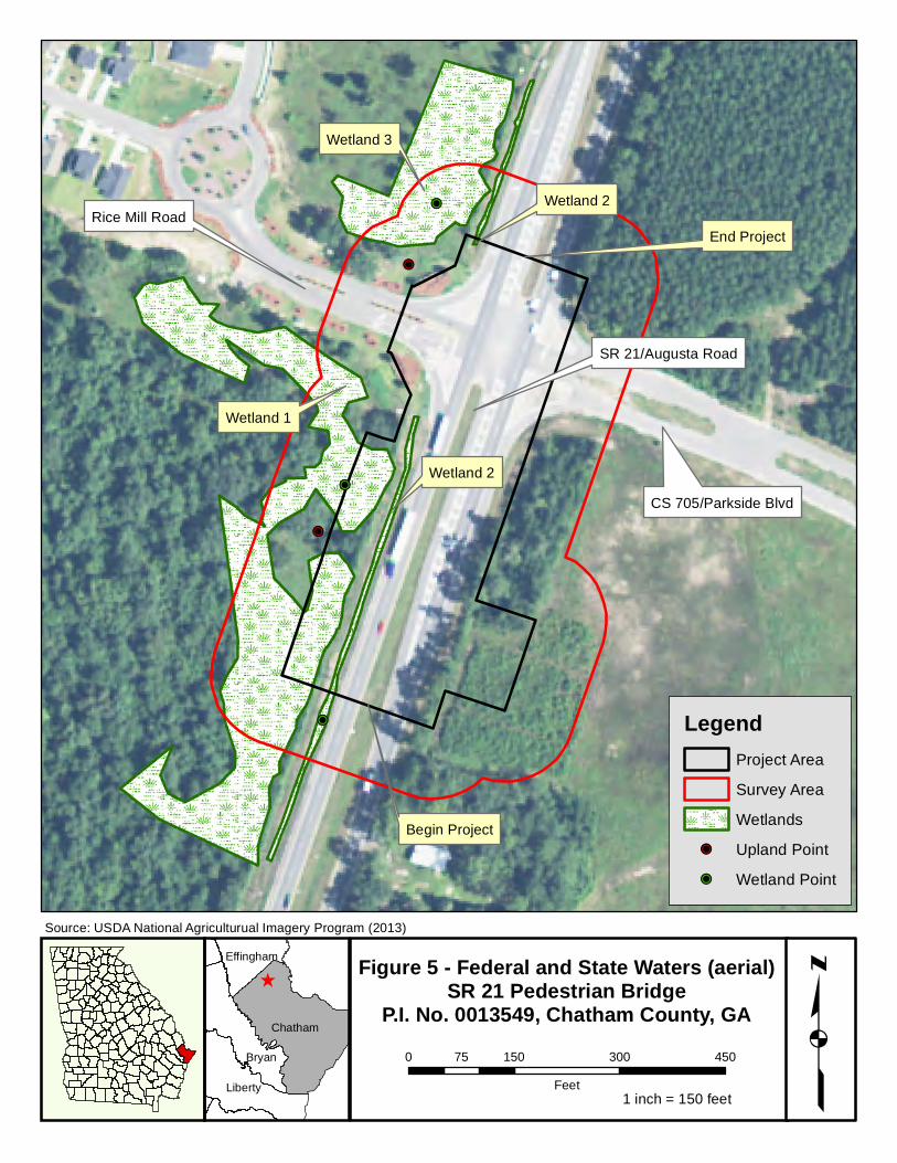
During the field surveys, three wetlands were identified as jurisdictional waters of the U.S. No perennial
or intermittent streams, ephemeral channels, or open waters were located within or adjacent to the
survey area. The proposed project would require a Section 404 Clean Water Act permit for impacts to
0.399 acre (0.386 acre permanent and 0.013 acre temporary) of wetland. It is anticipated that a Regional
Permit 01 would be applicable. A total of 2.4 wetland credits would be required for compensatory
mitigation.
State protected species potentially occurring within the survey area were determined through agency
coordination and online database searches. The GADNR reported a known occurrence of state protected
swallow-tailed kite (Elanoides forficatus, rare) within three miles of the project area. However, the
proposed project is located approximately 0.3 mile and 1.6 miles from large, high quality riverine wetland
corridors that provide higher quality foraging as well as nesting habitat for this migratory bird species.
Therefore, although potentially suitable foraging habitat for the swallow-tailed kite is located within the
survey area, construction of the proposed project would not be anticipated to impact this species. Thus,
the proposed project would result in “no take” to swallow-tailed kite.
Potential foraging and roosting habitat for bat species is present within forested habitats throughout the
survey area. During the 2016 field survey, no indication of bat presence was observed.
During the field surveys, no buffered or non-buffered state waters were identified. Therefore, a stream
buffer variance would not be required for the proposed project.
v Ecology Resource Survey and Assessment of Effects Report P.I. No. 0013549, Chatham County May 2016
TABLE OF CONTENTS
I. PROJECT OVERVIEW ................................................................................................................... 1
A. Project Location ............................................................................................................. 1 B. Need and Purpose ......................................................................................................... 1 C. Project Description ......................................................................................................... 1 D. Survey Methodology....................................................................................................... 1 E. Habitats and Land Use Areas .......................................................................................... 2
II. FEDERALLY PROTECTED RESOURCES ........................................................................................... 3
A. Protected Species and Habitats ....................................................................................... 3 i. Federally Threatened and Endangered ...................................................................... 4 ii. Federal Candidate Species ...................................................................................... 11 iii. Critical Habitat ....................................................................................................... 13 iv. Bald and Golden Eagles .......................................................................................... 13 v. Migratory Birds ...................................................................................................... 14 vi. Essential Fish Habitat ............................................................................................. 14
B. Invasive Species .......................................................................................................... 15 C. Waters of the U.S. ....................................................................................................... 15 D. Avoidance and Minimization of Federal Resource Impacts............................................... 17 E. Permit and Mitigation ................................................................................................... 18
III. STATE PROTECTED RESOURCES ................................................................................................ 18
A. State Threatened, Endangered, Rare and Unusual Species ............................................. 18 B. Bats ............................................................................................................................ 19 C. State Waters ............................................................................................................... 19 D. State Mandated Buffers ................................................................................................ 19 E. Avoidance and Minimization of State Resource Impacts .................................................. 20
IV. FIGURES ................................................................................................................................... 21
V. TABLES ..................................................................................................................................... 26
VI. PHOTOGRAPHS ......................................................................................................................... 32
Appendices
Appendix A - Field Data
Appendix B - Agency Coordination
Appendix C - Background Information
1 Ecology Resource Survey and Assessment of Effects Report P.I. No. 0013549, Chatham County May 2016
I. PROJECT OVERVIEW
A. Project Location
The purpose of this investigation was to document the site conditions and potential ecological impacts
associated with the proposed pedestrian bridge over State Route (SR) 21/Augusta Road (Rd) in Chatham
County, Georgia, approximately 5.3 miles northwest of Port Wentworth. The proposed project is located
within the Lower Savannah watershed (U.S. Geological Survey [USGS] Hydrologic Unit Code [HUC]
03060109). This watershed has not been designated as a priority watershed by the U.S. Environmental
Protection Agency (EPA). The proposed project is located in the Floodplains and Low Terraces (75i) Level
IV Ecoregion of Georgia. The approximate latitude and longitude of the midpoint of the proposed project
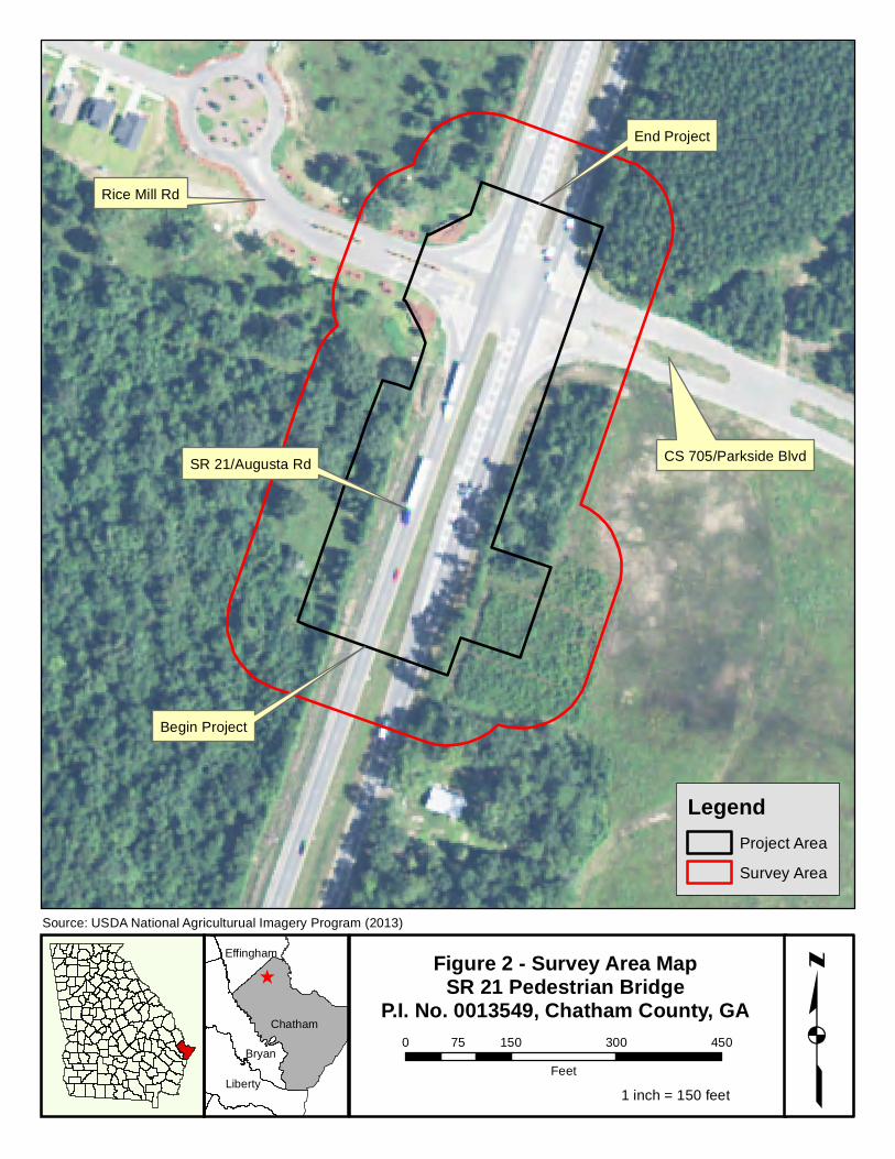
is 32.221134°, -81.198462° respectively (see Figure 1 – Project Vicinity Map and Figure 2 – Survey Area
Map).
B. Need and Purpose
The pedestrian crossing would serve the population of a growing subdivision located along Rice Mill Rd
and the newly constructed Rice Creek Elementary School. Residents would be able to use the crossing to
safely cross SR 21/Augusta Rd to take their children to school and access goods and services provided by
a new commercial development northeast of the SR 21/Augusta Rd and Rice Mill Rd intersection.
C. Project Description
The proposed project would consist of the design and construction of a pedestrian bridge over SR
21/Augusta Rd and a sidewalk to the nearest intersection of Rice Mill Rd and SR 21/Augusta Rd
approximately 300 feet north of the proposed pedestrian bridge. This project would be constructed using
a design-build process. A minor permanent easement would be required. The total length of the
proposed project is 0.13 mile.
D. Survey Methodology
Information used in the pre-field investigation of the survey area was derived from a number of sources.
These include USGS topographic 7.5’ quadrangle maps (Port Wentworth, GA), National Wetland
Inventory (NWI) maps, and U.S. Department of Agriculture (USDA) Soil Surveys for Chatham County.
Information concerning the occurrence of federally and state protected species within the project corridor
was gathered from the U.S. Fish and Wildlife Service (USFWS) Information for Planning and Conservation
(IPaC) website and the Georgia Department of National Resources (GADNR) Non-game Conservation
Section (NCS) rare elements database. On December 3, 2015, early coordination was initiated with the
GADNR NCS and USFWS requesting information regarding known or potential occurrences of protected
species within a three-mile radius of the proposed project. Response letters were received from the
GADNR NCS on January 11, 2016 and USFWS on December 7, 2015 (see Appendix B – Agency
Coordination). Mapped information, aerial photography, and on-site verification were used to perform
determinations for all jurisdictional waters of the U.S. Furthermore, jurisdictional wetland determinations
were performed using the three-parameter approach (hydrophytic vegetation, hydric soils, and
hydrology) as described in the 1987 U.S. Army Corps of Engineers (USACE) Wetland Delineation Manual
and utilized the 2010 Atlantic and Gulf Coastal Plain Regional Supplement as guidance.
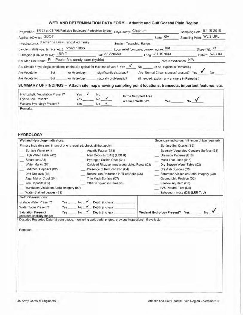
HNTB ecologists Katharine Bleau and Alexander Terry conducted a field investigation and general habitat
assessment along the proposed corridor on January 18, 2016. The field survey took approximately 8
hours to complete. An additional field survey was conducted on March 16, 2016 by HNTB ecologists
Katharine Bleau and Austin Meadows; this field survey took approximately 4 hours to complete. A
2 Ecology Resource Survey and Assessment of Effects Report P.I. No. 0013549, Chatham County May 2016
qualifications statement for the surveyors is included in Appendix C – Background Information. The field
survey was performed to determine natural resource conditions and to confirm available published
information concerning the survey area. Plant communities and their associated wildlife were then
assessed by pedestrian surveys. The survey area extended 100 feet from either side of the
environmental survey boundary developed during the conceptual design phase for this project and
encompassed approximately 8.84 acres (see Figure 2 – Survey Area Map).
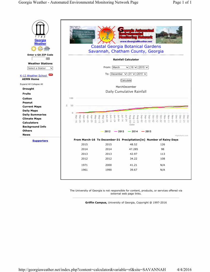
Precipitation archives were reviewed at the Georgia Automated Environmental Monitoring Network
website for Savannah, Georgia located at the Coastal Georgia Botanical Gardens, approximately 16.4
miles southwest of the project site. On January 16, 2016, two days prior to the first field survey, no rain
was recorded. Approximately 0.99 inch of rain was recorded on January 17, 2016, the day before the
field survey. No rain was recorded on the day of the field survey, January 18, 2016. The 30-year average
rainfall for the 30 days prior to the start of the first field survey (from December 18 to January 17) is 3.66
inches. The total rainfall recorded for this 30-day time period in 2015/2016 was 4.71 inches, which is
1.05 inches above the 30-year average for this weather station. The 30-year average annual rainfall is
49.74 inches. This weather station documented 57.43 inches from January 18, 2015 to January 17, 2016,
the year preceding the first field survey, which is 7.69 inches above the average. On March 14 and 15,
2016, the two days prior to the second field survey, 0.01 and 0.00 inch of rain were recorded,
respectively. No rain was recorded on the day of the survey, March 16, 2016. The 30-year average
rainfall for the 30 days prior to the start of the second field survey (from February 15 to March 15) is
2.94 inches. The total rainfall recorded for this 30-day time period in 2016 was 1.05 inches, which is 1.89
inches below the average. The 30-year average annual rainfall is 49.62 inches. This weather station
documented 56.27 inches from March 16, 2015 to March 15, 2016, the year preceding the second field
survey, which is 6.65 inches above the average. Refer to Appendix C – Background Information for all
weather and climatic data documents.
E. Habitats and Land Use Areas
The proposed project is located within a predominantly commercial/residential area of Chatham County.
The project is located in the Lower Coastal Plain physiographic province of Georgia and has low, flat
topography characterized by broad wetlands and low gradient streams. Four distinct habitat/land use
communities were observed in the survey area: commercial/institutional, maintained right-of-way (ROW),
mixed pine-hardwood forest, and ruderal (see Figure 3 – Habitat Map). A detailed description of these
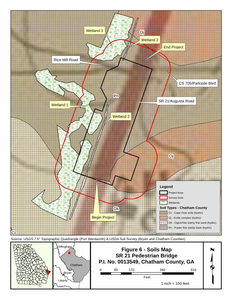
habitat/land use types is included below. The soils found in the survey area include: Ocilla complex (Oj);
Ogeechee loamy fine sand (Oj); and Pooler fine sandy loam (Pn) (see Figure 6 – Soil Map). Hydric soils
include all of the aforementioned soils.
Maintained ROW
This community comprises 4.52 acres (51.2 percent) of the survey area. This community is dominated by
grasses and ruderal plant species and is frequently maintained. Vegetative species include bluestem
May 2016 1 all resources occur within HUC 03060109
Table 2 Protected Species Summary
P.I No. 0013549, Chatham County
Species Common Name Federal Status
State Status
Habitat Present
Habitat Impacted Survey Season Survey
Date Individuals
Found Biological
Determination
Special Provision 107.23H
Acipenser oxyrinchus oxyrinchus3,4 Atlantic sturgeon E E No No April 30 –
Nov 30 N/A ND No Take No
Acipenser brevirostrum1,3,4 Shortnose sturgeon E E No No April 30 –
Nov 30 N/A ND No Take No
Eubalaena glacialis3,4 North Atlantic right whale E E No No Dec – March N/A ND No Take No
Trichechus manatus1,3,4 West Indian manatee E E No No March –
October N/A ND No Take No
Lepidochelys kempii3,4 Atlantic ridley sea turtle E E No No April –
October N/A ND No Take No
Lindera melissifolia3,4 Pondberry E E No No Late February – mid-March N/A ND No Take No
Picoides borealis3,4 Red-cockaded woodpecker E E No No April – May N/A ND No Take No
Dermochelys coriacea3,4 Leatherback sea turtle E E No No Fall; early
spring N/A ND No Take No
Mycteria americana2,3,4 Wood stork T E No No Early May N/A ND No Take No
Caretta caretta3,4 Loggerhead sea turtle T T No No Late spring –
early fall N/A ND No Take No
Chelonia mydas3,4 Green sea turtle T T No No May – Aug N/A ND No Take No
Ambystoma cingulatum1,2,3,4
Frosted flatwoods salamander T T No No Late fall –
winter N/A ND No Take No
E = Endangered; T = Threatened; C = Candidate; R = Rare; NL = Not Listed; N/A = Not Applicable; ND = Not Determined (no protected species survey performed)
1 GADNR coordination letter (dated January 11, 2016) 3 IPAC (Chatham Co.) (downloaded January 16, 2016) 2 USFWS coordination letter (dated December 7, 2015) 4 GADNR Rare Elements Location Data (Chatham Co.) (updated September 23, 2015)
1 May 2016
Table 2 Protected Species Summary
P.I No. 0013549, Chatham County
Species Common Name Federal Status
State Status
Habitat Present
Habitat Impacted Survey Season Survey
Date Individuals
Found Biological
Determination
Special Provision 107.23H
Charadrius melodus3,4 Piping plover T T No No Dec – mid-Feb N/A ND No Take No
Drymarchon couperi3 Eastern indigo snake
T T No No Late fall –
early spring N/A ND No Take No
Calidris canutus rufa3,4 Red knot T R No No Late Jan – early Feb
N/A ND No Take No
Notopthalmus peristriatus3 Striped newt C T No No
Late winter – spring
N/A ND No Take No
Gopherus polyphemus3,4 Gopher tortoise C T No No Year-round N/A ND No Take No
Elanoides forficatus1 Swallow-tailed kite NL R Yes No April – early May N/A ND No Take No
E = Endangered; T = Threatened; C = Candidate; R = Rare; NL = Not Listed; N/A = Not Applicable; ND = Not Determined (no protected species survey performed)
1 GADNR coordination letter (dated January 11, 2016) 3 IPAC (Chatham Co.) (downloaded January 16, 2016) 2 USFWS coordination letter (dated December 7, 2015) 4 GADNR Rare Elements Location Data (Chatham Co.) (updated September 23, 2015)
2 May 2016
Table 3. WETLANDS AND OPEN WATERS
MITIGATION WORKSHEETS
May 2016 Table 3
PI No. 0013549
Chatham County
05/23/16 Katharine Bleau
ADVERSE IMPACT FACTORS
Factor Options
Dominant Effect Fill 2.0
Dredge 1.8
Impound 1.6
Drain 1.4
Flood 1.2
Clear 1.0
Shade 0.5
Duration of Effects 7+ years 2.0
5-7 years 1.5
3-5 years 1.0
1-3 years 0.5
< 1 year 0.1
Existing Condition Class 1 2.0
Class 2 1.5
Class 3 1.0
Class 4 0.5
Class 5 0.1
Lost Kind Kind A 2.0
Kind B 1.5
Kind C 1.0
Kind D 0.5
Kind E 0.1
Preventability High 2.0
Moderate 1.0
Low 0.5
None 0
Rarity Ranking Rare 2.0
Uncommon 0.5
Common 0.1
† These factors are determined on a case-by-case basis.
REQUIRED MITIGATION CREDITS WORKSHEET
Factor Wetland 1
(Fill)
Wetland 1
(Clear)
Wetland 2
(Fill)
Wetland 2
(Clear)
Dominant Effect 2.0 1.0 2.0 1.0
Duration of Effect 2.0 2.0 2.0 0.1
Existing Condition 1.0 1.0 0.1 0.1
Lost Kind 1.5 1.5 0.1 0.1
Preventability 0.5 0.5 0.5 0.5
Rarity Ranking 0.1 0.1 0.1 0.1
Sum of r Factors R1 = 7.1 R2 = 6.1 R3 = 4.8 R4 = 1.9 R5 = R6 =
Total Required Credits for HUC 03060109 = (R AA) = 2.346
32 Ecology Resource Survey and Assessment of Effects Report P.I. No. 0013549, Chatham County May 2016
VI. PHOTOGRAPHS
PHOTOGRAPHIC LOG
Photograph 1. Wetland 1, facing north, west of SR 21/Augusta Rd. Photograph 2. Wetland 2, facing north, southwest of intersection of SR 21/Augusta Rd and Rice Mill Rd.
Photograph 3. Wetland 2, facing north, northwest of intersection of SR 21/Augusta Rd and Rice Mill Rd.
Photograph 4. Wetland 3, facing northwest, west of SR 21/Augusta Rd.
P.I. No. 0013549, Chatham County Photographs taken January 18, 2016 1
PHOTOGRAPHIC LOG
Photograph 5. Mixed pine-hardwood forest habitat. Photograph 6. Institutional land use area.
Photograph 7. Commercial land use area. Photograph 8. Mixed pine-hardwood forest.
P.I. No. 0013549, Chatham County Photographs taken January 18, 2016 2
Photograph 11. Intersection of SR 21/Augusta Rd with Rice Mill Rd and CS 705/Parkside Boulevard.
P.I. No. 0013549, Chatham County Photographs taken January 18, 2016 3
Ecology Resource Survey and Assessment of Effects Report P.I. No. 0013549, Chatham County May 2016
Appendix A Field Data
Chinese privet Ligustrum sinense Lour.
4494325
Reporter Information
Species Information
Verification and Review
Infestation Information
Location Information
Record ID
Reporter Katharine Bleau , HNTB
Observation Date January 18, 2016
Date Entered April 04, 2016
Source Type Web Report
Common Name Chinese privet
Scientific Name Ligustrum sinense Phenology Mature,Sapling/Immature
Voucher 0
Reviewed Not Verified
Gross Area 10 sq feet
Infested Area 2 sq feet
Percent Cover Trace
Infestation Status Positive
Habitat Edge: Upland/wetland
Locality Southwest of intersection of SR 21/Augusta Rd and Rice Mill Rd.
Location Chatham County, Georgia, United States
Coordinates 32.2206,-81.1969 National Ownership OTH
EDDMapS. 2016. Early Detection & Distribution Mapping System. The University of Georgia -Center for Invasive Species and Ecosystem Health. Available online athttp://www.eddmaps.org/distribution/point.cfm?id=4494325; last accessed April 4, 2016.
EDDMapS. 2016. Early Detection & Distribution Mapping System. The University of Georgia -Center for Invasive Species and Ecosystem Health. Available online athttp://www.eddmaps.org/distribution/point.cfm?id=4494325; last accessed April 4, 2016.
Scientific Name Lonicera japonica Phenology Mature,Sapling/Immature
Voucher 0
Reviewed Not Verified
Gross Area 8 sq feet
Infested Area 2 sq feet
Percent Cover Trace
Infestation Status Positive
Habitat Edge: Upland/wetland
Locality Located northwest of intersection of SR 21/Augusta Rd and Rice Mill Rd.
Location Chatham County, Georgia, United States
Coordinates 32.222,-81.1965 National Ownership OTH
EDDMapS. 2016. Early Detection & Distribution Mapping System. The University of Georgia -Center for Invasive Species and Ecosystem Health. Available online athttp://www.eddmaps.org/distribution/point.cfm?id=4494326; last accessed April 4, 2016.
EDDMapS. 2016. Early Detection & Distribution Mapping System. The University of Georgia -Center for Invasive Species and Ecosystem Health. Available online athttp://www.eddmaps.org/distribution/point.cfm?id=4494326; last accessed April 4, 2016.
Ecology Resource Survey and Assessment of Effects Report P.I. No. 0013549, Chatham County May 2016
Appendix B Agency Coordination
1
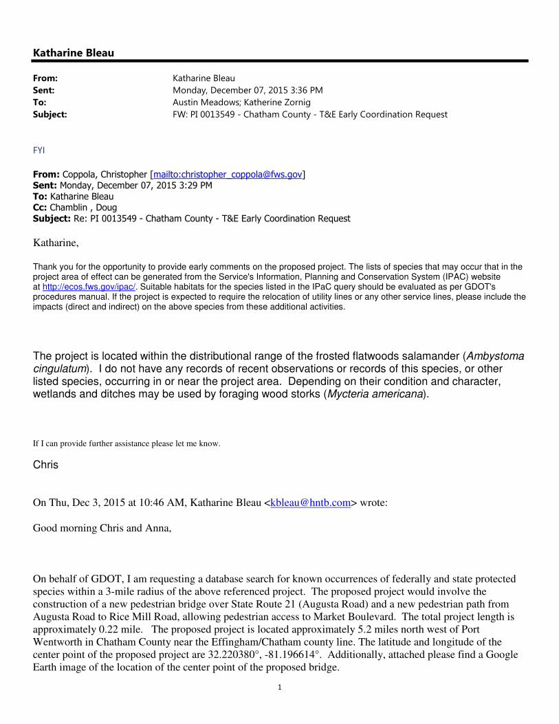
Katharine Bleau
From: Katharine Bleau
Sent: Monday, December 07, 2015 3:36 PM
To: Austin Meadows; Katherine Zornig
Subject: FW: PI 0013549 - Chatham County - T&E Early Coordination Request
FYI
From: Coppola, Christopher [mailto:[email protected]] Sent: Monday, December 07, 2015 3:29 PM
To: Katharine Bleau Cc: Chamblin , Doug
Subject: Re: PI 0013549 - Chatham County - T&E Early Coordination Request
Katharine,
Thank you for the opportunity to provide early comments on the proposed project. The lists of species that may occur that in the project area of effect can be generated from the Service's Information, Planning and Conservation System (IPAC) website at http://ecos.fws.gov/ipac/. Suitable habitats for the species listed in the IPaC query should be evaluated as per GDOT's procedures manual. If the project is expected to require the relocation of utility lines or any other service lines, please include the impacts (direct and indirect) on the above species from these additional activities.
The project is located within the distributional range of the frosted flatwoods salamander (Ambystoma cingulatum). I do not have any records of recent observations or records of this species, or other listed species, occurring in or near the project area. Depending on their condition and character, wetlands and ditches may be used by foraging wood storks (Mycteria americana).
If I can provide further assistance please let me know.
Chris
On Thu, Dec 3, 2015 at 10:46 AM, Katharine Bleau <[email protected]> wrote:
Good morning Chris and Anna,
On behalf of GDOT, I am requesting a database search for known occurrences of federally and state protected
species within a 3-mile radius of the above referenced project. The proposed project would involve the
construction of a new pedestrian bridge over State Route 21 (Augusta Road) and a new pedestrian path from
Augusta Road to Rice Mill Road, allowing pedestrian access to Market Boulevard. The total project length is
approximately 0.22 mile. The proposed project is located approximately 5.2 miles north west of Port
Wentworth in Chatham County near the Effingham/Chatham county line. The latitude and longitude of the
center point of the proposed project are 32.220380°, -81.196614°. Additionally, attached please find a Google
Earth image of the location of the center point of the proposed bridge.
2
I appreciate your help.
Thank you,
Katie
Katharine Bleau
Ecologist
HNTB Corporation
3715 Northside Parkway
200 Northcreek, Suite 800
Atlanta, GA 30327
Tel (404) 946-5761
Fax (404) 841-2820
www.hntb.com
This e-mail and any files transmitted with it are confidential and are intended solely for the use of the individual or entity to whom they are addressed. If you are NOT the intended recipient and receive this communication, please delete this message and any attachments. Thank you.
--
Christopher Coppola
Fish and Wildlife Biologist
Georgia Ecological Services
Townsend, Georgia 31331
MARK WILLIAMS DAN FORSTER COMMISSIONER DIRECTOR
NONGAME CONSERVATION SECTION 2065 U.S. HIGHWAY 278 S.E. | SOCIAL CIRCLE, GEORGIA 30025-4743
January 11, 2016 Katherine Bleau Ecologist HNTB Corporation 3715 Northside Parkway 200 Northcreek, Suite 800 Atlanta, GA 30327 Subject: Known occurrences of natural communities, plants and animals of highest priority conservation status on or near PI 0013549 Pedestrian Path and Bridge, Chatham County, Georgia Dear Ms. Bleau: This is in response to your request of December 3, 2015. According to our records, within a three-mile radius of the project site, there are the following Natural Heritage Database occurrences: (Site Center: -81.195796, 32.221354, WGS84) US Acipenser brevirostrum (Shortnose Sturgeon) approx. 2.3 mi E of site in the Lower
Savannah River US Acipenser brevirostrum (Shortnose Sturgeon) approx. 2.3 mi E of site in the Savannah
River Migration Corridor US Ambystoma cingulatum (Frosted Flatwoods Salamander) [HISTORIC] approx. 0.6 mi W
of site Coreopsis rosea (Rose Coreopsis) [HISTORIC] approx. 1.1 mi N of site GA Elanoides forficatus (Swallow-tailed Kite) approx. 2.1 mi NW of site Elliptio congaraea (Carolina Slabshell) approx. 2.5 mi NE of site in the Savannah River Hypericum erythreae (Georgia St. Johnswort) [HISTORIC] approx. 2.6 mi S of site Listera australis (Southern Twayblade) approx. 1.7 mi N of site Pseudacris brimleyi (Brimley's Chorus Frog) [HISTORIC] in an uncertain location near
the project site US Trichechus manatus (Manatee) approx. 2.2 mi E of site in tidal waters Vaccinium crassifolium (Evergreen Lowbush Blueberry) approx. 0.1 mi NW of site Nyssa biflora - (Nyssa aquatica, Taxodium distichum) Tidal Forest (Tidal Hardwood
Swamp Forest) approx. 1.4 mi S of site Quercus laurifolia / Carpinus caroliniana / Justicia ovata Forest (Diamondleaf Oak
Bottomland Forest) approx. 0.8 mi SW of site
IR 16108
Quercus phellos - Quercus (pagoda, similis) - Pinus taeda / Chasmanthium laxum Forest (South Atlantic Willow Oak Flatwoods Forest) approx. 1.2 mi SE of site
Savannah River Lower 1 (0306010906) [SWAP High Priority Watershed], on site Recommendations: We have no records of high priority species or habitats within the project area. However, two federally listed species, Acipenser brevirostrum (Shortnose Sturgeon) and Ambystoma
cingulatum (Frosted Flatwoods Salamander) have been documented within three miles of the proposed project. To minimize potential impacts to this or other federally listed species, we recommend consultation with the United States Fish and Wildlife Service. For southeast Georgia, please contact Strant Colwell (912) 832-8739 ext 1 or [email protected]). Surveys for species of conservation concern should be conducted prior to commencement of construction. We have the following recommendations for the applicant to consider. Please minimize disturbance to stream banks, wetlands, and riparian zones during bridge construction. Conduct activities from a stable stream bank or reinforced platform that does not cause degradation or destabilization of stream banks. Prohibit operation of equipment in the channel or use of the channel as a ford. We recommend that stringent erosion control practices be used during construction activities and that vegetation is re-established on disturbed areas as quickly as possible. Silt fences and other erosion control devices should be inspected and maintained until soil is stabilized by vegetation. Please use natural vegetation and grading techniques (e.g., vegetated swales, turn-offs, vegetated buffer strips) that will ensure that the road or ROW does not serve as a conduit for storm water or pollutants into the stream during or after construction. No uncured concrete or water used to facilitate curing should be discharged directly into the stream; curing water should be pumped into filter bags (i.e., "dirt bags") or detention basins before coffer dams or other diversion structures are dismantled. These measures will help protect water quality in the vicinity of the bridge crossings as well as downstream. Please be aware that the type of erosion control material that is used may have an impact on wildlife, particularly snakes. We recommend natural, biodegradable materials such as ‘jute’ or ‘coir’ be used. Mesh strands should be movable, as opposed to fixed. We do not recommend plastic fencing, as it frequently leads to snake entrapment and death. We are glad to see sidewalk construction, which will facilitate pedestrian use and reduce overall traffic. Please use best management practices during construction and there should be minimal impact on the surrounding environment. Disclaimer: Please keep in mind the limitations of our database. The data collected by the Nongame Conservation Section comes from a variety of sources, including museum and herbarium records, literature, and reports from individuals and organizations, as well as field surveys by our staff biologists. In most cases the information is not the result of a recent on-site survey by our
IR 16108
staff. Many areas of Georgia have never been surveyed thoroughly. Therefore, the Nongame Conservation Section can only occasionally provide definitive information on the presence or absence of rare species on a given site. Our files are updated constantly as new information is received. Thus, information provided by our program represents the existing data in our
files at the time of the request and should not be considered a final statement on the species
or area under consideration.
If you know of populations of highest priority species that are not in our database, please fill out the appropriate data collection form and send it to our office. Forms can be obtained through our web site (http://www.georgiawildlife.com/node/1376) or by contacting our office. If I can be of further assistance, please let me know. Sincerely,
Anna Yellin Environmental Review Coordinator
Data Available on the Nongame Conservation Section Website
Georgia protected plant and animal profiles are available on our website. These accounts cover basics like descriptions and life history, as well as threats, management recommendations and conservation status. Visit http://www.georgiawildlife.com/node/2721.
Rare species and natural community information can be viewed by Quarter Quad, County and HUC8
Watershed. To access this information, please visit our GA Rare Species and Natural Community Information page at: http://www.georgiawildlife.com/conservation/species-of-concern?cat=conservation.
Downloadable files of rare species and natural community data by quarter quad and county are also
available. They can be downloaded from: http://www.georgiawildlife.com/node/1370.
FISH AND WILDLIFE SERVICEGeorgia Ecological Services Field Office
105 WESTPARK DRIVE, WESTPARK CENTER SUITE DATHENS, GA 30606
PHONE: (706)613-9493 FAX: (706)613-6059
Consultation Code: 04EG1000-2016-SLI-0520 January 16, 2016Event Code: 04EG1000-2016-E-00412Project Name: SR 21 Pedestrian Bridge
Subject: List of threatened and endangered species that may occur in your proposed projectlocation, and/or may be affected by your proposed project
To Whom It May Concern:
This list identifies threatened, endangered, proposed and candidate species, as well as criticalhabitat, that may be affected by your proposed project. This list my change before your projectis completd. Under 50 CFR 402.12(e) of the regulations implementing section 7 of the Act, theaccuracy of this list should be verified after 90 days. The Service recommends that verificationbe completed by visiting the ECOS-IPaC website at regular intervals during project planningand implementation.
Bald and golden eagles are protected under the Bald and Golden Eagle Protection Act (16U.S.C. 668 ). Projects affecting these species may require development of an eagleet seq.conservation plan (http://www.fws.gov/windenergy/eagle_guidance.html).
Wind energy projects should follow the wind energy guidelineshttp://www.fws.gov/windenergy/ for minimizing impacts to migratory birds and bats.
Guidance for minimizing impactsof communcation towers on migratory birds can be foundunder the "Bird Hazards" tab at: .www.fws.gov/migratorybirds
Attachment
http://ecos.fws.gov/ipac, 01/16/2016 12:32 PM 1
Official Species List
Provided by: Georgia Ecological Services Field Office
105 WESTPARK DRIVE
WESTPARK CENTER SUITE D
ATHENS, GA 30606
(706) 613-9493 Consultation Code: 04EG1000-2016-SLI-0520Event Code: 04EG1000-2016-E-00412 Project Type: TRANSPORTATION Project Name: SR 21 Pedestrian BridgeProject Description: The proposed project would involve the construction of a new pedestrianbridge over State Route 21 (Augusta Road) and a new pedestrian path from Augusta Road to RiceMill Road, allowing pedestrian access to Market Boulevard. The total project length isapproximately 0.22 mile. Please Note: The FWS office may have modified the Project Name and/or Project Description, so itmay be different from what was submitted in your previous request. If the Consultation Codematches, the FWS considers this to be the same project. Contact the office in the 'Provided by'section of your previous Official Species list if you have any questions or concerns.
United States Department of InteriorFish and Wildlife Service
Project name: SR 21 Pedestrian Bridge
http://ecos.fws.gov/ipac, 01/16/2016 12:32 PM 2
Project Location Map:
Project Coordinates: The coordinates are too numerous to display here. Project Counties: Chatham, GA
United States Department of InteriorFish and Wildlife Service
Project name: SR 21 Pedestrian Bridge
http://ecos.fws.gov/ipac, 01/16/2016 12:32 PM 3
Endangered Species Act Species List
There are a total of 18 threatened, endangered, or candidate species on your species list. Species on this list should be
considered in an effects analysis for your project and could include species that exist in another geographic area. For
example, certain fish may appear on the species list because a project could affect downstream species. Critical habitats
listed under the Has Critical Habitat column may or may not lie within your project area. See the Critical habitats
within your project area section further below for critical habitat that lies within your project. Please contact the
designated FWS office if you have questions.
Amphibians Status Has Critical Habitat Condition(s)
frosted flatwoods salamander
(Ambystoma cingulatum)
Population: Entire
Threatened Final designated
Striped newt (Notophthalmus
perstriatus)
Candidate
Birds
Piping Plover (Charadrius melodus)
Population: except Great Lakes watershed
Threatened Final designated
Piping Plover (Charadrius melodus)
Population: Great Lakes watershed
Endangered
Red Knot (Calidris canutus rufa) Threatened
Red-Cockaded woodpecker (Picoides
borealis)
Population: Entire
Endangered
Wood stork (Mycteria americana)
Population: AL, FL, GA, MS, NC, SC
Threatened
Fishes
United States Department of InteriorFish and Wildlife Service
Project name: SR 21 Pedestrian Bridge
http://ecos.fws.gov/ipac, 01/16/2016 12:32 PM 4
Atlantic sturgeon (Acipenser
oxyrinchus oxyrinchus)
Population: South Atlantic DPS
Endangered
Shortnose sturgeon (Acipenser
brevirostrum)
Population: Entire
Endangered
Flowering Plants
pondberry (Lindera melissifolia) Endangered
Mammals
North Atlantic right Whale
(Eubalaena glacialis)
Population: Entire
Endangered Final designated
West Indian Manatee (Trichechus
manatus)
Population: Entire
Endangered Final designated
Reptiles
Eastern Indigo snake (Drymarchon
corais couperi)
Population: Entire
Threatened
Gopher tortoise (Gopherus
polyphemus)
Population: eastern
Candidate
Green sea turtle (Chelonia mydas)
Population: Except where endangered
Threatened Final designated
Kemp's Ridley sea turtle
(Lepidochelys kempii)
Population: Entire
Endangered
Leatherback sea turtle (Dermochelys Endangered Final designated
United States Department of InteriorFish and Wildlife Service
Project name: SR 21 Pedestrian Bridge
http://ecos.fws.gov/ipac, 01/16/2016 12:32 PM 5
coriacea)
Population: Entire
Loggerhead sea turtle (Caretta
caretta)
Population: Northwest Atlantic Ocean DPS
Threatened Proposed, Final
designated
United States Department of InteriorFish and Wildlife Service
Project name: SR 21 Pedestrian Bridge
http://ecos.fws.gov/ipac, 01/16/2016 12:32 PM 6
Critical habitats that lie within your project area
The following critical habitats lie fully or partially within your project area.
Birds Critical Habitat Type
Piping Plover (Charadrius melodus)
Population: except Great Lakes watershed
Final designated
Reptiles
Loggerhead sea turtle (Caretta caretta)
Population: Northwest Atlantic Ocean DPS
Final designated, Proposed
United States Department of InteriorFish and Wildlife Service
Project name: SR 21 Pedestrian Bridge
COUNTY TYPE SCIENTIFIC NAME COMMON NAME
FEDERAL
STATUS
STATE
STATUS HABITAT REQUIREMENTS
Chatham Animal Acipenser brevirostrum Shortnose Sturgeon LE E
Estuaries; lower end of large rivers in deep pools with soft
substrates
Chatham Animal Acipenser oxyrinchus oxyrinchus Atlantic Sturgeon LE E Large rivers and estuaries on Atlantic Coast
Chatham Animal Ambystoma cingulatum Frosted Flatwoods Salamander LT T Pine flatwoods; moist savannas; isolated cypress/gum ponds
Chatham Plant Amorpha georgiana Georgia Indigo Bush E Longleaf pine flatwoods; stream terraces
Chatham Animal Calidris canutus Red Knot C R Beaches and exposed mudflats
Chatham Animal Caretta caretta Loggerhead Sea Turtle LT E Open ocean; sounds; coastal rivers; beaches
Chatham Community
Carya glabra - (Quercus hemisphaerica) /
Serenoa repens / Chasmanthium sessiliflorum
Forest Dry Hickory Maritime Forest Georgia habitat information not available
Ecology Resource Survey and Assessment of Effects Report P.I. No. 0013549, Chatham County May 2016
Appendix C Background Information
Qualifications Statement
Surveyors:
Katharine Bleau Ecologist Ecology, B.S.; Biology, B.S. 3 years of ecology field experience with GDOT projects Austin Meadows Ecologist B.S.F.R. Fisheries and Aquaculture 11 years of ecology field experience with GDOT projects Alexander Terry Ecologist Ecology, B.S. 10 months of ecology field experience with GDOT project
Coastal Georgia Botanical Gardens Savannah, Chatham County, Georgia
Rainfall Calculator
From: January 1 2016
To: March 15 2016
Calculate
JanuaryMarch
From January-1 To March-15 Precipitation[in] Number of Rainy Days
2016 2016 7.75 19
2015 2015 8.37 24
2014 2014 6.24 27
2013 2013 11.99 23
1971 2000 8.41 N/A
1961 1990 8.84 N/A
GeorgiaWeather
Enter a GA ZIP Code
GO
Weather Stations
Select a Station
K-12 Weather School
AEMN Home
Expand All Collapse All
Drought
Fruits
Cotton
Peanut
Current Maps
Daily Maps
Daily Summaries
Climate Maps
Calculators
Background Info
Others
News
Supporters
The University of Georgia is not responsible for content, products, or services offered via
external web page links.
Griffin Campus, University of Georgia, Copyright @ 1997-2016