32
Land Judging and Homesite Evaluation Guidebook Kansas State University Agricultural Experiment Station and Cooperative Extension Service

Land Judging and Homesite Evaluation
Guidebook
Kansas State University Agricultural Experiment Station and Cooperative Extension Service


1
INTRODUCTIONThe study of land and its wise use should be important
to everyone. Soils have a wide variety of uses, but not all soils are equally adapted to each use. Some soils are suitable for several purposes and are in high demand. For example, highly productive agricultural land often provides the easiest and cheapest sites for building homes. Other soils have properties that make them well suited for some uses, but poorly suited for others. Gravelly soil might be an excellent source of fill material for a road, but the same soil would be unsuitable for building a sewage lagoon. An evaluation of soil properties is essential for making intelligent decisions about land use and management.
It takes tens of thousands of years for a soil to form. Yet, with unwise management, it could be destroyed within a couple of generations. Therefore, it is important that we understand our soils and know how to manage them wisely. This manual is a first step in helping you understand the important factors in soil management. Land judging and homesite evaluation is a popular 4-H and FFA judging event. In judging land, it is necessary to learn a few things about soils. This manual will assist you in learning more about such things as texture, structure, horizons, depth, permeability, erosion, slope, and capability classes. In home-site evaluation, many of the same soil features are evaluated with regard to foundations for buildings, septic systems, sewage lagoons, lawns, and landscaping.
Land judging and homesite evaluation will help you:• Understand basic soil differences.• Know how soil properties affect crop growth.• Recognize the influence of land features on production
and land protection.• Select suitable soil and water conservation practices.• Determine land capability class.• Recommend proper land use and treatment.• Evaluate for nonagricultural uses.
Land is a natural resource economically usable to meet many of our needs. It provides many raw materials and enables us to produce food and fiber for clothes and shelter, and to collect and store water for future use. It also provides a place to stand, room for cities, highways, recreation, and many other things requiring space. The quantity is limited and quality varies from place to place. Thus, we must constantly reconsider decisions on using and managing land as population increases and technology changes.
Land resources are really soil resources under our influ-ence. How we use and manage soils reflects our knowledge, or lack of it, about soils and soil-related factors at any given time.

2
CHAPTER 1: LAND JUDGING
PART 1: Soil FactorsIn Part 1 of this chapter we will discuss which factors
are important in the classification of a soil. The soil factors include texture, depth, slope, and erosion. We will also discuss interpretations of the soil factors such as perme-ability, structure, and surface runoff.
Soils form when climate and organisms act on geologic materials. Topography and time are important factors in this process. Because the soil-forming processes work from the top of the soil down, we usually find the most developed part of a soil on top and the least developed part deepest in the soil. This layering is called a soil profile, and the layers are called horizons (Figure 1). The soil-forming factors vary widely over Kansas, producing many kinds of soils with different profile features and other properties. Soils vary in the kind, number, and degree of development of major horizons, and many subhorizons that may form. Few soils have all the major and minor horizons, but all soils exhibit some of them. Therefore, we may define soil as mineral matter on the surface of the earth that was changed over
time as a result of climate, organisms (plants and animals), and topography. Soils are given names in the system of soil classification.
TextureTexture is the proportional amount of sand, silt, and
clay in a soil. Each horizon may have a texture different from any other. Texture, in combination with soil structure, affects moisture-holding capacity, permeability, capacity to hold and furnish nutrients, tillage operations, bearing capacity, and erosion. Only the textures of surface and subsoil layers are determined in the contest. Texture of the underlying material is also important, especially for trees, deep-rooted crops, septic tank disposal fields, and building foundations.
Sand, silt, and clay are soil particles that are defined on the basis of their size (Figure 2). Sand grains are 2 to 0.05 mm in diameter, large enough to be seen and to impart a gritty feeling to the soil. Silt particles are 0.05 to 0.002 mm in diameter, and produce a smooth, floury feel. Clay particles are less than 0.002 mm in diameter and usually flat. Clay particles are small enough to make the soil sticky when wet or hard when dry (Figure 2). Individual silt and clay particles are too small to be seen by the eye.
O
R
C
B
A
Organic horizon of undecomposed (01) and decomposed (02) organic matter. Absent in cultivated and many other soils.
Mineral surface soil which has accumulated decomposed organic matter and is usually darker colored than lower layers. It is also the horizon that has lost organic matter, clay, iron and aluminum due to downward movement.
Mineral horizon that usually has a �ner texture, or a darker, stronger, redder color and a distinctly di�erent developed structure. Structure is often more distinct than in the A horizon.
Mineral horizon of weathered parent material like the material from which the soil developed or other substratum of unconsolidated material not related to the above soil.
Underlying consolidated bedrock. Absent under many soils.
Horizons
Figure 1. Hypothetical soil profile showing the letter designation used in describing the major kinds of horizons usually present.
A soil profile containing A, B, C, and R horizons. The photo scale is in meters, so bedrock is present in this soil profile 1.2 meters, which is 47 inches.

3
The terms sand, silt, clay, and loam are used in various combinations to name 12 textural classes. For example, one of the classes is loamy sand and another is silty clay. A simpler classification containing five textural groups will be used in the land-judging contest. These five groups are called coarse, moderately coarse, medium, moderately fine, and fine. These groups contain one or more of the textural classes shown in Figure 3.
Soil texture can be determined by a laboratory proce-dure or in the field. The field method requires feeling the soil with the fingers. First, determine the ribbon length, and then determine the level of grittiness. Figure 4 provides a helpful instructional diagram for determining texture by feel. This skill can be developed and perfected with practice. Contestants should practice with samples of known texture. For contest purposes, a boxed sample of surface soil and a sample of subsoil will be provided to judge texture.
A brief description of each of the five textural groups follows:Coarse-textured soils are loose, friable, and individual grains
can be readily seen or felt. When squeezed between thumb and forefinger, the soil feels gritty. If squeezed when dry it will fall apart as pressure is released. Using moist soil, it is possible to form a mold that is unstable and crumbles as the soil is handled.
Moderately coarse-textured soils are gritty but contain enough silt and clay to make moist soil hold together. The individual sand grains can readily be seen and felt. If squeezed when dry, it will form a mold that breaks readily when handled. If squeezed when moist, it will form a mold that can be carefully handled without breaking.
Medium-textured soils have a slightly gritty, smooth, or velvety feel when moist. If squeezed when dry, the soil forms a mold that will bear careful handling. The mold formed by squeezing when moist can be handled freely, without breaking. When the moistened soil is squeezed out between thumb and forefinger it makes only a weak ribbon.
Moderately f ine-textured soils usually break into clods or lumps when dry. When the moist soil is squeezed out between thumb and forefinger, it will form a short ribbon that will tend to break or bend downward. Note that the soil also may have a slightly gritty or velvety feel when moist, but it is the presence of a 1 to 2 inch ribbon that places the soil into this category.
Fine-textured soils form hard lumps or clods when dry and are quite plastic and sticky when wet. When the moist soil is squeezed out between thumb and forefinger, it will form a long ribbon that will support itself. Note that the soil also may have a slightly gritty or velvety feel when moist, but it is the presence of a ribbon longer than 2 inches that places the soil into this category.
Sand0.002 to 0.08 inch(0.05 to 2 mm)feels gritty
Silt(0.00008 to 0.002 inch0.002 to 0.05 mm) feels smooth
Clayless than 0.00008 inch(0.002 mm) feels sticky
Figure 2. General characteristics of sand, silt and clay. (Adapted from Oregon State University Extension Service.)
Textural Group Textural ClassCoarse Sand, loamy sandModerately coarse Sandy loamMedium Loam, silt loam, siltModerately fine Sandy clay loam, clay loam,
silty clay loamFine Sandy clay, clay, silty clay
CLAY
SILTY CLAY
SANDY CLAY
SANDY CLAYLOAM
SANDY LOAM
LOAM
CLAY LOAMSILTY CLAY
LOAM
SILT LOAM
SAND
LOAMYSAND
PERCEN
T CLA
Y PERCENT SILT
PERCENT SAND100 90 80 70 60 50 40 30 20 10 0
100
90
80
70
60
50
40
30
20
10
0
100
90
80
70
60
50
40
30
20
10
0
SILT
Figure 3. The standard USDA textural triangle for determining the 12 textural classes and five textural groups.

4
DepthThe total thickness of material available for plant root
growth is important. Plants obtain water, nutrients, and mechanical support from the root zone. The thickness of soil above a layer that stops root development is consid-ered the soil depth. This depth includes the surface and subsoil plus any parent material that is favorable for root development. Parent material is the sediment or material from which the soil profile is formed. Examples include wind-deposited sediments, sediments deposited by water or glaciers, or weathered bedrock. Layers that may stop root development include bedrock, clay or shale beds, water table, or unaltered alluvial material. The depth classes for the contest are:
Deep — more than 40 inches of usable soil.Moderately deep — 20 to 40 inches of usable soil.Shallow — 10 to 20 inches of usable soil.Vey shallow — less than 10 inches of usable soil.
SlopeSlope refers to the steepness of the land surface. Slope
is important because it affects soil use and management. It is directly related to the water erosion hazard, and it influ-ences a farmer’s choice of crops and conservation practices. Irrigation becomes more difficult on steeper slopes and so does the operation of farm machinery. In general, as slope increases, agricultural suitability decreases.
Start
Coarse Texture
Piace approximately 1 oz (28 g) soil in palm. Add water dropwise and knead soil to break down all aggregates. Soil is at the proper consistency when plastic and moldable, like moist putty.
Does soild remain in a ball when squeezed?
No NoIs soil too dry?
Yes
Add dry soil to soak up water.
Yes
Is soil too wet?
No Coarse Texture
Yes
Place ball of soil between thumb and fore�nger, gently pushing the soil with the thumb, squeezing it upward into a ribbon. Form a ribbon to emerge and extend over the fore�nger, breaking from its own weight.
No
Yes
Does soil form a ribbon?
Does soil make a weak ribbon less than 1 inch (2.54 cm) long before breaking?
NoDoes soil make a medium ribbon 1-2 inches (2-5 cm) long before breaking?
Does soil make a strong ribbon 2 inches (5 cm) or longer before breaking?
No
Yes
Excessively wet a small pinch of soil in palm and rub with fore�nger.
Moderately CoarseTexture
No
Does soil feel very gritty?
MediumTexture
Yes
Moderately FineTexture
FineTexture
Yes
Figure 4. Instructional diagram for determining texture by feel. Adapted from S.J. Thien ( J. of Agronomic Education, 1979, Vol.8, pp. 54-55.

5
Slope is measured in percent. It refers to the number of feet of rise or fall in 100 feet of horizontal distance (Figure 5). Five feet of fall in 100 feet of horizontal distance would be a 5 percent slope.
Slope classes for the contest are:Nearly level — less than 1 foot fall or rise in each 100 feet.Gently sloping — 1 to 3 feet fall or rise in each 100 feet.Moderately sloping — 3 to 5 feet fall or rise in each 100 feet.Strongly sloping — 5 to 8 feet fall or rise in each 100 feet.Steep — 8 to 15 feet fall or rise in each 100 feet.Very steep — above 15 feet fall or rise in each 100 feet.
ErosionErosion is the process that causes loss of soil by the
action of water and wind. Both water and wind erosion can be serious problems in Kansas.
Water erosion can be broken down into sheet, rill, and gully erosion. Sheet erosion results mainly from the splash of raindrops. Runoff water removes a fairly uniform layer from the soil surface. Rill erosion is found in fields where runoff water concentrates and cuts small channels called rills in the soil. These rills are apparent after a heavy rain but usually are smoothed over by the next tillage operation. Gully erosion is probably the most noticeable and is caused by water concen-trating in a natural water course and cutting deeper and deeper into the soil.
The term “gullies” includes both crossable and uncross-able, unless otherwise specified. A crossable gully is one that can be crossed with normal farm machinery. Frequent gullies are less than 100 feet apart. Occasional gullies are more than 100 feet apart.
Gullies should be at least 6 inches deep and 12 inches wide. Field irregularities that are covered with grass, with no signs of erosion, are not considered gullies.
Wind erosion is a result of strong, turbulent winds blowing across an unprotected surface that is smooth, loose, dry, and finely granulated. Soil transport by wind is commonly divided into three processes: suspension, salta-tion, and creep. Suspension occurs when minute particles are suspended in the air stream and carried for long distances. This is the most visible type of wind erosion (“dust cloud“). Usually less than 10 percent of wind transport is the result of suspension. Slightly larger particles often bounce or jump near the soil surface. This process is called saltation and
often accounts for 50 to 80 percent of total wind transport. When saltating particles bounce off the ground, they often knock loose other soil particles, thus continuing the erosion process. Coarse, sand-sized particles, too large to leave the surface, can roll along the soil surface. This process is known as surface creep and constitutes 7 to 25 percent of wind transport.
Erosion is a selective process that removes the finer, more fertile soil materials. As erosion continues, more and more surface soil is removed, decreasing the depth to subsoil. Subsoils almost always have less organic matter and contain more clay than surface soils. Therefore, erosion reduces the favorable soil properties attributed to organic matter, such as better water and nutrient holding capacity and faster water absorption. The amount of surface soil remaining largely determines the effect of erosion on crop yields. Wind erosion causes plant damage from abrasion, exposure of roots by removing topsoil, or burial by drifts of wind blown soil, which is called a “blowout.”
Soil erosion can be controlled by a number of different methods. Conservation tillage or the practice of leaving crop residues on the soil surface is becoming a popular practice. Types of conservation tillage include no-till, strip-till, mulch-till, and ridge-till. Other methods for controlling water erosion are terracing, contour tillage, grass waterways, buffer strips, and vegetative cover. Wind erosion control methods are field windbreaks, vegetative cover, filter strips, and emergency tillage.
For contest purposes, erosion level is determined by comparing the original topsoil thickness shown on the
100 feet
5 feet
Figure 5. Illustration of a 5 percent slope.
A newly formed uncrossable gully in a crop f ield.

6
“condition of field” card to the present depth of surface soil. The erosion levels used in the contest are:None to slight — less than 25 percent of the surface soil
removed and no gullies.Moderate — 25 to 75 percent of the surface soil removed.
Small rills and occasional, crossable gullies may be present. Moderate erosion may or may not change a capability class, but it always is a factor to keep an area out of Class I.
Severe —more than 75 percent of the original surface layer is removed. The plow layer exhibits characteristics predominately of “B” horizon. Frequent crossable gullies, or occasional uncrossable gullies, or occasional wind blow-out areas may be present.
Very severe — more than 75 percent or more of the surface soil removed. Frequent uncrossable gullies and blow-outs exist.
Interpretation of Soil Factors
StructureSoil structure is not judged; however, it is important in
its effect on permeability and land use. Soil structure forms when individual grains of sand, silt, and clay are bound together in larger units called peds. Plant roots, soil organic matter, and clay particles all provide physical and chemical binding agents.
Soil structure is important because it modifies some of the undesirable effects of texture on soil behavior. Structure creates relatively large pores, which favor water entry in and through the soil. Good soil structure means good aeration and a favorable balance between pores that contain air and pores that store water. Soils with good structure are easy to work and provide an ideal environment for plant root growth.
The shape and arrangement of soil particles into clus-ters or aggregates determine the type of structure.
Granular structure is composed of spherical particles, 1 to 10 mm in diameter. The structure is most common in the surface soil, where plant roots, microorganisms, and sticky products of organic matter decomposition bind soil grains into granular aggregates.
Platy structure can occur in a tillage pan or at the bottom of the tillage layer. Platy structure is made of flat peds that lie horizontally in the soil. Most platy structures are less than ¾ inch thick.
Blocky structures are roughly cube shaped, with more or less flat surfaces. There are two types of blocky structure, angular blocky and subangular blocky. Angular blocky struc-tures have sharp edges and corners. The edges of subangular blocky structures are rounded. Blocky structures range from ¼ inch to 2 inches across. Blocky structures are typical of B horizons.
Prismatic structures are larger, vertically elongated blocks. Sizes are commonly 3⁄8 inch to 4 inches across,
Massive structures are compact, coherent soil not sepa-rated into peds. Massive structures can be found in clayey, very slowly permeable soils.
Single grain structure occurs in some sandy soils where every grain acts independently and there is no binding agent to hold the particles together.
You can observe the structural type by carefully observing the soil and gently breaking it apart. It is best to observe soil structure in the soil profile rather than in the sample box because of disturbance. The first step is to fill your hand with a large lump of soil. Next, gently apply pressure to break the soil apart. The shapes of the peds you broke out of the soil indicate the structural type.
PermeabilityPermeability refers to the movement of air and water
through the soil. Permeability is affected by all soil char-acteristics. It is extremely important because it affects the supply of air, moisture, and soil nutrients in the root zone.
Each soil layer has a permeability rating, but the soil’s permeability is determined by the relative rate of moisture and air movement through the most restricting layer within the upper 40 inches of the effective root zone. For contests, the permeability of the subsoil should be judged from the soil profile. Subsoil texture and structure are of primary importance in determining permeability.
Permeability classes are:Rapid — Soils with coarse-textured subsoils that are gran-
ular or single-grained have rapid permeability. Subsoils tend to be friable or loose when moist, and exhibit little restriction of water or air.
A contestant uses a knife to determine topsoil depth.

7
Moderate — Soils with moderately fine-textured subsoils that are prismatic, subangular blocky, or angular blocky have moderate permeability. Also most medium-textured and moderately coarse-textured subsoils have moderate permeability regardless of structure. These subsoils tend to be friable to very friable with large visible pores.
Slow — Soils that have moderately fine-textured subsoils with well-developed angular blocky and subangular blocky structures have slow permeability. These subsoils tend to be firm when moist. Soil units tend to break more easily along the vertical axis than in the very slow permeable soils. Soils with slow permeability frequently have deep surface and thick transitional horizons from the surface to the most clayey horizon in the profile.
Very slow — Soils that have dense, fine-textured subsoils and claypan soils are very slowly permeable. The structure is massive or weakly developed subangular blocky or angular blocky. It has few visible pores. These subsoils tend to be firm when moist. Root growth generally is restricted to ped faces and cracks.
Surface RunoffSurface runoff refers to the relative rate water is
removed by flowing over the surface of the soil. Surface runoff is a result of the combination of slope, infiltration, landscape position, and permeability. The surface runoff classes used in the contest include:Rapid — surface water flows rapidly. A considerable
amount of rainfall is lost from the surface, increasing hazards of erosion and droughty conditions. Fields with slopes greater than 3 percent (except soils with rapid permeability) would be in this category.
Moderate — water drains away readily, yet slowly enough that a large amount of the water enters the soil. This condition causes little erosion hazard and is considered to cause a normal amount of runoff. This class occurs on soils with slopes of 1 to 3 percent (except for soils with rapid permeability).
Slow —Water flows away so slowly that free water covers the soil for moderate periods. This increases the moisture supply but may interfere with farming opera-tion. This condition occurs on slopes of 0 to 1 percent and includes soils with moderate, slow, or very slowly permeable subsoils.
Very slow — water runs off so slowly or stands so long that the soil remains wet for long periods. Generally this condition occurs on nearly level concave landscapes. However, deep sandy soils with rapidly permeable subsoils on slopes also have very slow runoff because the infiltration is so high that rainfall produces little or no runoff.
Land Capability ClassificationLand capability classes were developed by the USDA
Natural Resources Conservation Service and are widely used in the preparation of conservation plans. Land capability classification helps identify limitations and hazards of using land for agricultural purposes. Land capability classification can be used to determine whether an area of land is best suited for crops, pasture, or woodland. There are eight land capability classes based on the degree of hazard or limitation for use of the land. Class I is the best land, while Class VIII has the most limitations. Classes I through IV are suited for almost any use, including cropland, with varying degrees of hazards or limitations if used as cropland. Class I has the broadest potential and Class IV the most restricted use as cropland. A similar pattern applies to pasture or wood-land use for Classes V through VII. Class VIII land is so restricted that its use is limited to recreation or wildlife.
CroplandClass I land is suitable for nearly any use because it has no
special hazards or limitations. These soils are produc-tive and easy to work. Good management is sufficient without any special conservation practices. Class I soils have few limitations that restrict their use for intensive crop production. For contest purposes, overhead water, water that will run on to the site from adjacent, upslope land, will not lower the land capability class on Class I soils.
Class II is good land that can be adapted for nearly any use by taking some precautions to meet its needs. Some Class II land will need erosion control practices such as terraces or conservation tillage. Several other hazards or limitations, such as moderate wetness, may cause land to be placed in Class II if not too severe. In general, Class II land has nearly the same potential as Class I land except that special needs must be met. Class II land has some limitations that restrict use for intensive crop production.
Class III land is good land, but it needs more intensive treat-ment than Class II land. Slope, permeability, depth, and texture are all factors, which can be limiting on Class III land. Normal crops can be grown on Class III land, but special treatment or management practices must be provided to control erosion. Soils in Class III have severe limitations that reduce the choice of plants or require special conservation practices, or both.
Class IV can be used occasionally for cropland under careful management but is better adapted for hay or pasture most of the time. Some land is in Class IV because it already has been severely eroded by previous misuse. Soils in Class IV have severe limitations that restrict the choice of plants, require careful management, or both.

8
NoncroplandClass V land is not suited for cropland but is not likely to be
damaged by woodland or pasture use. Soils in Class V have little or no surface erosion hazard. Class V land is limited by some permanent obstruction such as rock outcrops, a meandering stream channel, wetness, poor drainage, or frequently flooded areas. (For contest purposes, frequently flooded or wetness will be shown on the “condition of field” card with “other factors.”) These limitations are not remedied easily. Good management of suitable uses will adequately protect these soils.
Class VI land needs some special management even when used for pastures or woodland. Overgrazing or careless logging might cause excessive erosion. Lack of moisture is a common reason for land being designated as Class VI in arid and semi-arid regions. Soils on Class VI have severe limitations that make them unsuited to cultivation.
Class VII land has severe limitations for pasture or wood-land use. The hazard may be from very shallow depths or other severe problems. The land may be used for grazing or forestry, but great care is required to avoid damage to the soil. Use of Class VII is restricted largely to grazing, woodland, or wildlife.
Class VIII is unsuited for agriculture but may have value for recreational or wildlife use. Unvegetated land, such as bare rock outcrops, sand dunes, and river sandbars, is included. Land with sparse vegetation that should not be disturbed is also in class VIII because it is extremely steep, rough, swampy, or arid.
Major Factors that Keep Land from Being Class 1On Class I land, check Factor 9. On Classes II through
VIII, check any one or more factors that would keep the area out of Class I. Note that “overhead water” alone is not a factor to take land out of Class I, even though it would require a diversion terrace.Surface Texture — Surface soil texture is not a major factor
except for coarse-textured surface soils. Coarse-textured surface soils can be no better than Class III because of wind and water erosion hazards that are difficult to control.
Depth of Soil — Only shallow or very shallow soils are major factors.
Slope of Land — Any slope over nearly level is considered a major factor.
Erosion — All conditions except none to slight are consid-ered a major factor.
Permeability — Only two conditions, rapid or very slow, are major factors.
Surface Runoff — Only very slow (rapidly permeable coarse-textured surface soils excepted) and rapid runoff conditions are considered major factors.
When “wetness” or “frequently flooded” factors are shown on the “condition of field” card, it is necessary to check factor 7 or 8 respectively.
PART 2: Recommended Land Treatments
In Part 2 we will discuss how to select the most feasible use of the soil and what treatments are needed for this purpose. Keep in mind that we need to use the soil responsibly, preventing erosion to keep it usable for future generations.
Guide for Selecting Land Capability ClassesPlease note this is a general guide. A combination
of conditions can result in a less desirable capability class than would be true when any single category is considered.
Surface TextureCoarse IIIModerately coarse and medium IModerately fine and find I
DepthDeep or moderately deep IShallow IIIVery shallow VII
SlopeNearly level, 0 to 1% IGently sloping, 1 to 3% IIModerately sloping, 5 to 8% IIIStrongly sloping, 5 to 8% IVSteep, 8 to 15% VIVery steep, 15% and over VI
ErosionNone to slight erosion IModerate IISevere or very severe VI
PermeabilityRapid IIIModerate ISlow IVery slow II
Surface RunoffRapid IIIModerate ISlow IVery Slow II

9
VegetativeCropland
For Classes I through IV use soil conserving and/or soil improving crops. Class I land can be cultivated and cropped more intensively than Class IV land. Soil conserving crops are those crops that prevent or retard erosion and main-tain, rather than deplete, soil organic matter. Close-seeded crops generally are regarded as soil conserving crops. Soil improving crops improve or replenish, rather than deplete, soil organic matter, improve soil structure and tilth, increase water intake, and generally increase soil productivity. Grasses and legumes are such crops.
For cropland use on Class I through IV 1. Every 4th or 5th year-applicable to Class I land2. Every 3rd or 4th year-applicable to Class III land3. Every 2nd year-applicable to Class III land4. Every year-applicable to Class IV land5. Maintain crop residue6. Practice conservation tillage. Conservation tillage
provides a protective cover against erosion and helps conserve moisture by leaving crop residue from a previous crop on the surface or mixed in the first few inches of soil.
Noncropland7. Establish recommended grasses or grasses and legumes.
This treatment should be used on land not producing suitable permanent vegetation or on idle or cultivated land not suitable for cultivated crops. Because of differ-ences in interpretation as to what is considered suitable, this treatment will be used on all Class V, VI, and VII except where tree plantings are made.
8. Proper pasture or range management. Use treatments to keep plant growth active over as long a period as possible to encourage the growth of desirable grasses and legumes while crowding out weeds, brush, and inferior grasses. Use prescribed burning where appro-priate. This treatment will be used on all Class V, VI and VII land except where tree plantings are made.
9. Protect from wildfires.10. Control grazing. Use a system of grazing that will
maintain or improve desirable vegetation on pasture or range. Deferred grazing, rotation grazing, and proper stocking are some of the treatments. This treatment would not be used where tree plantings are made.
11. Plant recommended trees. Use postlots, which are trees to be harvested for fence posts; farmstead windbreaks; field windbreaks; and commercial woodland plantings.
12. Harvest trees selectively. Use a system of cutting in which single trees, usually the largest, or small groups of such trees are removed and reproduction is secured under the remaining stand.
13. Use only for wildlife or recreation area. This means protection or the development of areas that cannot be used for grazing, forestry, cultivation, or urban develop-ment. This treatment will be used on Class VIII land.
Mechanical14. Control brush or trees. This may be accomplished by
spraying with chemicals and/or use of machinery. The purpose is to improve the desirable vegetative cover by removing or killing undesirable brush and trees (Class I to VI). This practice should not be used when bushy plants and trees are less than 2 inches in diameter at 5 feet aboveground.
15. Terrace and farm on contour any field with a slope over 1 percent and less than 8 percent. These are capability Classes II, III, and IV (cropland). Do not terrace coarse-textured surface soils. A terrace is an embankment or a ridge of earth constructed across the slope to control runoff and minimize erosion. Conduct farming operations on the contour, at right angles to slope direction, or parallel to the terraces. Use with treatment 16.
16. Maintain terraces. These are treatments that keep terraces working effectively. Always use with treatment 15.A correctly built terrace helps reduce soil erosion on a
sloping f ield.

10
17. Construct diversion terraces. A diversion terrace is a channel with a supporting ridge on the lower side, usually with greater horizontal and vertical spacing and constructed to handle a larger flow of water than normal field terraces. Use when overhead water is a factor (given on the “condition of field” card). Diversion terraces do not need terrace maintenance (do not check treatment 16).
18. Install drainage system. Use this treatment to remove excess surface or groundwater from land by means of surface or subsurface drains. Used only when moderate wetness is given as a factor or with very slow runoff in combination with very slow permeability.
19. Control gullies. One or more conservation treatments will adequately control runoff and erosion. Used any time when active gullies at least 6 inches deep and 12 inches wide are in the field area. Field irregularities that are grassed over with no signs of erosion are not considered in need of control.
20. No mechanical treatment needed. Use when none of mechanical treatments 14 to 19 would be recommended. It will be checked specifically when brush and trees, erosion, gullies, drainage, or overhead water are not problems.
Lime and NutrientsAddition of lime and/or nutrients is often essential to
the production of crops in Kansas. In order to determine what amendments we need in a soil, a soil test can be done.
In soil judging, you should know what pH (acidity) levels are needed, the primary crop nutrients, and also how the soil test results are used to determine when to add lime or nutrients. No single set of soil test recommendations will fit all crops and management practices. The values listed in this section roughly conform to the recommendations of the Kansas State University Soil Testing Laboratory for most unleveled, nonirrigated soils.
The given information at a land judging site pertaining to deficiencies of lime and nutrients will appear on the “condition of field” card as actual values of pH (acidity) and pounds per acre of phosphorus and potassium. Nitrogen will be given as adequate or deficient. Your decision on whether to add lime or nutrients will be based on the soil test data and your knowledge of nutrients and lime recommenda-tions. This section of the scorecard should be filled out for all land uses.
LimeAcidic soils are indicated by a low pH value. Neutral
soils have a pH of 7. The pH of most soils in Kansas is rarely below 5.0. Soils with a pH below 5.0 require the addi-tion of lime. However, lime is recommended on soils with a
Example pH -5.6 Phosphorus -40 lbs/acre Potassium -380 lbs/acre Nitrogen -Deficient
Assume the “condition of field” card shows the soil test information above. On the scorecard, then, numbers 21,22, and 24 are checked. The pH is less than 6.3, there-fore lime is needed. The phosphorus level is less than 60 pounds per acre, so phosphorus must be added. The potassium level is higher than 300 pounds per acre, so do not check number 23. The nitrogen level was listed as deficient, therefore nitrogen is needed.
CONDITION OF FIELDLand Judging Field No. _________
1. Soil tests show:
a. Lime needs (pH) _________
b. Phosphorus (Ibs/ a P) _________
c. Potassium (lbs/a K) _________
d. Nitrogen _________
e. Other __________________________________________
2. Pay no attention to present mechanical practices or field use.
3. Original topsoil was _________ inches.
4. Size of field is _________ acres.
5. Treat for most intensive use.
6. Other factors: ______________________________________ _________________________________________________
Postlot tree planting.

11
pH of less than 6.3. For soils of pH 6.3 or above, no lime is recommended. For any value less than 6.3, check number 21 on the scorecard.
PhosphorusLow soil tests for phosphorus in Kansas soils are 25
pounds per acre or less. However, soils with phosphorus tests up to 60 pounds per acre require the addition of phosphorus for optimum production of several crops. For any test value of less than 60 pounds per acre, check number 22 on the scorecard.
PotassiumSoils with potassium soil tests of 160 pounds per acre or
less are considered highly deficient and require potassium. Potassium is recommended to some extent on soils with a soil test up to 300 pounds per acre. No potassium is added at a soil rest of 300 pounds per acre and above. For any test of less than 300 pounds per acre, check number 23 on the scorecard.
NitrogenNo established level of nitrogen in the soil adequately
indicates the amount needed for all crops. Many soil testing laboratories base nitrogen recommendations on yield goal, profile nitrate test, soil organic matter level, fertilization history, past cropping, yield levels, past use of legumes, and history of using farm manure.
For the contest, nitrogen will be listed as adequate or deficient on the “condition of field” card. When deficiency is indicated, check number 24 on the scorecard.
If lime or nutrients are not needed, check number 25 on the scorecard.
PART 3: Filling Out the Land Judging Scorecard
Land judging is similar to many other judging events in agriculture. In judging land, we look for clues that tell us how well the land can produce crops or be used for other purposes. Soil characteristics, climate, and topography are good clues to soil capabilities, but close examination of the texture, structure, depth, permeability, reaction, degree of erosion, slope, drainage, and flooding is necessary to classify land capability. In land judging, the major factors affecting land use must be determined. These factors are used to correctly recommend conservation practices and fertilizer.
Condition of FieldA “condition of field” information card will be posted at
each field to be judged. This card contains soil test informa-tion, original topsoil thickness, and field size as well as other factors important for the contest.
Suggested Use of the Scorecard1. The total perfect score on one field is 75 points.
2. The suggested total perfect score on Part 1 is 45 points, and on Part 2 is 30 points. However, the actual point values will vary between contests, depending on the judges’ evaluation of their relative importance.
3. Part 1 (left side) of the scorecard lists factors the contestant must determine about the field.
4. The soil conserving and improving practices the contestant is to select are listed in Part 2 (right side) of the Land Judging Scorecard.
5. Use “X” to mark your answers on Part 1 and Part 2 of the card.
6. On Class I land, item 9 (“None”) under “Major Factors” would be checked.
7. If land capability is not Class I, the rule is to mark only the major factor or factors that keep it from being Class I land. Factors 7 and 8 will be used only when appropriate “other factors” are shown on the “condition of field” card.
8. Use applicable vegetative treatments 1 through 6 for Land Capability Classes I, II, III, and IV. The treatments are listed on the scorecard. Use applicable treatments 7 through 13 for Land Capability Classes V, VI, VII, and VIII.
9. Use mechanical treatments 14 through 20 when needed, according to the judgment of the contestant and “other factors” shown on the “condition of field” card. Number 20 would be checked when no mechan-ical treatments are needed. (See Tables 1 through 6 for possible conditions to use Number 20.)
10. Use treatments 21 through 25 according to the soil test values shown on the “condition of field” card. Check the treatment number that corrects the deficiencies indicated for each field.
Abbreviations in Tables 1 to 5The following abbreviations apply to the tables:
V.S. = very slow permeability or very slow surface runoff
S = slow permeability or slow surface runoff M = moderate permeability, moderate erosion, or
moderate surface runoffR = rapid permeability or rapid runoffN = none to slight erosionSev. = severe erosionV. Sev. = very severe erosionN.L. = nearly levelG.S. = gently slopingM.S. = moderately slopingStr. = strongly slopingSteep = steeply slopingV. Steep = very steeply sloping

12
Table 1. Deep and Moderately Deep Soils (Coarse Surface Texture).
Slope Erosion PermeabilitySurface Runoff
Capability Class
Factors that keep land out of Class I
Treatments (use one or more)
Vegetative MechanicalN.L. N S S III 1 3, 5, 6 14, 20N.L. M S S III 1, 4 3, 5, 6 14, 20N.L. Sev. &
V. Sev.S S VI 1, 4 7, 8, 9, 10 14, 19, 20
G.S. N S M III 1, 3 3, 5, 6 14, 20
G.S. M S M III 1, 3, 4 3, 5, 6 14, 20G.S. Sev. &
V. Sev.S M VI 1, 3, 4 7, 8, 9, 10 14, 19, 20
N.L. N M V.S. III 1, 6 3, 5, 6 14, 20N.L. M M V.S. III 1, 4, 6 3, 5, 6 14, 20N.L. Sev. &
V. Sev.M V.S. VI 1, 4, 6 7, 8, 9, 10 14, 19, 20
G.S. N M M III 1, 3 3, 5, 6 14, 20G.S. M M M III 1, 3, 4 3, 5, 6 14, 20G.S. Sev. &
V. Sev.M M VI 1, 3, 4 7, 8, 9, 10 14, 19, 20
M.S. N M R IV 1, 3, 6 4, 5, 6 14, 20M.S. M M R IV 1, 3, 4, 6 4, 5, 6 14, 20M.S. Sev. &
V. Sev.M R VI 1, 3, 4, 6 7, 8, 9, 10 14, 19, 20
Str. N M R IV 1, 3, 6 4, 5, 6 14, 20Str. M M R IV 1, 3, 4, 6 4, 5, 6 14, 19, 20Str. Sev. &
V. Sev.M R VI 1, 3, 4, 6 7, 8, 9, 10 14, 19, 20
Steep & V. Steep
All M R VI 1, 3, 6 also 4 if eroded
7, 8, 9, 10 14, 19, 20
N.L. N R V.S. III 1, 5 3, 5, 6 14, 20N.L. M R V.S. III 1, 4, 5 3, 5, 6 14, 20N.L. Sev. &
V. Sev.R V.S. VI 1, 4, 5 7, 8, 9, 10 14, 19, 20
G.S. N R V.S. III 1, 3, 5 3, 5, 6 14, 20G.S. M R V.S. III 1, 3, 4, 5 3, 5, 6 14, 20G.S. Sev. &
V. Sev.R V.S. VI 1, 3, 4, 5 7, 8, 9, 10 14, 19, 20
M.S. N R V.S. IV 1, 3, 5 4, 5, 6 14, 20M.S. M R V.S. IV 1, 3, 4, 5 4, 5, 6 14, 20M.S. Sev. &
V. Sev.R V.S. VI 1, 3, 4, 5 7, 8, 9, 10 14, 19, 20
Str. N R V.S. IV 1, 3, 5 4, 5, 6 14, 20Str. M R V.S. IV 1, 3, 4, 5 4, 5, 6 14, 20Str. Sev. &
V. Sev.R V.S. VI 1, 3, 4, 5 7, 8, 9, 10 14, 19, 20
Steep & V. Steep
All R All VI 1, 2, 5 also 4 if eroded
7, 8, 9, 10 14, 19

13
Present Treatments or Cover on the LandDisregard treatments or cover on the land at the time of
the contest, except for brush and trees, which possibly could occur on Classes I to VII land. Should this condition occur, it would be necessary to remove brush and trees to reach the most intensive use (treatment 14).
If terraces are needed and terraces are already on the area, you would terrace and farm on the contour (treatment 15) and maintain terraces (16). Should a cover of grass be on
an area of Class V, VI, or VII land you would still establish recommended grass or grass and legumes (treatment 7).
“Other Factors” — When factors that cannot be seen affect the treatment or capability, they will be shown for each field under “other factors” on the “condition of field” card. Contestants then will prescribe the correct treatment. Factors that will be shown on the card when they influence treatment are:
Table 2. Deep and Moderately Deep Soils (other than Coarse Surface Texture).
Slope Erosion PermeabilitySurface Runoff
Capability Class
Factors that keep land out of Class I
Treatments (use one or more)
Vegetative MechanicalN.L. N V.S. S II 5 2, 5, 6 14, 20 N.L. N V.S. V.S. III 5, 6 3, 5, 6 14, 18, 20 G.S. N V.S. M III 3, 5 3, 5, 6 14, 15, 16 G.S. M V.S. M IV 3, 4, 5 4, 5, 6 14, 15, 16 G.S. Sev. &
V. Sev. V.S. M VI 3, 4, 5 7, 8, 9, 10 14, 19, 20
M.S. N V.S. R IV 3, 5, 6 4, 5, 6 14, 15, 16 M.S. M V.S. R IV 3, 4, 5, 6 4, 5, 6 14, 15, 16 M.S. Sev. &
V. Sev. V.S. R VI 3, 4, 5, 6 7, 8, 9, 10 14, 19, 20
Str. N V.S. R VI 3, 5, 6 7, 8, 9, 10 14, 20 Str. M, Sev. &
V. Sev. V.S. R VI 3, 4, 5, 6 7, 8, 9, 10 14, 19, 20
Steep & V. Steep
N, M, Sev. & V. Sev.
V.S. R VII 3, 4, 5, 6 7, 8, 9, 10 14, 19, 20
N.L. N S.&M. S I 9 1, 5, 6 14, 20 N.L. N S.&M. V.S. II 6 2, 5, 6 14, 20 N.L. M S.&M. S II 4 2, 5, 6 14, 20 G.S. N S.&M. M II 3 2, 5, 6 14, 15, 16 G.S. M S.&M. M III 3, 4 3, 5, 6 14, 15, 16 G.S. Sev. &
V. Sev. S.&M. M VI 3, 4 7, 8, 9, 10 14, 19, 20
M.S. N S.&M. R III 3, 6 3, 5, 6 14, 15, 16 M.S. M S.&M. R III 3, 4, 6 3, 5, 6 14, 15, 16 M.S. Sev. &
V. Sev. S.&M. R VI 3, 4, 6 7, 8, 9, 10 14, 19, 20
Str. N S.&M. R IV 3, 6 4, 5, 6 14, 15, 16 Str. M S.&M. R IV 3, 4, 6 4, 5, 6 14, 15, 16 Str. Sev. &
V. Sev. S.&M. R VI 3, 4, 6 7, 8, 9, 10 14, 19, 20
Steep & V. Steep
N S.&M. R VI 3, 6 7, 8, 9, 10 14, 20
Steep & V. Steep
M S.&M. R VI 3, 4, 6 7, 8, 9, 10 14, 19, 20
Steep & V. Steep
Sev. & V. Sev.
S.&M. R VI 3, 4, 6 7, 8, 9, 10 14, 19, 20

14
Wetness — wet soils are considered Class V. These soils are so wet that surface and subsurface drains are not effec-tive in controlling the problem and are not considered fit for cropland. Treatment 18 would not apply for soils.
Moderate Wetness — moderately wet soils with no other limitations would be placed in Class II. Treatment 18 would be required.
Frequently flooded —Frequent flooding is not considered on slopes over 3 percent. Frequent flooding would place an area in Class V. Practices 14 and 20 would be possible treatments.
Overhead water — this condition does not take the area out of Class I but would require diversion terraces (treat-ment 17). Maintaining terraces (treatment 16) does not apply to diversion terraces so it is not checked when using diversion terraces. Diversion terraces usually are constructed larger than conventional terraces and not farmed.
Needs windbreak — where this is indicated, tree plantings would be needed and the area should be protected from wildfires (treatments 9 and 11). Since a windbreak does not occupy the entire field, recommended vegetative and mechanical land treatments for the remaining field area must be checked as required.
Desires postlot, woodlot, or timber production — for the area in trees, treatments 9, 11, and 12 would be checked in vegetative treatment and treatments 19 or 20 in mechanical treatments. If the area in trees does not occupy the entire field, recommended vegetative and mechanical land treatments for the remaining field area must be checked as required.
Mechanical TreatmentsIt is not always possible to be specific in the use of
mechanical treatments. It is the job of the contestant to pick out the treatments that apply. For example, a field could be found that would need no mechanical treatment for the most intensive use (treatment 20 would be checked). A similar field in relation to soil, slope, and erosion could be covered with undesirable brush and trees and would need brush control (treatment 14). Should the field also be gullied, treatments 14 and 19 would be used. Depending on soil, slope, cover, erosion, and most intensive use, treatments 14, 15, and 16, or 15 and 16 could be the correct answer.
Class I land in grass or cultivation would require no treatment (treatment 20). The same class of land covered by brush and trees would require brush control (treatment 14).
In other words, check at least one or more of the possible mechanical treatments shown on the scorecard for any field.
Table 3. Shallow Soils (other than Coarse Surface Texture).
Slope Erosion Permeability Surface Runoff
Capability Class
Factors that keep land out of Class I
Treatments (use one or more)
Vegetative MechanicalN.L. N All S I11 2 3, 5, 6 14, 20 N.L. M S IV 2, 4 4, 5, 6 14, 20 G.S. N M I11 2, 3 3, 5, 6 14, 15, 16 G.S. M M IV 2, 3, 4 4, 5, 6 14, 15, 16 M.S. N R IV 2, 3, 6 4, 5, 6 14, 15, 16 M.S. M R IV 2, 3, 4, 6 4, 5, 6 14, 15, 16 Str. N R VI 2, 3, 6 also 7, 8, 9, 10 14, 19, 20 Steep & V. Steep M & Severe 4 if eroded Str. Steep & V. Steep V. Sev. R VII 2, 3, 4, 6 7, 8, 9, 10 14, 19
Table 4. Very Shallow Soils (other than Coarse Surface Texture).
Slope Erosion PermeabilitySurface Runoff
Capability Class
Factors that keep land out of Class I
Treatments(use one or more)
Vegetative MechanicalAll All All All VII 5 if very slowly p.
2 in all cases3 if sloping4 if eroded6 if rapid runoff
7, 8, 9, 10 14, 19, 20

15
Guides to Capabilities and Treatment PracticesIn order to ensure uniformity in judging, Tables 1 to 5
have been prepared. These tables show various combina-tions of texture, permeability, depth, slope, erosion, runoff, wetness, and flooding that could occur and the resulting capability class. Applicable treatments also are shown. Please study the special notes below as well as those at the end of the tables.
Because of the possibility of overlooking a difference between the narratives and the tables, the tables will be the final word in contests.
Explanation for Table 11. Coarse surface soil texture is a major factor keeping soil
out of Class I.2. The best land capability class for coarse-textured
surface soils is III.3. Slopes from 1 to 3 percent will be checked as a major
factor but will not lower the land capability class.4. Moderate erosion will be checked as a major factor but
will not lower the land capability class.5. Either very slow or rapid surface runoff will be checked
as a major factor, except where soils have rapid perme-ability. These checked factors will not lower the land capability class.
6. Rapid permeability will be checked as a major factor, but it will not lower the land capability class.
7. In combination with texture, slopes greater than 3 percent and severe or very severe erosion are major factors that lower the land capability class from III to IV or VI.
8. The best land capability class for coarse-textured surface soils on slopes of less than 3 percent with severe or very severe erosion is Class VI.
9. The best land capability class for coarse-textured surface soils on moderately sloping or strongly sloping soils is Class IV.
10. The best land capability class for coarse-textured surface soils on moderately sloping or strongly sloping soils with severe or very severe erosion is Class VI.
11. The best land capability class for coarse-textured surface soils on steep or very steep slopes is Class VI.
12. The best land capability class for coarse-textured surface soils that are occasionally flooded is Class III. This condition will be given and flooding will be checked as a major factor, but it will not lower the land class.
13. Flooding is not considered on slopes of 1 percent or more.
14. Shallow or very shallow coarse-textured surface soils should not be used in contests.
15. Of the mechanical treatments only 14, 19, or 20 will be used for coarse soils
Explanation for Table 21. Surface soil texture is not a major factor.2. The best land capability class for deep and moderately
deep soils — other than coarse surface texture — is I.3. Any slope of less than 1 percent is not a major factor.4. Any slope greater than 1 percent is a major factor and
will lower the land capability class.5. Very slow permeability is a major factor and will lower
the land capability class by one unit.6. Very slow surface runoff is a major factor and will lower
the land capability class by one unit.7. Rapid surface runoff is a major factor, but it will not
lower the land capability class.8. None to slight erosion is not a major factor.9. Moderate erosion is a major factor that will lower the
land capability class on 0 to 1 and 1 to 3 percent slopes.10. Moderate erosion will be checked as a major factor
on slopes over 3 percent, but it will not lower the land capability class.
11. The best land capability class for moderately coarse, medium, moderately fine, and fine soils on 0 to 1 percent slopes that are moderately wet is Class II. Wet soils can be no better than Class V. These degrees of wetness will be given and wetness will be checked as a major factor and will lower the land capability class.
Table V. Special Factors (Conditions)-Deep Soils.
Slope Erosion Permeability Surface Runoff
Capability Class
Factors that keep land out of Class I
Treatments(use one or more)
Vegetative MechanicalAll All All Mod.
Wetness11 7 2, 5, 6 14, 18
All All All Wetness V 7 7, 8, 9, 10 14, 20 All All All Frequent
FloodingV 8 7, 8, 9, 10 14, 20

16
12. On very slowly permeable, nearly level soils, moderate erosion occasionally occurs. However, because of the difficulty involved in explaining and defining specific treatment for such a condition, it should not be used in the contest.
Explanation for Table 31. Surface soil texture is not a major factor.2. The best land capability class for shallow soils can be
no better than III.3. Depth is a major factor and its best class can be no
better than III.4. Any slope of less than 1 percent is not a major factor. 5. Any slope of 1 to 3 percent will be checked as a major
factor but will not lower the land capability class.6. Any slope greater than 3 percent is a major factor and
will lower the land capability one class. 7. None to slight erosion is not a major factor.
8. Moderate erosion is a major factor that will lower land capability class on 0 to 1 and 1 to 3 percent slopes.
9. Moderate and severe erosion will be checked as a major factor on slopes of 3 to 5 percent but will not lower the land capability class.
10. Very severe erosion is a major factor and will lower the capability class.
11. Very slow permeability will be checked as a major factor, but it will not lower the land capability class.
12. Very slow or rapid runoff will be checked as a major factor, but neither will lower the land capability class.
13. Mechanical treatments 15 and 16 are not used on slopes of less than 1 percent, even if the land capability class is III.

17
A home is a major investment. Individual families and communities can avoid construction and maintenance prob-lems if a study of soil conditions is made before construction begins. Soil information can be used to predict potential problems on planned or existing homesites.
Before building or buying a home, consider if:• there is a flood hazard. Avoid homes in a flood plain
unless there is adequate flood protection.• drainage is a problem.• the soils have high shrink-swell properties.• slope and unstable soil make erosion and soil move-
ment major problems.• soil conditions exist that corrode pipes easily and
require frequent replacement.• grading and soil removal was extensive. Was surface soil
replaced?• the soil properties are unfavorable for lawn grasses,
shrubs, trees, flowers, and vegetables without extensive soil modification.This portion of the contest is designed to emphasize
the importance of soils and their limitations for urban uses. Many of the properties important for agricultural uses are also important for urban uses. While the properties are the same, a different set of criteria is used to evaluate urban uses.
PART 1: Recommended Homesite UseLimitation ratings will be made for four homesite uses:
1) foundations for buildings, 2) lawns and landscaping, 3) septic tank systems, and 4) sewage lagoons. Ratings for other uses can be made but are not included in this contest.Foundations for buildings — this determination reflects
the suitability of the soil to support buildings. Some important soil properties that affect building founda-tions are soil depth, slope, shrink-swell potential, water table depth, and flooding.
Lawns and landscaping — this rating reflects the use of the soil for growing lawns, shrubs and trees, vegetable gardens, or other plantings. The important soil proper-ties are those that affect establishment and mainte-nance of plantings. They include texture, permeability, runoff, water table, stoniness, plant response when fertilizer is applied, and absence of toxic materials.
Septic tank systems — these are subsurface systems of tile or perforated pipe that distribute effluent from a septic tank into natural soil (Figure 6). These systems are installed where no sewer is available. Properties and features that affect the absorption of the effluent are permeability, water table, soil depth, and flooding. Stones and shallow depth may interfere with instal-lation. Excessive slope can affect the operation of the system.
Sewage lagoon — this is a shallow lake or pond used to hold sewage for bacterial decomposition and disposal of the liquid through evaporation. It requires consideration of soils to hold water in the lagoon and for embankment material. Soil properties affecting sewage lagoons are water table, permeability, soil depth, slope, and flooding.
Homesite Evaluation RatingsSoils have limitations in use, depending on their
inherent properties. In urban evaluations, the soils are rated as having slight, moderate, severe, or very severe limitations as follows:Slight limitations — soils or locations have properties favor-
able for the planned use. Good performance and low maintenance can be expected.
Moderate limitations — soils or locations have properties moderately favorable for the planned use. Limitations may be overcome or modified with special planning, design or maintenance. Special treatment of the site may be necessary for the desired use.
Severe limitations — soils or locations have one or more properties unfavorable for the planned use. Limitations are difficult and expensive to modify or overcome for the desired use. A severe rating does not mean that the soil cannot be used for the intended use. It means that more work needs to be done to overcome the soil limitations. This increases the cost of development and must be considered when evaluating the site.
Very severe limitations — soils or locations have one or more features so unfavorable for a particular use that over-coming the limitations is difficult, extremely expensive, and generally should not be used for the purpose being rated.
CHAPTER 2: HOMESITE EVALUATION
Well Septic Tank Laterals
Groundwater
Soil absorption
Puri�cation
Figure 6. Soil disposal of septic tank effluent

18
PART 2: Soil Factors Affecting Suitability
Soil factors were discussed in Chapter 1, Part 1, under land judging. Only their implications for homesite evalua-tion will be listed here.
Surface TextureThis refers to the texture of the surface soil. Surface
texture is not a factor for either sewage lagoons or for septic systems that disperse wastewater underground into lateral lines. Lagoons are dug below the surface and most of the surface soil would be used in making the berm around the lagoon, while lateral lines of soil dispersal septic systems are buried 18 to 24 inches below the soil surface.Coarse — Moderate limitations — may require stabilization
with organic material and/or loamy topsoil to improve moisture and nutrient holding and supplying capacity for desired plant growth. Washing and blowing may be a problem during construction.
Moderately coarse, medium, moderately f ine — None to slight limitations — care should be exercised during construction to be sure the surface soil is not covered by less desirable material.
Fine — Severe limitations — for uses other than sewage lagoons. Soil is sticky when wet, hard when dry, difficult to work when used for flowerbeds and gardens. The soils crack when dry and swell when wet, requiring frequent and low rate of watering for plant growth.
DepthThis refers to the vertical depth of a soil to bedrock
such as sandstone, limestone, shale, or consolidated clays that restrict roots and prohibit excavations. Because water table is considered separately in homesite evaluation, depth to water table will not be considered in soil depth. Severity of limitations, because of depth, varies greatly for different uses; therefore, Table 6 should be used as a guide for evalua-tion of soil depth for alternate uses.
SlopeSlope refers to the steepness of the surface. Slope is
important as it is harder to build on steeper surfaces. Table 6 will aid in interpretations of slope condition.
ErosionSoil erosion can increase the expense of landscaping.
Severe gullies will impose additional limitations on septic system absorption fields and could cause undercutting of foundations. Erosion needs to be controlled before any building can take place.None to slight and moderate — None to slight limitations for
any use.Severe — Moderate limitations for any use.
Very severe — Severe limitations for any use. Usually severely gullied areas require much filling or leveling, extra cost on septic system absorption field, extensive modification for flowerbeds, lawns, and such. Surface erosion can add to landscaping costs.
Interpretation of Soil Factors Affecting Suitability
PermeabilityThis normally refers to the rate of water or air move-
ment through the most restricted layer in the soil. It may be considered as internal drainage. Laterals for septic systems may be located below such layers in some soils. For that reason this should serve as a warning, and final design should be based on the standard specifications of determining infiltration where soils are slow or very slowly permeable. It is an important factor in deciding between a septic tank system and a sewage lagoon. Generally soils unsuited for septic systems are better suited for lagoons. Soil percolation tests would be required before making further plans. Special note: For septic systems, consider the perme-ability below 30 inches; for sewage lagoons consider the layers between 12 to 60 inches. Rapid — Permeability is greater than 2 inches per hour.
Moderate limitations for lawns and landscaping. Severe limitations for sewage lagoons. If the permeability
Contestants using soil samples provided to judge texture.

19
Table 6. Factors Affecting Suitability of Soils for Homesite Evaluation.Degree of limitations
Factors Foundations for Buildings
Lawns and Landscaping
Septic Tank Systems
Sewage Lagoons
Texture Surface: coarse moderate moderate moderately coarse, medium and moderately fine none to slight none to slightfine severe severe
Depth of Soil:very deep, over 72 in. none to slight none to slight none to slight none to slightdeep, 40-72 in. none to slight none to slight moderate moderatemoderately deep, 20-40 in. moderate moderate severe severeshallow, 10-20 in. severe severe very severe very severevery shallow, less than 10 in. very severe Very severe very severe Very severe
Slope:nearly level to gently sloping, 0-3.0% none to slight none to slight none to slight none to slightmoderately sloping, 3.0-5.0% none to slight none to slight none to slight moderatestrongly sloping, 5.0-8.0% none to slight none to slight none to slight moderatesteep, 8.0-15.0% moderate moderate moderate severevery steep, 15.0% severe severe severe severe
Erosion: none-slight-moderate none to slight none to slight none to slight none to slight severe moderate moderate moderate moderatevery severe severe severe severe severe
Permeability:rapid, more than 2.0 in./hr. moderate slight severemoderate, 0.6-2.0 in./hr. none to slight moderate moderateslow, 0.06-0.6 in./hr. moderate severe none to slightvery slow, less than 0.06 in./hr. severe very severe none to slight
Surface runoff: rapid none to slight severe none to slightmoderate none to slight none to slight none to slightslow on all but deep, coarse-textured soils moderate none to slight moderateslow on deep, coarse-textured soils none to slight none to slight none to slight
Shrink- Swell:low none to slight none to slight none to slightmoderate moderate moderate moderate high severe severe severe
Flooding:no flooding none to slight none to slight none to slight none to slightoccasional flooding (less than 1yr. in 2) severe none to slight moderate none to slightfrequent flooding (more than 1yr. in 2) severe severe severe severe
Final evaluation of soil being studiedSlight
ModerateSevere
verv severe
________________________________________________________
________________________________________________________
________________________________________________________
________________________________________________________

20
approaches 6 inches per hour, seepage from a lagoon will make it difficult to maintain adequate water depth and could contribute to groundwater pollution. For contest purposes, slight limitations for septic system absorption field. However, if permeability is greater than 6 inches per hour, septic systems may not adequately filter effluent.
Moderate — Moderate limitations for septic system absorp-tion field and sewage lagoon. The soils are generally moderately coarse and medium-textured with weak prismatic to blocky and strong granular structure. Permeability ranges from 0.6 inch to 2 inches per hour. None to slight limitations for lawns and landscaping.
Slow — Severe limitations for septic system absorption fields. Soils generally would be moderately fine-textured with a structure of subangular blocky to slightly crumbly. Problems are generally similar to the very slow permeability soils, but the modifications required for use are less intense. Water movement ranges from 0.06 to 0.60 inch per hour. Percolation tests would be required for design of septic system absorption fields. Should a soil be in the 0.06 inch per hour range (percolation rate of 1 1/2 inches per day), the cost of modifications and size of filter field gener-ally would be prohibitive. Limitations would be none to slight for sewage lagoons and moderate for lawns and landscaping.
Very slow — Very severe limitations for septic system absorption field. Water movement is generally less than 0.06 inch per hour. This would require a prohibitively large field of laterals or costly modifications would be necessary. Septic systems generally are not recom-mended. Limitations for sewage lagoons would be none to slight. Subsoils generally are fine-textured and break into sharp angular chunks or clods that are plastic and sticky when wet and hard when dry. The clods usually are coated with clay, which restricts water movement. Limitations for lawns and landscaping would be severe.
Surface RunoffThis factor is generally important in connection with
drainage, permeability and erosion. Special attention must be given to surrounding areas. Runoff from adjacent areas onto contemplated building site and the possibility of ponding and water accumulations around the house site need consideration. Surface runoff is not a factor for sewage lagoons because they will be protected from outside water
by the surrounding berm. The ranges for runoff in homesite evaluation are:Rapid — Severe limitations requiring care to maintain and
to prevent erosion on lawns and gardens. None to slight limitations for foundations for buildings, and septic system absorption fields. Usually occurs on slopes above 5 percent except on deep coarse-textured soils where water would sink in the soil and runoff would be slow.
Moderate — None to slight limitations for any use. Occurs on slopes of 3 to 5 percent, except on deep coarse-textured soils where runoff would be slow.
Slow — Occurs on all but deep coarse-textured soils. Moderate limitations may require some modification for foundations for buildings and special design of septic system absorption field. None to slight limita-tions for lawns and landscapes. Occurs on slopes of 0 to 3 percent.
Slow on deep coarse-textured soils — None to slight limita-tions for all uses.
Shrink-swellThis factor is implied in the permeability and texture of
a soil. Because it is important in foundations for buildings, the design should have special consideration. The finest layer in the profile is generally considered in shrink-swell limitations. Shrink-swell will not be considered a factor for lawns and landscaping.Low — Coarse and moderately coarse textured soils. None
to slight limitations for all uses.Moderate — Medium and moderately fine-textured soils.
Moderate limitations for all uses.High — Fine-textured soils. Severe limitations for all uses.
Water Table DepthThe internal wetness of an area is influenced by most of
the factors previously discussed. Generally, internal drainage is a reflection of permeability. However, the presence and depth to a water table is more a reflection of climate, season, and landscape position. It must be evaluated on the basis of depth to the seasonal high level and the permanency of the water table. This requires study during different times of the year and under differing climatic conditions.
For contest purposes, water table depth will be given information on the “condition of field” card. The severity of limitations due to the depth to the water table varies greatly for each use. For this reason, use Table 7 to determine the severity of limitation. Water table depths for Part 1 of the scorecard are:
Table VII. Homesite Limitations for Depth to Water Table (inches).
Degree of LimitationFoundations for
BuildingsLawns and
LandscapingSeptic System
Absorption Field Sewage LagoonNone to Slight More than 36 inches More than 24 inches More than 72 inches More than 60 inches
Moderate 24-36 inches 12-24 inches 48-72 inches 36-60 inches Severe Less than 24 inches Less than 12 inches Less than 48 inches Less than 36 inches

21
Deep — greater than 72 inchesModerately deep — 40 to 72 inchesShallow — less than 40 inches
FloodingThe occurrence of floods is a factor frequently over-
looked. Flooding may not occur on an area for many years. Then, a serious flood can occur. Urban development on the watershed of a small stream can create a flood hazard for downstream locations. This is caused by increased rapid runoff from roofs, streets, and parking lots. Soils can give an indication, but records must be studied to determine the true condition. Position in the landscape and proximity to nearby streams are good indicators of frequency of flooding. In contests this is given information.None — Limitations none to slight for all uses.
Occasional — Flooding less frequent than one year in two. Severe limitations for foundations for buildings. Moderate limitations for septic system absorption field. None to slight limitations for sewage lagoon, lawns, and landscaping.
Frequent — Flooding one year in two or more frequently. Severe limitations for all uses.
Condition of FieldA “condition of field” information card will be posted
at each site to be judged. This card contains information on water table depth, topsoil depth, flooding, and other factors important in homesite evaluation.
PART 3: Filling Out the Homesite Evaluation Scorecard
1. The total suggested perfect score on a field is 100 points. However, scores may differ between contests, depending on the judges’ evaluation of relative importance.
2. Part 1 lists those factors the contestant must determine about the field. With the exception of shrink-swell, water table, and flooding, the factors are the same as those for land judging.
3. After Part 1 is completed, determine the severity of limitations that the existing soil conditions impose on the planned use as listed on Part 2 of the scorecard.
4. The final evaluation of the site is determined by the worst degree of limitation found for the particular planned use.
Condition of FieldHomesite Evaluation Site No. _______1. Pay no attention to present land use or mechanical
practices.2. Judge on basis of most severe limitation for each
feature of the site.3. Size of Lot: _______acres.4. Depth of water table: inches.5. Original topsoil: _______ inches.6. Flooding: ________________________________7. 0ther: _______________________________________________________________________________

22
CHAPTER 3: CONDUCTING CONTESTSThis section is intended to help those who may be
asked to organize a contest, prepare the pits at the contest site, and do the official judging and scoring. Instructors and students may wish to read this section so they will have a better idea of what to expect when they arrive.
PlanningCoordinated planning and organization is needed from
the beginning. Those likely to be involved in this planning include agricultural education instructors, K-State Research and Extension, USDA Natural Resources Conservation Service, the local conservation district, sponsoring groups (organizations and clubs), and local leaders. Choose a coor-dinator or chairperson from this group and set up a meeting. The planning team should compile the following items:
1. Plan for both land judging and homesite evaluation at the same school.
2. Arrange for an official judge if needed. Contact local USDA-Natural Resources Conservation Service office for assistance in locating official judges.
3. Set the date of the contest.4. Determine expected participation.5. Locate a farm or area to be judged.6. Secure permission to use the selected area.7. Arrange for the pits to be dug 1 to 2 days before the
contest. 8. Prepare packets of cards for individuals and teams. 9. Order scorecards and site cards from local county or
district extension office a minimum of 4 weeks before the contest.
10. Select leaders and tabulators.11. Arrange for transporting contestants to the field.12. Arrange for graders and a place to grade scorecards.
13. Arrange for a runner or monitor to collect scorecards.14. Keep the contestants together by providing a review
session and possibly lunch until the results are announced.
15. Arrange for a VIP, preferably from a sponsoring group, to present awards.
Site Selection and PreparationLand judging and homesite evaluation contests usually
have four fields or sites. Each site will have a pit or excava-tion to show the soil profile. Sites usually are selected by soil scientists from the Natural Resources Conservation Service. Sites should reflect a range of conditions and have proper-ties (not borderline) within class limits as much as possible.
The sites to be judged should be a minimum of 100 feet by 100 feet. Larger fields do not necessarily have to be square. Flags or stakes must be set to indicate the boundary of the area to be judged. Two well-marked stakes should be placed 100 feet apart to estimate slope. Slope stakes should be distinguishable from the boundary flags or stakes.
Pits should be dug a day or two before the contest. Pits need to be deep enough to show the topsoil, subsoil, and the
100 feet
100 feet
To m
easure slo
pe
Slope of land
Figure 7. Example of a minimum size site for land judging.
Condition of f ield sign provides information required to correctly judge a site.

23
soil depth. Pits should never be dug deeper than 60 inches in order to comply with Occupational Safety and Health Administration standards (a federal law). Pits deeper than 60 inches are unsafe. Trench collapses cause dozens of fatali-ties and hundreds of injuries each year. Therefore, to be on the safe side, pits are often dug to about 48 inches deep. The depth of the soil pit equals the depth of soil that is to be judged.
The soil should be piled away from the pit as far as possible for two reasons. First, soil placed on the edge of the pit can further increase the chance of pits collapsing. Second, if the pile is placed too near the pit, clods may roll off of the pile and into the pit, which is also dangerous for anyone standing in the pit. The soil pile must be at least 2 feet away from the edge of the soil pit for safety reasons. The pits should be dug at an angle so the sun will shine on one long side of the pit during the contest.
When digging the pits, try to keep both walls as straight as possible and the bottom as level as possible. Both ends of the pit should be tapered to allow contestants easy access to the pits. If the pit has water in it, use a pump or buckets to keep it dry during judging. Wooden pallets placed in the bottom provide a good surface to stand on while judging wet soils. A 1- to 2-foot-wide section of the soil profile should be marked off within which decisions regarding the scorecard entries should be made. Contestants are not allowed to dig in this area. This area should be clearly marked. Flags on the surface or colored ribbons on each side running from top to bottom can be used to mark this area.
A large “condition of field” card should be displayed at each site. This card will provide contestants with the necessary information to judge the site. There are separate “condition of field” cards for both land judging and homesite evaluation.
In order to be sure that each contestant judges the same surface and subsoil samples, soil samples should be placed in boxes near the pit. This will speed up the contest and provide more uniform conditions for each contestant. Representative samples of surface and subsoil should be used. The boxes must be clearly labeled.
Official Rating of the PitsExperienced people should officially judge each site
the day before the contest. Personnel from the Natural Resources Conservation Service or K-State Research and Extension usually serve as official judges. Official judges should have the same resources for making decisions as are available to students.
OrganizationAt the beginning of a contest, students register and
are divided into groups. A general instructional meeting is held to remind all students of the rules and to announce any special conditions.
Contestants usually are divided into four groups so that no two members of the same team are in the same group. Before the contest begins, prepare packets of land judging and homesite evaluation judging cards for each individual. Combine the cards in packages of four for teams and number the cards so teams can be separated readily and scores regrouped.
Four contestants usually comprise a team. The score of the three high members makes up the team score. A team of only three members is permissible. To be eligible to partici-pate in the International Homesite Evaluation Contest, the same team must participate in the Land Judging Contest.
When the contest begins, each group moves to a judging site and begins judging. After a predetermined time (usually 15 to 20 minutes), contestants stop judging at the sound of a signal (i.e., a car horn). The groups are allowed time to move on a rotation basis to the next site and start the judging process again. Normally, contestants will judge four land judging sites and two homesite evaluation sites. The homesite evaluation sites may be located at one of the existing land judging sites. Land judging and homesite eval-uation may be judged at the same time; however, if they are judged together, a longer allotment of time may be desirable.
Usually there is a runner or monitor at each site who collects the scorecards at the end of the allotted time. As soon as the cards are collected, they are taken to the scorers so grading can begin immediately.
Grading and TabulatingGrading of scorecards is usually done at a secluded
location away from other activities to ensure accuracy and speed. The official judges prepare official scorecards the day before the contest. Scores should be tabulated as soon as possible. K-State Research and Extension has spreadsheets for tabulating scores. Reporting of scores should be done soon after the contest and critique (http://www.agronomy.k-state.edu/DesktopDefault.aspx?tabid=898). Every effort should be made to have enough personnel available to handle this phase of the contest with speed and accuracy.
The most important rule in scoring and tabulating is consistency. A contest should be scored the same way throughout the event. A suggested method for grading of the scorecard is to add all wrong scores and subtract them
5’
2’
Soil Pile
Figure 8. Illustration of access trench for pits deeper than five feet according to OSHA regulations.

24
from 100. The actual point value for each category will vary between contests, depending on the judges’ evaluation of its relative importance.
In the case of a tie in the team score, use the score of the fourth-place individual. If one team has only three members, then the team with four members wins. If a tie still exists, use the scores from site 1, then use site 2, site 3, and site 4 and the team with the first largest score can be declared the winner. If this does not break the tie, the score from Part 1 of site 1, site 2, site 3, and site 4 can be used. The same procedure can be used to break individual tied scores.
CritiqueOne of the most important phases of land judging and
homesite evaluation is the critique session. It is done after the contestants have finished their judging and during the grading of scorecards. In this session, the official judges will explain their decisions and answer questions. They also may explain how the soil developed and how it relates to the surrounding soils.
Eligibility for National ContestIn order to represent an area in the National Land,
Pasture and Range Judging Contest, team members must be eligible for the national contest at the time they win the area contest. If the area team winning first place in the state contest consists of one or more team members who are ineligible for the national contest, the next place team with all members eligible shall represent the area in the national contest.
Any 4-H or FFA contestant who has participated in previous National Land Judging or Homesite Evaluation contests will not be eligible to participate in the national contest.
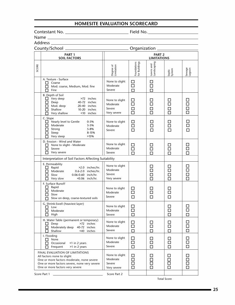
25
FINAL EVALUATION OF LIMITATIONSAll factors none to slightOne or more factors moderate, none severeOne or more factors severe, none very severeOne or more factors very severe
Contestant No. Field No.NameAddressCounty/School Organization
SCO
RE
A. Texture - SurfaceCoarseMod. coarse, Medium, Mod. fi neFine
B. Depth of SoilVery deep >72 inchesDeep 40-72 inchesMod. deep 20-40 inchesShallow 10-20 inchesVery shallow <10 inches
C. SlopeNearly level to Gentle 0-3%Moderate 3-5%Strong 5-8%Steep 8-15%Very steep >15%
D. Erosion - Wind and WaterNone to slight - ModerateSevereVery severe
Deg
ree
ofLi
mita
tion
LowModerate High
I. FloodingNoneOccasional <1 in 2 yearsFrequent >1 in 2 years
G. Shrink-Swell (heaviest layer)
H. Water Table (permanent or temporary)
Sew
age
Lago
on
Sep
ticSy
stem
Deep >72 inchesModerately deep 40-72 inchesShallow <40 inches
Law
ns a
ndLa
ndsc
apin
g
Foun
dat
ions
for
Build
ings
PART 2LIMITATIONS
PART 1SOIL FACTORS
F. Surface RunoffRapidModerate Slow Slow on deep, coarse-textured soils
Rapid >2.0 inches/hr.Moderate 0.6-2.0 inches/hr.Slow 0.06-0.60 inch/hr.Very slow <0.06 inch/hr.
E. Permeability
None to slightModerateSevere
None to slightModerateSevereVery severe
None to slightModerateSevere
None to slightModerateSevere
None to slightModerateSevereVery severe
None to slightModerateSevere
None to slightModerateSevere
None to slightModerateSevere
None to slightModerateSevere
None to slightModerateSevereVery severe
Score Part 1 Score Part 2
Total ScoreKansas State University Agricultural Experiment Station and Cooperative Extension Service S-95K-State Research and Extension is an equal opportunity provider and employer. Issued in furtherance of Co op er a tive Extension Work, Acts of May 8 and June 30, 1914, as amended. Kansas State Uni ver si ty, County Ex ten sion Councils, Extension Districts, and United States De part ment of Ag ri cul ture Cooperating, Fred A. Cholick, Director.
Interpretation of Soil Factors Affecting Suitability
HOMESITE EVALUATION SCORECARD

26
Contestant No. Field No.NameAddressCounty/School Organization
SCORESCORE
A. Texture
Sur. Sub.1. Coarse2. Moderately coarse3. Medium4. Moderately fi ne5. Fine
B. Depth of Soil
1. Deep2. Moderately deep3. Shallow4. Very shallow
C. Slope
1. Nearly level 0-1%2. Gently sloping 1-3%3. Moderately sloping 3-5%4. Strongly sloping 5-8%5. Steep 8-15%6. Very steep >15%
D. Erosion - Wind and Water
1. None to slight2. Moderate3. Severe4. Very severe
E. Permeability1. Rapid2. Moderate3. Slow4. Very slow
F. Surface Runoff1. Rapid2. Moderate3. Slow4. Very slow
G. Major factors that keep fi eld out of Class I
1. Sur. Texture2. Depth3. Slope4. Erosion
5. Permeability6. Runoff7. Wetness8. Flooding
9. None
H. Land Capability Class1. Class I2. Class II3. Class III4. Class IV
A. Vegetative
Use soil conserving and/or soil improving crops:
1. Every 4th or 5th year2. Every 3rd or 4th year3. Every 2nd year4. Every year
5. Maintain crop residue6. Practice conservation tillage7. Establish recommended grass or grasses and legumes8. Proper pasture and range management9. Protect from wildfi res10. Control grazing11. Plant recommended trees12. Harvest trees selectively13. Use only for wildlife or recreation area
B. Mechanical
C. Lime and Nutrients21. Lime22. Phosphorus (P2O5)23. Potassium (K2O)24. Nitrogen (N)25. Lime or nutrients not needed
5. Class V6. Class VI7. Class VII
8. Class VIII
Score Part 1 Score Part 2 Total Score
PART 1SOIL FACTORS
PART 2RECOMMENDED LAND TREATMENTS
Kansas State University Agricultural Experiment Station and Cooperative Extension Service S-96K-State Research and Extension is an equal opportunity provider and employer. Issued in furtherance of Co op er a tive Extension Work, Acts of May 8 and June 30, 1914, as amended. Kansas State Uni ver si ty, County Ex ten sion Councils, Extension Districts, and United States De part ment of Ag ri cul ture Cooperating, Fred A. Cholick, Director.
Interpretation of Soil Factors
14. Control brush or trees15. Terrace and farm on contour16. Maintain terraces17. Construct diversion terraces18. Install drainage system19. Control gullies20. No mechanical treatment needed
LAND JUDGING SCORECARD
S96.indd 1 8/31/04 10:43:05 AM

27

28

Brand names appearing in this publication are for product identification purposes only. No endorsement is intended, nor is criticism implied of similar products not mentioned.
Publications from Kansas State University are available at: www.bookstore.ksre.ksu.edu
Contents of this publication may be freely reproduced for educational purposes. All other rights reserved. In each case, credit DeAnn Presley, Land Judging and Homesite Evaluation Guidebook, Kansas State University, September 2010.
Kansas State University Agricultural Experiment Station and Cooperative Extension Service
S34 September 2010K-State Research and Extension is an equal opportunity provider and employer. Issued in furtherance of Cooperative Extension Work, Acts of May 8 and June 30, 1914, as amended. Kansas State University, County Extension Councils, Extension Districts, and United States Department of Agriculture Cooperating, John D. Floros, Director.


