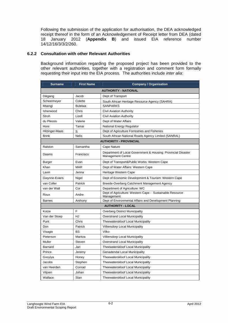
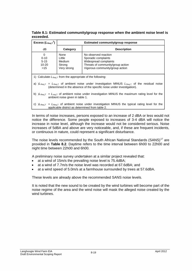
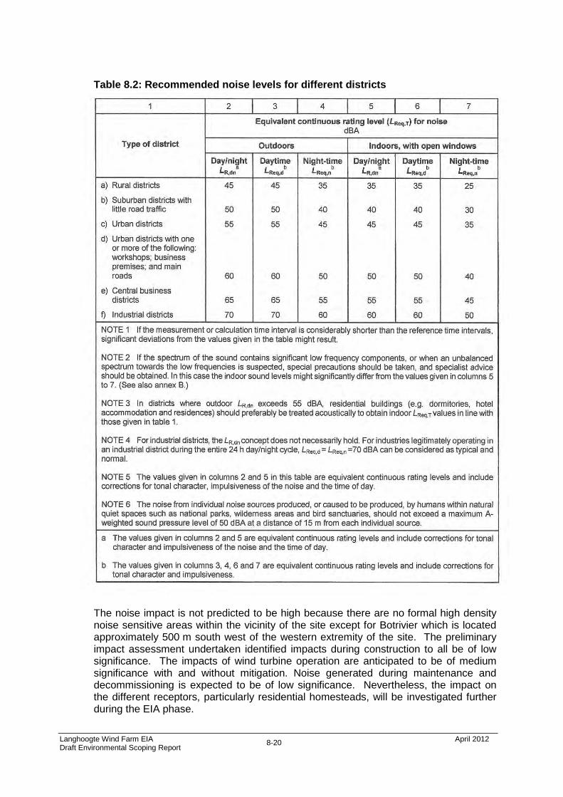
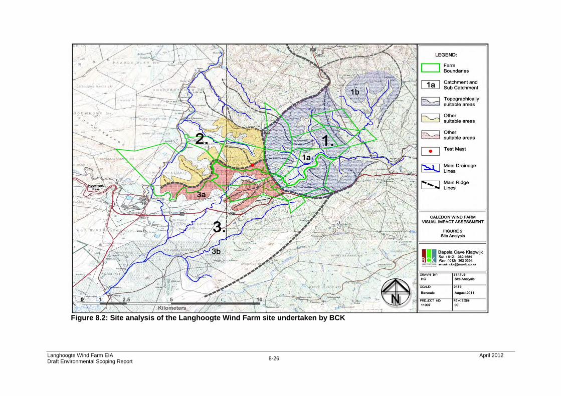
Arcus GIBB (Pty) Ltd Reg. 1992/007139/07 Head Office: Johannesburg, South Africa 14 Eglin Road, Sunninghill, 2191 Tel: +27 11 519 4600 Fax: +27 11 807 5670 SAGIT Energy Ventures (PTY) LTD LANGHOOGTE WIND FARM ENVIRONMENTAL SCOPING REPORT (DRAFT) April 2012 J30284A
Transcript
Arcus GIBB (Pty) Ltd Reg. 1992/007139/07
Head Office: Johannesburg, South Africa 14 Eglin Road, Sunninghill, 2191
Tel: +27 11 519 4600 Fax: +27 11 807 5670
SAGIT Energy Ventures (PTY) LTD
LANGHOOGTE WIND FARM
ENVIRONMENTAL SCOPING REPORT (DRAFT)
April 2012 J30284A
LANGHOOGTE WIND FARM
ENVIRONMENTAL SCOPING REPORT
CONTENTS
Chapter Description Page
1 Introduction 1-1 2 Details of Roleplayers 2-1 3 Project Description 3-1 4 Project Alternatives 4-1 5 Legal and Policy Context 5-1 6 EIA Process and Methodology 6-1 7 The Baseline Environment 7-1 8 Potential Issues and Impacts 8-1 9 Conclusions 9-1 10 Plan of Study for EIA 10-1 APPENDICES Appendix A: Application Form Appendix B: DEA Acknowledgment of Receipt of Application Appendix C: CVs of professional team Appendix D: Issues and Response Report Appendix E1: Ecological Specialist Report Appendix E2: Avifauna Specialist Report Appendix E3: Social Specialist Report Appendix E4: Heritage (Archaeology) Specialist Report Appendix E5: Palaeontology Specialist Report Appendix E6: Noise Specialist Report Appendix E7: Visual Specialist Report Appendix E8 Agriculture Specialist Report Appendix F: PPP Advertisments, Site notices and Posters Appendix G: I&AP database Appendix H: Background Information Document (BID)
Langhoogte Wind Farm EIA April 2012 Draft Environmental Scoping Report
1-1
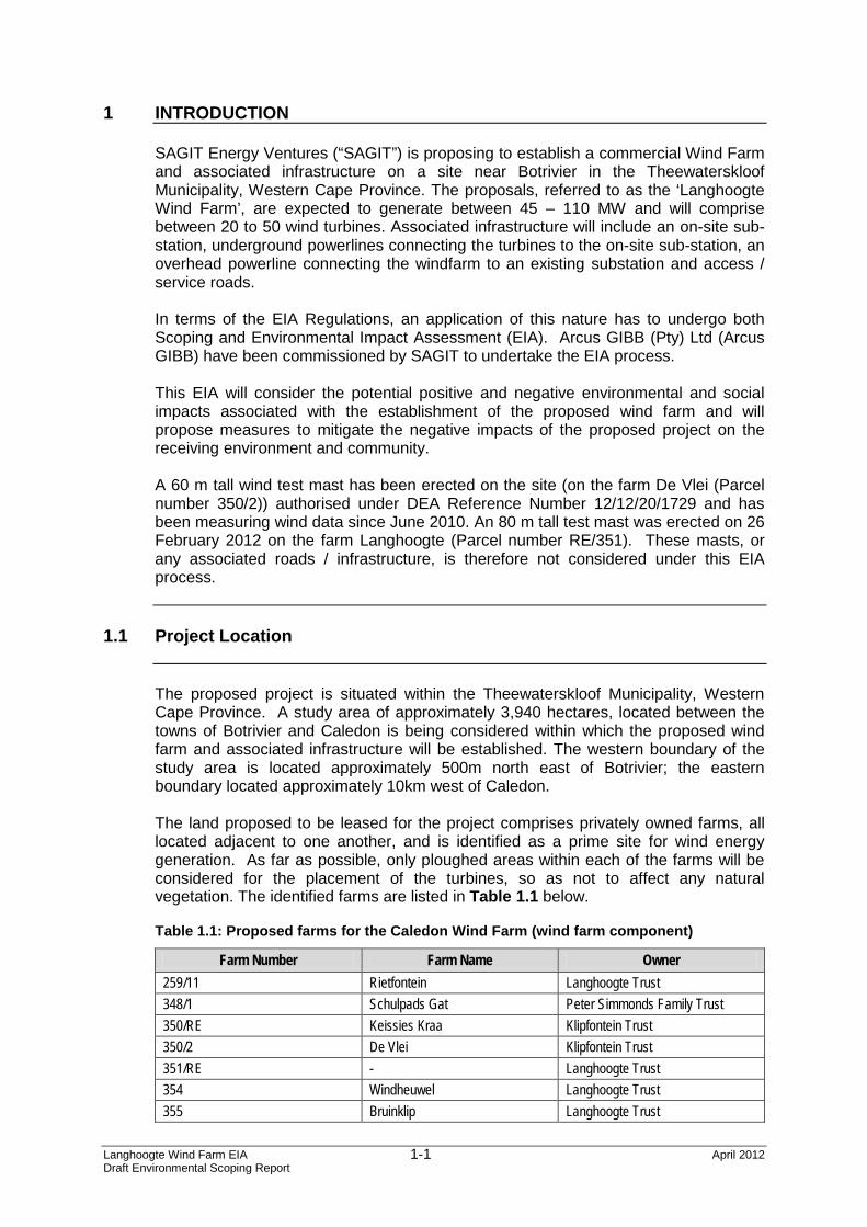
1 INTRODUCTION SAGIT Energy Ventures (“SAGIT”) is proposing to establish a commercial Wind Farm and associated infrastructure on a site near Botrivier in the Theewaterskloof Municipality, Western Cape Province. The proposals, referred to as the ‘Langhoogte Wind Farm’, are expected to generate between 45 – 110 MW and will comprise between 20 to 50 wind turbines. Associated infrastructure will include an on-site sub-station, underground powerlines connecting the turbines to the on-site sub-station, an overhead powerline connecting the windfarm to an existing substation and access / service roads. In terms of the EIA Regulations, an application of this nature has to undergo both Scoping and Environmental Impact Assessment (EIA). Arcus GIBB (Pty) Ltd (Arcus GIBB) have been commissioned by SAGIT to undertake the EIA process.
This EIA will consider the potential positive and negative environmental and social impacts associated with the establishment of the proposed wind farm and will propose measures to mitigate the negative impacts of the proposed project on the receiving environment and community. A 60 m tall wind test mast has been erected on the site (on the farm De Vlei (Parcel number 350/2)) authorised under DEA Reference Number 12/12/20/1729 and has been measuring wind data since June 2010. An 80 m tall test mast was erected on 26 February 2012 on the farm Langhoogte (Parcel number RE/351). These masts, or any associated roads / infrastructure, is therefore not considered under this EIA process.
1.1 Project Location
The proposed project is situated within the Theewaterskloof Municipality, Western Cape Province. A study area of approximately 3,940 hectares, located between the towns of Botrivier and Caledon is being considered within which the proposed wind farm and associated infrastructure will be established. The western boundary of the study area is located approximately 500m north east of Botrivier; the eastern boundary located approximately 10km west of Caledon. The land proposed to be leased for the project comprises privately owned farms, all located adjacent to one another, and is identified as a prime site for wind energy generation. As far as possible, only ploughed areas within each of the farms will be considered for the placement of the turbines, so as not to affect any natural vegetation. The identified farms are listed in Table 1.1 below. Table 1.1: Proposed farms for the Caledon Wind Farm (wind farm component)
Farm Number Farm Name Owner 259/11 Rietfontein Langhoogte Trust 348/1 Schulpads Gat Peter Simmonds Family Trust 350/RE Keissies Kraa Klipfontein Trust 350/2 De Vlei Klipfontein Trust 351/RE - Langhoogte Trust 354 Windheuwel Langhoogte Trust 355 Bruinklip Langhoogte Trust
Langhoogte Wind Farm EIA April 2012 Draft Environmental Scoping Report
1-2
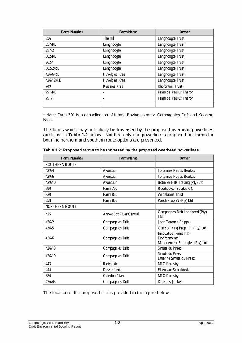
Farm Number Farm Name Owner 356 The Hill Langhoogte Trust 357/RE Langhoogte Langhoogte Trust 357/2 Langhoogte Langhoogte Trust 362/RE Langhoogte Langhoogte Trust 362/1 Langhoogte Langhoogte Trust 362/2/RE Langhoogte Langhoogte Trust 426/6/RE Huveltjies Kraal Langhoogte Trust 426/12/RE Huveltjies Kraal Langhoogte Trust 749 Keissies Kraa Klipfontein Trust 791/RE - Francois Paulus Theron 791/1 - Francois Paulus Theron
* Note: Farm 791 is a consolidation of farms: Baviaanskrantz, Compagnies Drift and Koos se Nest. The farms which may potentially be traversed by the proposed overhead powerlines are listed in Table 1.2 below. Not that only one powerline is proposed but farms for both the northern and southern route options are presented. Table 1.2: Proposed farms to be traversed by the proposed overhead powerlines
Farm Number Farm Name Owner SOUTHERN ROUTE 429/4 Avontuur Johannes Petrus Beukes 429/6 Avontuur Johannes Petrus Beukes 429/10 Avontuur Botrivier Hills Trading (Pty) Ltd 790 Farm 790 Rooiheuwel Estates CC 820 Farm 820 Wildekrans Trust 858 Farm 858 Parch Prop 99 (Pty) Ltd NORTHERN ROUTE
435 Annex Bot River Central Compagnes Drift Landgoed (Pty) Ltd
436/2 Compagnies Drift John Terence Phipps 436/5 Compagnies Drift Crimson King Prop 111 (Pty) Ltd
436/19 Compagnies Drift Smuts du Preez Ettienne Smuts du Preez
443 Rietvlakte MTO Forestry 444 Dassenberg Eben van Schalkwyk 880 Caledon River MTO Forestry 436/45 Compagnies Drift Dr. Koos Jonker
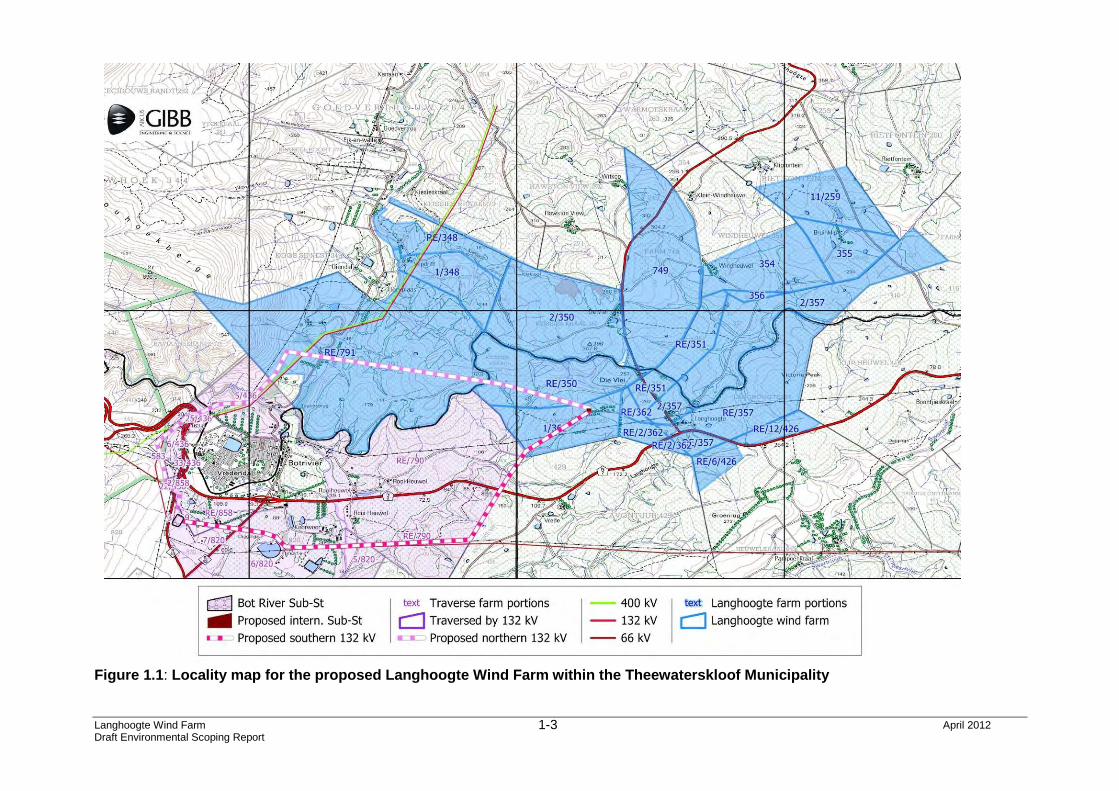
The location of the proposed site is provided in the figure below.
Langhoogte Wind Farm April 2012 Draft Environmental Scoping Report
1-3
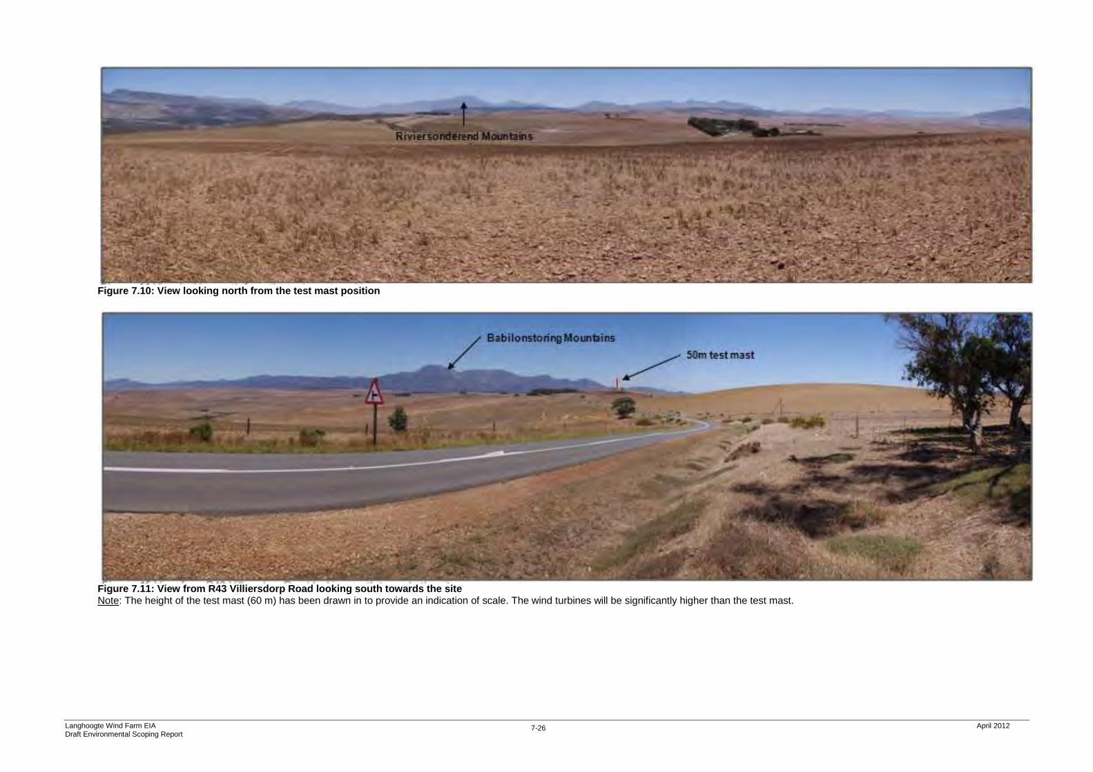
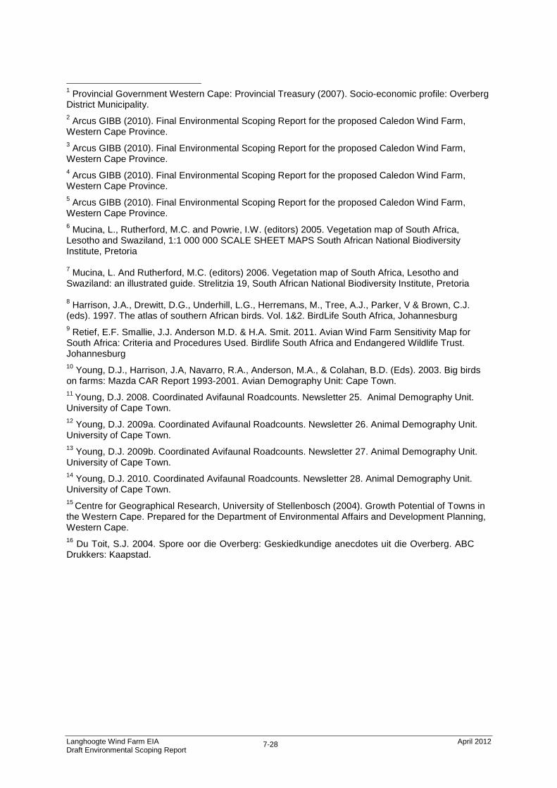
Figure 1.1: Locality map for the proposed Langhoogte Wind Farm within the Theewaterskloof Municipality
Langhoogte Wind Farm EIA April 2012 Draft Environmental Scoping Report
1-4
1.2 Project Description
This section provides an overall description of the proposed wind farm and powerline. Further technical details relating to the project is provided in Chapter 3 of this report.
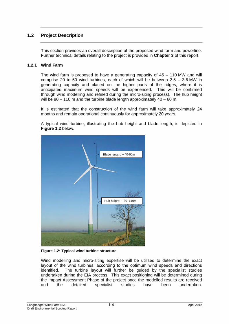
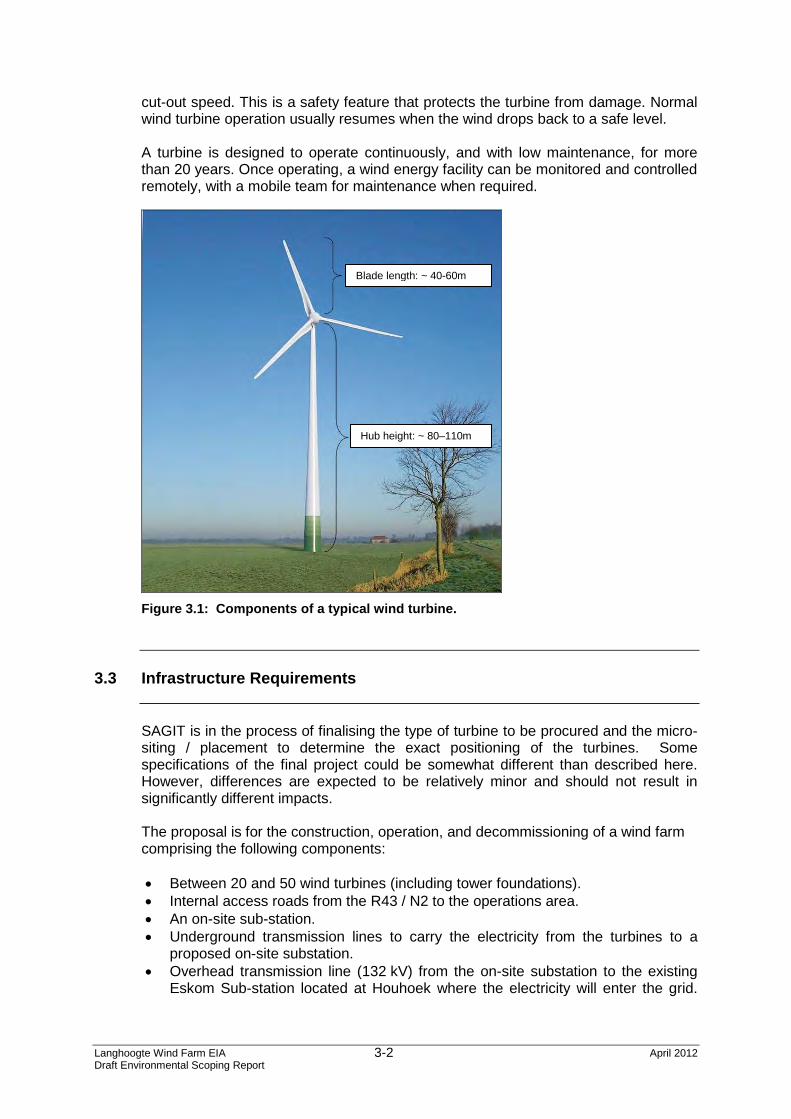
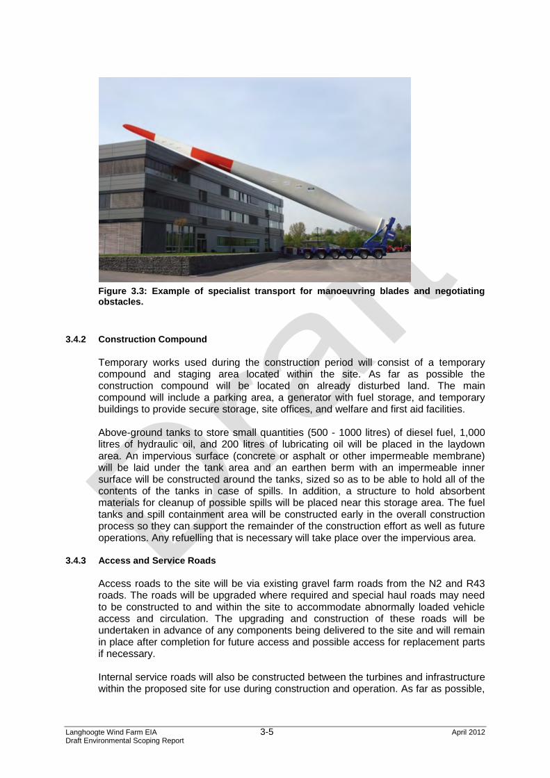
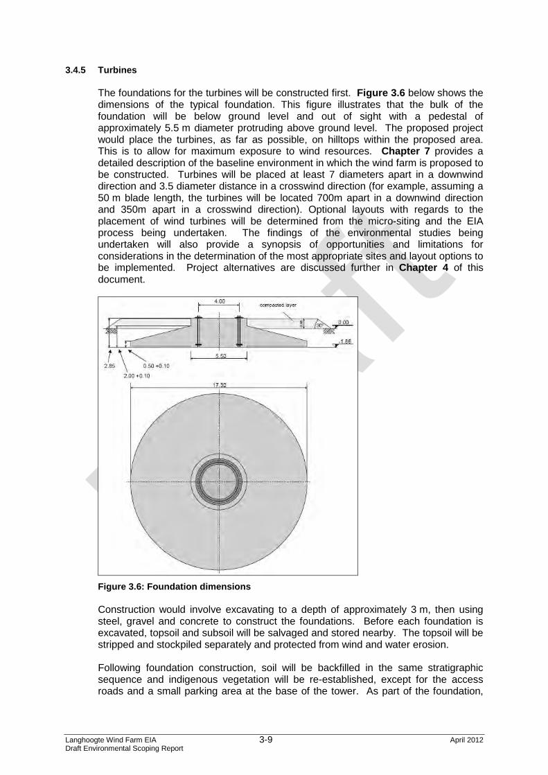
1.2.1 Wind Farm The wind farm is proposed to have a generating capacity of 45 – 110 MW and will comprise 20 to 50 wind turbines, each of which will be between 2.5 – 3.6 MW in generating capacity and placed on the higher parts of the ridges, where it is anticipated maximum wind speeds will be experienced. This will be confirmed through wind modelling and refined during the micro-siting process). The hub height will be 80 – 110 m and the turbine blade length approximately 40 – 60 m. It is estimated that the construction of the wind farm will take approximately 24 months and remain operational continuously for approximately 20 years. A typical wind turbine, illustrating the hub height and blade length, is depicted in Figure 1.2 below.
Figure 1.2: Typical wind turbine structure Wind modelling and micro-siting expertise will be utilised to determine the exact layout of the wind turbines, according to the optimum wind speeds and directions identified. The turbine layout will further be guided by the specialist studies undertaken during the EIA process. This exact positioning will be determined during the Impact Assessment Phase of the project once the modelled results are received and the detailed specialist studies have been undertaken.
Blade length: ~ 40-60m
Hub height: ~ 80–110m
Langhoogte Wind Farm EIA April 2012 Draft Environmental Scoping Report
1-5
1.2.2 Access and Service Roads
Access roads will be required for the delivery of the turbines to their assembly positions during construction, as well as for access and servicing during the operational phase. Access will also be required to a temporary laydown area where vehicles and materials will be stored during the construction phase.
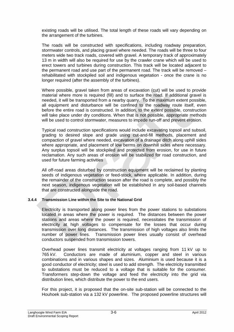
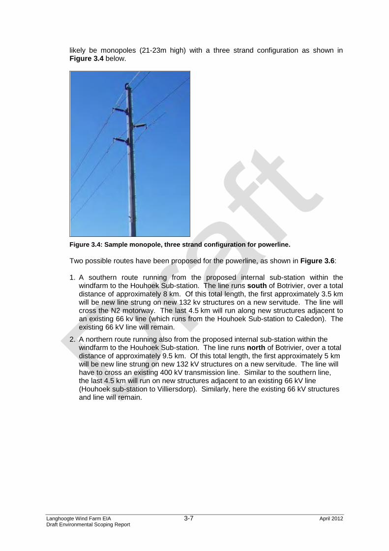
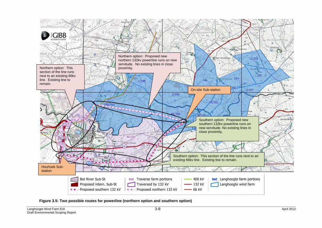
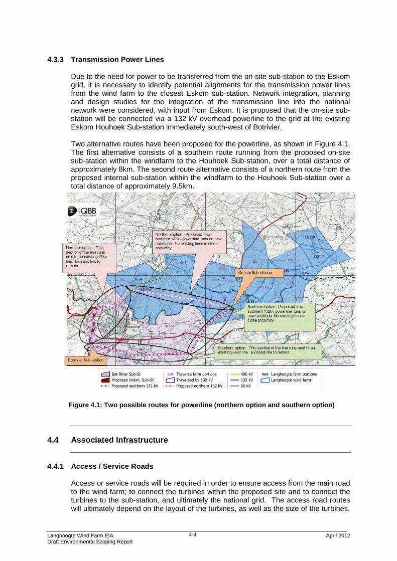
1.2.3 Powerlines and Sub-stations The proposed turbines will be connected via underground powerlines to an on-site sub-station to be constructed. A 132 kV overhead powerline will be constructed to transmit the generated power from the on-site sub-station to the existing Eskom Houhoek sub-station, where it will join the national grid. This existing Houhoek sub-station is located immediately south of Botrivier. Two possible routes for the proposed overhead powerline have been proposed. These are described in detail in Chapter 3 of this report.
1.2.4 Temporary Construction Laydown Area A temporary laydown area will be utilised during the construction phase of the project. This area will be used to store machinery and equipment as well as consist of facilities such as diesel storage facilities, toilets, showers, eating facilities.
1.2.5 Staff Local construction staff will commute from their homes to the site daily. Construction staff from further afield will be accommodated in the nearby towns of Botrivier or Caledon and commute to the site daily.
1.2.6 Wind Farm Control Room A monitoring and control room would could operate from an office located off-site potentially in Botrivier, Caledon or inland (to be determined).
1.2.7 Transport Turbine components and construction materials will be delivered to the site by road from Cape Town along the N2 and R43 or alternatively from Worcester and Villiersdorp via the R43. The turbines will be delivered directly to their point of assembly on site. Where possible, existing farm roads will be upgraded for transport within the proposed site, to the future benefit of the farm owners. It is anticipated that the activities associated with the project described above may have, both positive and negative, potential impacts on the study area, and these will be assessed within this EIA and through the following specialist studies: • Ecology (Flora and Fauna) Impact Assessment • Avifauna Impact Assessment • Social Impact Assessment • Heritage Impact Assessment (including Archaeology) • Noise Impact Assessment • Visual Impact Assessment • Palaeontology Impact Assessment
Langhoogte Wind Farm EIA April 2012 Draft Environmental Scoping Report
1-6
• Agricultural Impact Assessment
1.3 Need and Justification for the Project
1.3.1 Legal Framework for Renewable Energy in South Africa
Electricity generation and provision is a strategic sector of the South African economy underpinning growth and developmental objectives set out by the Government. Over the next few years, the country is expected to experience continued growth in electricity demand, driven by growth in the industrial, mining, commercial and domestic consumer sectors. Several key policies, departments and institutions are responsible for energy planning in South Africa. In terms of energy planning, the South African Energy Policy (December 1998)1 published by the Department of Energy (DoE)*, firstly identifies five key objectives: • Increasing access to affordable energy services; • Improving energy sector governance; • Stimulating economic development; • Managing energy-related environmental impacts; • Securing supply through diversity; and • International Climate Change Commitments under the United Nations Framework
Convention on Climate Change (UNFCCC). In order to meet these objectives as well as the developmental and socio-economic objectives in South Africa, the country needs to make optimal use of available energy resources. The DoE secondly performs Integrated Energy Planning to identify future energy demand and supply requirements. Thirdly, the National Energy Regulator of South Africa (NERSA) performs National Integrated Resource Planning to identify the future electricity demand and supply requirements. The National Energy Act (Act 34 of 2008) aims to ensure that diverse energy resources are available in sustainable quantities and at affordable prices to the South African economy in support of economic growth and poverty alleviation. It recognizes that environmental management requirements are taken into account in planning. The development of renewable energy in South Africa is supported by the White Paper on Renewable Energy (November 2003)2, which has set a target of 10,000 GWh renewable energy contribution to final energy consumption by 2013. This renewable energy is to be mainly produced from biomass, wind, solar and small-scale hydro. The mix and contribution of renewable energy generation types in South Africa has been considered in the National Integrated Resource Plan (IRP) published by the DoE in consultation with NERSA. The IRP was promulgated in May 2011 and sets out the long-term electricity capacity plan for electricity supply over the next 20 years.
* Previously the Department of Minerals and Energy (DME)
Langhoogte Wind Farm EIA April 2012 Draft Environmental Scoping Report
1-7
In the Western Cape, the White Paper on Sustainable Energy for the Western Cape Province (2010) sets out a target of 15% of the electricity consumed in the Province will come from renewable energy sources by 2014 (measured against the 2006 Provincial consumption).
1.3.2 International Commitments Emissions of greenhouse gases such as carbon dioxide from the use of fossil fuels has led to increasing concerns worldwide about global climate change. These concerns were articulated at the Johannesburg World Summit on Sustainable Development in 2002 and a corresponding commitment to promote renewable energy in all the participating nations was made in the Johannesburg Declaration. Accordingly, it is the intention of the South African Government to make South Africa’s due contribution to the global effort to mitigate greenhouse gas emissions. By ratifying the UNFCCC (1997) and the Kyoto Protocol (2002), South Africa has made international commitments to reduce green house gases emissions so as to prevent dangerous anthropogenic interference with the climate system.
1.3.3 Benefits of a Wind Farm Renewable energy that is produced from sustainable natural sources will provide incremental financial resources to stimulate sustainable development. Further, it will contribute towards the country meeting its international commitments made in respect of green house gas emissions (Copenhagen Accord), as well as government’s objectives set out in the White Paper on Renewable Energy.
Wind energy is plentiful, renewable, widely distributed, clean, and reduces greenhouse gas emissions when it displaces fossil fuel derived electricity. It is thus attractive to many governments, organizations, and individuals. As most of the sources are indigenous and naturally available, wind energy is secure in that it is not subject to disruption by international crises or limited supplies, being naturally available. For the Western Cape specifically, as a net importer of electricity, wind energy hold great appeal. The transmission of electricity over the distances involved, results in a significant loss of energy between the amounts generated in Mpumalanga and what is available in the Western Cape. The location of the proposed wind farm in the Western Cape will also mean a reduction in line losses as the wind farm will be located close to the customer load demand. Furthermore, there are no deposits of coal to enable power stations to be built closer to the Western Cape, making the generation of electricity in the Western Cape possible only through Nuclear power or Renewable generation. Typical benefits associated with wind farms are: • Wind energy is renewable, clean and non-polluting, and does not produce by-products
(atmospheric contaminants or thermal pollution) that could be harmful to the environment; • Wind farms are well suited to rural areas and therefore have a reduced impact on
agriculture compared to other electricity generating options. Wind turbines can also contribute to economic growth in these regions;
• Wind turbines make use of relatively simple technology in terms of design and construction;
• Wind energy is competitively priced compared to other renewable energy sources; • Localized production of energy reduces transmission line losses associated with
Langhoogte Wind Farm EIA April 2012 Draft Environmental Scoping Report
1-8
transmitting electricity over long distances; • The use of wind turbines displaces the use of coal and other fossil fuels with their
associated emissions of greenhouse gases; and • Wind Farms improve energy security for South Africa and the Western Cape, reducing
dependency on imported fossil fuels. • Access to international funding for energy projects. • Access to technology for creation of manufacturing industry within the renewable energy
technology sector.
1.4 Environmental Study Requirements
In terms of the EIA Regulations published in Government Notice R543 of 18 June 2010 in terms of Section 24 (5) of the National Environmental Management Act (Act No. 107 of 1998), certain listed activities as set out in Government Notices R544 and R546 (activities that trigger Basic Assessments) and R545 (activities triggering Scoping and Environmental Impact Assessment processes or full EIAs) require environmental authorisation before they can proceed.
This proposed wind farm development comprises several activities listed in terms of the EIA Regulations (2010), which should be covered in a single application for authorisation. These listed activities are listed in Table 1.1 below.
Langhoogte Wind Farm EIA April 2012 Draft Environmental Scoping Report
1-9
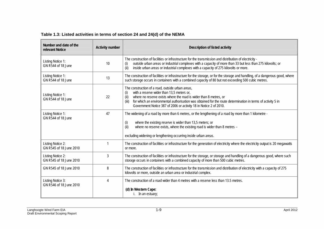
Table 1.3: Listed activities in terms of section 24 and 24(d) of the NEMA
Number and date of the relevant Notice Activity number Description of listed activity
Listing Notice 1: GN R544 of 18 June 10
The construction of facilities or infrastructure for the transmission and distribution of electricity - (i) outside urban areas or industrial complexes with a capacity of more than 33 but less than 275 kilovolts; or (ii) inside urban areas or industrial complexes with a capacity of 275 kilovolts or more.
Listing Notice 1: GN R544 of 18 June 13 The construction of facilities or infrastructure for the storage, or for the storage and handling, of a dangerous good, where
such storage occurs in containers with a combined capacity of 80 but not exceeding 500 cubic metres.
Listing Notice 1: GN R544 of 18 June 22
The construction of a road, outside urban areas, (i) with a reserve wider than 13,5 meters or, (ii) where no reserve exists where the road is wider than 8 metres, or (iii) for which an environmental authorisation was obtained for the route determination in terms of activity 5 in
Government Notice 387 of 2006 or activity 18 in Notice 2 of 2010.
Listing Notice 1: GN R544 of 18 June
47 The widening of a road by more than 6 metres, or the lengthening of a road by more than 1 kilometre - (i) where the existing reserve is wider than 13,5 meters; or (ii) where no reserve exists, where the existing road is wider than 8 metres – excluding widening or lengthening occurring inside urban areas.
Listing Notice 2: GN R545 of 18 June 2010
1 The construction of facilities or infrastructure for the generation of electricity where the electricity output is 20 megawatts or more.
Listing Notice 2: GN R545 of 18 June 2010
3 The construction of facilities or infrastructure for the storage, or storage and handling of a dangerous good, where such storage occurs in containers with a combined capacity of more than 500 cubic metres.
GN R545 of 18 June 2010 8 The construction of facilities or infrastructure for the transmission and distribution of electricity with a capacity of 275 kilovolts or more, outside an urban area or industrial complex.
Listing Notice 3: GN R546 of 18 June 2010
4 The construction of a road wider than 4 metres with a reserve less than 13.5 metres. (d) In Western Cape:
i. In an estuary;
Langhoogte Wind Farm EIA April 2012 Draft Environmental Scoping Report
1-10
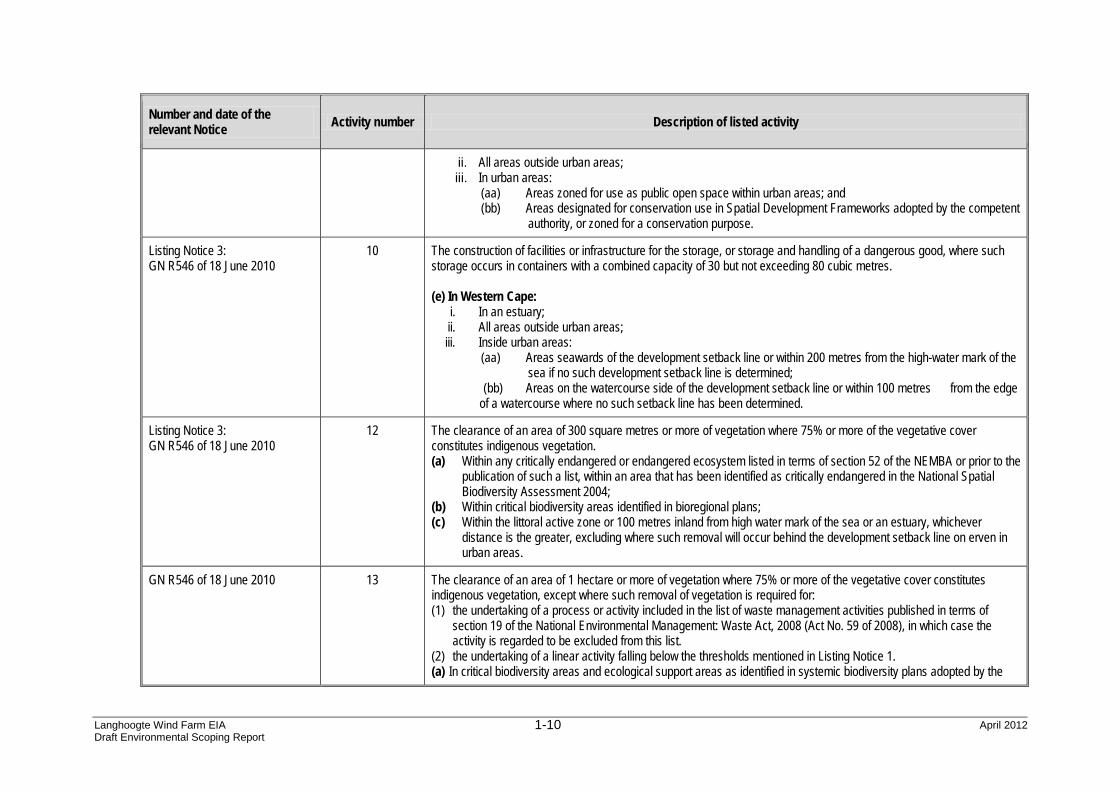
Number and date of the relevant Notice Activity number Description of listed activity
ii. All areas outside urban areas; iii. In urban areas:
(aa) Areas zoned for use as public open space within urban areas; and (bb) Areas designated for conservation use in Spatial Development Frameworks adopted by the competent
authority, or zoned for a conservation purpose.
Listing Notice 3: GN R546 of 18 June 2010
10 The construction of facilities or infrastructure for the storage, or storage and handling of a dangerous good, where such storage occurs in containers with a combined capacity of 30 but not exceeding 80 cubic metres. (e) In Western Cape:
i. In an estuary; ii. All areas outside urban areas; iii. Inside urban areas:
(aa) Areas seawards of the development setback line or within 200 metres from the high-water mark of the sea if no such development setback line is determined;
(bb) Areas on the watercourse side of the development setback line or within 100 metres from the edge of a watercourse where no such setback line has been determined.
Listing Notice 3: GN R546 of 18 June 2010
12 The clearance of an area of 300 square metres or more of vegetation where 75% or more of the vegetative cover constitutes indigenous vegetation. (a) Within any critically endangered or endangered ecosystem listed in terms of section 52 of the NEMBA or prior to the
publication of such a list, within an area that has been identified as critically endangered in the National Spatial Biodiversity Assessment 2004;
(b) Within critical biodiversity areas identified in bioregional plans; (c) Within the littoral active zone or 100 metres inland from high water mark of the sea or an estuary, whichever
distance is the greater, excluding where such removal will occur behind the development setback line on erven in urban areas.
GN R546 of 18 June 2010 13 The clearance of an area of 1 hectare or more of vegetation where 75% or more of the vegetative cover constitutes indigenous vegetation, except where such removal of vegetation is required for: (1) the undertaking of a process or activity included in the list of waste management activities published in terms of
section 19 of the National Environmental Management: Waste Act, 2008 (Act No. 59 of 2008), in which case the activity is regarded to be excluded from this list.
(2) the undertaking of a linear activity falling below the thresholds mentioned in Listing Notice 1. (a) In critical biodiversity areas and ecological support areas as identified in systemic biodiversity plans adopted by the
Langhoogte Wind Farm EIA April 2012 Draft Environmental Scoping Report
1-11
Number and date of the relevant Notice Activity number Description of listed activity
competent authority. (b) National Protected Area Expansion Strategy Focus areas. (c) In the Western Cape:
i. Outside urban areas, the following: (aa) A protected area identified in terms of NEMPAA, excluding conservancies; (bb) National Protected Area Expansion Strategy Focus areas; (cc) Sensitive areas as identified in an environmental management framework as contemplated in chapter
5 of the Act and as adopted by the competent authority; (dd) Sites or areas identified in terms of an International Convention; (ee) Core areas in biosphere reserves; (ff) Areas within10 kilometres from national parks or world heritage sites or 5 kilometres from any other
protected area identified in terms of NEMPAA or from the core area of a biosphere reserve; (gg) Areas seawards of the development setback line or within 1 kilometre from the high-water mark of the
sea if no such development setback line is determined.
Listing Notice 3: GN R546 of 18 June 2010 – Requiring a BA
14 The clearance of an area of 5 hectares or more of vegetation where 75% or more of the vegetative cover constitutes indigenous vegetation, except where such removal of vegetation is required for: (1) purposes of agriculture or afforestation inside areas identified in spatial instruments adopted by the competent
authority for agriculture or afforestation purposes; (2) the undertaking of a process or activity included in the list of waste management activities published in terms of section
19 of the National Environmental Management: Waste Act, 2008 (Act No. 59 of 2008) in which case the activity is regarded to be excluded from this list;
(3) the undertaking of a linear activity falling below the thresholds in Notice 544 of 2010.
Listing Notice 3: GN R546 of 18 June 2010 – Requiring an EIA
19 The widening of a road by more than 4 metres, or the lengthening of a road by more than 1 kilometre. (d) In Western Cape:
i. In an estuary; ii. All areas outside urban areas; iii. In urban areas:
(aa) Areas zoned for use as public open space within urban areas; (bb) Areas designated for conservation use in Spatial Development Frameworks adopted by the competent
authority, or zoned for a conservation purpose, within urban areas.
Langhoogte Wind Farm EIA April 2012 Draft Environmental Scoping Report
1-12
SAGIT therefore requires authorisation from the National Department of Environmental Affairs (DEA) in consultation with the Western Cape Department of Environmental Affairs and Development Planning (DEA&DP) for undertaking the proposed Project. In order to obtain authorisation for this project, comprehensive, independent environmental studies must be undertaken in accordance with the EIA Regulations. An Application Form (Appendix A) was submitted to the DEA on 12 December 2012. The application was subsequently acknowledged by the DEA in a letter dated 18 January 2012 (Appendix B). The application has been assigned the DEA reference number 14/12/16/3/3/2/260. SAGIT has appointed Arcus GIBB as independent Environmental Assessment Practitioner (EAP) to manage the application and to undertake environmental studies together with a team of specialists. Through this process Arcus GIBB and the relevant specialists will identify and assess all potential environmental impacts associated with the proposed Project. The environmental studies will follow a two-phased approach in accordance with the EIA Regulations: • Phase 1: Environmental Scoping Study • Phase 2: Environmental Impact Assessment (EIA). This report constitutes the Draft Environmental Scoping Report and sets out the findings of the Environmental Scoping Study undertaken to identify and describe the potential environmental impacts associated with all aspects of the proposed project. In terms of the EIA Regulations, feasible and reasonable alternatives have been discussed within the Scoping Study (Chapter 4). Recommendations regarding the detailed studies required within the Impact Assessment phase of the project have been made in Chapter 10.
1.5 Summary of the EIA Process
1.5.1 EIA Process
An EIA is a legislative tool that is used to ensure that potential impacts that may occur due to the proposed development are avoided or mitigated (minimised). In South African legislation the environment includes social, economic and bio-physical aspects and the EIA must assess these equitably.
The EIA procedures are based on the principles of Integrated Environmental Management (IEM) which, in short, comprise pro-active planning, informed decision making, a transparent and participatory approach to development, a broad understanding of the environment, and accountability for decisions and the information on which they are based.
As previously noted, the EIA process is controlled through regulations published under the Government Notice No. R. 543, R. 544, R. 545 and R. 546 and associated
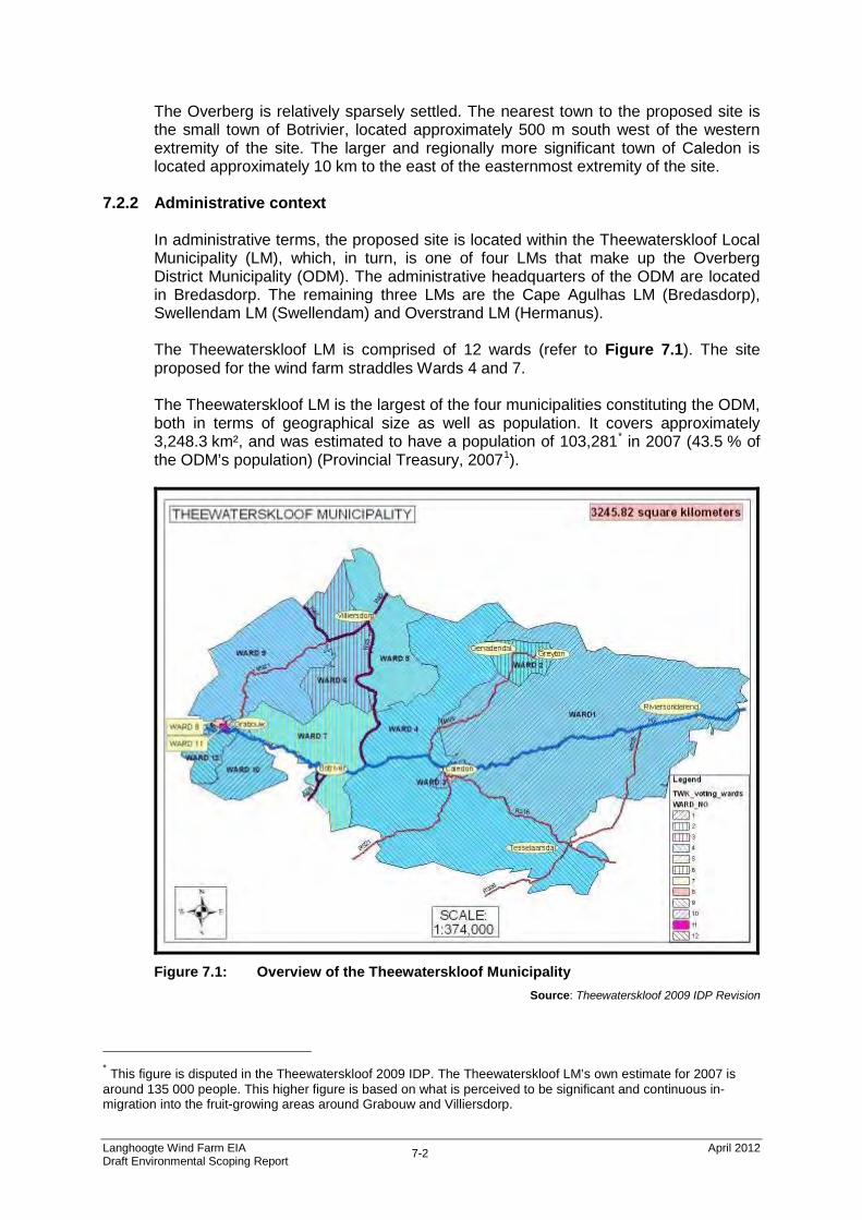
Langhoogte Wind Farm EIA April 2012 Draft Environmental Scoping Report
1-13
guidelines promulgated in terms of Chapter 5 of the National Environmental Management Act (Act 107 of 1998).
The EIA process can be divided into 4 distinct components:
1. Application and initial notification
• Submit an EIA application to the DEA • DEA acknowledgement of the EIA application (within 14 days), • Notify the public of the proposed development through inter alia, newspaper
adverts, notification letters, BIDs and notice boards. Call for registration of I&APs.
2. Scoping phase
• Investigate and gather information on the proposed study area in order to establish an understanding of the area;
• Establish how the proposed project will potentially impact on the surrounding environment;
• Identify Interested and Affected Parties (I&APs) and relevant authorities by conducting a Public Participation Process (PPP);
• Identify potential environmental impacts through investigation and PPP; and • Describe and investigate the alternatives that may be considered.
3. Impact Assessment phase
• Detailed specialist assessment of all issues and proposed alternatives identified in the Scoping phase;
• Identify mitigation measures and recommendations to reduce the significance of potential impacts;
• Compile an Environmental Management Plan (EMP) which will prescribe environmental specifications to be adhered to during the construction and operational phases of the project; and
• Continue with the PPP with registered I&APs as an integral and important part of the Impact Assessment phase.
4. Environmental Authorisation
• Environmental Authorisation (EA) issued to SAGIT once DEA has made a decision regarding the proposed project.
• The decision may be positive or negative based on inter alia, information received in the Scoping and Impact Assessment phases.
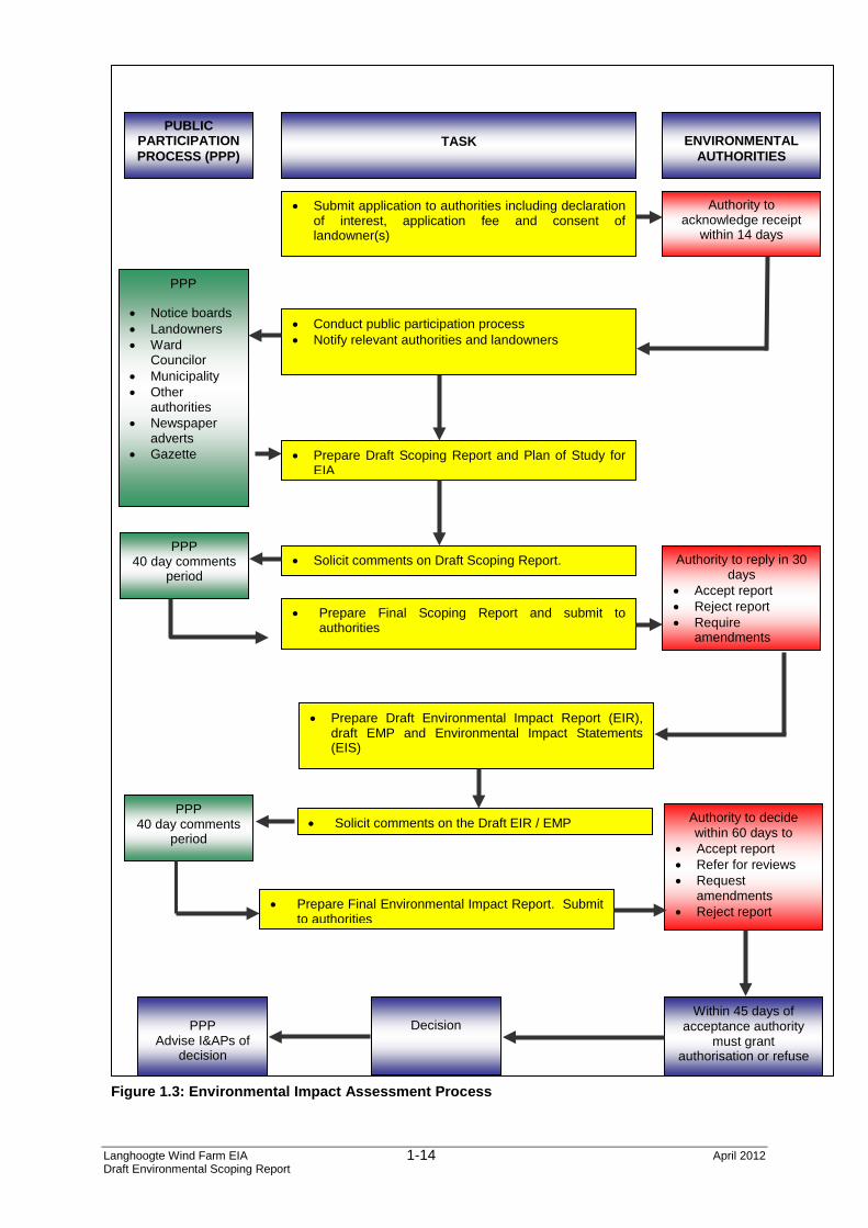
The full EIA Process and timeframes are discussed in further detail in Chapter 6. The EIA process and appeal process as legislated in terms of NEMA is shown diagrammatically in Figure 1.3Error! Reference source not found. below.
Langhoogte Wind Farm EIA April 2012 Draft Environmental Scoping Report
1-14
• Submit application to authorities including declaration of interest, application fee and consent of landowner(s)
• Conduct public participation process • Notify relevant authorities and landowners
• Prepare Draft Scoping Report and Plan of Study for EIA
• Prepare Final Scoping Report and submit to authorities
• Prepare Final Environmental Impact Report. Submit to authorities
Figure 1.3: Environmental Impact Assessment Process
Langhoogte Wind Farm EIA April 2012 Draft Environmental Scoping Report
1-15
1.6 Way Forward
The Draft Scoping Report (DSR), including the Plan of Study (PoS) for EIA, will distributed for public comment for a period of 40 calendar days. All comments received on the DSR will be considered, and a response thereto will provided within an Issues and Response Report (IRR), attached as an Appendix to the Final Scoping Report which will be submitted to the DEA and the DEA&DP for their consideration. It is protocol that DEA&DP will provide comment to the DEA on the adequacy of the Final Scoping Report, and that the DEA will consider these comments prior to making a decision on this report. If the report is adequate then the DEA will instruct the EAP to continue on to the next phase of the EIA process.
1 Department of Minerals and Energy (December 1998). White Paper on the Energy Policy of the Republic of South Africa. 2 Department of Minerals and Energy (November 2011). White Paper on Renewable Energy.
This Scoping Report was compiled in line with the requirements of the NEMA EIA Regulations and has provided a brief description of the pre-development biophysical and socio-economic environment of the broader region, a description of the nature and extent of the project, as well as the potential issues identified and evaluated to date in the Scoping phase of the EIA. This chapter provides the context for the Plan of Study for the Impact Assessment phase of the project. The Plan of Study describes how the Impact Assessment phase of the project will proceed and provides the terms of reference for specialists, the impact assessment methodology to be used to rate impacts as well as clearly indicating the deliverables of the Impact Assessment phase and the proposed timeframe. Following acceptance of the Scoping Report by the DEA, the detailed Impact Assessment phase of the EIA process will commence. This phase considers the potential impacts identified for the proposed project on the environment taking into account the following: • Potential impacts of the proposed project during the construction phase;
• Potential impacts of the proposed project during the operational phase;
• Potential impacts of the proposed project during the decommissioning phase; and
• The potential cumulative impacts of the proposed project.
10.2 Purpose of the Plan of Study for EIA
The Plan of Study for EIA sets out the proposed approach to the EIA. The following requirements of Regulation 28 of Government Notice R. 543 promulgated in terms of section 24 of NEMA have been considered in compiling this Plan of Study for EIA: • A description of the tasks that will be undertaken as part of the environmental
impact assessment process, including any specialist reports or specialised processes, and the manner in which such tasks will be undertaken;
• An indication of the stages at which the competent authority will be consulted; • A description of the proposed method of assessing the environmental issues
and alternatives, including the option of not proceeding with the activity; and • Particulars of the public participation process that will be conducted during
The purpose of the Impact Assessment phase of an EIA is to: • Address issues that have been raised during the Scoping phase;
• Assess alternatives to the proposed activity in a comparative manner;
• Assess all identified impacts and determine the significance of each impact; and
• Formulate mitigation measures in order to minimise negative impacts and optimise the effects of positive impacts.
Numerous acceptable approaches and methodologies exist by which the above purpose can be achieved. The legislation in South Africa, including the guideline documents published in support thereof, does not provide a specific methodology for the assessment of impacts. Rather, an assessment framework is provided within which Environmental Assessment Practitioners (EAPs) are expected to structure a project-specific assessment methodology. This assessment framework recognises that there are different methodologies available for assessing the impact of a development but that the specific methodology selected must provide for the following1: • A clear process for impact identification, prediction and evaluation;
• The specification of impact identification techniques;
• Criteria for evaluating the significance of impacts;
• The design of mitigation measures to address impacts;
• Defining types of impacts (direct, indirect or cumulative); and
• Specification of uncertainties. The Plan of Study for proposed by Arcus GIBB is set out below. It describes the manner in which Arcus GIBB, as the appointed EAP, intends undertaking the detailed Impact Assessment phase of the EIA process. To ensure consistency in the assessment, all the specialists will be required to make use of the same assessment methodology.
10.3.2 Impact Assessment Methodology The objective of the assessment of impacts is to identify and assess all the significant impacts that may arise because of the proposed Langhoogte Wind
Farm and associated infrastructure. The process of assessing the potential impacts of the project encompasses the following four activities: • Identification and assessment of potential impacts;
• Prediction of the nature, magnitude, extent and duration of potentially significant impacts;
• Identification of mitigation measures that could be implemented to reduce the severity or significance of the impacts of the activity; and
• Evaluation of the significance of the impact after the mitigation measures have been implemented i.e. the significance of the residual impact.
The possible impacts associated with the proposed Langhoogte Wind Farm are identified in the Scoping phase through public and stakeholder consultation, as well as through input from the authorities and the EIA team. These impacts are derived from the issues that are identified in respect of all phases of the development including the construction and operational phases. During the detailed Impact Assessment phase of the EIA process, additional impacts will be identified through the various specialist studies to be undertaken and through the ongoing consultation process with I&APs. In accordance with GN R 543 of 2010, promulgated in terms of section 24 of NEMA, specialists will be required to assess the significance of potential impacts in terms of the following criteria: • Cumulative impacts; • Nature of the impact; • Extent of the impact; • Probability of the impact occurring; • The degree to which the impact can be reversed; • The degree to which the impact may cause irreplaceable loss of
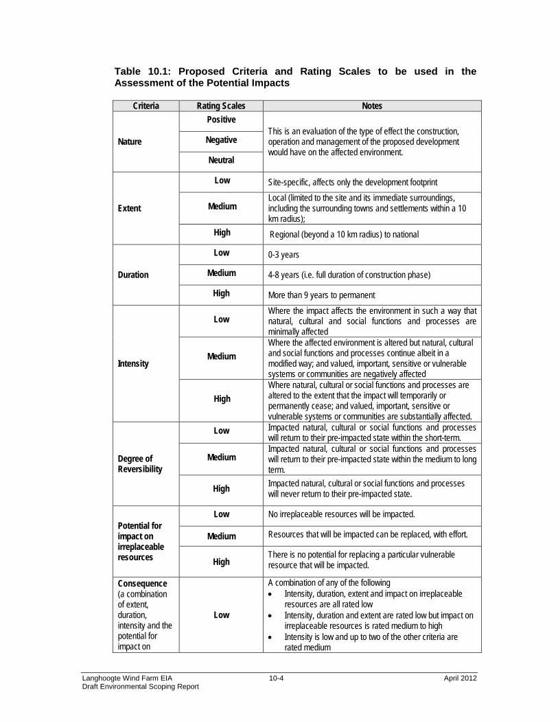
resources; and • The degree to which the impact can be mitigated. Table 10.1 provides a summary of the criteria which Arcus GIBB proposes to use to assess the significance of the potential impacts identified. An explanation of these impact criteria is provided in Table 10.2.
Table 10.1: Proposed Criteria and Rating Scales to be used in the Assessment of the Potential Impacts
Criteria Rating Scales Notes
Nature
Positive This is an evaluation of the type of effect the construction, operation and management of the proposed development would have on the affected environment.
Negative
Neutral
Extent
Low Site-specific, affects only the development footprint
Medium Local (limited to the site and its immediate surroundings, including the surrounding towns and settlements within a 10 km radius);
High Regional (beyond a 10 km radius) to national
Duration
Low 0-3 years
Medium 4-8 years (i.e. full duration of construction phase)
High More than 9 years to permanent
Intensity
Low Where the impact affects the environment in such a way that natural, cultural and social functions and processes are minimally affected
Medium Where the affected environment is altered but natural, cultural and social functions and processes continue albeit in a modified way; and valued, important, sensitive or vulnerable systems or communities are negatively affected
High Where natural, cultural or social functions and processes are altered to the extent that the impact will temporarily or permanently cease; and valued, important, sensitive or vulnerable systems or communities are substantially affected.
Degree of Reversibility
Low Impacted natural, cultural or social functions and processes will return to their pre-impacted state within the short-term.
Medium Impacted natural, cultural or social functions and processes will return to their pre-impacted state within the medium to long term.
High Impacted natural, cultural or social functions and processes will never return to their pre-impacted state.
Potential for impact on irreplaceable resources
Low No irreplaceable resources will be impacted.
Medium Resources that will be impacted can be replaced, with effort.
High There is no potential for replacing a particular vulnerable resource that will be impacted.
Consequence (a combination of extent, duration, intensity and the potential for impact on
Low
A combination of any of the following • Intensity, duration, extent and impact on irreplaceable
resources are all rated low • Intensity, duration and extent are rated low but impact on
irreplaceable resources is rated medium to high • Intensity is low and up to two of the other criteria are
• Intensity is medium and all three other criteria are rated low
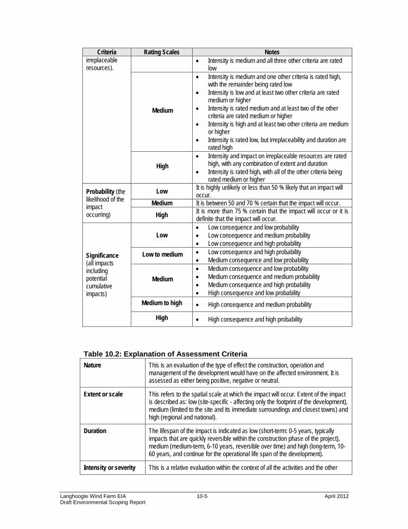
Medium
• Intensity is medium and one other criteria is rated high, with the remainder being rated low
• Intensity is low and at least two other criteria are rated medium or higher
• Intensity is rated medium and at least two of the other criteria are rated medium or higher
• Intensity is high and at least two other criteria are medium or higher
• Intensity is rated low, but irreplaceability and duration are rated high
High • Intensity and impact on irreplaceable resources are rated
high, with any combination of extent and duration • Intensity is rated high, with all of the other criteria being
rated medium or higher
Probability (the likelihood of the impact occurring)
Low It is highly unlikely or less than 50 % likely that an impact will occur.
Medium It is between 50 and 70 % certain that the impact will occur.
High It is more than 75 % certain that the impact will occur or it is definite that the impact will occur.
Significance (all impacts including potential cumulative impacts)
Low • Low consequence and low probability • Low consequence and medium probability • Low consequence and high probability
Low to medium • Low consequence and high probability • Medium consequence and low probability
Medium • Medium consequence and low probability • Medium consequence and medium probability • Medium consequence and high probability • High consequence and low probability
Medium to high • High consequence and medium probability
High • High consequence and high probability Table 10.2: Explanation of Assessment Criteria Nature This is an evaluation of the type of effect the construction, operation and
management of the development would have on the affected environment. It is assessed as either being positive, negative or neutral.
Extent or scale This refers to the spatial scale at which the impact will occur. Extent of the impact is described as: low (site-specific - affecting only the footprint of the development), medium (limited to the site and its immediate surroundings and closest towns) and high (regional and national).
Duration The lifespan of the impact is indicated as low (short-term: 0-5 years, typically impacts that are quickly reversible within the construction phase of the project), medium (medium-term, 6-10 years, reversible over time) and high (long-term, 10-60 years, and continue for the operational life span of the development).
Intensity or severity This is a relative evaluation within the context of all the activities and the other
impacts within the framework of the project. Does the activity destroy the impacted environment, alter its functioning, or render it slightly altered? The specialist studies should, where possible, attempt to quantify the magnitude of the impacts and outline the rationale used.
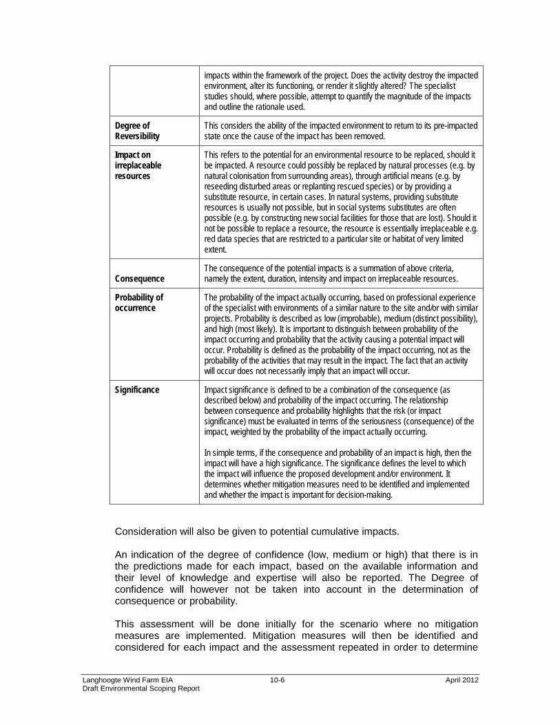
Degree of Reversibility
This considers the ability of the impacted environment to return to its pre-impacted state once the cause of the impact has been removed.
Impact on irreplaceable resources
This refers to the potential for an environmental resource to be replaced, should it be impacted. A resource could possibly be replaced by natural processes (e.g. by natural colonisation from surrounding areas), through artificial means (e.g. by reseeding disturbed areas or replanting rescued species) or by providing a substitute resource, in certain cases. In natural systems, providing substitute resources is usually not possible, but in social systems substitutes are often possible (e.g. by constructing new social facilities for those that are lost). Should it not be possible to replace a resource, the resource is essentially irreplaceable e.g. red data species that are restricted to a particular site or habitat of very limited extent.
Consequence
The consequence of the potential impacts is a summation of above criteria, namely the extent, duration, intensity and impact on irreplaceable resources.
Probability of occurrence
The probability of the impact actually occurring, based on professional experience of the specialist with environments of a similar nature to the site and/or with similar projects. Probability is described as low (improbable), medium (distinct possibility), and high (most likely). It is important to distinguish between probability of the impact occurring and probability that the activity causing a potential impact will occur. Probability is defined as the probability of the impact occurring, not as the probability of the activities that may result in the impact. The fact that an activity will occur does not necessarily imply that an impact will occur.
Significance Impact significance is defined to be a combination of the consequence (as described below) and probability of the impact occurring. The relationship between consequence and probability highlights that the risk (or impact significance) must be evaluated in terms of the seriousness (consequence) of the impact, weighted by the probability of the impact actually occurring. In simple terms, if the consequence and probability of an impact is high, then the impact will have a high significance. The significance defines the level to which the impact will influence the proposed development and/or environment. It determines whether mitigation measures need to be identified and implemented and whether the impact is important for decision-making.
Consideration will also be given to potential cumulative impacts. An indication of the degree of confidence (low, medium or high) that there is in the predictions made for each impact, based on the available information and their level of knowledge and expertise will also be reported. The Degree of confidence will however not be taken into account in the determination of consequence or probability. This assessment will be done initially for the scenario where no mitigation measures are implemented. Mitigation measures will then be identified and considered for each impact and the assessment repeated in order to determine
the significance of the residual impacts (the impact remaining after the mitigation measure has been implemented). The results of the assessment of the significance of the residual impacts will then be linked to decision-making by authorities in the following manner: • Low – will not have an influence on the decision to proceed with the
proposed project, provided that recommended mitigation measures are implemented;
• Medium – should influence the decision to proceed with the proposed project, provided that recommended mitigation measures are implemented; and
• High – would strongly influence the decision to proceed with the proposed project regardless of the implementation of recommended mitigation measures.
10.3.3 Consideration of Alternatives
The following project alternatives will be investigated in the EIA:
• The “do nothing” or ‘no-go’ alternative: The ‘do-nothing’ alternative is the option of not establishing the proposed wind farm.
• Layout and design alternatives (site specific): This includes micro-siting (positioning) for the turbines, varying turbine sizes from 2.5 MW to 3.6 MW and the alignment and placement of the transmission lines connecting the wind farm to the grid.
• Associated Infrastructure: The alignment of the 132kV overhead powerline, various access roads and proposed substation.
During the selection of the most suitable project alternatives, the following principles will be taken into consideration: • The opinion of the public, ascertained through the public consultation
process; • Specialists’ recommendations; • Environmental constraints; • Minimal environmental impacts; • Optimisation of existing infrastructure, such as access roads and power
lines; • Technical and feasibility studies; and • Economic cost-benefit analyses.
10.3.4 Assessment of Potential Impacts
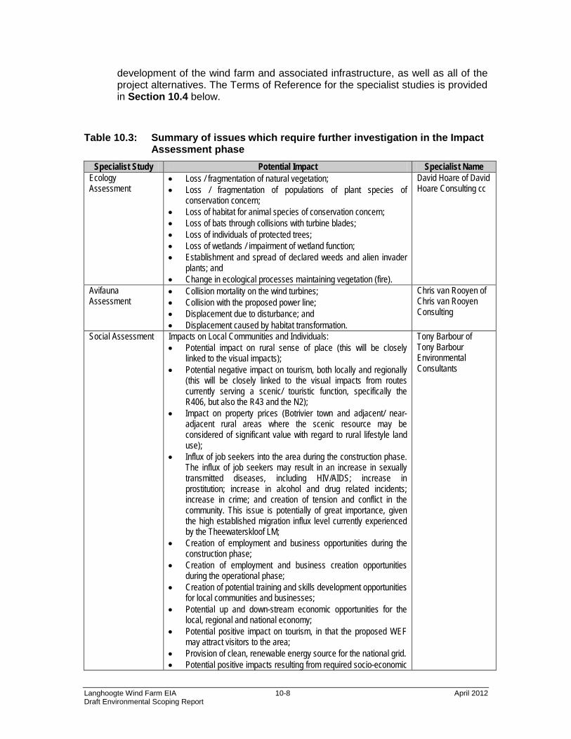
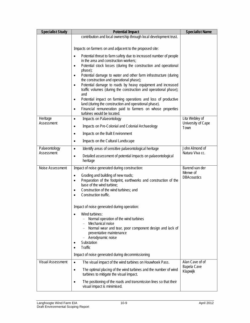
Based on the findings of the Scoping phase, the issues presented in Table 10.3 below were identified as requiring further investigation within the Impact Assessment phase. The specialists involved in the EIA are also reflected in Table 10.3. These specialist studies will consider the site proposed for the
development of the wind farm and associated infrastructure, as well as all of the project alternatives. The Terms of Reference for the specialist studies is provided in Section 10.4 below.
Table 10.3: Summary of issues which require further investigation in the Impact Assessment phase
Specialist Study Potential Impact Specialist Name Ecology Assessment
• Loss / fragmentation of natural vegetation; • Loss / fragmentation of populations of plant species of
conservation concern; • Loss of habitat for animal species of conservation concern; • Loss of bats through collisions with turbine blades; • Loss of individuals of protected trees; • Loss of wetlands / impairment of wetland function; • Establishment and spread of declared weeds and alien invader
plants; and • Change in ecological processes maintaining vegetation (fire).
David Hoare of David Hoare Consulting cc
Avifauna Assessment
• Collision mortality on the wind turbines; • Collision with the proposed power line; • Displacement due to disturbance; and • Displacement caused by habitat transformation.
Chris van Rooyen of Chris van Rooyen Consulting
Social Assessment Impacts on Local Communities and Individuals: • Potential impact on rural sense of place (this will be closely
linked to the visual impacts); • Potential negative impact on tourism, both locally and regionally
(this will be closely linked to the visual impacts from routes currently serving a scenic/ touristic function, specifically the R406, but also the R43 and the N2);
• Impact on property prices (Botrivier town and adjacent/ near-adjacent rural areas where the scenic resource may be considered of significant value with regard to rural lifestyle land use);
• Influx of job seekers into the area during the construction phase. The influx of job seekers may result in an increase in sexually transmitted diseases, including HIV/AIDS; increase in prostitution; increase in alcohol and drug related incidents; increase in crime; and creation of tension and conflict in the community. This issue is potentially of great importance, given the high established migration influx level currently experienced by the Theewaterskloof LM;
• Creation of employment and business opportunities during the construction phase;
• Creation of employment and business creation opportunities during the operational phase;
• Creation of potential training and skills development opportunities for local communities and businesses;
• Potential up and down-stream economic opportunities for the local, regional and national economy;
• Potential positive impact on tourism, in that the proposed WEF may attract visitors to the area;
• Provision of clean, renewable energy source for the national grid. • Potential positive impacts resulting from required socio-economic
Tony Barbour of Tony Barbour Environmental Consultants
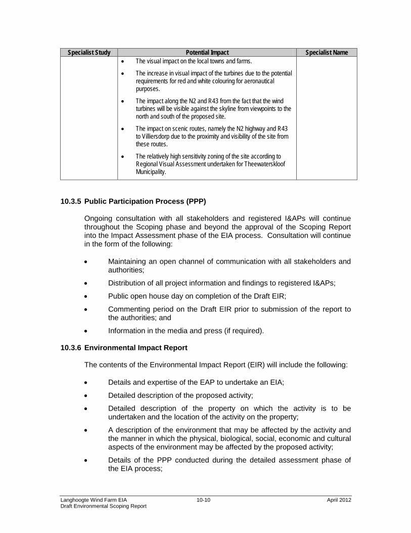
Specialist Study Potential Impact Specialist Name • The visual impact on the local towns and farms.
• The increase in visual impact of the turbines due to the potential requirements for red and white colouring for aeronautical purposes.
• The impact along the N2 and R43 from the fact that the wind turbines will be visible against the skyline from viewpoints to the north and south of the proposed site.
• The impact on scenic routes, namely the N2 highway and R43 to Villiersdorp due to the proximity and visibility of the site from these routes.
• The relatively high sensitivity zoning of the site according to Regional Visual Assessment undertaken for Theewaterskloof Municipality.
10.3.5 Public Participation Process (PPP)
Ongoing consultation with all stakeholders and registered I&APs will continue throughout the Scoping phase and beyond the approval of the Scoping Report into the Impact Assessment phase of the EIA process. Consultation will continue in the form of the following: • Maintaining an open channel of communication with all stakeholders and
authorities;
• Distribution of all project information and findings to registered I&APs;
• Public open house day on completion of the Draft EIR;
• Commenting period on the Draft EIR prior to submission of the report to the authorities; and
• Information in the media and press (if required).
10.3.6 Environmental Impact Report The contents of the Environmental Impact Report (EIR) will include the following: • Details and expertise of the EAP to undertake an EIA;
• Detailed description of the proposed activity;
• Detailed description of the property on which the activity is to be undertaken and the location of the activity on the property;
• A description of the environment that may be affected by the activity and the manner in which the physical, biological, social, economic and cultural aspects of the environment may be affected by the proposed activity;
• Details of the PPP conducted during the detailed assessment phase of the EIA process;
• A description of the need and desirability of the proposed activity
• A description of identified potential alternatives to the proposed activity, including advantages and disadvantages that the proposed activity or alternatives may have on the environment and the community that may be affected by the activity;
• An indication of the methodology used in determining the significance of potential environmental impacts;
• A description and comparative assessment of all alternatives identified during the environmental impact assessment process;
• A summary of the findings and recommendations of any specialist report or report on specialised process;
• A description of all environmental issues that were identified during the environmental impact assessment process, an assessment of the significance of each issue and an indication of the extent to which the issues could be addressed by the adoption of mitigation measures;
• An assessment of each identified potentially significant impact in terms of cumulative impacts, the nature of the impact, the extent and duration of the impact, the probability of the impact occurring, the degree to which the impact can be reversed, the degree to which the impact may cause irreplaceable loss of resources and the degree to which the impact can be mitigated;
• A description of any assumptions, uncertainties and gaps in knowledge;
• A reasoned opinion as to whether the activity should or should not be authorised, and if the opinion is that it should be authorised, any conditions that should be made in respect of that authorisation;
• An environmental impact statement which contains a summary of the key findings of the environmental impact assessment, a comparative assessment of the positive and negative implications of the proposed activity and identified alternatives;
• A draft Environmental Management Programme (EMP);
• Copies of any specialist reports and reports on specialised processes; and
• Any specific information that may be required by the competent authority and any other matters required in terms of sections 24(4)(a) and (b) of NEMA.
During the compilation of the EIA Report, a draft EMP will be compiled in accordance with the NEMA EIA Regulations. The draft EMP will provide the actions for the management of identified environmental impacts emanating from the proposed project and a detailed outline of the implementation programme to minimise and/ or eliminate the anticipated negative environmental impacts. The draft EMP will provide strategies to be used to address the roles and
responsibilities of environmental management personnel on site, and a framework for environmental compliance and monitoring. The draft EMP will be included as part of the EIR. The EMP will include the following: • Details and expertise of the person who prepared the EMP;
• Information on any proposed management or mitigation measures that will be taken to address the environmental impacts that are identified in the Environmental Impact Report (EIR), including environmental impacts or objectives in respect of planning and design, pre-construction and construction activities, operation or undertaking of the activity, rehabilitation of the environment and closure where relevant;
• A detailed description of the aspects of the activity that are covered by the draft EMP;
• An identification of the persons who will be responsible for the implementation of the measures;
• Proposed mechanisms for monitoring compliance with the EMP and reporting thereon;
• As far as reasonable practicable, measures to rehabilitate the environment affected by the undertaking of any listed activity or specified activity to its natural or predetermined state or to a land use which confirms to the generally accepted principle of sustainable development, including, where appropriate, concurrent or progressive rehabilitation measures;
• A description of the manner in which it is intended to modify, remedy, control of stop any action activity or process which causes pollution or environmental degradation; remedy the cause of pollution or degradation and migration of pollutants; comply with any prescribed environmental management standards or practices; comply with any applicable provisions of the Act regarding closure, where applicable; comply with any provisions of the Act regarding financial provisions for rehabilitation, where applicable; time periods within which the measures contemplated in the environmental management programme must be implemented; the process for managing any environmental damage, pollution, pumping and treatment of extraneous water or ecological degradation as a result of undertaking a listed activity; an environmental awareness plan describing the manner in which the applicant intends to inform his or her employees of any environmental risk which may result from their work; and the risks that must be dealt with in order to avoid pollution or the degradation of the environment; and where appropriate, closure plans, including closure objectives.
The Draft EIR will be distributed to suitable public venues with comment sheets, which will be collected at the end of the comment period. Registered I&APs will be informed of the location and contact details of the public venues. A commenting period of at least 30 days will be provided for registered I&APs to comment on the Draft EIR. Comments on the Draft EIR will be captured and responded to in the updated Issues and Response Register. A Revised Draft EIR will be compiled should the comments suggest that substantial amendments to the document will be necessary and this Revised Draft EIR will be circulated. Thereafter, the Draft EIR will be finalised into a Final EIR, which will be submitted to the DEA for their review. All registered I&APs will be informed of the availability of the Final EIA Report. Any comments received on the Final EIA Report will be submitted directly to the DEA for their review and consideration.
10.3.9 Consultation with the DEA It is envisaged that consultation with the DEA will coincide with the compilation of the following key documents: • Scoping Report and Plan of Study for EIA;
• Draft EIR and EMP; and
• Final EIR Report and EMP. Consultation outside of the above deliverables will be undertaken as necessary in order to ensure that the DEA is aware of the status of the project.
10.3.10 Proposed Project Programme for the EIA The programme for the EIA suggests the following timeframes with respect to the most important activities to be undertaken: • Submission of the Draft Scoping Report for public comment - April 2012;
• Submission of the Final Scoping Report to the DEA – May 2012;
• Submission of the Draft EIR for public comment – Sept 2012
• Submission of the Final EIR to the DEA – November 2012.
The EIA process is iterative by nature and it should therefore be appreciated that the above dates are provided as guidance only and are subject to change.
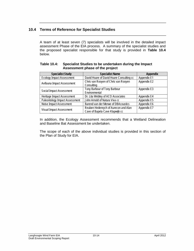
A team of at least seven (7) specialists will be involved in the detailed impact assessment Phase of the EIA process. A summary of the specialist studies and the proposed specialist responsible for that study is provided in Table 10.4 below.
Table 10.4: Specialist Studies to be undertaken during the Impact Assessment phase of the project
Specialist Study Specialist Name Appendix Ecology Impact Assessment David Hoare of David Hoare Consulting cc Appendix E1
Avifauna Impact Assessment Chris van Rooyen of Chris van Rooyen Consulting
Appendix E2
Social Impact Assessment Tony Barbour of Tony Barbour Environmental
Appendix E3
Heritage Impact Assessment Dr. Lita Webley of ACO Associates Appendix E4 Paleontology Impact Assessment John Arnold of Natura Viva cc Appendix E5 Noise Impact Assessment Barend van der Merwe of DBAcoustics Appendix E6
Visual Impact Assessment Reuben Hedenrych of Aurecon and Alan Cave of Bapela Cave Klapwijk cc
Appendix E7
In addition, the Ecology Assessment recommends that a Wetland Delineation and Baseline Bat Assessment be undertaken. The scope of each of the above individual studies is provided in this section of the Plan of Study for EIA.
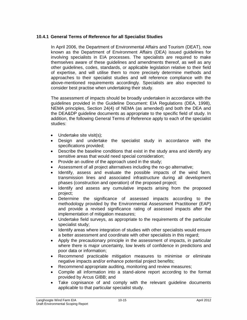
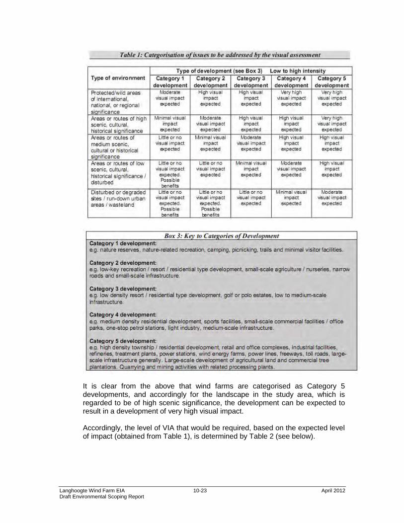
10.4.1 General Terms of Reference for all Specialist Studies
In April 2006, the Department of Environmental Affairs and Tourism (DEAT), now known as the Department of Environment Affairs (DEA) issued guidelines for involving specialists in EIA processes. The specialists are required to make themselves aware of these guidelines and amendments thereof, as well as any other guidelines, codes, standards, or applicable legislation relative to their field of expertise, and will utilise them to more precisely determine methods and approaches to their specialist studies and will reference compliance with the above-mentioned requirements accordingly. Specialists are also expected to consider best practise when undertaking their study. The assessment of impacts should be broadly undertaken in accordance with the guidelines provided in the Guideline Document: EIA Regulations (DEA, 1998), NEMA principles, Section 24(4) of NEMA (as amended) and both the DEA and the DEA&DP guideline documents as appropriate to the specific field of study. In addition, the following General Terms of Reference apply to each of the specialist studies:
• Undertake site visit(s); • Design and undertake the specialist study in accordance with the
specifications provided; • Describe the baseline conditions that exist in the study area and identify any
sensitive areas that would need special consideration; • Provide an outline of the approach used in the study; • Assessment of all project alternatives including the no-go alternative; • Identify, assess and evaluate the possible impacts of the wind farm,
transmission lines and associated infrastructure during all development phases (construction and operation) of the proposed project;
• Identify and assess any cumulative impacts arising from the proposed project;
• Determine the significance of assessed impacts according to the methodology provided by the Environmental Assessment Practitioner (EAP) and provide a revised significance rating of assessed impacts after the implementation of mitigation measures;
• Undertake field surveys, as appropriate to the requirements of the particular specialist study;
• Identify areas where integration of studies with other specialists would ensure a better assessment and coordinate with other specialists in this regard;
• Apply the precautionary principle in the assessment of impacts, in particular where there is major uncertainty, low levels of confidence in predictions and poor data or information;
• Recommend practicable mitigation measures to minimise or eliminate negative impacts and/or enhance potential project benefits;
• Recommend appropriate auditing, monitoring and review measures; • Compile all information into a stand-alone report according to the format
provided by Arcus GIBB; and • Take cognisance of and comply with the relevant guideline documents
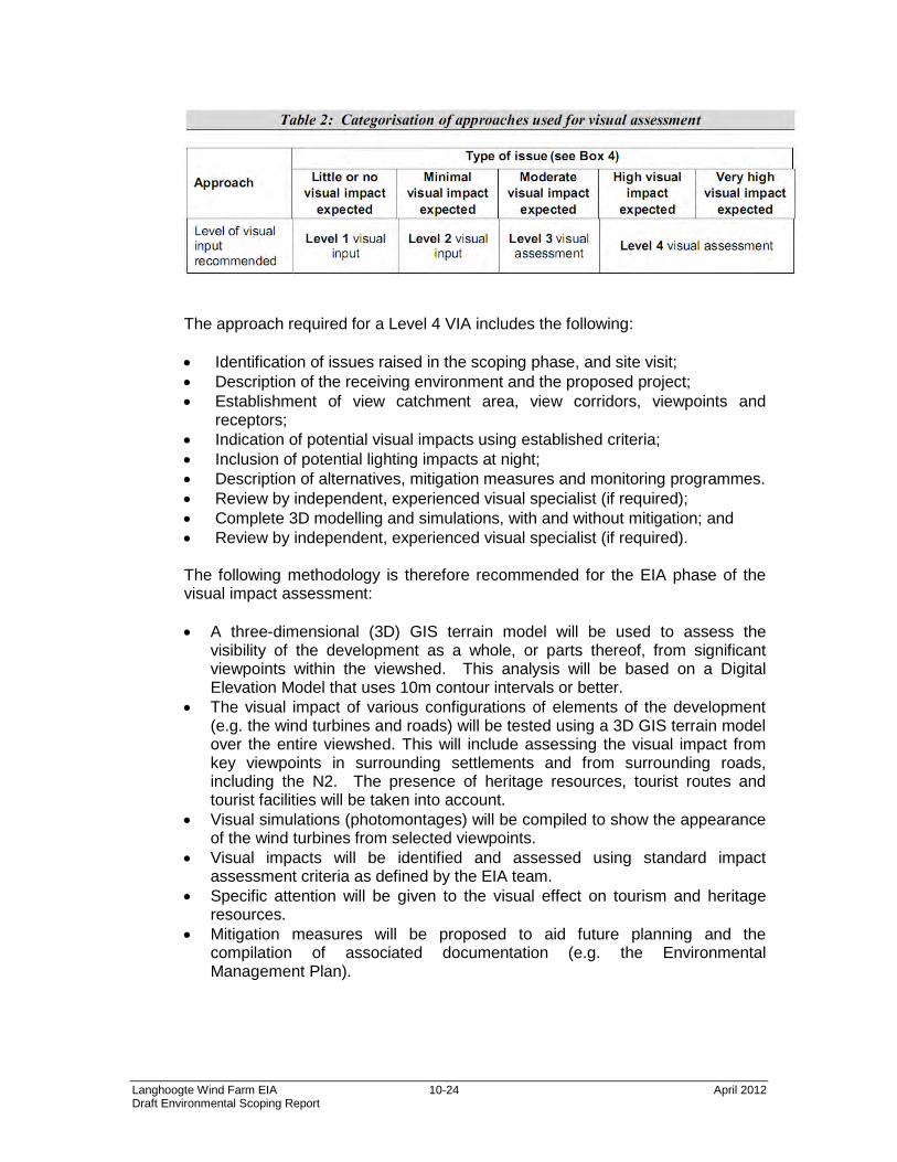
10.4.2 Specific Terms of Reference for Specialist Assessments of Potentially
Significant Issues The specific terms of reference for the following specialist studies are presented below: • Ecology Study • Avifaunal Impact Assessment • Social Impact Assessment • Heritage • Paleontology • Noise • Visual Ecology Impact Assessment
The Ecology Impact Assessment will include the following specific tasks:
Assessment of sensitive vegetation The draft sensitivity map provided in this Scoping report (Figure 4) will be verified in the field. It will be confirmed that those areas identified as being in a natural, secondary or disturbed state are so. Boundaries have already been determined by mapping from aerial photography, but the state of habitats is important to verify. In addition, natural areas will be examined in the field to provide a general indication of overall condition. Assessment of plant and animal species of concern The potential presence of species of concern will be evaluated during the EIA phase. This will be done by assessing habitat suitability for those plant and animal species of conservation concern that have been assessed as potentially occurring in the area. The lists provided in this Scoping Report will form the basis for this assessment. Particular attention will be paid to those plant and animal species classified as threatened (VU, EN or CR), Near Threatened or Critically Rare, including 287 plant species and 7 animal species. It must be noted that this assessment does not constitute a detailed search for these species, which requires separate specialist studies, if required. This would only be required if natural habitat that could potentially support such species would be directly affected by proposed infrastructure. Assessment of protected trees Searches will be undertaken in the thicket in the drainage lines to determine whether any protected trees occur on site or not.
It is also recommended that the following specialist studies be undertaken as part of the impact assessment phase:
• Wetlands It is recommended that a wetland delineation be undertaken according to the National Water Act (Act No. 36 of 1998), as described in the document: “A Practical Field Procedure for the Identification and Delineation of Wetlands and Riparian Areas” (DWAF 2005). Wetlands are defined on the basis of soil wetness parameters and are independent of whether natural habitat still occurs within these areas or not. It is important to locate and map these areas in order to (i) comply with the National Water Act and (ii) ensure that hydrological processes in the landscape are not compromised. • Bats A specialist assessment of bats impacts should be undertaken to determine whether bat species of concern occur on site or not and whether roosting habitats or known important maternity roosts occur within close proximity to the site.
Avifauna Impact Assessment The terms of reference for this Impact Assessment phase of the avifaunal study are as follows:
• Describe affected environment and determine status quo: The existing
environment will described and the bird communities most likely to be impacted will be identified. Different bird micro-habitats will be described as well as the species associated with those habitats.
• Indicate how a resource or community will be affected. Typical impacts that could be expected from the development will be listed as well as the expected impact on the bird communities. Impacts will be quantified (if possible) and a full description of predicted impacts (direct and indirect) will be provided.
• Gaps in baseline data. Gaps in baseline data will be highlighted and discussed. An indication of the confidence levels will be given. The best available data sources will be used to predict the impacts, and extensive use will be made of local knowledge.
• Assessment of impacts: The potential impact on the birds will be assessed and evaluated according to the magnitude, spatial scale, timing, duration, reversibility, probability and significance (or any other criteria required).
• Propose and explain mitigation measures. Practical mitigation measures will be recommended and discussed.
• Summarise residual impacts after mitigation. An impact summary table will be provided, discussing expected impacts before and after mitigation.
• Mapping of sensitive areas: Bird sensitive areas will be mapped in a sensitivity map for easy reference
A pre-construction monitoring programme will also be undertaken in line with the ‘Best practice guidelines for avian monitoring and impact mitigation at proposed wind energy development sites in southern Africa” Version 2. The purpose of the monitoring programme will be to provide the necessary information on bird occurrence and flight patterns to inform the final layout of the turbines. The objectives of the monitoring programme are to gather baseline data over a period of 12 months on the following aspects pertaining to avifauna:
• The abundance and diversity of birds at the wind farm site and a suitable
control site (to be determined). • Flight patterns of priority species at the wind farm site.
The methodology will be discussed on an ongoing basis with relevant NGO stakeholders as the project progresses, specifically the EWT and BLSA, at the regular meetings of the Birds and Wind Energy Specialist Group (BAWESG). The priority species will be identified through the use of the following data sources: • The latest version of the BLSA list of priority species for wind farms (2011). • Existing avifaunal data sources, e.g. the South African Bird Atlas 2 (SABAP2)
and the Co-ordinated Avifaunal Road Count (CAR). • The results of monitoring at several wind farm sites in the Overberg Bay area
which commenced in 2011 and is currently ongoing (use of this data would have to be discussed with the relevant developers).
Social Impact Assessment The approach to the Social Impact Assessment (SIA) study is based on the Western Cape Department of Environmental Affairs and Development Planning Guidelines for Social Impact Assessment. These guidelines are based on international best practice. The key activities in the SIA process embodied in the guidelines include:
• Describing and obtaining an understanding of the proposed intervention
(type, scale, location), the communities likely to be affected and determining the need and scope of the SIA;
• Collecting baseline data on the current social environment and historical social trends;
• Identifying and collecting data on the SIA variables and social change processes related to the proposed intervention. This requires consultation with affected individuals and communities;
• Assessing and documenting the significance of social impacts associated with the proposed intervention; and
• Identifying alternatives and mitigation measures. In this regard the study will include:
• Review of demographic data from the 2001 Census Survey and other
relevant sources, including local IDP documents etc; • Review of relevant planning and policy frameworks for the area, including the
Western Cape Provincial Spatial Development Framework; • Collation of site specific information during the site visits to the area; • Review of information from similar projects; • Interviews with key interested and affected parties and stakeholders; • Identification of social issues associated with the proposed project; and • Identification of potential mitigation and or enhancement measures.
The detailed public consultation process will be undertaken during the EIA phase of the project. Issues raised through this process will feed into the SIA for the proposed power lines. Heritage Impact Assessment The EIA needs to fulfil the requirements of heritage impact assessment as defined in Section 38 of the National Heritage Resources Act. The assessment will therefore have to cover the full range of potential cultural heritage as defined as “cultural” contained in the NHRA. The following assessments will therefore be undertaken: • A desktop paleontological assessment (see Paleontological section below for
further detail); • A survey by an archaeologist to determine the location of pre-colonial and
colonial archaeological remains. The significance of each find will need to be assessed along with the impacts of the proposed activity;
• Proposed routes of linear infrastructure (access roads, underground services, power lines) will need to be ground-proofed to establish the impacts of the proposed activity and determine where mitigation (if any) will be required;
• The colonial period history of the area will need to be established through archival research and the assessment and grading of the built environment both within the study area, and within a 2km radius from the boundaries. This is to determine the impact of the proposed action to the historical significance of the place;
• In terms of impacts on the cultural landscape, it is proposed that careful positioning of the turbines will be required within the study area to mitigate the visual impact. Close co-operation with the VIA specialist will be required; and
• Follow up heritage work, such as monitoring of excavations by an archaeologist and/or palaeontologist, is likely to be required in the Environmental Management Plan.
Paleontological Impact Assessment Subsequent to the findings from the Heritage Resources Study, a detailed Paleontological Study must be undertaken to assess potential impacts. The following assessments will therefore be carried out: • A desktop paleontological assessment of relevant studies in the Overberg
region; • Conduct a site visit to identify and map relevant geological units in relation to
the site; • Cross-reference the recorded fossil record of each geological unit that is
mapped within the study area, together with an indication of its overall sensitivity to development.
Noise Impact Assessment
It is proposed to make use of the following six-stage process approach to assessment and mitigation: • Step1- Define the project requirements and noise problem – gather technical
support information; • Step 2 – Agree on the assessment criteria, establish the baseline noise
environment and determine the extent of the noise impact of the initial proposal;
• Step 3 – Identify and agree on noise mitigation options; • Step 4 – Assess noise impact against criteria of Step 2 and evaluate key
considerations and significance for each mitigation option; • Step 5 – Determine the optimal noise control solution; and • Step 6 – Review, implement, monitor and audit.
The following methodology will be employed for the noise impact assessment undertaken in the Impact Assessment phase: • Determine the prevailing ambient noise level at each of the above measuring
points by means of the recommended noise measuring procedure in SANS 10103 of 2008;
• Calculate or determine the acceptable rating level for each measuring point; • Calculate, determine and/or research the projected noise level of each noise
source that is part of the construction, operational, maintenance and the decommissioning phases of the project;
• Calculate the noise impact at each of the noise sensitive areas; • Assess the proposed project in terms of the SANS 10103 of 2008, SANS
10328 of 2008, Western Cape Noise Control Regulations, Environmental Health and Safety Guidelines for Wind energy by the World Bank, World Health Organizations Health Guidelines and any other International Guidelines on wind energy;
• Evaluate all possible noise mitigation measures to reduce, minimize or eliminate the alleged noise intrusion; and
• Evaluate the field study noise data and available noise data on the wind turbines and compile the noise impact assessment report for the EIA process.
In line with the above, a noise study of the proposed site and abutting noise sensitive areas will firstly be undertaken in order to determine the existing noise regime. A noise survey will be undertaken as detailed below. The noise survey will be conducted in terms of the provisions of SANS 10103 of 2008 “The measurement and rating of environmental noise with respect to annoyance and to speech communication” and the Western Cape Noise Control Regulations.
Instruments The instruments that will be used in the noise survey include the following: • Instrument 1
Larsen Davis Integrated Sound Level meter Type 1 Larsen Davis Pre-amplifier Larsen Davis ½” free field microphone Larsen Davis Calibrator 200
• Instrument 2
Larsen Davis Integrated Sound Level meter Type 1 Larsen Davis Pre-amplifier Larsen Davis ½” free field microphone Larsen Davis Calibrator 200
Measuring points The measuring points for the Caledon wind farm area will be at the farm houses within the site and at the individual farm houses abutting the wind farm area. Measuring points will also be identified at Caledon and Botrivier. The locations of these points will be determined after undertaking a field assessment of the area. Site Characteristics Topography, ground conditions, vertical structures and ground cover will be recorded for each measuring point. The study area is agricultural land with an undulated type landscape towards the south. Current noise sources
The desk study undertaken revealed that traffic noise, wind noise, domestic type noise and farming activity noise are the main contributors to the
prevailing ambient noise level of the different areas. The prevailing noise level is proportional to the distance from the main noise sources.
Atmospheric conditions
The wind speed, temperature, humidity and wind direction will be determined at each measuring position. Information will also be obtained from the static weather station. Duration of noise readings
The day and night time noise measurements will be in line with the recommendations of SANS 10103 of 2008 and the Noise Control Regulations. It is required to take a noise level reading of at least 10-minutes per measuring point.
As noted previously, there is valuable information regarding noise from wind turbines already in use by other countries that will be used in this noise impact study to determine the wind generated by the proposed wind turbines. Some research has also been done on long time measurements of noise from wind turbines; location and quantification of noise sources; impact on noise annoyance amongst people living in the vicinity of wind turbines; and wind profile on wind turbine sound. These studies were published in the Journal of Sound and Vibration 2004 and 2007 and will be used in this noise study. This information will be used to evaluate the noise impact on the environment and the abutting noise sensitive areas. Visual Impact Assessment The Terms of Reference for the visual impact assessment phase are based on the findings of the site visit, as well as interpretation of the guideline document for VIAs (Oberholzer 20052) commissioned by the Western Cape Department of Environmental Affairs and Development Planning (DEA&DP). In terms of this guideline document, the depth and scope of a VIA is based on a combination of the sensitivity of the environment and the nature of the existing environment. The type of environment and type of development and both divided into five categories, which are indicated in a matrix (Table 1 from Oberholzer 2005). The category of development is based on Box 3 from the same document (see below).
It is clear from the above that wind farms are categorised as Category 5 developments, and accordingly for the landscape in the study area, which is regarded to be of high scenic significance, the development can be expected to result in a development of very high visual impact. Accordingly, the level of VIA that would be required, based on the expected level of impact (obtained from Table 1), is determined by Table 2 (see below).
The approach required for a Level 4 VIA includes the following: • Identification of issues raised in the scoping phase, and site visit; • Description of the receiving environment and the proposed project; • Establishment of view catchment area, view corridors, viewpoints and
receptors; • Indication of potential visual impacts using established criteria; • Inclusion of potential lighting impacts at night; • Description of alternatives, mitigation measures and monitoring programmes. • Review by independent, experienced visual specialist (if required); • Complete 3D modelling and simulations, with and without mitigation; and • Review by independent, experienced visual specialist (if required). The following methodology is therefore recommended for the EIA phase of the visual impact assessment: • A three-dimensional (3D) GIS terrain model will be used to assess the
visibility of the development as a whole, or parts thereof, from significant viewpoints within the viewshed. This analysis will be based on a Digital Elevation Model that uses 10m contour intervals or better.
• The visual impact of various configurations of elements of the development (e.g. the wind turbines and roads) will be tested using a 3D GIS terrain model over the entire viewshed. This will include assessing the visual impact from key viewpoints in surrounding settlements and from surrounding roads, including the N2. The presence of heritage resources, tourist routes and tourist facilities will be taken into account.
• Visual simulations (photomontages) will be compiled to show the appearance of the wind turbines from selected viewpoints.
• Visual impacts will be identified and assessed using standard impact assessment criteria as defined by the EIA team.
• Specific attention will be given to the visual effect on tourism and heritage resources.
• Mitigation measures will be proposed to aid future planning and the compilation of associated documentation (e.g. the Environmental Management Plan).
10.4.3 Potential issues not requiring further specialist assessments (a) Traffic Potential traffic and transport impacts are identified in Chapter 8. The greatest potential impact will therefore arise during the delivery of the wind turbines and construction materials. As described in Chapter 3, it has been estimated that in total, each turbine will require 16 loads / trips. Turbines will be transported from Cape Town or Saldanha harbours. The turbine components will be transported as abnormal loads. To minimize the potential impact of traffic delays, these loads should avoid roads and intersections with high traffic volumes. A transport of loads application will need to be submitted to the provincial government by the haulier in order to transport the abnormal loads. Construction and foundation materials will be transported from nearby Quarries & Suppliers in Villiersdorp and Botrivier respectively. Transportation will be provided for the construction staff by the Contractor. A parking area for site engineers, visitors and construction vehicles will need to be provided on the site. The impacts associated with construction will be temporary. In terms of non-motorised transport, an Obstacle Application Process may be required to assess the aviational impact of the structures and the South African Civil Aviation Authority will be required to carry out a detailed analysis of the possible impact of the development. No daily traffic is expected to be generated during the operational phase of the Langhoogte Wind Farm because the operation will be monitored remotely. Routine maintenance activities that are undertaken at the site will give rise to negligible traffic generation. The decommissioning phase of the proposed wind farm is anticipated to have similar impact on the transportation network as the construction phase, therefore the same issues as the construction phase will apply to the decommissioning phase. Any impacts will be temporary. No specialist transport assessment is therefore required for the Impact Assessment phase.
(b) Agriculture The anticipated impacts on agriculture and likely to be of low significance with the implementation of the proposed mitigation. The specialist agricultural study undertaken for the Scoping phase is considered sufficient for the purposes of the EIA process.
This Plan of Study for EIA is aimed at meeting the requirements of the EIA Regulations as a minimum. The methodologies proposed for obtaining the information required to effectively identify and assess the potential environmental impacts of the project are considered to be comprehensive and sufficient to allow for the compilation of an Environmental Impact Assessment Report which addresses I&AP concerns and which will provide the competent authority with the appropriate information necessary to allow for informed decision-making on the application for authorisation.
1 DEAT (2005) Guideline 3: General Guide to the Environmental Impact Assessment Regulations, 2005, Integrated Environmental Management Guideline Series, Department of Environmental Affairs and Tourism (DEAT), Pretoria. 2 Oberholzer, B. (2005) Guideline for involving visual & aesthetic specialists in EIA processes: Edition 1. CSIR Report No ENV-S-C 2005 053 F. Republic of South Africa, Provincial Government of the Western Cape, Department of Environmental Affairs & Development Planning, Cape Town.
Langhoogte Wind Farm EIA April 2012 Draft Environmental Scoping Report
2-1
2 DETAILS OF ROLEPLAYERS
2.1 Introduction
This chapter of the Scoping Report provides the particulars, including contact details, of the applicant, the EIA consultant and the relevant authority. Details of the specialists appointed to undertake the relevant specialist studies are provided within the respective specialist study reports attached within the appendices.
2.2 Details of Applicant
SAGIT Energy Ventures (Pty) Ltd (“SAGIT”) is the applicant for the proposed Langhoogte Wind Farm development. The details of the applicant are shown in the table below. Table 2.1: Details of the applicant
Name of Applicant: SAGIT Energy Ventures (Pty) Ltd
2.3 Details of Independent Environmental Assessment Practitioner
Arcus GIBB (Pty) Ltd. (Arcus GIBB) is an integrated group of scientists, project managers and engineers providing cost-effective solutions and specialist services in a wide range of disciplines. The multi-disciplinary consulting, management and design approach allows for the execution of projects in a holistic way, as this is believed to be the best approach to fully meet the needs of our clients. Specific to environmental management, Arcus GIBB has a team of specialists comprising environmental scientists, environmental engineers, geologists and geo-hydrologists that form the national Environmental Team. These specialists have broad experience in terms of working on a range of environmental projects within the public and private sector. The Environmental Services Division has a formidable track record and comprises highly qualified and experienced technical staff. Curriculum Vitae (CV) of the team are presented in Appendix C.
Langhoogte Wind Farm EIA April 2012 Draft Environmental Scoping Report
2-2
Table 2.2: Details of the Independent Environmental Assessment Practitioner (EAP)
Name of Consultant: Arcus GIBB (Pty) Ltd
Contact person: Mr Walter Fyvie
Postal Address: PO Box 63703, Port Elizabeth, 6057
Mr. Walter Fyvie - MSc (Environmental Biotechnology); PrSciNat; is a Professional Environmental Scientist. He is a Senior Environmental Scientist at Arcus GIBB with 10 years experience in the environmental field, having been the Project Leader on a number of environmental projects including EIAs both in South Africa and the UK. Walter specialises in Environmental Impact Assessments, Environmental Management Plans, environmental auditing, and waste management.
2.4 Details of Competent / Relevant Authority
The Department of Environmental Affairs (DEA) will act as the competent authority and the Western Cape Department of Environmental Affairs and Development Planning (DEA&DP) as the commenting authority for this application. The mandate and core business of the DEA is underpinned by the Constitution and all other relevant legislation and policies applicable to the government of the Republic of South Africa. Table 2.3: Details of the relevant competent authority
Name: Department of Environmental Affairs
Case Officer: Ms Nyiko Nkosi (Environmental Officer, Environmental Impact Evaluation)
Langhoogte Wind Farm EIA April 2012 Draft Environmental Scoping Report
3-1
3 PROJECT DESCRIPTION
3.1 Introduction
SAGIT has secured approximately 4,072 hectares (40.72 km2) between Botrivier and Caledon in the Western Cape Province, and proposes to construct and operate a wind farm and associated infrastructure to generate between 45 and 110 MW of electricity for the national grid. This chapter describes the project in sufficient detail to allow an evaluation of the potential impacts that could result from project construction and operation, and to allow development of appropriate mitigation measures for such impacts. The potential impacts associated with the project are being evaluated within the environmental studies and are discussed in Chapter 8.
3.2 Wind Energy: How it Works
Wind power is the conversion of wind energy into a useful form of energy, such as electricity, using modern and highly reliable wind turbines. Wind power is non-dispatchable, meaning that for economic operation, all of the available output must be taken when it is available. Wind Turbines, like windmills currently utilised on farms across South Africa, are mounted on a tower to capture wind energy. The kinetic energy of the wind is used to turn the blades of the turbine to generate electricity. At 30 m or more above ground they can take advantage of the faster, less turbulent wind. Usually, 2 - 3 blades are mounted on a shaft to form a rotor. The nacelle, which sits at the top of the hub, contains the generator, control equipment, gearbox and anemometer for monitoring the wind speed and direction. The mechanical power generated by the rotation of the blades is transmitted to the generator within the nacelle via a gearbox and drive train. The generator converts the turning motion of the blades into electricity. The wind turbine consists of the following major components, as shown in Figure 3.1 below: • The rotor / blades; • The nacelle / generator; • The tower; and • The foundation unit. Turbines are able to operate at varying wind speeds, dependant on site specific characteristics. The amount of energy a turbine can harness depends on both the wind velocity and the length of the rotor blades. It is anticipated that the turbines utilised for the Langhoogte Wind Farm will have a hub height of 80 - 110 m and a turbine blade length 40 - 60 m, with a generating capacity of between 2.5 MW and 3.6 MW each. Wind turbines typically start generating electricity at wind speeds of between 10 km/hr to 15 km/hr (2,5 m/s to 4 m/s). This is called the cut-in speed, the minimum wind speed at which the wind turbine will generate usable power. Nominal wind speeds required for full power operation vary between 45 km/hr and 60 km/hr (11 m/s to 15 m/s) dependant on the International Energy Council (IEC) wind Classes. At very high speeds, typically over 100 km/hr, the wind turbine will cease power generation and stop. The wind speed at which shut down occurs is called the
Langhoogte Wind Farm EIA April 2012 Draft Environmental Scoping Report
3-2
cut-out speed. This is a safety feature that protects the turbine from damage. Normal wind turbine operation usually resumes when the wind drops back to a safe level. A turbine is designed to operate continuously, and with low maintenance, for more than 20 years. Once operating, a wind energy facility can be monitored and controlled remotely, with a mobile team for maintenance when required.
Figure 3.1: Components of a typical wind turbine.
3.3 Infrastructure Requirements
SAGIT is in the process of finalising the type of turbine to be procured and the micro-siting / placement to determine the exact positioning of the turbines. Some specifications of the final project could be somewhat different than described here. However, differences are expected to be relatively minor and should not result in significantly different impacts. The proposal is for the construction, operation, and decommissioning of a wind farm comprising the following components:
• Between 20 and 50 wind turbines (including tower foundations). • Internal access roads from the R43 / N2 to the operations area. • An on-site sub-station. • Underground transmission lines to carry the electricity from the turbines to a
proposed on-site substation. • Overhead transmission line (132 kV) from the on-site substation to the existing
Eskom Sub-station located at Houhoek where the electricity will enter the grid.
Blade length: ~ 40-60m
Hub height: ~ 80–110m
Langhoogte Wind Farm EIA April 2012 Draft Environmental Scoping Report
3-3
The line will be approximately 8 – 10 km long, depending on the route option selected.
• An off-site control centre compound located in potentially in Botrivier, Caledon or inland.
As noted above, the wind farm will be integrated with the national distribution system via new transmission lines and an existing Eskom substation. Two possible routes for the new transmission lines have been proposed and are described in Section 3.4.4.
3.4 Construction Phase
The wind farm is expected to be constructed over a period of approximately 24 months and is anticipated to produce electricity for approximately 20 years or more. Construction is expected to commence in 2014. It is expected that the construction of the proposed wind farm will create a number of direct construction employment opportunities over the construction period. These workers will comprise a mixture of specialist, skilled, semi-skilled and un-skilled labour. The construction employees will be accommodated / be sourced from nearby towns (Caledon and Botrivier etc) and be transported to and from the site on a daily basis. Overnight on-site worker presence will be limited to security staff. Construction of the various components will proceed concurrently, after the access road has been laid out and begun to be built. Construction will take place predominantly in daylight hours. The construction of the approximately 10 km of 132 kV power line would take approximately 7 – 8 months. This would involve the casting of concrete plinths, the erection of the steel monopoles which are brought to the site in sections, and finally, the stringing of the line. This would involve employment opportunities for a skilled team of approximately 120 workers. A construction compound will be located on-site during the construction period. The compound will include a kitchen, fuel storage area, and a temporary warehouse to store materials and equipment. Kitchen and other wastes will be collected / recycled and transported to the nearest licensed waste site. During both construction phases, electricity will be provided from existing national grid via an 11 kV line and diesel generators. During the entire construction period, land disturbance will be kept to a minimum, and in accordance to recommendations from the EIA process. Both the access road and the on-site roads will be laid out and marked at the outset of the construction season, and passenger vehicles, trucks, and construction equipment will keep to these roads and not create new tracks. Should wet conditions cause the temporary roadways to deteriorate, gravel will be used to improve the temporary route pending completion of the permanent road, rather than having vehicles create a new track across undisturbed land.
Langhoogte Wind Farm EIA April 2012 Draft Environmental Scoping Report
3-4
The following subsections describe transportation of workers, materials, and equipment to the site, the construction compound, and the construction of the various project components.
3.4.1 Transportation The wind turbines will be transported in sections to the installation site. In addition, other materials needed for the foundations & grid-connection will be transported separately. Table 3.1: Turbine components and transportation details
Turbine Tower Section 3 per turbine on 3 Loads (Special Vehicles up to 80t)
54 tonnes to 68.4 tonnes Length: 27 m to 33 m Diameter: 5.5 m to 6.5 m
Blades (from 40m to 65m)
3 blades per turbine on 3 Loads (Special Trucks, 20t)
6.5 tonnes to 10.5 tonnes Length: 40 m to 58.5 m Radius: 3.2m
Nacelle (Generator) 1 to 3 loads per turbine depending on model
35 to 88 tonnes 5.8m x 4.7m x 3.0m
Electrical Cable & Transformers 1 x 20 ton truck Cable: 4 tonnes
Transformer: 6 tonnes
Concrete 15 to 25 Loads per foundation 305 to 500 m3: Batching on-site, with Bulk deliveries of aggregate & cement in 20 ton trucks
Re-Enforcing Steel 20 ton on 1 load Standard 20 ton truck
In total, each turbine will require 16 loads / trips, comprising of the specification and load characteristics in the column above. It is envisaged that turbines will be transported from Cape Town or Saldanha harbours in 20 to 80 ton trucks on roads connecting to the N2 Highway or via Worcester through Villiersdorp and then along the R43 Regional Road to the construction site. Construction and foundation materials will be transported from nearby quarries and suppliers in Villiersdorp and Botrivier respectively, in 20 to 50 ton trucks. Figure 3.2: Example of specialist transport for blades.
Langhoogte Wind Farm EIA April 2012 Draft Environmental Scoping Report
3-5
Figure 3.3: Example of specialist transport for manoeuvring blades and negotiating obstacles.
3.4.2 Construction Compound
Temporary works used during the construction period will consist of a temporary compound and staging area located within the site. As far as possible the construction compound will be located on already disturbed land. The main compound will include a parking area, a generator with fuel storage, and temporary buildings to provide secure storage, site offices, and welfare and first aid facilities. Above-ground tanks to store small quantities (500 - 1000 litres) of diesel fuel, 1,000 litres of hydraulic oil, and 200 litres of lubricating oil will be placed in the laydown area. An impervious surface (concrete or asphalt or other impermeable membrane) will be laid under the tank area and an earthen berm with an impermeable inner surface will be constructed around the tanks, sized so as to be able to hold all of the contents of the tanks in case of spills. In addition, a structure to hold absorbent materials for cleanup of possible spills will be placed near this storage area. The fuel tanks and spill containment area will be constructed early in the overall construction process so they can support the remainder of the construction effort as well as future operations. Any refuelling that is necessary will take place over the impervious area.
3.4.3 Access and Service Roads Access roads to the site will be via existing gravel farm roads from the N2 and R43 roads. The roads will be upgraded where required and special haul roads may need to be constructed to and within the site to accommodate abnormally loaded vehicle access and circulation. The upgrading and construction of these roads will be undertaken in advance of any components being delivered to the site and will remain in place after completion for future access and possible access for replacement parts if necessary. Internal service roads will also be constructed between the turbines and infrastructure within the proposed site for use during construction and operation. As far as possible,
Langhoogte Wind Farm EIA April 2012 Draft Environmental Scoping Report
3-6
existing roads will be utilised. The total length of these roads will vary depending on the arrangement of the turbines. The roads will be constructed with specifications, including roadway preparation, stormwater controls, and placing gravel where needed. The roads will be three to four meters wide two track roads, covered with gravel. A temporary track of approximately 13 m in width will also be required for use by the crawler crane which will be used to erect towers and turbines during construction. This track will be located adjacent to the permanent road and use part of the permanent road. The track will be removed – rehabilitated with stockpiled soil and indigenous vegetation - once the crane is no longer required (after the assembly of the turbines). Where possible, gravel taken from areas of excavation (cut) will be used to provide material where more is required (fill) and to surface the road. If additional gravel is needed, it will be transported from a nearby quarry. To the maximum extent possible, all equipment and disturbance will be confined to the roadway route itself, even before the entire road is constructed. In addition, to the extent possible, construction will take place under dry conditions. When that is not possible, appropriate methods will be used to control stormwater, measures to impede run-off and prevent erosion. Typical road construction specifications would include excavating topsoil and subsoil, grading to desired slope and grade using cut-and-fill methods, placement and compaction of gravel where needed, excavation of a drainage ditch along uphill sides where appropriate, and placement of low berms on downhill sides where necessary. Any surplus topsoil will be stockpiled and protected from erosion, for use in future reclamation. Any such areas of erosion will be stabilized for road construction, and used for future farming activities All off-road areas disturbed by construction equipment will be reclaimed by planting seeds of indigenous vegetation or feed-stock, where applicable. In addition, during the remainder of the construction season after the road is complete, and possibly the next season, indigenous vegetation will be established in any soil-based channels that are constructed alongside the road.
3.4.4 Transmission Line within the Site to the National Grid Electricity is transported along power lines from the power stations to substations located in areas where the power is required. The distances between the power stations and areas where the power is required, necessitates the transmission of electricity at high voltages to compensate for the losses that occur during transmission over long distances. The transmission of high voltages also limits the number of power lines. Transmission power lines usually consist of overhead conductors suspended from transmission towers. Overhead power lines transmit electricity at voltages ranging from 11 kV up to 765 kV. Conductors are made of aluminium, copper and steel in various combinations and in various shapes and sizes. Aluminium is used because it is a good conductor of electricity; steel is used to add strength. The electricity transmitted to substations must be reduced to a voltage that is suitable for the consumer. Transformers step-down the voltage and feed the electricity into the grid via distribution lines, which distribute the power to the end users. For this project, it is proposed that the on-site sub-station will be connected to the Houhoek sub-station via a 132 kV powerline. The proposed powerline structures will
Langhoogte Wind Farm EIA April 2012 Draft Environmental Scoping Report
3-7
likely be monopoles (21-23m high) with a three strand configuration as shown in the figure below.
Figure 3.4: Sample monopole, three strand configuration for powerline. Two possible routes have been proposed for the powerline, as shown in Figure 3.6: 1. A southern route running from the proposed internal sub-station within the
windfarm to the Houhoek Sub-station. The line runs south of Botrivier, over a total distance of approximately 8 km. Of this total length, the first approximately 3.5 km will be new line strung on new 132 kv structures on a new servitude. The line will cross the N2 motorway. The last 4.5 km will run along new structures adjacent to an existing 66 kv line (which runs from the Houhoek Sub-station to Caledon). The existing 66 kV line will remain.
2. A northern route running also from the proposed internal sub-station within the windfarm to the Houhoek Sub-station. The line runs north of Botrivier, over a total distance of approximately 9.5 km. Of this total length, the first approximately 5 km will be new line strung on new 132 kV structures on a new servitude. The line will have to cross an existing 400 kV transmission line. Similar to the southern line, the last 4.5 km will run on new structures adjacent to an existing 66 kV line (Houhoek sub-station to Villiersdorp). Similarly, here the existing 66 kV structures and line will remain.
Langhoogte Wind Farm EIA April 2012 Draft Environmental Scoping Report
3-8
Figure 3.5: Two possible routes for powerline (northern option and southern option)
Northern option: Proposed new northern 132kv powerline runs on new servitude. No existing lines in close proximity. Northern option: This
section of the line runs next to an existing 66kv line. Existing line to remain.
Southern option: Proposed new southern 132kv powerline runs on new servitude. No existing lines in close proximity.
Southern option: This section of the line runs next to an existing 66kv line. Existing line to remain.
On-site Sub-station
Houhoek Sub-station
Langhoogte Wind Farm EIA April 2012 Draft Environmental Scoping Report
3-9
3.4.5 Turbines The foundations for the turbines will be constructed first. Figure 3.6 below shows the dimensions of the typical foundation. This figure illustrates that the bulk of the foundation will be below ground level and out of sight with a pedestal of approximately 5.5 m diameter protruding above ground level. The proposed project would place the turbines, as far as possible, on hilltops within the proposed area. This is to allow for maximum exposure to wind resources. Chapter 7 provides a detailed description of the baseline environment in which the wind farm is proposed to be constructed. Turbines will be placed at least 7 diameters apart in a downwind direction and 3.5 diameter distance in a crosswind direction (for example, assuming a 50 m blade length, the turbines will be located 700m apart in a downwind direction and 350m apart in a crosswind direction). Optional layouts with regards to the placement of wind turbines will be determined from the micro-siting and the EIA process being undertaken. The findings of the environmental studies being undertaken will also provide a synopsis of opportunities and limitations for considerations in the determination of the most appropriate sites and layout options to be implemented. Project alternatives are discussed further in Chapter 4 of this document.
Figure 3.6: Foundation dimensions
Construction would involve excavating to a depth of approximately 3 m, then using steel, gravel and concrete to construct the foundations. Before each foundation is excavated, topsoil and subsoil will be salvaged and stored nearby. The topsoil will be stripped and stockpiled separately and protected from wind and water erosion. Following foundation construction, soil will be backfilled in the same stratigraphic sequence and indigenous vegetation will be re-established, except for the access roads and a small parking area at the base of the tower. As part of the foundation,
Langhoogte Wind Farm EIA April 2012 Draft Environmental Scoping Report
3-10
underground electrical lines will connect the turbines to the proposed on-site substation. Once the roads and foundations have been constructed, the wind-generating equipment will be installed. Typically, a self-propelled “crawler” crane is transported to a site by truck and assembled at the first turbine location. The tower is placed on the foundation, then the nacelle, hub, and rotors are lifted and placed. Figures 3.7 – 3.9 show turbines under construction. Error! Reference source not found.10 shows a crane lifting a rotor blade at a tower. Following installation of the turbines, any disturbed areas outside the roadway and small parking area will be reclaimed and re-vegetated with feed-stock.
Figure 3.7: Side view of turbines ready for erection.
Figure 3.8: Top view of turbines ready for erection.
Langhoogte Wind Farm EIA April 2012 Draft Environmental Scoping Report
3-11
Figure 3.9: Distant view of turbines during erection.
3.4.6 Use of Services and Resources during Construction The following services or resources will be required during construction: Water Water will be required for potable use and in the construction of the foundations for the towers. Water will be piped in from a municipal source through a temporary water pipeline. Applicable authorisation and usage licenses from relevant water authorities will be applied for. Sewage A small to negligible amount of sewage will be generated duration of the construction period. Chemical toilets will be utilised and the toilets will be serviced periodically by the supplier. Roads Existing informal roads will be used / upgraded as far as possible during construction. The use of the roads will be negotiated with the landowners. New roads will be constructed where necessary. Stormwater Stormwater will be managed in accordance with the Environmental Management Plan (EMP) that will be compiled for the construction phase. A stormwater management plan will be drafted in consultation with the relevant specialists.
Langhoogte Wind Farm EIA April 2012 Draft Environmental Scoping Report
3-12
Solid waste disposal All solid waste will be collected at a central location at each construction site and will be stored temporarily until removal to an appropriately permitted landfill site in the vicinity of the construction site. Electricity Diesel generators will predominantly be utilised for the provision of electricity during construction.
3.5 Operational Phase
The wind farm is proposed to begin generating electricity in 2016 following installation and testing of the turbines. Operational efficiency will be monitored 24 hours per day from an off-site location. In general, there will be no daily traffic to and from the site. It is anticipated that technicians will visit each turbine on at least a quarterly basis for routine inspection and maintenance. In addition, turbines will require other periodic maintenance as prescribed and performed by the equipment manufacturer, including changes of lubricating oils if applicable to the specific turbine technology used. Routine road maintenance will include blading and smoothing as necessary to maintain the road surface, as well as inspecting and repairing stormwater controls as necessary to ensure their proper functioning to control erosion. When operating, there will be some noise from each of the turbines. Noise will be generated by the gearbox (depending on the specific turbine technology used) and generator in the nacelle, and by the rotors passing through the air. The former will be largely contained by insulation, and reduced further at ground level. Rotor noise will depend on the speed of the wind and rotors. Further details are provided in the Specialist Noise Scoping Report included in the appendices. In general, land disturbance will be confined to areas on and around where various site components were constructed, with no additional disturbance of otherwise undisturbed lands.
3.6 Decommissioning Phase
At present, it is not possible to describe the activities at the end of the operational life of the wind farm. It is possible that SAGIT will replace turbines, extend the period of the lease, and continue to generate electricity, in which case decommissioning may be postponed for years or decades. When electricity generation finally ends, the proponent may wish to leave at least some of the roads and/or transmission lines in place. Regardless, activities would have to be in compliance with national and local government requirements. The current government Renewable IPP (Independent Power Producer) procurement process prescribes that approved projects must plan for a 20-year period of operation and must include decommissioning as part of their financial models after the 20-year period.
Langhoogte Wind Farm EIA April 2012 Draft Environmental Scoping Report
3-13
When the site is ready to be decommissioned, the turbines will be dismantled. Steel and other materials of value should be recycled. One or more buildings may continue to be occupied, and the transmission line may continue to be used. Where not required, they will be dismantled. Inert materials that cannot be re-used or recycled should be taken to a suitable landfill. Any contaminated material such as oil storage tanks should be taken to a suitable disposal site. On-site roads that will no longer be used will be reclaimed and vegetated with indigenous vegetation. Foundations and other belowground inert structures will be buried and covered with soil. Land no longer being used will be revegetated with indigenous vegetation. All these reclaimed areas will be monitored and maintained until no further attention is required to ensure long-term survival of vegetation.
3.7 Conclusion This chapter describes the various infrastructure and technology requirements for the proposed Langhoogte Wind Farm, its associated infrastructure and transmission lines in the Botrivier / Caledon area of the Western Cape Province. The wind farm is proposed to generate between 45 - 110 MW. Between 20 to 50 wind turbines, between 2.5 – 3.6 MW each in generating capacity, will be constructed within approximately 4,072 ha area. The arrangement of the wind turbines will depend predominantly on technical requirements, and on the topography and their relative orientation to the prevailing wind direction. Overhead transmission lines will connect the wind turbines to an on-site sub-station and will further be connected to the existing Houhoek Sub-station south of Botrivier. The findings of the environmental studies being undertaken will also provide a synopsis of opportunities and limitations for considerations in the determination of the most appropriate sites and layout options to be implemented.
Langhoogte Wind Farm EIA April 2012 Draft Environmental Scoping Report
3-1
3 PROJECT DESCRIPTION
3.1 Introduction
SAGIT has secured approximately 4,072 hectares (40.72 km2) between Botrivier and Caledon in the Western Cape Province, and proposes to construct and operate a wind farm and associated infrastructure to generate between 45 and 110 MW of electricity for the national grid. This chapter describes the project in sufficient detail to allow an evaluation of the potential impacts that could result from project construction and operation, and to allow development of appropriate mitigation measures for such impacts. The potential impacts associated with the project are being evaluated within the environmental studies and are discussed in Chapter 8.
3.2 Wind Energy: How it Works
Wind power is the conversion of wind energy into a useful form of energy, such as electricity, using modern and highly reliable wind turbines. Wind power is non-dispatchable, meaning that for economic operation, all of the available output must be taken when it is available. Wind Turbines, like windmills currently utilised on farms across South Africa, are mounted on a tower to capture wind energy. The kinetic energy of the wind is used to turn the blades of the turbine to generate electricity. At 30 m or more above ground they can take advantage of the faster, less turbulent wind. Usually, 2 - 3 blades are mounted on a shaft to form a rotor. The nacelle, which sits at the top of the hub, contains the generator, control equipment, gearbox and anemometer for monitoring the wind speed and direction. The mechanical power generated by the rotation of the blades is transmitted to the generator within the nacelle via a gearbox and drive train. The generator converts the turning motion of the blades into electricity. The wind turbine consists of the following major components, as shown in Figure 3.1 below: • The rotor / blades; • The nacelle / generator; • The tower; and • The foundation unit. Turbines are able to operate at varying wind speeds, dependant on site specific characteristics. The amount of energy a turbine can harness depends on both the wind velocity and the length of the rotor blades. It is anticipated that the turbines utilised for the Langhoogte Wind Farm will have a hub height of 80 - 110 m and a turbine blade length 40 - 60 m, with a generating capacity of between 2.5 MW and 3.6 MW each. Wind turbines typically start generating electricity at wind speeds of between 10 km/hr to 15 km/hr (2,5 m/s to 4 m/s). This is called the cut-in speed, the minimum wind speed at which the wind turbine will generate usable power. Nominal wind speeds required for full power operation vary between 45 km/hr and 60 km/hr (11 m/s to 15 m/s) dependant on the International Energy Council (IEC) wind Classes. At very high speeds, typically over 100 km/hr, the wind turbine will cease power generation and stop. The wind speed at which shut down occurs is called the
Langhoogte Wind Farm EIA April 2012 Draft Environmental Scoping Report
3-2
cut-out speed. This is a safety feature that protects the turbine from damage. Normal wind turbine operation usually resumes when the wind drops back to a safe level. A turbine is designed to operate continuously, and with low maintenance, for more than 20 years. Once operating, a wind energy facility can be monitored and controlled remotely, with a mobile team for maintenance when required.
Figure 3.1: Components of a typical wind turbine.
3.3 Infrastructure Requirements
SAGIT is in the process of finalising the type of turbine to be procured and the micro-siting / placement to determine the exact positioning of the turbines. Some specifications of the final project could be somewhat different than described here. However, differences are expected to be relatively minor and should not result in significantly different impacts. The proposal is for the construction, operation, and decommissioning of a wind farm comprising the following components:
• Between 20 and 50 wind turbines (including tower foundations). • Internal access roads from the R43 / N2 to the operations area. • An on-site sub-station. • Underground transmission lines to carry the electricity from the turbines to a
proposed on-site substation. • Overhead transmission line (132 kV) from the on-site substation to the existing
Eskom Sub-station located at Houhoek where the electricity will enter the grid.
Blade length: ~ 40-60m
Hub height: ~ 80–110m
Langhoogte Wind Farm EIA April 2012 Draft Environmental Scoping Report
3-3
The line will be approximately 8 – 10 km long, depending on the route option selected.
• An off-site control centre compound located in potentially in Botrivier, Caledon or inland.
As noted above, the wind farm will be integrated with the national distribution system via new transmission lines and an existing Eskom substation. Two possible routes for the new transmission lines have been proposed and are described in Section 3.4.4.
3.4 Construction Phase
The wind farm is expected to be constructed over a period of approximately 24 months and is anticipated to produce electricity for approximately 20 years or more. Construction is expected to commence in 2014. It is expected that the construction of the proposed wind farm will create a number of direct construction employment opportunities over the construction period. These workers will comprise a mixture of specialist, skilled, semi-skilled and un-skilled labour. The construction employees will be accommodated / be sourced from nearby towns (Caledon and Botrivier etc) and be transported to and from the site on a daily basis. Overnight on-site worker presence will be limited to security staff. Construction of the various components will proceed concurrently, after the access road has been laid out and begun to be built. Construction will take place predominantly in daylight hours. The construction of the approximately 10 km of 132 kV power line would take approximately 7 – 8 months. This would involve the casting of concrete plinths, the erection of the steel monopoles which are brought to the site in sections, and finally, the stringing of the line. This would involve employment opportunities for a skilled team of approximately 120 workers. A construction compound will be located on-site during the construction period. The compound will include a kitchen, fuel storage area, and a temporary warehouse to store materials and equipment. Kitchen and other wastes will be collected / recycled and transported to the nearest licensed waste site. During both construction phases, electricity will be provided from existing national grid via an 11 kV line and diesel generators. During the entire construction period, land disturbance will be kept to a minimum, and in accordance to recommendations from the EIA process. Both the access road and the on-site roads will be laid out and marked at the outset of the construction season, and passenger vehicles, trucks, and construction equipment will keep to these roads and not create new tracks. Should wet conditions cause the temporary roadways to deteriorate, gravel will be used to improve the temporary route pending completion of the permanent road, rather than having vehicles create a new track across undisturbed land.
Langhoogte Wind Farm EIA April 2012 Draft Environmental Scoping Report
3-4
The following subsections describe transportation of workers, materials, and equipment to the site, the construction compound, and the construction of the various project components.
3.4.1 Transportation The wind turbines will be transported in sections to the installation site. In addition, other materials needed for the foundations & grid-connection will be transported separately. Table 3.1: Turbine components and transportation details
Turbine Tower Section 3 per turbine on 3 Loads (Special Vehicles up to 80t)
54 tonnes to 68.4 tonnes Length: 27 m to 33 m Diameter: 5.5 m to 6.5 m
Blades (from 40m to 65m)
3 blades per turbine on 3 Loads (Special Trucks, 20t)
6.5 tonnes to 10.5 tonnes Length: 40 m to 58.5 m Radius: 3.2m
Nacelle (Generator) 1 to 3 loads per turbine depending on model
35 to 88 tonnes 5.8m x 4.7m x 3.0m
Electrical Cable & Transformers 1 x 20 ton truck Cable: 4 tonnes
Transformer: 6 tonnes
Concrete 15 to 25 Loads per foundation 305 to 500 m3: Batching on-site, with Bulk deliveries of aggregate & cement in 20 ton trucks
Re-Enforcing Steel 20 ton on 1 load Standard 20 ton truck
In total, each turbine will require 16 loads / trips, comprising of the specification and load characteristics in the column above. It is envisaged that turbines will be transported from Cape Town or Saldanha harbours in 20 to 80 ton trucks on roads connecting to the N2 Highway or via Worcester through Villiersdorp and then along the R43 Regional Road to the construction site. Construction and foundation materials will be transported from nearby quarries and suppliers in Villiersdorp and Botrivier respectively, in 20 to 50 ton trucks. Figure 3.2: Example of specialist transport for blades.
Langhoogte Wind Farm EIA April 2012 Draft Environmental Scoping Report
3-5
Figure 3.3: Example of specialist transport for manoeuvring blades and negotiating obstacles.
3.4.2 Construction Compound
Temporary works used during the construction period will consist of a temporary compound and staging area located within the site. As far as possible the construction compound will be located on already disturbed land. The main compound will include a parking area, a generator with fuel storage, and temporary buildings to provide secure storage, site offices, and welfare and first aid facilities. Above-ground tanks to store small quantities (500 - 1000 litres) of diesel fuel, 1,000 litres of hydraulic oil, and 200 litres of lubricating oil will be placed in the laydown area. An impervious surface (concrete or asphalt or other impermeable membrane) will be laid under the tank area and an earthen berm with an impermeable inner surface will be constructed around the tanks, sized so as to be able to hold all of the contents of the tanks in case of spills. In addition, a structure to hold absorbent materials for cleanup of possible spills will be placed near this storage area. The fuel tanks and spill containment area will be constructed early in the overall construction process so they can support the remainder of the construction effort as well as future operations. Any refuelling that is necessary will take place over the impervious area.
3.4.3 Access and Service Roads Access roads to the site will be via existing gravel farm roads from the N2 and R43 roads. The roads will be upgraded where required and special haul roads may need to be constructed to and within the site to accommodate abnormally loaded vehicle access and circulation. The upgrading and construction of these roads will be undertaken in advance of any components being delivered to the site and will remain in place after completion for future access and possible access for replacement parts if necessary. Internal service roads will also be constructed between the turbines and infrastructure within the proposed site for use during construction and operation. As far as possible,
Langhoogte Wind Farm EIA April 2012 Draft Environmental Scoping Report
3-6
existing roads will be utilised. The total length of these roads will vary depending on the arrangement of the turbines. The roads will be constructed with specifications, including roadway preparation, stormwater controls, and placing gravel where needed. The roads will be three to four meters wide two track roads, covered with gravel. A temporary track of approximately 13 m in width will also be required for use by the crawler crane which will be used to erect towers and turbines during construction. This track will be located adjacent to the permanent road and use part of the permanent road. The track will be removed – rehabilitated with stockpiled soil and indigenous vegetation - once the crane is no longer required (after the assembly of the turbines). Where possible, gravel taken from areas of excavation (cut) will be used to provide material where more is required (fill) and to surface the road. If additional gravel is needed, it will be transported from a nearby quarry. To the maximum extent possible, all equipment and disturbance will be confined to the roadway route itself, even before the entire road is constructed. In addition, to the extent possible, construction will take place under dry conditions. When that is not possible, appropriate methods will be used to control stormwater, measures to impede run-off and prevent erosion. Typical road construction specifications would include excavating topsoil and subsoil, grading to desired slope and grade using cut-and-fill methods, placement and compaction of gravel where needed, excavation of a drainage ditch along uphill sides where appropriate, and placement of low berms on downhill sides where necessary. Any surplus topsoil will be stockpiled and protected from erosion, for use in future reclamation. Any such areas of erosion will be stabilized for road construction, and used for future farming activities All off-road areas disturbed by construction equipment will be reclaimed by planting seeds of indigenous vegetation or feed-stock, where applicable. In addition, during the remainder of the construction season after the road is complete, and possibly the next season, indigenous vegetation will be established in any soil-based channels that are constructed alongside the road.
3.4.4 Transmission Line within the Site to the National Grid Electricity is transported along power lines from the power stations to substations located in areas where the power is required. The distances between the power stations and areas where the power is required, necessitates the transmission of electricity at high voltages to compensate for the losses that occur during transmission over long distances. The transmission of high voltages also limits the number of power lines. Transmission power lines usually consist of overhead conductors suspended from transmission towers. Overhead power lines transmit electricity at voltages ranging from 11 kV up to 765 kV. Conductors are made of aluminium, copper and steel in various combinations and in various shapes and sizes. Aluminium is used because it is a good conductor of electricity; steel is used to add strength. The electricity transmitted to substations must be reduced to a voltage that is suitable for the consumer. Transformers step-down the voltage and feed the electricity into the grid via distribution lines, which distribute the power to the end users. For this project, it is proposed that the on-site sub-station will be connected to the Houhoek sub-station via a 132 kV powerline. The proposed powerline structures will
Langhoogte Wind Farm EIA April 2012 Draft Environmental Scoping Report
3-7
likely be monopoles (21-23m high) with a three strand configuration as shown in Figure 3.4 below.
Figure 3.4: Sample monopole, three strand configuration for powerline. Two possible routes have been proposed for the powerline, as shown in Figure 3.6: 1. A southern route running from the proposed internal sub-station within the
windfarm to the Houhoek Sub-station. The line runs south of Botrivier, over a total distance of approximately 8 km. Of this total length, the first approximately 3.5 km will be new line strung on new 132 kv structures on a new servitude. The line will cross the N2 motorway. The last 4.5 km will run along new structures adjacent to an existing 66 kv line (which runs from the Houhoek Sub-station to Caledon). The existing 66 kV line will remain.
2. A northern route running also from the proposed internal sub-station within the windfarm to the Houhoek Sub-station. The line runs north of Botrivier, over a total distance of approximately 9.5 km. Of this total length, the first approximately 5 km will be new line strung on new 132 kV structures on a new servitude. The line will have to cross an existing 400 kV transmission line. Similar to the southern line, the last 4.5 km will run on new structures adjacent to an existing 66 kV line (Houhoek sub-station to Villiersdorp). Similarly, here the existing 66 kV structures and line will remain.
Langhoogte Wind Farm EIA April 2012 Draft Environmental Scoping Report
3-8
Figure 3.5: Two possible routes for powerline (northern option and southern option)
Northern option: Proposed new northern 132kv powerline runs on new servitude. No existing lines in close proximity. Northern option: This
section of the line runs next to an existing 66kv line. Existing line to remain.
Southern option: Proposed new southern 132kv powerline runs on new servitude. No existing lines in close proximity.
Southern option: This section of the line runs next to an existing 66kv line. Existing line to remain.
On-site Sub-station
Houhoek Sub-station
Langhoogte Wind Farm EIA April 2012 Draft Environmental Scoping Report
3-9
3.4.5 Turbines The foundations for the turbines will be constructed first. Figure 3.6 below shows the dimensions of the typical foundation. This figure illustrates that the bulk of the foundation will be below ground level and out of sight with a pedestal of approximately 5.5 m diameter protruding above ground level. The proposed project would place the turbines, as far as possible, on hilltops within the proposed area. This is to allow for maximum exposure to wind resources. Chapter 7 provides a detailed description of the baseline environment in which the wind farm is proposed to be constructed. Turbines will be placed at least 7 diameters apart in a downwind direction and 3.5 diameter distance in a crosswind direction (for example, assuming a 50 m blade length, the turbines will be located 700m apart in a downwind direction and 350m apart in a crosswind direction). Optional layouts with regards to the placement of wind turbines will be determined from the micro-siting and the EIA process being undertaken. The findings of the environmental studies being undertaken will also provide a synopsis of opportunities and limitations for considerations in the determination of the most appropriate sites and layout options to be implemented. Project alternatives are discussed further in Chapter 4 of this document.
Figure 3.6: Foundation dimensions
Construction would involve excavating to a depth of approximately 3 m, then using steel, gravel and concrete to construct the foundations. Before each foundation is excavated, topsoil and subsoil will be salvaged and stored nearby. The topsoil will be stripped and stockpiled separately and protected from wind and water erosion. Following foundation construction, soil will be backfilled in the same stratigraphic sequence and indigenous vegetation will be re-established, except for the access roads and a small parking area at the base of the tower. As part of the foundation,
Langhoogte Wind Farm EIA April 2012 Draft Environmental Scoping Report
3-10
underground electrical lines will connect the turbines to the proposed on-site substation. Once the roads and foundations have been constructed, the wind-generating equipment will be installed. Typically, a self-propelled “crawler” crane is transported to a site by truck and assembled at the first turbine location. The tower is placed on the foundation, then the nacelle, hub, and rotors are lifted and placed. Figures 3.7 – 3.9 show turbines under construction. Figure 3.10 shows a crane lifting a rotor blade at a tower. Following installation of the turbines, any disturbed areas outside the roadway and small parking area will be reclaimed and re-vegetated with feed-stock.
Figure 3.7: Side view of turbines ready for erection.
Figure 3.8: Top view of turbines ready for erection.
Langhoogte Wind Farm EIA April 2012 Draft Environmental Scoping Report
3-11
Figure 3.9: Distant view of turbines during erection.
3.4.6 Use of Services and Resources during Construction The following services or resources will be required during construction: Water Water will be required for potable use and in the construction of the foundations for the towers. Water will be piped in from a municipal source through a temporary water pipeline. Applicable authorisation and usage licenses from relevant water authorities will be applied for. Sewage A small to negligible amount of sewage will be generated duration of the construction period. Chemical toilets will be utilised and the toilets will be serviced periodically by the supplier. Roads Existing informal roads will be used / upgraded as far as possible during construction. The use of the roads will be negotiated with the landowners. New roads will be constructed where necessary. Stormwater Stormwater will be managed in accordance with the Environmental Management Plan (EMP) that will be compiled for the construction phase. A stormwater management plan will be drafted in consultation with the relevant specialists.
Langhoogte Wind Farm EIA April 2012 Draft Environmental Scoping Report
3-12
Solid waste disposal All solid waste will be collected at a central location at each construction site and will be stored temporarily until removal to an appropriately permitted landfill site in the vicinity of the construction site. Electricity Diesel generators will predominantly be utilised for the provision of electricity during construction.
3.5 Operational Phase
The wind farm is proposed to begin generating electricity in 2016 following installation and testing of the turbines. Operational efficiency will be monitored 24 hours per day from an off-site location. In general, there will be no daily traffic to and from the site. It is anticipated that technicians will visit each turbine on at least a quarterly basis for routine inspection and maintenance. In addition, turbines will require other periodic maintenance as prescribed and performed by the equipment manufacturer, including changes of lubricating oils if applicable to the specific turbine technology used. Routine road maintenance will include blading and smoothing as necessary to maintain the road surface, as well as inspecting and repairing stormwater controls as necessary to ensure their proper functioning to control erosion. When operating, there will be some noise from each of the turbines. Noise will be generated by the gearbox (depending on the specific turbine technology used) and generator in the nacelle, and by the rotors passing through the air. The former will be largely contained by insulation, and reduced further at ground level. Rotor noise will depend on the speed of the wind and rotors. Further details are provided in the Specialist Noise Scoping Report included in the appendices. In general, land disturbance will be confined to areas on and around where various site components were constructed, with no additional disturbance of otherwise undisturbed lands.
3.6 Decommissioning Phase
At present, it is not possible to describe the activities at the end of the operational life of the wind farm. It is possible that SAGIT will replace turbines, extend the period of the lease, and continue to generate electricity, in which case decommissioning may be postponed for years or decades. When electricity generation finally ends, the proponent may wish to leave at least some of the roads and/or transmission lines in place. Regardless, activities would have to be in compliance with national and local government requirements. The current government Renewable IPP (Independent Power Producer) procurement process prescribes that approved projects must plan for a 20-year period of operation and must include decommissioning as part of their financial models after the 20-year period.
Langhoogte Wind Farm EIA April 2012 Draft Environmental Scoping Report
3-13
When the site is ready to be decommissioned, the turbines will be dismantled. Steel and other materials of value should be recycled. One or more buildings may continue to be occupied, and the transmission line may continue to be used. Where not required, they will be dismantled. Inert materials that cannot be re-used or recycled should be taken to a suitable landfill. Any contaminated material such as oil storage tanks should be taken to a suitable disposal site. On-site roads that will no longer be used will be reclaimed and vegetated with indigenous vegetation. Foundations and other belowground inert structures will be buried and covered with soil. Land no longer being used will be revegetated with indigenous vegetation. All these reclaimed areas will be monitored and maintained until no further attention is required to ensure long-term survival of vegetation.
3.7 Conclusion This chapter describes the various infrastructure and technology requirements for the proposed Langhoogte Wind Farm, its associated infrastructure and transmission lines in the Botrivier / Caledon area of the Western Cape Province. The wind farm is proposed to generate between 45 - 110 MW. Between 20 to 50 wind turbines, between 2.5 – 3.6 MW each in generating capacity, will be constructed within approximately 4,072 ha area. The arrangement of the wind turbines will depend predominantly on technical requirements, and on the topography and their relative orientation to the prevailing wind direction. Overhead transmission lines will connect the wind turbines to an on-site sub-station and will further be connected to the existing Houhoek Sub-station south of Botrivier. The findings of the environmental studies being undertaken will also provide a synopsis of opportunities and limitations for considerations in the determination of the most appropriate sites and layout options to be implemented.
Langhoogte Wind Farm EIA April 2012 Draft Environmental Scoping Report
4-1
4 PROJECT ALTERNATIVES
In terms of the EIA Regulations published in Government Notice R543 of 18 June 2010 in terms of Section 24 (5) of the National Environmental Management Act (Act No. 107 of 1998), feasible and reasonable alternatives must be considered within the Environmental Scoping phase. All identified, feasible and reasonable alternatives are required to be identified in terms of social, biophysical, economic and technical factors. A key challenge of the EIA process is the consideration of alternatives*. Most guidelines use terms such as ‘reasonable’, ‘practicable’, ‘feasible’ or ‘viable’ to define the range of alternatives that should be considered. Essentially there are two types of alternatives: • incrementally different (modifications) alternatives to the Project; and • fundamentally (totally) different alternatives to the Project. Fundamentally different alternatives are usually assessed at a strategic level, and EIA practitioners recognise the limitations of project-specific EIAs to address fundamentally different alternatives. Electricity generating alternatives have been addressed as part of the National Integrated Resource Plan (NIRP) published by the National Energy Regulator of South Africa (NERSA) and the Integrated Strategic Electricity Plan (ISEP) undertaken by Eskom. Environmental aspects are considered and integrated into the NIRP and ISEP using the strategic environmental assessment approach, focussing on environmental life-cycle assessments, water-related issues and climate change considerations. The Environmental Scoping phase, thus, only considered alternatives considered in terms of the proposed Langhoogte Wind Farm in the Western Cape Province, and did not evaluate any other power generation options.
4.1 The ‘do nothing’ Alternative
The ‘do-nothing’ or ‘no-go’ alternative is the option of not establishing the wind farm. The electricity demand in South Africa surpassed existing power generation capacity in 2008, causing nation-wide black-outs and load shedding. The crisis has temporally been averted through the forced reduction of use to the mining industry by 10%, causing significant job-losses in its wake. South Africa requires additional capacity if it is to meet the growing demand for electricity. The 'do nothing' option will, therefore, contribute to these electricity demands not being met. Not meeting the growing electricity demand will have major adverse impacts on economic activity and economic growth in South Africa, which in turn will have an adverse impact on socio-economic development in South Africa. Additional electricity generation options will contribute to meeting this energy demand. Increases in oil prices, the exhaustibility of fossil fuels and the urgent need for stable, reliable, non-polluting sources of electrical
* In terms of the EIA Regulations published in Government Notice R543 of 18 June 2010 in terms of Section 24 (5) of the National Environmental Management Act (Act No. 107 of 1998), the definition of “alternatives” in relation to a proposed activity, means different means of meeting the general purpose and requirements of the activity which may include alternatives to: (a) the property on which or location where it is proposed to undertake the activity; (b) the type of activity to be undertaken; (c) the design or layout of the activity; (d) the technology to be used in the activity; (e) the operational aspects of the activity; and (f) the option of not implementing the activity.
Langhoogte Wind Farm EIA April 2012 Draft Environmental Scoping Report
4-2
energy that are indispensable to a modern industrial economy focuses attention on alternative energy, such as renewable energy sources. The construction of the proposed wind farm will also aid South Africa in meeting its commitments to reduce green house gas emissions, made in terms of the United Nations Framework Convention on Climate Change (1997) and the Kyoto Protocol (2002). The “do-nothing” alternative will not assist the country in meeting these renewable energy targets or aid in reducing the Western Cape Province’s dependence on imported electricity. As mentioned earlier, the Western Cape only has two reasonable sources of local electricity generation. Besides renewable energy, the other option for satisfying local electricity needs is nuclear energy generation. The “do-nothing’ alternative is therefore not considered to be the preferred alternative. The “do-nothing’ alternative however will be represented by the status quo, against which the proposed project will be compared in detail during the Impact Assessment phase of the project.
4.2 Location Alternatives
In determining the most appropriate sites for the establishment of a new wind farm within South Africa, various options were investigated by SAGIT during a pre-feasibility study. The pre-feasibility site selection process has to consider particular criteria suitable to the development of a wind farm. The criteria, which resulted in the selection of the proposed study area included following: Topography The Theewaterskloof Municipal region is ideal, in terms of topography, for wind energy generation, because it is characterised by an elevated plateau and numerous hillocks/ridges for the placement of turbines. These topographic features intensify the localised wind by causing a funnelling effect. Wind conditions (Renewable resource) Wind monitoring studies undertaken during the initial feasibility studies and data collected from the test mast located on De Vlei Farm (Parcel No. 350/2), have shown the local wind conditions to be ideal for the placement of a wind farm. Extent of site The large extent of the properties available allows for the installation of electricity generating capacity in one central location. Connection to the National Distribution System An existing Eskom regional distribution substation is located south of Botrivier thus allowing for connection to the grid. Existing power lines run in a north-south orientation through the western extremity of the site (Land Parcel 791/RE) and in an east-west direction through the southern section of the site (Land Parcels 362/1, 362/2/RE, 362/RE, 357/2 and RE/357). Environmental Considerations No environmental fatal flaws were identified during the initial feasibility stages. Construction and operation of the wind farm would not restrict the current farming/grazing activities on the site. Further detailed environmental potential impacts are, and will be, investigated through both the Scoping phase and Impact
Langhoogte Wind Farm EIA April 2012 Draft Environmental Scoping Report
4-3
Assessment phase of this EIA. The specialist environmental scoping studies have identified environmentally sensitive areas located on the site and corresponding preferred locations for the proposed wind turbines. Site Access The proposed site is dissected by the R43 making access to both the western and eastern portion of the site fairly easy. Furthermore, the R43 provides access to the N2 which runs through the south easterly section of the site. With construction of a few access routes, the site can therefore be easily connected to these major routes making for easy accessibility for the transport of infrastructure and personnel. Local Labour and Economic Stimulus Wind farms are well suited to rural areas as agricultural activities can continue around the wind turbines. In a number of cases, wind farms have led to an increase in tourism as they are considered by many to be a tourist attraction. Additionally, tourism accommodation may be utilised during the construction phase by project staff. The site is located in relatively close proximity to the towns of Botrivier and Caledon, which will act as a source of local labour. The site includes all those farms SAGIT has under contract and therefore only these areas are available to SAGIT for the development of a wind farm. No further sites are therefore considered in this EIA process. Other alternatives in respect of the proposed site, however, have been identified through the Scoping phase and are discussed below. Detailed investigation of these alternatives will be undertaken within the Impact Assessment phase of the project, with respect to the environmental issues identified during this Scoping phase.
4.3 Layout and Design Alternatives
4.3.1 Arrangement of the Wind Turbines
The arrangement of the wind turbines will be determined by Computational Fluid Dynamics by leading wind experts. It is critical that the final arrangement is in the correct position (i.e. according to wind), such that maximum capacity is produced by the wind farm. Therefore, although initial preferred areas have been identified based on environmental sensitivities, the positions determined through the micro-siting will have (limited) latitude to move within the identified optimal wind resource to mitigate for any particular environmental potential impacts identified within the layout region.
4.3.2 Size of Wind Turbines The selection of turbines will follow International Wind Generation Best practices. The final selection choice of turbine will therefore be guided by the principles of minimising impact versus maximising output. Turbines ranging between 2.5 – 3.6 MW will be investigated during the detailed Impact Assessment phase of the project. The different turbine sizes will have different hub (generator) heights and different blades lengths, with these increasing from 80 m to 110 m for the hub height and 40 m to 60 m for the blade length as one moves from a 2.5 MW turbine to a 3.6 MW turbine. The various turbines will be considered and confirmed in the Impact Assessment phase.
Langhoogte Wind Farm EIA April 2012 Draft Environmental Scoping Report
4-4
4.3.3 Transmission Power Lines
Due to the need for power to be transferred from the on-site sub-station to the Eskom grid, it is necessary to identify potential alignments for the transmission power lines from the wind farm to the closest Eskom sub-station. Network integration, planning and design studies for the integration of the transmission line into the national network were considered, with input from Eskom. It is proposed that the on-site sub-station will be connected via a 132 kV overhead powerline to the grid at the existing Eskom Houhoek Sub-station immediately south-west of Botrivier. Two alternative routes have been proposed for the powerline, as shown in Figure 4.1. The first alternative consists of a southern route running from the proposed on-site sub-station within the windfarm to the Houhoek Sub-station, over a total distance of approximately 8km. The second route alternative consists of a northern route from the proposed internal sub-station within the windfarm to the Houhoek Sub-station over a total distance of approximately 9.5km.
Figure 4.1: Two possible routes for powerline (northern option and southern option)
4.4 Associated Infrastructure
4.4.1 Access / Service Roads
Access or service roads will be required in order to ensure access from the main road to the wind farm; to connect the turbines within the proposed site and to connect the turbines to the sub-station, and ultimately the national grid. The access road routes will ultimately depend on the layout of the turbines, as well as the size of the turbines,
Langhoogte Wind Farm EIA April 2012 Draft Environmental Scoping Report
4-5
which will in turn determine where the roads will be required to go and how many roads will be required. These access road alignments will therefore have to be further investigated in the Impact Assessment phase once the layout and design alternatives have been selected. As far as possible existing farm roads will be used.
4.5 Conclusion
This chapter discussed the various project alternatives involved with the proposed wind farm. The selection of the location for the proposed wind farm is discussed, as well as the various layouts, associated infrastructure alternatives and technology. The various criteria for the selection of the above alternatives are discussed in detail in the chapter.
Langhoogte Wind Farm EIA April 2012 Draft Scoping Report
5-1
5 LEGAL AND POLICY CONTEXT
5.1 Introduction
This chapter of the Draft Scoping Report details applicable legal provisions and the policy context for the EIA. It provides a review of relevant international legal instruments as well as national legislation, regulations and policy documents, which are applicable to (or have implications for) the proposed wind farm development in the Republic of South Africa. One of the main focus points of this section is on the provisions of the National Environmental Management Act (NEMA). NEMA is the primary South African legislation governing the requirements for environmental impact assessment. In the context of SAGIT’s initiative to build the required infrastructure for electricity generation, the provisions of NEMA and associated EIA Regulations (regarding scoping and EIA) are of fundamental relevance. This chapter also describes other legislation relevant to constitutional and administrative legal precepts in South African law, as well as environmental legislation of specific relevance inter alia to water resources; heritage; biodiversity and land use planning. The activities associated with the project have the potential to trigger the South African requirements for EIA, and are likely to require a number of particular consents and authorisations. An analysis of the range of consents and authorisations required for the operation of the project will be the subject of a detailed legal (including environmental) analysis. This chapter does not provide such an analysis. Rather, this chapter provides a preliminary input at the Scoping phase of the EIA process by describing the environmental and other legislation that may be relevant during the undertaking of the project.
5.2 Legislative, Policy, Planning and Guideline Context
The legislative framework applicable to this project is diverse and consists of a number of Acts and Regulations which must be complied with. A summary of the key environmental legislation and relevant policies and/or guidelines is provided in the following sections:
5.2.1 The National Environmental Management Act, 1998 (Act No. 107 of 1998) (NEMA)
NEMAi is the most significant single piece of legislation dealing with environmental
management in South Africa. The stated purpose of NEMA is, amongst other things, “to provide for co-operative environmental governance by establishing principles for decision-making on matters affecting the environment, institutions that will promote co-operative governance and procedures for co-ordinating environmental functions exercised by organs of state...”
ii
i NEMA applies throughout the territory of the Republic of South Africa which effectively means that it applies throughout the terrestrial area of the Republic and seaward beyond the low-water mark, to the outer extent of the territorial waters (which extend for 12 nautical miles from the low-water mark or specifically demarcated baselines – see the provisions of the Maritime Zones Act, 15 of 1994 in this regard). ii Long title of NEMA. Section 239 of the Constitution defines an “organ of state” as:
(a) any department of state or administration in the national, provincial or local sphere of government; or
Langhoogte Wind Farm EIA April 2012 Draft Scoping Report
5-2
NEMA takes the form of “framework” legislation. It establishes a set of 18 principles which apply throughout the Republic to the actions of all organs of state that may significantly affect the environment and -
“a) shall apply alongside all other appropriate and relevant considerations, including the State's responsibility to respect, protect, promote and fulfil the social and economic rights in Chapter 2 of the Constitution and in particular the basic needs of categories of persons disadvantaged by unfair discrimination;
b) serve as the general framework within which environmental management and implementation plans must be formulated;
c) serve as guidelines by reference to which any organ of state must exercise any function when taking any decision in terms of this Act or any statutory provision concerning the protection of the environment;
d) serve as principles by reference to which a conciliator appointed under this Act must make recommendations; and
e) guide the interpretation, administration and implementation of this Act, and any other law concerned with the protection or management of the environment.” 1
The following principles contained in section 2 of NEMA are of particular relevance in that they potentially impact on any decisions that may be taken by organs of state in relation to the authorisation of the construction of electricity transmission infrastructure in South Africa:
• “Environmental management must place people and their needs at the
forefront of its concern, and serve their physical, psychological, developmental, cultural and social interests equitably.”2
• “Development must be socially, environmentally and economically sustainable.”3
• “Sustainable development requires the consideration of all relevant factors including the following:
(i) That the disturbance of ecosystems and loss of biological diversity are
avoided, or, where they cannot be altogether avoided, are minimised and remedied;
(ii) that pollution and degradation of the environment are avoided, or, where they cannot be altogether avoided, are minimised and remedied;
(iii) that the disturbance of landscapes and sites that constitute the nation's cultural heritage is avoided, or where it cannot be altogether avoided, is minimised and remedied;
(iv) that waste is avoided, or where it cannot be altogether avoided, minimised and re-used or recycled where possible and otherwise disposed of in a responsible manner;
(v) that the use and exploitation of non-renewable natural resources is responsible and equitable, and takes into account the consequences of the depletion of the resource;
(vi) that the development, use and exploitation of renewable resources and the ecosystems of which they are part do not exceed the level beyond which their integrity is jeopardised;
(b) any other functionary or institution- (i) exercising a power or performing a function in terms of the Constitution or a provincial constitution; or (ii) exercising a public power or performing a public function in terms of any legislation, but does not include a court or a judicial officer.
Langhoogte Wind Farm EIA April 2012 Draft Scoping Report
5-3
(vii) that a risk-averse and cautious approach is applied, which takes into account the limits of current knowledge about the consequences of decisions and actions; and
(viii) that negative impacts on the environment and on people's environmental rights be anticipated and prevented, and where they cannot be altogether prevented, are minimised and remedied.”4
• “The participation of all interested and affected parties in environmental
governance must be promoted, and all people must have the opportunity to develop the understanding, skills and capacity necessary for achieving equitable and effective participation, and participation by vulnerable and disadvantaged persons must be ensured.”5
• “The social, economic and environmental impacts of activities, including disadvantages and benefits, must be considered, assessed and evaluated, and decisions must be appropriate in the light of such consideration and assessment.”6
• “There must be intergovernmental co-ordination and harmonisation of policies, legislation and actions relating to the environment.”7
• “Global and international responsibilities relating to the environment must be discharged in the national interest.”8
NEMA also contains provisions on the creation of environmental management plans and environmental implementation plans and stipulates the respective organs of state responsible for doing so, as well as what such management and implementation plans are to include9. Chapter 5 of NEMA, entitled “Integrated Environmental Management” establishes the environmental impact assessment regime in South Africa. Since 3 July 2006, the procedural and substantive requirements for undertaking EIAs in South Africa have been regulated in terms of the provisions contained in section 24 of NEMA and the NEMA EIA Regulations10. The NEMA EIA Regulations identify lists of activities which require either “basic assessment”11 or “scoping and environmental impact assessment”12; and prescribe the procedural and substantive requirements for the undertaking of EIAs and the issue of environmental authorisations. Activities identified in terms of section 24(2)(a) and (d) of NEMA, which may not commence without environmental authorisation from the competent authority and in respect of which the investigation, assessment and communication of potential impact of such activities must follow the procedure as described in the NEMA EIA Regulations13. If the activity is listed in GN R544 or GN R546, an applicant applies for authorisation by undertaking a basic assessment or if the activity is listed in GN R545, the applicant applies for authorisation by undertaking a scoping and EIA process. The respective processes to be followed are stipulated in the EIA Regulations (GN R543 of 18 June 2010). The activities that apply to the SAGIT wind farm project and oblige a basic assessment are set out in Table 1.1 in Chapter 1, together with those requiring a Scoping and EIA. The legal implications of triggering activities on both lists must be borne in mind, as such a situation arises in the context of the on-going environmental assessment for the proposed project. The situation is regulated by the provisions of Regulation 19(2)(c) of the NEMA EIA Regulations which stipulate that scoping must be applied to an application if the “application is for two or more activities as part of
Langhoogte Wind Farm EIA April 2012 Draft Scoping Report
5-4
the same development and S&EIRiii must in terms of paragraph (a) or (b) be applied
in respect of any of the activities”. In other words, if a single activity requires scoping and EIA before authorisation, then each activity that requires approval must also be subject to this assessment methodology. In the case of the Langhoogte wind farm EIA, the Department of Environmental Affairs (DEA) is the competent authority for purposes of a decision on activities listed in terms of section 24 of NEMA. The legal basis for DEA’s role as competent authority is reflected in the provisions of section 24C of NEMA. It14 provides that the Minister (and by implication, delegated authorities and/or officials within the DEA) must be identified as the competent authority in terms of section 24C(1) if the activity is undertaken, or is to be undertaken, by a statutory body, excluding any municipality, performing an exclusive competence of the national sphere of government.15
5.2.2 Western Cape Guideline Series for EIA
The Western Cape DEA&DP has developed various guidelines relating to environmental assessment and management, and the EIA process. The guidelines aim to inform participants and increase the effectiveness of the environmental assessment and management processes. A series was published in 2006 in conjunction with the 2006 EIA Regulations. The series has been updated in line with the 2010 EIA Regulations and currently includes: • Guideline on Appeals; • Guideline on Alternatives; • Guideline on Exemption Applications; • Guideline on Need and Desirability; • Guideline on Public Participation; • Guideline on Transitional Arrangements; and • Information Document on Generic Terms of Reference for EAPs and Project
Schedules. The previous 2006 guideline documents included the following: • Guideline for Determining the Scope of Specialist Involvement in EIA
Processes; • Guideline for the Review of Specialist Input into the EIA Process; • Guideline for Involving Biodiversity Specialists in EIA Processes; • Guideline for Involving Heritage Specialists in EIA Processes; • Guideline for Involving Visual and Aesthetic Specialists in EIA Processes; • Guideline for Involving Economists in EIA Processes; • Guideline for Involving Hydro geologists in EIA Processes; • Guideline for Environmental Management Plans; and • Guideline for Involving Social Assessment Specialists in EIA Processes. The environmental specialists involved with the proposed Langhoogte Wind Farm project are aware and make use of these guidelines as appropriate.
iii S&EIR is defined by GN R543 of 18 June 2010 as “Scoping and Environmental Impact Reporting process and contemplated
in regulation 26 to regulation 35”.
Langhoogte Wind Farm EIA April 2012 Draft Scoping Report
5-5
5.2.3 Department of Environmental Affairs and Tourism Integrated Environmental Management Guideline Series
The DEA has developed a series of guidelines to assist environmental assessment practitioners, potential applicants and interested and affected parties in understanding the roles, responsibilities and Regulations associates with the EIA process. Of particular relevance are the: • Companion to the National Environmental Management Act Environmental
Impact Assessment Regulations of 2010 (Draft Guideline; DEA, 2010); and • Public Participation in the EIA Process (DEA, 2010). Previous documents published by the DEA as part of the 2006 guideline series include: • Guideline 3 : General guide to the EIA Regulations; • Guideline 4 : Public participation; and • Guideline 5 : Assessment of alternatives and impacts.
5.2.4 Other Acts/Regulations/Policies/Guidelines Relevant to the Project Several other Acts, Plans, Policies and Guidelines have also informed the project. Table 5.1 below provides a brief review of other relevant policies, legislation, guidelines and standards applicable to the Langhoogte Wind Farm EIA.
Table 5.1: Brief review of other relevant policies, legislation, guidelines and
standards applicable to the Caledon Wind Farm EIA
Legislation Details/Applicable Sections
National Legislation
The Constitution of the Republic of South Africa (Act 108 of 1996)
The Constitution of the Republic of South Africa is the supreme law of South Africa and is the statute against which all other law (both statutory instruments and the common law) must be measured. To the extent that other laws conflict with the Constitution, they are as a general rule invalid, subject to the provisions of the limitations clause contained in section 36. • The Bill of Rights forms the cornerstone upon
which the constitutional dispensation in South Africa is built. It applies to all law, and binds the legislature, the executive, the judiciary and all organs of state. (Chapter 2, Section 7 – 39)
• Environmental Rights i.e. “Everyone has the right to an environment which is not harmful to their health or well-being; and to have the environment protected for the benefit of present and future generations through reasonable legislative and other measures (Section 24)
• Rights to Freedom of Movement and Residence (Section 22)
• Property rights (Section 25) • The Right of Access to Information (Section
Langhoogte Wind Farm EIA April 2012 Draft Scoping Report
5-6
32) • The Right to Just Administrative Action
(Section 33) • Enforcement of Rights (Section 38 of the
Constitution). • Limitations of Rights (Section 36) • Provincial Competence (Section 44 and 104) • Local Authority Competence (Section 44, 104,
154, 156 and Part B of Schedule 4 and Part B of Schedule 5)
National Energy Act (Act 34 of 2008) • The Act is aimed to ensure that diverse energy resources are available, in sustainable quantities and at affordable prices, to the South African economy in support of economic growth and poverty alleviation, taking into account environmental management requirements and interactions amongst economic sectors.
• The Act also provides for energy planning, increased generation and consumption of renewable energies, contingency energy supply, holding of strategic energy feedstocks and carriers, adequate investment in, appropriate upkeep and access to energy infrastructure.
• The act also establishes an institution to be responsible for promotion of efficient generation and consumption of energy and energy research; and to provide for all matters connected therewith.
The Promotion of Administrative Justice Act (Act 3 of 2000)
• Definitions (Section 1) • Procedural Fairness (Section 3, 4 and 6) • Right to Reasons for Decisions (Section 5) • Judicial Review (Section 6 and 8)
Promotion of Access to Information Act (Act 2 of 2000)
• The purpose of the Promotion of Access to Information Act (“PAIA”) is to give effect to the constitutional right of access to any information held by the State and any information that is held by another person and that is required for the exercise or protection of any rights, and to provide for matters connected therewith.
Environmental Conservation Act (Act 73 of 1989)
• Waste disposal practices (Section 20) • National Noise control Regulations (GN R154
dated 10 January 1999)
National Heritage Resources Act (Act No. 25 of 1999)
• Stipulates assessment criteria and categories of heritage resources according to their significance (Section 7)
• Provides for the protection of all archaeological and Palaeontological sites, and meteorites (Section 35)
• Provides for the conservation and care of cemeteries and graves by SAHRA where this is not the responsibility of any other authority (Section 36)
Langhoogte Wind Farm EIA April 2012 Draft Scoping Report
5-7
• Lists activities which require developers to notify the responsible heritage resources authority and furnish it with details regarding the location, nature and extent of the proposed development (Section 38)
• Requires the compilation of a conservation management plan as well as a permit from SAHRA for the presentation of archaeological sites as part of tourism attraction (Section 44)
National Environmental Management: Biodiversity Act (Act No. 10 of 2004)
• Provides for the MEC or Minister to list ecosystems which are threatened and in need of protection (Section 52) (none published as yet)
• Provides for the MEC or Minister to identify any process or activity in such a listed ecosystem as a threatening process (Section 53) (none published as yet)
• A list of threatened and protected species has been published in terms of Section 56(1), Government Gazette 29657
• Three government notices have been published, i.e. GN R150 (commencement of Threatened and Protected Species Regulations, 2007), GN R 151 (Lists of critically endangered, vulnerable and protected species) and GN R 152 (Threatened or Protected Species Regulations), as amended.
Atmospheric Pollution Prevention Act (Act No. 45 of 1965)
• Part IV: Dust Control • Part V: Air Pollution by fumes emitted by
vehicle emissions
National Environmental Management: Air Quality Act (Act No 39 of 2004)
• Measures in respect of dust control (Section 32) (no regulations promulgated as yet)
• Measures to control noise (Section 34). (no regulations promulgated as yet)
Conservation of Agricultural Resources Act (Act No. 43 of 1983)
• Prohibition of the spreading of weeds (Section 5)
• Classification of categories of weeds and invader plants (Regulation 15 of GN R1048) and restrictions in terms of where these species may occur
• Requirement and methods to implement control measures for alien and invasive plant species (Regulation 15E of GN R1048)
National Water Act (Act No 36 of 1998) • National Government is the public trustee of the Nation’s water resources (Section 3)
• Entitlement to use water (Section 4) • Duty of Care to prevent and remedy the
effects of pollution to water resources (Section 19)
• Procedures to be followed in the event of an emergency incident which may impact on a water resource (Section 20)
• Definition of Water Use (Section 21) • Requirements for registration of water use
(Section 26 and Section 34)
Langhoogte Wind Farm EIA April 2012 Draft Scoping Report
5-8
• Definition of offences in terms of the Act (Section 151)
Aviation Act (Act No 74 of 1962) • 13th amendment of the Civil Aviation Regulations (CARs) 1997
• The Minister of Transport has under Section 22(1) of the Aviation Act, 1962 made the regulations in the Schedule to the Act.
• Obstacle limitations and marking outside aerodrome or heliport – CAR Part 139.01.33
National Environmental Management: Waste Act (Act No 59 0f 2008)
• Waste Management Measures • Regulations and schedules
National Forests Act (Act No. 84 of 1998) • Protected Trees • Forests
Provincial Legislation
The Land Use Planning Ordinance 15 of 1985 (“LUPO”)
• The purpose of LUPO is to regulate land use planning and incidental matters in the Eastern, Northern and Western Cape.
Municipal by-laws
This chapter, which considers the potentially relevant national and provincial environmental legislative dimension of the project, does not include discussion on relevant municipal by-laws. However, it is possible that certain municipal by-laws will be relevant to the project and these will be discussed further during the impact assessment phase of the EIA.
Policy and Planning Context
White Paper on the Energy Policy of the Republic of South Africa
The Energy Policy governs development within the energy sector in South Africa, and has five policy objectives:
• Increased access to affordable energy services;
• Improved energy governance; • Stimulating economic development; • Managing energy related environmental
and health impacts; and • Securing supply through diversity.
It also identifies:
• The need to undertake an Integrated Energy Planning process, while also taking into account health, safety and environmental parameters.
• The need for the implementation of a National Integrated Resource Plan (NIRP).
Energy Security Master Plan – Electricity (2007-2025)
• Addresses all aspects of the electricity sector including generation, transmission and distribution as well as Demand Side Management and energy efficiency initiatives for the period 2007-2025.
• The Master Plan also considers standards for ensuring security of supply.
National Spatial Biodiversity Assessment (“NSBA”)
• The NSBA establishes protection and conservation priority status for terrestrial,
Langhoogte Wind Farm EIA April 2012 Draft Scoping Report
5-9
inland water, estuarine and marine ecosystems at a 1:250,000 scale nationally and suggested implementation options for priority areas. It provides the national context for development of biodiversity plans at the sub-national and local scale.
Draft National Strategy for Sustainable Development
• The (draft) National Strategy notes that the nation’s biodiversity provides critical ecosystem services on which socio-economic systems depend. Although still in development, the final product is set to be used by government and stakeholders to enhance South Africa’s long term planning capacity. It would specifically influence national and provincial development strategies.
Integrated Development Plans (IDP) • Overberg District Municipality IDP (Revised IDP 2006/2007; latest review 2011/2012)
• Theewaterskloof Local Municipality IDP (IDP 2006/2007)
The Western Cape Provincial Spatial Development Framework (“WCPSDF”)
The stated purpose of the WCPSDF is to:
• Be the spatial expression of the Provincial Growth and Development Strategy (PGDS);
• Guide municipal (district, local and metropolitan) Integrated Developments Plans (IDPs) and Spatial Development Frameworks (SDFs) and provincial and municipal Spatial Development Plans (SDPs);
• Help prioritise and align investments and infrastructure plans of other provincial departments, as well as national departments and parastatals plans and programmes in the Province;
• Provide clear signals to the private sector about desired development directions;
• Increase predictability in the development environment, for example by establishing “no-go”, “maybe” and “go” areas for development; and
• Redress the spatial legacy of apartheid.
Guideline Documents
South African National Standards (SANS) 10328, Methods for environmental noise impact assessments in terms of NEMA. No. 107 of 1998
• Prediction of impact that noise emanating from a proposed development would have on occupants of surrounding land by determining the rating level.
• Noise limits are based on the acceptable rating levels of ambient noise contained in SANS 10103
Strategic Initiative to Introduce Commercial Land Based Wind Energy Development to
• Regional methodology for the siting of wind energy facilities within the Western
Langhoogte Wind Farm EIA April 2012 Draft Scoping Report
5-10
the Western Cape – Towards a regional methodology for Wind Energy Site Selection
Cape (Report 5) • Project level methodology for assessing
wind energy facilities within the Western Cape (Report 6)
Draft Guidelines for the Granting of Exemption Permits for the Conveyance of Abnormal Loads and for other events on Public Roads
• Outlines the rules and conditions which apply to the transport of abnormal loads and vehicles on public roads and the detailed procedures to be followed in applying for exemption permits
5.3 Conclusion
This legal review has provided a preliminary overview of the key aspects of environmental policy and the key environmental legal framework relating to the project. It provides a preliminary identification and review of the most relevant international, national and provincial environmental legislation as well as relevant standards and guidelines. It must be noted that this preliminary review does not include all potentially relevant laws, policies, standards and guidelines.
1 Section 2(1) of NEMA 2 Section 2(2) of NEMA 3 Section 2(3) of NEMA 4 Section 2(4)(a) of NEMA 5 Section 2(4)(f) of NEMA 6 Section 2(4)(i) of NEMA 7 Section 2(4)(l) of NEMA 8 Section 2(4)(n) of NEMA 9 Chapter 3 of NEMA (Sections 11-16) 10 Published respectively in Government Notices R385, 386 and 387 in Government Gazette 28753
dated 21 April 2006, as amended 11 GN R544 in Government Gazette 33306 dated 18 June 2010 and GN R546 in Government Gazette
33306 dated 18 June 2010 12 GN R545 in Government Gazette 33306 dated 18 June 2010 13 GN R543 in Government Gazette 33306 dated 18 June 2010 14 Section 24C(2) of NEMA 15 Section 24C(2)(d)(iii) of NEMA
Langhoogte Wind Farm EIA April 2012 Draft Environmental Scoping Report
6-1
6 EIA PROCESS AND METHODOLOGY
6.1 Introduction
The EIA process for the Langhoogte Wind Farm project is comprised of two main phases, namely the Scoping phase and Impact Assessment phase. This report documents the tasks that have been undertaken / will be undertaken as part of the Scoping phase of the EIA. These tasks include the public participation process and specialist studies.
6.2 Scoping Phase
The Scoping phase of an EIA serves to define the scope of the detailed assessment of the potential impacts of a proposed project. The Environmental Scoping phase has been undertaken in accordance with the requirements of sections 24 and 24D of the National Environmental Management Act (NEMA) (Act 107 of 1998), as read with Government Notices R543 (Regulations 26 - 30), 544, 545 and 546 of the NEMA and the IEM Information Series (DEA, 2002). The objectives of the Scoping phase are to: • Ensure that the process is open and transparent and involves the Authorities,
proponent and stakeholders; • Identify the important characteristics of the affected environment; • Ensure that feasible and reasonable alternatives are identified and selected for
further assessment; • Assess and determine possible impacts of the proposed project on the biophysical
and socio-economic environment and associated mitigation measures; and • Ensure compliance with the relevant legislation.
6.2.1 Consultation with Authorities The relevant authorities have and will continue to be, consulted throughout the project process. These competent authorities include the National Department of Environmental Affairs (DEA), who are the competent authority for this project and the Western Cape Department of Environmental Affairs and Development Planning (DEA&DP), who is noted as a key commenting authority. Authority consultation included the following activities: • Submission of an application for authorisation in terms of NEMA (Act 107 of 1998)
to DEA on 13 December 2011. • Submission of a copy of the application for authorisation to DEA&DP on
13 December 2011.
NOTE: This chapter describes the EIA process as undertaken during the Scoping Process. The Scoping process is not yet complete and hence some of this chapter has yet to be completed. These sections are noted as “TBC” (to be completed).
Langhoogte Wind Farm EIA April 2012 Draft Environmental Scoping Report
6-2
Following the submission of the application for authorisation, the DEA acknowledged receipt thereof in the form of an Acknowledgement of Receipt letter from DEA (dated 18 January 2012 (Appendix B) and issued EIA reference number 14/12/16/3/3/2/260.
6.2.2 Consultation with other Relevant Authorities Background information regarding the proposed project has been provided to the other relevant authorities, together with a registration and comment form formally requesting their input into the EIA process. The authorities include inter alia:
Surname First Name Company / Organisation
AUTHORITY - NATIONAL
Dikgang Jacob Dept of Transport Scheermeyer Colette South African Heritage Resource Agency (SAHRA) Msengi Bulelwa SANPARKS Isherwood Chris Civil Aviation Authority Stroh Lizell Civil Aviation Authority du Plessis Valerie Dept of Water Affairs Hore Tamai National Energy Regulator Hilzinger-Maas S Dept of Agriculture Forrestries and Fisheries Brink Nelis South African National Roads Agency Limited (SANRAL)
AUTHORITY - PROVINCIAL
Ralston Samantha Cape Nature
Daams Francisco Department of Local Government & Housing: Provincial Disaster Management Centre
Burger Evan Dept of Transport&Public Works: Western Cape
Khan MAR Dept of Water Affairs: Western Cape Lavin Jenna Heritage Western Cape
Gwynne-Evans Nigel Dept of Economic Development & Tourism: Western Cape
van Coller Patrick Breede-Overberg Catchment Management Agency van der Walt Cor Department of Agriculture: WC
Roux Andre Dept of Agriculture: Western Cape - Sustainable Resource Management
Barnes Anthony Dept of Environmental Affairs and Development Planning
AUTHORITY - LOCAL
Kotze F Overberg District Municipality Van der Stoep HJ Overstrand Local Municipality Punt Chris Theewaterskloof Local Municipality Don Patrick Villiersdorp Local Municipality Visagie BS Vilko Pieterson Maritza Villiersdorp Local Municipality Muller Steven Overstrand Local Municipality Barnard Jan Theewaterskloof Local Municipality Prince Jeremy Genadendal Local Municipality Gxoyiya Honey Theewaterskloof Local Municipality Jacobs Stephen Theewaterskloof Local Municipality van Heerden Conrad Theewaterskloof Local Municipality Viljoen Johan Theewaterskloof Local Municipality
Wallace Stan Theewaterskloof Local Municipality
Langhoogte Wind Farm EIA April 2012 Draft Environmental Scoping Report
6-3
A full list of keystakeholders consulted during the Environmental Scoping phase to date is included in the I&AP database included in Issues and Response Report (Appendix D). Authority consultation will continue throughout the remainder of the EIA process and the list updated.
6.2.3 Identification of Potentially Significant Environmental Impacts Potential positive and negative direct and indirect environmental impacts associated with the proposed project have been identified within the Scoping phase and have been evaluated through desktop studies and a site visit. In evaluating the potential impacts, studies were provided by the following specialists: Table 6.1: Specialist Studies
Specialist Study Specialist Name Appendix
Ecology Impact Assessment David Hoare of David Hoare Consulting cc Appendix E1
Avifauna Impact Assessment Chris van Rooyen of Chris van Rooyen Consulting
Appendix E2
Social Impact Assessment Tony Barbour of Tony Barbour Environmental Appendix E3
Heritage Impact Assessment Dr. Lita Webley of ACO Associates Appendix E4
Paleontology Impact Assessment John Arnold of Natura Viva cc Appendix E5
Noise Impact Assessment Barend van der Merwe of DBAcoustics Appendix E6
Visual Impact Assessment Reuben Hedenrych of Aurecon and Alan Cave of Bapela Cave Klapwijk cc
Appendix E7
Agricultural Impact Assessment Garry Paterson of the Agricultural Research Commission
Appendix E8
6.2.4 Draft Scoping Report The Scoping report represents the findings of the Scoping phase of the proposed project and the purpose of the report is therefore to document these findings in the form of a Draft and Final Scoping Report. The report documents the issues identified through the site visit, the Public Participation Process (PPP) as well as through the professional input of the relevant specialists and the Arcus GIBB team. This report constitutes the Draft Scoping Report (DSR). The DSR has been made available for public comment and all comments received will be captured in an Issues and Response Report (IRR), which will be submitted to DEA as an appendix to the Final Scoping Report (FSR). Correspondence will be sent to all I&APs registered on the I&AP database, informing them of the availability of this FSR, submitted to the DEA, in order for the public to note how their comments have been addressed.
6.2.5 Plan of Study for EIA The Terms of Reference (ToR) for specialist studies are outlined in the Plan of Study (PoS) for EIA, presented in Chapter 10. The results of the specialist studies will form part of the Environmental Impact Report (EIR), which will be compiled during the detailed Impact Assessment phase of the EIA process.
Langhoogte Wind Farm EIA April 2012 Draft Environmental Scoping Report
6-4
6.3 Public Participation Process
A comprehensive Public Participation Process (PPP) has been implemented as part of the Scoping phase of the EIA. The PPP aims to: • Ensure all relevant Key Stakeholders and Interested and Affected Parties (I&APs)
have been identified and invited to engage in the Scoping phase; • Raise awareness, educate and increase understanding of stakeholders about the
proposed project, the affected environment and the environmental process being undertaken;
• Create open channels of communication between Key Stakeholders and I&APs and the project team;
• Provide opportunities for Key Stakeholders and I&APs to identify issues or concerns and suggestions for enhancing potential benefits and to prevent or mitigate impacts;
• Accurately document all opinions, concerns and queries raised regarding the project; and
• Ensure the identification of the significant alternatives and issues related to the project.
6.3.1 Identification of Key Stakeholders and I&APs The identification and registration of I&APs will be an ongoing activity during the course of the project. It should be noted however that only registered I&APs are entitled to comment, in writing, on all written submissions made to the DEA by the Applicant (SAGIT) or the EAP managing an application (Arcus GIBB). Registered I&APs are also entitled to bring to the attention of the competent authority any issues which the I&AP believes may be of significance to the consideration of the application, provided that comments are submitted within the timeframes that have been approved or set by the DEA or any extension of a timeframe agreed to by the Applicant or EAP. Arcus GIBB will develop, maintain and constantly update an electronic I&AP database for the project (see Appendix G). The I&APs will be identified using the following: • Existing I&AP databases obtained from the client; • Existing I&AP databases for other projects within the study area; • Placement of newspaper advertisements in newspapers; • Placement of site notices at the proposed site locations; • Placement of site notices in venues in the surrounding towns; • Distribution of Background Information Documents (BIDs); and • Discussions with community leaders and relevant ward councillors.
6.3.2 Notification and Advertisements
In accordance with the requirements of the NEMA EIA Regulations, the I&AP registration period commenced with the advertisement of the project in newspapers and site notices. The purpose of the advertisement and site notices is to notify the public about the proposed project and to invite them to register as I&APs. The relevant advertisement dates are listed in Table 6.2 below.
Langhoogte Wind Farm EIA April 2012 Draft Environmental Scoping Report
6-5
Table 6.2: List of newspapers and dates in which the adverts were published Newspaper Publication Date Language
The Argus Thursday, 08 March 2012 English Hermanus Times Thursday, 08 March 2012 Afrikaans
The project and environmental assessment process have been widely announced with an invitation to the general public to register as I&APs and to actively participate in the PPP. This was achieved using:
• Print media advertisements in English and Afrikaans that were placed in
newspapers for the project (see above); • Identified Key Stakeholders were contacted telephonically and / or by fax / email
and informed of the project and the EIA process and inviting their participation; • A personally addressed letter of invitation was sent to identified landowners • A Background Information Document (BID) (Appendix H) and comment sheet
were produced in English and Afrikaans detailing the proposed project and explaining the EIA process. The BID was mailed to I&APs on the database and delivered to identified strategic public venues;
• Project posters were placed at public locations in Botrivier and surrounding towns. The details of these locations is provided in the IRR.
• Copies of the BID were made available to I&APs as and when requested. Public documents were also made available in public libraries and other local public venues.
• The BID was also made available on the Arcus GIBB projects webpage (http://projects.gibb.co.za/).
6.3.3 Background Information Document (BID)
The Background Information Document (BID) (Appendix H) was compiled and was distributed to all identified and registered I&APs. The BID introduces the proposed project and contains background information on the project, the proponent, consultants and proposed process to be followed. It also includes a locality map and a registration/comment sheet inviting I&APs to submit details of any issues, concerns or inputs they might have with regards to the proposed project. The BID was also placed at local public libraries and municipalities.
6.3.4 Scoping Phase Meetings There are various forms of public meetings. These include Key Stakeholder Workshops (KSWs), Focus Group Meetings (FGMs), Open House Days or Public Meetings with different public sectors, organisations and individuals, as well as one-on-one interactions. The purpose of these meetings is to present I&APs with information pertaining to the project and the process being followed, as well as to document and discuss any issues which the public wishes to raise. The following meetings will be held during the Scoping Phase: • Open House Day An Open House Day will be held as detailed in Table 6.3. Invitations will be extended to registered I&APs.
Langhoogte Wind Farm EIA April 2012 Draft Environmental Scoping Report
6-6
The purpose of the open house day will be to provide an appropriate platform to enable I&APs to raise issues and have the opportunity to interact one-on-one with the applicant and the EIA Project Team, either in English or Afrikaans.
Table 6.3: Open House Day details
No. Province Area Venue Date 1 Western Cape Province Botrivier Botrivier TBC TBC
6.3.5 Ongoing Consultation and Engagement In addition to the public documents distributed to I&APs, there will be ongoing communication between the Applicant, the EIA team and I&APs. During the scoping phase, these interactions will include the following: • In addition to the project announcement letters, all registered I&APs will be
notified when the FSR is submitted to the DEA; • Interactions with I&APs will take place in English and Afrikaans where required; • Feedback to Key Stakeholders, individually and collectively; • Written responses (email, faxes and letters) will be provided to I&APs
acknowledging submitted comments and providing information as available; • Special attention will be paid to consultation with affected and potentially affected
landowners within the study area. The consultation with all Key Stakeholders and I&APs will continue into the EIA and EMP phase.
6.3.6 Public Review of the Draft Environmental Scoping Report The DSR has been made available for public review as follows: • Date: TBC • Location: TBC I&APs were notified of the availability of the report. All comments received during the review period will be included in the FSR, which will be submitted to the authorities for decision-making.
6.3.7 Final Environmental Scoping Report The final stage in the Environmental Scoping phase will entail capturing of responses and comments from I&APs on the DSR in order to refine the Environmental Scoping Report, and ensure that all issues of significance are addressed. The Final Environmental Scoping Report will then be submitted to DEA for review and decision-making.
6.4 Conclusion
This chapter discusses the various tasks that have and will be undertaken as part of the Scoping phase of the EIA process. Two of the main components include the
Langhoogte Wind Farm EIA April 2012 Draft Environmental Scoping Report
6-7
Public Participation Process and the identification of the impacts that will be assessed in the detailed specialist studies, completed as part of the Impact Assessment phase. The Environmental Scoping phase has been undertaken in accordance with the requirements of sections 24 and 24D of the National Environmental Management Act (NEMA) (Act 108 of 1998), as read with Government Notices R 543 (Regulations 26 - 30), 544, 545 and 546 of the NEMA and the IEM Information Series (DEA, 2002).
Langhoogte Wind Farm EIA April 2012 Draft Environmental Scoping Report
7-1
7 THE BASELINE ENVIRONMENT
7.1 Introduction
This chapter provides a description of the baseline environment in the study area, which may be affected by the proposed project. The receiving environment has been described in terms of biophysical and socio-economic environmental factors, those which could potentially be directly or indirectly affected by the project, or which could themselves, affect the proposed project. This information was extracted from the various specialist studies undertaken during the Scoping phase for this EIA study as well as readily available information for the study area.
7.2 General Study Area
7.2.1 Regional context
This information was obtained from the Social Impact Study (Appendix E3). The study area is located in the western portion of the region of the Western Cape traditionally known as the Overberg. The term “Overberg” historically referred to the inland region to the east of the Hottentots-Holland Mountains (and thus “across the mountain” relative to Cape Town). Today the term is most commonly used to refer to the region circumscribed by the Hottentots-Holland Mountains to the west, the Langeberg range to the north, the lower Breede River to the east, and the Atlantic Ocean to the south. The interior Overberg is traditionally a farming area. Sheep farming and the cultivation of cereal crops have traditionally been dominant. In more recent times, the area has also become established as a major producer of canola (oil seed crop). The Overberg is bisected by the N2 running east-west. The N2 provides a link between the City of Cape Town to the west, and the scenic Garden Route (Mossel Bay and beyond) to the east. The Garden Route is an established tourist route of major significance. Although not forming part of the Garden Route, tourism has become established as a major industry in the Overberg, often as an economic diversification strategy to agriculture. In that regard, the proposed site is traversed by the R43 linking the N2 with the scenic area of Villiersdorp and the Franschhoek Valley. In addition, the R406 runs approximately 5 km to the east of the site. The R406 provides a link from the N2 with the settlements of Greyton and Genadendal which are recognised tourist destinations. The landscape comprising the relevant part of the Overberg in which the study area is located consists of gently undulating hills against the backdrop of the Riviersonderend Mountains. The scenic fruit growing area around Elgin and Grabouw is located approximately 20 km west of the site. This area is, however, screened from the site by the natural topography of the area. The site is however visible from sections of the Houwhoek Pass.
Langhoogte Wind Farm EIA April 2012 Draft Environmental Scoping Report
7-2
The Overberg is relatively sparsely settled. The nearest town to the proposed site is the small town of Botrivier, located approximately 500 m south west of the western extremity of the site. The larger and regionally more significant town of Caledon is located approximately 10 km to the east of the easternmost extremity of the site.
7.2.2 Administrative context In administrative terms, the proposed site is located within the Theewaterskloof Local Municipality (LM), which, in turn, is one of four LMs that make up the Overberg District Municipality (ODM). The administrative headquarters of the ODM are located in Bredasdorp. The remaining three LMs are the Cape Agulhas LM (Bredasdorp), Swellendam LM (Swellendam) and Overstrand LM (Hermanus). The Theewaterskloof LM is comprised of 12 wards (refer to Figure 7.1). The site proposed for the wind farm straddles Wards 4 and 7. The Theewaterskloof LM is the largest of the four municipalities constituting the ODM, both in terms of geographical size as well as population. It covers approximately 3,248.3 km², and was estimated to have a population of 103,281* in 2007 (43.5 % of the ODM’s population) (Provincial Treasury, 20071).
Figure 7.1: Overview of the Theewaterskloof Municipality
Source: Theewaterskloof 2009 IDP Revision
* This figure is disputed in the Theewaterskloof 2009 IDP. The Theewaterskloof LM’s own estimate for 2007 is around 135 000 people. This higher figure is based on what is perceived to be significant and continuous in-migration into the fruit-growing areas around Grabouw and Villiersdorp.
Langhoogte Wind Farm EIA April 2012 Draft Environmental Scoping Report
7-3
The most recent available data from the Theewaterkloof LM’s IDP indicates that the economy accounted for 40.6 % (R1.47 billion) of the ODM’s gross Regional Domestic Product (GDPR) in 2005, and 0.98 % of that of the Province. Of the four constituent LMs in the ODM, it had the slowest recorded growth rate in the period 2004-2005 (viz. 3.4 %). Agriculture has traditionally been, and continues to be, the main provider of employment opportunities and contributor to GDPR in the Theewaterskloof. The LM’s economy is essentially built on agriculture, agri-processing and tourism (Provincial Treasury, 2007). Tourism is strongly linked to the agricultural sector, primarily with regard to the scenic landscapes associated with its main agricultural activities (e.g. picturesque orchards in the Grabouw valley and around Villiersdorp; rolling wheat and canola fields and pastoral scenes associated with small stock grazing in for instance the area between Caledon and Botrivier). With the exception of land use associated with the fruit producing area around Grabouw in the LM’s extreme west, the settlement pattern is relatively sparse, and is mainly comprised of open space, farms and smallholdings. Of the entire municipal area (3,248.3 km² = 324,830 ha), only 3,246 ha (=1 %) is constituted by demarcated urban land use. Caledon constitutes the largest town in the study area, and is of regional significance as a service centre to the surrounding hinterland. Other urban settlements in the LM include Botrivier, Riviersonderend, Greyton, Genadendal and Villiersdorp.
7.3 Biophysical Environment
7.3.1 Geology, soils and groundwater
The main geological types in the study area are as follows: • Bidouw Subgroup of the Bokkeveld Group, consisting of shale, siltstone and
arenite; • Ceres Subgroup of the Bokkeveld Group, consisting of shale and arenite; and • Nardouw Subgroup of the Table Mountain Group, consisting of arenite, shale
and tillite. Bokkeveld shales, the most dominant rock-type on site, are less resistant to weathering than the dominant sandstones of the Cape region and tend to form rounded hills in undulating country. They typically underlie valleys and lower mountain slopes. Soils derived from Cape Supergroup rocks tend to be course-grained, rocky and shallow, whereas soils derived from Bokkeveld shales tend to be clay-rich and more fertile (refer to Appendix E1: Ecology Scoping Report). The regional geology is part of the Cape Fold Belt. The area lies between two major fault zones which define the Botrivier valley which has formed along the south-west-north-east upthrown block of Bokkeveld shales and is bounded by the more resistant quartzite sandstones of the mountain-forming Table Mountain Group. This fault bounded valley provides an important topographic depression that controls wind direction and wind speed in the area.2 The Bokkeveld Formations are best described as being poor quality regional aquifers. Groundwater yield are generally low and water quality can be moderately to highly saline. With a relatively low annual rainfall the groundwater resources of the area are considered to be poor3.
Langhoogte Wind Farm EIA April 2012 Draft Environmental Scoping Report
7-4
7.3.2 Topography
The study site is within an area of low, undulating hills, which rise towards the east. There is a small corner of the Houhoekberge that occurs within the western part of the site. The topography is much steeper in this part. Slopes on site vary from moderately sloping to steeply sloping. The topography drops off into various valleys on site that contain small streams or rivers. The main one is the Botrivier, in the western part of the site. Small tributaries of the Botrivier drain the western parts of the site and small tributaries of the Swartrivier drain the eastern parts of the site. The elevation on site ranges from 60 m in the Botrivier to 306 m at the top of the ridge in the north-east and up 780 m at the top of the ridge of the Houhoekberge that occurs in the western part of the site. This information was obtained from the Ecology Scoping Study (Appendix E1).
7.3.3 Climate The climate of the area is characterised by a rainfall pattern of all-year-round rainfall, with a definite peak in the winter months. Average long-term annual rainfall is between 384 mm in the lower areas, rising to around 534 mm in the higher areas.4 Temperature ranges from an average daily minimum and maximum of 15.5 oC and 28.6 oC to 5.6 oC and 17.7 oC for January and July respectively. The extreme maximum temperature recorded was 41.4oC (presumably in “berg wind” conditions) with the extreme low of -2.0 oC. Frost occurs occasionally (on 8 days per year on average) between mid-June and early September.5
7.3.4 Vegetation This information was obtained from the Ecology Scoping Study (Appendix E1).
7.3.5 General Vegetation Patterns The site is located within the Cape Floristic Region (CFR) which is recognised as one of the principal centres of diversity and endemism in Africa. Fynbos and Renosterveld are considered to be the main vegetation types in the CFR. As shown in Figure 7.2, most of the site occurs within a vegetation type classified as Western Rûens Shale Renosterveld, classified as Critically Endangered6 7. There is also some: • Kogelberg Sandstone Fynbos in the western parts of the site, classified as Least
Threatened; and • Western Coastal Shale Band Vegetation in bands within the Kogelberg Sandstone
Fynbos. These vegetation-type descriptions provide an indication that vegetation on site consists primarily of fynbos and renosterveld. There are also strips of thicket along drainage lines in the areas of steeper topography and wetland vegetation within the remaining drainage lines. Most of the site has however been cultivated and comprises lands under active cultivation. Some significant patches of remaining natural vegetation do occur on the slopes overlooking steeper valleys as well as in the mountains to the west of Botrivier.
Langhoogte Wind Farm EIA April 2012 Draft Environmental Scoping Report
7-5
Other natural vegetation is found along drainage lines between cultivated fields and small patches scattered throughout the site. Secondary fynbos appears to have developed on some of the fields on site, otherwise most of the site appears to be under active cultivation. Despite the high levels of transformation on site, there are a number of different habitat types which may provide suitable habitat for a variety of flora and fauna species.
7.3.6 Conservation priorities No combined Critical Biodiversity Area (CBA) map exists for the current study area. There are however various fine-scale maps for the Theewaterskloof Municipality that provide relevant biodiversity information for the ongoing development of the Theewaterskloof Municipality’s Spatial Development Framework. These plans identify the following features of potential conservation concern within the study area, as illustrated on Figure 7.3: • Critically Endangered Ecosystem: Western Rûens Shale Renosterveld is mapped
as occurring on site – however, according to the Theewaterskloof Municipality's Spatial Development Framework, apparently none remains on site.
• Renosterveld Priority Clusters: is mapped as being located on the central parts of site, although the amount of untransformed vegetation on site is of a much smaller distribution than that shown for Renosterveld Priority Clusters.
• Wetlands: not mapped in the Theewaterskloof Municipality's Spatial Development Framework but are highly likely to occur on site.
• River corridors: Botrivier is mapped as a “main tributary”. Other streams are mapped as “minor streams”.
Figure 7.2: Vegetation types mapped as occurring on the proposed site
Langhoogte Wind Farm EIA April 2012 Draft Environmental Scoping Report
7-6
Decision making and biodiversity management guidelines for these features are summarised in Table 2 of Appendix E1.
7.3.7 Flora of Conservation Concern There are a number of plant species of conservation concern that have been previously recorded in the area of the site (quarter degree grid cells 3419AA and 3419AB). These are listed in Appendix 1 of the Ecology scoping Report and include: • 34 species listed as Critically Endangered, three of which are possibly Extinct; • 92 species listed as Endangered; • 95 species listed as Vulnerable; • 4 species listed in an unspecified threat category; • 60 species listed as Near Threatened; • 2 species listed as Critically Rare; and • 8 species listed as Declining. This is an exceptionally high number of threatened species, even by Fynbos biome standards, and is an indication of the potentially high conservation importance and sensitivity of all remaining natural habitat on site and in the surrounding area. There is a high probability that some of these species occur on site or that they are dependent on natural habitats on site remaining intact. These species are most likely to occur within untransformed natural vegetation. Transformed areas are unlikely to harbour populations of threatened plant species.
Figure 7.3: Conservation priorities of the proposed site
Langhoogte Wind Farm EIA April 2012 Draft Environmental Scoping Report
7-7
7.3.8 Fauna of Conservation Concern Despite little natural vegetation remaining on the site, there are a number of different habitat types which may provide suitable habitat for fauna. Some animal species of conservation concern, especially birds, may make use of the cultivated fields for foraging. This is however the exception for most other animal species. There are a number of animal species of conservation concern that have a geographical distribution that includes the study area. These are listed in Appendix 2 of the Ecology Scoping Report. Based on habitat requirements, there are a number of species that are considered to have a moderate to high possibility of occurring on site or making use of habitats available on site. These include the following: • Water Rat (Near Threatened); • Lesueur’s Wing-gland Bat (Near Threatened); • Natal Long-fingered Bat (Near Threatened); • Montane Marsh Frog (Near Threatened); • Cape Mountain Toad (Vulnerable); • Dwarf Crag Lizard (Vulnerable); and • Yellow-bellied House Snake (Near Threatened).
7.3.9 Protected Trees
Tree species protected under the National Forest Act are listed in Appendix 4 of the Ecology Scoping Report. Those that have a geographical distribution that includes the study area are the following: • Curtisia dentata; • Ocotea bullata; • Pittosporum viridiflorum; • Podocarpus elongatus; • Podocarpus latifolius; and • Sideroxylon inerme subsp. inerme (white milkwood). Curtisia dentata occurs in evergreen coastal or montane forest from the coast to 1800 m. Based on habitat preferences, this species could occur on or near the site, but it is considered unlikely. If this species occurs in the study area, the most likely places would be in woodland patches on the slopes of the Houhoekberge. Ocotea bullata occurs in montane forest. Based on habitat preferences, this species could occur on or near the site, but it is considered unlikely. If this species occurs in the study area, the most likely places would be in woodland patches on the slopes of the Houhoekberge. Pittosporum viridiflorum occurs along forest margins, in bush-clumps and in bushveld, often in rocky outcrops. Based on habitat preferences, this species could occur on or near the site. If this species occurs in the study area, the most likely places would be in woodland patches. Podocarpus elongatus occurs in fynbos, mainly on sandstone slopes along streams. It is found only in the Western Cape Province from Bokkeveld Mountains to Swellendam. Based on habitat preferences, this species could occur on or near the site. If this species occurs in the study area, the most likely places would be in woodland patches on the slopes of the Houhoekberge.
Langhoogte Wind Farm EIA April 2012 Draft Environmental Scoping Report
7-8
Podocarpus latifolius is found in coastal and Afromontane forest. Based on habitat preferences, this species could occur on or near the site. If this species occurs in the study area, the most likely places would be in woodland patches. Sideroxylon inerme subsp. inerme usually only occurs in coastal areas, in dune thicket and forest, but may also occur on termitaria in bushveld. Based on habitat preferences, this species could occur on or near the site. If this species occurs in the study area, the most likely places would be in the thicket in the drainage lines or in woodland patches.
7.3.10 Habitat Sensitivity Areas containing untransformed natural vegetation, high diversity or habitat complexity, Red List organisms or systems vital to sustaining ecological functions are considered sensitive due to their high conservation value. In contrast, any transformed area that has no importance for the functioning of ecosystems is considered to have low sensitivity. The sensitivity classification for the site is as follows (as illustrated in Figure 7.4): • HIGH: All remaining areas of renosterveld on site. These fall within a Critically
Endangered vegetation type, Western Rûens Shale Renosterveld. The Theewaterskloof Municipality's Spatial Development Framework also highlights these areas as being within a Renosterveld Priority Cluster. There are a high number of threatened, near threatened or critically rare plant or animal species that could occur on site, most of which are likely to occur within these remaining patches, if they occur on site. Some parts of these areas are wetlands.
• MEDIUM-HIGH: Mountain fynbos in the western part of the site that falls within Kogelberg Sandstone Fynbos. There are a high number of threatened, near threatened or critically rare plant or animal species that could occur on site, some of which are likely to occur within these areas. Ridges and mountains are important refugia for flora and fauna and act as mountain catchment areas.
• MEDIUM-LOW: Degraded and/or secondary vegetation on site. Secondary vegetation is found in previously cultivated areas. Degraded areas consist of natural vegetation that has been degraded due to heavy utilization impacts and/or dense alien invasion.
• LOW: Areas where no natural vegetation occurs. This includes cultivated lands,
areas of buildings, roads and bare ground.
Langhoogte Wind Farm EIA April 2012 Draft Environmental Scoping Report
7-9
Figure 7.4: Sensitive habitat areas of the proposed site.
7.3.11 Bird habitat in the study area This information was obtained from the Avifauna Impact Study (Appendix E2). The study area comprises an area which overlaps with 2 quarter degree grid cells (i.e. 1:50 000 maps), namely 3419AA and 3419AB. The site is located in close proximity to the Eastern False Bay Mountains Important Bird Area (IBA) and Overberg Wheatbelt IBA (refer to Figure 7.5). The habitat of the study area is similar to that of the Overberg IBA which comprises a mosaic of wheat, barley and canola fields interspersed with pastures.
Langhoogte Wind Farm EIA April 2012 Draft Environmental Scoping Report
7-10
Figure 7.5: Location of the study area (shown by red lines) relative to the
Eastern False Bay Mountains and Overberg wheatbelt IBAs. It is widely accepted that vegetation structure is more critical in determining bird habitat, than the actual plant species composition (Harrison et al., 19978). The description of vegetation presented in this section therefore concentrates on factors relevant to the bird species present, and is not an exhaustive list of plant species present. The description of the vegetation types occurring in the study area copies that of the Atlas of Southern Africa Birds 1 (SABAP1). The criteria used by the SABAP1 authors to amalgamate botanically defined vegetation units, or to keep them separate were (1) the existence of clear differences in vegetation structure, likely to be relevant to birds, and (2) the results of published community studies on bird/vegetation associations. The natural vegetation in the quarter degree grid cells where the study area is located are predominantly classified as fynbos vegetation. Fynbos is dominated by low shrubs and can be divided into two categories, fynbos proper and renosterveld. Despite having a high diversity of plant species, fynbos and renosterveld has a relatively low diversity of bird species. The priority species that are closely associated with fynbos in this study area, are the Black Harrier Circus maurus, Denham’s Bustard Neotis denhami, Cape Siskin Crithagra totta, and Cape Rockjumper Cheatops frenatus. Other priority species that sometimes use this habitat are Secretarybirds Sagittarius sepentarius and Martial Eagles Polemaetus bellicosus. The majority of the fynbos and renosterveld in the study area has been however been transformed for agriculture. Whilst this obviously resulted in substantial natural habitat being destroyed, several species have in fact adapted well to this transformation. One such species, which is highly relevant to this study, is the Blue Crane Anthropoides paradiseus. This species has thrived on the grain lands and pastures in the southern and western Cape. The Overberg holds the largest population of Blue Cranes in the world where they feed on fallen grain and recently germinated crops, as well as
Overberg Wheatbelt IBA
Eastern False Bay Mountains IBA
Langhoogte Wind Farm EIA April 2012 Draft Environmental Scoping Report
7-11
supplementary food put out for small stock. Blue cranes favour agricultural areas above natural vegetation. Other birds species using the cereal crops and pasture areas include Denham’s Bustard, Secretarybirds and possible some karroid birds such as the endemic Karoo Korhaan Eupodoitis vigorsii. The endemic Agulhas Long-billed Lark Certhilauda brevirostris is also abundant in places although its preferred habitat is ploughed fields. Other micro-habitats for birds occurring in the study area are as follows: • Drainage lines and wetlands
These are sometimes used as roosting areas for Blue Cranes and White Storks ciconia ciconia and foraging and breeding areas for the African Marsh-Harrier Circus ranivorus. Wetlands are also important for non-priority bird species such as the Black Stork ciconia nigra, although this species is becoming very rare in the Overberg. The short trees that line some of the drainage lines are also important for Secretarybirds for breeding and roosting. It should however be noted that the avifaunal specialist did not observe any significant wetlands for use by birds during his reconnaissance site visit.
• Dams Many dams are located with the study area and may be important for:
o Roosting area for blue cranes at night and drinking; o White Stork; o African Fish-Eagle Haliaeetus vocifer; and o Black Stork;
• Eucalyptus Stands
Stands of exotic eucalyptus create an attractive habitat for the following species: o Black Sparrowhawk Accipiter melanoleucus (priority species); o Rufous-chested Sparrowhawk Accipter rufiventris (priority species); o Jackal Buzzard Buteo rufofuscus (priority species); and o African Fish-Eagle.
7.3.12 Birds occurring in the study area
Using the BLSA List of Priority Species for Wind Farms V19 Table 7.1 lists the priority species that, based on the habitat identified during the reconnaissance site visit undertaken by the avifaunal specialist, are likely to occur in the study area. It also states the conservation status, habitat requirements and likelihood of the species occurrence in the study area. The following abbreviations and acronyms are used:
• VU: Nationally vulnerable (Barnes 2000) • NT: Nationally near threatened (Barnes 2000) • AEWA: Listed in Annexure 2 of the African-Eurasian Waterbird Agreement • Ra: Raptor • SS: Special regional significance
Langhoogte Wind Farm EIA April 2012 Draft Environmental Scoping Report
7-12
Table 7.1 Priority species (Retief et al 2011) recorded in 3419AA and 3419AB QDGCs (http://sabap2.adu.org.za, Young et al 200310, Young 200811, Young 2009a12, Young 2009b13, Young 201014; pers. obs).
Common Name Scientific Name Status
Likelihood of occurrence in the study area
Habitat requirements *
Secretarybird Sagittarius serpentarius NT, Ra High
Grassland, old lands, open woodland. Most likely to be encountered in fynbos and pastures.
African Marsh-Harrier Circus ranivorus VU, Ra Low
Large permanent wetlands with dense reed beds. Sometimes forages over smaller wetlands, grassland and (rarely) fynbos.
Black Harrier Circus maurus NT, Ra High Highest expected densities in remnant patches of fynbos.
Peregrine Falcon Falco peregrinus NT, Ra Medium
A wide range of habitats, but cliffs (or tall buildings) are a prerequisite for breeding. Immature birds are most likely to be encountered foraging over farm land. More likely to be encountered in the western part of the study area adjoining the Eastern False Bay Mountains IBA.
Lanner Falcon Falco biarmicus NT, Ra Medium Generally prefers open habitat, but exploits a wide range of habitats.
Blue Crane Anthropoides paradiseus VU High
Cereal crops, old lands, pastures, wetlands, dams for roosting. Recorded in pastures and wheat fields in the study area during the site visit.
Denham’s Bustard Neotis denhami VU High Cereal crops, fynbos and pastures.
Recorded during site visit.
Agulhas Long-billed Lark
Certhilauda brevirostris NT, SS High
Fallow and recently ploughed fields, sparse shrubland dominated by renosterveld.
White Stork Ciconia ciconia AEWA High Agricultural lands and dams.
Booted Eagle Aquila pennatus Ra Medium
Wide variety of habitats. Ridges important for slope soaring. More likely to be encountered in the western part of the study area adjoining the Eastern False Bay Mountains.
African Fish-Eagle
Haliaeetus vocifer Ra Medium Mostly farm dams.
Steppe Buzzard Buteo vulpinus Ra High Agricultural areas and fynbos. Ridges important for slope soaring/kiting.
Jackal Buzzard Buteo rufofuscus Ra High Wide variety of habitats. Ridges
important for slope soaring/kiting.
Black Sparrowhawk
Accipiter melanoleucus Ra Medium Clumps of alien trees.
African Harrier-Hawk
Polyboroides typus Ra Low Alien plantations and in natural
vegetation along drainage lines.
Rufous-chested Sparrowhawk
Accipiter rufiventris Ra Low Clumps of alien trees.
Spotted Eagle-Owl Bubo africanus Ra High Wide range of habitats, but mostly in
fynbos and in alien stands of trees. * (Barnes 1998; Barnes 2000; Hockey et al 2005; Young et al 2003; Young 2008; 2009a; 2009b; 2010; Harrison et al 1997; personal observations)
Langhoogte Wind Farm EIA April 2012 Draft Environmental Scoping Report
7-13
7.4 Socio-economic environment
7.4.1 Demographic Overview
This information was obtained from the Social Scoping Study (Appendix E3). The proposed site comprises quite an extensive area. It is located in a rural area, traditionally used for sheep farming and wheat cultivation. The nearest town to the proposed site is the small town of Botrivier, located approximately 500 m to the south west of the western extremity of the site. The larger and regionally more significant town of Caledon is located approximately 10 km to the east of the easternmost extremity of the site. The information below focuses on these two towns. According to Census data, the total population of Botrivier was 4,052, and that of Caledon 10,647 in 2001. The majority of inhabitants in both towns were Coloured (79% and 68% respectively). In absolute terms, the White population group was the second most numerous in the study area, although it was of less relative importance than the Black group in the smaller town of Botrivier. Afrikaans is traditionally spoken by the Coloured and White communities as first language, and is the dominant language in both towns.
Table 7.2: Population for Botrivier and Caledon
Population Group Botrivier Caledon Number % Number %
Indian or Asian 9 <1 33 <1 White 277 7 2 762 26 Total 4 052 100 10 647 100
Source: Census 2001 As may be seen in Table 7.3 below, Census 2001 indicated that the dependency ratio† for Botrivier was 47.5, and that for Caledon 45.3. Of significance, more than a quarter of the population of both towns was younger than 15 years. As a result, there is a strong youthful component to the dependency ratio, and consequently a large need for educational facilities, especially within the Coloured and African population groups.
Table 7.3: Botrivier and Caledon Age distribution Age Group Botrivier % Caledon %
0-4 8.9 7.4 5-9 9.2 8.6
† The dependency ratio is calculated as the number of 0 to 14-year olds, plus the number of 65-year olds and older (i.e. sum of people to young and too old to work), divided by the number of people in the 15 to 64-year (i.e. working age) cohort, times 100. This provides a rough indication of dependency in a community, but does not account for working age adults not participating in the economy, or for household income derived from pensions. A value of 100 theoretically indicates one person of working age to every person of depending age; a value of 50 two to one, one of 33 three to one, etc. Thus, the lower the value, the greater the number of potential providers to probable dependents.
Langhoogte Wind Farm EIA April 2012 Draft Environmental Scoping Report
80 and over 0.6 1 Source: Census 2001 As seen in Table 7.4 below, according to Census data, approximately 23.3 % of the population of Botrivier aged 15 and older was estimated to be functionally illiterate/ innumerate. The relevant percentage for Caledon was somewhat lower, namely 18.4 %. Given the strong correlation between education and skills levels, it may be assumed that a significant portion of the study area’s working age population have only sufficient skills for elementary jobs.
Langhoogte Wind Farm EIA April 2012 Draft Environmental Scoping Report
7-15
Table 7.4: Botrivier and Caledon education levels (population 15 years and older)
Higher 5.5 7.8 Source: Census 2001 The employment statistics presented in Table 7.5 below indicate that in 2001, 50% of the Botrivier population was employed, and 52.5% of that of Caledon. Botrivier had a significantly higher unemployment rate (viz. 17.5 %) than Caledon (10 %). The recorded unemployment rate of Botrivier was comparable with the Provincial average for 2001 (viz. 17 %), while that for Caledon more than twice as low. As a result of rationalisation in the provincial agricultural sector during the past decade, and in the light of the current global economic downturn, current unemployment rated is likely to be significantly higher.
Table 7.5: Botrivier and Caledon Employment levels (15 – 64 year age group)
Unemployed 17.5 10 Not Economically Active§ 32.5 37.5
Source: Census 2001 Census data for 2001, presented in Table 7.6 below, indicated that a significant portion of households in the relevant towns were living below the R1 600/ month minimum subsistence level. In that regard, the breadwinners of 45.9 % of Botrivier households, and 34.9 % of Caledon households had no access to formal income, or earned less than R1 600/ month.
Table 7.6 : Household income (by head of household)
Income per month Botrivier % Caledon % No formal income 10.4 7.8
R 1 – R 400 1.9 2.8 R 401 – R 800 14.2 9.9
R 801 - R 1 600 19.4 14.4
‡ Census 2001 official definition of an unemployed person: “A person between the ages of 15 and 65 with responses as follows: ‘No, did not have work’; ‘Could not find work’; ‘Have taken active steps to find employment’; ‘Could start within one week, if offered work’.” (www.statssa.gov.za). § The term “not economically active“ refers to people of working age not actively participating in the economy, such as early retirees, students, the disabled and home-makers.
Langhoogte Wind Farm EIA April 2012 Draft Environmental Scoping Report
7-16
[% households below minimum subsistence level] [45.9] [34.9] R1 601 - R 3 200 25.9 21.9 R 3 201 – R 6 400 18.3 20.6 R 6 401 – R 12 800 7.5 14.6 R 12 801 – R 25 600 1.6 6 R 25 601 and higher 0.8 2 Source: Census 2001 Table 7.7 below provides an overview of proportional employment per economic sector by head of household for the relevant towns. As may be seen, the profiles for Botrivier and Caledon are very dissimilar. Specifically, employment in the primary agricultural sector was the most significant for Botrivier (27.4 %), followed by wholesale and retail trade (26.3 %). Together, more than 50 % of all household heads were employed in either of the two sectors. Manufacturing (14.9 %) and Service-related activities (14.8 %) constituted other significant sectors. This profile is closely related to Botrivier’s rural setting, its function as agricultural service center, and the processing of agricultural produce. Caledon’s function as seat of the Theewaterskloof LM is reflected by the primacy of Service-related activities (31.3 %). Retail and wholesale trade (20.9 %) also accounted for a significant proportion of employment. Surprisingly, primary agriculture (6.8 %) and manufacturing (10.2 %) played relatively minor roles. Nevertheless, the importance of the agricultural sector to the local economy should not be underestimated, as the town, as regional service centre, to a large extent, caters for the retail and services needs of its rural hinterland.
Table 7.7: Sectoral contribution to employment
Description Botrivier % Caledon % Agriculture, hunting, forestry and fishing
27.4 6.8
Mining and quarrying 0.3 0.2 Manufacturing 14.9 7.3 Electricity, gas and water supply 0.8 1.7 Construction 8 10.2 Wholesale and retail trade 26.3 20.9 Transport. Storage and communication 2.6 3.6 Financial, real estate and business services 2.9 9 Community, social and personal services 14.8 31.3 Other and not adequately defined - - Private households** 2.1 9.1 Source: Derived from Census 2001
7.4.2 Growth Potential of Towns in the Vicinity of the Proposed Site This information was obtained from the Social Impact Study (Appendix E3). A study (Centre for Geographical Research, 200415) of the growth potential of the towns in the Western Cape was commissioned by DEA&DP to provide the Department with a better understanding of the developmental potential and challenges of the Western Cape. The Study was undertaken within the context of the strategic requirements as pointed out in the National Spatial Development Perspective. The findings of the Study played a crucial role in informing the drafting of the Western Cape Provincial Spatial Development Framework.
** This category mainly comprises domestic workers and gardeners.
Langhoogte Wind Farm EIA April 2012 Draft Environmental Scoping Report
7-17
The Study investigated 131 towns in the province with regard to assessing their development potential for infrastructural investment, as well as assessing their human need with a view to social investment in their people. The study also investigated and diagnosed rural-urban development issues faced by the province, and made recommendations towards improving the status quo.
Two investment types ‘Town/Infrastructural investment’ and ‘Social/People investment’ were used as points of departure in order to identify the appropriate investment type which is best suited to stimulate economic growth and social investment for each of the relevant urban communities/ towns: • High Need/Low Development: Social investment required. • Low Need/High Development: Town investment required. • High Need/High Development: Social and Town investment required. • Low Need/Low Development: Minimal investment required. The assigning of development potentials to specific towns included quantitative (survey of existing infrastructure, retail and services providers, etc) and qualitative aspects (based on the self-perception of its inhabitants). The following five qualitative categories were defined: • “Very Low” and “Low” growth potential: Towns with a proven track record of growth, but wishing to retain their present character and therefore rejecting major development; or towns with limited economic and human resources, devoid of the potential to stimulate the urban economy. • “Medium” growth potential: Consistent and moderate growth prevails in these towns and certain sectors of the economy show signs of growth, or have the potential for it. • “High” and “Very High” growth potential: Towns displaying sustainable growth combined with an established and proven track record to operate as ‘regional leaders’. Potential to grow at a sustainable and powerful rate in line with the capacity of their resources and to operate as service providers to a relatively extensive hinterland. The difference between ‘High’ and ‘Very High’ status only lies in the diversity and intensity of the town dynamics (Centre for Geographical Research, 2004). An overview of the Study’s findings with regard to the urban communities of particular relevance to the proposed Langhoogte wind farm is provided in Table 7.8 below. Given the proposed site’s location in proximity to the R406, the touristic settlements of Genadendal and Grayton have also been included.
Langhoogte Wind Farm EIA April 2012 Draft Environmental Scoping Report
7-18
Table 7.8: Growth potential of urban communities in vicinity to proposed Wind Farm
Town Human Needs
Development Potential Economic Base Place Identity Quantitative Qualitative Botrivier Medium Low Very Low Agricultural service
centre†† Overberg rural town
Caledon Very low Medium Medium Agricultural service centre
Hot springs and casino
Genadendal Medium Low Low Tourism/ Residential
Historical mission station
Greyton Low Low Low Retirement/ Second homes
Victorian village with serene lifestyle
Source: Growth Potential of Towns in the Western Cape (2004)
7.5 Agricultural Potential
This information has been obtained from the Agricultural Assessment (Appendix D8). The site consists of shallow soils of three noted types: • Fa207 (Shallow soils usually non-calcareous) • Fb110 (Shallow sols, may be calcareous) • Ib113 (Shallow soils with much rock) All of these are dominated by soils of low agricultural potential. The low rainfall of the area means that the potential for arable agriculture is limited to winter months. The grazing capacity is considered moderate low, approximately 14-20 ha/large stock unit.
7.6 Heritage and Palaeontological Resources
This information was obtained from the Heritage Impact Study and Paleontological Study (Appendices E4 and E5). Prior to the arrival of the first Dutch freeburgers to the area, the land was settled by the Khoekhoen who moved across the landscape, following a transhumant cycle with their livestock. It was the attraction of trade with the Khoekhoen which prompted the establishment of a VOC outpost at Compangnies Drift (the present Botrivier) prior to 1745. The desktop study suggests that this area has been subject to generations of agriculture. The farm Botrivier for example, was one of the earliest farms in the Overberg to obtain a licence for the sowing of wheat dating back to 170816 and
†† Agricultural service centre: “Traditional central place towns serving the daily needs of a surrounding farming community, e.g. providing educational, religious, shopping and professional services.” (Growth Potential of Towns in the Western Cape (2004).
Langhoogte Wind Farm EIA April 2012 Draft Environmental Scoping Report
7-19
merino sheep were being grazed on the farm of Boontjieskraal (midway between Botrivier and Caledon) by 1803. There are many historic farms in the area, some with buildings dating back to the 18th century. The entire surrounding area is rural in character with wheat and stock farming being the primary activities. The landscape has been transformed by generations of farming and represents an agricultural landscape of cultural significance. The area is also considered to have aesthetic value, being situated on the N2 immediately adjacent the town of Botrivier. The western border of the proposed site is 1km to the east of the farm Compagnies Drift. It also straddles the scenic route (R43) to Villiersdorp. The proposed site is situated some 25km south-west from the historic Moravian mission settlement of Genadendal and 32km from Greyton, a popular small village situated in the foothills of the Riviersonderend Mountains. These towns are linked to the R43 by a scenic gravel road through the mountains. The historic farmhouse of Boontjieskraal is located 5km to the south-east of the proposed site.
7.6.1 Paleontology The heritage specialist study notes that the study area is situated in an area characterised by shales of the Bokkeveld group which are potentially fossiliferous and may contain Devonian and Silurian period fossils. The upper layers of shales are generally quite degraded and the palaeontological potential is variable, however where solid rock is encountered the paleontological heritage could potentially be sensitive. A specialist palaeontology assessment was subsequently undertaken for the proposed development (refer to Appendix E5). The study concluded that the sensitivity in the construction area is believed to be low to very low due to localised and degraded fossil conditions.
7.6.2 Pre-Colonial and Colonial Archaeology It is expected that the study area will contain scattered Stone Age archaeological material dating from the Early, Middle and Late Stone Age periods. The survey by Webley & Halkett of the Caledon Wind Farm site, which adjoins the proposed Langhoogte Wind Farm site, identified at least nine scatters of Early Stone Age (ESA) material on ploughed lands. The stone tools included quartzite flakes, flaked cobbles, cores including discoid cores and some crude bifaces (handaxes). In his survey on the farms Klipheuwel and Dassiesfontein to the south of the N2, Hart also identified some scatters of ESA material. Kaplan has also undertaken surveys around the Botrivier area and found some ESA artefacts. Macfarlane made the following observation as early as 1949: “I have examined the high-level gravels at Napier, Swellendam and Riversdale and every deposit examined by me contains stone implements of a well-developed Pre-Stellenbosch culture of principally a Cromerian facies”. He noted “Handaxes are not common; they are usually flaked on one surface, the dorsal plane being left intact”. There is some disagreement as to whether this industry pre-dates the Acheulian or is contemporary with it. Almost nothing is known about the archaeology of this area as archaeological research has concentrated on the coastal zone. Very little is known about the distribution of the Later Stone Age peoples (San and Khoekhoen) although it is known that Khoekhoen groups such as the Hessequa and Chainoqua frequented the Overberg before the advent of the colonial farming period. As the free burgers moved into the Overberg in the early 18th century, the Khoekhoen were disposed of their
Langhoogte Wind Farm EIA April 2012 Draft Environmental Scoping Report
7-20
land. They were presented with the option of entering into the service of the colonists or settling at mission stations such as Genadendal. The name of “Keissies Kraal” may be a reference to a Khoekhoen “kaptein” who lived in the area and according to du Toit the name Boontjieskraal is a reference to a Khoekhoen called “Jan Buntjie”. Built Environment The general historical context of the study area is significant. There are some historic buildings on adjoining properties, such as Boontjieskraal to the east, and Compagnies Drift (now Beaumont Wine Estate) to the west, next to the village of Botrivier. Neither is declared heritage sites but both have the potential to be graded as Grade 2 sites. It is known that this area has been subject to European settlement since the late 17th century and a Dutch East India Company outpost was established just to the east of Caledon around 1710. Most of the farms in this general area were established before the mid-18th century, suggesting that it is highly likely that historic structures may be found in the study area or within the view shed of the proposed development. The farm of Keissies Kraal 350, for example, was surveyed in 1832 (SG 232/1832) and the semi-circular shape of the property suggests that it was originally part of a larger, loan farm. Loan farms were typically of a circular shape, reflecting the custom that allowed the farmer to take measurement from a central spot, such as a homestead, spring or rock formation, and to: “occupy three hours’ ground round the middle of this place, that is, half an hour on every side of the same” (ordonnantie). An examination of the aerial maps for this area suggests that there are at least eight farm building complexes on the proposed site for the Langhoogte Wind Farm. Cultural Landscape International literature indicates that visual impact and changes to the sense of place or setting are among the most contentious issues that the wind energy industry has had to face in terms of finding social acceptability. The proliferation of wind energy facilities in South Africa, in the absence of heritage guidelines or policy, is a cause of concern in terms of cumulative impacts. Wind energy facilities which require significant amounts of landscape pose significant impacts in terms of loss of iconic vistas, and landscape character change, especially in the Cape Province where the identity of the region is strongly linked to its spectacular landscape character. The cultural landscape associated with the study area can be described as rural and agricultural. The Overstrand Heritage Landscape Group this landscape falls into a category termed “Rural Farmland Landscape”. The wheat fields which characterise the area between Botrivier and Caledon are the product of 300 years of land transformation. The rolling wheatfields are adjacent to some key scenic routes, particularly certain sections of the N2 and the R43. The R43 to Villiersdorp and the back gravel road to Genadendal and Greyton is particularly sensitive. Further, any developments alongside the N2 at Botrivier will be visible from the Houwhoek Pass and this may be a significant visual intrusion impacting on motorists. According to the Overstrand Heritage Landscape Group “Settlements occur as nodes set into this dramatic rural landscape with the mountain sweep from crest to rocky shoreline establishing the predominant character of the landscape”.
Langhoogte Wind Farm EIA April 2012 Draft Environmental Scoping Report
7-21
7.7 Noise climate
This information was obtained from the Noise Scoping Study (Appendix E6). The proposed site of the wind farm is a typical agricultural area with an undulated landscape and ridges covered with sheep, wheat and canola farming. Existing noise sources include wind noise, road traffic noise, domestic type noise and farming activity noise. The R43 provincial road separates the proposed site into two areas, the east and west. The traffic noise along this road creates the prevailing ambient noise level in these areas. The N2 freeway runs to the south of the proposed site, intersecting the south eastern portion of the site. The eastern boundary is 10km west of the town of Caledon and the western boundary 500m north east of the town of Botrivier at is closest point. Various farms are located within and around the proposed site. Residential dwellings are located on these farms, making those sections of the farms where there is a house located, a noise sensitive area. There are however no dense residential areas located on the site, the closest dense residential area being Botrivier located 500m south west of the site’s eastern boundary.
7.8 Visual environment
This information was obtained from the Visual Scoping Study (Appendix E7).
7.8.1 Topography The site is situated in a wide valley, defined by generally east-west orientated mountain ranges of the Cape Folded Belt. The valley is bounded on the northern side by the Riviersonderend mountain range (which rises to a maximum of around 1,600 m above sea level) and in the south by the Babilonstoring range (which rises to a maximum of around 1,100 m above sea level). Beyond the Babilonstoring Mountains, to the south, lies the coastal plain with the settlements of Hawston (to the east of the Botrivier) and Kleinmond (to the west of the Botrivier). The Botrivier Valley, which forms for the western boundary of the Babilonstoring range, extends from the Botrivier village in the north in a south-westerly direction to the coast, where the Botrivier Lagoon is situated. The Botrivier Valley allows uninterrupted views of the sea from the site, although the distance from the site to the sea is approximately 23 km. As noted previously, the elevation on site ranges from 60 m in the Botrivier to 306 m at the top of the ridge in the north-east and up 780 m at the top of the ridge of the Houhoekberge that occurs in the western part of the site. The region is commonly referred to as the Rûens (also referred to as the Ruggens or Ruggensveld). This Afrikaans name, meaning 'ridges', refers to undulating landscape between the Riviersonderend Mountains in the north to the coast. In the east, the Rûens is defined by Swellendam in the north and Bredasdorp in the south. The western boundary of the Rûens is the Houwhoek Mountains traversed by the Houwhoek Pass and the southern boundary in the study area is the Babilonstoring Mountains. This region has no sharp topography or very steep slopes (e.g. cliffs), and
Langhoogte Wind Farm EIA April 2012 Draft Environmental Scoping Report
7-22
is characterised by gently undulating ridges and valleys, wide open valleys and rounded ridges. The general altitude of the Rûens region in the study area varies from 100 m to 300 m above sea level. The topography dictates that the roads, including the N2, turn, rise and fall across the undulations. Views along the roads alternate between relatively intimate agricultural scenes and vast panoramic views that take in the mountains in the distance. The curves along the road present constantly changing views that continually create a very rich visual experience. The hills of the Rûens do not form prominent visual barriers, and in general, an observer moving through this landscape (e.g. along the N2 highway) will see the hills as intermediate visual feature against the backdrop of the more distant mountains. However, depending on viewer’s position in the landscape, the hills may sometimes create skylines of their own. This is the case, for instance, along the N2 close to Botrivier, where the N2 rises along the eastern side of the Botrivier valley. As the N2 descends the Houwhoek pass travelling eastwards, panoramic views over the entire valley (including most of the site) are possible, although at some distance.
7.8.2 Vegetation and land use character The Rûens is intensively farmed. The vast majority of the landscape, with the exception of the mountains forming the boundaries of the Rûens is characterised by agricultural lands. A number of farmsteads are scattered between the agricultural lands with plantings of Eucaplytus trees planted close to the houses and grouped close to small farm dams. There is little natural vegetation left in the region. The agricultural lands form a patchwork across the landscape. The only areas of natural vegetation, characterised by dark coloured Renosterveld, are situated on the relatively steep slopes and in the valleys. The area is naturally treeless. The only significant indigenous trees are small specimens located in the steep sided valleys. The largest trees in the region are planted Bluegum (Eucalyptus), however these are not planted densely or in extensive wind breaks, and therefore do not offer much visual screening. Wheat and canola are the typical crops grown in the area. The area has a relatively low winter rainfall and thus takes on a dry and dusty appearance during the summer. During winter the area is transformed into a green landscape of wheat fields, with patches of canola.
Langhoogte Wind Farm EIA April 2012 Draft Environmental Scoping Report
7-23
Figure 7.6: Wheat fields and pastures in the study area during the wet season (Photo: H. J. van Zyl – from Panoramio.com)
Figure 7.7: Canola fields in the study area during the wet season (Photo: Ansunette Els – from Panoramio.com)
7.8.3 Heritage As noted in the heritage section above, the general historic context of the study area is significant. There are some historic buildings on adjoining properties, such as Boontjieskraal to the east, and Compagnies Drift (now Beaumont Wine Estate) to the west, next to the village of Botrivier. Neither of these sites are declared heritage sites, but both have the potential to be regarded as Grade 2 sites. It is known that this area has been subject to European settlement since the late 17th century and a Dutch East India Company outpost was established just to the east of Caledon around 1710. Most of the farms in this general area were established before the mid-18th
Langhoogte Wind Farm EIA April 2012 Draft Environmental Scoping Report
7-24
century, suggesting that it is highly likely that historic structures may be found in the study area or within the viewshed of the proposed development. The semi-circular shape of the farm Keissies Kraal 350, for example (surveyed in 1832 suggests that it was originally part of a larger loan farm. Loan farms were typically of a circular shape, reflecting the custom that allowed the farmer to take measurement from a central spot, such as a homestead, spring or rock formation, and to: “occupy three hours’ ground round the middle of this place, that is, half an hour on every side of the same” (ordonnantie).
Historic farm structures (farm homesteads, old sheds, stone kraals and family cemeteries) are context sensitive, in that changes to the surrounding landscape may affect their significance. In spite of the fact that these structures may not be impacted directly (in terms of physical damage), the visual proximity of structures, such as wind turbines, may change the context of these structures. The cultural landscape associated with the study area can be described as rural and agricultural. The rolling wheat fields that characterise the area between Botrivier and Caledon are the product of 300 years of land transformation. The wheat fields are adjacent to some key scenic routes, particularly certain sections of the N2 and the R43. The R43 to the historic Riviersonderend Valley, Villiersdorp and Genandendal is particularly sensitive. Further, any developments alongside the N2 at Botrivier will be visible from the Houwhoek Pass, which may result in a significant visual intrusion on motorists.
7.8.4 Key Views Key views of the site are shown in Figures 7.8 – 7.13.
Langhoogte Wind Farm EIA April 2012 Draft Environmental Scoping Report
7-25
Figure 7.8: View from the test mast site looking south towards the coast
Figure 7.9: View from the western portion of the site looking south
Langhoogte Wind Farm EIA April 2012 Draft Environmental Scoping Report
7-26
Figure 7.10: View looking north from the test mast position
Figure 7.11: View from R43 Villiersdorp Road looking south towards the site Note: The height of the test mast (60 m) has been drawn in to provide an indication of scale. The wind turbines will be significantly higher than the test mast.
Langhoogte Wind Farm EIA April 2012 Draft Environmental Scoping Report
7-27
Figure 7.12: View from the N2 looking west towards the site Note: The height of the test mast (60m) has been drawn in to provide an indication of scale.
Figure 7.13: View from Houwhoek Pass along the N2 looking east towards the site Note: The height of the test mast (60m) has been drawn in to provide an indication of scale.
Langhoogte Wind Farm EIA April 2012 Draft Environmental Scoping Report
7-28
1 Provincial Government Western Cape: Provincial Treasury (2007). Socio-economic profile: Overberg District Municipality. 2 Arcus GIBB (2010). Final Environmental Scoping Report for the proposed Caledon Wind Farm, Western Cape Province. 3 Arcus GIBB (2010). Final Environmental Scoping Report for the proposed Caledon Wind Farm, Western Cape Province. 4 Arcus GIBB (2010). Final Environmental Scoping Report for the proposed Caledon Wind Farm, Western Cape Province. 5 Arcus GIBB (2010). Final Environmental Scoping Report for the proposed Caledon Wind Farm, Western Cape Province. 6 Mucina, L., Rutherford, M.C. and Powrie, I.W. (editors) 2005. Vegetation map of South Africa, Lesotho and Swaziland, 1:1 000 000 SCALE SHEET MAPS South African National Biodiversity Institute, Pretoria 7 Mucina, L. And Rutherford, M.C. (editors) 2006. Vegetation map of South Africa, Lesotho and Swaziland: an illustrated guide. Strelitzia 19, South African National Biodiversity Institute, Pretoria 8 Harrison, J.A., Drewitt, D.G., Underhill, L.G., Herremans, M., Tree, A.J., Parker, V & Brown, C.J. (eds). 1997. The atlas of southern African birds. Vol. 1&2. BirdLife South Africa, Johannesburg 9 Retief, E.F. Smallie, J.J. Anderson M.D. & H.A. Smit. 2011. Avian Wind Farm Sensitivity Map for South Africa: Criteria and Procedures Used. Birdlife South Africa and Endangered Wildlife Trust. Johannesburg 10 Young, D.J., Harrison, J.A, Navarro, R.A., Anderson, M.A., & Colahan, B.D. (Eds). 2003. Big birds on farms: Mazda CAR Report 1993-2001. Avian Demography Unit: Cape Town. 11 Young, D.J. 2008. Coordinated Avifaunal Roadcounts. Newsletter 25. Animal Demography Unit. University of Cape Town. 12 Young, D.J. 2009a. Coordinated Avifaunal Roadcounts. Newsletter 26. Animal Demography Unit. University of Cape Town. 13 Young, D.J. 2009b. Coordinated Avifaunal Roadcounts. Newsletter 27. Animal Demography Unit. University of Cape Town. 14 Young, D.J. 2010. Coordinated Avifaunal Roadcounts. Newsletter 28. Animal Demography Unit. University of Cape Town. 15 Centre for Geographical Research, University of Stellenbosch (2004). Growth Potential of Towns in the Western Cape. Prepared for the Department of Environmental Affairs and Development Planning, Western Cape. 16 Du Toit, S.J. 2004. Spore oor die Overberg: Geskiedkundige anecdotes uit die Overberg. ABC Drukkers: Kaapstad.
Langhoogte Wind Farm EIA April 2012 Draft Environmental Scoping Report
8-1
8. POTENTIAL ISSUES AND IMPACTS
8.1 Introduction
The potential issues and impacts associated with this project were identified and described by the various biophysical environmental and socio-economic environmental specialists. The findings of these various studies are set out within this chapter, with the full specialist studies being included in the appendices. The identified potential issues will be investigated in detail within the Impact Assessment phase of the project with respect to the alternatives discussed in Chapter 4.
8.2 Biophysical Environment
8.2.1 Ecology: Flora and Fauna
The Ecology Scoping Study undertaken and included in Appendix E1 identified the following potential impacts: • Loss / fragmentation of natural vegetation; • Loss / fragmentation of populations of plant species of conservation concern; • Loss of habitat for animal species of conservation concern; • Loss of bats through collisions with turbine blades; • Loss of individuals of protected trees; • Loss of wetlands / impairment of wetland function; • Establishment and spread of declared weeds and alien invader plants; and • Change in ecological processes maintaining vegetation (fire). Loss / fragmentation of natural vegetation Construction of infrastructure could lead to the direct loss of vegetation. The impact may be further aggravated by a number of factors, for example, if the vegetation has already been stressed due to degradation and transformation at a regional level, the loss may lead to increased vulnerability of the habitat and change in its conservation status. Fragments of renosterveld remain on the site. This falls within a Critically Endangered Vegetation type, Western Rûens Shale Renosterveld and has been identified by Theewaterskloof Municipality as being a Renosterveld Priority Cluster. These patches of vegetation therefore have very high conservation value. If any infrastructure is located within these areas of remaining renosterveld, the significance of the negative impact would be high. The significance would reduce to medium where infrastructure is located outside of these areas. Potential mitigation measures include treating all areas of natural vegetation as “no-go” areas. Additional measures include: • Containing construction impacts to the footprint of the infrastructure and/or the
servitude of the power line. • Ensuring that unnecessary impacts on natural vegetation do not occur, e.g.
driving around in the veld. Use existing access roads.
Langhoogte Wind Farm EIA April 2012 Draft Environmental Scoping Report
8-2
• Before construction, demarcating the servitude of infrastructure and ensure that construction impacts are contained within this area. If necessary, to ensure that this measure is adhered to, these areas should be fenced or, alternatively, that nearby “no go” areas are fenced appropriately to ensure no access.
• Using existing access roads as far as possible. • Locating construction camps away from sensitive areas. Loss / fragmentation of populations of plant species of conservation concern Species of conservation concern include those that are classified as critically endangered, endangered, vulnerable, near threatened and critically rare. A loss of a population or individuals of these species could lead to a direct change in the conservation status of the species, possible extinction. There are a very high number of plant species of conservation concern that have been recorded in the vicinity of the site which means that there is a high likelihood of populations of these species occurring in the remaining natural habitats on the proposed site. There is very little potential for replacing this resource. Locating the proposed infrastructure anywhere within areas where populations of plant species of conservation concern occur would therefore have an impact of high significance which would reduce to a negative impact of medium significance if the infrastructure is located outside these areas. Potential mitigation measures include treating all areas of natural vegetation as “no-go” areas. However, if any infrastructure is to be located within or very close to natural vegetation then a detailed threatened plant species specialist assessment should be undertaken. This should take place during an appropriate season and may require a number of site visits at different times of the year to cover the flowering period or emergence of potentially affected species.
Loss of habitat for animal species of conservation concern Threatened animal species (critically endangered, endangered or vulnerable) are affected primarily by the overall loss of habitat. The construction of the wind farm infrastructure will lead to direct loss of habitat. As noted above, there are some small patches of natural habitat remaining on the site which potentially provides habitat for a number of threatened or near threatened species including Water Rat (Near Threatened), Leseueur’s Wing-gland Bat (Near Threatened), Natal Long-fingered Bat (Near Threatened), Montane Marsh Frog (Near Threatened), Cape Mountain Toad (Vulnerable), Dwarf Crag Lizard (Vulnerable) and Yellow-bellied House Snake (Near Threatened). It is anticipated that construction of the wind farm infrastructure will have a negative impact on animal species of conservation concern of medium significance. As above, mitigation should include treating all areas of natural vegetation as “no-go” areas. Further mitigation measures will be identified during the Impact Assessment phase depending on whether habitat suitable for potentially affected species occurs on the site and where infrastructure is proposed to be located.
Langhoogte Wind Farm EIA April 2012 Draft Environmental Scoping Report
8-3
Loss of bats through collisions with turbine blades Bats have been found to be particularly vulnerable to being killed by wind turbines. The primary cause for mortality is a combination of direct strikes and barotrauma (bats are killed when suddenly passing through a low air pressure region surrounding the turbine blade tips causing low pressure damage the bat's lungs1. The significance of the impact on bat populations depends on which species are likely to be affected, the importance of the site for those species and whether the site is within a migration corridor for particular bat species. Bat species of conservation concern that could potentially occur on site are the following: • Lesueur’s Wing-gland Bat (Near Threatened); and • Natal Long-fingered Bat (Near Threatened). It is anticipated that the proposed wind farm could have a negative impact of medium significance on these bats. However, it is recommended that this be confirmed through a bat survey undertaken as part of the Impact Assessment phase. The survey will determine whether bat species of concern occur on site and whether roosting habitats or known important maternity roosts occur within close proximity to the site. If this survey finds that bats or roosting habitats occur on the site, then a monitoring programme should be implemented to document the effect of wind turbines on bat species of concern. If the turbines are found to have a significant negative impact on bats then further measures will need to be implemented to control the impact, for example, halting operation during low wind conditions. Loss of individuals of protected trees A number of protected tree species have the potential to occur on the site including Curtisia dentata, Ocotea bullata, Pittosporum viridiflorum, Podocarpus elongatus, Podocarpus latifolius and Sideroxylon inerme subsp. inerme. All these species occur primarily in forest or woodland habitat or in drainage lines. Based on the assessment of available habitat, Sideroxylon inerme is considered to be highly likely to occur on site and the remaining species could occur on site. Should any of these protected trees be lost during the construction of the wind farm, there would be a relatively high potential of replacing the trees. The loss of protected trees would nevertheless have a negative impact of low significance. If large numbers of trees are to be affected, then additional biodiversity offsets or planting programmes will be required. The removal of any protected tree will require a permit. Loss of wetlands / impairment of wetland function The site contains a number of streams and drainage lines in which wetland occur. One of the major wetland systems on the site is the Botrivier which is classified by the Theewaterskloof Municipality’s Spatial Development Framework as a river corridor (main tributary). The other streams on the site are classified as minor streams. These areas are areas of conservation concern. Construction of the wind farm infrastructure could lead to some direct or indirect loss of or damage to seasonal marsh wetlands of drainage lines or impacts that affect the catchment of these wetlands. This will result in the localised loss of wetland habitat and
Langhoogte Wind Farm EIA April 2012 Draft Environmental Scoping Report
8-4
could also lead to downstream impacts that affect a greater extend of wetlands or wetland function. The impact would be aggravated where such habitats are already stressed due to degradation and transformation and the loss may lead to increased vulnerability. The construction of the wind farm could therefore have a negative impact of medium significance on wetlands. It is recommended that a wetland delineation study be undertaken to locate and map these areas on the site. Thereafter, the following mitigation measures should be implemented: • Align internal access roads so that they branch directly from existing roads and go
around wetlands as much as possible. • Do not place any permanent structures within wetlands. • Maintain a minimum distance of 30 m from the outside boundary of any wetland for
all infrastructure components. If the above measures are not feasible from an engineering perspective and impacts on wetlands cannot be avoided then the following measures should be implemented to reduce the impacts: • Cross watercourses close to existing disturbances. • Cross watercourses perpendicularly, where possible, to minimize the
construction footprint. • Adequate culvert and/or bridge structures are required at crossings. • Construction must not cause the width of the watercourse to be narrowed. • Rehabilitate disturbed areas as quickly as possible. • Implement erosion control measures. In addition, the following measures should be applied for the entire facility: • A comprehensive storm-water management plan must be compiled for the
facility. This must indicate how water velocities will be reduced before storm water is allowed to enter natural channels and how natural processes for water infiltration of the affected landscape will be accommodated.
• There is a legal obligation to apply for a Water Use Licence for any wetlands that may be affected, since they are classified in the National Water Act as a water resource.
Establishment and spread of declared weeds and alien invader plants Major factors contributing to invasion by alien invader plants includes high disturbance and negative grazing practices. Exotic species are often more prominent near infrastructural disturbances than further away. Invasion and spread of alien trees can have a multitude of ecological impacts, including: • loss or degradation of natural habitat; • change in wetland function; • increased soil erosion; • modification of soil properties; • increased fire frequency; and • intensity and others.
Langhoogte Wind Farm EIA April 2012 Draft Environmental Scoping Report
8-5
At this stage it is unknown which alien invasive species occur on the site. However the desk top study undertaken indicated significant areas associated with the banks and adjacent slopes of the Botrivier and lower slopes of the Houhoekberge which are invaded by alien trees. There is therefore a high probability that these would spread into areas where they are not controlled. It is anticipated that invasion by invasive alien species would have a negative impact of high significance. Mitigation includes: • Eradicating existing concentrations of alien plants on the site; • Rehabilitating areas disturbed by construction activities quickly; • Ensuring stockpiles are not translocated from areas with alien plants into the site
and within the site alien plants on stockpiles must be controlled so as to avoid the development of a soil seed bank of alien plants within the stockpiled soil;
• Immediately controlling any alien plants to avoid the establishment of a soil seed bank; and
• Implementing an alien management programme which includes for the ongoing monitoring programme detection and quantification of aliens that may become established and providing information for the management of aliens.
Change in ecological processes maintaining vegetation (fire) During construction there is a higher risk of veld fires around construction sites. During operation, various factors may lead to an increase in the natural fire regime within the vegetation surrounding the infrastructure. Fire can be important for maintaining vegetation mosaics. Renosterveld however does not experience high frequencies of natural fires. It is therefore important that the fire frequency is not significantly elevated or that uniform burns do not reduce ecosystem diversity otherwise it may lead to negative impacts on species and ecosystems. It is anticipated that changes to the fire regime would have a negative impact of medium significance. An ecological management plan will be required for natural areas in proximity to the proposed infrastructure which must include a fire management plan and fire control measures.
8.2.2 Avifauna The following information was obtained from the Avifauna Specialist Scoping Study included in Appendix E2. The following potential impacts have been identified:
• Collision mortality on the wind turbines; • Collision with the proposed power line; • Displacement due to disturbance; and • Displacement caused by habitat transformation.
Wind Farm
i. Displacement due to disturbance Disturbance can occur from the presence of the turbines themselves; through visual, noise and vibration impacts; or through vehicle and personnel movements and can
Langhoogte Wind Farm EIA April 2012 Draft Environmental Scoping Report
8-6
result in the displacement of birds. The displacement of birds as result of such disturbance effectively can amount to habitat loss. Few studies that have been undertaken on displacement are conclusive. Disturbance distances from a wind turbine vary with up to 800 m for wintering waterfowl having being recorded (Pedersen & Poulsen 1991 as cited by Drewitt & Langston 20062). Indications are that Great Bustard Otis tarda (a species related to the Denham’s Bustard) are displaced by wind farms within 1 km of the facility (Langgemach 20083). However 600 m is widely accepted as the maximum reliably recorded distance (Drewitt & Langston 2006). Studies of the effects on breeding birds are also inconclusive or suggest lower disturbance distances. This may however be due to high site fidelity and long life-span of the breeding species studied. One study undertaken on short-lived passerines (e.g. larks) found increased densities of breeding grassland passerines with increased distance from wind turbines (Leddy et al 1999). A recent comparative study undertaken in Scotland however found unequivocal evidence of displacement (Pearce-Higgens et al 20094) with seven of the twelve species studies exhibiting significantly lower frequencies of occurrence close to turbines and no species more likely to occur close to turbines. Levels of turbine avoidance suggest breeding bird densities may be reduced within a 500 m buffer of the turbines by 15–53%, with Common Buzzard Buteo buteo, Hen Harrier Circus cyaneus, Golden Plover Pluvialis apricaria, Snipe Gallinago gallinago, Curlew Numenius arquata and Wheatear Oenanthe oenanthe most affected. The variation in the scale of disturbance is likely to depend on a wide range of factors including: • Seasonal and dinural patterns of use by birds; • Location with respect to important habitats; • Availability of alternative habitats; and • Turbine and wind farm specifications. The behavioural responses vary between bird species as well as individuals of the same species depending on the stage of life cycle (wintering, moulting, breeding), flock size and degree of habituation. There have been few studies of long enough duration determine habituation of bird species to wind turbines. However a systematic review of the effects of wind turbines on bird abundance has shown that increasing time since operation resulted in greater declines in bird abundance (Stewart et al. 2004 as cited by Drewitt & Langston 2006) which suggests that habituation is unlikely at least in some cases (Drewitt & Langston 2006). Birds that alter their migration flyways or local flight paths to avoid a wind farm is also a form of displacement and results in increased energy expenditure and the potential disruption of linkages between distant feeding, roosting, moulting and breeding areas. Again, the effect depends on the species, type of bird movement, flight height, distance to turbines, layout and operational status of turbines, time of day and wind force and direction. As a consequence the effects can be highly variable (Drewitt & Langston 2006). A review of the literature available suggests that none of the above barrier effects identified have significant impacts on populations (Drewitt & Langston 2006). However, there are circumstances where the barrier effect might lead indirectly to population level impacts.
Langhoogte Wind Farm EIA April 2012 Draft Environmental Scoping Report
8-7
In terms of the specific study area, there is a dearth of literature available on the displacement effect of wind farm developments on key species assemblages in the study area, particularly cranes and bustards. As noted above, the Great Bustard is displaced by wind farms within 1 km of the facility and if this happens with its relative the Denham’s Bustard (and Blue Cranes) it may have longer term habitat fragmentation impacts if the number of wind farms in the Overberg increases significantly. The implementation of a monitoring programme and comparing pre-construction and post-construction densities of key species in the area is the only reliable way of establishing whether the wind farm will lead to the displacement of priority species. Areas identified as sensitive to avifauna should be avoided wherever possible. The significance of the impact has been preliminary assessed as being low both with and without mitigation during the construction phase and medium with and without mitigation during the operational phase.
ii. Collision mortality with wind turbines during the operation phase Internationally it is widely accepted that bird mortalities from collision with wind turbines contribute a relatively small proportion of the total mortality from all causes. The US National Wind Coordinating Committee (NWCC) conducted a comparison of wind farm bird mortality with that caused by other man-made structures in the USA (Anon. (b) 20005). It reports that "based on current estimates, windplant related avian collision fatalities probably represent from 0.01% to 0.02% (i.e. 1 out of every 5,000 to 10,000) of the annual avian collision fatalities in the United States". That is, commercial wind turbines cause the direct deaths of only 0.01% to 0.02% of all of the birds killed by collisions with man-made structures and activities in the USA. A Western EcoSystems Technology Inc. study found a range of between 100 million to 1 billion bird fatalities due to collisions with artificial structures such as vehicles, buildings and windows, power lines and communication towers, in comparison to 33,000 fatalities attributed to wind turbines. The study (see Anon. (a) 20036) also reports that “windplant-related avian collision fatalities probably represent from 0.01% to 0.02% (i.e. one out of every 5,000 to 10,000 avian fatalities) of the annual avian collision fatalities in the United States, while some may perceive this level of mortality as small, all efforts to reduce avian mortality are important”. A Finnish study reported 10 bird fatalities from turbines, and 820,000 birds killed annually from colliding with other structures such as buildings, electricity pylons and lines, telephone and television masts, lighthouses and floodlights (Anon. (a) 2003). Whilst the majority of studies on collisions caused by wind turbines have recorded relatively low mortality levels (Madders & Whitfield 20067), this is perhaps largely due to many of the studied wind farms being located away from large concentrations of birds. The results also do not account for those corpses overlooked or removed by scavangers (Drewitt & Langston in ibis 2006). On the other hand, relatively high mortality rates have been recorded at several large, poorly sited wind farms in areas where large concentrations of birds are present for example in Altamon Pass in California, ISA and in Tarifa and Navarra in Spain. The affected birds were mostly large raptors and other large soaring species, e.g. the Golden Eagle Aquila chyrsaetos and Eurasian Griffon Gyps fulvus. A review of the available literature indicates that where collisions have been recorded, the rates per turbine are highly variable with annual averages ranging from 0.01 to 23.
Langhoogte Wind Farm EIA April 2012 Draft Environmental Scoping Report
8-8
The highest figure follows correction for scavenger removal at a coastal site in Belgium and relates to gulls, terns and ducks (Drewitt & Langston 2006).
Although the levels of mortality at many wind farms are low, the additional mortality may have significant effects at population level on long-lived species with low productivity and slow maturation rates such as the Blue Crane, Denham’s Bustard, Martial Eagle and Secretarybird, especially where rarer species of conservation concern are affected. This effect increases with multiple installations where cumulative mortality may take place (Carette et. al. 20098). A study in Spain found that collisions were associated with the frequency at which soaring birds flew close to rotating blades (Barrios & Rodriguez 20049). Certain patterns were observed which included: • A temporal component: deaths were concentrated in some seasons; • A spatial component: deaths were aggregated in space – the risk is greater in
areas used by large numbers of feeding or roosting birds or on migratory flyways or local flight paths;
• A taxonomic component: a few species suffered most losses; and • A migration component: resident populations were more vulnerable.
Weather was also found to play a role with more collisions occurring when the visibility is poor due to rain or fog (although the effect may be offset somewhat by lower levels of flight activity in such conditions) (Madders & Whitfield 2005) and strong headwinds causing migrating birds to fly lower when flying into the wind (Drewitt & Langston 2006). Large birds with poor manoeuvrability (e.g. cranes, bustards and secretarybirds) are generally at greater risk of collision with structures. Species flying at dawn and dusk or at night may be less likely to detect and avoid turbines. The age, behaviour and stage of annual cycle may also play a role (Drewitt & Langston 2006). The precise location of a wind farm is critical. Soaring species may use particular topographic features for lift, such features may also funnel birds through an area of turbines, and birds lower their flight height in some locations such as along the coastline or crossing a ridge which may place them at greater risk of collisions. The size and alignment and rotor speed are also likely to influence collision risk. Lattice towers are generally regarded as more dangerous than tubular towers because many raptors use them for perching and occasionally nesting. Considering the above information, the following conclusions can be drawn for the proposed site of the Langhoogte wind farm: • Of the 22 priority species that could potentially occur at the site, 4 (18%) are
associated with aquatic habitats. Dams and wetlands therefore constitute a high risk habitat for collisions.
• 17 (77%) of the species are soaring species that may use wind currents on slopes for lift. The dominant wind directions in the Overberg are south-east in summer and south-west in winter (Mintoff pers. comm.) and therefore the southern facing slopes present the biggest risk of collision for soaring species. Such species include raptors, storks and occasionally Blue Cranes.
Langhoogte Wind Farm EIA April 2012 Draft Environmental Scoping Report
8-9
• All agricultural lands may be used for foraging by Blue Cranes and Denham’s Bustards. The short flight paths between their foraging areas and roosts may present a collision risk.
The above risks can only be determined by undertaking bird surveys during the pre-construction period to determine the actual use of these areas by birds. The preliminary impact assessment included in the specialist study identified an impact of medium significance without mitigation, and low significance with mitigation.
iii. Habitat change and loss Permanent habitat loss as a result of the wind farm and its associated infrastructure will depend on the size of the project. However it is likely to be small per turbine base (typically amounting to 2 – 5% of the total development area) (Fox et al. 2006 as cited by Drewitt & Langston 2006). Some changes could also be beneficial for example creating more burrows for mammal prey (Thelander et al. 2003 as cited by Drewitt & Langston 2006) and others more widespread if the developments interfere with hydrological patters or flows on wetland or peatland sites (unpublished data). The preliminary impact assessment included in the specialist study identified an impact of low significance with and without mitigation. Associated infrastructure for the wind farm Some of the associated infrastructure that is required for the wind farm includes navigation lights (for aircraft) mounted on the top of the wind turbines, and electricity distribution lines.
i. Turbine lighting The effects of night-time illumination on birds has not been tested adequately and the results of the studies that have been undertaken are contradictory (Johnson et al 200710). Some studies suggest that lights may attract birds resulting collision and mortality (Johnson et al 2007) that is mostly a problem for nocturnal migrants during poor visibility conditions. Different coloured lights may have differing effects – replacing white lights with red lights may reduce mortality by up to 80 % whilst another suggests that birds are more sensitive to red lights and may be attracted to them whilst quickly flashing white strobe lights are less attractive (Johnson et al 200011). Studies have shown that intermittent lights have less of an effect on birds than constant lights. Civil aviation regulations (Civil Aviation Regulations 200712) require turbines to be lit and therefore the avoidance of lighting the turbines is not possible. However, the potential for collisions with the proposed wind turbines at Langhoogte is not envisaged to be significant because mass nocturnal passerine migrations are not a feature of the study area. Regardless, post construction monitoring will be required to assess the extent, if any, of nocturnal fatalities that may be linked to lighting.
ii. Electricity distribution lines The proposed 132 kV power line that will link the wind facility to the grid could pose a collision risk regardless of its alignment. Inter-turbine cables will be placed underground and will therefore not pose a collision risk.
Langhoogte Wind Farm EIA April 2012 Draft Environmental Scoping Report
8-10
Bird mortality as a result of power lines occurs due to collisions or electrocution. Collisions kill far more birds annually in South Africa than electrocutions (Van Rooyen 200713). The most heavily impacts birds are bustards, storks, cranes and various species of water birds. This is because these birds are heavy-bodies with limited manoeuvrability. Many of the collision sensitive species are considered threatened species in South Africa. In the Overberg, power line collisions have long been recorded as a major source of avian mortality (Van Rooyen 2007). Most numerous power line victims are the Blue Crane and Ludwig’s Bustard (Shaw 200914). It is estimated that as many as 10% of the Blue Crane population in the Overberg is killed annually on power lines and the figure for Denham’s Bustard may be as high as 30% of the Overberg population (Shaw 2009). These figures represent a possible unsustainable source of unnatural mortality. The area supports a very high density of Blue Cranes. Lines that cross cultivated land pose a higher risk for this species as this is their preferred habitat in the Overberg (Shaw 2009). Studies have shown that collision rates are higher for birds in flocks (APLIC 199415). It is also a well known fact that cranes are particularly vulnerable to power lines skirting water bodies used as roosts, as they often arrive there or leave again in low light conditions (pers. obs.). Potential mitigation measures to reduce collisions in high risk areas include installing Bird Flight Diverters on the earthwire, which can reduce mortality rates by at least 60% (Alonso & Alonso 1999; Koops & De Jong 1982), as well as adjusting the spacing of the spirals. The preliminary impact assessment included in the specialist study identified an impact of high significance without mitigation, which reduces to medium significance with mitigation during operation.
Langhoogte Wind Farm EIA April 2012 Draft Environmental Scoping Report
8-11
8.3 Social Environment
8.3.1 Social impacts
The following information was obtained from the Social Impact Specialist Study included in Appendix E3. Key Planning and Policy Issues Legislative and policy context plays an important role in identifying and assessing the potential social impacts associated with a proposed development. In this regard a key component of the social impact assessment process is to assess the proposed development in terms of its fit with key planning and policy documents. The review of the relevant planning and policy documents has been undertaken as a part of the Scoping Study assessment. The key documents reviewed included: • The National Energy Act (2008); • The White Paper on the Energy Policy of the Republic of South Africa (December
1998); • The White Paper on Renewable Energy (November 2003); • Integrated Resource Plan (IRP) for South Africa (2010-2030); • Climate Change Strategy and Action Plan for the Western Cape (2008); • White Paper on Sustainable Energy for the Western Cape (Final Draft, 2008); • Strategic Initiative to Introduce Commercial Land Based Wind Energy Development
to the Western Cape. Towards a Regional Methodology for Wind Energy Site Selection (2006);
• The Western Cape Provincial Spatial Development Framework (2009); • Guideline for the Management of Development on Mountains, Hills and Ridges in
the Western Cape (2002); • The Theewaterskloof Municipality Integrated Development Plan (IDP) (2010-2011); • The Theewaterskloof Municipality Draft Spatial Development Framework
(September 2010); • The Theewaterskloof Municipality Wind Energy Regional Assessment (March
2010); • The Theewaterskloof Municipality Tourism Development Strategic Plan (2010); • The Theewaterskloof Municipality Local Economic Development Strategy (2009);
and • The Theewaterskloof Vision 2030 (March 2011). The findings of the review indicated that wind energy was strongly supported at both a national and provincial level and in terms of the response to climate change.
At a national level the White Paper on Energy Policy (1998) notes: • Renewable resources generally operate from an unlimited resource base and, as
such, can increasingly contribute towards a long-term sustainable energy future; and
• The support for renewable energy policy is guided by a rationale that South Africa has a very attractive range of renewable resources, particularly solar and wind and that renewable applications are in fact the least cost energy service in many cases; more so when social and environmental costs are taken into account.
Langhoogte Wind Farm EIA April 2012 Draft Environmental Scoping Report
8-12
At a provincial level the Draft Western Cape Integrated Energy Strategy (January 2007) notes:
• Wind energy potential in the Western Cape is high (3,000 MW). The potential
advantages associated with wind include: - Technology and capital costs are reducing rapidly; - Low maintenance; - Clean option; and - Can be quickly installed in areas needing new supply.
• The Provincial Government of the Western Cape (PGWC) is committed to energy
efficiency and renewable energy, and to reducing the Province’s carbon footprint and eradicating energy poverty. In order to achieve this vision, the PGWC will: - Support an approach to energy planning, which takes into account
environmental, social and economic considerations; - Support research and development around renewable energy and energy
efficiency technologies.
• The Strategic Assessment for establishing Wind Farms (May, 2006) undertaken by DEA&DP notes: • It is important that at the national level (South Africa being signatories to the
Kyoto Protocol) that positive policy is enacted to encourage wind energy (and indeed all renewable) development. A national perspective should ensure that wind resource rich provinces and regions are identified in order to ensure a co-ordinated and holistic national strategy. In this regard, it is accepted that the Cape West Coast (the study area and beyond to the north – indeed to the Orange River) will inevitably be attractive to wind energy developers due to the prevalence of coastal wind regimes. However, the importance of employing an effective cumulative impact model must be emphasised.
• The PSDF (2009) recognises the importance of developing renewable energy
generation resources, including wind energy generation facilities. In that regard, provincial government has set a target of 25% renewable energy generation for the Province by 2020. The PSDF however also notes the importance of preserving the integrity of the province’s scenic resources, including landscapes, and therefore provides that associated infrastructure should be sensitively sited.
At a local level, the Theewaterskloof IDP emphasises the critical importance of increasing the rate of local economic development. Three key economic developmental thrusts are identified, maintaining and growing the existing agricultural backbone sector, promoting and developing niche tourism as a vital diversification strategy, and incentivising the development of light industry, including the promotion of sensitively sited renewable energy generating facilities. Botrivier is identified as a specific growth node focus in this regard. It is noted that as an Independent Power Producer (IPP) the applicant is required to contribute 1.5% of revenue to local Socio-Economic Development which will have obvious benefits for the local community. Intentions are also to establish a trust to facilitate a certain amount of shareholding by the local community. In summary, the findings of the review of the relevant policies and documents pertaining to the energy sector indicate that wind energy and the establishment of wind
Langhoogte Wind Farm EIA April 2012 Draft Environmental Scoping Report
8-13
energy facilities are supported at a national, provincial and local level. The Theewaterskloof IDP specifically provides for the development of renewable energy generating facilities in the Botrivier area. In addition, while the Regional Assessment does provide spatial guidance for the siting of WEFs within the Theewaterskloof LM area, it does not necessarily provide guidance with regard the optimal number of WEFs and or provide detailed information that would allow the adjudication of specific sites. Local and site specific issues Based on the review of information and experience from SIAs for other wind farms in the area, the most important issues from a social perspective include:
i. Local communities and individuals • Potential impact on rural sense of place (this will be closely linked to the visual
impacts); • Potential negative impact on tourism, both locally and regionally (this will be closely
linked to the visual impacts from routes currently serving a scenic/ touristic function, specifically the R406, but also the R43 and the N2);
• Impact on property prices (Botrivier town and adjacent/ near-adjacent rural areas where the scenic resource may be considered of significant value with regard to rural lifestyle land use);
• Influx of job seekers into the area during the construction phase. The influx of job seekers may result in an increase in sexually transmitted diseases, including HIV/AIDS; increase in prostitution; increase in alcohol and drug related incidents; increase in crime; and creation of tension and conflict in the community. This issue is potentially of great importance, given the high established migration influx level currently experienced by the Theewaterskloof LM;
• Creation of employment and business opportunities during the construction phase. The applicant proposes that up to 140 temporary construction jobs will be created during the 12 – 18 month construction period;
• Creation of employment and business creation opportunities during the operational phase. The applicant proposes that 25 – 35 permanent jobs will be created including skilled technical positions, as well as managerial, administrative and security positions.
• Creation of potential training and skills development opportunities for local communities and businesses;
• Potential up and down-stream economic opportunities for the local, regional and national economy;
• Potential positive impact on tourism, in that the proposed WEF may attract visitors to the area;
• Provision of clean, renewable energy source for the national grid; • Positive impacts through socio-economic development through revenue
contributions. The procurement requirements for the Renewable Energy Independent Power Producer (IPP) Programme require that 1.5% of revenue from the wind farm be invested into local socio-economic development. In this regard the applicant is intending to establish a local community trust through which this revenue as well as a certain percentage ownership (proposed 25%) will be administrated.
ii. Farmers on and adjacent to the proposed wind farm site In terms of potential impacts on local farmers in the area the following issues are likely to be of concern:
Langhoogte Wind Farm EIA April 2012 Draft Environmental Scoping Report
8-14
• Potential threat to farm safety due to increased number of people in the area and
construction workers; • Potential stock losses (during the construction and operational phase); • Potential damage to water and other farm infrastructure (during the construction
and operational phase); • Potential damage to roads by heavy equipment and increased traffic volumes
(during the construction and operational phase); and • Potential impact on farming operations and loss of productive land (during the
construction and operational phase).
Conversely, farmers on whose land the turbines will be established will benefit financially from the development. The fact that the relevant farmers have agreed to the proposal and the terms of reimbursement, suggests that they consider the reimbursement favourably.
8.3.2 Heritage Resources The following information was obtained from the Heritage Specialist Study and Palaeontology Specialist Study included in Appendices E4 and E5 respectively. Palaeontology The heritage scoping study identified the following potential impacts in terms of palaeontology, and identified some areas as being potentially sensitive paleontologically.
i. Nature of Potential Impacts The proposed Langhoogte Wind Farm is located in an area that is underlain by potentially fossil-rich sedimentary rocks of Palaeozoic and younger, Tertiary or Quaternary age. Impacts associated with the construction phase of the development are mainly due to excavations for the turbine foundations, underground cables, road material, transmission line and on-site substation, as well as new gravel access roads. The potential impacts include destruction, disturbance and sealing-on of fossils that are exposed at the surface, or embedded underneath the surface. All these developments may adversely affect potential fossil heritage within the study area by destroying, disturbing or permanently sealing-in fossils that are then no longer available for scientific research or other public good.
i. Extent of Potential Impacts In the case of the proposed wind energy facility, it is expected that the impacts will be quite limited (local) but nevertheless possible. The Bokkeveld Group formations that underlie the greater part of the Langhoogte wind farm study area are known to be richly fossiliferous elsewhere in the Western Cape. However, in the Botrivier – Caledon region their original fossil content appears to have been almost completely destroyed. The Table Mountain Group formations represented in the extreme west of the study area (Houhoekberge) are only sparsely fossiliferous, and have also suffered intense chemical weathering. The effective paleontological sensitivity of all the rock units represented within the study area is considered to be low to very low. Impact significance associated with alternative
Langhoogte Wind Farm EIA April 2012 Draft Environmental Scoping Report
8-15
northern and southern routes for the 132kV transmission line are similar and low. There is consequently no preference between the two routes. Further, the location of the proposed on-site substation on farm 361/1 is not considered to be paleontologically sensitive. Further adverse paleontological impacts associated with operational and decommissioning phases of the wind energy facility are not believed to be significant. With proper mitigation measures, potential impacts may also be positive, including an improved paleontological database of recorded and curated fossil materials. Pre-colonial and Colonial Archaeology
i. Nature of potential impacts The main cause of impacts to archaeological sites is physical disturbance of the material and its context. The heritage and scientific potential of an archaeological site is highly dependent on its geological and spatial context. This means that even though, for example, a deep excavation may expose archaeological artefacts, the artefacts are relatively meaningless once removed from the area in which they are found. Large scale excavations may damage archaeological sites, and construction of roads and laydown areas, injudicious use of off-road vehicles can also contribute to high levels of impact.
ii. Extent of potential impacts In the case of the proposed wind energy facility, it is expected that impacts on the pre-colonial archaeology will be quite limited (local) but nevertheless possible. There is a chance that the deep excavations for the tower bases could potentially impact buried archaeological material, similarly excavations of cable trenches and clearing of access roads could impact material that lies buried in the surface soils. Potential impacts caused by the power lines connecting to the existing Eskom sub-stations as well as proposed access roads are similarly likely to be limited and local, however these will need to be physically searched and assessed during the EIA phase and the routes adjusted where necessary. Mitigation is likely to primarily involve the avoidance of sensitive areas such as unploughed areas which have greater potential to contain in situ distributions of archaeological material. If it is not possible to avoid the destruction of an archaeological site by avoidance, then the collection of archaeological material or even the excavation of archaeological deposits (with a permit issued by Heritage Western Cape) may be necessary. The preliminary impact assessment included in the specialist study identified an impact of medium significance without mitigation which would reduce to low significance with mitigation. Built Environment
i. Nature of Potential Impacts
Historic farm structures (and these include old sheds, stone kraals and family cemeteries) are sensitive to physical damage such as demolition as well as neglect. They are also context sensitive, in that changes to the surrounding landscape will affect their significance. The impacts to the built environment are likely to be of a visual nature and this will need to be assessed during the site inspection by the heritage and visual specialist.
Langhoogte Wind Farm EIA April 2012 Draft Environmental Scoping Report
8-16
ii. Extent of Potential Impacts
Direct impacts are not expected on structures located in the study area. However, if the proposed activity results in changes to the way in which historic structures are utilized, or affects their context, then negative impacts may result. Impacts of an indirect nature such as the visual intrusion of turbines on the sense of place of certain historic buildings may result and will require investigation. Mitigation is likely to include buffers around historic farm structures to avoid the visual impact of the turbines on the sense of place around the farm structures and family graveyard. Mitigation would also include recommendations around re-use of an historic structure, for example as an office, during the construction or operation of the facility. The preliminary impact assessment included in the specialist study identified an impact of medium significance without mitigation which would reduce to low significance with mitigation. An assessment of the buildings on the affected properties will be necessary if the building complexes are older than 60 years and if they are impacted by the proposed development. Cultural Landscape
i. Nature of Potential Impacts
Cultural landscapes are highly sensitive to cumulative impacts and large scale development activities that change the character and public memory of a place. The construction of a wind farm may result in changes to the overall sense of place or a locality, if not a region. The proposed activity is essentially a visual intrusion that is very difficult to measure due to the fact that there is little reference material on which the sense of change can be gauged in a local context.
ii. Extent of Potential Impacts Massed wind turbines are without doubt the most conspicuous structures which will impact the sense of place of this section of the Overberg. While this impact may be considered local in terms of physical extent, there may be wider implications in terms of the change in “identity” of the area and the cumulative impacts this could have on future tourism potential. In terms of this study, it should be noted that a number of wind energy facilities are proposed for this region both around the R43 and to the south of the N2. It is anticipated that any massing of turbines in the vicinity of Botrivier will impact negatively on the vistas of the rolling wheatfields experienced from the Houwhoek Pass, while turbines along the R43 will have a negative impact on the driving experience to Greyton and Grenadendal via the Riviersonderend Valley as well as the scenic drive to Villiersdorp. This means that the potential for alteration to the cultural landscape and sense of place is considered an issue that will need further attention during the EIA phase. Close integration of the heritage study and the visual impact assessment will be required. Mitigation is likely to include the avoidance of sensitive area (e.g. corridors along scenic routes) and the placement of turbines on prominent ridges.
Langhoogte Wind Farm EIA April 2012 Draft Environmental Scoping Report
8-17
The heritage qualities of the area will need to be appraised during the EIA phase to ensure that the proposed development will not impact negatively on the historical identity of the area. The preliminary impact assessment included in the specialist study identified an impact of medium to high significance without mitigation which would reduce to low significance with mitigation.
8.3.3 Noise The following information was obtained from the Noise Impact Specialist Study included in Appendix E6. Noise would be generated during the construction, operation, maintenance and decommissioning of the proposed wind farm. During construction, noise would be generated by the construction activities, construction vehicles and the use of construction equipment such as graders, front-end loaders and TLB’s. The following noise generating activities have been identified and potential impacts: • Grading and building of new roads; • Preparation of the footprint, earthworks and construction of the base of the wind
turbine; • Construction of the wind turbines; • Construction of power line masts; and • Construction traffic. All noise impacts associated with the construction phase are believed to be of low significance with and without mitigation measures. During the operational phase, the operating wind turbines may generate the following noise: • Noise generated by the wind turbines
The blade and the tip speed of the blade may cause an increased noise level in the vicinity of the turbine. Noise impacts generated by the wind turbine during operation are believed to be of medium significance with and without mitigation measures.
• Wind turbines – mechanical noise
Mechanical noise generated from the gearbox and generator which is situated at 80 - 100m from ground level. The turbines may however not be geared if direct drives systems are used. Noise impacts from mechanical noise are believed to be of low significance with and without mitigation measures.
• Wind turbines – normal wear and tear, poor component design and lack of preventative maintenance
Noise could be generated through the lack of a cyclic maintenance programme to identify normal wear and tear of the essential components of the wind turbine such as the generator, gearbox and blades. Noise impacts from normal wear and tear are believed to be of low significance with and without mitigation measures.
Langhoogte Wind Farm EIA April 2012 Draft Environmental Scoping Report
8-18
• Wind turbines – aerodynamic noise The sources of aerodynamic noise can be divided into a low-frequency noise, in-flow turbulence noise, and airfoil self-noise. The low frequency noise is caused by the aerodynamic interaction between the tower and the blades. The in-flow turbulence noise is caused by the interaction of upstream atmospheric turbulence with the leading edge of the blade and depends on the atmospheric conditions. The airfoil self-noise is caused by the interaction between the turbulent boundary layer and the trailing edge of the blade during undisturbed inflow of air. The inflow turbulence noise and the airfoil self noise can contribute to the overall noise which can be broad band or tonal noise of the turbine16. Noise impacts from aerodynamic noise of the wind turbines are believed to be of low significance, with and without mitigation measures.
• Substation
The new substation proposed on the site can generate noise principally from the blower used to impel cooler air onto essential parts of the substation. The noise impacts from operation of the sub-station are believed to be of low significance with and without mitigation measures.
• Overhead powerlines
The new overhead 132kV powerlines are believed to be of medium significance with and without mitigation measures.
In addition, traffic accessing the site has the potential to generate noise from tyre / road contact and mechanical noise. However, the number of vehicles accessing the site during the operational phase is expected to be minimal as the wind farm will be controlled from a control station located off-site. Regular maintenance activities may also give rise to some noise. Noise generated during the decommissioning phase is expected to be very similar to that occurring during the construction phase. The impacts of the noise generated by the proposed wind farm will need to be evaluated against the ambient noise levels as well as the noise generated by wind. Turbines can only operate during windy conditions. Most of the noise sensitive receptors are farm dwellings surrounded by high trees which create a secondary noise problem during windy conditions. The ambient noise level during windy conditions (which is when the turbines will operate) is therefore increased. People exposed to an increase in noise will react differently to varying noise levels. The difference between the actual noise and the ambient noise level will determine how people will respond to sound. Responses are included in Table 8.1.
Langhoogte Wind Farm EIA April 2012 Draft Environmental Scoping Report
8-19
Table 8.1: Estimated community/group response when the ambient noise level is exceeded.
Excess (LReq,T
1)
dB
Estimated community/group response
Category
Description
0
0-10 5-15
10-20 >15
None Little Medium Strong Very strong
No observed reaction Sporadic complaints Widespread complaints Threats of community/group action Vigorous community/group action
1) Calculate LReq,T from the appropriate of the following: a) )LReq,T = LReq,T of ambient noise under investigation MINUS LReq,T of the residual noise
(determined in the absence of the specific noise under investigation). b) )LReq,T = L req,T of ambient noise under investigation MINUS the maximum rating level for the
ambient noise given in table 1. c) )LReq,T = LReq,T of ambient noise under investigation MINUS the typical rating level for the
applicable district as determined from table 2. In terms of noise increases, persons exposed to an increase of 2 dBA or less would not notice the difference. Some people exposed to increases of 3-4 dBA will notice the increase in noise level, although the increase would not be considered serious. Noise increases of 5dBA and above are very noticeable, and, if these are frequent incidents, or continuous in nature, could represent a significant disturbance.
The noise levels recommended by the South African National Standards (SANS)17 are provided in Table 8.2. Daytime refers to the time interval between 6h00 to 22h00 and night time between 22h00 and 6h00.
A preliminary noise survey undertaken at a similar project revealed that: • at a wind of 15m/s the prevailing noise level is 75.4dBA; • at a wind of 7.7m/s the noise level was recorded at 67.6dBA; and • at a wind speed of 5.0m/s at a farmhouse surrounded by trees at 57.6dBA. These levels are already above the recommended SANS noise levels. It is noted that the new sound to be created by the wind turbines will become part of the noise regime of the area and the wind noise will mask the alleged noise created by the wind turbines.
Langhoogte Wind Farm EIA April 2012 Draft Environmental Scoping Report
8-20
Table 8.2: Recommended noise levels for different districts
The noise impact is not predicted to be high because there are no formal high density noise sensitive areas within the vicinity of the site except for Botrivier which is located approximately 500 m south west of the western extremity of the site. The preliminary impact assessment undertaken identified impacts during construction to all be of low significance. The impacts of wind turbine operation are anticipated to be of medium significance with and without mitigation. Noise generated during maintenance and decommissioning is expected to be of low significance. Nevertheless, the impact on the different receptors, particularly residential homesteads, will be investigated further during the EIA phase.
Langhoogte Wind Farm EIA April 2012 Draft Environmental Scoping Report
8-21
8.3.4 Visual
The following information was obtained from the Visual Specialist Study included in Appendix E7. The theoretical limit of the area from which views of development on a site may be possible is termed the ‘viewshed’. The viewshed therefore defines the area that will be assessed in the Visual Impact Assessment. The approximate viewshed is expected to continue as far as Hawston and Kleinmond in the south-west, runs north-east along the Palmietberge through Mount Hebron peak to the Houhoekberge. The edge of the viewshed connects the peaks of Mount Lebanon and Aasvoëlkop of the Groenlandberge and connects the northern peaks of Keurboom and Drosternes. The Zoetehoop Mountains of the Franschhoekberge range represent the north-western boundary of the viewshed and the northern edge of the viewshed is dominated by the Oude Baviaanskloof of the Donkerhoekberge. The Oliphantsberg of the Riviersonderendberge forms the edge of the viewshed to the north-east and this edge runs south and through the peaks of Kleinvoorhoede and Mount Middleton of the Swartberg range, east of the site. In the south east the viewshed extends beyond Shaw’s Mountain to the higher peaks of Belle Vije and Maanskynkop in the Kleinrivierberge. Directly south of the site, the viewshed is edged by the Babilonstoringberge and the Onrusberge in the south-west. The Theewaterskloof Municipality commissioned an assessment of the sensitivity of the entire municipal area during 201018 with respect to wind energy developments. It considered a number of different criteria, including visual impact. The Regional Assessment Results map (refer to Figure 8.1) is the final outcome of this assessment and shows five categories with varying sensitivity to wind farms from ‘Highly Restricted’ (visually most sensitive) to ‘highly preferred’ (visually least sensitive). As can be seen from Figure 8.1, the majority of the proposed site is located in the ‘Restricted’ zone. Small portions of the site occur within the ‘Highly Preferred’ zone however this zone corresponds to valleys and low points in the landscape, where the wind regime is less favourable for the placement of wind turbines.
Langhoogte Wind Farm EIA April 2012 Draft Environmental Scoping Report
8-22
Figure 8.1: Langhoogte Wind Farm site in context of the Theewaterskloof Regional Assessment sensitivity analysis
Proposed Langhoogte wind farm site
Langhoogte Wind Farm EIA April 2012 Draft Environmental Scoping Report
8-23
Site Analysis The site is situated on an area of gently undulating hills and valley (the “Rûens”). The site is situated in a geographical low point, with relatively high-lying mountains being situated to the west, south and north. Although there are no important visual receptors on the Babilonstoring Mountains to the south and the Riviersonderend Mountains to the north, the site is visible from the N2, which crosses the Houwhoek Mountains to the west of the site. The high vantage point from the N2 provides a panoramic view of the site (see Figure 7.12 in Chapter 7), from where the entire western portion of the Rûens is visible, albeit from a distance. A second factor that tends to increase the visual impact is the presence of the N2 highway, which crosses the areas from east to west, and the R43, which connects the area with Villiersdorp to the north. Particularly the N2, and to a lesser extent the R43, are used by tourists. The proximity of the proposed wind turbines from the N2 will imply that they will be highly visible from this tourist route. The proposed power lines are the only elements of the project that will cross the N2 and the alternative power line routes therefore warrant attention. Both alternative routes for the power lines will cross the N2. The southern alternative will cross the N2 approximately 4km east of Bot River Village in a visually exposed area. Along the section where the southern alternative will cross the N2, there are no existing power lines crossing the N2. The northern alternative will cross the N2 at a point where it will run parallel to a much larger and more visually intrusive 400 kV power line, as well as an existing 66 kV power line of similar size and visual intrusion to the proposed 132 kV power line. The presence of these existing power lines to some extent lessens the additional impact of the proposed new power line. From a visual perspective, it is preferable to concentrate similar infrastructure close together to minimise its impact, rather than create new sources of impact where none existed before. Even though the northern alternative would cross the N2 where there are dramatic views of the Rûens from the eastbound section of the N2 (and there is a sense of “gateway” experienced when entering the Overberg from the Houwhoek Pass), the northern power line crossing of the N2 is adjacent to Bot River Village, which in itself presents a concentration of infrastructure and visual impact. Furthermore, the eastern portion of the northern alternative is aligned parallel to the N2 at a distance of approximately 2.5 km from the N2, whilst the western portion of the southern alternative is aligned parallel to the N2 approximately at a distance of only 1km from the N2. The southern alternative would therefore be more visually exposed than the northern alternative. This, combined with the fact that the northern alternative is grouped with two existing power lines where it crosses the N2, makes the northern alternative power line preferable in terms of visual impact. Although the power lines and pylons themselves are sources of visual impact, the scale of the pylons (maximum 30 m as opposed to the 80 m+ height and visual bulk of the turbines) is small compared to the size of the turbines. In view of the fact that the power lines will be the closest sources of visual impact to the N2 highway, it is however important that their cumulative impact together with the wind turbines is analysed in the impact assessment phase. There is very little natural vegetation cover in the study areas. Low-growing annual crops and scattered plantings of Eucalyptus trees provide a very low degree of visual screening. The undulating nature of the topography does provide some potential for screening. However, due to the height of the turbines relative to the undulations in the landscape, it would not be possible to screen the turbines completely from view from
Langhoogte Wind Farm EIA April 2012 Draft Environmental Scoping Report
8-24
any vantage point in the surrounding landscape. Therefore, mitigation would have to focus on aspects such as the placement of the wind turbines (as far as possible from sensitive visual receptors) and colouring of the masts rather than on screening. The three dimensional visual analysis to be performed during the EIA phase will determine optimal positions for the wind turbines. Bapela Cave Klapwijk (BCK) has undertaken a study to identify optimal placement of wind turbines for the Langhoogte wind farm. The purpose of BCK’s report is indicated to be the following: • Identify areas of the valley that would be suitable for the location of a group of
wind turbines using potential visual impact on the area as the determinant factor. • Assess the visibility of the areas identified from key viewpoints in particular the
N2 (including the Houwhoek Pass) and R43 for the Caledon site. • Consider visual buffers between motorists on the R43 and existing windbreaks
and landscape character. • Recommend a preferred area for the wind farms.” The results of this analysis are reflected in Figure 8.2 and discussed below. • Catchment 1 (north and east of the N2 / R43 junction) will have the greatest
visibility from the N2 east of the R43 and the R43. Some areas along the main ridge line of Catchment 1 will also be visible from the Houwhoek Pass, but at that distance the visual impact will be negligible.
• Catchment 2 (west of the R43 and north of a prominent ridge line, furthest from the N2) will have the least visibility from the N2 east of the town of Botrivier and a reduced visibility from the R43. Although some turbines will be close to the route, the line of sight is direct for a short distance on the north-bound lane just north of the intersection from the N2. However, the view from the Houwhoek Pass will be directly onto the area which forms part of the west-facing slope of the Botrivier Valley north of the town of Botrivier.
• Catchment 3 (west of the R43 and north of the N2, adjacent to the N2) will have
the greatest visibility and will be seen by both eastbound and westbound motorists on the N2. The proximity of the turbine structures to the N2 will result in a high visual impact on these motorists. The land to the south of the N2 will have a similar high visual impact. These areas are visible from the Houwhoek Pass and due to the short distance to the pass the impact in this visual catchment will be severe.
Comments from the heritage impact specialists (ACO Associates) suggest that the wind turbines should keep east of the R43 (Villiersdorp Road) and north of the N2 (i.e. northeast of the T-junction between these roads). This recommendation for placement of the wind turbines agrees with the above-mentioned conclusion with regards to the preference for the northern power line alternative as opposed to the southern power line alternative. It is further suggested by the heritage specialists that wind turbines be avoided in the area close to Bot River due to the sense of “gateway” experienced when entering the Overberg from the Houwhoek Pass. Taking the preliminary visual analysis and the informal comments from the heritage impact assessment specialists into account, it is concluded that placement of the
Langhoogte Wind Farm EIA April 2012 Draft Environmental Scoping Report
8-25
turbines to the northeast of the N2/R43 junction would be most effective to mitigate the visual impact. This concurs with the “highly preferred” zones identified in the regional analysis by Savannah (2010), which occur largely in low-lying areas. However, placing turbines in this position would probably result in decreased wind speed and frequency and would therefore be technically less optimal for wind turbines. Thus, a trade-off may need to be found between mitigating visual impacts on the one hand and optimal wind efficiency on the other hand. There are a number of other specialist reports for the EIA process for this development and each of these assessments indicate other forms of environmental constraints. The Visual Impact Assessment, being only one of a number of specialist reports, cannot provide such a compromise between environmental and technical factors in isolation of other specialist studies. Integration of the findings and recommendations of all specialist reports would need to be undertaken by GIBB to ensure that the most acceptable compromise between technical and environmental factors is found.
Langhoogte Wind Farm EIA April 2012 Draft Environmental Scoping Report
8-26
Figure 8.2: Site analysis of the Langhoogte Wind Farm site undertaken by BCK
Langhoogte Wind Farm EIA April 2012 Draft Environmental Scoping Report
8-27
8.3.5 Traffic
The proposed wind farm could have transportation impacts during its construction, operation and decommissioning phases. During the construction phase, large construction components and other construction materials will be transported by trucks along N2 and R43. The greatest potential impact will therefore arise during the delivery of the wind turbines and construction materials. As described in Chapter 3, it has been estimated that in total, each turbine will require approximately 16 loads / trips. Turbines will be transported from Cape Town or Saldanha harbours in 20 to 80 ton trucks on roads connecting to the N2 Highway and then along the R43 Regional Road to the construction site. The turbine components will be transported as abnormal loads. To minimize the potential impact of traffic delays, these loads should avoid roads and intersections with high traffic volumes. It is considered likely that the route from Saldanha would follow the R79 in an easterly / south easterly direction to the R45, R311, R44, R46 and R43 past Worcester to the proposed site. A transport of loads application will need to be submitted to the provincial government by the haulier in order to transport the abnormal loads. Construction and foundation materials will be transported from nearby quarries & suppliers in Villiersdorp and Botrivier respectively, in 20 to 50 ton trucks. Due to insufficient public transport services in the area, transportation will need to be provided for the local construction workers from Botrivier and Caledon by the contractor during the construction period. A parking area for site engineers, visitors and construction vehicles will need to be provided on the site. In terms of non-motorised transport and aviation, an Obstacle Application Process may be required to assess the aviational impact of the structures and the South African Civil Aviation Authority will be required to carry out a detailed analysis of the possible impact of the development (note that this is outside the scope of the EIA). No daily traffic is expected to be generated during the operational phase of the Langhoogte Wind Farm because the operation will be monitored remotely. Routine maintenance activities that are undertaken at the site will give rise to negligible traffic generation. The decommissioning phase of the proposed wind farm is anticipated to have similar impact on the transportation network as the construction phase, therefore the same issues as the construction phase will apply to the decommissioning phase.
8.3.6 Agriculture This information has been obtained from the Agricultural Assessment (Appendix E8). The construction of the turbines and associated infrastructure could result in the loss of potential agricultural land however the potential of the area is generally low. This impact would also be localised and limited in extent. The turbines will have a relatively small “footprint” and be placed sufficiently far apart to allow cultivation to continue between them. No turbines are recommended for irrigated areas (although little irrigation occurs in the area).
Langhoogte Wind Farm EIA April 2012 Draft Environmental Scoping Report
8-28
The impact is therefore considered of low significance. Impacts could be mitigated by ensuring that as much as possible of the planned infrastructure is confined to transformed land, or non-arable areas and existing roads and servitudes etc should be used where possible.
8.4 Conclusion
This chapter provided a discussion of potential impacts which can be expected to arise as a result of the proposed Langhoogte Wind Farm, associated infrastructure and power lines. These potential impacts were identified through the various the specialists’ studies which are included as appendices. Where appropriate, a more detailed assessment of these potential impacts, as well as any mitigation measures, will be undertaken in the Impact Assessment phase.
1 Baerwald, E. F., D’A,oour, G.H., Klug, B. J., Barclay, R. M. R. 2008. Barotrauma is a significant cause of bat fatalities at wind turbines. Current Biology 18: 695–696. 2 Drewitt, A.L. & Langston, R.H.W. 2006. Assessing the impacts of wind farms on birds. Ibis 148, 29-42. 3 Langgemach, T. 2008. Memorandum of Understanding for the Middle-European population of the Great Bustard, German National Report 2008. Landesumweltamt Brandenburg (Brandenburg State Office for Environment). 4 Pearce-Higgins J.W, Stephen L, Langston R.H.W, Bainbridge, I.P.& R Bullman. The distribution of breeding birds around upland wind farms. Journal of Applied Ecology 2009, 46, 1323–1331. 5 Anon. (b) 2000. National Wind Co-ordinating Committee – Avian Collisions with Turbines: A summary of existing studies and comparisons to other sources of avian collision mortality in the United States. www.awea.org 6 Anon. (a) 2003. Wind Energy – The Facts. Volume 4: Environment. The European Wind Energy Association (EWEA), and the European Commission’s Directorate General for Transport and Energy (DG TREN). pp182-184. (www.ewea.org/documents/) 7 Madders, M. & Whitfield, D. P. 2006. Upland raptors and the assessment of wind farm impacts. Ibis (2006), 148, 43 – 56. 8 Carette, M., Zapata-Sanchez, J.A., Benitez, R.J., Lobon, M. & Donazar, J.A. (In press) Large scale risk-assessment of wind farms on population viability of a globally endangered long-lived raptor. Biol. Cons. (2009), doi: 10.1016/j.biocon.2009.07.027. 9 Barrios, L. & Rodriguez, A. 2004. Behavioural and environmental correlates of soaring-bird mortality at on-shore wind turbines. J. Appl. Ecol. 41: 72–81. 10 Johnson, G.D., Strickland, M.D., Erickson, W.P. & Young, D.P. 2007. Use of data to develop mitigation measures for wind power impact on birds. In: De Lucas, M., Janss, G.F.E., & Ferrer, M eds: Birds and Wind Farms Risk Assessment and Mitigation. Quercus, Madrid. 11 Johnson, G.D., Strickland, M.D., Erickson, W.P., Sheperd, M.F. & Sheperd D. A. 2000. Avian Monitoring Studies at the Buffalo Ridge, Minnesota Wind Resource Area: Results of a four-year study. Technical Report prepared for Northern States Power Company, Minneapolis, MN 262pp. 12 Civil Aviation Regulations. 1997. Part 139.01.33 of the civil aviation regulations, 1997, to the Aviation Act, 1962 (Act 74 of 1962). 13 Van Rooyen, C.S. 2007. Eskom-EWT Strategic Partnership: Progress Report April-September 2007. Endangered Wildlife Trust, Johannesburg.
Langhoogte Wind Farm EIA April 2012 Draft Environmental Scoping Report
8-29
14 Shaw, J.M. 2009. The End of the Line for South Africa's National Bird? Modelling power line collision risk for the Blue Crane. Unpublished MSc Thesis. Percy FitzPatrick Institute of African Ornithology University of Cape Town. 15 AVIAN POWERLINE INTERATION COMMITTEE (APLIC). 1994. Mitigating bird collisions with power lines: the state of the art in 1994. Edison Electric Institute. Washington DC. 16 Oerlemans. S, Sijtsma. P, Lopez Mendez, B. 2007, Location and quantification of noise sources on a wind turbine. Journal of Sound and Vibration, 299. 869-883. 17 South African National Standards 10103 of 2008 – The measurement and rating of environmental noise with respect to annoyance and to speech communication. 18 Savannah Environmental. 2010. Wind Energy Regional Assessment. Report for Theewaterskloof Municipality. Savannah Environmental, Sunninghill, Johannesburg.
Langhoogte Wind Farm EIA April 2012 Draft Environmental Scoping Report
9-1
9 CONCLUSIONS
9.1 Introduction
9.1.1 Project Background
SAGIT is proposing to establish a commercial Wind Farm and associated infrastructure on a site between Botrivier and Caledon in the Theewaterskloof Municipality, Western Cape Province. The proposed Caledon wind farm is expected to be 45 - 110 MW in size and will comprise between 20 - 50 wind turbines, between 2.5 MW – 3.6MW each in size. The hub height will be between 80 m and 110 m and the turbine blade length between 40 m and 60 m. In terms of the EIA Regulations, an application of this nature has to undergo both Scoping and Environmental Impact Assessment (EIA). Arcus GIBB (Pty) Ltd have been commissioned by SAGIT to undertake the EIA process. This report documents the tasks that have been undertaken as part of the Scoping phase of the EIA thus far. To date, tasks that have commenced include the:
• Identification of Stakeholders or Interested and Affected Parties (I&APs); • Notification and Advertisements; • Background Information Documents; • Specialist Scoping Studies; and • Ongoing Consultation and Engagement.
This Draft Scoping Report has been released for public review and comment for a period of 40 days. During the review period, additional public participation will be undertaken, allowing I&APs and Key Stakeholders from government and the private sector to engage with the project proponents and independent environmental consultants. This will include open house days, and one-on-one interactions, as necessary. Issues raised by I&APs and key stakeholders during the public participation process will be documented and included in the Final Scoping Report. The relevant authorities required to review the proposed project and provide Environmental Authorisation have been consulted from the outset of this study, and will be engaged throughout the project process. These supervisory authorities include the National Department of Environmental Affairs (DEA), who is the competent authority for this project. The Western Cape Department Environmental Affairs and Development Planning (DEA&DP) is a key commenting authority. In addition, a number of other authorities have been consulted. The Scoping phase of an EIA serves to define the scope of the detailed assessment of the potential impacts of a proposed project. The Scoping phase has been undertaken in accordance with the requirements of sections 24 and 24D of the National Environmental Management Act (NEMA) (Act 108 of 1998), as read with Government Notices R543 (Regulations 26 - 30), 544, 545 and 546 of the NEMA and the IEM Information Series (DEA, 2002).
Langhoogte Wind Farm EIA April 2012 Draft Environmental Scoping Report
9-2
The objectives of the Scoping phase are to: • Ensure that the process is open and transparent and involves the Authorities,
proponent and stakeholders; • Identify the important characteristics of the affected environment; • Ensure that feasible alternatives are identified and selected for further
assessment; • Assess and determine potential impacts of the proposed project on the
biophysical and socio-economic environment and associated mitigation measures; and
• Ensure compliance with the relevant legislation. Specialist studies were undertaken to identify potential impacts that may occur as a result of the proposed project. The studies undertaken are listed in Table 9.1. Table 9.1: Specialist Studies undertaken within the Scoping Phase of the Project
Specialist Study Specialist Name Appendix Ecology Impact Assessment David Hoare of David Hoare Consulting cc Appendix E1
Avifauna Impact Assessment Chris van Rooyen of Chris van Rooyen Consulting
Appendix E2
Social Impact Assessment Tony Barbour of Tony Barbour Environmental Appendix E3 Heritage Impact Assessment Dr. Lita Webley of ACO Associates Appendix E4 Paleontology Impact Assessment John Arnold of Natura Viva cc Appendix E5 Noise Impact Assessment Barend van der Merwe of DBAcoustics Appendix E6
Visual Impact Assessment Reuben Hedenrych of Aurecon and Alan Cave of Bapela Cave Klapwijk cc
Appendix E7
Agricultural Impact Assessment Garry Paterson of the Agricultural Research Commission
Appendix E8
The specialist studies identified potential impacts that could occur as a result of the proposed project and which will require detailed investigation during the Impact Assessment reporting phase of the EIA. The conclusions of the Scoping phase specialist studies are discussed below.
9.2 Findings and Recommendations of the Specialist Studies
9.2.1 Ecology
There are only patches of natural vegetation remaining on site, but this vegetation has high conservation value. Most of the site occurs within a Critically Endangered vegetation type, Western Rûens Shale Renosterveld. The Theewaterskloof Municipality's Spatial Development Framework also highlights these areas as being within a Renosterveld Priority Cluster and the site is within the Fynbos Biome. In addition, there are a very high number of plant species of conservation concern which have geographical distribution in the area in which the site is located, many of which could potentially occur on site. If any of these species occur on site then they would be found within remaining patches of natural vegetation. Remaining patches of natural vegetation on site therefore have very high conservation value, especially areas of renosterveld. The following sensitive habitats were identified on the site: • High: All remaining areas of renosterveld on the site • Medium-High: Mountain fynbos in the western part of the site that falls within
Koegelberg Sandstone Fynbos
Langhoogte Wind Farm EIA April 2012 Draft Environmental Scoping Report
9-3
• Medium-Low: Degraded and/or secondary vegetation on the site. • Low: Areas where no natural vegetation occurs. There are also a number of animal species of conservation concern and protected trees that have geographical distribution that includes the site. Should infrastructure be constructed within areas of natural vegetation or within areas where populations of plant species of conservation concern occur then this would result in the following impacts: • Loss / fragmentation of natural vegetation. • Loss / fragmentation of populations of plant species of conservation concern. • Loss of habitat for animal species of conservation concern. In order to avoid these impacts, infrastructure associated with the proposed wind farm should avoid areas of existing natural vegetation. Impacts on areas of natural vegetation are not possible to mitigate and they should be treated as “no go” areas. Any protected trees occurring on the site that lost during the construction of the proposed wind farm would however have a relatively high potential of being replaced. Their removal would however require a permit. The site contains a number of streams and drainage lines in which wetlands may occur. Construction of the wind farm infrastructure could lead to some direct or indirect loss or damage to seasonal marsh wetlands of drainage lines or impacts that affect the catchment of these wetlands. It is therefore recommended that the wetlands be delineated on the site. Ideally construction within these wetland areas should then be avoided, however if this is not possible from an engineering perspective, then mitigation measures should be employed to minimise the impacts. Exotic species are often more prominent near infrastructural disturbances and their spread can have a multitude of ecological impacts. The desktop study undertaken revealed that significant areas of invasive species occur on the adjacent slopes of the Botrivier and lower slopes of the Houwhoek Mountains which are invaded by alien trees. Mitigation would include eradicating existing concentrations of alien plants on the site, rehabilitating areas disturbed by construction activities and implementing an alien management programme. There is a higher risk of veld fires around construction sites. Various factors during operation may also lead to increase in the natural fire regime within the vegetation surrounding the infrastructure. An ecological management plan, including a fire management plan and fire control measures, will be required for the natural areas in proximity to the proposed infrastructure so as to ensure that the fire frequency is not significantly elevated or that uniform burns do not reduce ecosystem diversity. Bats have been found to be particularly vulnerable to being killed by wind turbines through direct strikes or barotrauma. Bat species of conservation concern that could potentially occur on the site are the Lesueur’s Wing-gland Bat and Natal Long-fingered Bat. The impact on these species will be dependent on the importance of the site for the species and whether the site is within a migration corridor. It is recommended that this is confirmed through a bat assessment undertaken as part of the Impact Assessment phase. The significance of the impacts identified above range from low to high without mitigation and medium to low significance with mitigation.
Langhoogte Wind Farm EIA April 2012 Draft Environmental Scoping Report
9-4
9.2.2 Avifauna
The following potential impacts have been identified: • Collision mortality on the wind turbines; • Collision with the proposed power line; • Displacement due to disturbance (visual, noise and vibration as a result of the
turbines or vehicle and personnel movements, and as a result of turbine lighting due to aviation requirements); and
• Displacement caused by habitat transformation.
Twenty-six priority bird species were identified as potentially occurring on the site. This includes the Blue Crane. The Overberg region holds the largest population of Blue Cranes in the world and the study area itself supports a very high density of Blue Cranes. Of these priority species 5 (19%) are associated with aquatic habitats and 17 (65%) are soaring species (raptors, storks and blue cranes). In terms of collision risk from turbines, dams and wetlands are therefore considered to constitute high risk habitat as well as southerly slopes which are used by the soaring species for lift. Blue cranes and Denham’s Bustard also use agricultural lands for foraging and therefore the flight paths between these foraging areas and roost sites also present a potential collision risk. In the Overberg region, power line collisions have long been recorded as a major source of avian mortality with the Blue Crane and Ludwig’s Bustard being common victims. Lines crossing cultivated land present a higher risk for these species as this is their preferred foraging habitat. Civil aviation regulations require turbines to be lit. The research undertaken into the effect of lighting on birds is inconclusive. Regardless, the impact of the proposed wind farm is not expected to be significant as mass nocturnal passerine migrations are not a feature of the study area. In terms of displacement, according to the literature available on the displacement effect of wind farm developments, the Great Bustard Otis tarda can be displaced by wind farms by 1 kilometre of the facility. If this happens with its relative the Denham’s Bustard and Blue Cranes occurring in the current study area it may have longer term habitat fragmentation impact if the number of wind farms in the Overberg increases significantly. Permanent habitat loss on the other hand, is expected to be small, usually 2 – 5% of the total development area. The initial assessment undertaken anticipates that the majority of the above impacts will be low with and without mitigation. However, displacement due to disturbance during the operational phase is anticipated to give rise to an impact of medium significance (with and without mitigation). The impact of collisions with power lines is also anticipated to give rise to an impact of medium significance without mitigation although this is expected to reduce to low significance after mitigation. These impacts will be further explored in the Impact Assessment phase report, and appropriate mitigation measures will be suggested, where and if necessary/possible. Pre-construction and post-construction monitoring will also be undertaken to verify the above identified impacts.
Langhoogte Wind Farm EIA April 2012 Draft Environmental Scoping Report
9-5
9.2.3 Social A development’s compliance with legislative and policy context plays an important role in identifying and assessing the potential social impacts. The review of relevant planning and policy documents undertaken as part of the social impact scoping study confirmed that the establishment of wind energy facilities are supported at national, provincial and local levels and that the proposed site for the Langhoogte Wind Farm appears to be compatible with the spatial development vision of the Theewaterskloof Local Municipality. A number of potential issues requiring further investigation in the impact assessment phase were identified. The key issues during construction relate to the recruitment and on-site management of construction labour and the management of impacts on local roads and during operation relate to the potential negative impacts on the scenic integrity of the landscape and potential losses in agricultural productivity.
9.2.4 Heritage Resources Indications are that in terms of palaeontology, archaeology and the built environment the potential impacts of the proposed activity are expected to be limited and controllable. The heritage scoping study identified that the site is located in an area which is potentially fossiliferous. Whilst the shallower soil material is weathered and has been disturbed after at least 300 years of agriculture, deep excavations could potentially impact deeper buried fossil bearing shale strata. This has been confirmed by a Palaeontology specialist study (see section below). It is expected that the study area will contain scattered Stone Age archaeological material dating from the Early, Middle and Late Stone Age periods. Excavations associated with construction of the proposed wind farm infrastructure could potentially impact buried archaeological material. Mitigation is likely to involve the avoidance of sensitive areas, such as unploughed areas, or if this is not possible, the collection, excavation (with a permit from Heritage Western Cape) and recording of the archaeological material. The general historical context of the study area is significant. The area has been subject to European settlement since the late 17th century and it is therefore highly likely that historic structures (including old sheds, stone kraals and family cemeteries) may be found in the study area or within the view shed of the proposed development. In addition, some historic buildings are located on properties adjoining the site. Direct impacts on the structures are not expected. However negative impacts may arise should the proposed activity result in changes to the way the historic structure are utilised or affect their context (e.g. visual intrusion of turbines on the sense of place of certain historic buildings). Mitigation could include buffers or recommendations on the re-use of a historic structure. The preliminary findings suggest that impacts of low significance will result both with and without mitigation for the above issues. The cultural landscape can be described as rural and agricultural and is a product of 300 years of land transformation. The site is also located adjacent to / is visible from some key scenic routes (sections of the N2 and R43). Cultural landscapes are highly sensitive to cumulative impacts and large scale development activities. Although the proposed development is for a relatively small wind farm (20 – 40 wind turbines), the
Langhoogte Wind Farm EIA April 2012 Draft Environmental Scoping Report
9-6
cumulative impact of several wind farms proposed on adjoining properties and within the local area is considered potentially severe and could result in a change in “identity” of the area and impact on the vistas of the rolling wheat fields when viewed from scenic routes. This is particularly so since the proposed activity is located in a prominent and scenic area, in a region valued for its historical rural character and adjacent scenic route. The degree and nature of the impact will depend on how the wind turbines are arranged on the landscape and the ability of the topography to absorb their presence. The impact on cultural landscape will therefore need further attention during the Impact Assessment phase, however the preliminary findings suggest that an impact of medium to high significance may occur without mitigation which may be reduced to low significance with mitigation. Mitigation is likely to include the avoidance of sensitive areas and prominent ridges.
9.2.5 Palaeontology Indications from the Paleontological Study indicate that the overall sensitivity of the site is believed to be low to very low. While the site is located in an area that is underlain by potentially fossil-rich sedimentary rocks, it is expected that the impacts will be quite limited (local) but nevertheless possible. The Bokkeveld Group formations that underlie the greater part of the Langhoogte wind farm study area are known to be richly fossiliferous elsewhere in the Western Cape. However, in the Botrivier – Caledon region their original fossil content appears to have been almost completely destroyed. The Table Mountain Group formations represented in the extreme west of the study area (Houwhoek Mountains) are only sparsely fossiliferous, and have also suffered intense chemical weathering. The effective paleontological sensitivity of all the rock units represented within the study area is considered to be low to very low. Impact significance associated with alternative northern and southern routes for the 132 kV transmission line are similar and low. There is consequently no preference between the two routes. With proper mitigation measures, potential impacts may also be positive, including an improved paleontological database of recorded and curated fossil materials.
9.2.6 Noise The existing noise environment in the study area is dominated by wind noise, road traffic noise, domestic type noise and farming activity noise. The proposed site is not located in close proximity to formal high-density areas, except for which is located approximately 500m south west of the western extremity of the site. Noise sensitive areas comprise farm dwellings. Noise may be generated during the construction, operation, maintenance and decommissioning phases of the proposed wind farm as follows: • Construction: construction activities, construction vehicles and the use of
construction equipment such as graders, front-end loaders and TLB’s • Operation: noise generated by the wind turbines and traffic • Maintenance: regular maintenance activities • Decommissioning: similar to the construction phase. It is considered likely that the wind turbines will be situated on and around the ridges of the proposed site, away from the residential properties on the farms which are located in the valleys in order to get protection against the prevailing winds. The trees
Langhoogte Wind Farm EIA April 2012 Draft Environmental Scoping Report
9-7
at the farm houses create a further noise problem as the wind creates a secondary noise problem when it blows. The wind turbines can only operate when the wind is blowing and the prevailing ambient noise level is increased according to the wind speed and some vertical structures in and around the study area. A preliminary noise survey conducted at ground level during a wind of 15 m/s revealed that the prevailing noise level is 75.4 dBA and at a wind of 7.7 m/s the noise level was recorded at 67.6 dBA and at a wind speed of 5.0 m/s at the farmhouse 57.6 dBA. These noise levels are higher than recommended noise levels according to SANS 10103 of 2008. The new sound to be created by the wind turbines will become part of the noise regime of the area and the wind noise will mask the alleged noise created by the wind turbines. The noise impact is not predicted to be high because there are no formal high density noise sensitive areas within the vicinity of the proposed wind farm except for Botrivier located approximately 500m south west of the western extremity of the proposed site. The preliminary impact assessment undertaken predicted impacts as follows: • During construction impacts of low to medium significance without mitigation
which reduces to low significance with mitigation. • The impacts of wind turbine operation are anticipated to be of medium
significance with and without mitigation. • Operational traffic is assessed as being of medium to low significance (before and
after mitigation respectively). • Noise generated during maintenance and decommissioning is expected to be of
low to medium significance. The noise impacts are to be evaluated further during the EIA phase.
9.2.7 Visual The visual assessment undertaken confirmed that the proposed Langhoogte Wind Farm will visually affect an extensive area that is largely agricultural in nature, but also contains several routes, such as the N2 between Botrivier and Caledon and the R43 between the N2 and Villiersdorp, that have significance to tourism. The reason for the visual intrusion is the scale of the wind turbines (effective approximate height of 120 m) and the elevated rolling topography at the junction of a river valley, a mountain and a national and regional road that are frequently used by tourists. Therefore, particular emphasis needs be placed on the visibility of the turbines from these routes. The potential impacts of the power line routes also needs to be considered cumulatively with the wind turbines, although their impact is likely to be low compared to the larger and visually more prominent wind turbines. A recent regional assessment of the sensitivity of the Theewaterskloof Municipality (Savannah Environmental 2010) to wind energy developments classified the municipal area into different sensitivity classes informed by analysis of a number of parameters, including visual impact. The majority of the proposed wind farm site is located in the ‘Restricted’ zone while small portions of the site occur within the ‘Highly Preferred’ zone. Hence visual potentially significant visual impacts are expected and therefore will be assessed in detail in the impact assessment phase using three dimensional computer modelling.
9.2.8 Traffic
Langhoogte Wind Farm EIA April 2012 Draft Environmental Scoping Report
9-8
During the construction phase, construction materials will be transported to the site by road. It is estimated that each turbine will require 16 loads / trips. Turbines will be transported from Cape Town or Saldanha harbours in 20 to 80 ton trucks as abnormal loads. To minimise the impacts of potential traffic delays, these loads should avoid roads and intersections with high traffic volumes. A transport of loads application will need to be submitted to the provincial authority by the haulier. Construction and foundation materials will be transported from nearby quarries and suppliers in Villiersdorp and Botrivier in 20 to 50 ton trucks. Construction workers will need to be transported from the nearby towns by the contractor. A parking area will be provided on the site for site engineers, visitors and construction vehicles. No daily traffic is expected to be generated during the operation of the wind farm and routine maintenance activities will give rise to negligible traffic.
9.2.9 Agricultural Potential
Considering the relatively low agricultural potential of the soils in the area and the relatively limited footprint of the development, that anticipated impacts on agriculture and likely to be of low significance with the implementation of the proposed mitigation. No further soil investigations are deemed necessary for the impact assessment phase.
9.3 Alternatives for Evaluation in the Impact Assessment Phase
The following project alternatives will be investigated in the EIA:
• The “do nothing” alternative: The ‘do-nothing’ alternative is the option of not
establishing a wind farm in Caledon in the Western Cape Province. • Layout and design alternatives (site specific): This includes placement / micro-
siting for the turbines, varying turbine sizes from 2.5 MW to 3.6 MW and the alignment and placement of the transmission lines connecting the wind farm to the grid.
• Associated Infrastructure: The alignment of the 132kV powerline, and various access roads.
The selection of the most suitable project alternatives will be based on the following principles: • The opinion of the public, ascertained through the public consultation process; • Specialists’ recommendations; • Environmental constraints; • Minimal environmental impacts; • Optimisation of existing infrastructure, such as access roads; • Technical and Feasibility Studies; and • Economic cost-benefit analyses.
Langhoogte Wind Farm EIA April 2012 Draft Environmental Scoping Report
9-9
9.4 Conclusions and Recommendations
Based on the specialist studies no environmental fatal flaws have been identified to date. However, a number of potentially significant environmental impacts have been identified as requiring further in-depth study. Therefore, a detailed Environmental Impact Assessment is required to be undertaken in order to provide an assessment of these potential impacts and recommend appropriate mitigation measures, where required. The terms of references for the detailed specialist studies required in the Impact Assessment phase of the project are included in the Plan of Study for EIA (Chapter 10).
DOCUMENT CONTROL SHEET (FORM IP180/B)
CLIENT : SAGIT ENERGY VENTURES (PTY) LTD
PROJECT NAME : Langhoogte Wind Farm PROJECT No. : J30284A
TITLE OF DOCUMENT : Environmental Scoping Report (draft) ELECTRONIC LOCATION :
P:\J30284A (SAGIT Langhoogte Caledon)\XX - PPP\SCOPING REPORT TO PRINT\DRAFT SCOPING REPORT PRINTED & DISTRIBUTED ON 2012APRIL17\A DRAFT SCOPING REPORT\Z End Document Control Sheet.doc
Approved By Reviewed By Prepared By
ORIGINAL NAME J. Ball
NAME W. Fyvie
NAME E. Twycross / W. Fyvie
DATE 16 April 2012
SIGNATURE
SIGNATURE
SIGNATURE
Approved By Reviewed By Prepared By
REVISION NAME
NAME
NAME
DATE
SIGNATURE
SIGNATURE
SIGNATURE
Approved By Reviewed By Prepared By
REVISION NAME
NAME
NAME
DATE
SIGNATURE
SIGNATURE
SIGNATURE
This report, and information or advice, which it contains, is provided by Arcus GIBB solely for internal use and reliance by its Client in performance of Arcus GIBB duties and liabilities under its contract with the Client. Any advice, opinions, or recommendations within this report should be read and relied upon only in the context of the report as a whole. The advice and opinions in this report are based upon the information made available to Arcus GIBB at the date of this report and on current SA standards, codes, technology and construction practices as at the date of this report. Following final delivery of this report to the Client, Arcus GIBB will have no further obligations or duty to advise the Client on any matters, including development affecting the information or advice provided in this report. This report has been prepared by Arcus GIBB in their professional capacity as Consulting Engineers. The contents of the report do not, in any way, purport to include any manner of legal advice or opinion. This report is prepared in accordance with the terms and conditions of the Arcus GIBB contract with the Client. Regard should be had to those terms and conditions when considering and/or placing any reliance on this report. Should the Client wish to release this report to a Third Party for that party's reliance, Arcus GIBB may, at its discretion, agree to such release provided that: (a) Arcus GIBB written agreement is obtained prior to such release, and (b) By release of the report to the Third Party, that Third Party does not acquire any rights, contractual or otherwise, whatsoever
against Arcus GIBB and Arcus GIBB, accordingly, assume no duties, liabilities or obligations to that Third Party, and (c) Arcus GIBB accepts no responsibility for any loss or damage incurred by the Client or for any conflict of Arcus GIBB interests
arising out of the Client's release of this report to the Third Party. Arcus GIBB (Pty) Ltd Website : www.gibb.co.za Postal Address : Physical Address : Contact Person : Email Address : Telephone No. : Fax No. :