Annales Societatis Geologorum Poloniae (2009), vol. 79: 391–402. SALINITY OF QUATERNARY SEDIMENTS AND HALOPHYTES AT STARUNIA PALAEONTOLOGICAL SITE AND VICINITY (CARPATHIAN REGION, UKRAINE) W³odzimierz J. MOŒCICKI 1 , Tomasz TOBO£A 1 & Magdalena ZARZYKA-RYSZKA 2 1 Faculty of Geology, Geophysics and Environmental Protection, AGH University of Science and Technology, Al. Mickiewicza 30, 30-059 Kraków, Poland, e-mail: [email protected]2 W. Szafer Institute of Botany, Polish Academy of Sciences, ul. Lubicz 46, 31-512 Kraków, Poland Moœcicki, W. J., Tobo³a, T. & Zarzyka-Ryszka, M., 2009. Salinity of Quaternary sediments and halophytes at Starunia palaeontological site and vicinity (Carpathian region, Ukraine). Annales Societatis Geologorum Poloniae, 79: 391–402. Abstract: Interdisciplinary geophysical, geochemical and botanical studies were performed to recognize the problem of salinity of Quaternary sediments in the place, where woolly rhinoceroses were discovered at the beginning of the 20th century. Geoelectric methods (high resolution geoelectric research with electromagnetic conductivity meter) enabled construction of maps of the distribution of conductivity of near-surface sediments. Variation of conductivity with depth was recognized with penetrometer-based geoelectric measurements. Mea- sured conductivity mainly depends on the level of mineralization (salinity) of underground water filling the pores and voids of poorly consolidated Quaternary sediments and partly underlying Miocene strata. Several samples were taken from geological boreholes. The analysis of these cores enabled estimation of salt (chloride ion) content in the solid phase of sediments. This content varies from place to place and with depth in an unpredictable way. The highest values reached 8.5 wt%. Generally, on the basis of a qualitative comparison, the salinity data gained from sampled cores correlate with distribution of apparent conductivity obtained with geoelectric methods. Never- theless, in some places there is a discrepancy between geophysical and geochemical data, especially for penetro- meter versus borehole data. It may be partly explained by an unavoidable difference in location of the geological borehole and penetrometer site (technically this cannot be the same place). During botanical field studies a group of vascular plants growing on saline soils (halophytes) was found. Halophytes indicate a higher salt concentration in the soil. Their aggregations are extremely rare in the Carpathian region. The pattern of halophytes distribution reflected the presence of saline water sources, and their flows and soils affected by them. Generally, the distribution of halophytes showed a good correlation with the distribution of high-conductivity anomalies determined with the surface geoelectric survey. Key words: salinity, geoelectric electromagnetic survey, penetrometer-based resistivity profiling, botanical studies, halophytes, Starunia, Carpathian region, Ukraine. Manuscript received 7 May 2009, accepted 29 September 2009 INTRODUCTION At the beginning of the 20th century, rare specimens of woolly rhinoceros and mammoth were discovered at Sta- runia (Alexandrowicz, 2004 and references therein), a little village located near Ivano-Frankivsk in the western Ukraine (Fig. 1). Although there was some scientific activity in the past focused on that area, the more intense, interdisciplinary studies were conducted at the beginning of the 21st century. Historical background and results of these works are de- scribed in detail in a monograph (Kotarba, 2005) and in this volume (Kotarba, 2009). Among the targets of the realized scientific projects was recognition of the salinity of near- surface sediments. There are a few aspects of the problem: salinity of underground waters, salt content in sediments, and influence of salinity on contemporary vegetation. To study these problems, interdisciplinary geoelectric, geo- chemical and botanical studies were performed. Quaternary sediments in the area of Starunia lie on top of the Lower Miocene salt-bearing Vorotyshcha beds of the Boryslav-Pokuttya Unit (Soko³owski et al., 2009). Depend- ing on local hydrogeological conditions, there were numer- ous saline and mineral water occurrences in the unit (Duliñ- ski et al., 2005). A surface outflow of saline water (chloride ion content more than 1,000 mg/l) connected with Na- dzieja-1 well is presently observed in the study area. An- other outflow of brine takes place from “mud volcanoes”, an interesting phenomenon, probably of neotectonic origin.
Transcript
Annales Societatis Geologorum Poloniae (2009), vol. 79: 391–402.
SALINITY OF QUATERNARY SEDIMENTS AND HALOPHYTESAT STARUNIA PALAEONTOLOGICAL SITE AND VICINITY
(CARPATHIAN REGION, UKRAINE)
W³odzim ierz J. MOŒCICKI1, Tomasz TOBO£A1 & Mag dalena ZARZYKA- RYSZKA2
1 Fac ulty of Ge ol ogy, Geo phys ics and En vi ron men tal Pro tec tion, AGH Uni ver sity of Sci ence and Tech nol ogy,Al. Mickiewicza 30, 30-059 Kraków, Po land, e-mail: [email protected]
2 W. Szafer In sti tute of Bot any, Pol ish Acad emy of Sci ences, ul. Lubicz 46, 31-512 Kraków, Po land
Moœcicki, W. J., Tobo³a, T. & Zarzyka- Ryszka, M., 2009. Sa lin ity of Qua ter nary sedi ments and halo phytes atSta runia pa lae on to logi cal site and vi cin ity (Car pa thian re gion, Ukraine). An nales So cie ta tis Ge olo go rum Po lo niae,79: 391–402.
Ab stract: In ter dis ci pli nary geo physi cal, geo chemi cal and bo tani cal stud ies were per formed to rec og nize theprob lem of sa lin ity of Qua ter nary sedi ments in the place, where woolly rhi noc er oses were dis cov ered at thebe gin ning of the 20th cen tury. Geoe lec tric meth ods (high reso lu tion geoe lec tric re search with elec tro mag neticcon duc tiv ity me ter) en abled con struc tion of maps of the dis tri bu tion of con duc tiv ity of near- surface sedi ments.Varia tion of con duc tiv ity with depth was rec og nized with penetrometer- based geoe lec tric meas ure ments. Mea-s ured con duc tiv ity mainly de pends on the level of min er ali za tion (sa lin ity) of un der ground wa ter fill ing the poresand voids of poorly con soli dated Qua ter nary sedi ments and partly un der ly ing Mio cene strata. Sev eral sam pleswere taken from geo logi cal bore holes. The analy sis of these cores en abled es ti ma tion of salt (chlo ride ion) con tentin the solid phase of sedi ments. This con tent var ies from place to place and with depth in an un pre dict able way.The high est val ues reached 8.5 wt%. Gen er ally, on the ba sis of a quali ta tive com pari son, the sa lin ity data gainedfrom sam pled cores cor re late with dis tri bu tion of ap par ent con duc tiv ity ob tained with geoe lec tric meth ods. Nev er - the less, in some places there is a dis crep ancy be tween geo physi cal and geo chemi cal data, es pe cially for pene tro-me ter ver sus bore hole data. It may be partly ex plained by an un avoid able dif fer ence in lo ca tion of the geo logi calbore hole and pene trome ter site (tech ni cally this can not be the same place). Dur ing bo tani cal field stud ies a groupof vas cu lar plants grow ing on sa line soils (halo phytes) was found. Halo phytes in di cate a higher salt con cen tra tionin the soil. Their ag gre ga tions are ex tremely rare in the Car pa thian re gion. The pat tern of halo phytes dis tri bu tionre flected the pres ence of sa line wa ter sources, and their flows and soils af fected by them. Gen er ally, thedis tri bu tion of halo phytes showed a good cor re la tion with the dis tri bu tion of high- conductivity anoma liesde ter mined with the sur face geoe lec tric sur vey.
Key words: sa lin ity, geoe lec tric elec tro mag netic sur vey, penetrometer- based re sis tiv ity pro fil ing, bo tani calstud ies, halo phytes, Sta runia, Car pa thian re gion, Ukraine.
Manu script re ceived 7 May 2009, ac cepted 29 September 2009
IN TRO DUC TION
At the be gin ning of the 20th cen tury, rare speci mens ofwoolly rhi noc eros and mam moth were dis cov ered at Sta -runia (Al ex androwicz, 2004 and ref er ences therein), a lit tlevil lage lo cated near Ivano- Frankivsk in the west ern Ukraine (Fig. 1). Al though there was some sci en tific ac tiv ity in thepast fo cused on that area, the more in tense, in ter dis ci pli nary stud ies were con ducted at the be gin ning of the 21st cen tury.His tori cal back ground and re sults of these works are de -scribed in de tail in a mono graph (Ko tarba, 2005) and in thisvol ume (Ko tarba, 2009). Among the tar gets of the re al izedsci en tific proj ects was rec og ni tion of the sa lin ity of near- surface sedi ments. There are a few as pects of the prob lem:sa lin ity of un der ground wa ters, salt con tent in sedi ments,
and in flu ence of sa lin ity on con tem po rary vege ta tion. Tostudy these prob lems, in ter dis ci pli nary geoe lec tric, geo -chemi cal and bo tani cal stud ies were per formed.
Qua ter nary sedi ments in the area of Sta runia lie on topof the Lower Mio cene salt- bearing Vo ro tyshcha beds of theBoryslav- Pokuttya Unit (Soko³owski et al., 2009). De pend -ing on lo cal hydro geo logi cal con di tions, there were nu mer -ous sa line and min eral wa ter oc cur rences in the unit (Duliñ-ski et al., 2005). A sur face out flow of sa line wa ter (chlo rideion con tent more than 1,000 mg/l) con nected with Na-dzieja-1 well is pres ently ob served in the study area. An -other out flow of brine takes place from “mud vol ca noes”,an in ter est ing phe nome non, proba bly of neo tec tonic ori gin.
Dis tri bu tion of wa ter in the Qua ter nary sedi ments de pendson their li thol ogy and com pact ness, which show dis tinctvaria tions in that area (Moœcicki & Soko³owski, 2009). Anim por tant role is also played by an thro po genic trans for ma -
tions of the near- surface strata con nected with former earthwax min ing ac tiv ity in this area (Al ex androwicz, 2004).
Halo phytes are good in di ca tors of an in creased con cen -tra tion of salt in soil or wa ter. This is due to their salt tol er -
392 W. J. MOŒCICKI ET AL.
Fig. 1. Lo ca tion map of the study area. Nadzieja-1 – old well
ance. Obliga tory halo phytes can colo nize places in ac ces si -ble for most of vas cu lar plant spe cies. Up to now, the know- ledge about sa line vege ta tion in the Car pa thian re gion is in -suf fi cient be cause of the rar ity and small ness of ar eas of ap -pro pri ate habi tats, as well as lack of com pre hen sive stud ies.In the Pol ish Car pa thi ans they are ex tremely rare, and theirspe cies com po si tion is much poorer than in other in land and coastal sa line habi tats (Kor naœ, 1966). The same situa tiontakes place in the Ukrain ian Car pa thi ans and the south- western part of the Ukraine, where only sin gle lo ca tions ofthe halo phytic vege ta tion are known (Zapa³owicz, 1911;Kor naœ, 1966; Trzciñska- Tacik & Woch, 2005; Dubyna etal., 2007). There was only one halo phyte spe cies re portedso far from the ozo ke rite mine in the Sta runia area – Sper gu -laria sa lina J. Presl & C. Presl (as Le pigo nium salinum Ser.wide spread on the spoil heaps; £om nicki, 1914).
METH ODS OF THE RE SEARCH
Geo phys i cal meth ods
The re sults of two geoe lec tric meth ods were used in this study: elec tro mag netic ter rain con duc tiv ity meas ure ments(ETCM) and penetrometer- based re sis tiv ity pro fil ing.
The first one is a sur face method uti liz ing the phe nom e -non of elec tro mag netic (EM) in duc tion in fair con duc tivegeo log i cal me dia. ETCM method is rec og nized as valu ablegeo phys i cal tool for study ing un der ground wa ter pol lu tion(e.g., Moœcicki & Antoniuk, 2002). In the Starunia area,elec tric re sis tiv ity (re cip ro cal of con duc tiv ity) of sed i mentsis very low (Moœcicki, 2009), which guar an tees a strong in -duc tion sig nal, i.e. con di tions are gen er ally fa vour able forthe method (within some lim its). In this study EM mea sure -ments were car ried out with the Geonics EM31 equip ment(www.geonics.com). Two modes of coils ori en ta tion wereap plied: hor i zon tal di pole (HD) and ver ti cal di pole (VD).They dif fer in depth of in ves ti ga tion and depth-sen si tiv itychar ac ter is tics. The HD mode en ables an es ti ma tion ofmean con duc tiv ity of sed i ments to the ap prox i mate depth of 3 m, while for VD mode it is about 6 metres. In the Staruniacase, there are a few places with ex tremely high con duc tiv -ity su per fi cial soils/sed i ments. In such cases the value ofcon duc tiv ity mea sured with EM31 may be un der es ti matedbe cause the up per limit of the mea sur ing range of the equip -ment is 1000 mS/m (= 1 Wm). Ap par ent con duc tiv ity mea -sure ments were made along 42 lines ori ented east-west,most of them 300 m long and sep a rated from each other 5 to10 m. The dis tance be tween ad ja cent mea sur ing pointsalong the lines was 2.5 m. Each line was re peated twice:first with HD mode and then with VD mode.
Penetrometer- based re sis tiv ity pro fil ing is an in va sivemethod used for meas ur ing varia tions in elec tric re sis tiv ityof loose sedi ments with depth (e.g., An to niuk & Moœcicki,1994). A spe cial geoe lec tric probe is pro gres sively pushed(or ham mered) into the ground and re sis tiv ity is meas ured in a nearly con tinu ous man ner. A mo bile GEO PROBE (www.geoprobe.com) sys tem with small size Wen ner ar ray probe(76 mm to tal length) for meas ur ing sedi ments re sis tiv itywas used in this study. High ver ti cal reso lu tion can be
achieved as the meas ur ing depth step is less than 2 cm. Themethod was ap plied in 30 sites se lected af ter ana lyz ing there sults of sur face geoe lec tric sur veys and fol low ing sug ges -tions in ferred from the ear lier geo logi cal and geo chemi calworks. The pene tra tion depth de pended on lo cal con di tions. In most sites it was of about 14–16 m, and in each case thepene tra tion fin ished proba bly in Mio cene sedi ments(Moœcicki & Soko³owski, 2009).
Geo chem i cal meth ods
As an in di ca tor of to tal sa lin ity (de gree of sa lin ity) ofthe sedi ments, the con tent of chlo ride ions was used. Dur ing the field cam paign, 113 sam ples of sedi ments were takenfrom 23 geo logi cal bore holes. The depth of sam pling was in the range from 0.2 to 12.9 m. The sa lin ity of the sam pleswas de ter mined on the ba sis of a chemi cal analy sis. TheMohr method with the limit of de tec tion 0.15 wt% was ap -plied. The de tailed pro ce dure of sam ple prepa ra tion andanaly ses was pre sented in an other pa per (Ko tarba et al.,2009).
Bo tan i cal meth ods (veg e ta tion stud ies)
Field in ves ti ga tions were car ried out in the area of theaban doned ozo ke rite mine in Sta runia in May and August2008. The study area is part of the Ve lyky Lu kavets Riverval ley (ca. 0.25 km2; Fig. 1). Most of the area is oc cu piedby post- industrial an thro po genic habi tats (e.g., waste heaps, rem nants of mine shafts) with spon ta ne ous vege ta tion af -fected by brine springs, and mud vol ca noes with oil and sa -line wa ter flows. Con tem po rary vege ta tion has de vel opedsince the early 1960s, when the mine was closed (Al ex -androwicz, 2005), and around mud vol ca noes, since theirfor ma tion in 1977 (Ada menko et al., 2005).
In the study area, a list of vas cu lar plants was made andthe con tri bu tion of halo phytes was es ti mated. The halo -phytes were in di cated ac cord ing to Wilkoñ- Michalska(1963), Lin dacher (1995) and Zarzycki et al. (2002), andtheir salt tol er ance was given ac cord ing to Lin dacher(1995). They were clas si fied into habi tat groups (phy to so -cio logi cal classes) ac cord ing to Ma tusz kiewicz (2001) andZarzycki et al. (2002). In the se lected habi tats phy to so cio -logi cal relevés were made ac cord ing to the stan dard Braun- Blanquet method. The sim pli fied map of vege ta tion withdis tri bu tion of halo phytic habi tats was pre pared. The no -men cla ture of plant names fol lows Mirek et al. (2002) andphy to so cio logi cal units are given ac cord ing to Ma tusz -kiewicz (2001) and Wilkoñ- Michalska (1963).
RE SULTS AND DIS CUS SION
Geoelectric data
The first geo physi cal sign of prob able high sa lin ity ofnear- surface sedi ments were the re sults of re con nais sanceDC re sis tiv ity sound ings (Moœcicki, 2005). This sur vey re -vealed dis tinct low- resistivity pat tern (LRP), well visi ble on ap par ent re sis tiv ity maps. This re sis tiv ity anom aly was con -
SA LIN ITY OF QUA TER NARY SED I MENTS AND HALOPHYTES AT STARUNIA 393
firmed and more pre cisely con toured dur ing later geoe lec -tric field works (Moœcicki, 2009).
It should be em pha sized that very low elec tric re sis tiv -ity is not a di rect in di ca tor of sa lin ity/min er al iza tion, as theelec tric re sis tiv ity may be low in the case of clayey rocks,too (Kobranova, 1989). Nev er the less, ac cord ing to avail -able hydrogeological in for ma tion, the pres ence of sa linewa ters in the re gion is ob vi ous (Duliñski et al., 2005) and insuch a case the sa lin ity of un der ground (or pore) wa ter fill -ing un con sol i dated Qua ter nary sed i ments may be the mostim por tant rea son for their low re sis tiv ity (high elec tric con -duc tiv ity). In the fol low ing text the term con duc tiv ity willbe pre ferred rather than re sis tiv ity, as con duc tiv ity is pro -por tional to pore-wa ter con duc tiv ity (min er al iza tion or sa -lin ity). If sed i ment is well-sorted quartz sand in sat u ra tionzone, it is pos si ble to es ti mate an ef fect of pore wa ter sa lin -ity on sand con duc tiv ity. For ex am ple, if brine has NaClcon cen tra tion of 100 g/l it may have a spe cific con duc tiv ity(sbrine) above 104 mS/m. Then, on the ba sis of the Maxwellmodel (McNeil, 1980) of well-sorted (uni form grain-size)sand, the con duc tiv ity of the sand is sbrine/(2.4 to 5.3), de -pend ing on po ros ity fac tor. For clayey sed i ments re sul tantcon duc tiv ity might be even higher.
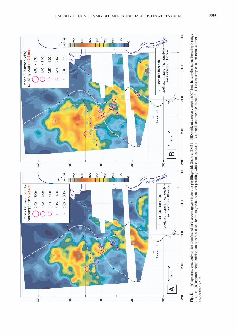
Pre cise es ti ma tion of the hor i zon tal ex tent of the men -tioned LRP was pos si ble by means of de tailed elec tro mag -netic in duc tion pro fil ing with EM31 equip ment (Moœcicki,2009). The data ob tained with EM31 en abled con struc tionof ap par ent con duc tiv ity maps cov er ing the most in ter est ing part of the study area. These maps are shown in Fig. 2A, B.Map in Fig. 2A rep re sents con tours for hor i zon tal di poles(HD) mea sur ing mode of EM31. In this case “mean” con -duc tiv ity of sed i ments (which de pends on spa tial dis tri bu -tion of spe cific con duc tiv ity and on mea sur ing char ac ter is -tics of the method used) are mea sured to the depth of about3 m. The map in Fig. 2B was con structed for ver ti cal di pole(VD) mode mea sure ments and depth of in ves ti ga tion ofabout 6 m may be as sumed for that case. The high est val uesof ap par ent con duc tiv ity, sa, were ob served for HD mode inthe places, where sur face oc cur rences of salt wa ter out flows were no ticed. Mea sured val ues were higher than 700–800mS/m in the vi cin ity of “mud vol ca noes” and in NE sur -round ings of the Nadzieja-1 well. The comparison of thesetwo maps is indicative of general rise of conductivity withdepth.
Vari a tions of sed i ment con duc tiv ity with depth was es -ti mated from the pen etrom eter-based re sis tiv ity pro fil ing.Mea sured re sis tiv ity data (in Wm) were trans formed to con -duc tiv ity val ues (mS/m), which are more con ve nient for dis -cuss ing the sa lin ity prob lems. Ver ti cal pro files of con duc -tiv ity were pre sented in Fig. 3 to gether with geo log i cal andgeo chem i cal data.
Geo chem i cal data
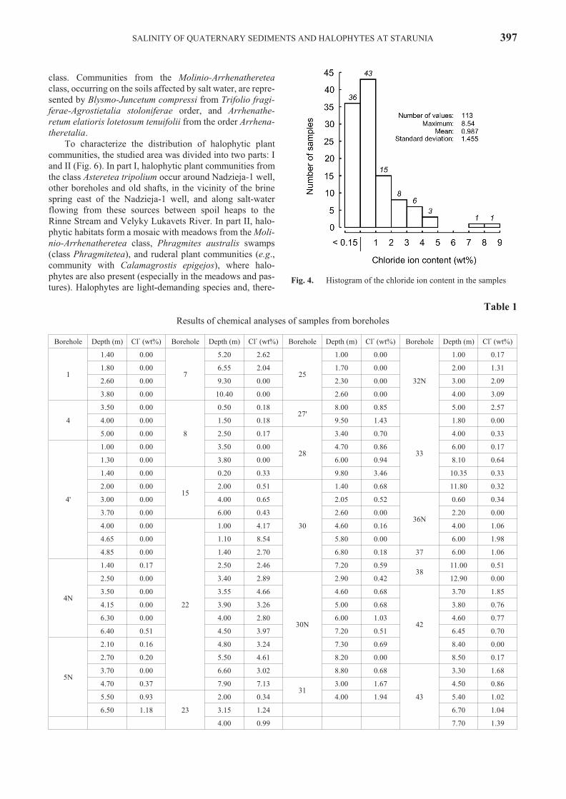
The con tent of Cl- ion in the whole pop u la tion of sam -ples dis plays vari abil ity in the range from 0 to 8.54 wt%. Inal most one third of the sam ples, chlo ride is be low the limitof de tec tion (0.15) (Fig. 4 and Ta ble 1). These sam ples canbe rec og nized as Cl-free. Most of the Cl-free sam ples be -long to bore holes Nos 1, 4, 4’ and 25, which are lo cated in
the north-east ern and cen tral part of the study area (Fig. 2A,B). Their lo ca tion cor re sponds to the area of the low est ap -par ent con duc tiv ity. Other Cl-free sam ples mainly comefrom the bore holes 4N, 7 and 8, which are lo cated in thesouth-east ern part of the area where con duc tiv ity is rel a -tively low, too. As to the other bore holes, only in a few sam -ples Cl- ion presence was not detected.
Most of the sam ples, in which Cl- ion con tent wasabove the de tec tion limit, show val ues be low 1 wt% (Fig.4). It is worth men tion ing that val ues higher than 2 wt%were ob served in all 13 sam ples taken from bore hole No.22, where the high est val ues (8.54 and 7.13 wt%) were no -ticed, too. The re main ing sam ples with Cl- con tent above 2wt% were taken from bore holes: 32N (3 sam ples), 7 (2 sam -ples) and 28 (1 sample).
Ex cept the bore holes, in which sam ples do not havechlo ride ion above the limit of de tec tion, the re main ingbore holes show large di ver sity of mean con tents in therange from 0.16 to 4.11 wt% (Ta ble 1). In most of them, themean value does not ex ceed 1 wt%. There are sam ples withmean value above 1 wt% from 7 bore holes only (namely,Nos 7, 22, 27, 28, 31, 32N and 43). These bore holes are lo -cated along the NW–SE belt of high elec tric con duc tiv ityzone (Figs 2A, B and 6).
Bo tan i cal data
The area of the aban doned ozokerite mine in Staruniahas a typ i cal post-in dus trial spon ta ne ous veg e ta tion, witha mosaic of ruderal, semi-nat u ral and nat u ral hab i tats (Fig.6). Most of the area is oc cu pied by anthropogenic hab i tats:waste heaps, rem nants of mine shafts and bore holes. In themost dis turbed cen tral part, ex cept for ar eas not col o nizedby vas cu lar plants, two types of hab i tats are widely dis trib -uted: dry hab i tats on waste heaps were col o nized by com -mu nity with Calamagrostis epigejos, while moist placeswere oc cu pied by reed swamps (Phragmitetum aus tra lis),which oc curred along the Rinne Stream and Velyky Luka-vets River as well. Other plant com mu ni ties oc cu pied smallar eas and were scat tered (e.g., patches of sedge or Typhaswamps, fens, wet mead ows), how ever, fresh mead ows andpastures dominate on the slopes of the valley.
Among the most in ter est ing hab i tats are halophyticplant com mu ni ties, in clud ing ag gre ga tion of salt-tol er atedvascular plant spe cies. Con tem po rary flora of vas cu larplants in the stud ied area counted 230 spe cies. Amongthem, 80 spe cies are con sid ered in Eu rope as salt-tol er ant(Wilkoñ-Michalska, 1963; Lindacher, 1995; Zarzycki et al., 2002). They showed dif fer ent salt tol er ance and fre quencyin sa line hab i tats. Halophytes in di cat ing higher salt con cen -tra tion in the soil are given in Table 2.
The most salt-tol er ated veg e ta tion is rep re sented bycom mu ni ties from the or der Glauco-Puccinellietalia andAsteretea tripolium class: Puccinellio-Spergularietum sali-nae with Spergularia sa lina, Puccinellia distans, and Lo tustenuis, and com mu nity with Triglochin maritimum con -nected with flows and wet ter parts of halophytic hab i tats.Dips filled with wa ter in the vi cin ity of salt wa ter sourceswere oc cu pied by Scirpetum maritimi with dom i nat ingSchoenoplectus tabernaemontani from the Phragmitetea
394 W. J. MOŒCICKI ET AL.
SA LIN ITY OF QUA TER NARY SED I MENTS AND HALOPHYTES AT STARUNIA 395
.2 .giF
(
Al
C fo tne tnoc naem dna edo
m D
H – 13M
E scinoeG hti
w gn ili forp noi tcu dni cite nga mor tcele no desab sruo tnoc
yt ivi tcu dnoc tn era ppa )-
egnar htped morf nekat sel p
mas ni snoi ( ;
m 5.3–0B
lC fo tne tnoc nae
m dna edom
DV – 13
ME scinoe
G htiw gn ili forp noi tcu dni cite nga
mor tcele no desab sruo tnoc yt ivi tcu dnoc tn era ppa )
-stne
m ides morf nekat sel p
mas ni snoi m 5.3 naht repeed
396 W. J. MOŒCICKI ET AL.
.3 .giF
lC dna ,seroc
morf deter pre tni seli forp cihpargitartsohil ,stne meru sae
m desab-ret emort enep
morf htped htiw stne
m ides fo yt ivi tcu dnoc fo noi tu bir tsi
D
-.sel p
mas desy lana ni tne tnoc snoi
ene coiM – 9 ,dnas – 8 ,levarg – 7 ,ne
mu tib yb deta r utas citsalc dna esraoc – g6 ,eni
mutib yb deta r utas du
m – d6 ,dum
yeyalc – 5 ,du
m cinegoib – 4 ,dum taep – 3 ,taep – 2 ,p
mud enim – 1 :slo b
my
Satarts gn iraeb-tlas
class. Com mu ni ties from the Molinio-Arrhenathereteaclass, oc cur ring on the soils af fected by salt wa ter, are rep re -sented by Blysmo-Juncetum compressi from Trifolio fragi-ferae-Agrostietalia stoloniferae or der, and Arrhenathe-retum elatioris lotetosum tenuifolii from the or der Arrhena-theretalia.
To char ac ter ize the dis tri bu tion of halophytic plantcom mu ni ties, the stud ied area was di vided into two parts: Iand II (Fig. 6). In part I, halophytic plant com mu ni ties fromthe class Asteretea tripolium oc cur around Nadzieja-1 well,other bore holes and old shafts, in the vi cin ity of the brinespring east of the Nadzieja-1 well, and along salt-wa terflow ing from these sources be tween spoil heaps to theRinne Stream and Velyky Lukavets River. In part II, halo-phytic hab i tats form a mo saic with mead ows from the Moli-nio-Arrhenatheretea class, Phragmites aus tra lis swamps(class Phragmitetea), and ruderal plant com mu ni ties (e.g.,com mu nity with Calamagrostis epigejos), where halo-phytes are also pres ent (es pe cially in the mead ows and pas -tures). Halophytes are light-de mand ing spe cies and, there -
SA LIN ITY OF QUA TER NARY SED I MENTS AND HALOPHYTES AT STARUNIA 397
Fig. 4. His to gram of the chlo ride ion con tent in the sam ples
Ta ble 1
Re sults of chem i cal anal y ses of sam ples from bore holes
fore, swamps with ex tremely ex pan sive and tall Phragmitesaus tra lis can re duce their dis tri bu tion on the soils withlower salt con cen tra tion. Smaller patches of halophytic veg -e ta tion in the up per part of the slope were con nected withsa line spring (the most west ern patch), as well as old bore -holes (Jadwiga, Kaufmann 1), and the big gest one oc curredaround main mud vol cano. Gen er ally, the pat tern of halo-phytes dis tri bu tion re flect pres ence of salt wa ter sources,and their flows and soils af fected by them. The RinneStream col lects sa line wa ter flowing from the abovementioned sources, but no water halophyte was noted.
Veg e ta tion of sa line soils rep re sent three types of dis tri -bu tion: (i) con cen tric (around sa line source, e.g., aroundmud vol cano in part II, springs on slopes of the val ley inboth parts of the study area, and places in un dated by sa linewa ter), (ii) lin ear (along nar row salt wa ter flows me an der -ing be tween waste heaps in part I), and (iii) scat tered (ondry waste heaps in part I). On the veg e ta tion map (Fig. 6),ar eas oc cu pied by all types were marked to gether as com -mu ni ties from the class Asteretea tripolium. In the first two
types of veg e ta tion dis tri bu tion, char ac ter is tic zonation ofplant com mu ni ties de pend ing on the sa lin ity of soil was ob -served. In the lin ear type of dis tri bu tion, a stream of sa linewa ter was oc cu pied by com mu ni ties with Triglochin mariti- mum and other oblig a tory halophytes, on the edges appea-red sin gle non-halophilous plants to gether with halophytes,and the next were plant com mu ni ties with dom i nance ofnon-halophilous plants. In the con cen tric type of dis tri bu -tion, there was a char ac ter is tic area with the lack of plantslo cal ized in the clos est sur round ing of sa line flow, es pe -cially wide around the mud vol cano and old shafts in part II, and much smaller around sa line springs in both parts. Be -cause of the mo saic char ac ter and small-area patches of sa -line veg e ta tion, places un cov ered by plants are not markedwithin halophytic patches in Fig. 6. The size of the area un -oc cu pied by plants was re lated to sa lin ity of wa ter and ca -pac ity of the sa line source. Vas cu lar plants were not able tocol o nize this area be cause of too high sa lin ity of out flowsand soil. The sa lin ity of wa ter sam pled from se lected sa linesources in Sep tem ber 2008 show value up to 178 g/l Cl- ions
SA LIN ITY OF QUA TER NARY SED I MENTS AND HALOPHYTES AT STARUNIA 399
Fig. 6. Veg e ta tion map of the study area. I and II – two main ar eas of dis tri bu tion of halophytes, 1–6 – lo ca tion of wa ter sam ples an a -lyzed for chlo ride ion content
in the mud vol cano out flow (Fig. 6), whereas the oblig a toryhalophytes noted in Starunia were able to grow on soil withmuch lower sa lin ity. Spergularia sa lina col o nized the mostsa line soils (more than 23 g/l Cl- ions; Ta ble 2), form ing thefirst zone of veg e ta tion. Next was the zone of Puccinellio-Spergularietum, where S. sa lina co-oc curred with Pucci-nellia distans, Lo tus tenuis, and other spe cies, mainly fac ul -ta tive halophytes, and the last was zone of meadows,swamps or ruderal com mu ni ties with halophytes. The num -ber of halophytes grad u ally de creases with dis tance to sa -line source, while the num ber of non-halophilous speciesincreases. Besides above mentioned types of distribution,halophytic vegetation also shows mosaic of patches withdifferent plant communities.
COM MENTS
Al though three dif fer ent meth ods were ap plied in thisstudy, the tar get was the same: doc u ment the sa lin ity of sed -i ments, un der ground wa ter and soils (veg e ta tion). There -fore, the re sults of in di vid ual meth ods, de spite more or lessob vi ous dif fer ences, complement one another.
In Fig. 2 ap par ent con duc tiv ity con tours based on elec -tro mag netic in duc tion pro fil ing method are set to getherwith sa lin ity re sults ob tained from chem i cal anal y ses ofcore sam ples. Fig. 2A pres ents the dis tri bu tion of con duc -tiv ity and sa lin ity within top 3–3.5 metres of the near-sur -face sed i ments, while Fig. 2B gives a com par i son of datafrom deeper strata. There is gen er ally a good cor re la tion be -tween sa lin ity and con duc tiv ity data, es pe cially for deepersed i ments, i.e. for sVD and sa lin ity for depth > 3.5 m (Fig.2B). When an a lyz ing dif fer ences one should bear in mindthat sa lin ity data from cores are “point data”, while ap par ent con duc tiv ity from sur face pro fil ing are “spa tially av er ageddata”, so only qual i ta tive com par i son can be made for thesedata sets. The sit u a tion is a bit dif fer ent in the case, wherere sults of bo tan i cal stud ies (Fig. 6) are com pared with shal -low con duc tiv ity data (Fig. 2A). Both data are pre sented inthe form of sur face maps, al though depth range for bothtypes of in for ma tion is dif fer ent. There are places of goodcor re la tion be tween pres ence of halophytes and higher ap -par ent con duc tiv ity of near-sur face sed i ments. This mainlyoc curred in the vi cin ity of the mud vol cano and north of that point. In no other parts of the study area such ob vi ous re la -tions can be ob served. There fore, it may be guessed that inother places, ex cept mud vol cano and its vi cin ity which arecol o nized by halophytes, the higher amount of salt is pres -ent only in the thin top soil layer. Such local soil enrichment in salt can be an effect of local intense outflows of brines orseasonal floods.
Dis tri bu tion of sa lin ity with depth can be as sessed fromFig. 3, where ver ti cal pro files of con duc tiv ity, re sults ofsam ple anal y ses and lithostratigraphy of sed i ments are setto gether. Gen er ally higher Cl- ion con tent is con firmed byhigher con duc tiv ity value. For most places where Cl- ionspres ence was not de tected the con duc tiv ity is rel a tively low, too. Nev er the less, there are many ex cep tions to these“rules”. The main rea son lies in a dif fer ent lo ca tion of thebore holes and pen e tra tion sites (tech ni cally it is not pos si ble
400 W. J. MOŒCICKI ET AL.
Ta ble 2
Halophytes noted in Starunia with their sa lin ity tol er ance,ac cord ing to Lindacher (1995)
Species Phytosociological unit *
> 23 g/l Cl- ions
Spergularia salina J. Presl & C.Presl
Asteretea tripolium(Puccinellio-Spergularietum
salinae)
16–23 g/l Cl- ions
Triglochin maritimum L. Asteretea tripolium
12–16 g/l Cl- ions
Puccinellia distans (Jacq.) Parl.Asteretea tripolium
Sonchus arvensis L. subsp.uliginosus (M. Bieb.) Nyman
Phragmitetea
Typha angustifolia L. Phragmitetea
Typha latifolia L. Phragmitetea
For the last group (0–1 g/l Cl- ions) only ex am ples are given. * – ac cord ing
to Matuszkiewicz (2001) and Zarzycki et al. (2002), ** – in the study area
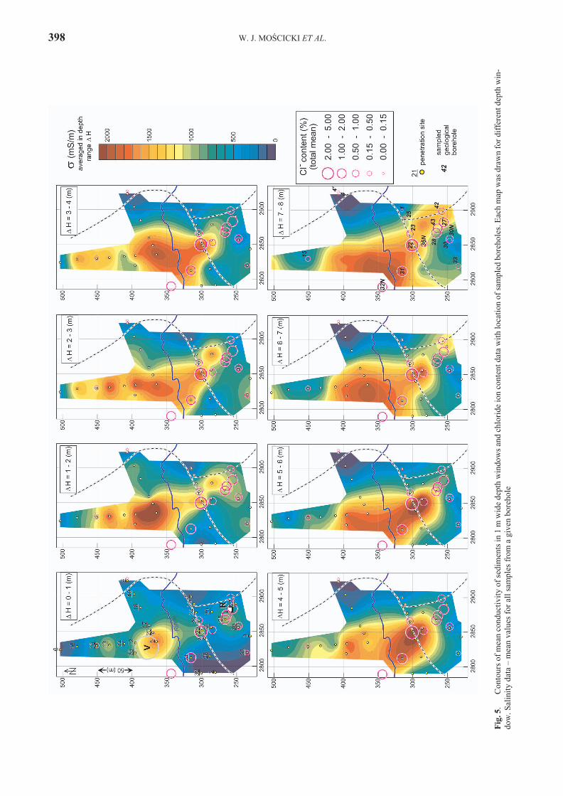
to make two holes in the same place) and high het er o ge ne ity of the geo log i cal me dium. For more gen eral as sess ment ofdepth/sur face vari abil ity of sed i ments, elec tric prop er tiesthe con duc tiv ity val ues were av er aged in 1 m wide depthwin dows for each pen e tra tion site. Then, these mean val uesof con duc tiv ity were used for mak ing maps of dif fer entdepths – depth slices, shown in Fig. 5. Information aboutcore samples salinity was added to these maps.
CON CLU SIONS
Three dif fer ent meth ods were ap plied in the area of theaban doned ozokerite mine at Starunia to as sess sa lin ity ofthe sed i ments, un der ground wa ter and soils (veg e ta tion).
Elec tro mag netic ter rain con duc tiv ity mea sure mentswith Geonics EM31 en abled the de ter mi na tion of the sur -face ex tent of high-con duc tiv ity Qua ter nary sed i ments,which may be iden ti fied with sed i ments filled with salinewater.
In the vi cin ity of sa line wa ter out flows spe cific veg e ta -tion was noted, with halophytes in di cat ing in creased saltcon cen tra tion in the soil. Their range partly cor re lates withsur face dis tri bu tion of ap par ent con duc tiv ity of the near-sur face sediments.
The dis tri bu tion of sa lin ity with depth was in ves ti gateddi rectly by chem i cal anal y sis of sed i ment sam ples takenfrom bore holes and in di rectly by pen etrom eter-based con -duc tiv ity mea sure ments. The high est chlo ride ion con cen -tra tion re ported in sam ples reached nearly 8.5 wt%. Bothnear-sur face sed i ments and deeper strata (in clud ing Mio -cene) are highly sa line, what is quite vis i ble on the conduc-tivity maps for different depths.
Ac knowl edge ments
Fi nan cial sup port from the Min is try of Sci ence and HigherEd u ca tion (grant No. 139/UKR/2006/01) is kindly ac knowl edged.Re view com ments and sug ges tions by Jan Bromowicz and JerzyFija³ of the AGH Uni ver sity of Sci ence and Tech nol ogy inKraków were very help ful. We would like to ex press our grat i tudeto Paul Lillis of U.S. Geo log i cal Sur vey in Den ver for his crit i calcom ments, which im proved this pa per.
REF ER ENCES
Adamenko, O. M., Kryzhanivsky, Y. I., Vekeryk, V. I., Stelmakh,O. R., Mishchenko, L. V., Zorina, N. O., Zorin, D. O. &Ambrozyak, M. V., 2005. A con cept of an in ter na tional“Ice-Age Geopark” as an eco log i cal-tour ist cen ter in Staruniafor mer ozokerite mine, fore-Carpathian re gion, Ukraine. In:Kotarba, M. J. (ed.), Pol ish and Ukrai nian geo log i cal stud ies(2004–2005) at Starunia – the area of dis cov er ies of woollyrhi noc er oses. Pol ish Geo log i cal In sti tute and So ci ety of Re -search on En vi ron men tal Changes “Geosphere”, Warszawa–Kraków: 205–210.
Alexandrowicz, S. W., 2004. Starunia i badania czwartorzêdu wtradycji i inicjatywach Polskiej Akademii Umiejêtnoœci. (InPol ish). Studia i materia³y do dziejów Polskiej AkademiiUmiejêtnoœci, Kraków, 3, 261 pp.
Alexandrowicz, S. W., 2005. The his tory of Starunia – a paleon-
tologic site and old ozokerite mine. In: Kotarba, M. J. (ed.),Pol ish and Ukrai nian geo log i cal stud ies (2004–2005) at Sta-runia – the area of dis cov er ies of woolly rhi noc er oses. Pol ishGeo log i cal In sti tute and So ci ety of Re search on En vi ron men -tal Changes “Geosphere”, Warszawa–Kraków: 21–36.
Antoniuk, J. & Moœcicki, W. J., 1994. Metoda penetracyjnegoprofilowania opornoœci elektrycznej 1998 – przyk³ady zasto-sowañ (In Pol ish). Przegl¹d Geologiczny, 42: 857–862.
Dubyna, D. V., Dziuba, T. P., Neuhäuslová, Z., Solomakha, V. A., Tyshchenko, O. V. & Shelyag-Sosonko, Yu. R., 2007. Halo-phytic veg e ta tion. Classes Bolboschoenetea maritimi, Fes-tuco-Puccinellietea, Molinio-Juncetea, Crypsietea aculeatae, Thero-Salicornietea strictae, Salicornietea fruticosae, Jun-cetea maritimi. (In Ukrai nian, Eng lish sum mary). M. G.Kholodny In sti tute of Bot any, Na tional Acad emy of Sci encesof Ukraine, Kyiv, 314 pp.
Duliñski, M., Ró¿añski, K. & Kotarba, M. J., 2005. Iso to pic andchem i cal com po si tion of sur face and groundwaters in theStarunia area, fore-Carpathian re gion, Ukraine. In: Kotarba,M. J. (ed.), Pol ish and Ukrai nian geo log i cal stud ies (2004–2005) at Starunia – the area of dis cov er ies of woolly rhi noc -er oses. Pol ish Geo log i cal In sti tute and So ci ety of Re searchon En vi ron men tal Changes “Geosphere”, Warszawa–Kra-ków: 187–194.
Kobranova, V. N., 1989. Petrophysics. Mir Pub lish ers, Mos cow & Springer-Verlag, Berlin, 375 pp.
Kornaœ, J., 1966. As so ci a tions of sa line soils. In: Szafer, W. (ed.),The veg e ta tion of Po land. Pergamon Press, Ox ford, Lon don,Ed in burgh, New York, Paris, Frank furt, PWN – Pol ish Sci en -tific Pub lish ers, Warszawa: 324–330.
Kotarba, M. J. (ed.), 2005. Pol ish and Ukrai nian geo log i cal stud -ies (2004–2005) at Starunia – the area of dis cov er ies ofwoolly rhi noc er oses. Pol ish Geo log i cal In sti tute and So ci etyof Re search on En vi ron men tal Changes “Geosphere”, War-szawa–Kraków, 218 pp.
Kotarba, M. J., 2009. In ter dis ci plin ary stud ies at Starunia palaeon- tological site and vi cin ity (Carpathian re gion, Ukraine) in theyears 2006–2009: pre vi ous dis cov er ies and re search, pur -poses, re sults and per spec tives. Annales Societatis Geo-logorum Poloniae, 79: 219–241.
Kotarba, M. J., Wiêc³aw, D., Tobo³a, T., Zych, H., Kowalski, A. & Ptak, S., 2009. Bi tu men and salt con tents within the Qua ter -nary sed i ments at Starunia palaeontological site and vi cin ity(Carpathian re gion, Ukraine). Annales Societatis Geologorum Poloniae, 79: 447–461.
Lindacher, R., 1995. PHANART. Datenbank der GefässpflanzenMitteleuropas. Erklärung der Kennzahlen, Aufbau und Inhalt.Veröffentlichungen des Geobotanischen In sti tutes der ETH,Stiftung Rübel, Zürich, 125: 1–436.
£omnicki, M., 1914. Dol ina £ukawca Wielkiego i Ma³ego (Sta-ruñsko-Mo³otkowska). (In Pol ish). In: Bayger, J. A., Hoyer,H., Kiernik, E., Kulczyñski, W., £omnicki, M., £omnicki, J.,Mierzejewski, W., Niezabitowski, W., Raciborski, M.,Szafer, W. & Schille, F. (eds), Wykopaliska Staruñskie.Muzeum im. Dzieduszyckich, Lwów, 15: 11–14.
Matuszkiewicz, W., 2001. Przewodnik do oznaczania zbiorowiskroœlinnych Polski. (In Pol ish). Wydawnictwo NaukowePWN, Warszawa, 537 pp.
McNeil, J. D., 1980. Elec tri cal con duc tiv ity of soils and rocks.Tech ni cal Note TN-5. Geonics Lim ited, Mississauga, On tario, Can ada, 32 pp.
Mirek, Z., Piêkoœ-Mirkowa, H., Zaj¹c, A. & Zaj¹c, M., 2002.Flow er ing plants and pteri do phytes of Po land. A check list.W. Szafer In sti tute of Bot any, Pol ish Acad emy of Sci ences,Kraków, 442 pp.
SA LIN ITY OF QUA TER NARY SED I MENTS AND HALOPHYTES AT STARUNIA 401
Moœcicki, W. J., 2005. Char ac ter iza tion of near-sur face sed i mentsbased on DC re sis tiv ity soundings in the Starunia area, fore-Carpathian re gion, Ukraine. In: Kotarba, M. J. (ed.), Pol ishand Ukrai nian geo log i cal stud ies (2004–2005) at Starunia –the area of dis cov er ies of woolly rhi noc er oses. Pol ish Geo -log i cal In sti tute and So ci ety of Re search on En vi ron men talChanges “Geosphere”, Warszawa–Kraków: 103–114.
Moœcicki, W. J., 2009. Char ac ter iza tion of near-sur face sed i mentsbased on com bined geoelectric stud ies at Starunia palaeonto-log i cal site and vi cin ity (Carpathian re gion, Ukraine). Anna-les Societatis Geologorum Poloniae, 79: 333–342.
Moœcicki, W. J. & Antoniuk, J., 2002. Zastosowanie metod geo-elektrycznych w badaniach zwi¹zanych z ochron¹ œrodo-wiska geologicznego. (In Pol ish). Pub li ca tions of the In sti tute of Geo phys ics, Pol ish Acad emy of Sci ences, M-27 (352):179–193.
Moœcicki, W. J. & Soko³owski, T., 2009. Elec tric re sis tiv ity andcom pact ness of sed i ments in the vi cin ity of bore holes drilledin the years 2007–2008 in the area of Starunia palaeontolog i -cal site (Carpathian re gion, Ukraine). Annales SocietatisGeologorum Poloniae, 79: 343–355.
Soko³owski, T., Stachowicz-Rybka, R. & Woronko, B., 2009. Up -per Pleis to cene and Ho lo cene de pos its at Starunia palaeonto-log i cal site and vi cin ity (Carpathian re gion, Ukraine). Anna-les Societatis Geologorum Poloniae, 79: 255–278.
Trzciñska-Tacik, H. & Woch, M., 2005. Halophytic plant com mu -ni ties near Drogobych (West ern Ukraine). In: XVII In ter na -tional Bo tan i cal Con gress, Vi enna 17–23 July 2005,Ab stracts: 576.
Wilkoñ-Michalska, J., 1963. The halophytes from Kujawy. StudiaSocietatis Scientiarum Torunensis, Sectio D (Botanica), 7(1):1–122.
Zapa³owicz, H., 1911. Krytyczny przegl¹d roœlinnoœci Galicyi. 3.(In Pol ish). Wydawnictwo Akademii Umiejêtnoœci, Kraków,246 pp.
Zarzycki, K., Trzciñska-Tacik, H., Ró¿añski, W., Szel¹g, Z.,Wo³ek, J. & Korzeniak, U., 2002. Eco log i cal in di ca tor val ues of vas cu lar plants of Po land. W. Szafer In sti tute of Bot any,Pol ish Acad emy of Sci ences, Kraków, 183 pp.