funding provided by: California State Coastal Conservancy California Resources Agency Gordon and Betty Moore Foundation David and Lucile Packard Foundation California Coastal and Marine Initiative of the Resources Legacy Fund Foundation Richard and Rhoda Goldman Fund US Fish and Wildlife Service Coastal Program at San Francisco Bay US Fish and Wildlife Service Landscape Conservation Cooperative Technical assistance provided by: National Park Service Rivers, Trails and Conservation Assistance Program A Project of the Bay Area Open Space Council
Transcript
Upland Goals
Project
funding provided by: California State Coastal Conservancy
California Resources Agency Gordon and Betty Moore Foundation David and Lucile Packard Foundation
California Coastal and Marine Initiative of the Resources Legacy Fund Foundation Richard and Rhoda Goldman Fund
US Fish and Wildlife Service Coastal Program at San Francisco Bay US Fish and Wildlife Service Landscape Conservation Cooperative
Technical assistance provided by: National Park Service Rivers, Trails and
Conservation Assistance Program
A Project of the Bay Area Open Space Council
Upland Goals
Project
• Upland Habitat Goals - Status
• Conservation Lands – Definitions
• Upland Goals Methodology Review
• Upland Goals and Climate Change
• UG Explorer – Online Decision Support
• Downscaled Isoclimate Data
• Climate Gap Analysis – Protected, CLN, Converted, Gaps
• Next Steps
• Questions/Discussion
Upland Goals
Project
Acreage Statistics:
California = 101.4 Million Acres
SF Bay Area = 4.5 Million Acres
_________________________
LANDSCAPE
Protected = ~ 1.15 Million Acres!
Urban = ~ 800,000 Acres
Not Protected = 2.5 Million Acres
Upland Goals
Project
Regional Biodiversity Conservation Plan
How many acres of what types of habitats and in what configuration to preserve biodiversity in 9-county Bay Area?
Identify a NETWORK of conservation lands.
Upland Goals
Project
Conservation Lands: areas that support native biodiversity that are or will be protected from conversion by a variety of means including fee title, conservation easements, landowner cooperative agreement or other voluntary programs, land use policies and ordinances.
Conservation Lands Network: the configuration of conservation lands in a geographic area that provide for viable conservation of biodiversity through representation, connectivity, and stewardship.
Upland Goals
Project
Report with maps
Framework to allow incorporation of new data and update goals
Access to methods and tools for finer-scale planning
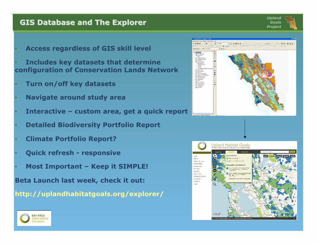
GIS Database - Available online now!
UG Explorer – Interactive Online Decision Support Tool interactive tool – Live!
www.uplandhabitatgoals.org
Upland Goals
Project
Purpose: represent the diversity of vegetation cover
60 cover types, 51 natural/semi-natural
30 m grid
Compromise between high resolution classification and even coverage across Bay Area
Expert opinion from Vegetation Focus Team
Update – FMMP Ag and Urban
Upland Goals
Project
29 Landscape Units (4 Urban Areas)
Based on physiographic features – valleys and mountains
Capture diversity and biogeography of vegetation across study area
Provide a means to break down recommendations into geographically coherent units.
Upland Goals
Project
500+ Vegetation Types in 29 Landscape Units
Conservation Targets
Blue Oak Woodland
Upland Goals
Project
Blue Oak Woodland
Doug Fir Forest
Upland Goals
Project
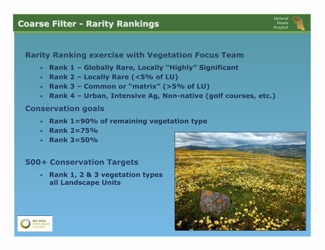
Rarity Ranking exercise with Vegetation Focus Team
• Rank 1 – Globally Rare, Locally “Highly” Significant • Rank 2 – Locally Rare (<5% of LU) • Rank 3 – Common or “matrix” (>5% of LU) • Rank 4 – Urban, Intensive Ag, Non-native (golf courses, etc.)
Conservation goals
• Rank 1=90% of remaining vegetation type • Rank 2=75% • Rank 3=50%
500+ Conservation Targets
• Rank 1, 2 & 3 vegetation types in all Landscape Units
Upland Goals
Project
Conservation Targets Vegetation Types x Landscape Units
Protection Goals – Rank 1,2,3 (90%,75%,50%)
Upland Goals
Project
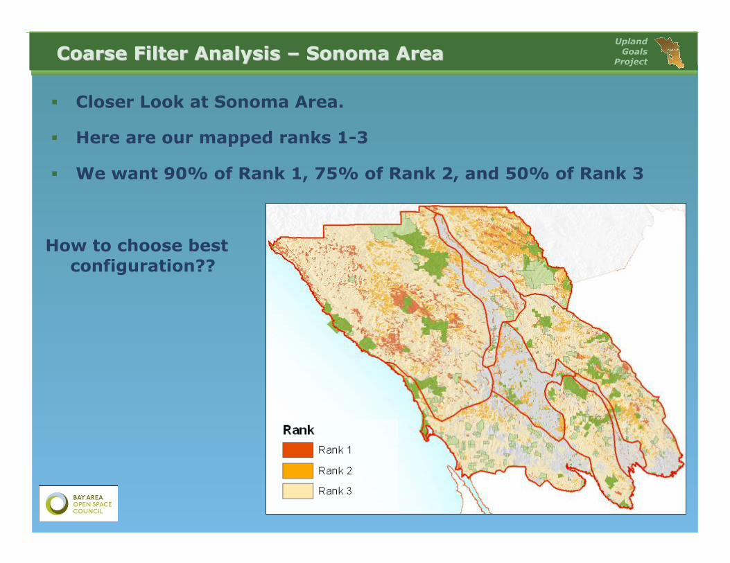
Closer Look at Sonoma Area.
Here are our mapped ranks 1-3
We want 90% of Rank 1, 75% of Rank 2, and 50% of Rank 3
How to choose best configuration??
Upland Goals
Project
Site Selection Model that meets set goals - MARXAN
Achieves an efficient Conservation Lands Network based on inputs:
1. Conservation Targets – Vegetation and Fine Filter 2. Conservation Goals – Rank 1,2,3 (90%,75%,50%) 3. Suitability of Landscape for Conservation –
fragmentation 4. Existing Protected Areas 5. Planning Units – 100 Hectare Hexagons ~250 acres
Starting Point for discussion
Upland Goals
Project
Near Final CLN
Some post Marxan Adujstmens – Local Connectivity
Upland Goals
Project
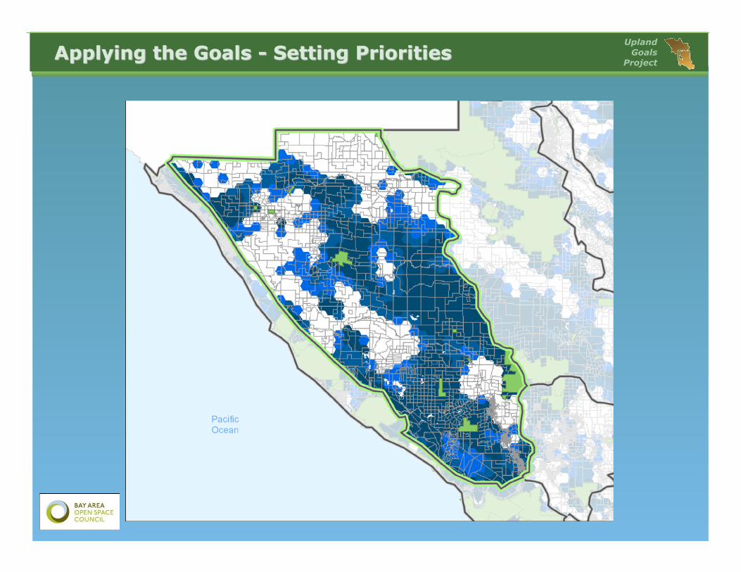
Areas ESSENTIAL to Conservation Goals (darkest blue). Planning units in this category were selected 16 or more times during 20 Marxan runs. The lands in this category were selected because they support high value conservation targets and/or are adjacent to existing protected lands. Conservation of these areas should be pursued since they serve vital functions in any potential network configuration and conservation goals will be difficult to meet without them.
Areas IMPORTANT to Conservation Goals (medium blue). Planning units in this category were selected between 11 and 15 times during 20 Marxan runs. Conservation opportunities in these areas should also be pursued as they represent habitats in areas of high conservation suitability and are generally adjacent to Areas Essential to Conservation Goals and protected lands.
Upland Goals
Project
• Upland Habitat Goals - Status
• Conservation Lands – Definitions
• Upland Goals Methodology Review
• Upland Goals and Climate Change
• UG Explorer – Online Decision Support
• Downscaled Isoclimate Data
• Climate Gap Analysis – Protected, CLN, Converted, Gaps
• Next Steps
• Questions/Discussion
Upland Goals
Project
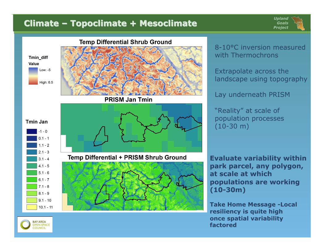
Coarse Filter builds in a buffer against climate change - setting high goals for each rarity ranked vegetation type in each landscape unit
Captures a broad range of mesoclimatic gradients that contributes to species richness
Linkages between large protected areas will provide room to move as temps change
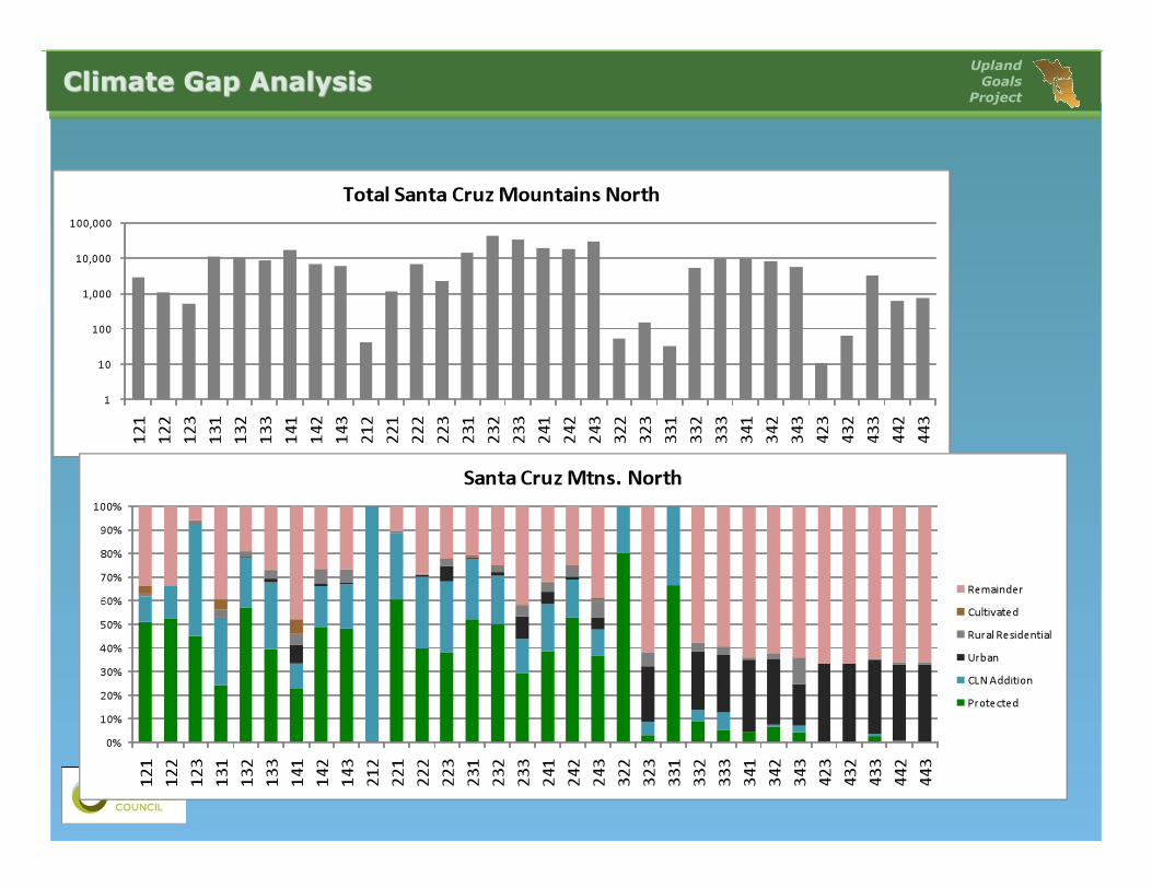
Gap analysis of climate coverage
January Minimum Temp
July Max Temp
Annual Precipitation
Upland Goals
Project
Evaluate the spatial range of any climate variable within any landscape unit
Upland Goals
Project
Not just GIS datasets
Preassembled project
Data organized into groups
Preset symbology
Cartographic set up
Clean attributes
Associated Handbook
Metadata coming soon
Incredible Resource for Bay Area Land Conservation Managers, Researchers and Planners.
GIS Database – Available Now!! www.uplandhabitatgoals.org/
Upland Goals
Project
Bay Area Protected Areas Database – BPAD http://www.openspacecouncil.org/
CAlands.org
Upland Goals
Project
Vegetation
Protected Lands
Suitability
Rarity
UG Biodiversity – Conservation Lands Network
Upland Goals
Project
• Access regardless of GIS skill level
• Includes key datasets that determine configuration of Conservation Lands Network
• Turn on/off key datasets
• Navigate around study area
• Interactive – custom area, get a quick report
• Detailed Biodiversity Portfolio Report
• Climate Portfolio Report?
• Quick refresh - responsive
• Most Important – Keep it SIMPLE!
Beta Launch last week, check it out:
http://uplandhabitatgoals.org/explorer/
Upland Goals
Project
Upland Goals
Project
Upland Goals
Project
Upland Goals
Project
Upland Goals
Project
Upland Goals
Project
Upland Goals
Project
Upland Goals
Project
Upland Goals
Project
Upland Goals
Project
• Upland Habitat Goals - Status
• Conservation Lands – Definitions
• Upland Goals Methodology Review
• Upland Goals and Climate Change
• UG Explorer – Online Decision Support
• Downscaled Isoclimate Data
• Climate Gap Analysis – Protected, CLN, Converted, Gaps
• Next Steps
• Questions/Discussion
Upland Goals
Project
• Isoclimates: similar climates
• Three most important climatic factors • Climatic Water Deficit • Tmin(DJF), • Tmax JJA
• 4 classes in each factor • 64 possible isoclimates • 50 present
Upland Goals
Project
Climatic Water Deficit: Annual evaporative
demand that exceeds available water
Upland Goals
Project
• CWD • 0-650 mm 1 • 650-800 mm 2 • 800-950 mm 3 • 950+ mm 4
Upland Goals
Project
• Tmin DJF • <4° C 1 • 4-5° C 2 • 5-6° C 3 • >6° C 4
Upland Goals
Project
• Tmax JJA • <22° C 1 • 22-26° C 2 • 26-30° C 3 • >30° C 4