20
BookletChart ™ San Pablo Bay NOAA Chart 18654 A reduced-scale NOAA nautical chart for small boaters When possible, use the full-size NOAA chart for navigation. Included Area
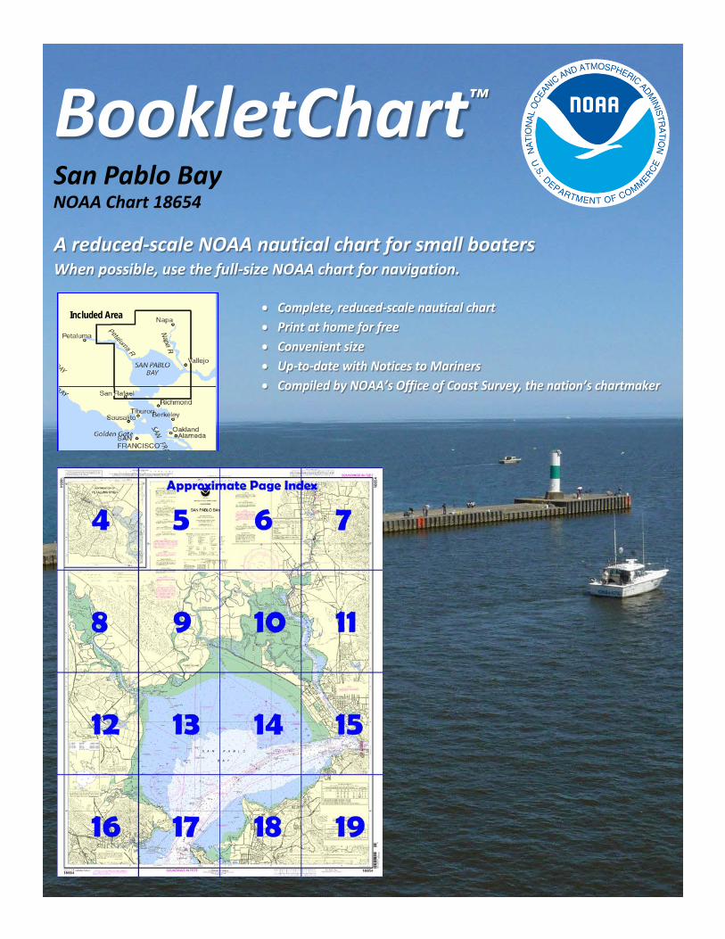
BookletChart™ San Pablo Bay NOAA Chart 18654
A reduced-scale NOAA nautical chart for small boaters When possible, use the full-size NOAA chart for navigation.
Included Area

2
Published by the National Oceanic and Atmospheric Administration
National Ocean Service Office of Coast Survey
www.NauticalCharts.NOAA.gov 888-990-NOAA
What are Nautical Charts?
Nautical charts are a fundamental tool of marine navigation. They show water depths, obstructions, buoys, other aids to navigation, and much more. The information is shown in a way that promotes safe and efficient navigation. Chart carriage is mandatory on the commercial ships that carry America’s commerce. They are also used on every Navy and Coast Guard ship, fishing and passenger vessels, and are widely carried by recreational boaters.
What is a BookletChart?
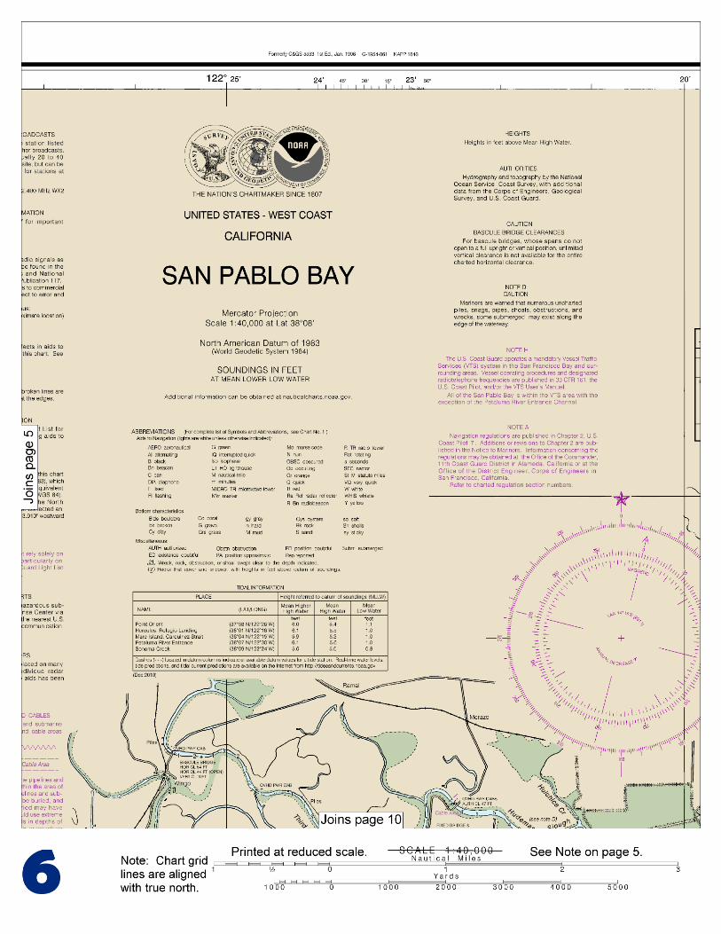
This BookletChart is made to help recreational boaters locate themselves on the water. It has been reduced in scale for convenience, but otherwise contains all the information of the full-scale nautical chart. The bar scales have also been reduced, and are accurate when used to measure distances in this BookletChart. See the Note at the bottom of page 5 for the reduction in scale applied to this chart.
Whenever possible, use the official, full scale NOAA nautical chart for navigation. Nautical chart sales agents are listed on the Internet at http://www.NauticalCharts.NOAA.gov.
This BookletChart does NOT fulfill chart carriage requirements for regulated commercial vessels under Titles 33 and 44 of the Code of Federal Regulations.
Notice to Mariners Correction Status
This BookletChart has been updated for chart corrections published in the U.S. Coast Guard Local Notice to Mariners, the National Geospatial Intelligence Agency Weekly Notice to Mariners, and, where applicable, the Canadian Coast Guard Notice to Mariners. Additional chart corrections have been made by NOAA in advance of their publication in a Notice to Mariners. The last Notices to Mariners applied to this chart are listed in the Note at the bottom of page 7. Coast Pilot excerpts are not being corrected.
For latest Coast Pilot excerpt visit the Office of Coast Survey website at http://www.nauticalcharts.noaa.gov/nsd/searchbychart.php?chart=18654.
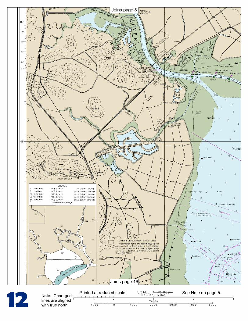
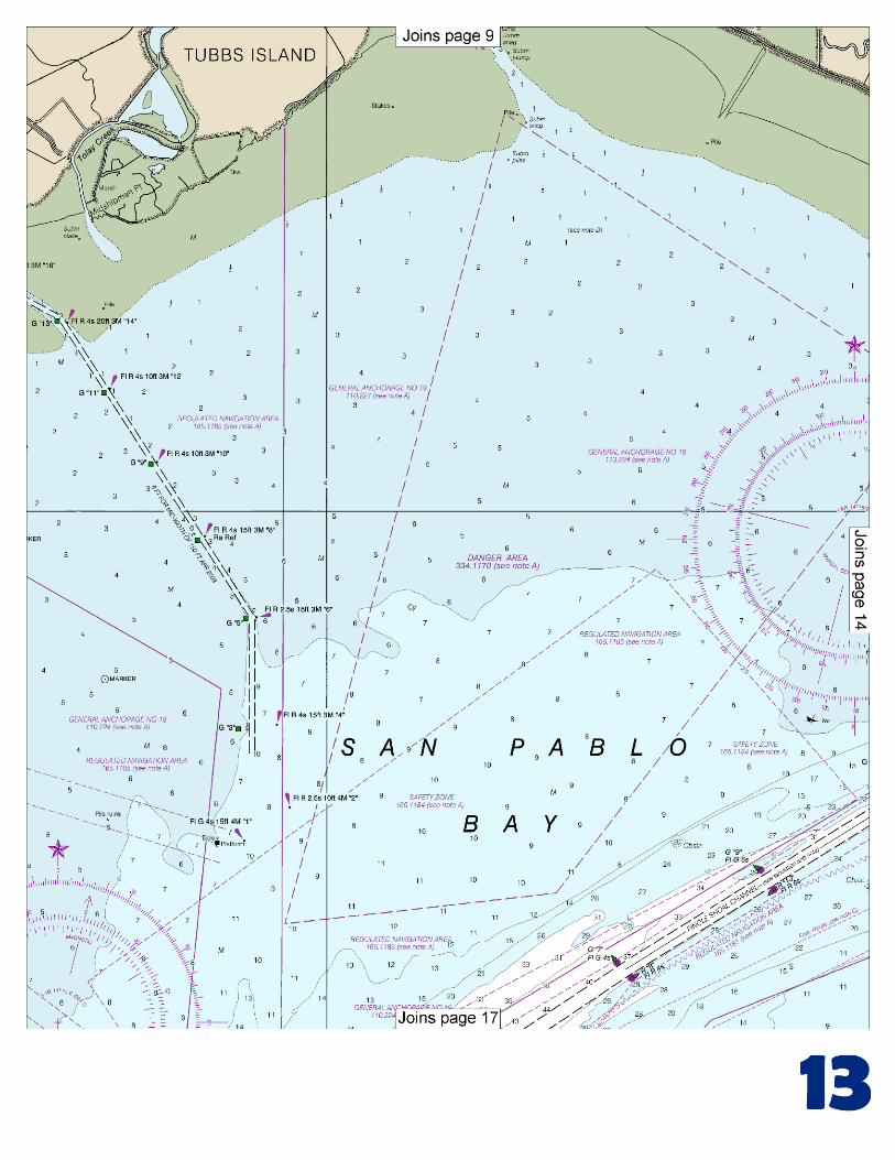
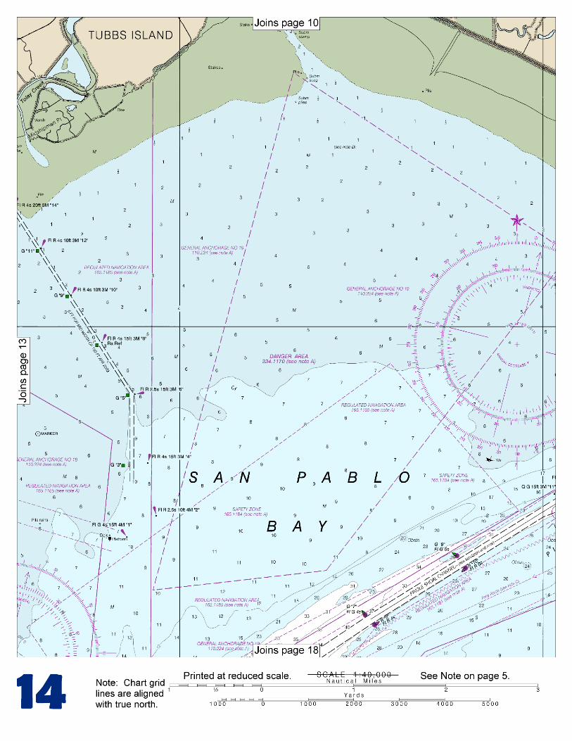
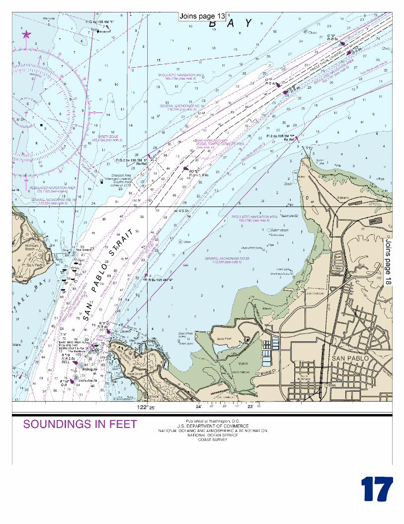
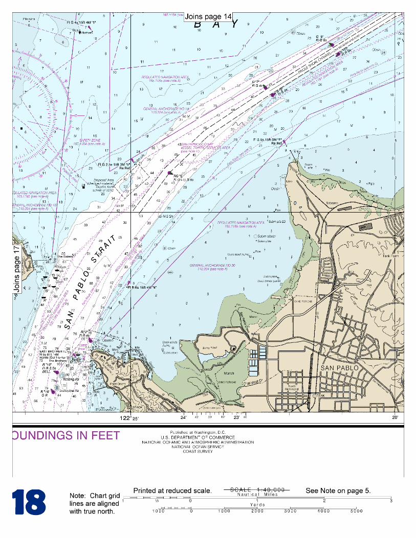
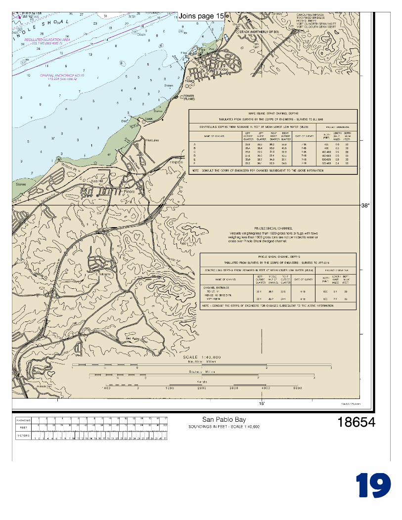
(Selected Excerpts from Coast Pilot) San Pablo Bay is nearly circular, 10 miles long in a NE direction, with a greatest width of 8 miles. The N part consists of low marshes intersected by numerous sloughs and a large area of shoal water and mudflats that bare at extreme low water. The S shore is bolder, except between Point San Pablo and Pinole Point, where it is low and marshy for about 3 miles. Carquinez Strait joins San Pablo Bay with Mare Island Strait and Suisun Bay at its E extremity. There is
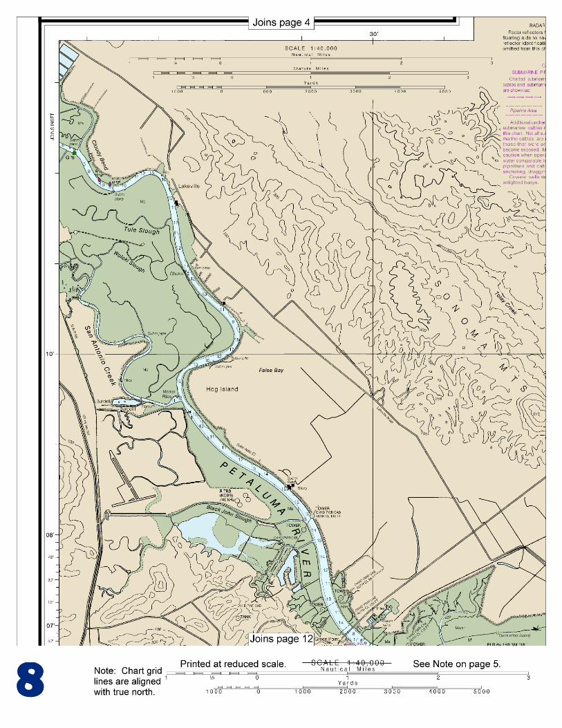
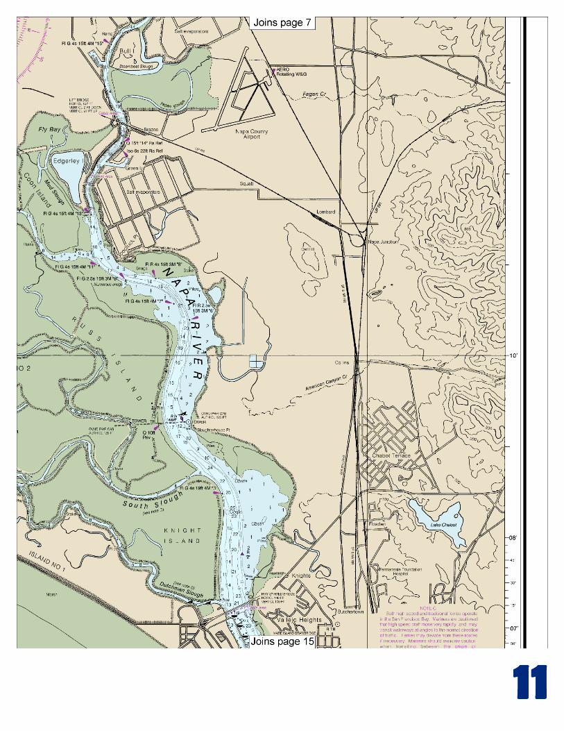
considerable traffic through the bay. Lighter draft vessels pass through bound for points on Suisun Bay, and the Sacramento River to Sacramento, and on the San Joaquin River to Stockton. A regulated navigation area has been established in San Pablo Bay N of the Pinole Shoal Channel. (See 33 CFR 165.1184, chapter 2, for limits and regulations.) Shoals and flats, which uncover, extend from Point San Pablo to Pinole Point, thence NE to Lone Tree Point. Pinole Point is a moderately high, rocky bluff, projecting about 1 mile from the SE shore of San Pablo Bay. A T-head fishing pier extends NW from the E side of the point. Piles and a light are off the face of the pier. The ruins of a former wharf extend from the E side of the point. A pleasure fishing pier and a small-craft harbor are at Lone Tree Point, 4.6 miles E from Pinole Point. (See the small-craft facilities tabulation on chart 18652 for services and supplies available.) Gallinas Creek enters San Pablo Bay about 1.5 miles NW of Point San Pedro. The entrance channel, marked by private markers on the N side, leads across flats to the mouth of the creek. In 1983, the channel had a controlling depth of 2 feet. Local knowledge is advised. Overhead cables crossing the creek have a minimum clearance of 65 feet. Petaluma River enters San Pablo Bay on the NW side. A dredged channel leads from deep water in San Pablo Bay to the mouth of the Petaluma River and continues upstream to the city of Petaluma. A Federal project provides for depths of 8 feet in the entrance and through the river to a turning basin at Petaluma, thence 4 feet to the upstream limit of the project. (See Notice to Mariners and latest edition of the chart for controlling depths.) Danger zones are in the E part of San Pablo Bay adjacent to the W shore of Mare Island and in the N central part of the bay. (See 334.1160 and 334.1170, chapter 2, for limits and regulations.) Napa River, the continuation of Mare Island Strait above the naval shipyard, is used by barges and pleasure boats. Napa River is marked to Horseshoe Bend by lights and a daybeacon; above Horseshoe Bend, the river is marked by lights and daybeacons to the 3rd Street Bridge in Napa. A visible wreck, marked by a buoy, is on the E side of the channel just N of Slaughterhouse Point. In 2004, a submerged obstruction was reported in the channel E of Knight Island in about 38°08'16.5"N., 122°16'57.2"W. The railroad bridge across Napa River at Brazos, about 6.8 miles above the Vallejo-Mare Island Causeway, has a vertical lift span with a clearance of 2 feet down and 97 feet up. When not in use, the drawspan is maintained in the open to navigation position. (See 117.1 through 117.59 and 117.169, chapter 2, for drawbridge regulations.) The channel through the bridge crosses from one bank to the other causing a hazardous condition, because the direction of the ebb current is as much as 50° from the axis of the channel. A fixed highway bridge with a clearance of 107 feet crosses the Napa River at Suscol, about 9.7 miles above the Vallejo-Mare Island Causeway. Near Imola, 12 miles above Vallejo-Mare Island Causeway bridge, a fixed highway bridge crosses the river with a clearance of 60 feet. The three fixed bridges in Napa have a minimum width of 47 feet and a clearance of 3.7 feet. The minimum clearance of the power cables crossing the river below Napa is 125 feet, and in Napa, 40 feet. A small-craft basin is on the W side of Napa River opposite Bull Island, 8 miles above the Vallejo-Mare Island Causeway, and several other small-craft facilities are elsewhere on the river.
U.S. Coast Guard Rescue Coordination Center 24 hour Regional Contact for Emergencies
RCC Alameda Commander
11th CG District (510) 437-3700 Alameda, CA

G
NOAA’s navigation managers serve as ambassadors to the maritime community. They help identify navigational challenges facing professional and recreational mariners, and provide NOAA resources and information for safe navigation. For additional information, please visit nauticalcharts.noaa.gov/service/navmanagers
To make suggestions or ask questions online, go to nauticalcharts.noaa.gov/inquiry. To report a chart discrepancy, please use ocsdata.ncd.noaa.gov/idrs/discrepancy.aspx.
Lateral System As Seen Entering From Seaward on navigable waters except Western Rivers
PORT SIDE
ODD NUMBERED AIDS
GREEN LIGHT ONLY
FLASHING (2)
PREFERRED CHANNEL
NO NUMBERS – MAY BE LETTERED
PREFERRED CHANNEL TO
STARBOARD
TOPMOST BAND GREEN
PREFERRED CHANNEL
NO NUMBERS – MAY BE LETTERED
PREFERRED CHANNEL
TO PORT
TOPMOST BAND RED
STARBOARD SIDE
EVEN NUMBERED AIDS
RED LIGHT ONLY
FLASHING (2)
FLASHING FLASHING
OCCULTING GREEN LIGHT ONLY RED LIGHT ONLY OCCULTING QUICK FLASHING QUICK FLASHING
ISO COMPOSITE GROUP FLASHING (2+1) COMPOSITE GROUP FLASHING (2+1) ISO
"1"
Fl G 6s
G "9"
Fl G 4s
GR "A"
Fl (2+1) G 6s
RG "B"
Fl (2+1) R 6s
"2"
Fl R 6s
8
R "8"
Fl R 4s
LIGHT
G
C "1"
LIGHTED BUOY
G
"5"
GR
"U"
GR
C "S"
RG
N "C"
RG
"G"
LIGHT
6
R
N "6"
LIGHTED BUOY
R
"2
"
CAN DAYBEACON
CAN NUN NUN
DAYBEACON
For more information on aids to navigation, including those on Western Rivers, please consult the latest USCG Light List for your area.
These volumes are available online at http://www.navcen.uscg.gov
Navigation Managers Area of Responsibility
Northeast
Lt. Meghan McGovern
Northwest and
Pacific Islands
Crescent Moegling
Great Lakes Region
Tom Loeper
Chesapeake and
Delaware Bay
Steve Soherr
California
Jeff Ferguson
[email protected] Mid-Atlantic
Lt. Ryan Wartick
Alaska
Lt. Timothy M. Smith
Western Gulf Coast
Alan Bunn
Central Gulf Coast
Tim Osborn
[email protected] South Florida
Puerto Rico
U.S. Virgin Islands
Michael Henderson
Southeast
Kyle Ward
2
2 C U 5
1


VHF Marine Radio channels for use on the waterways:Channel 6 – Inter-ship safety communications.Channel 9 – Communications between boats and ship-to-coast.Channel 13 – Navigation purposes at bridges, locks, and harbors.Channel 16 – Emergency, distress and safety calls to Coast Guard and others, and to initiate calls to other
vessels. Contact the other vessel, agree to another channel, and then switch.Channel 22A – Calls between the Coast Guard and the public. Severe weather warnings, hazards to navigation and safety warnings are broadcast here.Channels 68, 69, 71, 72 and 78A – Recreational boat channels.
Getting and Giving Help — Signal other boaters using visual distress signals (flares, orange flag, lights, arm signals); whistles; horns; and on your VHF radio. You are required by law to help boaters in trouble. Respond to distress signals, but do not endanger yourself.
EMERGENCY INFORMATION
Distress Call Procedures
• Make sure radio is on.• Select Channel 16.• Press/Hold the transmit button.• Clearly say: “MAYDAY, MAYDAY, MAYDAY.”• Also give: Vessel Name and/or Description;Position and/or Location; Nature of Emergency; Number of People on Board.• Release transmit button.• Wait for 10 seconds — If no responseRepeat MAYDAY call.
HAVE ALL PERSONS PUT ON LIFE JACKETS!
This Booklet chart has been designed for duplex printing (printed on front and back of one sheet). If a duplex option is not available on your printer, you may print each sheet and arrange them back-to-back to allow for the proper layout when viewing.
QR
Quick ReferencesNautical chart related products and information - http://www.nauticalcharts.noaa.gov
Interactive chart catalog - http://www.charts.noaa.gov/InteractiveCatalog/nrnc.shtmlReport a chart discrepancy - http://ocsdata.ncd.noaa.gov/idrs/discrepancy.aspx
Chart and chart related inquiries and comments - http://ocsdata.ncd.noaa.gov/idrs/inquiry.aspx?frompage=ContactUs
Chart updates (LNM and NM corrections) - http://www.nauticalcharts.noaa.gov/mcd/updates/LNM_NM.html
Coast Pilot online - http://www.nauticalcharts.noaa.gov/nsd/cpdownload.htm
Tides and Currents - http://tidesandcurrents.noaa.gov
Marine Forecasts - http://www.nws.noaa.gov/om/marine/home.htm
National Data Buoy Center - http://www.ndbc.noaa.gov/
NowCoast web portal for coastal conditions - http://www.nowcoast.noaa.gov/
National Weather Service - http://www.weather.gov/
National Hurrican Center - http://www.nhc.noaa.gov/
Pacific Tsunami Warning Center - http://ptwc.weather.gov/
Contact Us - http://www.nauticalcharts.noaa.gov/staff/contact.htm
NOAA’s Office of Coast Survey The Nation’s Chartmaker
For the latest news from Coast Survey, follow @NOAAcharts
NOAA Weather Radio All Hazards (NWR) is a nationwide network of radio stations broadcasting continuous weather information directly from the nearest National Weather Service office. NWR broadcasts official Weather Service warnings, watches, forecasts and other hazard information 24 hours a day, 7 days a week. http://www.nws.noaa.gov/nwr/


