COMMUNITYASSISTANCE PLANNING REPORT NO. 124 (2nd Edition) SANITARY SEWER SERVICE AREA FORTHE VILLAGE OF JACKSON AND ENVIRONS WASHINGTON COUNTY WISCONSIN SOUTHEASTERN WISCONSIN REGIONAL PLANNING COMMISSION
Transcript
COMMUNITY ASSISTANCEPLANNING REPORT NO. 124(2nd Edition)
SANITARY SEWER SERVICEAREA FORTHE VILLAGE OFJACKSON AND ENVIRONS
WASHINGTON COUNTYWISCONSIN
S O U T H E A S T E R N W I S C O N S I N R E G I O N A L P L A N N I N G C O M M I S S I O N
SOUTHEASTERN WISCONSIN
REGIONAL PLANNING COMMISSION
SOUTHEASTERN WISCONSIN REGIONAL
PLANNING COMMISSION STAFF
VILLAGE OF JACKSON OFFICIALS
PRESIDENT
Donna J. Spaeth
VILLAGE BOARD
Larry D. HatkeJohn H. Kruepke
Phil E. LaubenheimerScott A. Mittelstaedt
John M. WaltherMichael J. Wysocki
VILLAGE ADMINISTRATOR/CLERK
Delmore A. Beaver
KENOSHA COUNTY
Leon T. DregerThomas J. GorlinskiSheila M. Siegler
WAUKESHA COUNTY
WASHINGTON COUNTY
WALWORTH COUNTY
RACINE COUNTY
OZAUKEE COUNTY
MILWAUKEE COUNTY
Daniel J. DilibertiWilliam Ryan Drew,Vice-Chairman
Tyrone P. Dumas
Leroy A. BleyThomas H. Buestrin, ChairmanElroy J. Schreiner
David B. FalstadMartin J. ItzinJean M. Jacobson,
Secretary
Anthony F. BalestrieriAllen L. Morrison,Treasurer
Robert J. Voss
Lawrence W. HillmanDaniel S. SchmidtPatricia A. Strachota
Duane H. BluemkeRobert F. HamiltonPaul G. Vrakas
Philip C. Evenson, AICP Executive Director
Chief Environmental Engineer
Chief Community Assistance Planner
Chief Planning Illustrator
Administrative Officer
Chief Transportation Planner
Chief Economic Development Planner
Chief Land Use Planner
Geographic Information Systems Manager
Assistant Director
Bruce P. Rubin
Special acknowledgement is due SEWRPC Research Analyst Kristy J.Rogers for her contribution to this report.
John R. Meland
John G. McDougall
Donald R. Martinson, PE
Elizabeth A. Larsen
Leland H. Kreblin, RLS
Monica C. Drewniany, AICP
Robert P. Biebel, PE
Kenneth R. Yunker, PE
COMMUNITY ASSISTANCE PLANNING REPORT NUMBER 124 (2nd Edition)
SANITARY SEWER SERVICE AREA FOR THE VILLAGE OF JACKSON AND ENVIRONS WASHINGTON COUNTY, WISCONSIN
Prepared by the
Southeastern Wisconsin Regional Planning Commission P. O. Box 1607 Old Courthouse
916 N. East Avenue Waukesha, Wisconsin 53187-1607
The preparation of this report was financed in part through a planning grant from the Wisconsin Department of Natural Resources.
September 1997 Inside Region $2.50 Outside Region $5.00
December 5, 1997
TO: The Village Board of the Village of Jackson, the Town Boards of Jackson and Polk, and the County Board of Washington County
The adopted regional water quality management plan for Southeastern Wisconsin identifies, in a preliminary manner, recommended sanitary sewer service areas tributary to each of the existing and proposed sewage treatment plants within the Region. The plan recommends that these service areas be refined and detailed through the cooperative efforts of the local units and agencies of government concerned, so that the service areas properly reflect local, as well as areawide, development objectives. This refinement and detailing is particularly important in light of provisions in the Wisconsin Administrative Code which require that the Wisconsin Department of Natural Resources with respect to public sanitary sewers, and the Wisconsin Department of Commerce with respect to private sanitary sewers, make a finding that all proposed sanitary sewer extensions be in conformance with the adopted regional water quality management plan and the sanitary sewer service areas identified in that plan. These Departments, in carrying out their responsibilities in this respect, require that the Southeastern Wisconsin Regional Planning Commission, as the designated areawide water quality management planning agency for the Southeastern Wisconsin Region, review and comment on each proposed sewer extension as to its relationship to the approved plan and sewer service area. If such review can be based on a refined service area cooperatively identified by the local units of government concerned, then no conflicts concerning sanitary sewer extensions should arise, and the entire sewerage system and related land use development process can proceed in a smooth and efficient manner. Acting in response to the recommendations made in the adopted regional water quality management plan, on November 4, 1996, the Village of Jackson requested that the Regional Planning Commission assist the Village in refining and detailing the recommended sanitary sewer service area tributary to the Village of Jackson sewage treatment plant. This report documents the results of that refinement process. The report contains a map showing not only the recommended revised and updated sanitary sewer service area, but also the location and extent of the environmental corridors within that area. These environmental corridors contain the best and most important elements of the natural resource base within the sewer service area. Their preservation in essentially natural, open uses is important to the maintenance of the overall quality of the environment in the area, while avoiding the creation of serious and costly developmental problems. Accordingly, urban development should not be encouraged to occur within these corridors, a factor which should be taken into consideration in the extension of sanitary sewer service. A public hearing was held on August 27, 1997, to discuss the preliminary findings and recommendations of the sewer service area refinement process, and to receive the comments and suggestions of the local elected officials concerned, and of interested citizens. The recommendations contained in this report reflect the pertinent comments and suggestions made at the hearing. The sanitary sewer service area herein presented is intended to constitute a refinement of the areawide water quality management plan adopted by the Regional Planning Commission in July 1979. Accordingly, upon adoption of this report by the local units and agencies of government concerned, and subsequent adoption by the Regional Planning Commission, this report will be certified to the Wisconsin Department of Natural Resources and the U. S. Environmental Protection Agency as an amendment to the adopted, areawide water quality management plan. The sanitary sewer service area presented in this report provides a sound guide which can assist the responsible local public officials in the making of sewer service-related development decisions in the Jackson area. Accordingly, careful consideration and adoption of this report by all parties concerned is respectfully urged. The Regional Planning Commission stands ready to assist the various units and agencies of government concerned in implementing the recommendations contained in this report.
Respectfully submitted,
Philip C. Evenson Executive Director
SOUTHEASTERN WISCONSIN REGIONAL PLANNING COMMISSION916 N. EAST AVENUE P.O. BOX 1607 WAUKESHA, WISCONSIN 53187-1607 TELEPHONE
TELECOPIER(414) 547-6721
(414) 547-1103
Serving the Counties of: K E N O S H A
M I L W A U K E E
O Z A U K E E
R A C I N E
W A L W O R T H
W A S H I N G T O N
W A U K E S H A
iii
TABLE OF CONTENTS
Page Chapter ICINTRODUCTION .............................. 1 Background ............................................................. 1 Need for Refinement and Detailing of Local Sanitary Sewer Service Areas...................... 1 The Jackson Sanitary Sewer Service Area Refinement Process....................................... 3 Chapter IICSTUDY AREA DESCRIPTION ................................................... 5 Location .... ............................................................. 5 Population.. ............................................................. 5 Environmentally Significant Lands ......................... 7 Chapter IIICPROPOSED SANITARY SEWER SERVICE AREA.................................. 11 Significance of Sanitary
Page Sewer Service Area Delineation ............................. 11 Currently Approved Jackson Sanitary Sewer Service Area ................................ 11 Refined Jackson Sanitary Sewer Service Area............................................... 11 Water Quality Impacts ............................................ 15 Cost-Effectiveness Analysis of Sewage Conveyance and Treatment Alternatives .............. 17 Sewage Treatment Plant Capacity Impact Analysis ..................................... 17 Public Reaction to the Refined Sanitary Sewer Service Area ................................ 17 Implementing Recommendations ........................... 18 Subsequent Refinements to the Jackson Sewer Service Area ................................. 18
LIST OF APPENDICES
Appendix Page
A Minutes of Public Hearing ..................................................................................................................... 31
LIST OF TABLES Table Page
Chapter II
1 Values Assigned to Natural Resource Base and Resource Base-Related Elements in the Process of Delineating Primary and Secondary Environmental Corridors .................................. 9
LIST OF MAPS Map Page
Chapter I
1 Recommended Sanitary Sewer Service Areas in the Region: 2010....................................................... 2
Chapter II
2 Study Area Identified for Purposes of Refining and Detailing the Village of Jackson Sanitary Sewer Service Area ............................................................. 6
3. Environmentally Significant Lands in the Village of Jackson Study Area............................................ 8
iv
Map Page
Chapter III
4 Village of Jackson Sanitary Sewer Service Area as Defined in SEWRPC Community Assistance Planning Report No. 124.................................................................................. 12 5 Village of Jackson Sanitary Sewer Service Area ................................................................................... 14 6 Anticipated Changes in the Environmentally Significant Lands
in the Village of Jackson Sanitary Sewer Service Area: 1995-2020...................................................... 16 7 Index of Maps Showing Environmentally Significant Lands and Planned
Sanitary Sewer Service Area for the Village of Jackson and Environs ................................................. 19 7-1 Environmentally Significant Lands and Planned Sanitary Sewer Service Area
for the Village of Jackson and Environs, U. S. Public Land Survey Sections 1, 2, 11, and 12, Township 10 North, Range 19 East .............................................................. 20
7-2 Environmentally Significant Lands and Planned Sanitary Sewer Service Area for the Village of Jackson and Environs, U. S. Public Land Survey Sections 5, 6, 7, and 8, Township 10 North, Range 20 East .................................................................. 21
7-3 Environmentally Significant Lands and Planned Sanitary Sewer Service Area for the Village of Jackson and Environs, U. S. Public Land Survey Sections 4 and 9, Township 10 North, Range 20 East ........................................................................... 22
7-4 Environmentally Significant Lands and Planned Sanitary Sewer Service Area for the Village of Jackson and Environs, U. S. Public Land Survey Sections 13, 14, 23, and 24, Township 10 North, Range 19 East .......................................................... 23
7-5 Environmentally Significant Lands and Planned Sanitary Sewer Service Area for the Village of Jackson and Environs, U. S. Public Land Survey Sections 17, 18, 19, and 20, Township 10 North, Range 20 East .......................................................... 24
7-6 Environmentally Significant Lands and Planned Sanitary Sewer Service Area for the Village of Jackson and Environs, U. S. Public Land Survey Sections 16 and 21, Township 10 North, Range 20 East ....................................................................... 25
7-7 Environmentally Significant Lands and Planned Sanitary Sewer Service Area for the Village of Jackson and Environs, U. S. Public Land Survey Sections 25 and 26, Township 10 North, Range 19 East ....................................................................... 26
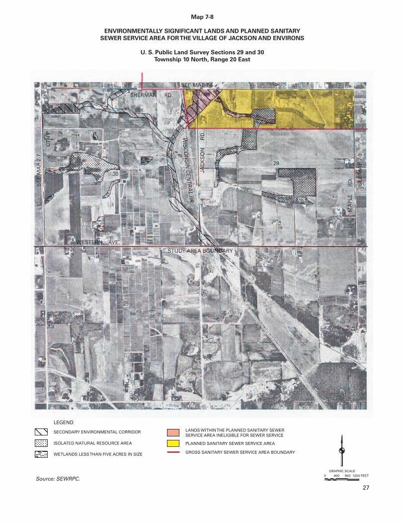
7-8 Environmentally Significant Lands and Planned Sanitary Sewer Service Area for the Village of Jackson and Environs, U. S. Public Land Survey Sections 29 and 30, Township 10 North, Range 20 East ....................................................................... 27
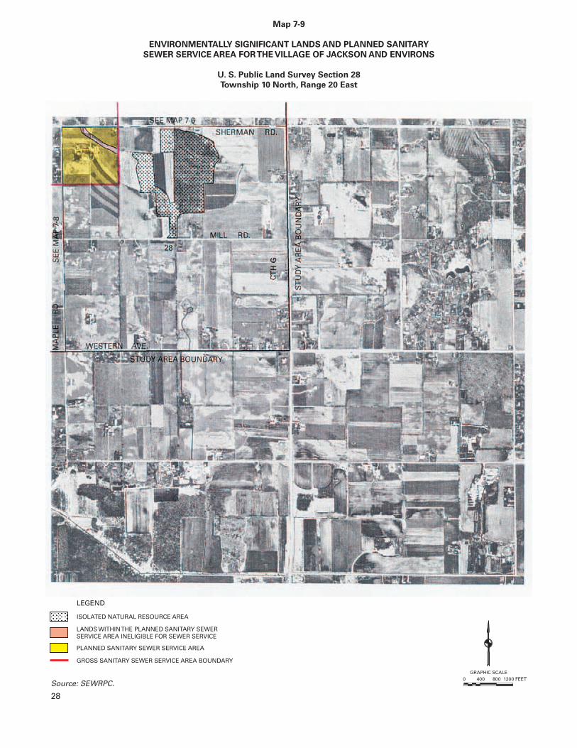
7-9 Environmentally Significant Lands and Planned Sanitary Sewer Service Area for the Village of Jackson and Environs, U. S. Public Land Survey Section 28, Township 10 North, Range 20 East .................................................................................... 28
4
LEGEND
Z
GRAPHIC SCALE
0 1 MILE
0 1200 2400 3600 FEET
12
14
G
G
P
PP
NN
P
P
CCEDAR
CREEK
WEST BEND
POLK
PO
LK
MAYFIELD
JACKSON
CEDAR
CR
EE
K
CR
EE
K
CED
AR
19
16
7 8
9
65 4
17
18
20 21
11 12
2
1
1314
24
23
26 2530
2928
60 60
41
45
HASMER
LAKE
TILLY
LAKE
JA
CK
SO
N
MILL RD
SHERMAN RDSHERMAN RD
PLEASANT
WISC
ON
SINC
ENTR
AL
LTD.
R.R
.
RD
CEDAR CREEK RD
CEDAR CREEK RD
MAY
FIEL
D
RD
MAY
FIEL
D
RD
MA
PLE
R
D
MA
PLE
R
D
JAC
KS
ON
R
D
Map 2
STUDY AREA IDENTIFIED FOR PURPOSES OF REFINING AND
DETAILING THE VILLAGE OF JACKSON SANITARY SEWER SERVICE AREA
Source: SEWRPC.
WILDLIFE
Z
T 11 N
R 19 E R 20 E
T 10 N
WESTERN AVE
VALLEY
1996 VILLAGE OF JACKSON CIVIL DIVISION BOUNDARY
JACKSON
MARSH
AREA
6
LTD.
Source: SEWRPC.
T 11 N
R 19 E R 20 E
T 10 N
PP
NN
P
8
1996 VILLAGE OF JACKSONCIVIL DIVISION BOUNDARY
LEGEND
GRAPHIC SCALE
0 1 MILE
0 1200 2400 3600 FEET
12
14
Map 3
ENVIRONMENTALLY SIGNIFICANT LANDS IN THE VILLAGE OF JACKSON STUDY AREA
G
G
P
P
Z
CCEDAR
CREEK
WEST BEND
POLK
PO
LK
MAYFIELD
JACKSON
CEDAR
CR
EE
K
CR
EE
K
CED
AR
19
16
7 8
9
6 5 4
17
18
20 21
11 12
2
1
1314
2423
26 2530
2928
60 60
41
45
HASMER
LAKE
TILLY
LAKE
JA
CK
SO
N
MILL RD
SHERMAN RDSHERMAN RD
PLEASANT
WISC
ON
SINC
ENTR
AL
R.R
.
RD
CEDAR CREEK RD
CEDAR CREEK RD
MAY
FIEL
D
RD
MAY
FIEL
D
RD
MA
PLE
R
D
MA
PLE
R
D
JAC
KS
ON
R
D
Z
WESTERN AVE
VALLEY
PRIMARY ENVIRONMENTAL CORRIDOR
ISOLATED NATURAL RESOURCE AREA
WETLANDS LESS THANFIVE ACRES IN SIZE
SECONDARY ENVIRONMENTAL CORRIDOR
JACKSON
WILDLIFE
MARSH
AREA
10
LTD.
Source: SEWRPC.
T 11 N
R 19 E R 20 E
T 10 N
1996 VILLAGE OF JACKSON CIVIL DIVISION BOUNDARY
LEGEND
VILLAGE OF JACKSON SEWER SERVICE AREA AS DEFINED IN SEWRPCCOMMUNITY ASSISTANCE PLANNING REPORT NO. 124 (1ST EDITION)
GRAPHIC SCALE
0 1 MILE
0 1200 2400 3600 FEET
12
14
G
G
P
P
Z
CCEDAR
CREEK
WEST BEND
POLK
PO
LK
MAYFIELD
JACKSON
CEDAR
CR
EE
K
CR
EE
K
CED
AR
19
16
7 8
9
65 4
17
18
20 21
11 12
2
1
1314
24
23
26 2530
2928
60 60
41
45
HASMER
LAKE
TILLY
LAKE
JA
CK
SO
N
MILL RD
SHERMAN RDSHERMAN RD
PLEASANT
WISC
ON
SINC
ENTR
AL
R.R
.
RD
CEDAR CREEK RD
CEDAR CREEK RD
MAY
FIEL
D
RD
MAY
FIEL
D
RD
MA
PLE
R
D
MA
PLE
R
D
JAC
KS
ON
R
D
Map 4
VILLAGE OF JACKSON SANITARY SEWER SERVICE AREA AS DEFINED
IN SEWRPC COMMUNITY ASSISTANCE PLANNING REPORT NO. 124
JACKSON
WILDLIFE
MARSH
Z
WESTERN AVE
VALLEYPP
NN
P
12
AREA
14
WETLANDS LESS THANFIVE ACRES IN SIZE
LEGEND
GRAPHIC SCALE
0 1 MILE
0 1200 2400 3600 FEET
12
14
Map 5
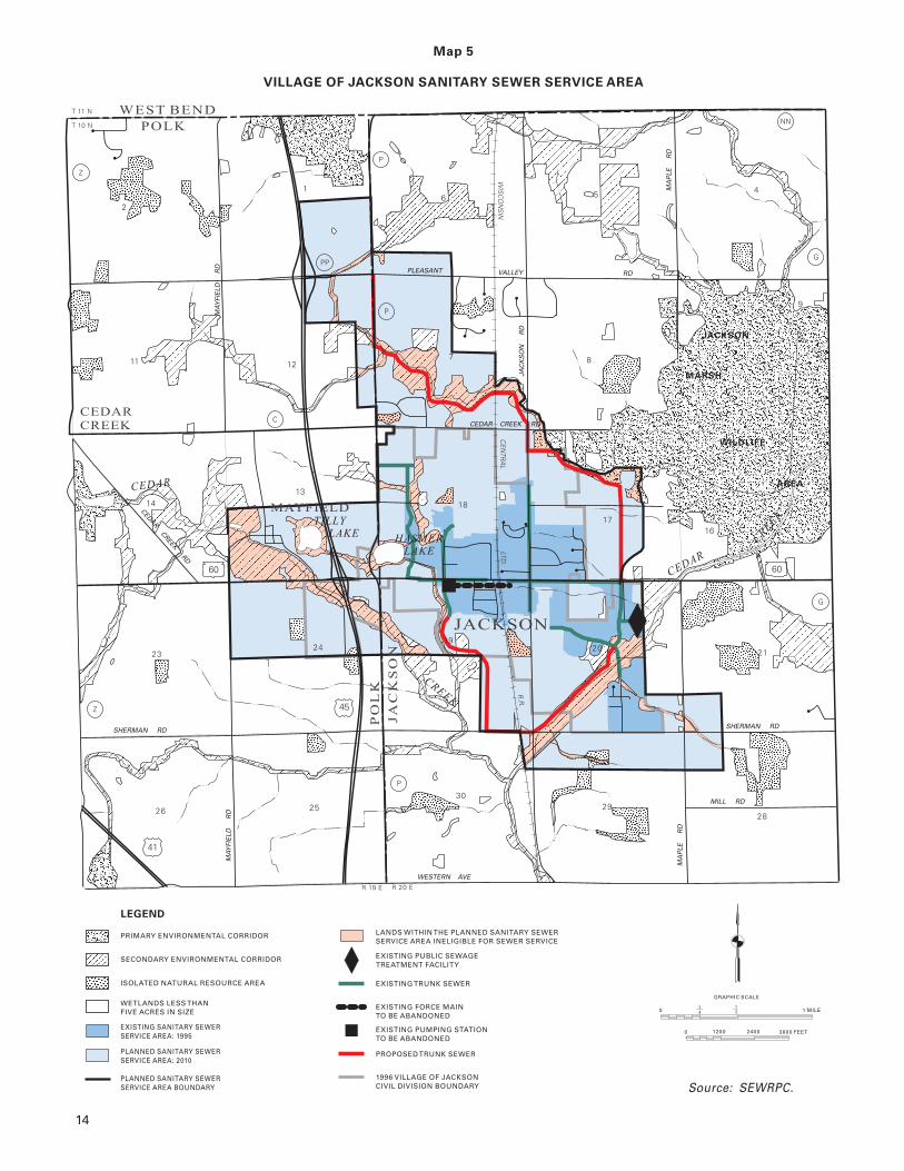
VILLAGE OF JACKSON SANITARY SEWER SERVICE AREA
Source: SEWRPC.
G
G
NN
PP
P
P
P
CCEDAR
CREEK
WEST BEND
POLK
PO
LK
CR
EE
K
CED
AR
16
7 8
9
64
17
18
20 21
11 12
2
1
1314
2423
26 2530
2928
60 60
41
45
JA
CK
SO
N
MILL RD
SHERMAN RDSHERMAN RD
PLEASANT
WISC
ON
SINC
ENTR
AL
LTD.
R.R
.
RD
MAY
FIEL
D
RD
MA
PLE
R
D
MA
PLE
R
D
JAC
KS
ON
R
D
Z
T 11 N
R 19 E R 20 E
T 10 N
WESTERN AVE
VALLEY
PRIMARY ENVIRONMENTAL CORRIDOR
EXISTING PUBLIC SEWAGETREATMENT FACILITY
LANDS WITHIN THE PLANNED SANITARY SEWERSERVICE AREA INELIGIBLE FOR SEWER SERVICE
EXISTING PUMPING STATIONTO BE ABANDONED
EXISTING TRUNK SEWER
PROPOSED TRUNK SEWER
1996 VILLAGE OF JACKSONCIVIL DIVISION BOUNDARY
EXISTING FORCE MAINTO BE ABANDONED
ISOLATED NATURAL RESOURCE AREA
EXISTING SANITARY SEWERSERVICE AREA: 1995
PLANNED SANITARY SEWERSERVICE AREA: 2010
PLANNED SANITARY SEWERSERVICE AREA BOUNDARY
SECONDARY ENVIRONMENTAL CORRIDOR
JACKSON
WILDLIFE
MARSH
Z
19
MAYFIELD
TILLY
LAKE
CEDAR CREEK RD
CEDAR CREEK RD
MAY
FIEL
D
RD
HASMER
LAKE
AREA
CR
EE
K
CEDAR
JACKSON
5
LTD.
T 11 N
R 19 E R 20 E
T 10 N NN
PP
P
GRAPHIC SCALE
0 1 MILE
0 1200 2400 3600 FEET
12
14
LEGEND
Map 6
ANTICIPATED CHANGES IN THE ENVIRONMENTALLY SIGNIFICANT LANDS
IN THE VILLAGE OF JACKSON SANITARY SEWER SERVICE AREA: 1995-2010
Source: SEWRPC.
G
G
P
P
Z
CCEDAR
CREEK
WEST BEND
POLK
PO
LK
JACKSON
CEDAR
CR
EE
K
CR
EE
K
CED
AR
19
16
7 8
9
6 54
17
18
20 21
11 12
2
1
1314
2423
26 2530
2928
60 60
41
45
HASMER
LAKE
TILLY
LAKE
MILL RD
SHERMAN RDSHERMAN RD
WISC
ON
SINC
ENTR
AL
R.R
.
RD
CEDAR CREEK RD
MAY
FIEL
D
RD
MAY
FIEL
D
RD
MA
PLE
R
D
MA
PLE
R
D
JAC
KS
ON
R
D
Z
WESTERN AVE
VALLEY
PRIMARY ENVIRONMENTAL CORRIDOR
FLOODLANDS PROPOSED TO REMAIN UNDEVELOPEDAND ADDED TO THE SECONDARY ENVIRONMENTALCORRIDOR
ISOLATED NATURAL RESOURCE AREA
WETLANDS LESS THANFIVE ACRES IN SIZE
GROSS SANITARY SEWER SERVICE AREA BOUNDARY
1996 VILLAGE OF JACKSON CIVIL DIVISION BOUNDARY
FLOODLANDS LOCATED OUTSIDE THEJACKSON SEWER SERVICE AREA WHICH WOULDBE INCLUDED IN THE ADJACENT ENVIRONMENTALCORRIDOR SHOULD THE SEWER SERVICE AREABE EXPANDED
PORTION OF EXISTING ISOLATED NATURAL RESOURCEAREA ANTICIPATED TO BE RECLASSIFIED ASSECONDARY ENVIRONMENTAL CORRIDOR
SECONDARY ENVIRONMENTAL CORRIDOR
AREAS OF DISTURBED TOPOGRAPHY --LIMITS OF FLOODLAND UNDETERMINED
JACKSON
WILDLIFE
MARSH
PLEASANT
CEDAR CREEK RD
MAYFIELD
16
JA
CK
SO
N
AREA
Z
GRAPHIC SCALE
0 1 MILE
0 1200 2400 3600 FEET
12
14
G
G
P
PP
NN
P
P
CCEDAR
CREEK
WEST BEND
POLK
PO
LK
MAYFIELD
JACKSON
CEDAR
CR
EE
K
CR
EE
K
CED
AR
19
16
7 8
9
65 4
17
18
20 21
11 12
2
1
1314
24
23
26 2530
2928
60 60
41
45
HASMER
LAKE
TILLY
LAKE
JA
CK
SO
N
MILL RD
SHERMAN RDSHERMAN RD
PLEASANT
WISC
ON
SINC
ENTR
AL
LTD.
R.R
.
RD
CEDAR CREEK RD
CEDAR CREEK RD
MAY
FIEL
D
RD
MAY
FIEL
D
RD
MA
PLE
R
D
MA
PLE
R
D
JAC
KS
ON
R
D
Map 7
INDEX OF MAPS SHOWING ENVIRONMENTALLY SIGNIFICANT LANDS AND PLANNED
THE VILLAGE OF JACKSON AND ENVIRONSSANITARY SEWER SERVICE AREA FOR
Source: SEWRPC.
WILDLIFE
Z
T 11 N
R 19 E R 20 E
T 10 N
WESTERN AVE
VALLEY
JACKSON
MARSH
AREA
19
7-1 7-2 7-3
7-4 7-5 7-6
7-7
7-87-9
Map 7-1
ENVIRONMENTALLY SIGNIFICANT LANDS AND PLANNED SANITARY
SEWER SERVICE AREA FORTHE VILLAGE OF JACKSON AND ENVIRONS
U. S. Public Land Survey Sections 1, 2, 11, and 12
Township 10 North, Range 19 East
WETLANDS LESSTHAN FIVE ACRES IN SIZE
GROSS SANITARY SEWER SERVICE AREA BOUNDARY
PLANNED SANITARY SEWER SERVICE AREA
LANDS WITHINTHE PLANNED SANITARY SEWERSERVICE AREA INELIGIBLE FOR SEWER SERVICE
ISOLATED NATURAL RESOURCE AREA
SECONDARY ENVIRONMENTAL CORRIDOR
PRIMARY ENVIRONMENTAL CORRIDOR
LEGEND
GRAPHIC SCALE0 400 800 1200 FEET
Source: SEWRPC.
20
WETLANDS LESSTHAN FIVE ACRES IN SIZE
GROSS SANITARY SEWER SERVICE AREA BOUNDARY
PLANNED SANITARY SEWER SERVICE AREA
LANDS WITHINTHE PLANNED SANITARY SEWERSERVICE AREA INELIGIBLE FOR SEWER SERVICE
ISOLATED NATURAL RESOURCE AREA
SECONDARY ENVIRONMENTAL CORRIDOR
PRIMARY ENVIRONMENTAL CORRIDOR
LEGEND
Map 7-2
ENVIRONMENTALLY SIGNIFICANT LANDS AND PLANNED SANITARY
SEWER SERVICE AREA FORTHE VILLAGE OF JACKSON AND ENVIRONS
U. S. Public Land Survey Sections 5, 6, 7, and 8
Township 10 North, Range 20 East
GRAPHIC SCALE0 400 800 1200 FEET
Source: SEWRPC.
21
Map 7-3
ENVIRONMENTALLY SIGNIFICANT LANDS AND PLANNED SANITARY
SEWER SERVICE AREA FORTHE VILLAGE OF JACKSON AND ENVIRONS
U. S. Public Land Survey Sections 4 and 9
Township 10 North, Range 20 East
WETLANDS LESSTHAN FIVE ACRES IN SIZE
ISOLATED NATURAL RESOURCE AREA
SECONDARY ENVIRONMENTAL CORRIDOR
PRIMARY ENVIRONMENTAL CORRIDOR
LEGEND
GRAPHIC SCALE0 400 800 1200 FEET
Source: SEWRPC.
22
Map 7-4
ENVIRONMENTALLY SIGNIFICANT LANDS AND PLANNED SANITARY
SEWER SERVICE AREA FORTHE VILLAGE OF JACKSON AND ENVIRONS
U. S. Public Land Survey Sections 13, 14, 23 and 24
Township 10 North, Range 19 East
WETLANDS LESSTHAN FIVE ACRES IN SIZE
GROSS SANITARY SEWER SERVICE AREA BOUNDARY
PLANNED SANITARY SEWER SERVICE AREA
LANDS WITHINTHE PLANNED SANITARY SEWERSERVICE AREA INELIGIBLE FOR SEWER SERVICE
ISOLATED NATURAL RESOURCE AREA
SECONDARY ENVIRONMENTAL CORRIDOR
PRIMARY ENVIRONMENTAL CORRIDOR
LEGEND
GRAPHIC SCALE0 400 800 1200 FEET
Source: SEWRPC.
23
Map 7-5
ENVIRONMENTALLY SIGNIFICANT LANDS AND PLANNED SANITARY
SEWER SERVICE AREA FORTHE VILLAGE OF JACKSON AND ENVIRONS
U. S. Public Land Survey Sections 17, 18, 19, and 20
Township 10 North, Range 20 East
WETLANDS LESSTHAN FIVE ACRES IN SIZE
GROSS SANITARY SEWER SERVICE AREA BOUNDARY
PLANNED SANITARY SEWER SERVICE AREA
LANDS WITHINTHE PLANNED SANITARY SEWERSERVICE AREA INELIGIBLE FOR SEWER SERVICE
ISOLATED NATURAL RESOURCE AREA
SECONDARY ENVIRONMENTAL CORRIDOR
PRIMARY ENVIRONMENTAL CORRIDOR
LEGEND
GRAPHIC SCALE0 400 800 1200 FEET
Source: SEWRPC.
24
Map 7-6
ENVIRONMENTALLY SIGNIFICANT LANDS AND PLANNED SANITARY
SEWER SERVICE AREA FORTHE VILLAGE OF JACKSON AND ENVIRONS
U. S. Public Land Survey Sections 16 and 21
Township 10 North, Range 20 East
WETLANDS LESSTHAN FIVE ACRES IN SIZE
GROSS SANITARY SEWER SERVICE AREA BOUNDARY
PLANNED SANITARY SEWER SERVICE AREA
LANDS WITHINTHE PLANNED SANITARY SEWERSERVICE AREA INELIGIBLE FOR SEWER SERVICE
ISOLATED NATURAL RESOURCE AREA
SECONDARY ENVIRONMENTAL CORRIDOR
PRIMARY ENVIRONMENTAL CORRIDOR
LEGEND
GRAPHIC SCALE0 400 800 1200 FEET
Source: SEWRPC.
25
Map 7-7
ENVIRONMENTALLY SIGNIFICANT LANDS AND PLANNED SANITARY
SEWER SERVICE AREA FORTHE VILLAGE OF JACKSON AND ENVIRONS
U. S. Public Land Survey Sections 25 and 26
Township 10 North, Range 19 East
WETLANDS LESSTHAN FIVE ACRES IN SIZE
ISOLATED NATURAL RESOURCE AREA
SECONDARY ENVIRONMENTAL CORRIDOR
PRIMARY ENVIRONMENTAL CORRIDOR
LEGEND
GRAPHIC SCALE0 400 800 1200 FEET
Source: SEWRPC.
26
Map 7-8
ENVIRONMENTALLY SIGNIFICANT LANDS AND PLANNED SANITARY
SEWER SERVICE AREA FORTHE VILLAGE OF JACKSON AND ENVIRONS
U. S. Public Land Survey Sections 29 and 30
Township 10 North, Range 20 East
WETLANDS LESSTHAN FIVE ACRES IN SIZE GROSS SANITARY SEWER SERVICE AREA BOUNDARY
PLANNED SANITARY SEWER SERVICE AREA
LANDS WITHINTHE PLANNED SANITARY SEWERSERVICE AREA INELIGIBLE FOR SEWER SERVICE
ISOLATED NATURAL RESOURCE AREA
SECONDARY ENVIRONMENTAL CORRIDOR
LEGEND
GRAPHIC SCALE0 400 800 1200 FEET
Source: SEWRPC.
27
Map 7-9
ENVIRONMENTALLY SIGNIFICANT LANDS AND PLANNED SANITARY
SEWER SERVICE AREA FORTHE VILLAGE OF JACKSON AND ENVIRONS
U. S. Public Land Survey Section 28
Township 10 North, Range 20 East
ISOLATED NATURAL RESOURCE AREA
LEGEND
GRAPHIC SCALE0 400 800 1200 FEET
Source: SEWRPC.
28
GROSS SANITARY SEWER SERVICE AREA BOUNDARY
PLANNED SANITARY SEWER SERVICE AREA
LANDS WITHINTHE PLANNED SANITARY SEWERSERVICE AREA INELIGIBLE FOR SEWER SERVICE
APPENDIX
31
Appendix A
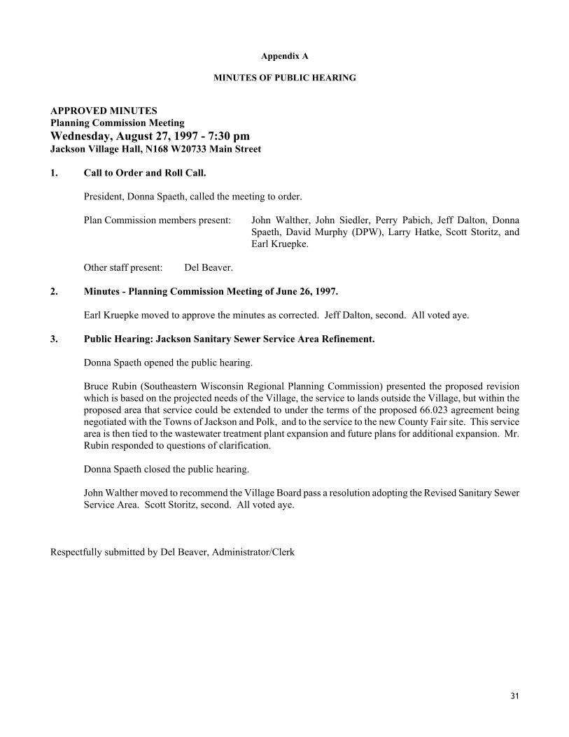
MINUTES OF PUBLIC HEARING APPROVED MINUTES Planning Commission Meeting Wednesday, August 27, 1997 - 7:30 pm Jackson Village Hall, N168 W20733 Main Street 1. Call to Order and Roll Call.
President, Donna Spaeth, called the meeting to order.
Plan Commission members present: John Walther, John Siedler, Perry Pabich, Jeff Dalton, Donna Spaeth, David Murphy (DPW), Larry Hatke, Scott Storitz, and Earl Kruepke.
Other staff present: Del Beaver.
2. Minutes - Planning Commission Meeting of June 26, 1997.
Earl Kruepke moved to approve the minutes as corrected. Jeff Dalton, second. All voted aye. 3. Public Hearing: Jackson Sanitary Sewer Service Area Refinement.
Donna Spaeth opened the public hearing.
Bruce Rubin (Southeastern Wisconsin Regional Planning Commission) presented the proposed revision which is based on the projected needs of the Village, the service to lands outside the Village, but within the proposed area that service could be extended to under the terms of the proposed 66.023 agreement being negotiated with the Towns of Jackson and Polk, and to the service to the new County Fair site. This service area is then tied to the wastewater treatment plant expansion and future plans for additional expansion. Mr. Rubin responded to questions of clarification.
Donna Spaeth closed the public hearing.
John Walther moved to recommend the Village Board pass a resolution adopting the Revised Sanitary Sewer Service Area. Scott Storitz, second. All voted aye.
Respectfully submitted by Del Beaver, Administrator/Clerk