STATE OF CALIFORNIA CALIFORNIA NATURAL RESOURCES AGENCY CALIFORNIA FISH AND GAME COMMISSION MITIGATED NEGATIVE DECLARATION FOR SANTA BARBARA MARICULTURE COMPANY CONTINUED SHELLFISH AQUACULTURE OPERATIONS ON STATE WATER BOTTOM LEASE OFFSHORE SANTA BARBARA, CALIFORNIA Prepared By: California Fish and Game Commission Staff This Report has been prepared pursuant to the California Environmental Quality Act of 1970 State of California California Natural Resources Agency California Fish and Game Commission January 2018
Transcript
STATE OF CALIFORNIA
CALIFORNIA NATURAL RESOURCES AGENCY
CALIFORNIA FISH AND GAME COMMISSION
MITIGATED NEGATIVE DECLARATION
FOR
SANTA BARBARA MARICULTURE COMPANY
CONTINUED SHELLFISH AQUACULTURE OPERATIONS
ON
STATE WATER BOTTOM LEASE
OFFSHORE SANTA BARBARA, CALIFORNIA
Prepared By:
California Fish and Game Commission Staff
This Report has been prepared pursuant to the
California Environmental Quality Act of 1970
State of California
California Natural Resources Agency
California Fish and Game Commission
January 2018
THIS PAGE INTENTIONALLY LEFT BLANK
INITIAL STUDY
AND
MITIGATED NEGATIVE DECLARATION
FOR
Santa Barbara Mariculture Company
Continued Shellfish Aquaculture Operations
On State Water Bottom Lease
Offshore Santa Barbara, California
Project Overview: Since 2005, Santa Barbara Mariculture Company (SBMC) has been
culturing shellfish on a state water bottom lease issued by the Fish and Game Commission
(FGC) as Lease No. M-653-02, a 72-acre area with an average water depth of 80 feet located
approximately 0.75 miles from the coast of Santa Barbara.
The Project would modify the position of the existing 72-acre leased state water bottom through
a 26-acre reduction in the deepest portion of the existing parcel and addition of a new parcel of
equal size, sited adjacent (northwest) to the existing farm, to create a narrower configuration and
a net result of two adjacent parcels totaling 72 acres using the same culture gear to cultivate the
same species currently employed.
Approximately 25 acres of the current lease area are in continuous mussel and intermittent oyster
production using 12 longlines. If approved, the Project will result in adding 28 new longlines for
a total of 40 longlines across the combined, newly configured 72-acre lease.
The Finding: Although the projects may have the potential to cause minor short-term impacts on
biological resources, as outlined in the initial study and environmental checklist, the measures
that shall be incorporated into the project will lessen such impacts to a level that is less than
significant (see initial study, specifically the environmental checklist, and Appendix L).
Basis for the Finding: Based on the initial study, it was determined there would be no
significant adverse environmental effects resulting from implementing the proposed project.
The FGC finds that implementing the proposed projects will have no significant environmental
impact. Therefore, this mitigated negative declaration is filed pursuant to the California
Environmental Quality Act (CEQA), Public Resources Code § 21080 (c2). This proposed
mitigated negative declaration consists of this project overview, findings, and basis for the
findings, and the attached Initial Study, which analyzes the environmental impacts that might
result from implementation of the proposed Project, and serves to address the potential
environmental impacts that may occur.
THIS PAGE INTENTIONALLY LEFT BLANK
Initial Study
Project: Santa Barbara Mariculture Company Continued Shellfish
Aquaculture Operations on State Water Bottom Lease Offshore
Section 3. Environmental Factors Potentially Affected and Determination ................................................ 10
Section 4. Initial Study Environmental Checklist, Discussion, and Expalantion of Response to
Findings ............................................................................................................................................................. 12 4.1 Resource Areas Dismissed from Detailed Analysis ............................................................................. 12 4.2 Aesthetics ............................................................................................................................................. 13 4.3 Air Quality............................................................................................................................................ 15 4.4 Biological Resources ............................................................................................................................ 18 4.5 Cultural Resources ............................................................................................................................... 37 4.5a Tribal Cultural Resources .................................................................................................................... 38 4.6 Geology and Soils ................................................................................................................................ 38 4.7 Greenhouse Gas Emissions .................................................................................................................. 40 4.8 Hazards and Hazardous Materials ........................................................................................................ 42 4.9 Hydrology and Water Quality .............................................................................................................. 44 4.10 Land Use and Planning ......................................................................................................................... 48 4.11 Noise .................................................................................................................................................... 49 4.12 Recreation............................................................................................................................................. 51 4.13 Transportation/Traffic .......................................................................................................................... 52 4.14 Utilities and Service Systems ............................................................................................................... 55 4.15 Mandatory Findings of Significance .................................................................................................... 57
Section 5. List of Preparers .............................................................................................................................. 59
Map 3. Substrate of SBMC Lease and Surrounding Area ................................................................... 21
LIST OF TABLES Table 2-1. Summary of Lease Components and Capacities........................................................................ 4 Table 4.3-1. Proposed Project Estimated Daily Maximum and Annual Total Emissions from
Commercial Passenger Fishing Vessels for SBCAPCD* .................................................... 16 Table 4.4-1. Results of Sediment Grain Size Analyses in Farmed and Unfarmed Areas. ........................... 19 Table 4.4-2. Average Number of Benthic Infauna Species by Taxonomic Group in Farmed and
LIST OF DIAGRAMS Diagram 1. Existing Longline Configuration .............................................................................................. 4
LIST OF FIGURES Figure 1. Anchor Possibilities of New Lease ............................................................................................ 5
Figure 2. Mussels Hanging from the Backbone ........................................................................................ 7
Figure 3. Recovery of Oyster Mesh Net ................................................................................................... 7
LIST OF APPENDICES Appendix A. SBMC Equipment List
Appendix A1. Longline Engineering Analysis
Appendix A2. Weather and Oceanographic Data – UNH Tests vs. Santa Barbara Channel Conditions
Appendix B. Letter from Researcher Carol Blanchette Discussing Introduced Mussel Species
Appendix C. Quality Standard Certificate for Whole Foods Market
Appendix C1. Whole Foods Market Quality Standard for Farmed Bivalve Molluscs
Appendix D. List of Agencies Involved in Entire Permitting Process
Appendix E. Proposed Project Estimated Emissions
Appendix F. Phytoplankton Population Impact Statement and Calculation
Appendix G. Benthic Sampling Data
Appendix H. Benthic Infaunal Taxonomy Data
Appendix I. SBMC Lease Inspections and Bottom Surveys
Appendix J. EFH Species Potentially Present within the SBMC Offshore Shellfish Farm Project Area.
Appendix K. Santa Barbara Mariculture Spill and Response Plan
Appendix L. Potentially significant impacts and corresponding mitigation measures related to the Proposed
Project
Initial Study
Santa Barbara Mariculture Offshore Farm
Contents iii January 2018
ACRONYMS AND ABBREVIATIONS
CAPCOA California Air Pollution Controls Officers Association
CDFW California Department of Fish and Wildlife
CEQA California Environmental Quality Act
CPS Coastal Pelagic Species
CNDDB Natural Diversity Database
EFH Essential Fish Habitat
EIR Environmental Impact Report
FGC California Fish and Game Commission
GHG Green House Gasses
HCP Habitat Conservation Plan
HMS Highly Migratory Species
MND Mitigated Negative Declaration
PCG Pacific Coastal Groundfish
SCB Southern California Bight
SBCAPCD Santa Barbara County Air Pollution Control District
SBMC Santa Barbara Mariculture Company
SCCAB South Central Coast Air Basin
US United States
Initial Study
Santa Barbara Mariculture Offshore Farm
Section 2: Project Description 1 January 2018
SECTION 1. BACKGROUND
1.1 Summary
Project Title: Santa Barbara Mariculture Company Continued Shellfish
Aquaculture Operations on State Water Bottom Lease
Offshore Santa Barbara, California
Lead Agency Name and Address: California Fish and Game Commission P.O. Box 944209
Sacramento, CA 94244-2090
Contact Person and Phone Number: Valerie Termini, Executive Director,
(916) 653-4899
Project Location:
Project Sponsor’s Name & Address
Leased state water bottom located 0.75 mile offshore from
the coast of Santa Barbara, California
Bernard Friedman
Santa Barbara Mariculture Company
4365 Cuna Drive
Santa Barbara, CA 93110
General Plan Designation: Not Applicable
Zoning: Not Applicable
1.2 Introduction
The California Fish and Game Commission (FGC) is the Lead Agency for this Initial Study. The Initial Study has
been prepared to identify and assess the anticipated environmental impacts of the proposed Santa Barbara
Mariculture Company continued shellfish aquaculture operations offshore from Santa Barbara, California (the
Project) on a reconfigured and renewed state water bottom lease (#M-653-02) and new adjacent plot. This
document has been prepared to satisfy the California Environmental Quality Act (CEQA) (Pub. Res. Code, Section
21000 et seq.) and State CEQA Guidelines (14 CCR 15000 et seq.). CEQA requires that all state and local
government agencies consider the environmental consequences of Projects over which they have discretionary
authority before acting on those Projects. Approval of the Project is a discretionary action of FGC. A CEQA Initial
Study is generally used to determine which CEQA document is appropriate for a Project (Negative Declaration,
Mitigated Negative Declaration, or Environmental Impact Report [EIR]).
Background: Since 2005, Santa Barbara Mariculture Company (SBMC) has been culturing shellfish on a state
water bottom lease issued by FGC as Lease No. M-653-02, a 72-acre area with an average water depth of 80 feet
located approximately 0.75 miles from the coast of Santa Barbara (Map 1), although SBMC’s predecessors in
interest began culturing shellfish at this site beginning in 1984.
This Initial Study is in reference to a proposed change in the existing 72-acre leased state water bottoms established
for shellfish cultivation, through a 26-acre reduction in the deepest portion of the existing parcel and addition of a
new parcel of equal size, sited adjacent (northwest) to the existing farm, to create a narrower configuration and a
net result of two adjacent parcels totaling 72 acres (see Map 2). The existing lease has been in operation for over
twelve years using the same culture gear to cultivate the same species as the proposed Project.
Approximately 25 acres of the 72 acre lease area (M-653-02) are in continuous mussel and intermittent oyster
production using 12 longlines. If approved, the Project will result in adding 28 new longlines to the existing 12
longlines to a total of 40 longlines across the combined, newly configured 72-acre lease (see Table 2-1).
Initial Study
Santa Barbara Mariculture Offshore Farm
Section 2: Project Description 2 January 2018
Map 2. New proposed lease location.
Map 1: Project Vicinity
SBMC Lease
Initial Study
Santa Barbara Mariculture Offshore Farm
Section 2: Project Description 3 January 2018
SECTION 2. PROJECT DESCRIPTION
2.1 Project Objective
The objective of the Project is to continue and expand mussel and oyster production on a newly configured,
narrower 72-acre shellfish farm lease. The goal is to site the long axis of this lease roughly parallel with the coast
and within ocean depths between 70 to 100 feet, making the anchorages and lines accessible by divers. This depth
and orientation would also make the lease more operationally compatible to the operator’s cultivation and harvest
activities, and reduce conflicts with other marine users such as boat traffic. The Project would enable increased
utilization of the lease area for active shellfish production.
2.2 Proposed Project
Background of Existing Lease M-653-02
Santa Barbara Mariculture Company (SBMC) is the current leaseholder of state water bottom lease #M-653-02,
issued by FGC. This lease was originally established by Mr. Jeffrey Young, owner of Pacific Seafood Industries
(PSI), in 1984 as a one-acre parcel for shellfish production. It was amended by FGC to a 78-acre lease in 1986, and
further amended to its current configuration of 72 acres in 1996. In 2005, FGC approved transfer of the lease to
SBMC. An amendment to the lease was approved by FGC in December 2014 to correct the location description in
the lease using updated GPS coordinates.
Application for Revised Lease Configuration
In June 2013, SBMC requested that FGC renew the existing 72-acre lease with a modified lease footprint. The
modified footprint would result from relocating the deepest 26 acre portion of the lease area to an area adjacent to
the remaining more shallow lease area, to result in a more narrowly configured lease operation along the same
approximate depth contours with no net change in total acreage.
In consultation with FGC and CDFW staff, it was determined that such a shape transformation would require two
discretionary administrative actions: a renewal of the existing lease (M-653-02) covering a parcel size reduced by
26 acres (to 46 acres), and approval of a new 26-acre lease parcel adjacent to the reduced existing lease parcel.
Taken together, these two areas would result in the more narrowly-configured 72 acre area authorized for shellfish
cultivation.
For purposes of CEQA, this document is analyzing all changes from the existing shellfish growing operation in the
portion of lease M-653-02 currently utilized to the final, reconfigured 72-acre lease area when fully utilized (see
Map 2).
A summary of the existing and new lease components and capacities is provided in Table 2-1.
2.3 Project Characteristics
2.3.1 Shellfish Farm: Culture Methods and Species
Current Offshore Submerged Longline System. The offshore farm operation currently occupies about a 25-acre
footprint within the current 72-acre lease (M-653-02), and has a total of 12 longlines that are used to farm oysters and
mussels. Four 6-foot-high spar buoys with radar reflective material inside delineate the four corners of the farm.
Proposed: The proposed reconfigured lease area will be farmed using similar practices as, and be integrated with, the
immediately adjacent existing operations (Map 2 and Table 2-1). The design of the longline and culture gear would
also be the same as for the existing longlines, with some modifications of anchoring systems.
Initial Study
Santa Barbara Mariculture Offshore Farm
Section 2: Project Description 4 January 2018
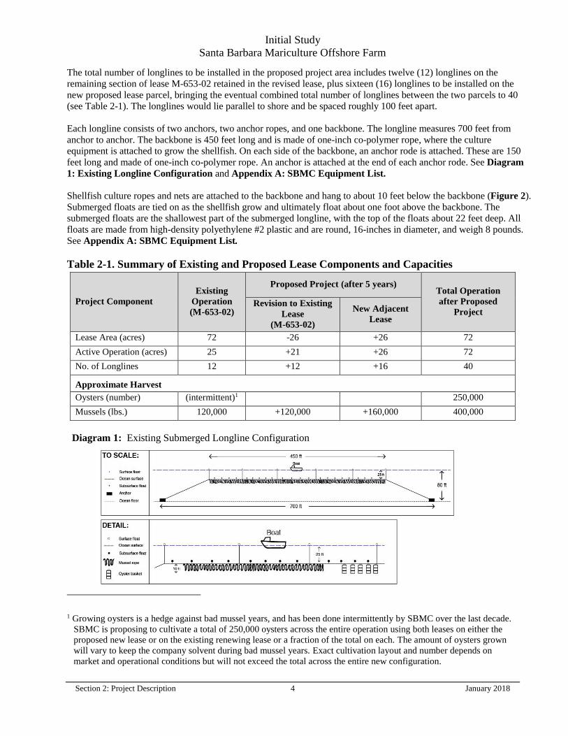
The total number of longlines to be installed in the proposed project area includes twelve (12) longlines on the
remaining section of lease M-653-02 retained in the revised lease, plus sixteen (16) longlines to be installed on the
new proposed lease parcel, bringing the eventual combined total number of longlines between the two parcels to 40
(see Table 2-1). The longlines would lie parallel to shore and be spaced roughly 100 feet apart.
Each longline consists of two anchors, two anchor ropes, and one backbone. The longline measures 700 feet from
anchor to anchor. The backbone is 450 feet long and is made of one-inch co-polymer rope, where the culture
equipment is attached to grow the shellfish. On each side of the backbone, an anchor rode is attached. These are 150
feet long and made of one-inch co-polymer rope. An anchor is attached at the end of each anchor rode. See Diagram
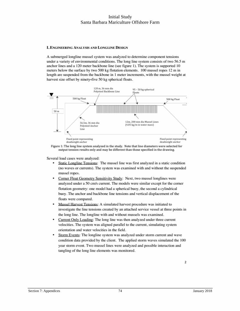
1: Existing Longline Configuration and Appendix A: SBMC Equipment List.
Shellfish culture ropes and nets are attached to the backbone and hang to about 10 feet below the backbone (Figure 2).
Submerged floats are tied on as the shellfish grow and ultimately float about one foot above the backbone. The
submerged floats are the shallowest part of the submerged longline, with the top of the floats about 22 feet deep. All
floats are made from high-density polyethylene #2 plastic and are round, 16-inches in diameter, and weigh 8 pounds.
See Appendix A: SBMC Equipment List.
Table 2-1. Summary of Existing and Proposed Lease Components and Capacities
1 Growing oysters is a hedge against bad mussel years, and has been done intermittently by SBMC over the last decade.
SBMC is proposing to cultivate a total of 250,000 oysters across the entire operation using both leases on either the
proposed new lease or on the existing renewing lease or a fraction of the total on each. The amount of oysters grown
will vary to keep the company solvent during bad mussel years. Exact cultivation layout and number depends on
market and operational conditions but will not exceed the total across the entire new configuration.
Initial Study
Santa Barbara Mariculture Offshore Farm
Section 2: Project Description 5 January 2018
Longline Configuration
Anchors and floats. On the existing lease (M-653-02), twenty (20) of the anchors are made of concrete with a
geometric shape approximately 3 feet long, 4 feet wide, and 2 feet high, weighing approximately 1 ton. The other
four (4) anchors on the existing lease are 100-kilogram metal fluke anchors. An additional cement clump weight of
120 pounds, ten feet from the anchor, acts as a motion dampener. The backbone (the part of the longline to which
the mussels and oysters are attached) also has a 120 pound clump weight on each end, which extends to the ocean
floor with 0.5 inch co-polymer rope and a counter float (16-inch submersible), stabilizing the longline and giving it
its shape. Six, 16-inch surface floats are also attached to the backbone with 0.5-inch co-polymer rope to stabilize
the backbone at 25 feet below the surface.
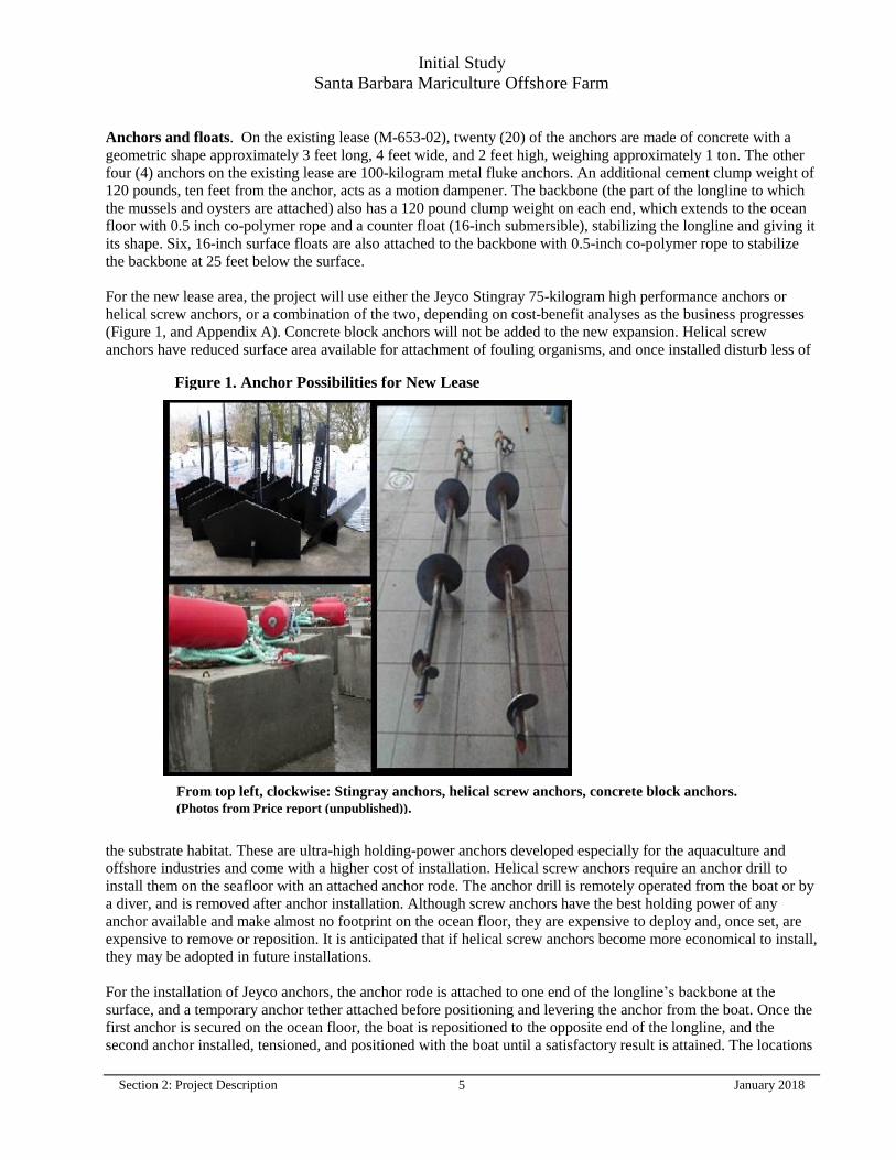
For the new lease area, the project will use either the Jeyco Stingray 75-kilogram high performance anchors or
helical screw anchors, or a combination of the two, depending on cost-benefit analyses as the business progresses
(Figure 1, and Appendix A). Concrete block anchors will not be added to the new expansion. Helical screw
anchors have reduced surface area available for attachment of fouling organisms, and once installed disturb less of
the substrate habitat. These are ultra-high holding-power anchors developed especially for the aquaculture and
offshore industries and come with a higher cost of installation. Helical screw anchors require an anchor drill to
install them on the seafloor with an attached anchor rode. The anchor drill is remotely operated from the boat or by
a diver, and is removed after anchor installation. Although screw anchors have the best holding power of any
anchor available and make almost no footprint on the ocean floor, they are expensive to deploy and, once set, are
expensive to remove or reposition. It is anticipated that if helical screw anchors become more economical to install,
they may be adopted in future installations.
For the installation of Jeyco anchors, the anchor rode is attached to one end of the longline’s backbone at the
surface, and a temporary anchor tether attached before positioning and levering the anchor from the boat. Once the
first anchor is secured on the ocean floor, the boat is repositioned to the opposite end of the longline, and the
second anchor installed, tensioned, and positioned with the boat until a satisfactory result is attained. The locations
Figure 1. Anchor Possibilities for New Lease
From top left, clockwise: Stingray anchors, helical screw anchors, concrete block anchors.
(Photos from Price report (unpublished)).
Initial Study
Santa Barbara Mariculture Offshore Farm
Section 2: Project Description 6 January 2018
of the anchors are determined by a global positioning system (GPS) on board the boat. Until helical screw anchors
become more economical, Jeyco anchors have been shown to perform satisfactorily and will likely be used for the
Proposed Project initially.
Structural engineering analysis and field performance. The longline system used by SBMC in the existing
lease area, and proposed in the new project, closely parallels designs tested by the University of New Hampshire’s
Atlantic Marine Aquaculture Center (UNH). UNH deployed longlines and grew mussels on their system in an open
ocean environment five miles off the coast of New Hampshire and collected extensive data on the structural
performance of these longlines.
According to Dr. Richard Langdon, Director of Coastal and Ocean Technology Programs at UNH, his team of
engineers has monitored its offshore longlines for 10 years which have “survived without failure at least 30
Nor’easters, some measured significant wave heights of 40 feet and greater than 25 feet for a 72 hour
period.” Based on a decade of real world experience and sophisticated modeling, the ocean engineers at UNH
developed the “Longline Static and Dynamic Analysis Results” (see Appendix A1).
The design and length of the SBMC longline is slightly different than the one modelled by UNH, but it exhibits
similar characteristics. However, SBMC longlines will only be loaded with 10,000 lbs. of mussels instead of the
18,000 lbs. of mussels exhibited in the model; oyster longlines will only carry about 5,000 lbs. which will be a
further reduction in load. The model calculates that worst-case scenario loading with currents of 140 cm/s and
waves of 30 feet at 17 seconds produced a max tension on the anchor line of 12,868 lbs. SBMC longlines will be
carrying a lower amount of shellfish, with max loading calculated at 7,077 lbs. SBMC uses one inch ropes for its
backbone and anchor lines, which have a minimum breaking strength of 23,000 lbs., providing a built-in safety
factor of over the 3 to 1 margin recommended by UNH.
The concrete anchors built and installed on the existing operation by SBMC are of similar design and holding
characteristics to Dor-mor anchors (see photo in Appendix A). A 650 lb. Dor-mor anchor has a holding power of
6,500 lbs. SBMC utilizes one-ton concrete anchors that weigh approximately 1,100 lbs. in the water. Counting for
the displacement of the iron Dor-mor anchor, the SBMC cement anchors have a holding power of 12,000 lbs.
In 2011, two 50 kg Jeyco stingray anchors were deployed in the longline design to test its practicalities and
implementation. These anchors have a published holding power of 8.6 tons (17,200 lbs.) in sand. In 2017, they
are still working with minimal corrosion. The farm will utilize 75 kg Jeyco stingray anchors which have a
published holding power of 12 tons (24,000 lbs.) in sand. These anchors have a minimum of 3 to 1 built in safety
factor for holding the project longlines in place.
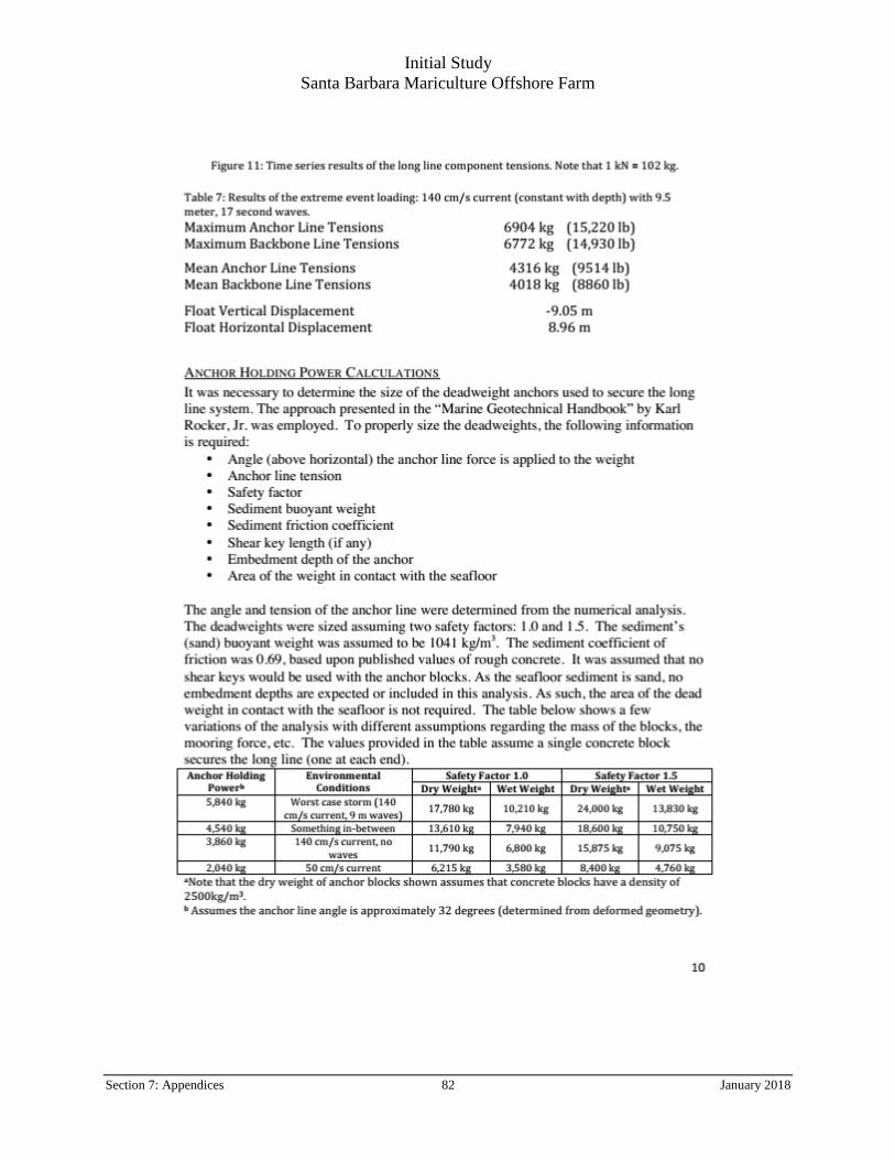
To compare the extreme weather conditions under the UNH test to local conditions, storm data was collected from
nearby weather stations2. Local recorded maximum storm events fall well within the limits described by the UNH
Longline Statistic and Dynamic Analysis Model, which analyzed storm conditions of 9.5-meter waves with 17-
second periods, and 140 cm/s currents. The data collected from nearby weather stations had lower maximum wave
heights (5 meters), longer wave periods (25 seconds), and slower currents (36.7 cm/s). The loads experienced by
SBMC culture gear would be considerably less than the loads tested in the model.
Culture species. Mediterranean mussels (Mytilus galloprovincialis) and Pacific oysters (Crassostrea gigas) are
the two species that SBMC has actively been culturing since 2005 and have been approved by CDFW under
SBMC’s Aquaculture Registration (#0969). In addition, rock scallops (Crassadoma gigantea, formerly Hinnites
multirugosus), speckled scallop (Argopectin aequisulcatus), Japanese bay scallop (Patinopectin yessoensis), Kumamoto oyster (Crassostrea sikamea), and Manila clam (Venerupis philippinarum) are all species that have
been approved by FGC for culture on the existing (M-653-02) lease. SBMC proposes no change to the previously-
2 See Appendix A2: Weather and Oceanographic Data – UNH Tests vs. Santa Barbara Channel Conditions
Initial Study
Santa Barbara Mariculture Offshore Farm
Section 2: Project Description 7 January 2018
approved lease’s complete list of species and culture methods within the terms of the newly reconfigured lease
under this Proposed Project.
2.3.2 Shellfish Farming Operations
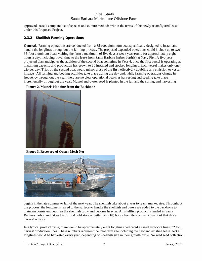
General. Farming operations are conducted from a 35-foot aluminum boat specifically designed to install and
handle the longlines throughout the farming process. The proposed expanded operations could include up to two
35-foot aluminum boats visiting the farm a maximum of five days a week year-round for approximately eight
hours a day, including travel time to the lease from Santa Barbara harbor berth(s) at Navy Pier. A five-year
projected plan anticipates the addition of the second boat sometime in Year 4, once the first vessel is operating at
maximum capacity and production has grown to 30 installed and stocked longlines. Each vessel makes only one
trip per day. Trips by the second boat would mirror those of the first, effectively doubling any emission or vessel
impacts. All farming and boating activities take place during the day and, while farming operations change in
frequency throughout the year, there are no clear operational peaks as harvesting and seeding take place
incrementally throughout the year. Mussel and oyster seed is planted in the fall and the spring, and harvesting
begins in the late summer to fall of the next year. The shellfish take about a year to reach market size. Throughout
the process, the longline is raised to the surface to handle the shellfish and buoys are added to the backbone to
maintain consistent depth as the shellfish grow and become heavier. All shellfish product is landed in Santa
Barbara harbor and taken to certified cold storage within ten (10) hours from the commencement of that day’s
harvest activity.
In a typical product cycle, there would be approximately eight longlines dedicated as seed grow-out lines, 32 for
harvest production lines. These numbers represent the total farm site including the new and existing lease. Not all
longlines would be harvested every year, depending on shellfish size in their growth cycle. No wild seed collection
Figure 2. Mussels Hanging from the Backbone
Figure 3. Recovery of Oyster Mesh Net
Initial Study
Santa Barbara Mariculture Offshore Farm
Section 2: Project Description 8 January 2018
lines will be utilized on the new or existing operations. All seed is obtained from CDFW-approved commercial
hatchery stock which is planted directly to growout lines by the hatchery (for mussels) or into hanging nets (for
oysters) by SBMC. Some lines would lie fallow between harvest and re-seeding, for varying periods of time.
Specific numbers of fallow/seed/harvest lines for the new projected lease are always in flux. Production cycles
would typically be 10 to 16 months, so there would be some overlap every year. At full operation, estimated annual
production is approximately 240,000 pounds of mussels and/or up to 250,000 oysters (counted as singles).
Mussel Farming Operations. The mussel culture begins by hanging 10-foot fuzzy ropes on the backbone. The
fuzzy ropes are obtained from a shellfish hatchery and already have settled mussels on them. Each rope can carry
as many as 50,000 mussels, which are referred to as “spat” once they are permanently attached to a surface. After 3
months, the mussel spat have grown to 0.25-inch in size; the seed ropes are stripped and the mussels are placed into
a machine that re-distributes them onto another continuous mussel rope using a biodegradable net sock to hold
them in place until the mussels attach themselves to this fuzzy rope. The mussel rope is tied and draped below the
backbone in 10-foot loops spaced 3-feet apart (Figure 2). About 2,000 feet of fuzzy rope is tied to one longline. At
harvest time, the end of the mussel rope is untied from the backbone and inserted into a ship-board harvesting
machine run by the boat’s hydraulic system. The machine strips the rope of its mussels and rotates them through
spinning brushes to break the mussels apart and clean them of any fouling. The most common fouling on mussels
is filamentous algae and barnacles, which is washed by seawater and returned to the ocean from whence it came.
Washing mussels during harvesting is recommended by the National Shellfish Sanitation Program (FDA, National
Shellfish Sanitation Program, 2013). After passing through the machine, the mussels are transferred into a barrel of
seawater before being placed onto a sorting table. The market-size mussels are rinsed and placed into 25-pound
bags and stored in barrels of seawater for transport back to landing, and undersized mussels collected for re-
attachment to ropes for continued grow-out.
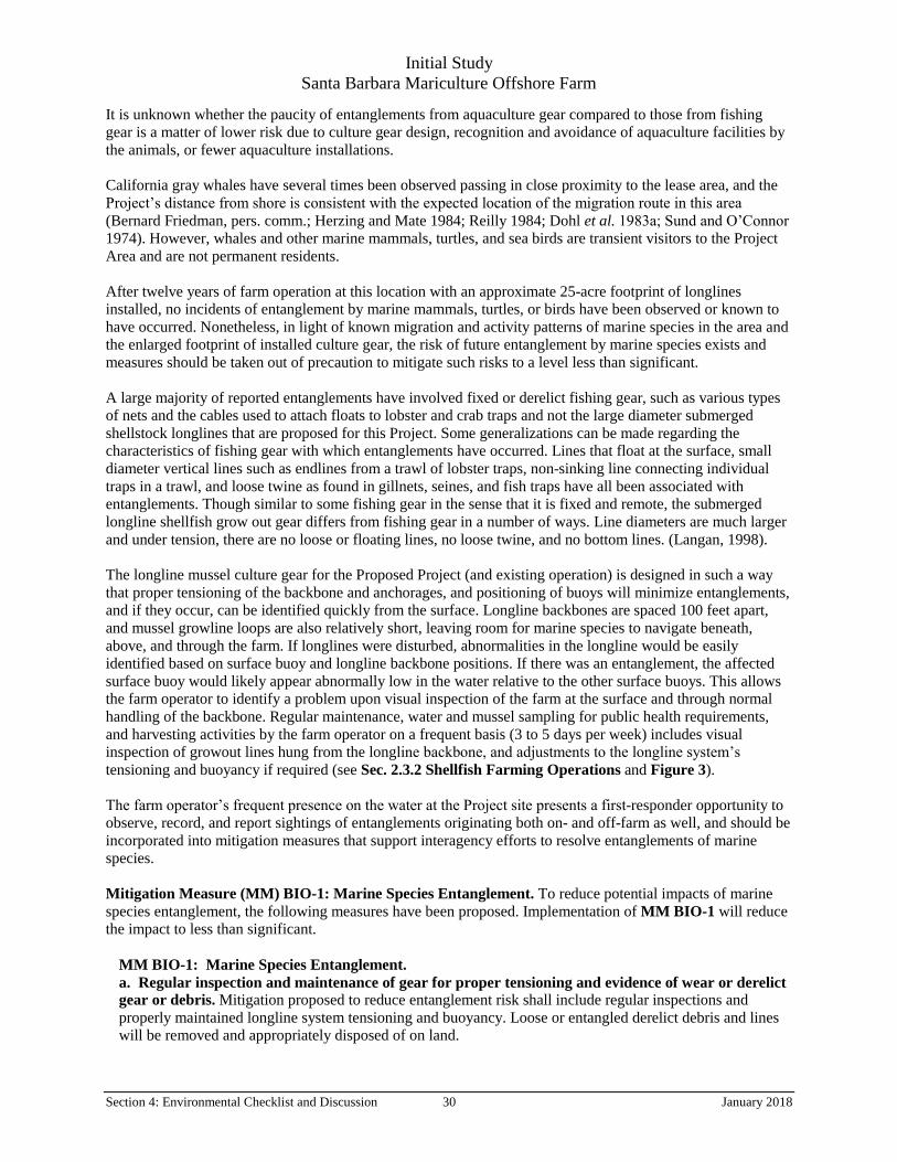
Oyster Farming Operations. The culture of oysters begins by placing 0.25-inch oysters into 6-millimeter mesh
nets hung from the longline backbone, and are transferred into larger 12-mm mesh nets as they grow (see Figure
3). The oysters reside in a net for no longer than 4 months. Four hundred market-sized oysters can be grown in a
net. During harvest, oyster nets are brought onto the boat and dumped on deck (Figure 3). The oysters are shoveled
onto the sorting table where the market-sized oysters are counted and placed into trays. The undersized oysters are
placed back into the net for further growth. The market-sized oysters are washed with seawater and placed into
mesh bags for market. After transfer or harvest, each used oyster net is cleaned on board, and then stored on land
until the next crop cycle (approximately 120 nets in total). The mesh nets are pressured cleaned on the deck using a
hydraulic pump (using Mobile EAL 224H non-toxic and biodegradable hydraulic oil) and hose using ocean water.
2.4 Project Timing
The Proposed Project, including the existing and new lease areas, would enter to full production at the end of a 5-
year period of development. Year 1 would consist of installation of 16 longlines on the new lease (and 8 new
longlines on the existing lease). This Year 1 installation of these 24 new longlines would take a total of 16 days,
spread over the course of three to six months, accounting for weather and other scheduling concerns. Year 2 and 3
would consist of installing the remaining four new longlines. Year 4 would consist of the addition of another boat
to support increased production. Year 5 would consist of full production at the target of 400,000 pounds of mussels
and/or 250,000 oysters on both leases.
Initial Study
Santa Barbara Mariculture Offshore Farm
Section 2: Project Description 9 January 2018
2.5 Regulatory Requirements, Permits, and Approvals
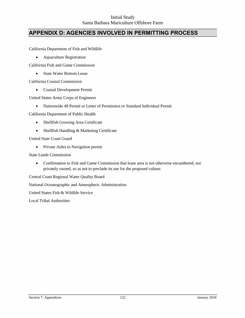
The following approvals and regulatory permits would be required for implementation of the Proposed Project.
(See Appendix D for expanded list).
AGENCY PERMIT TYPES
California Department of Fish and Wildlife Aquaculture Registration
California Fish and Game Commission State Water Bottom Lease
California Coastal Commission Coastal Development Permit
United States Army Corp of Engineers Nationwide 48 permit or Letter of
Permission or Standard Individual Permit
(at the discretion of USACE)
United States Coast Guard Private Aid to Navigation permit
California Department of Public Health Shellfish Growing Area Certificate, and
Shellfish Handling & Marketing Certificate
Initial Study
Santa Barbara Mariculture Offshore Farm
Section 3: Environmental Factors Potentially Affected 10 January 2018
SECTION 3. ENVIRONMENTAL FACTORS POTENTIALLY AFFECTED AND DETERMINATION
This section contains the Initial Study that was completed in accordance with the requirements of CEQA for
the proposed project known as “Reconfiguration of offshore State Water Bottom Lease held by Santa Barbara
Mariculture Company relating to M-653-02” (Proposed Project). The Initial Study identifies site-specific
conditions and impacts, evaluates their potential significance, and discusses ways to avoid or lessen impacts
that are potentially significant. The information, analysis and conclusions included in the Initial Study provide
the basis for determining the appropriate document needed to comply with CEQA.
The evaluation of environmental impacts provided in this Initial Study is based in part on the impact questions
contained in Appendix G of the State CEQA Guidelines; these questions, which are included in an impact
assessment matrix for each environmental category (Aesthetics, Air Quality, Biological Resources, etc.), are
“intended to encourage thoughtful assessment of impacts.” Each question is followed by a check-marked box
with column headings that are defined below.
• Potentially Significant Impact. This column is checked if there is substantial evidence that a Project-related
environmental effect may be significant. If there are one or more “Potentially Significant Impacts,” a Project
Environmental Impact Report (EIR) would be prepared.
• Less than Significant with Mitigation. This column is checked when the Project may result in a significant
environmental impact, but the incorporation of identified Project revisions or mitigation measures would
reduce the identified effect(s) to a less than significant level.
• Less than Significant Impact. This column is checked when the Project would not result in any significant
effects. The Project’s impact is less than significant even without the incorporation of Project-specific
mitigation measures.
• No Impact. This column is checked when the Project would not result in any impact in the category or the
category does not apply.
Initial Study
Santa Barbara Mariculture Offshore Farm
Section 3: Environmental Factors Potentially Affected 11 January 2018
For this Project, based on the analysis and information contained herein, the FGC has found that the Initial
Study shows that there is substantial evidence that the Project may have a significant effect on the environment
but revisions to the Project would avoid the effects or mitigate the effects to a point where clearly no
significant effect on the environment would occur.
The environmental factors checked below would be potentially affected by this Project; a checked box indicates
that at least one impact would be a “Potentially Significant Impact” except that SBMC has agreed to Project
revisions, including the implementation of mitigation measures, that reduce the impact to “Less than Significant
with Mitigation.”
Aesthetics Greenhouse Gas Emissions Population and Housing
Agriculture and Forestry Resources Hazards/Hazardous Materials Public Services
Air Quality Hydrology/Water Quality Recreation
Biological Resources Land Use and Planning Transportation/Traffic
Cultural Resources Mineral Resources Utilities and Service Systems
Geology and Soils Noise Mandatory Findings of Significance
Agency Determination
Based on the environmental impact analysis provided by this Initial Study:
I find that the Project COULD NOT have a significant effect on the environment, and a NEGATIVE
DECLARATION will be prepared.
I find that although the Project could have a significant effect on the environment, there will not be a
significant effect in this case because revisions in the project have been made by or agreed to by the project
proponent. A MITIGATED NEGATIVE DECLARATION will be prepared.
I find that the Project MAY have a significant effect on the environment, and an ENVIRONMENTAL
IMPACT REPORT is required.
I find that the Project MAY have a “potentially significant impact” or “potentially significant unless
mitigated” impact on the environment but at least one effect 1) has been adequately analyzed in an earlier
document pursuant to applicable legal standards, and 2) has been addressed by mitigation measures based
on the earlier analysis as described on attached sheets. An ENVIRONMENTAL IMPACT REPORT is
required, but it must analyze only the effects that remain to be addressed.
I find that although the Project could have a significant effect on the environment, because all potentially
significant effects (a) have been analyzed adequately in an earlier EIR or NEGATIVE DECLARATION
pursuant to applicable standards, and (b) have been avoided or mitigated pursuant to that earlier EIR or
NEGATIVE DECLARATION, including revisions or mitigation measures that are imposed upon the
Project, nothing further is required.
01/05/2018
Signature Date
Valerie Termini, Executive Director
California Fish and Game Commission
Initial Study
Santa Barbara Mariculture Offshore Farm
Section 4: Environmental Checklist and Discussion 12 January 2018
SECTION 4. INITIAL STUDY ENVIRONMENTAL CHECKLIST AND DISCUSSION
4.1 Resource Areas Dismissed from Detailed Analysis
The following resources are unlikely to be significantly affected by the Project and therefore will not be
considered further in this document.
Agriculture and Forestry Resources
The Project site is located in the Pacific Ocean. Other than the aquacultural activities of the Project itself3, there
are no other agricultural or forest land uses near the project site, and it is not located on soils that are identified
by the California Resources Agency as Prime Farmland, Unique Farmland, or Farmland of Statewide Importance
because it is located in the Pacific Ocean. The Project site is not zoned for, nor prohibited from agricultural use,
is not subject to a Williamson Act contract, and is not zoned for forest land, timberland, or timberland production.
Population and Housing
The Project would not induce substantial population growth in the area, either directly or indirectly, nor would
it displace housing or people, and thereby not require replacement housing. The reconfiguration of the lease may
result in growth of the operation’s workforce by an insignificant magnitude in terms of local population and
housing requirements (less than ten new workers).
Public Services
The Project would not result in adverse impacts to fire or police protection services, schools, parks, or other
public facilities, and would comply with all local regulations. It would not require additional fire or police
services beyond those needed for the current operation.
Mineral Resources
The Proposed Project would not result in the loss of any mineral resources, nor any foreseeable loss of mineral
resource recovery sites. Although the Santa Barbara Channel is known for its oil and gas resources, the State
Lands Commission has not issued a new offshore oil development lease in nearly 50 years, and no such leases
exist near the Proposed Project area. Modern drilling technologies would not preclude access to such
underground, offshore resources beneath the Proposed Project, should public concern and policies toward new
oil and gas development change.
3 Several California statutes recognize “aquaculture” as “agriculture”. Definitions for “aquaculture” in both Fish and
Game Code (Sec. 17) and Food and Agriculture Code, or FAC, (Sec. 25.5) refer to aquaculture as a form of
agriculture. FAC further states (Sec. 23.5) that: “…the commercial production of that fish and marine life shall be
considered a branch of the agricultural industry of the State for the purpose of any law which provides for the
benefit or protection of the agricultural industry of the State except those laws relating to plant quarantine or pest
control.”
Initial Study
Santa Barbara Mariculture Offshore Farm
Section 4: Environmental Checklist and Discussion 13 January 2018
4.2 Aesthetics
AESTHETICS – Would the project:
Potentially
Significant
Impact
Less than
Significant
with
Mitigation
Incorporated
Less than
Significant
Impact
No
Impact
a) Have a substantial adverse effect on a scenic
vista?
b) Substantially damage scenic resources,
including, but not limited to, trees, rock
outcroppings, and historic buildings within a
state scenic highway?
c) Substantially degrade the existing visual
character or quality of the site and its
surroundings?
d) Create a new source of substantial light or
glare, which would adversely affect day or
nighttime views in the area?
4.2.1 Environmental Setting
Regional Setting
The City of Santa Barbara is located in southern Santa Barbara County between the Santa Ynez Mountains and
the Pacific Ocean. It is bordered by the City of Goleta and the unincorporated community of Toro Canyon. The
City of Santa Barbara has expansive views of both the mountains and the sea (City of Santa Barbara, 2011).
Visual Setting - Onshore
Santa Barbara has a temperate Mediterranean climate with an abundance of trees and vegetation. The City has
a small community feel, with an easily accessible downtown area, numerous parks, museums, and miles of
beaches (City of Santa Barbara, 2011).
State Scenic Highways. The California Scenic Highway Program protects and enhances the scenic beauty of
California’s highways and adjacent corridors. A highway can be designated as scenic based on how much
natural beauty can be seen by users of the highway, the quality of the scenic landscape, and if development
impacts the enjoyment of the view (Caltrans, 2014). Santa Barbara has one Officially Designated State Scenic
Highway, State Highway 154, known as San Marcos Pass Road. United States (US) Highway 101 is
designated as an Eligible State Scenic Highway.
Visual Setting - Offshore Project Site
The Proposed Project site is located in the Pacific Ocean approximately one mile southwest from Arroyo Burro
Beach County Park. The Proposed Project would be underwater except for a) five spar buoys above the surface
demarcating the Proposed Project; b) the boat used for both the installation of the longlines and the farming of
the shellfish; and c) approximately 96 surface buoys that sit, at most, 16 inches out of the water. The five spar buoys sit approximately 7 feet from the ocean surface and are 1 ½ inches wide, while the fifth is approximately
3 feet high and 9 inches wide. The radar reflective buoy marker is three feet above the water surface and is 9
Initial Study
Santa Barbara Mariculture Offshore Farm
Section 4: Environmental Checklist and Discussion 14 January 2018
inches in diameter. The buoys cannot be seen from the public access beach at Arroyo Burro Beach Country
Park but may be seen from the edge of the cliff at Hope Ranch, but it does not rise to the level of significance.
On most days, the buoys are not visible and no complaints or inquiries have ever surfaced in the twelve years
of operations. The southern end of State Highway 154 is located approximately three miles north of the Project
site. The view from State Highway 154 to the Project site is obstructed by a hill. US Highway 101 is located
approximately two and a half miles to the northeast of the project site.
4.2.2 Impact Analysis - Aesthetics
a) Have a substantial adverse effect on a scenic vista?
Less than Significant Impact. The Project site is primarily submerged in the Pacific Ocean except for the
five surface-visible spar buoys used as necessary for aids to navigation (four buoys are 7 feet high above
surface and the fifth buoy is three feet high), and the ninety six surface buoys. The Proposed Project would be
built directly south of the Santa Barbara coast and would not obstruct long distance views from any public
viewing areas. Equipment loading activities at Navy pier would be consistent with existing uses. Impacts to
scenic vistas would be less than significant.
b) Substantially damage scenic resources, including, but not limited to, trees, rock outcroppings, and
historic buildings within a state scenic highway?
c) Substantially degrade the existing visual character or quality of the site and its surroundings?
d) Create a new source of substantial light or glare, which would adversely affect day or nighttime views in
the area?
b – d) No Impact. No scenic resources such as trees, rock outcroppings, or historic buildings within a state
scenic highway would be damaged. The Proposed Project would not change or degrade the existing visual
character or quality of the site or its surroundings. The Project includes no nighttime operations and would not
create a new source of substantial light or glare.
Mitigation Summary
No significant impacts were identified, and no mitigation measures are required.
Initial Study
Santa Barbara Mariculture Offshore Farm
Section 4: Environmental Checklist and Discussion 15 January 2018
4.3 Air Quality
AIR QUALITY – Would the project:
Potentially
Significant
Impact
Less than
Significant
with
Mitigation
Incorporated
Less than
Significant
Impact
No
Impact
a) Conflict with or obstruct implementation of
the applicable air quality plan?
b) Violate any air quality standard or contribute
substantially to an existing or projected air
quality violation?
c) Result in a cumulatively considerable net
increase of any criteria pollutant for which
the project region is non-attainment under an
applicable federal or state ambient air quality
standard (including releasing emissions
which exceed quantitative thresholds for
ozone precursors)?
d) Expose sensitive receptors to substantial
pollutant concentrations?
e) Would the project create objectionable odors
affecting a substantial number of people?
4.3.1 Environmental and Regulatory Setting
The Proposed Project is located in the South Central Coast Air Basin (SCCAB) and is under the jurisdiction of
the Santa Barbara County Air Pollution Control District (SBCAPCD). It is the responsibility of SBCAPCD to
ensure that state and federal ambient air quality standards are achieved and maintained in the SCCAB. These
standards were established to protect sensitive receptors (i.e.: people who have an increased sensitivity to air
pollution or environmental contaminants, and may include, but are not limited to: residents of hospitals,
schools, daycare facilities, elderly housing and convalescent facilities) from adverse health impacts due to
exposure to air pollution.
Initial Study
Santa Barbara Mariculture Offshore Farm
Section 4: Environmental Checklist and Discussion 16 January 2018
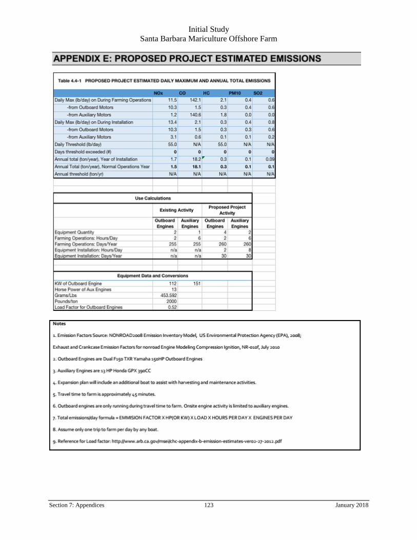
Table 4.3-1. Proposed Project estimated daily maximum and annual total emissions from
commercial passenger fishing vessels under thresholds set by SBCAPCD*
Table 4.3-1 FINAL PROPOSED PROJECT ESTIMATED DAILY MAXIMUM AND ANNUAL TOTAL EMISSIONS
NOx CO HC PM10 SO2
Daily Max (lb/day) on During Farming Operations 11.5 142.1 2.1 0.4 0.6
-from Outboard Motors 10.3 1.5 0.3 0.4 0.6
-from Auxiliary Motors 1.2 140.6 1.8 0.0 0.0
Daily Max (lb/day) on During Installation 13.4 2.1 0.3 0.4 0.8
-from Outboard Motors 10.3 1.5 0.3 0.3 0.6
-from Auxiliary Motors 3.1 0.6 0.1 0.1 0.2
Daily Threshold (lb/day) * 55.0 N/A 55.0 N/A N/A
Days Threshold exceeded (#) 0 0 0 0 0
Annual Total (ton/year), Year of Installation 1.7 18.2 0.3 0.1 0
Annual Total (ton/year), Normal Operations Year 1.5 18.1 0.3 0.1 0.1
Annual Threshold (ton/yr) N/A N/A N/A N/A N/A
Usage Data for Emissions Calculations. (see Appendix E for calculation details)
Existing Activity Proposed Project Activity
Outboard Engines
Auxiliary Engines
Outboard Engines
Auxiliary Engines
Equipment Quantity 2 1 4 2
Farming Operations: Hours/Day 2 6 2 6
Farming Operations: Days/Year 255 255 260 260
Equipment Installation: Hours/Day n/a n/a 2 8
Equipment Installation: Days/Year n/a n/a 30 30
* Santa Barbara County Air Pollution Control District
4.3.2 Impact Analysis - Air Quality
a) Conflict with or obstruct implementation of the applicable air quality plan?
Less Than Significant Impact. The Proposed Project would consider expansion from the existing baseline
activity as of 2017, and which has been consistent for the last 12 years, and potentially increase activity
represented by the addition of a second work vessel of the same type in use now. The existing SBMC farm
consists of 12 longlines (see Table 2-1), and will be expanded to a total of 40 longlines over the next 4-5 years.
Concomitant vessel traffic would gradually increase from the current single vessel with 3-4 days of operation
to approximately five days of operation using up to a total of two vessels. Table 4.3-1 reflects the total
estimated emissions (daily and annual) of the final Proposed Project. As indicated by the Usage Data section of
Table 4.3-1, baseline (existing) emissions reflect less than half of the totals estimated above. Project operation
includes planting, harvesting, and inspection activities for approximately eight hours per day, including two
hours a day of boat travel and six hours of on-site operation using only the onboard generator. During
installation of the longlines, one pickup truck and trailer would be used to bring equipment to the existing
aquaculture vessel. The Proposed Project is not expected to produce construction or operations emissions in excess of the threshold values established by the SBCAPCD as shown in Table 4.3-1. As such, the project
would not conflict or obstruct implementation of the Draft Santa Barbara County 2013 Clean Air Plan or the
Initial Study
Santa Barbara Mariculture Offshore Farm
Section 4: Environmental Checklist and Discussion 17 January 2018
Santa Barbara portion of the California State Implementation Plan (Santa Barbara County, 2015). See
Appendix E for additional detail. Project emissions would have a less than significant impact.
b) Violate any air quality standard or contribute substantially to an existing or projected air quality
violation?
Less Than Significant Impact. Construction of the Proposed Project would cause temporary minor amounts
of air emissions related to: a) vehicle exhaust from delivery of equipment (one pickup truck per day), b) the
additional boat trips for installation of the new longlines, and c) the increase in daily traffic to the farm as
operations increase to full production. The installation activities are temporary, and both the temporary and
existing increase in vehicle activity is not expected to exceed SBCAPCD daily threshold values. Impacts
would be less than significant.
c) Result in a cumulatively considerable net increase of any criteria pollutant for which the project region
is non-attainment under an applicable federal or state ambient air quality standard (including releasing
emissions which exceed quantitative thresholds for ozone precursors)?
Less Than Significant Impact. The Proposed Project would not result in cumulatively considerable net
increase of ozone or ozone precursors (which include chemical compounds like Carbone monoxide, methane
and other hydrocarbons, and nitrogen oxides which, in the presence of solar radiation, react with other similar
compounds to form ozone). Emissions of ozone precursors from the boat engine(s) are minor and below
SDAPCD thresholds. A less than significant impact would occur.
d) Expose sensitive receptors to substantial pollutant concentrations?
Less Than Significant Impact. The predominant land use surrounding the Project area is the open Pacific
Ocean and the Navy Pier, which is zoned for commercial use. Residential land uses exist around the pier to the
north. Installation emissions would be temporary. Daily operation emissions would be similar to existing
conditions and would not exceed SBCAPCD threshold criteria; therefore, sensitive receptors are not expected
to be exposed to substantial pollutant concentrations from the Proposed Project. A less than significant impact
would occur.
e) Create objectionable odors affecting a substantial number of people?
Less Than Significant Impact. The Proposed Project would not generate objectionable odors that would
affect a substantial number of people. Car traffic, boat traffic, and shellfish offloading at the Navy Pier would
be consistent with current use. Odors would remain the same as the current operation; a less than significant
impact would occur.
Mitigation Summary
No significant impacts were identified, and no mitigation measures are required.
Initial Study
Santa Barbara Mariculture Offshore Farm
Section 4: Environmental Checklist and Discussion 18 January 2018
4.4 Biological Resources
4.4.1 Environmental Setting
Habitats and Sediment Characterization
The proposed Project area, approximately 80 feet deep, contains only soft bottom substrate. Soft bottom
habitats are the predominant habitat on the continental shelf and slope throughout the Southern California
Bight (SCB). Nearshore and offshore environments include soft-bottom habitats in areas that range from flat
expanses to slopes and basin areas. Soft-bottom habitats are more common, yet less diverse than hard-bottom
habitats at all depth zones, covering over 60 percent of the entire region. Soft-bottom species are generally
bottom-dwelling invertebrates and fishes, and many have special adaptations for the habitat, such as flattened
bodies and concealing coloration. The distribution of species in soft-bottom habitats is approximately 80
percent crustaceans, 10 percent microbenthos, 5 percent demersal fish, and 5 percent macrobenthos. In deeper
soft-bottom habitats, the population density lowers with depth, while the standing crop increases with depth;
this makes for unique species assemblages at the various depths.
Coastal and near shore marine habitats in the vicinity of the proposed lease area can be characterized as the
areas from the shoreline intertidal zone, offshore to approximately 120 feet (36 meters) water depth. These
areas typically include a variety of different habitats such as coastal salt marsh, mudflats, beaches, rocky
intertidal, sea grass, and kelp forest habitat (United States Navy, 2008) common in the SCB. The SCB hosts a
wide diversity of species, including at least 481 species of fish, 492 species of algae, 4 species of seagrass, 4
species of sea turtles, 195 species of birds, at least 33 species of cetaceans, 7 species of pinnipeds, and over
5,000 species of invertebrates. This diverse assemblage of species reflects the wide range of habitats in the
region. These habitats include the following:
Estuarine and intertidal environments: Intertidal communities, from the wash zone to the lower
intertidal zone, vary in composition and structure with tidal height and wave exposure and with
underlying geology.
Biogenic habitats, such as kelp forests and seagrass beds: Many kelp species, such as giant kelp
(Macrocystis pyrifera), create kelp forests along the coast. Giant kelp forests generally form over
rocky substrate, thus they are somewhat limited within the SCB. Seagrass habitats are extremely
productive ecosystems that support an abundant and biologically diverse assemblage of aquatic fauna.
The most common type of seagrass along the open coast is surf grass (Phyllospadix spp.), also a
flowering plant, which forms beds that fringe sandy and rocky coastline areas from the lower intertidal
zone to depths of approximately ten to fifteen feet (though maximum reported depths further from the
coast, near the Channel Islands of seagrasses in the Santa Barbara Channel have been reported down
to 78ft). Neither seagrass nor kelp beds are found within or in close proximity of the proposed Project.
Hard bottom and rocky reefs: Hard-bottom habitats (also called rocky reefs) are much less common
than soft substrata in the SCB at all depth zones, covering about seven percent of the region. Many
invertebrates such as deep sea corals, sea fans, sponges, and anemones require hard substratum for
attachment in deeper waters. No hard-bottom habitats are found within or in close proximity of the
proposed Project.
Geologic processes: Geologic processes, such as oil seeps, are not uncommon in the Santa Barbara
Channel.
A dynamic oceanographic context further increases the biological complexity of the SCB, with complicated
current patterns, upwelling, retention zones, freshwater plumes, and the interaction of warm and cold
biogeographic regimes all playing a role.
Oceanographic Currents. The California Current system influences much of the primary habitat for living
marine resources in the project area. The California Current system is constantly changing in response to
Initial Study
Santa Barbara Mariculture Offshore Farm
Section 4: Environmental Checklist and Discussion 19 January 2018
weather systems, seasonal heating and cooling processes, inter-annual episodes such as El Niño/La Niña
events, and longer-term or regional-scale climatic changes. The system has a sub-surface, poleward current
(the Davidson Current) that is often at a maximum just offshore of, and somewhat deeper than, the Outer
Continental Shelf (OCS) break. The advection of warm, high-salinity, low-nutrient and plankton-poor water
from the sub-tropics is largely responsible for the warm water flora and fauna and lower productivity
characteristic of the nearshore region south of Point Conception.
Like other eastern boundary currents, the California Current experiences extensive coastal upwelling that is
primarily driven by spring and summer winds resulting from temperature gradients between the relatively cool
sea surface and the warming continental land mass. Equatorial winds, offshore Ekman transport, and coastal
upwellings occur nearly all year off Baja California and the offshore region of Southern California; however,
within the SCB, wind velocities and offshore transport are lower and upwelling is much reduced. Wind
velocities and upwelling are variable but tend to be at a maximum in the spring to early summer in the region
between Point Conception (34.5°N) and the Oregon border (42°N).
Substrate at the Proposed Lease Area. Subtidal marine habitats within the proposed lease consist of soft
bottom habitat. See Map 3: Substrate of SBMC Lease and Surrounding Area. A characterization (physical
analyses) of the sediments in the proposed leased area and current lease (farmed and unfarmed) was conducted
in July 2014 (Appendix G). Physical testing included grain size analysis of four individual samples of
sediments from both farmed and unfarmed areas, for a total of eight samples. Samples were captured using a
Peterson Grabber. Samples were then sent to a third party lab for analysis. Physical analyses indicate the
sediments in both farmed and unfarmed areas are comprised primarily of clay, fine sand, and silts (Table 4.4-
1).
Map 3. Substrate of SBMC Lease and Surrounding Area
Initial Study
Santa Barbara Mariculture Offshore Farm
Section 4: Environmental Checklist and Discussion 20 January 2018
Table 4.4-1. Results of Sediment Grain Size Analyses in Farmed and Unfarmed Areas.
Fine Sand (0.125 to 0.25mm) 15.79 24.19 18.32 18.08 15.50 27.93 18.89 22.87
Totals: 100 100 100 100 100 100 100 100
Total Silt and Clay (0 to 0.0625mm)
43.52 25.64 43.03 38.17 39.91 22.71 32.82 27.19
*number are percentages
Statistical analyses of grain size results and species population indicated no significant difference in character
and species diversity between the sediments existing in either the farmed or the unfarmed area. Detailed results
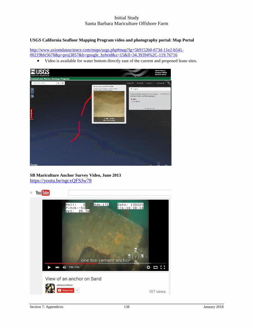
of benthic studies are presented in Appendix H. See Appendix I for inspection survey notes, photos and
linked videos of lease bottom area.
Plants
Over 75 percent of the giant kelp (Macrocystis pyrifera) ecosystems of the SCB exist within the nearshore
waters in the vicinity of the Channel Islands some 25 miles across the Channel from the proposed lease area
(Santa Barbara County 2011). No kelp is present on or immediately adjacent to the lease area. Eelgrass
(Zostera marina) beds can also be found in soft-bottom substrate along the protected shorelines off Santa
Barbara and the Channel Islands. The maximum observed depth of eelgrass was observed near the Channel
Islands at 22m deep (Engle and Miller, 2005), while the proposed lease sits in waters 24m (~80ft) deep. No
eelgrass is present in the proposed leased area. See Appendix I for links to video files and photos of the lease
bottom area.
Invertebrates
Benthic infaunal communities (aquatic animals that live in the substrate of a body of water, especially in a soft
sea bottom) within the Project Area are similar to other nearshore soft bottom habitats in Southern California
and are largely differentiated by depth and sediment grain size (Santa Barbara County 2011). Generally,
invertebrate communities that reside on and within the sediments of the mainland shelf of Southern California
are dominated by polychaetes, crustaceans, echinoderms, and mollusks (Bergen et al., 1998).
The same survey conducted in July 2014 to characterize physical sediment characteristics also was used to
characterize benthic infaunal species within the Project Area. Table 4.4-2 shows combined taxonomic groups
for the farmed and unfarmed areas sampled in the grab. Samples were captured using a Peterson Grabber. Four
sites were selected for sampling outside the farmed area in the new proposed lease area and four sample sites were selected within the bounds of the currently farmed lease. Samples were then sent to a third party lab for
analysis. Overall, the number of infauna species collected from samples in the farmed areas (all taxonomic
Initial Study
Santa Barbara Mariculture Offshore Farm
Section 4: Environmental Checklist and Discussion 21 January 2018
groups combined) ranged between 80 and 97, while unfarmed areas had 54 to 74 species. Detailed results of
benthic infaunal taxonomic analyses are presented in Appendix H: Benthic Infaunal Taxonomy Data.
Table 4.4-2. Average Number of Benthic Infaunal Species by Taxonomic Group in Farmed
and Unfarmed Areas.
Taxonomic Group Farmed Unfarmed
Annelida 36 31
Arthropoda 21 17
Mollusca 16 11
Miscellaneous 16 10
Similar to infaunal communities, epifauna species composition and abundance in the SCB, including off Santa
Barbara and the Project Area, are influenced by water depth and substrate relief. Epifauna are animals that live
on the surface of a substrate, such as rocks, pilings, marine vegetation, or a sea or lake floor. In studies
reported by the Southern California Coastal Water Research Project (SCCWRP) covering the SCB, over 200
macroinvertebrate species were collected (from all areas) during a 2008 regional monitoring effort (Allen et al., 2011). Abundances varied for specific species and localities, but the benthic assemblage is more or less
ubiquitous. Larger invertebrates found offshore over sandy bottom habitat, in the vicinity of the Project Area,
include black spotted shrimp (Crangon nigromaculata), ridgeback prawn (Sicyonia ingentis), black-tailed bay
kelletii), and paperbubble opisthobranch (Philine spp.) (SAIC 2010). Along the long expansive sandy beach
areas, the most abundant invertebrate species are common sand crab (Emerita analoga), with high densities in
the swash zone that can account for up to 98 percent of the total invertebrate macrofaunal abundance (Santa
Barbara County 2011). No federal or state-listed threatened or endangered or other special status invertebrate
species are known to be present in the Project Area.
Culture Species – Mediterranean Mussel (Mytilus galloprovincialis) and Pacific Oyster (Crassostrea gigas)
Wild mussels present along the California coast include three main species: Mytilus galloprovincialis (M.
gallo), Mytilus trossulus (M. trossulus), and Mytilus californianus (M. californianus). Another species, Mytilus
edulis (M. edulis), has historically been cited as the west coast “bay” mussel in state regulatory documents and
the scientific literature, conforming with taxonomic understanding at the time. However, M. edulis is now
recognized by taxonomists as the species found in Atlantic waters, and previous west coast references to M.
edulis are now, by convention, referring to M. trossulus or M. gallo as the west coast “bay” mussel. (Suchanek,
1997) Due to morphological similarity, distinguishing between the three mussel species making up the so-
called “M. edulis complex”: M. edulis, M. trossulus, and M. galloprovincialis, is a continuing challenge for
scientists who must rely on genetic testing to do so. The distinction is further complicated by these species’
sympatry and readiness to hybridize when found in suitable proximity for such broadcast-spawners (so-called
“hybrid zones”), and their similar ecological function (e.g.: congener filter feeders in the same habitats, with
many of the same predators and space usages). Recent studies have confounded attempts to correlate
oceanographic factors like temperature and salinity in predicting patterns of distribution and relative
competitive success of M. trossulus and M. gallo in locations defining hybrid zones along the California coast
(Babry & Somero 2006; Hilbish et al.,2010).
Although M. gallo is not originally native to California, there is abundant evidence that it is well-established
across southern California and has been present in the ecosystem since the early 1900’s. Several studies
suggest that the native bay mussel, M. trossulus was displaced by M. gallo in the early part of the twentieth
century. M. gallo is now the dominant of the two bay mussels (galloprovincialis vs. trossulus) across the entire
Initial Study
Santa Barbara Mariculture Offshore Farm
Section 4: Environmental Checklist and Discussion 22 January 2018
southern half of California. The distribution of M. gallo is restricted to more protected and sheltered habitats,
as it is not tolerant of wave exposure. Although M. gallo can be found in rocky intertidal habitats, the
California mussel, M. californianus dominates most of the rocky intertidal habitat across the entire coast of
California and is well documented to be the competitive dominant in rocky intertidal ecosystems. Not only is
M. gallo not tolerant of wave exposure, but it is also quickly consumed by a variety of predators and preferred
over M. californianus, likely due to its weaker shell. (Blanchette, pers. comm., 2014)
The Bay Mussel, and specifically, Mediterranean mussel, (M. galloprovincialis), is an approved culture species
under the terms of the existing lease with the FGC and under Aquaculture Registrations issued by the CDFW.
Bay Mussel culture has been conducted at the Proposed Project location since 2002 under State Water Bottom
Lease #M-653-02 and under the current operator’s Aquaculture Registration #0969, since 2005.
The Pacific oyster (C. gigas) is the most widely-cultivated oyster species worldwide, with west coast
aquaculture production occurring along the Pacific Ocean from Alaska to Mexico. It is an approved culture
species under the terms of the existing lease with the FGC and under Aquaculture Registrations issued by the
CDFW. Pacific oyster culture has been conducted at the Proposed Project location since 2002 under State
Water Bottom Lease #M-653-02 and under the current operator’s Aquaculture Registration #0969, since 2005.
Fishes
Over 130 species of fish were collected in the SCB during 2008 regional trawl surveys (Allen et al., 2011).
Some of the pelagic (open water) fish species common in the SBMC proposed lease area include Coastal
Pelagic Species such as northern anchovy (Engraulis mordax), Pacific sardine (Sardinops sagax), and topsmelt
(Atherinops affinis). Many of the common demersal (near the seabed) fish species found in nearshore coastal
areas include flatfishes such as California halibut (Paralichthys californicus), and other species associated with
rocky reef areas such as lingcod (Ophiodon elongatus), seaperches, white seabass (Atractoscion nobilis),
barred sand bass (Paralabrax nebulifer) and several species of rockfish (Sebastes spp.) (Santa Barbara County
2011). The shallow demersal fish community is dominated by flatfishes such as sanddabs (Citharichthys spp.),
English sole (Parophrys vetulus), rex sole (Glyptocephalus zachirus), hornyhead turbot (Pleuronectes
verticalis), and bigmouth sole (Hippoglossina stomata). Other common and abundant fish species include pink
surfperch (Zalembius rosaceus) and plainfin midshipman (Porichthys notatus). (See Appendix J for potential
fish species in the area).
The proposed lease falls within the range of the federally listed endangered Southern California Distinct
Population Segment for steelhead trout (NMFS 2011; CNDDB 2014).
Marine Birds
Birds that use the Santa Barbara Channel include sea ducks (scoters), loons, and western grebes (Santa Barbara
County 2011). In addition, the channel supports the northernmost nesting colonies for western gulls (Larus
occidentalis), California brown pelicans (Pelecanus occidentalis californicus), and Xantus’ murrelets
(Synthliboramphus hypoleucus). Coastal bird species such as grebes, cormorants, gulls, and terns make up the
greatest portion of the birds that use the Santa Barbara Channel and spend the majority of time within
approximately five miles of the shore. Other common birds that spend most of their time in offshore areas
include shearwaters (family Procellariidae), northern fulmars (Fulmarus glacialis), phalaropes (Phalaropus
spp.), jaegers, and common murres (Uria aalge) (Santa Barbara County 2011).
Marine bird species occurring in the Project Area that are protected under the California Endangered Species
Act include Xantus’ (or Scripps) murrelet. The California brown pelican has been delisted federally, but retains
protection under the federal Migratory Bird Treaty Act, and remains a fully protected species under California
Fish and Game Code (Sec. 3511.b.2). Other state bird species of special concern include the California gull
(Larus californicus) and the double-crested cormorant (Phalacrocorax auritus). These species are often
seasonal visitors to the Project Area.
Initial Study
Santa Barbara Mariculture Offshore Farm
Section 4: Environmental Checklist and Discussion 23 January 2018
Marine Mammals and Sea Turtles
More than 40 species of marine mammals use some portion of the SCB, including 34 species of cetaceans
(whales, dolphins and porpoises), six species of pinnipeds (seals and sea lions), and the southern sea otter
(Enhydra lutris nereis) (Carretta et al., 2013). These species migrate through the area on their way to calving
or feeding grounds, and are seasonal visitors for a limited time or year-round residents. The most common
marine mammals found in Project Area are California sea lions (Zalophus californianus), gray whales
(Eshrichtius robustus), blue whales (Balaenoptera musculus), as well as several dolphin and porpoise species
(Dall’s porpoise, Pacific white sided dolphin, Risso’s dolphin, and common dolphin).
In the U.S., two laws currently regulate human activities where marine mammals and turtles might be
adversely affected. These include the Marine Mammal Protection Act of 1972 (MMPA), which prohibits the
intentional taking, import, or export of any marine mammal without a permit, and the Endangered Species Act
of 1973, which extends similar protection to species listed as threatened or endangered.
Five baleen whales found in offshore areas in the vicinity of the Project Area are considered endangered under
Federal and State Endangered Species Acts. These include North Pacific right whale (Eubalaena japonica),
humpback whale (Megaptera novaeangliae), fin whale (Balaenoptera physalus), sei whale (B. borealis), and
the aforementioned blue whale. In addition, the southern sea otter population is both a federally-listed
threatened species and California fully protected species that occurs in the region (Santa Barbara County
2011). Once only observed north of Point Conception, sea otter’s range currently extends south of the Point.
The California gray whale is the most common baleen whale that passes through the project area. In 1994,
following the recovery of the stock with the cessation of commercial whaling in the first half of the 20th
century, the eastern population of gray whales in the North Pacific was removed from the list of endangered
species under the U.S. Endangered Species Act.
Most of the world’s population of gray whales passes through the Santa Barbara Channel twice each year on
their annual migration between calving grounds in Mexico and feeding grounds to the north. In contrast to
most other whale species, gray whales remain relatively close to the coastline, with the majority found close to
shore over continental shelf waters, particularly on the northbound portion of their journey (Herzing and Mate
1984; Reilly 1984; Dohl et al., 1983a; Sund and O’Connor 1974).
Gray whale migration corridors generally follow the mainland coast for much of the way. However, they
diverge south of Point Conception, with one track extending along the north side of the northern Channel
Islands and branching through the islands, and others following the coast through the channel. In general,
southbound whales stay farther offshore, while the northbound whales follow the coast more closely, at least
north of Point Conception.
Near the Project site, an inshore corridor extends seaward from just beyond the breakers. Other corridors exist
four to six nm (6.4 to 9.6 km) offshore, along the northern shores of Santa Cruz, Santa Rosa, and San Miguel
islands, and in the passages between these islands. The majority of northbound gray whales follow mid-
channel or island migration corridors (Carretta et al., 2013). However, it is expected that gray whales will
appear sporadically near the Project site, particularly during the northbound migration. Occasionally, gray
whales will stop to feed opportunistically during their migration, particularly in the spring. Whales have been
observed throughout the SCB feeding on amphipods in giant kelp beds, sand crabs (Emerita analoga) along
the surf line, and on krill (Euphasia spp.) farther offshore. The vast majority of gray whales do not linger in the
region, however, continuing their journey to the feeding grounds of the far north unabated (Santa Barbara
County 2011).
Blue and humpback whales are most commonly sighted in the western portion of the Santa Barbara Channel, especially along the shelf break north of the Channel Islands. In the Santa Barbara Channel, both species
appear during the summer months; humpbacks generally arrive in late May, and the first blue whales appear in
Initial Study
Santa Barbara Mariculture Offshore Farm
Section 4: Environmental Checklist and Discussion 24 January 2018
June. Both species remain through the summer before heading further north, to the waters off central or
northern California. Humpbacks often head farther north in late summer, sometimes reaching the Washington
coast; however, the U.S.-Canada border appears to mark the northern range limit for this stock. Regardless, the
whales generally leave California by November, although specimens are occasionally reported throughout the
year. The stock of both species winter in the waters off Central America and Mexico, where they breed and
calve. Blue and humpback whales favor escarpments and basins along the south side of the Santa Barbara
Channel and are rarely seen near the mainland coast. In the Santa Barbara Channel, humpbacks have been
observed feeding on krill (Euphasia spp.), northern anchovy (Engraulis mordax) and Pacific sardines
(Sardinops sagax caeruleus) (Santa Barbara County 2011).
Although whales are often the most highly publicized of the cetaceans found off south-central California,
seven species of porpoises actually account for the majority of the cetacean presence found in this region.
These include the Pacific white-sided dolphin (Lagenorhynchus obliquidens), the northern right whale dolphin
porpoise (Phocoena phocoena), and the two species of common dolphin. These species vary in their patterns
of usage of the area and periods of peak abundances. The two species of common dolphin (Delphinus delphis)
are by far the most abundant cetacean species off southern California, accounting for 57 to 84 percent of the
total seasonal cetacean population in the area. In contrast, Dall’s porpoises are a boreal species that only
occasionally travels as far south as the Santa Barbara Channel (Santa Barbara County 2011).
Four species of sea turtles, all of which are protected under the federal Endangered Species Act, are present in
the eastern North Pacific, including green turtles (Chelonia mydas), olive ridley turtles (Lepidochelys
olivacea), leatherback turtles (Dermochelys coriacea), and loggerhead turtles (Caretta caretta). The green,
olive ridley, and loggerhead turtles are listed as threatened species, while the leatherback is listed as an
endangered species. Although marine turtles could occur in the vicinity of the Project Area, these species are
infrequently observed and are transient visitors to the waters offshore from Santa Barbara.
4.4.2 Regulatory Setting
Federal Laws, Regulations or Policies
Federal Endangered Species Act. The Federal Endangered Species Act (ESA, 16 U.S.C. § 1531 et seq.)
protects fish and wildlife species that have been identified by the United States Fish and Wildlife Service
(USFWS) or National Oceanic and Atmospheric Administration National Marine Fisheries Service (NOAA
Fisheries) as threatened or endangered. Endangered refers to species, subspecies, or distinct population
segments that are in danger of extinction through all or a significant portion of their range. Threatened refers to
species, subspecies, or distinct population segments that are likely to become endangered in the near future.
The ESA is administered by the USFWS and NOAA Fisheries.
Marine Mammal Protection Act. All marine mammals are protected under the Marine Mammal Protection
Act (MMPA, 16 U.S.C. § 1361 et seq.). It prohibits, with certain exceptions, the take of marine mammals in
U.S. waters and by U.S. citizens on the high seas, as well as the importing of marine mammals and marine
mammal products into the U.S.
Migratory Bird Treaty Act. The Migratory Bird Treaty Act (MBTA) (16 U.S.C. § 703 et seq.) enacts the
provisions of treaties between the United States, Great Britain, Mexico, Japan, and former Soviet Union, and
authorizes the U.S. Secretary of the Interior to protect and regulate the taking of migratory birds. It establishes
seasons and bag limits for hunted species, and protects migratory birds, their occupied nests, and their eggs (16
U.S.C. § 703; 50 CFR 10, 21). Most actions that result in taking or permanent or temporary possession of a
protected species constitute violations of the MBTA. The USFWS is responsible for overseeing compliance
with the MBTA, and the U.S. Department of Agriculture’s Animal Damage Control Officer makes
recommendations on related animal protection issues. Take under the MBTA is also a state law violation (Fish
and Game Code, § 3513).
Initial Study
Santa Barbara Mariculture Offshore Farm
Section 4: Environmental Checklist and Discussion 25 January 2018
Federal Sustainable Fisheries Act. The Sustainable Fisheries Act (Public Law 104-297) of 1996 reauthorized
and amended the Magnuson Fishery Conservation and Management Act (now Magnuson-Stevens Fishery
Conservation and Management Act, 16 U.S.C. § 1801 et seq.). The Magnuson-Stevens Fishery
Conservation and Management Act (Magnuson-Stevens Act) was initially enacted in 1976 to define fisheries
jurisdiction within federal waters and create the NOAA structure for federal fisheries management. The
revisions provided in the 1996 law brought major changes to requirements for preventing overfishing and
revitalizing depleted fisheries, mostly through the scientific management and reporting conducted via fisheries
management reports
Federal West Coast Management Plans. Various federally-managed fish species in the area of the Proposed
Project come under Federal Fishery Management Plans (FMP’s), which include FMP’s for Coastal Pelagic
Species, Highly Migratory Species, and Pacific Coast Groundfish (Groundfish).
The Groundfish FMP (PFMC 2014) seeks to provide a balance between conservation, prevention of
overfishing, and maximization of the fisheries’ resources. The affected area is defined as the water column
from the surface to 400 meters depth, from the shoreline seaward to the 200-mile U.S. Exclusive Economic
Zone (EEZ) boundary for eggs and larvae, and the water column and all substrate from the shoreline to 400m
depth for juveniles and adults. The plan covers 88 species of fish, including sharks, roundfish, groundfish, and
flatfish; sets limits on harvest levels; establishes policies for periodic review and revision of regulatory
requirements and limitations; and outlines programs for rebuilding depleted stocks. Management
considerations such as licensing and permitting, size and bag limits, and net restrictions are outlined for
commercial and recreational activities.
Highly migratory species (PFMC 2011b) are fish that move great distances in the ocean to feed or reproduce.
In their migrations, they may pass through the waters of several nations and the high seas. Their presence
depends on ocean temperatures, availability of food, and other factors. Highly migratory species are sometimes
called “pelagic,” which means they do not live near the sea floor, or “oceanic,” which means they live in the
open sea. They are harvested by U.S. commercial and recreational fishers and by foreign fishing fleets. Only a
small fraction of the total harvest of most stocks is taken within U.S. waters.
Coastal Pelagic Species (PFMC 2011a). “Pelagic” means these fish live in the water column as opposed to
living near the sea floor. They can generally be found anywhere from the surface to 1,000 meters (547
fathoms) deep, and from the shoreline seaward to the EEZ boundary. Five species (Pacific sardine, Pacific
mackerel, market squid, northern anchovy, and jack mackerel) are managed under this FMP.
Essential Fish Habitat. The Magnuson-Stevens Act defines essential fish habitat (EFH) for Federal FMP
species as “those waters and substrate necessary to fish for spawning, breeding, feeding, or growth to
maturity.” NOAA Fisheries guidelines state that “adverse effects from fishing may include physical, chemical,
or biological alterations of the substrate, and loss of, or injury to, benthic organisms, prey species and their
habitat, and other components of the ecosystem.” EFH characterization is dependent upon the various species
within the Federal FMP, and by convention, have been grouped into seven composite designations: estuarine,
rocky shelf, non-rocky shelf, canyon, continental slope/basin, neritic zone, and the oceanic zone.
Habitat areas of particular concern (HAPCs) are described in the regulations as subsets of EFH that are rare,
particularly susceptible to human-induced degradation, especially ecologically important, or located in an
environmentally stressed area. These include estuaries, canopy kelp, seagrass, and rocky reef habitats.
Although designated HAPCs are not afforded additional protection under the Magnuson-Stevens Act, potential
impacts on HAPCs are considered in consultation regarding federal projects that may affect designated
HAPCs.
State and Local Laws, Regulations, or Policies
California Legislative Authority, Fish and Game Commission, Department of Fish and Wildlife. The California constitution gives authority to the State Legislature, which may, by statute, provide for the
terms and conditions under which aquaculture may be conducted. California law consists of 29 codes,
including the Fish and Game Code. Laws in the Fish and Game Code consist of statutes (chaptered bills that
Initial Study
Santa Barbara Mariculture Offshore Farm
Section 4: Environmental Checklist and Discussion 26 January 2018
have passed through both houses of the Legislature and ultimately were signed by the Governor and recorded
by the Secretary of State) and propositions passed by the voters of the state. FGC was created by the State
constitution. The rulemaking powers of FGC are delegated by the Legislature and are implemented through the
California Code of Regulations, Title 14: Natural Resources (T14 CCR).
The authority and the responsibility of FGC and CDFW to make and enforce regulations governing
aquaculture are provided by the Legislature, through Division 12 of the Fish and Game Code, particularly
section 15200, which provides that “the Commission may regulate the placing of aquatic plants and animals in
waters of the state.”
FGC regulates the sport take and possession of birds, mammals, fish, amphibians, and reptiles. FGC also
regulates aquaculture operations, including shellfish cultivation; lease of state water bottoms for aquaculture;
kelp harvest leases; and certain aspects of commercial fishing. FGC oversees the establishment of wildlife
areas and ecological reserves and regulates their use. It also prescribes the terms and conditions under which
permits or licenses may be issued by the Department and considers the revocation or suspension of commercial
and sport licenses and permits of individuals convicted of violating Fish and Game laws and regulations.
CDFW is the State agency charged with carrying out legislation, regulations, and policies adopted by the
Legislature and FGC, and is the public trustee agency that maintains the Aquaculture Coordinator; maintains
aquaculturist registrations; prohibits aquaculture operations at any location where it is determined it would be
detrimental to adjacent native wildlife; issues stocking permits; sells wild aquatic plants or animals for
aquaculture use; approves the collection of aquatic plants and animals by registered aquaculturists; designates
public areas for digging clams; processes water bottom lease applications; conducts activities relating to
aquaculture disease detection, control, and eradication; appoints an Aquaculture Disease Committee and an
Aquaculture Development Committee; establishes disease quarantines and takes related actions regarding
control and eradication; approves the importation of live aquatic plants and animals.
California Endangered Species Act. Under the California Endangered Species Act (CESA, Fish and Game
Code, §§ 2050-2116), CDFW has jurisdiction over threatened or endangered species that are formally listed by
the state. The CESA is similar to the ESA both in process and substance, with the intention of providing
additional protection to threatened and endangered species in California. The CESA does not supersede the
ESA, but operates in conjunction with it. Species may be listed as threatened or endangered under both acts, in
which case the provisions of both state and federal laws apply. Under the ESA, habitat is protected, while
under CESA it is not. Also, independent of the CESA, state law has established “fully protected” status for
certain statutorily identified birds (Fish and Game Code, § 3511), mammals (Fish and Game Code, § 4700),
reptiles and amphibians (Fish and Game Code, § 5050), and fish (Fish and Game Code, § 5515).
California Marine Life Management Act. The Marine Life Management Act (MLMA) (Assembly Bill 1241;
Statutes of 1998, Chapter 1052) was enacted to promote sustainable marine fisheries, primarily through fishery
management plans (FMPs) based on the best readily available scientific and other relevant information. Rather
than assuming that exploitation should continue until damage has become clear, the MLMA shifts the burden
of proof toward demonstrating that fisheries and other activities are sustainable. Also, rather than focusing on
single fisheries management, the MLMA requires an ecosystem perspective that includes the whole
environment.
California Statutory Policies. Various statutes express general support for aquaculture development in the
state, including the Aquaculture Development Act, which “finds and declares that it is in the interest of the
people of the state that the practice of aquaculture be encouraged...” (Pub. Resources Code, § 826 et seq.). Fish
and Game Code further declares “it is the policy of the state to encourage the conservation, maintenance, and
utilization of the living resources of the ocean and other waters under the State’s jurisdiction and influence for
the benefit of all citizens of the state…including the development of commercial aquaculture.” (Fish & GGame
Code, § 1700)
Initial Study
Santa Barbara Mariculture Offshore Farm
Section 4: Environmental Checklist and Discussion 27 January 2018
The California Coastal Commission (CCC) is a state agency established under Division 20 of the Public
Resources Code (Section 30000, et seq.) that is charged with implementing the California Coastal Act
(“Coastal Act”), the California Environmental Quality Act (CEQA), and the federal Coastal Zone Management
Act throughout California’s coastal zone. Several sections of the Coastal Act pertain specifically to
aquaculture, including the recognition of saltwater or brackish water aquaculture as a coastal-dependent use
which should be encouraged, and the protection and prioritization afforded aquaculture in land-use decisions
governed by the Coastal Act (Pub. Resources Code, §§ 30411.c, 30222.5, 30100.2).
Local Coastal Plan, other Ordinances, Santa Barbara County. Santa Barbara County’s Local Coastal Plan
(LCP) is silent with specific regard to marine aquaculture activity, with the exception of recognizing the
importance of the local commercial fishing industry, its harbor, and its support facilities, upon which the
Proposed Project depends as a harvester of marine products. The county’s LCP also points to the
aforementioned Coastal Act’s policies that prioritize coastal-dependent industries’ use and access to coastal
sites, which would include aquaculture sites. Santa Barbara County, however, does address aquaculture under
general regulations regarding planning and development, in its Article II Coastal Zoning Ordinance (Div. 7,
Sec. 35-136). Its main emphases relate to land-based visual impact minimization and compatibility with
natural surroundings.
Initial Study
Santa Barbara Mariculture Offshore Farm
Section 4: Environmental Checklist and Discussion 28 January 2018
4.4.3 Impact Analysis and Mitigation Measures - Biological Resources
BIOLOGICAL RESOURCES
Would the project:
Potentially
Significant
Impact
Less than
Significant
with
Mitigation
Incorporated
Less than
Significant
Impact
No
Impact
a) Have a substantial adverse effect, either
directly or through habitat modifications, on
any species identified as a candidate,
sensitive, or special status species in local or
regional plans, policies, or regulations, or by
the California Department of Fish and
Wildlife or U.S. Fish and Wildlife Service?
b) Have a substantial adverse effect on any
riparian habitat or other sensitive natural
community identified in local or regional
plans, policies, regulations, or by the
California Department of Fish and Wildlife
or U.S. Fish and Wildlife Service?
c) Have a substantial adverse effect on federally
protected wetlands as defined by Section 404
of the Clean Water Act (including, but not
limited to, marsh, vernal pool, coastal, etc.)
through direct removal, filling, hydrological
interruption, or other means?
d) Interfere substantially with the movement of
any native resident or migratory fish or
wildlife species or with established native
resident or migratory wildlife corridors, or
impede the use of native wildlife nursery
sites?
e) Conflict with any local policies or ordinances
protecting biological resources, such as a tree
preservation policy or ordinance?
f) Conflict with the provisions of an adopted
Habitat Conservation Plan, Natural
Community Conservation Plan, or other
approved local, regional, or state habitat
conservation plan?
Initial Study
Santa Barbara Mariculture Offshore Farm
Section 4: Environmental Checklist and Discussion 29 January 2018
Significance criteria for biological resources, contained in the Appendix G, “Environmental Checklist Form”,
of the State CEQA Guidelines have been grouped for convenient discussion in this impact analysis section,
according to both subject matter and significance of impact. Significance criteria a, b, and d are addressed in
one group of potential impacts (sub-sec. 4.4.3.1 – 4.4.3.8), while c, e, and f are addressed in a second group
reflecting No Impact by the Proposed Project. Significance determinations are indicated within each impact
sub-section (“4.4.3.X Impact BIO-X”); mitigation measures, where warranted, are described in that sub-
section (“MM-BIO-X”).
The Proposed Project would have a significant impact on biological resources if it would:
a) Have a substantial adverse effect, either directly or through habitat modifications, on any species
identified as a candidate, sensitive, or special status species in local or regional plans, policies, or
regulations, or by the California Department of Fish and Wildlife or U.S. Fish and Wildlife Service;
See discussion below under 4.4.3.7 Impact BIO-7
b) Have a substantial adverse effect on any riparian habitat or other sensitive natural community
identified in local or regional plans, policies, regulations, or by the California Department of Fish and
Wildlife or U.S. Fish and Wildlife Service;
No riparian or sensitive habitat, including kelp beds or rocky reefs, occurs within or in close proximity of
the Proposed Project.
d) Interfere substantially with the movement of any native resident or migratory fish or wildlife species or
with established native resident or migratory wildlife corridors, or impede the use of native wildlife
nursery sites.
Activities of the Proposed Project could potentially have the following impacts:
Marine species entanglements (4.4.3.1)
Aquatic invasive species spread (4.4.3.2)
Benthic impacts from cultivated animals (4.4.3.3)
Bottom disturbance from installation or structural failure of culture gear (4.4.3.4)
Marine debris (4.4.3.5)
Phytoplankton carrying capacity (4.4.3.6)
Other special status fish species interactions (4.4.3.7)
4.4.3.1 Impact BIO-1: Marine species entanglements Recent studies document entanglements involving marine mammals, particularly large baleen whales with
fishing gear (Kropp 2013), and marine species with aquaculture gear (Price et al.,2016, Young 2015). Based
on the outcome of these review studies, distinction is merited when comparing fishing vs. shellfish longline
aquaculture gear with regard to entanglements, due to their very different design and deployment, and,
importantly, the frequency of observed events globally in each case. The recently-compiled review of known
marine species interactions globally with aquaculture gear by NOAA’s National Ocean Service (Price et al.,
2016) accounts for nineteen total entanglements dating back to 1982. By contrast, fishery entanglements and
by-catch of marine mammals has been estimated in the hundreds of thousands per year (Reid et al., 2006). Of
the nineteen aquaculture-related entanglements, most involved smaller-diameter seed collection lines, which
will not be used in the Proposed Project (nor have been in the existing operation). SBMC avoids collection of
wild seed by procuring starter mussels from land-based hatcheries, where seed mussels are “pre-planted” onto
fuzzy rope growout lines (see Sec. 2.3.2 Mussel Farm Operations) for direct placement onto the farm’s
longline system.
Initial Study
Santa Barbara Mariculture Offshore Farm
Section 4: Environmental Checklist and Discussion 30 January 2018
It is unknown whether the paucity of entanglements from aquaculture gear compared to those from fishing
gear is a matter of lower risk due to culture gear design, recognition and avoidance of aquaculture facilities by
the animals, or fewer aquaculture installations.
California gray whales have several times been observed passing in close proximity to the lease area, and the
Project’s distance from shore is consistent with the expected location of the migration route in this area
(Bernard Friedman, pers. comm.; Herzing and Mate 1984; Reilly 1984; Dohl et al. 1983a; Sund and O’Connor
1974). However, whales and other marine mammals, turtles, and sea birds are transient visitors to the Project
Area and are not permanent residents.
After twelve years of farm operation at this location with an approximate 25-acre footprint of longlines
installed, no incidents of entanglement by marine mammals, turtles, or birds have been observed or known to
have occurred. Nonetheless, in light of known migration and activity patterns of marine species in the area and
the enlarged footprint of installed culture gear, the risk of future entanglement by marine species exists and
measures should be taken out of precaution to mitigate such risks to a level less than significant.
A large majority of reported entanglements have involved fixed or derelict fishing gear, such as various types
of nets and the cables used to attach floats to lobster and crab traps and not the large diameter submerged
shellstock longlines that are proposed for this Project. Some generalizations can be made regarding the
characteristics of fishing gear with which entanglements have occurred. Lines that float at the surface, small
diameter vertical lines such as endlines from a trawl of lobster traps, non-sinking line connecting individual
traps in a trawl, and loose twine as found in gillnets, seines, and fish traps have all been associated with
entanglements. Though similar to some fishing gear in the sense that it is fixed and remote, the submerged
longline shellfish grow out gear differs from fishing gear in a number of ways. Line diameters are much larger
and under tension, there are no loose or floating lines, no loose twine, and no bottom lines. (Langan, 1998).
The longline mussel culture gear for the Proposed Project (and existing operation) is designed in such a way
that proper tensioning of the backbone and anchorages, and positioning of buoys will minimize entanglements,
and if they occur, can be identified quickly from the surface. Longline backbones are spaced 100 feet apart,
and mussel growline loops are also relatively short, leaving room for marine species to navigate beneath,
above, and through the farm. If longlines were disturbed, abnormalities in the longline would be easily
identified based on surface buoy and longline backbone positions. If there was an entanglement, the affected
surface buoy would likely appear abnormally low in the water relative to the other surface buoys. This allows
the farm operator to identify a problem upon visual inspection of the farm at the surface and through normal
handling of the backbone. Regular maintenance, water and mussel sampling for public health requirements,
and harvesting activities by the farm operator on a frequent basis (3 to 5 days per week) includes visual
inspection of growout lines hung from the longline backbone, and adjustments to the longline system’s
tensioning and buoyancy if required (see Sec. 2.3.2 Shellfish Farming Operations and Figure 3).
The farm operator’s frequent presence on the water at the Project site presents a first-responder opportunity to
observe, record, and report sightings of entanglements originating both on- and off-farm as well, and should be
incorporated into mitigation measures that support interagency efforts to resolve entanglements of marine
species.
Mitigation Measure (MM) BIO-1: Marine Species Entanglement. To reduce potential impacts of marine
species entanglement, the following measures have been proposed. Implementation of MM BIO-1 will reduce
the impact to less than significant.
MM BIO-1: Marine Species Entanglement.
a. Regular inspection and maintenance of gear for proper tensioning and evidence of wear or derelict gear or debris. Mitigation proposed to reduce entanglement risk shall include regular inspections and
properly maintained longline system tensioning and buoyancy. Loose or entangled derelict debris and lines
will be removed and appropriately disposed of on land.
Initial Study
Santa Barbara Mariculture Offshore Farm
Section 4: Environmental Checklist and Discussion 31 January 2018
b. Response training and reporting of incidents. SBMC shall coordinate with and participate in first
responder training provided by the NOAA Marine Mammal program. Coordination includes the immediate
reporting of entangled marine mammals to the NOAA whale entanglement response hotline at 1-877-SOS-
WHALe (1-877-767-9425) or the hailing of U.S. Coast Guard on Channel 16. If possible, SBMC will
photograph entangled whales, capturing a side view of its dorsal fin or hump, flukes, head, and any part of
the body where gear may be present, and the entangling gear material (e.g.: buoys, tags, lines, netting, etc.),
and stand by for responders when appropriate. Entangled sea turtles shall be reported to the NOAA response
hotline at 1- 866-767-6114, and similarly documented as described above. Reports of all entanglements shall
also be made immediately to the CDFW Aquaculture Program (See Contact Information for Leaseholders)
4.4.3.2 Impact BIO-2: Aquatic invasive species spread Certain invasive tunicates are of great concern in their potential to rapidly colonize and overwhelm surfaces
and benthic organisms that include cultured shellfish, shellfish culture gear, and other natural and artificial
hard-substrate habitat and the native colonizers of such habitat. The club tunicate (Styella clava), the
transparent tunicate (Ciona savignyi), sea vase (Ciona intestinalis), and the colonial tunicate (Didemnum vexillum) represent some of the most important invasive tunicates of potential concern that could colonize the
Proposed Project area.
None of these species are currently known to be found in waters near the project site (Curran et al., 2013).
Surveys of Didemnum species distribution throughout the US and South Canadian Pacific coast have
furthermore not shown it to be present in the Santa Barbara Channel (Bullard et al., 2007) and that is
confirmed by a lack of on-farm sitings by the operator (Bernard Friedman, pers. comm.). However, due to the
smothering impacts that such invasive tunicates can have on both natural habitats and mariculture production,
diligence is called for in both identifying and rapidly reporting new appearances, and the practical and
effective removal of such organisms should they occur. Of note is the farm’s practice of frequent inspections
and maintenance, which may serve as a sentinel site for CDFW coordination of the rapid response to novel
sitings in the area of invasive species of concern.
Mitigation Measure (MM) BIO-2: Aquatic invasive species spread. To reduce the potential spread of
marine invasive species, such as certain tunicates known to be problematic, resulting from the Proposed
Project, the following measures have been proposed. Implementation of MM BIO-2 will reduce this impact to
Less Than Significant.
MM BIO-2: Aquatic invasive species spread. a. Awareness and Training – SBMC will coordinate with CDFW staff to generate and utilize invasive
species identification guides and training materials on board its vessels and educate all farm personnel in
the importance of identifying and taking of appropriate action if certain invasive species are encountered.
SBMC will maintain updated materials corresponding with applicable CDFW priority invasive species
local to the Proposed Project and the appropriate response actions.
b. Responses – Upon identification of an invasive species of concern on SBMC aquaculture gear, farm
personnel will carefully remove the organism for disposal on land. Care shall be taken to avoid
fragmenting such tunicates to reduce their spread. This practice is consistent with management plans in
other regions, including the Washington Department of Fish and Wildlife Tunicate Management Plan’s
effective management practice guidelines, where removal by hand was noted as one of the few proven
effective control methods. (Washington Department of Fish and Wildlife, 2009).
c. Maintenance – SBMC will continue its practice of frequent inspection, cleaning, and rotation of
culture gear to reduce the opportunity for invasive species to colonize its gear.
Section 4: Environmental Checklist and Discussion 32 January 2018
4.4.3.3 Impact BIO-3: Benthic impacts from cultivated animals: Nutrient regeneration in the water
column within mussel farms is high, as phytoplankton consumed by the mussels results in released nutrients
supporting new phytoplankton production. Potential benthic impacts from aquaculture can include increased
loads on sediment dissolved oxygen and redox conditions, as well as changes to nutrient cycling where benthic
species abundance and sediment porosity can be reduced. Increased sedimentation of organic matter from
feces, pseudo-feces and organic debris can have ecosystem effects on biogeochemical cycles as well. The
effect on benthic nitrogen cycling imposed from organic matter derived from mussel farms is determined by a
range of biogeochemical and physical variables, such as water depth, current velocities, and bottom type and
composition (Ljungqvist 2005). Generally, mussel farms that are located in areas with greater water depths and
current speeds, spread bio-deposits over a larger area without posing the risk of enhanced sediment nutrient
release. (Stadmark & Conley 2011). The Proposed Project is located in well-mixed open ocean that averages
eighty feet in depth, and is subject to changes in current, upwellling, and migrating sediments, greatly
changing the nutrient depositional pattern on the benthos. Benthic impacts would be reflected in measurements
and analyses of sediment redox and grain size composition, and the analysis of benthic epifaunal and infaunal
diversity and makeup.
After twelve years of mussel farm operation, cultivating some twenty-five acres at the existing site, analysis
conducted on sediments within and outside the farm’s influence reflects a pattern of similar sediment grain size
between farmed and unfarmed areas, and no significant difference in the levels of benthic epifaunal and
infaunal biodiversity across both sample sets, indicating no significant benthic impact4.
SBMC has also conducted benthic monitoring in accordance with the Whole Foods Producer Certification
Standard for Farmed Bivalve Molluscs, which aims to ensure that the farms under its certification program
maintain healthy benthic communities beneath and surrounding culture sites. This standard provides a method
for evaluating the health of the benthos and maintaining healthy conditions under and near farms. The protocol
under this standard requires two successive years of annual benthic monitoring, where samples undergo Visual
Redox Assessments. This method requires growers to use a clear acrylic tube to take sediment cores and
provide location-tagged digital photographs of the sediment cores to an independent, third-party Certification
Body (selected by Whole Foods) for evaluation5. Photographs enable the Certification Body to remotely
measure the depth of the Apparent Redox Potential Discontinuity (ARPD), which is an indicator of the
presence of stored mineral sulfides (reflecting anaerobic or anoxic sediment), and monitor changes that may
occur due to mussel farm activities over time. In addition, the Certification Body uses the photographs to look
for evidence of animals in the sediment, as an indicator of the presence of benthic fauna. SBMC has
participated in this benthic monitoring program and has been awarded the Whole Foods Market Quality
Standard Certification for Farmed Bivalve Molluscs for the past three years.6 SBMC will continue with this
auditing and monitoring program.
The organic nutrient load and biomass density of cultivated animals on a per-longline basis will remain the
same for both the Proposed Project and build-out of the existing lease as it has been during existing farm
operations. Benthic impacts from cultivated animals from the Proposed Project are considered Less Than
Significant.
4.4.3.4 Impact BIO-4: Bottom disturbance or hazard from installation or structural failure of culture
gear.
Installation. Project longline anchoring has the potential to create localized turbidity and affect nearby soft-
4 See Table 4.4-1. Results of Sediment Grain Size Analyses in Farmed and Unfarmed Areas and Table 4.4-2.
Average Number of Benthic Infauna Species by Taxonomic Group in Farmed and Unfarmed Areas. 5 Certification Body: MRAG Americas; 10051 5th Str. N, Suite 105; St. Petersburg, FL, 33702.
Whole Foods Market mollusk certification program for Proposed Project. 6 See Appendix C and C1: Whole Foods Market Quality Standards for Farmed Seafood Bivalve Molluscs, Jan 2015;
SBMC Certificate.
Initial Study
Santa Barbara Mariculture Offshore Farm
Section 4: Environmental Checklist and Discussion 33 January 2018
bottom seafloor habitat, and if present, rocky substrate. Potentially significant impacts could occur if anchors
drag or migrate, create persistent turbidity that would reduce water clarity and increase sediment deposition, or
if anchor lines are placed onto or cut across sensitive habitats. Deeper water rock habitats are considered more
sensitive in that they are not routinely subjected to natural disturbances (i.e., storm waves) and they support
long-lived, slow-growing organisms that are particularly sensitive to disturbance. Further, placing anchors onto
habitats could crush attached organisms and anchor lines that cross habitat features could abrade and remove
or damage algae (including kelp) and attached epibiota.
SBMC lease site surveys of the project area by CDFW divers have shown the area to be sandy, soft bottom,
with no rocky reefs, hard bottom substrate, nor kelp nearby (other than that which grows directly on the
longline system itself)7. Installation and engineering specifications of the anchoring systems are described in
Section 2.3.1 of the Project Description. Initial deployment of the anchors may create either a short-term
turbidity disturbance in the case of helical anchors during drilling installation, or a rather deliberate, vertical-
drop approach to the setting of sled or stingray-type anchors with no bottom dragging of chains or anchor
rodes (unlike conventional vessel anchoring). Once installed, clump weights, that act as motion dampeners at
each end of the longline anchoring systems, may move across the bottom surface in a confined area near the
anchors in extreme weather or wave conditions, but will not exert damage over a wider area unless the
associated anchor fails. CDFW dive inspection of the lease area has shown the lines comprising the longline
systems and anchorages to be in well-maintained condition. Disturbance impacts by installation of the
Proposed Project at this soft bottom site are considered Less Than Significant.
Maintenance and Repair Activities. The longline components are anticipated to require very little
maintenance, but will receive regular monitoring and when needed, adjustment of tensioning and buoyancy.
The system is mostly made of co-polymer rope, plastic, and steel buried in the substrate. Mussel longlines have
lasted more than 25 years without replacement. Inspections are carried out during the planting, growing, and
harvesting activities, occurring at least biweekly. If a backbone or anchor rode is in need of repair, a new rope
would be tied to the attachment points of the damaged section and the damaged section would be cut off and
appropriately disposed of on land. A diver would be deployed to attach the new section to the anchor and the
other side would be attached and tensioned using the boat.
Structural Failure Risk and Contingency Plan. Engineering specifications, performance analyses, and field
testing conditions for the anchors and lines employed in SBMC’s longline system compare favorably with the
more extreme conditions tested over ten years by the University of New Hampshire’s (UNH) Coastal and
Ocean Technology Program (see Project Description Sec. 2.3.1 and Appendix A1 for detailed engineering
analysis). Twelve years of performance at the Proposed Project location by SBMC employing a very similar
longline system design as that tested by UNH provides some indication of structural integrity of the longline
system under local conditions. However, structural failure of anchoring or other longline system components
may potentially create an increased entanglement or navigational hazard.
Mitigation Measure (MM) BIO-4: Storm preparedness and structural failure response. To reduce the
potential impact of aquaculture gear structural failure resulting from the Proposed Project, the following
measures have been proposed. Implementation of MM BIO-4 will reduce this impact to Less Than Significant.
MM BIO-4: Storm preparedness and structural failure response. a. Preparedness – SBMC will maintain all longline aquaculture gear, including anchoring, tensioning,
and buoyancy components to avoid system failures at all times. Extra attention will be directed to storm
preparation and inspecting for failures caused by extreme weather, waves, and currents, with full internal
accounting for system components and structural integrity.
7 See: Appendix I: Lease site underwater inspection notes, and bottom survey videos.
Initial Study
Santa Barbara Mariculture Offshore Farm
Section 4: Environmental Checklist and Discussion 34 January 2018
b. Structural failure response - Catastrophic failure of the longline system could occur if an anchor fails
to hold or if the floats become overburdened or fail due to powerful storm activity. The longline system is
naturally redundant; if one anchor fails to hold the culture gear in place, the other anchor serves as back up
and works to keep the longline gear from moving far. If an anchor fails to hold, and drags toward the other
anchor, the longline will reflect loss in tension (diagnosed by surface and subsurface buoy positions), or in
an extreme case, will likely tangle among itself. A single anchor has enough holding force to secure the
whole longline system, lowering the likelihood of the entire longline becoming derelict debris off-site. In
the case of anchor failure or longline disruption, the tangled longline would be pulled and floated to the
surface. The shellfish, culture gear, and floats would be untied or cut from the backbone and transferred to
an empty longline. The tangled longline would be cut or untied from the anchor rode or anchor and hauled
to the boat. A diver would be used to tie a new rode onto the anchor so that the boat can reposition it to
the original position. A new longline would be attached to the anchor or anchor rode and tension would be
applied. The boat would then travel along the backbone installing floats and weights to give the longline
its proper shape. If floats become overburdened or fail, the longline would sink to the ocean floor. A
grappling hook would be used to recover the longline and haul it to the surface where the failed floats can
be replaced. Recovery would likely take from one to five days depending on the severity of catastrophic
failure. New rope would always be used, and old rope would be repurposed for other uses. Damaged floats
are recycled. Culture gear will be mended. Anchors are generally recovered and reused. Every effort is
made to recover and re-use all gear. That which is beyond use will be appropriately disposed of on land.
4.4.3.5 Impact BIO-5: Marine debris. Lost or derelict materials from sea-based activities, including the
Proposed Project, or fishing, recreation, and industrial activities, as well as land-based sources through run-off
or illegal dumping can have serious impacts on wildlife and various fishing activities. Derelict gear and
materials from other sources can also potentially become entangled in the longline system of the Proposed
Project, creating a secondary impact by compromising its structural integrity, or enhancing the risk of
entangling or harming marine wildlife.
Mitigation Measure (MM) BIO-5: Marine debris. To reduce the potential impact of marine debris resulting
from the Proposed Project, the following measures have been proposed. Implementation of MM BIO-5 will
reduce this impact to Less Than Significant.
MM BIO-5: Marine debris. a. Practices – All fasteners, lines, and components will, when detached from use or found to be
compromised from wear, be disposed of appropriately on land. Fasteners, lines, and components of the
longline system design and project operation will be chosen to minimize the risk of loss and contribution
to marine debris in the ocean environment. Operational inspections of the Project’s longline systems will
include the retrieval and land disposal of entangled man-made materials, regardless of the materials’
origin, to ensure their removal from the ocean environment.
b. Decommissioning Plan – See footnote8. Should the farm need to be decommissioned and gear
removed, SBMC will harvest and remove all shellfish from the longline. Longline gear removal consists of
a boat operator cutting the backbone in half, pulling the line and buoys onto the boat, and hauling in the
anchors at the ends of the ropes using vessels of appropriate capacity. All components will be recycled or
appropriately disposed of on land.
4.4.3.6 Impact BIO-6: Phytoplankton carrying capacity. An analysis was conducted to determine the
impacts of the new lease on the phytoplankton levels in the Santa Barbara Channel by reviewing the standing
stock of phytoplankton biomass flowing past the existing facility, and the filtration/consumption rate of
8 By statute (Fish and Game Code, Sec. 15409), all aquaculture lessees, upon termination of a lease for any reason,
are required to remove all structures and restore the area to its original condition, at the lessee’s expense. Financial
surety measures and lease conditions upholding this requirement are addressed within the lease agreement.
Initial Study
Santa Barbara Mariculture Offshore Farm
Section 4: Environmental Checklist and Discussion 35 January 2018
phytoplankton by mussels growing on SBMC’s existing and new Proposed Project at full production levels. It
was determined that the total production of the reconfigured farm at full build-out would have an
inconsequential impact on phytoplankton and zooplankton populations in the Channel. Analysis to determine
the reduction on chlorophyll concentrations in water flowing through the leased area attempting to estimate the
decrease was so small as to be unmeasurable by any known techniques. The detailed calculations are available
in Appendix F: Phytoplankton Population Impact Statement and Calculation (Seigel, 2013). The impact of the
reconfigured farm at full build-out on phytoplankton carrying capacity is Less Than Significant.
4.4.3.7 Impact BIO-7: Interactions with special status and federally-managed fish species.
The Proposed Project falls within the range of the federally listed endangered Southern California Distinct
Population Segment for steelhead trout (NMFS 2011; CNDDB 2014). Effects of mussel lines on fish
populations are not well known. A study of the species and abundance of fish near mussel longlines in New
Zealand (Morrisey et al., 2006) used diver and ROV visual sampling, as well as destructive sampling. The
study found mostly small, demersal species at the mussel farms, and while the occasional larger pelagic
species were seen, the study concluded it was unlikely that larger fish make regular use of the farm. There is
no historical, observed precedent at the current lease of fish suffering injury or mortality from mussel long
lines. While steelhead trout may be present in the waters surrounding the lease, it is unlikely that the new lease
will cause impact on individual fish. No other federal or state-listed threatened, endangered, or special status
fish species are known to be present in the Project Area.
Essential Fish Habitat (EFH) for three federally-managed groups of fish have possible interactions with the
operating=true&post_closure=true&non_operating=true. Accessed August 6.
California Department of Transportation (Caltrans). 2014. State Scenic Highway, Frequently Asked Questions.
http://www.dot.ca.gov/hq/LandArch/scenic/faq.htm. Accessed August 4th.
California Emergency Management Agency (CEMA), California Geological Survey, and University of
Southern California. 2009. Tsunami Inundation Map for Emergency Planning Santa Barbara
Quadrangle.
California Legislature – 2013-14 Regular Session. Assembly Joint Resolution No. 43 – Relative to California
shellfish. Introduced by Assembly Member Chesbro (co-authors: Senators Evans and Monning). http://www.leginfo.ca.gov/pub/13-14/bill/asm/ab_0001-0050/ajr_43_bill_20140409_introduced.pdf
and Mytilus californianus (M. californianus). Another species, Mytilus edulis (M. edulis), has
historically been cited as the west coast “bay” mussel in state regulatory documents and the
scientific literature, conforming with taxonomic understanding at the time. However, M. edulis is
now recognized by taxonomists as the species found in Atlantic waters, and previous west coast
references to M. edulis are now, by convention, referring to M. trossulus or M. gallo as the west
coast “bay” mussel. (Suchanek, 1997) Due to morphological similarity, distinguishing between
the three mussel species making up the so-called “M. edulis complex”: M. edulis, M. trossulus,
and M. galloprovincialis, is a continuing challenge for scientists who must rely on genetic testing
to do so. The distinction is further complicated by these species’ sympatry and readiness to
hybridize when found in suitable proximity for such broadcast-spawners (so-called “hybrid
zones”), and their similar ecological function (eg: congener filter feeders in the same habitats,
with many of the same predators and space usages). Recent studies have confounded attempts to
correllate oceanographic factors like temperature and salinity in predicting patterns of
distribution and relative competitive success of M. trossulus and M. gallo in locations defining
hybrid zones along the California coast (Babry & Somero 2006; Hilbish et al., 2010).
Although M. gallo is not originally native to California, there is abundant evidence that it is well-
established across southern California and has been present in the ecosystem since the early
1900’s. Several studies suggest that the native bay mussel, M. trossulus was displaced by M.
gallo in the early part of the twentieth century. M. gallo is now the dominant of the two bay
mussels (galloprovincialis vs. trossulus) across the entire southern half of California. The
distribution of M. gallo is restricted to more protected and sheltered habitats, as it is not tolerant
of wave exposure. Although M. gallo can be found in rocky intertidal habitats, the California
mussel, M. californianus dominates most of the rocky intertidal habitat across the entire coast of
California and is well documented to be the competitive dominant in rocky intertidal ecosystems.
Not only is M. gallo not tolerant of wave exposure, but it is also quickly consumed by a variety
of predators and preferred over M. californianus, likely due to its weaker shell. (Blanchette, pers.
comm., 2014)
Initial Study
Santa Barbara Mariculture Offshore Farm
Section 7: Appendices 121 January 2018
APPENDIX C: QUALITY STANDARD CERTIFICATE FOR WHOLE FOODS MARKET
Initial Study
Santa Barbara Mariculture Offshore Farm
Section 7: Appendices 122 January 2018
APPENDIX D: AGENCIES INVOLVED IN PERMITTING PROCESS
California Department of Fish and Wildlife
Aquaculture Registration
California Fish and Game Commission
State Water Bottom Lease
California Coastal Commission
Coastal Development Permit
United States Army Corps of Engineers
Nationwide 48 Permit or Letter of Permission or Standard Individual Permit
California Department of Public Health
Shellfish Growing Area Certificate
Shellfish Handling & Marketing Certificate
United State Coast Guard
Private Aides to Navigation permit
State Lands Commission
Confirmation to Fish and Game Commission that lease area is not otherwise encumbered, nor
privately owned, so as not to preclude its use for the proposed culture.
Central Coast Regional Water Quality Board
National Oceanographic and Atmospheric Administration
United States Fish & Wildlife Service
Local Tribal Authorities
Initial Study
Santa Barbara Mariculture Offshore Farm
Section 7: Appendices 123 January 2018
Initial Study
Santa Barbara Mariculture Offshore Farm
Section 7: Appendices 124 January 2018
APPENDIX F: PHYTOPLANKTON POPULATION IMPACT STATEMENT AND CALCULATION
Statement, Analysis and Calculations by Dave Siegel, Bob Miller and Tom Bell - April 5, 2013
Contact:
David A. Siegel, PhD
Director, Earth Research Institute, and
Professor of Marine Science, Department of Geography
University of California, Santa Barbara
A. STATEMENT
Subject: Statement concerning impacts of SB Mariculture expansion on plankton levels in the Santa Barbara
Channel
Dear Bernard,
Last April, you asked me what the impacts of the expansion of your mariculture facility could be to phytoplankton
in the Santa Barbara Channel. This kind of calculation is something I am well versed at as I have long been
assessing the impacts of kelp forests on the pelagic ecology of the Channel as a coPI of the Santa Barbara Coastal
Long Term Ecological Research site (http://sbc.lternet.edu).
Working with Dr. Bob Miller of the UCSB Marine Science Institute, we estimated what the maximum impacts of
the mussel farm could be to the standing stock of phytoplankton biomass flowing past your facility. We assumed
that your mussel farm is fully stocked and that the mussels are operating at their maximum clearance rates and
ingestion efficiencies to calculate the time scale which sea water will flow through the mussels. We then compared
that to an estimate the maximum residence time for water to flow through the farm. We found that these two time
scales differ by more than two orders of magnitude and that the mussel farm will have an inconsequential impact on
phytoplankton (and for that matter zooplankton populations) in the Channel. Taking it one step further, we
calculated the maximum expected reduction in chlorophyll concentrations of water flowing through your
facility. We found approximately a 0.06% reduction which corresponds to 0.0012 mg /m3 reduction in chlorophyll
concentrations from a baseline value of 2 mg /m3 (a typical value for the Santa Barbara Channel). This decrease is
unmeasurable by any techniques I know of. A copy of this calculation is attached.
In summary, I cannot see how your proposed expansion in isolation would have any measurable impact on the
plankton distributions of the Santa Barbara Channel. When you first told me about it I thought you were joking. Of
course if your proposed expansion were maybe 1000 times larger there would likely be actual impacts that are
measurable and need to be considered. But this action in isolation should result in no measurable changes to the
plankton communities of the Santa Barbara Channel.
-David Siegel
B. CALCULATIONS
Estimating the Maximum Effect of a Mussel Farm on Phytoplankton:
Use estimates of maximum clearance rates of mussels, scale up to show how much water passes through
mussels in the farm and using minimum flow rates assess how much phytoplankton is removed by the mussel
farm. This will be a MAXIMUM estimate of the effects of a mussel farm on phytoplankton. We use the
maximum clearance rate for mussels in the mariculture study of Brigolin et al., (2009). From their table 2, they
use a maximum clearance rate (CR_max) of 107 liters / (day g DW). Source info for the CR_max estimates are
in Brigolin et al., (2009). Table 2 also provide various conversion ratios for wet to dry weight (17.4; which includes the shell weight). From the planning document, SB Mariculture wants to grow a maximum of 360,000
pounds of mussels at a time. This is equivalent to 163,000 kg or 9400 kg DW (using the conversion rate