29
Sarita and Pachena Watershed Renewal: 2017 Salmon Brood Stock Collection and Supporting Escapement Assessments Prepared by LGL Limited 28 August 2018
| Date post: | 01-Aug-2019 |
| Category: |
Documents |
| Upload: | nguyenliem |
| View: | 214 times |
| Download: | 0 times |

Sarita and Pachena Watershed
Renewal: 2017 Salmon Brood Stock
Collection and Supporting
Escapement Assessments
Prepared by LGL Limited
28 August 2018

blank page

EA3716B35
Sarita and Pachena Watershed Renewal: 2017 Salmon Brood
Stock Collection and Supporting Escapement Assessments
Prepared by:
C. W. Burns and E. Plate
LGL Limited environmental research associates
9768 Second Street Sidney, BC
V8L 3Y8
Prepared for:
Huu-ay-aht First Nations 170 Nookemus Road
Anacla, BC V0R 1B0
28 August 2018

blank page

Brood Stock Collection and Supporting Escapement Assessments EXECUTIVE SUMMARY
LGL Limited i
EXECUTIVE SUMMARY The Sarita, Pachena, and Sugsaw watersheds are located on the west coast of Vancouver Island within the traditional territories of the Huu-ay-aht First Nations. Both watersheds have been heavily logged and most (greater than 90%) of the forest is second growth while approximately 2% is old growth. Past forestry practices have resulted in degradation of the fish and aquatic habitat in the watershed and estuary. In recent years, forest practices have greatly improved; however, the legacy of poor forest practices remains.
Based upon the Sarita and Pachena Watershed Renewal Framework, salmon management concerns have been and are being addressed through habitat restoration activities as well as stocking programs. The objectives of this study were to 1) conduct Chinook, Coho, and Chum brood stock collection for the Sarita, Pachena, and Sugsaw watersheds; 2) conduct assessments (snorkel survey, mark and re-sight survey, carcass survey) to support salmon escapement estimates in the Sarita Watershed; and 3) determine the distribution of Chinook Salmon in the South Sarita River and steelhead in Sabrina Creek.
The Chinook Salmon brood stock collection target of 305, as determined by Fisheries and Oceans Canada, was achieved for the Nitinat Hatchery. Brood stock egg collection was conducted for Chum Salmon in Sugsaw Creek and Coho Salmon in the Pachena River for the Huu-ay-aht First Nations hatchery. Snorkel surveys, mark and re-sight surveys, and carcass surveys were completed in the Sarita River. A Chinook Salmon population estimate could not be derived from the mark and re-sight data due to violations of the model assumptions. As such, the 2017 Chinook Salmon escapement estimate should be based upon the Fisheries and Oceans Canada area-under-the-curve escapement methods using the weekly snorkel survey data. Chinook Salmon residence timing in the Sarita River was at least 24 days with most spawning occurring downstream of the South Sarita River confluence. Chinook Salmon carcasses were observed in reach 22, upstream of the confined canyon, of the South Sarita River. Juvenile steelhead were observed upstream of the large woody debris jams above the canyon in Sabrina Creek proving that the log jam did not present a barrier to migration to reach high quality spawning habitat.

Brood Stock Collection and Supporting Escapement Assessments ACKNOWLEDGEMENTS
LGL Limited ii
ACKNOWLEDGEMENTS A team of dedicated people were involved in the successful completion of these studies. From Huu-ay-aht First Nation, we are grateful to Christine Gruman, Amelia Vos, and their fisheries staff who provided local information, support, and knowledge on the Sarita, Pachena, and Sugsaw watersheds. From LGL Limited, Elmar Plate and Christopher Burns managed the projects. Field assistance was provided by Stefan Ochman, Shannon Nookemus, Robert Seward, Amber Bowes, Linnea Bowes, Andrea Lucas, Nate DeWolfe, Richard Nookemus, and Cam McCulloch. Connie Kleckner and Joanne Dovey were essential in providing field logistics support. Dawn Keller provided reporting quality assurance and control. Lastly, we thank Bob Bocking for his senior review.
Citation: Burns, C. W. and E. Plate. 2018. Sarita and Pachena watershed renewal: 2017 salmon brood stock collection and supporting escapement assessments. LGL Report EA3716B35. Prepared for Huu-ay-aht First Nations, Anacla, BC.
Brood Stock Collection and Supporting Escapement Assessments ACKNOWLEDGEMENTS
LGL Limited iii
TABLE OF CONTENTS EXECUTIVE SUMMARY ................................................................................................................................... i
ACKNOWLEDGEMENTS ................................................................................................................................. ii
LIST OF TABLES ............................................................................................................................................. iv
LIST OF FIGURES ........................................................................................................................................... iv
ABBREVIATIONS ............................................................................................................................................ v
1 Introduction ......................................................................................................................................... 1
1.1 Background ................................................................................................................................... 1
1.2 Study Area ..................................................................................................................................... 1
1.3 Objectives...................................................................................................................................... 2
2 Methods ............................................................................................................................................... 2
2.1 Sarita Watershed .......................................................................................................................... 2
2.1.1 Sarita River Chinook Salmon Brood Stock Collection ........................................................... 2
2.1.2 Sarita River Salmon Escapement Assessment ...................................................................... 3
2.1.3 Sarita River Chinook Salmon Mark and Re-Sight Assessment .............................................. 3
2.1.4 Sarita River Chinook Salmon Carcass Assessment ................................................................ 3
2.1.5 South Sarita River Chinook Salmon Distribution Assessment............................................... 4
2.1.6 Sabrina Creek Steelhead Distribution Assessment ............................................................... 4
2.2 Pachena and Sugsaw Watersheds ................................................................................................ 4
2.2.1 Chum and Coho Salmon Brood Stock Collection .................................................................. 4
3 Results and Discussion ......................................................................................................................... 4
3.1 Sarita Watershed .......................................................................................................................... 4
3.2 Pachena and Sugsaw Watersheds ................................................................................................ 5
REFERENCES .................................................................................................................................................. 6
TABLES ........................................................................................................................................................... 7
FIGURES ....................................................................................................................................................... 11

Brood Stock Collection and Supporting Escapement Assessments LIST OF FIGURES
LGL Limited iv
LIST OF TABLES Table 1. South Sarita River survey segment locations. ..................................................................... 8
Table 2. Chinook Salmon tagging data for the Sarita River. ............................................................. 8
Table 3. Chinook Salmon tag recaptures from seining in the Sarita River. ...................................... 8
Table 4. Chinook Salmon mark and re-sight survey conditions in the Sarita River. ......................... 8
Table 5. Chinook Salmon tag re-sight data from snorkeling in the Sarita River. .............................. 9
Table 6. Chinook Salmon snorkel survey conditions in the South Sarita River. ............................... 9
Table 7. South Sarita River snorkel survey data. .............................................................................. 9
Table 8. Sabrina Creek minnow trapping data. .............................................................................. 10
LIST OF FIGURES Figure 1. Location of the Sarita, Pachena, and Sugsaw watersheds................................................ 12
Figure 2. Waterbodies of the Sarita, Pachena, and Sugsaw watersheds. ....................................... 13
Figure 3. Survey segments and pools within the Sarita River.......................................................... 14
Figure 4. Survey segments within the South Sarita River. ............................................................... 15
Figure 5. Minnow trap locations within Sabrina Creek. .................................................................. 16

Brood Stock Collection and Supporting Escapement Assessments ABBREVIATIONS
LGL Limited v
ABBREVIATIONS The following abbreviations are used in this report:
AUC area-under-the-curve
DFO Fisheries and Oceans Canada
GPS Global Positioning System
HFN Huu-ay-aht First Nation
NA not applicable
POHL postorbital to hypural plate
Sp species
UTM Universal Transverse Mercator

blank page

Brood Stock Collection and Supporting Escapement Assessments INTRODUCTION
LGL Limited 1
1 Introduction
1.1 Background The Sarita, Pachena, and Sugsaw watersheds are located on the west coast of Vancouver Island within the traditional territories (the Haa-houlthee) of the Huu-ay-aht First Nations (HFN). Until the 1990s, road building and timber harvesting throughout much of the watersheds had been carried out on steep unstable slopes and up to the edge of watercourses. Roads were often poorly built and stream crossings poorly designed. This has resulted in numerous landslides, the mobilization of sediments to watercourses, increased peak and annual flows, changes in stream channel morphology, loss of fish habitat, fish passage restrictions, and the degradation of the Sarita River estuary. In recent years, forest practices have greatly improved; however, the legacy of poor forest practices remains (LGL 2017).
In 2017, HFN and LGL Limited developed a framework for renewal of the Sarita and Pachena watersheds (LGL 2017). The purpose of the Renewal Framework is to provide direction that will ultimately lead to the development of a comprehensive Renewal Plan. The Renewal Plan will incorporate a two-pronged strategy that prioritizes both long term objectives (10 years or greater) intended to restore ecosystem processes, and short-term objectives required for the management and conservation of high value species or the protection and enhancement of important fish and wildlife habitat. Monitoring and adaptive management will form part of the Renewal Plan which will be a living document for many decades.
This Renewal Framework identifies several assessments and inventories that can be conducted while the Renewal Plan is being prepared to address known information gaps relating to the condition of the Sarita and Pachena watersheds, the condition of fish and wildlife habitats, and the status of fish, wildlife, and species at risk in the watersheds (LGL 2017). The purpose of these assessments and inventories will be to specify where and what kinds of renewal actions are required to achieve short and long-term renewal goals, such as restoring watershed processes, fish habitat and productivity, estuary productivity, wildlife habitat and populations, and species at risk.
Within the Sarita River, the most abundant salmon species in recent years have been Chum Salmon (Oncorhynchus keta). However, historical information suggests that Chinook Salmon (O. tshawytscha) abundance used to be significantly higher than recent years (Barry 2010). The Chinook Salmon management concerns have been and are being addressed through habitat restoration activities as well as stocking programs. The Fisheries and Oceans Canada (DFO) Nitinat River Hatchery has been releasing juvenile Chinook Salmon into the Sarita River since 1985.
Impacts to fish and fish habitat in the Pachena and Sugsaw watersheds are likely similar to that of the Sarita Watershed given former forestry practices and an extensive road network in the Pachena Watershed. Within the Pachena River and Sugsaw Creek, the most abundant salmon species are Coho Salmon (O. kisutch) and Chum Salmon, respectively. Increasing abundance of these salmon populations has been and is being addressed through habitat restoration activities as well as stocking programs. The HFN Hatchery at mouth of Sugsaw Creek has been releasing juvenile Chum and Coho salmon into Sugsaw Creek and Pachena River for several years.
1.2 Study Area The study area for these assessments included the Sarita, Pachena, and Sugsaw watersheds, which are located on the west coast of Vancouver Island adjacent to Barkley Sound (Figure 1).
The Sarita Watershed is 19,247 ha in area. The main watercourses of the Sarita Watershed include the Sarita River, South Sarita River, Sabrina Creek, and Frederick Creek. Smaller tributaries of the Upper Sarita

Brood Stock Collection and Supporting Escapement Assessments METHODS
LGL Limited 2
include: Central, Hunter, Thompson, and Miller creeks (Figure 2). Sarita Lake (147 ha) is located at the mid-point of the watershed. Fish passage is blocked by falls approximately 1 km downstream of Sarita Lake. Downstream of Sarita Lake, the width of the Sarita River varies between 15 and 30 meters until it reaches the estuary at Numukamus Bay in Trevor Channel. The South Sarita River discharges into the Sarita River half way between the estuary and Sarita Lake. Other lakes within the watershed include Frederick Lake (41 ha) and Bewlay Lake (11 ha).
The Pachena Watershed is 4,887 ha in area. The main watercourses of the Pachena Watershed include the Pachena River and Rosseau Creek. Lakes within the watershed include Pachena Lake (55 ha), Rosseau Lake (19 ha), and Calamity Lake (17 ha) (Figure 2).
The Sugsaw Watershed is 804 ha in area. Sugsaw Creek is the main watercourse in the watershed, which flows from Sugsaw Lake (52 ha) and discharges into Grappler Inlet (Figure 2).
1.3 Objectives The objectives for these assessments were as follows:
Sarita Watershed
• Collect Chinook Salmon brood stock for the DFO Nitinat River Hatchery and assess population demographics;
• Assist with snorkel surveys led by HFN in the Sarita River to assess salmon escapement; • Conduct mark- and re-sight snorkel surveys in the Sarita River to provide an abundance estimate
independent of estimates derived by snorkel counts; • Conduct salmon carcass surveys in the Sarita River to determine Chinook Salmon residence timing
and assess population demographics; • Confirm and determine the presence of Chinook Salmon in the South Sarita River; and • Determine the presence of juvenile steelhead (O. mykiss) in Sabrina Creek.
Pachena and Sugsaw watersheds
• Collect Chum Salmon brood stock from Sugsaw Creek for the HFN Hatchery; and • Collect Coho Salmon brood stock from the Pachena River for the HFN Hatchery.
2 Methods
2.1 Sarita Watershed
2.1.1 Sarita River Chinook Salmon Brood Stock Collection Chinook Salmon brood stock collection was conducted once a week starting on September 13 and terminating on October 5. Brood stock collection was led by DFO fisheries staff and support was provided by LGL Limited and HFN fisheries staff. Brood stock collection was conducted at two locations: Hunter Creek Pool (UTM: 10V 355295 5417236) and Mine Pool (UTM: 10U 354083 5416955). These pools were selected because they had adequate numbers of Chinook Salmon holding in each pool.
Salmon were captured using a seine net and a flat bottom aluminum Jon boat. All captured fish species were enumerated. Near ripe Chinook Salmon were collected and transported to the DFO Nitinat River Hatchery. All other Chinook Salmon were sexed, Floy-tagged and tissue samples in the form of a fin punch were taken for genetic analysis before fish were released back to the river. Floy tag color (orange, pink,

Brood Stock Collection and Supporting Escapement Assessments METHODS
LGL Limited 3
blue, green) applied varied by survey week. In addition, genetic samples were taken from all Coho Salmon captured.
2.1.2 Sarita River Salmon Escapement Assessment Snorkel surveys were conducted by HFN under contract to DFO according to the WCVI Snorkel Survey Protocols for Salmon Enumeration in West Coast Vancouver Island Streams (DFO 2015) to determine salmon escapement in the Sarita River (segments 0-12; Figure 3). Weekly snorkel surveys commenced on September 21 and were led by the HFN fisheries staff. Snorkel survey support was provided by LGL Limited staff on September 21 and 28.
2.1.3 Sarita River Chinook Salmon Mark and Re-Sight Assessment Chinook Salmon mark-and re-sight surveys were conducted on October 6 prior to the peak spawning period (Burns et al. 2018) and after adult tagging had terminated. The surveys were conducted at two locations: Hunter Creek pool (UTM: 10V 355295 5417236) and Stump Pool (UTM: 10U 354198 5417171). These pools were selected because they had adequate numbers of Chinook Salmon (i.e., > 200 adults) holding in each pool.
During the survey the following environmental parameters were recorded, which was based upon parameters identified in the WCVI Snorkel Survey Protocols for Salmon Enumeration in West Coast Vancouver Island Streams (DFO 2015):
• Date and time; • Pool surveyed; • Water clarity conditions (clear, tea, muddy, slightly turbid); • Water level (extremely low, below normal, normal, above normal, flood); • Cloud cover (clear – 0%, scattered – 25%, partly cloudy – 50%, cloudy – 75%, overcast – 100%); • Light level (full, bright, medium, dark); • Precipitation (none, rain, snow, light, medium, heavy); and • Fish visibility (low, medium, high).
At each pool, one observer was placed at the downstream end of the pool to enumerate any Chinook Salmon that moved downstream during the survey. Two snorkelers swam downstream through the pool and counted all Chinook Salmon (regardless of Floy tag presence). The pool was then left to rest for 10 minutes for fish to resettle. Both snorkelers swam downstream through the pool again and only counted Floy tagged (by tag colour) Chinook Salmon.
2.1.4 Sarita River Chinook Salmon Carcass Assessment Chinook Salmon carcass surveys were conducted on October 26 and 31 after the peak spawning period. On October 31, river segments 1.5 (Hunter Creek Pool) to 5.5 (Blenheim Bridge), including reach 20 of the South Sarita River were surveyed. On October 31, river segments 5.5 to 12 (falls) were surveyed. Carcass surveys were led by DFO fisheries staff and support was provided by LGL Limited staff. Surveys were conducted using a combination of flat bottomed Jon boat and on-foot. Surveys were generally conducted according to the Salmonid Field Protocols Handbook: Techniques for Assessing Status and Trends in Salmon and Trout Populations – Carcass Counts (Crawford et al. 2007). For each Chinook Salmon carcass, the following information was collected: sex, postorbital to hypural plate (POHL) length, scale samples, genetic tissue sample, Floy tag presence or absence, and Floy tag color.
Brood Stock Collection and Supporting Escapement Assessments RESULTS AND DISCUSSION
LGL Limited 4
2.1.5 South Sarita River Chinook Salmon Distribution Assessment Snorkel and carcass surveys were conducted on October 26 and November 1 to confirm and determine the presence of Chinook Salmon in the South Sarita River. The selected survey dates were past the peak Chinook Salmon spawning period in the Sarita River mainstem (Burns et al. 2018). Due to access constraints, two sites were selected for the surveys, a lower site in reach 20 near the Bamfield Road and an upper site in reach 22 upstream of the confined canyon (Figure 4; Table 1). The lower survey site was 1,300 m in length. The upper survey site was 800 m in length.
Surveys were conducted according to the WCVI Snorkel Survey Protocols for Salmon Enumeration in West Coast Vancouver Island Streams (DFO 2015).
2.1.6 Sabrina Creek Steelhead Distribution Assessment A large log jam had formed in the Sabrina Creek canyon approximately 1 km upstream from the confluence with the Sarita River in 2013 and 2014. Minnow traps were set on August 1 in Sabrina Creek to confirm the presence of juvenile steelhead upstream of the log jam that was perceived to block upstream adult migration. Galvanized steel wire minnow traps with a mesh size of 6 mm, length of 41 cm, and a height of 23 cm were baited with salted salmon eggs (roe). Minnow traps were set in preferred juvenile salmonid rearing locations, such as pools and areas with overhead cover. All minnow traps were soaked over night and their locations were geo-referenced with a handheld GPS unit.
2.2 Pachena and Sugsaw Watersheds
2.2.1 Chum and Coho Salmon Brood Stock Collection Chum Salmon brood stock egg collection was conducted between October 23 and November 10 in Sugsaw Creek for the HFN hatchery. Coho Salmon brood stock egg collection was conducted in early to mid-November in the Pachena River for the HFN hatchery. Brood stock collections were led by HFN fisheries staff and support was provided by LGL Limited staff.
3 Results and Discussion
3.1 Sarita Watershed The Chinook Salmon brood stock collection target, as determined by DFO, was achieved in 2017. A total of 305 Chinook Salmon were retained for brood stock. A total of 420 Chinook Salmon were captured and tagged, in addition to those taken for brood stock, over a 4-week period between September 13 and October 5 (Table 2). The sex ratio was 1.68 adult males to 1 female. A total of 82 Chinook Salmon were recaptured during the seining period (Table 3). All the recaptures occurred on September 27 in Hunter Creek Pool and mostly tags applied on September 13 were recovered (i.e., orange tags observed 15 days after marking).
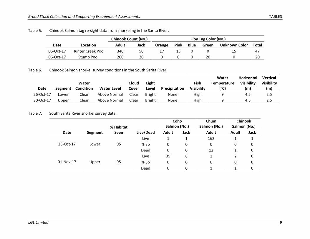
Survey conditions were optimal during the Chinook Salmon mark and re-sight survey. Water discharge was low with high visibility to enumerate salmon to species level (Table 4). Approximately 12% of the Chinook Salmon had tags in Hunter Creek pool, while 9% of the Chinook Salmon had tags in stump pool. The proportion (i.e., number) of tags by color are shown in Table 5. Despite optimal survey conditions it was difficult to identify the color of 15 tags due to the swarming behaviour of salmon in the pools. A Chinook Salmon population estimate could not be derived from the mark and re-sight data due to violations of the following model assumptions 1) incomplete stock mixing between mark and re-sight locations; and 2) stock emigration between the mark and re-sight locations. As such, the 2017 Chinook
Brood Stock Collection and Supporting Escapement Assessments RESULTS AND DISCUSSION
LGL Limited 5
Salmon escapement estimate should be calculated based upon the DFO area-under-the-curve (AUC) escapement methods using weekly snorkel survey data.
Weekly salmon escapement snorkel surveys commenced on September 21 and were led by the HFN fisheries staff. The survey data was compiled and submitted to DFO for AUC escapement estimate calculation.
Chinook Salmon carcass surveys were conducted on October 26 and 31 after the peak spawning period. High discharge immediately after peak spawning prevented safe and effective carcass surveys until the first carcass survey date. No tagged Chinook Salmon carcasses were sampled to determine residence timing; however, residence timing was at least 24 days based upon tags observed during the mark and re-sight survey. The survey data was provided to DFO for management purposes.
Survey conditions were optimal during the South Sarita River Chinook Salmon distribution surveys. Water discharge was above average but with high visibility to enumerate salmon to species level (Table 6). Chinook Salmon were observed in the lower segment on October 26 (Table 7). On November 1, Chinook Salmon carcasses were also observed in the upper segment in reach 22 upstream of the confined canyon (Table 7; Figure 4).
A total of eight juvenile steelhead ranging in length from 80-140 mm were caught upstream of the large log jam in Sabrina Creek (Table 8; Figure 5). Since juvenile steelhead do not have the ability to migrate upstream through fast riffles, cascades, or falls, this range in fork lengths is likely an indication of two age classes of steelhead that spawned in 2015 and in 2016 after the log jam formed in 2013 and 2014. Juvenile salmonid fry (< 30 mm fork length) were also visibly observed swimming at the time of survey, and if these fish were steelhead fry then three age classes were present upstream of the log jam. Therefore, the juveniles located upstream of the log jam are likely offspring of adult steelhead spawners that migrated past the logjam from 2014 to 2016, and therefore the log jam does not have to be removed.
3.2 Pachena and Sugsaw Watersheds Chum Salmon brood stock egg collection was conducted in Sugsaw Creek for the HFN hatchery. Coho Salmon brood stock egg collection was conducted in the Pachena River for the HFN hatchery. Both brood stock egg collections were led by HFN Fisheries staff and fish were spawned in the field then fertilized in the HFN Sugsaw Hatchery.

Brood Stock Collection and Supporting Escapement Assessments REFERENCES
LGL Limited 6
REFERENCES Barry. K. 2010. Habitat status report for the Sarita River watershed, Vancouver Island, BC. Prepared for
Department of Fisheries and Oceans Canada, Nanaimo, BC.
Burns, C. W., C. McCulloch, and J. Novoa. 2018. Sarita and Pachena watershed renewal: Sarita River Chinook and Chum salmon redd superimposition assessment. LGL Report EA3618B. Prepared for Huu ay aht First Nations, Anacla, BC.
Crawford, B., T. R. Mosey, and D. H. Johnson. 2007. Carcass counts. Pages 59-86 in: Johnson, D. H., B. M. Shrier, J. S. O’Neal, J. A. Knutzen, X. Augerot, T. A. O’Neil, and T. N. Pearsons. 2007. Salmonid field protocols handbook: Techniques for assessing status and trends in salmon and trout populations. American Fisheries Society, Bethesda, MD, in association with State of Salmon, Portland, OR.
DFO (Fisheries and Oceans Canada). 2015. WCVI snorkel survey protocols for salmon enumeration in west coast Vancouver Island streams. Nanaimo, BC.
LGL (LGL Limited). 2017. Sarita and Pachena watershed renewal framework. Prepared for Huu-ay-aht First Nation, Anacla, BC.
Brood Stock Collection and Supporting Escapement Assessments TABLES
LGL Limited 7
TABLES

blank page

Brood Stock Collection and Supporting Escapement Assessments TABLES
LGL Limited 8
Table 1. South Sarita River survey segment locations.
Segment Start Location End Location
Zone Northing Easting Zone Northing Easting Lower 10 5417935 357485 10 5417770 356443 Upper 10 5414441 357300 10 5415159 357363
Table 2. Chinook Salmon tagging data for the Sarita River.
Tagging Date
Tag Color Tag Location
No. Tagged Male - Adult Female - Adult Male - Jack Male - Jimmy Total
13-Sep-17 Orange Hunter Creek Pool 102 66 17 3 188 19-Sep-17 Pink Mine Pool 46 4 29 3 82 27-Sep-17 Blue Hunter Creek Pool 35 26 0 0 61 05-Oct-17 Green Mine Pool 41 37 11 0 89
Table 3. Chinook Salmon tag recaptures from seining in the Sarita River.
Sampling Date
Recapture Tag Color
Recapture Location
No. Tagged Recaptures Male - Adult Female - Adult Male - Jack Male - Jimmy Total
27-Sep-17 Orange Hunter Creek Pool 32 39 4 0 75 27-Sep-17 Pink Hunter Creek Pool 5 2 0 0 7
Table 4. Chinook Salmon mark and re-sight survey conditions in the Sarita River.
Date Time Water
Condition Water Level
Cloud Cover
Light Level Precipitation
Fish Visibility
Water Temperature
(°C)
Water Discharge
(m3/s)
Water Level (m)
06-Oct-17 9:30 Clear Below
Normal Overcast Dark Medium High 11 0.739 1.367
Brood Stock Collection and Supporting Escapement Assessments TABLES
LGL Limited 9
Table 5. Chinook Salmon tag re-sight data from snorkeling in the Sarita River.
Date Location Chinook Count (No.) Floy Tag Color (No.)
Adult Jack Orange Pink Blue Green Unknown Color Total 06-Oct-17 Hunter Creek Pool 340 50 17 15 0 0 15 47 06-Oct-17 Stump Pool 200 20 0 0 0 20 0 20
Table 6. Chinook Salmon snorkel survey conditions in the South Sarita River.
Date Segment Water
Condition Water Level Cloud Cover
Light Level Precipitation
Fish Visibility
Water Temperature
(°C)
Horizontal Visibility
(m)
Vertical Visibility
(m) 26-Oct-17 Lower Clear Above Normal Clear Bright None High 9 4.5 2.5 30-Oct-17 Upper Clear Above Normal Clear Bright None High 9 4.5 2.5
Table 7. South Sarita River snorkel survey data.
Date Segment % Habitat
Seen Live/Dead
Coho Salmon (No.)
Chum Salmon (No.)
Chinook Salmon (No.)
Adult Jack Adult Adult Jack
26-Oct-17 Lower 95 Live 1 1 162 1 1 % Sp 0 0 0 0 0 Dead 0 0 12 1 0
01-Nov-17 Upper 95 Live 35 8 1 2 0 % Sp 0 0 0 0 0 Dead 0 0 1 1 0

Brood Stock Collection and Supporting Escapement Assessments TABLES
LGL Limited 10
Table 8. Sabrina Creek minnow trapping data.
Trap No. Date In:Time In Date Out:Time Out Location (UTM Zone 10)
Species Fork Length (mm) Habitat Easting Northing 1 01-Aug-17:1431 02-Aug-17:1026 355880 5412054 No fish NA 0.3 m depth by log
2 01-Aug-17:1435 02-Aug-17:1030 355866 5412047 Steelhead
Steelhead
120
140
1 m depth in pool
3 01-Aug-17:1438 02-Aug-17:1045 355855 5412037 Steelhead
Steelhead
Steelhead
95
80
120
1 m depth by log jam
4 01-Aug-17:1447 02-Aug-17:1055 355791 5412004 Steelhead
Steelhead
100
100
0.5 m depth in pool
5 01-Aug-17:1452 02-Aug-17:1105 355740 5411990 Steelhead 100 0.7 m depth under log
6 01-Aug-17:1505 02-Aug-17:1115 355730 5411922 No fish NA 0.7 m depth under log
7 01-Aug-17:1515 02-Aug-17:0959 355895 5412123 No fish NA 0.5 m depth in riffle
8 01-Aug-17:1536 02-Aug-17:1215 354541 5410817 No fish NA 1.3 m depth in pool
9 01-Aug-17:1538 02-Aug-17:1225 354559 5410841 No fish NA 0.3 m depth under bridge
10 01-Aug-17:1540 02-Aug-17:1230 354559 5410841 No fish NA 0.3 m depth under bridge

blank page

Brood Stock Collection and Supporting Escapement Assessments FIGURES
LGL Limited 11
FIGURES

blank page

Brood Stock Collection and Supporting Escapement Assessments FIGURES
LGL Limited 12
Figure 1. Location of the Sarita, Pachena, and Sugsaw watersheds.

Brood Stock Collection and Supporting Escapement Assessments FIGURES
LGL Limited 13
Figure 2. Waterbodies of the Sarita, Pachena, and Sugsaw watersheds.

Brood Stock Collection and Supporting Escapement Assessments FIGURES
LGL Limited 14
Figure 3. Survey segments and pools within the Sarita River.

Brood Stock Collection and Supporting Escapement Assessments FIGURES
LGL Limited 15
Figure 4. Survey segments within the South Sarita River.

Brood Stock Collection and Supporting Escapement Assessments FIGURES
LGL Limited 16
Figure 5. Minnow trap locations within Sabrina Creek.


