drilling platform (Kuivinen, Antarctic Journal, this issue). Equip- ment for ice core processing and analyses was installed in the science trench. Stauffer and Schwander (Antarctic Journal, this issue) describe the core processing procedure and Kuivinen (Antarctic Journal, this issue) describes the ice core drilling operation. The processed ice consisted of 103 meters drilled from the surface in 1980-1981 and 120.7 meters drilled from 106 to 226.7 meters in 1982-1983. Each core section was cut longitudinally into two halves. One-half was split into two quarter sections which were packaged, identically marked, and returned to osu and uw for microparticle and oxygen isotope analyses, respec- tively. This procedure will allow more precise comparison of the microparticle and oxygen isotopic measurements and will facili- tate subsequent interpretation of the ice core record. Addi- tionally, electrical conductivity measurements which reflect acidity levels were conducted in the science trench. Stauffer and Schwander (Antarctic Journal, this issue) report that, although the signal of seasonal variations is small, the signals from large volcanic eruptions are clearly visible. Comparison of the con- ductivity profile with the microparticle concentration profile will provide a better indication of the contribution of volcanic activity to the enhanced particulate levels recorded at the South Pole between 1450 and 1850 A.D. We appreciate the National Science Foundation Division of Polar Programs' sponsorship of this work by grant DPP 80-18860. We are grateful for the opportunity to collaborate with our colleagues from the University of Washington, the University of Bern, and the Polar Ice Coring Office. References Hammer, C. U., H. B. Clausen, and W. Dansgaard. 1981. Past vol- canism and climate revealed b y Greenland ice cores. Journal of Vol- canology and Geothermal Research, 11(1), 3-10. Kuivinen, K. 1983. A 237-meter ice core from South Pole Station. Ant- arctic Journal of the U.S., 18(5). Lorius, C., L. Merlivat, J. Jouzel, and M. Pourchet. 1979. A 30,000-yr isotope climatic record from Antarctic ice. Nature, 280(5724), 644-648. Mosley-Thompson, E., and L. G. Thompson. 1982a. Microparticle analysis of the Ross Ice Shelf Q-13 core and preliminary analysis of the J-9 core. Annals of Glaciology, 3, 211-215. Mosley-Thompson, E., and L. G. Thompson. 1982b. Nine centuries of microparticle deposition at the South Pole. Quaternary Research, 17(1), 1-13. Neftel, A., H. Oeschger, J . Schwander, B. Stauffer, and R. Zumbrunn. 1982. Ice core sample measurements give atmospheric CO 2 content during the past 40,000 yr. Nature, 295(5846), 220-223. Stauffer, B., and J. Schwander. 1983. Core processing and analyses of ice cores drilled at the South Pole. Antarctic Journal of the U.S., 18(5). Thompson, L. G., and E. Mosley-Thompson. 1982. Microparticle con- centration variations linked with climatic change: Evidence from pol- ar ice cores. Science, 212(4496), 812-815. Satellite glaciology project RICHARD S. WILLIAMS, JR., JANE C. FERRIGNO, and TONY K MEUNIER U.S. Geological Survey Reston, Virginia 22092 During 1982-1983, the U.S. Geological Survey's satellite glaciology project involved a number of diverse research efforts, in which satellite remote sensing technology was used to gain a better understanding of the antarctic ice sheet and related phenomena. This article contains descriptions of five research projects and a discussion of other antarctic-related activities by the staff of the Satellite Glaciology Project. Satellite Image Atlas of Glaciers. In 1978, a major project was initiated by the U.S. Geological Survey to use Landsat images to define more accurately the global extent of glaciers (Ferrigno and Williams 1980; Williams and Ferrigno 1981). Approximately 50 U.S. and foreign scientists, representing 30 different organi- zations, have been involved in the preparation of a U.S. Geo- logical Survey Professional Paper, "Satellite Image Atlas of Glaciers." Chapter 2, "Antarctica," by Charles W. M. Swithin- bank, Head, Earth Sciences Division, British Antarctic Survey, was completed during 1982 and is currently undergoing tech- nical review before final preparation by the atlas editors, Richard S. Williams, Jr., and Jane G. Ferrigno. Index to and Table of Optimum Landsat Images of Antarctica. Scheduled for completion during the summer of 1983, this 1:5,000,000-scale index map (one side) and table (opposite side) will provide a quick and accurate reference to optimum Landsat multispectral scanner (MSS) and return beam vidicon (RBv) im- ages for each of the 2,470 Landsat nominal scene centers, which encompass Antarctica from the coast to 81°S latitude (maximum poleward coverage of Landsat) (Williams et al. 1982a). The index map and table will be released initially in the "U.S. Geological Survey Open-File Report" series and then published in the "I- Map" series and as Plate 1 of the "Satellite Image Atlas of Glaciers." Scientists from the Scott Polar Research Institute, Cambridge, England; Institut für Angewandte Geodàsie, Frankfurt-am-Main, Federal Republic of Germany; and the Branch of Astrogeologic Studies, Flagstaff, Arizona, have all made considerable use already of the manuscript copy of the index map and table during visits to the U.S. Geological Survey. Blue-ice, Meteorites, and Satellite Imagery in Antarctica. Richard S. Williams, Jr., was invited to a National Aeronautics and Space Administration/National Science Foundation sponsored "Work- shop on Antarctic Glaciology and Meteorites" in April 1982 and presented a paper on "Delineation of Blue-Ice Areas in Ant- arctica from Satellite Imagery" (Williams, Meunier, and Ferrig- no 1982b, 1983). Recommendations for improved recovery of meteorites from Antarctica (figure 1) were also made at the workshop (Williams 1982). Tony K. Meunier participated in a 2-month field expedition to the Allan Hills area and environs, Antarctica, as a team member during the 1982-1983 meteorite search led by William A. Cas- sidy, University of Pittsburgh. In addition to operating a Mag- 1983 REVIEW 119
Transcript
drilling platform (Kuivinen, Antarctic Journal, this issue). Equip-ment for ice core processing and analyses was installed in thescience trench. Stauffer and Schwander (Antarctic Journal, thisissue) describe the core processing procedure and Kuivinen(Antarctic Journal, this issue) describes the ice core drillingoperation.
The processed ice consisted of 103 meters drilled from thesurface in 1980-1981 and 120.7 meters drilled from 106 to 226.7meters in 1982-1983. Each core section was cut longitudinallyinto two halves. One-half was split into two quarter sectionswhich were packaged, identically marked, and returned to osuand uw for microparticle and oxygen isotope analyses, respec-tively. This procedure will allow more precise comparison of themicroparticle and oxygen isotopic measurements and will facili-tate subsequent interpretation of the ice core record. Addi-tionally, electrical conductivity measurements which reflectacidity levels were conducted in the science trench. Stauffer andSchwander (Antarctic Journal, this issue) report that, althoughthe signal of seasonal variations is small, the signals from largevolcanic eruptions are clearly visible. Comparison of the con-ductivity profile with the microparticle concentration profilewill provide a better indication of the contribution of volcanicactivity to the enhanced particulate levels recorded at the SouthPole between 1450 and 1850 A.D.
We appreciate the National Science Foundation Division ofPolar Programs' sponsorship of this work by grant DPP
80-18860. We are grateful for the opportunity to collaboratewith our colleagues from the University of Washington, theUniversity of Bern, and the Polar Ice Coring Office.
References
Hammer, C. U., H. B. Clausen, and W. Dansgaard. 1981. Past vol-canism and climate revealed b y Greenland ice cores. Journal of Vol-canology and Geothermal Research, 11(1), 3-10.
Kuivinen, K. 1983. A 237-meter ice core from South Pole Station. Ant-arctic Journal of the U.S., 18(5).
Lorius, C., L. Merlivat, J. Jouzel, and M. Pourchet. 1979. A 30,000-yrisotope climatic record from Antarctic ice. Nature, 280(5724), 644-648.
Mosley-Thompson, E., and L. G. Thompson. 1982a. Microparticleanalysis of the Ross Ice Shelf Q-13 core and preliminary analysis ofthe J-9 core. Annals of Glaciology, 3, 211-215.
Mosley-Thompson, E., and L. G. Thompson. 1982b. Nine centuries ofmicroparticle deposition at the South Pole. Quaternary Research, 17(1),1-13.
Neftel, A., H. Oeschger, J. Schwander, B. Stauffer, and R. Zumbrunn.1982. Ice core sample measurements give atmospheric CO 2 contentduring the past 40,000 yr. Nature, 295(5846), 220-223.
Stauffer, B., and J. Schwander. 1983. Core processing and analyses of icecores drilled at the South Pole. Antarctic Journal of the U.S., 18(5).
Thompson, L. G., and E. Mosley-Thompson. 1982. Microparticle con-centration variations linked with climatic change: Evidence from pol-ar ice cores. Science, 212(4496), 812-815.
Satellite glaciology project
RICHARD S. WILLIAMS, JR., JANE C. FERRIGNO, and TONY KMEUNIER
U.S. Geological SurveyReston, Virginia 22092
During 1982-1983, the U.S. Geological Survey's satelliteglaciology project involved a number of diverse researchefforts, in which satellite remote sensing technology was usedto gain a better understanding of the antarctic ice sheet andrelated phenomena. This article contains descriptions of fiveresearch projects and a discussion of other antarctic-relatedactivities by the staff of the Satellite Glaciology Project.
Satellite Image Atlas of Glaciers. In 1978, a major project wasinitiated by the U.S. Geological Survey to use Landsat images todefine more accurately the global extent of glaciers (Ferrignoand Williams 1980; Williams and Ferrigno 1981). Approximately50 U.S. and foreign scientists, representing 30 different organi-zations, have been involved in the preparation of a U.S. Geo-logical Survey Professional Paper, "Satellite Image Atlas ofGlaciers." Chapter 2, "Antarctica," by Charles W. M. Swithin-bank, Head, Earth Sciences Division, British Antarctic Survey,was completed during 1982 and is currently undergoing tech-nical review before final preparation by the atlas editors,Richard S. Williams, Jr., and Jane G. Ferrigno.
Index to and Table of Optimum Landsat Images of Antarctica.Scheduled for completion during the summer of 1983, this1:5,000,000-scale index map (one side) and table (opposite side)will provide a quick and accurate reference to optimum Landsatmultispectral scanner (MSS) and return beam vidicon (RBv) im-ages for each of the 2,470 Landsat nominal scene centers, whichencompass Antarctica from the coast to 81°S latitude (maximumpoleward coverage of Landsat) (Williams et al. 1982a). The indexmap and table will be released initially in the "U.S. GeologicalSurvey Open-File Report" series and then published in the "I-Map" series and as Plate 1 of the "Satellite Image Atlas ofGlaciers." Scientists from the Scott Polar Research Institute,Cambridge, England; Institut für Angewandte Geodàsie,Frankfurt-am-Main, Federal Republic of Germany; and theBranch of Astrogeologic Studies, Flagstaff, Arizona, have allmade considerable use already of the manuscript copy of theindex map and table during visits to the U.S. Geological Survey.
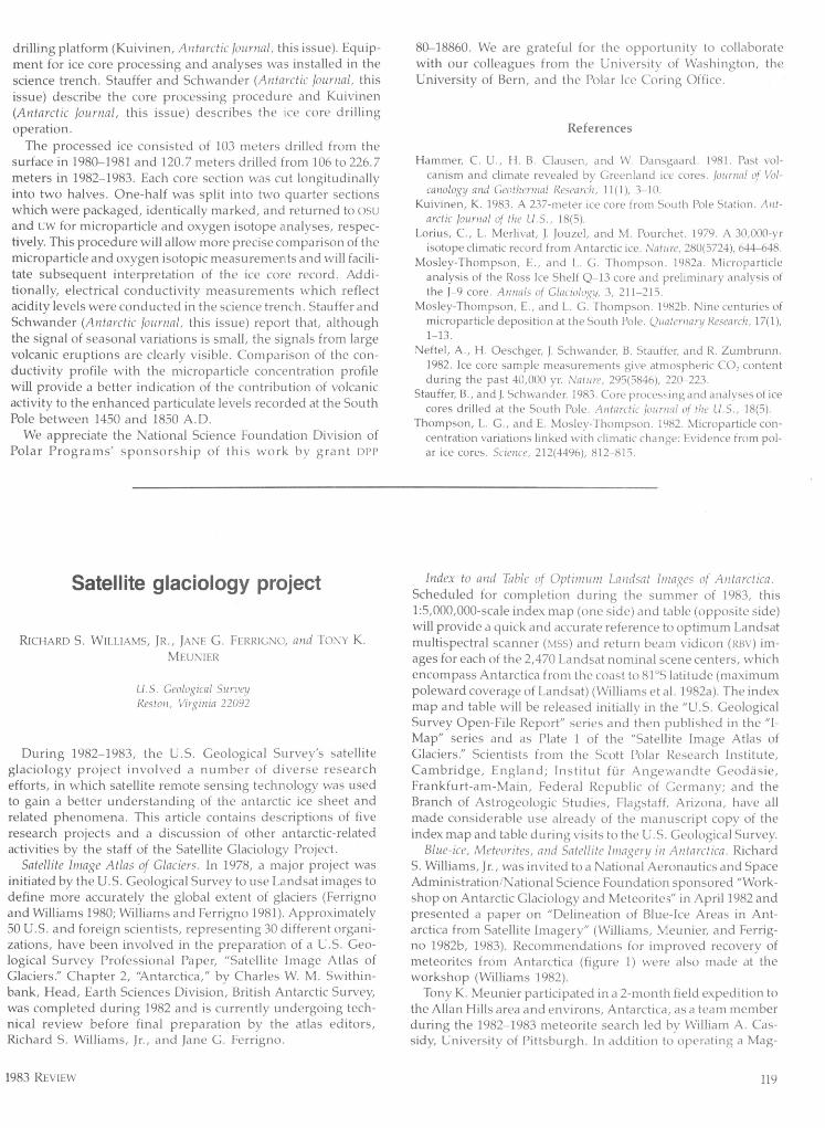
Blue-ice, Meteorites, and Satellite Imagery in Antarctica. RichardS. Williams, Jr., was invited to a National Aeronautics and SpaceAdministration/National Science Foundation sponsored "Work-shop on Antarctic Glaciology and Meteorites" in April 1982 andpresented a paper on "Delineation of Blue-Ice Areas in Ant-arctica from Satellite Imagery" (Williams, Meunier, and Ferrig-no 1982b, 1983). Recommendations for improved recovery ofmeteorites from Antarctica (figure 1) were also made at theworkshop (Williams 1982).
Tony K. Meunier participated in a 2-month field expedition tothe Allan Hills area and environs, Antarctica, as a team memberduring the 1982-1983 meteorite search led by William A. Cas-sidy, University of Pittsburgh. In addition to operating a Mag-
1983 REVIEW 119
AMERY ICE SHELF
Figure 1. Landsat 1 multlspectral scanner (Mss) band 7 (0.8 to 1.1micrometer) image of the Queen Fabiola (Yamato) Mountains Area,East Antarctica, showing extensive areas of blue ice aroundnunataks (bedrock areas). Landsat image number 1538-05175 (path157, row 111) was acquired on 2 January 1974. This and otherLandsat images of Antarctica are archived by the National Oceanicand Atmospheric Administration (NOAA) at the Earth ResourcesObservation Systems (EROS) Data Center, Sioux Falls, South Dako-ta 57198.
navox Model 1502 satellite positioning system to identify thecorrect geodetic location of meteorite finds, he used a Landsatimage to locate and navigate to blue-ice areas. The Magnavoxinstrument was generously loaned to the project by JohnBrewer of the Bureau of Land Management. All blue-ice areasvisited by the 1982-1983 team contained meteorites (113 total,50 from the Thiel Mountains/Pecora Escarpment region and 63
from several locations in the drainage basin of the David Glacier,Victoria Land). Based on field observations and evaluation ofLandsat images of Antarctica to about 81°S latitude and NOAA-6
and -7 advanced very high resolution radiometer (AVHRR) im-ages of the area poleward of 81°S latitude, a 1:5,000,000-scalethematic map delineating blue-ice areas in Antarctica could bereadily prepared (Williams 1982).
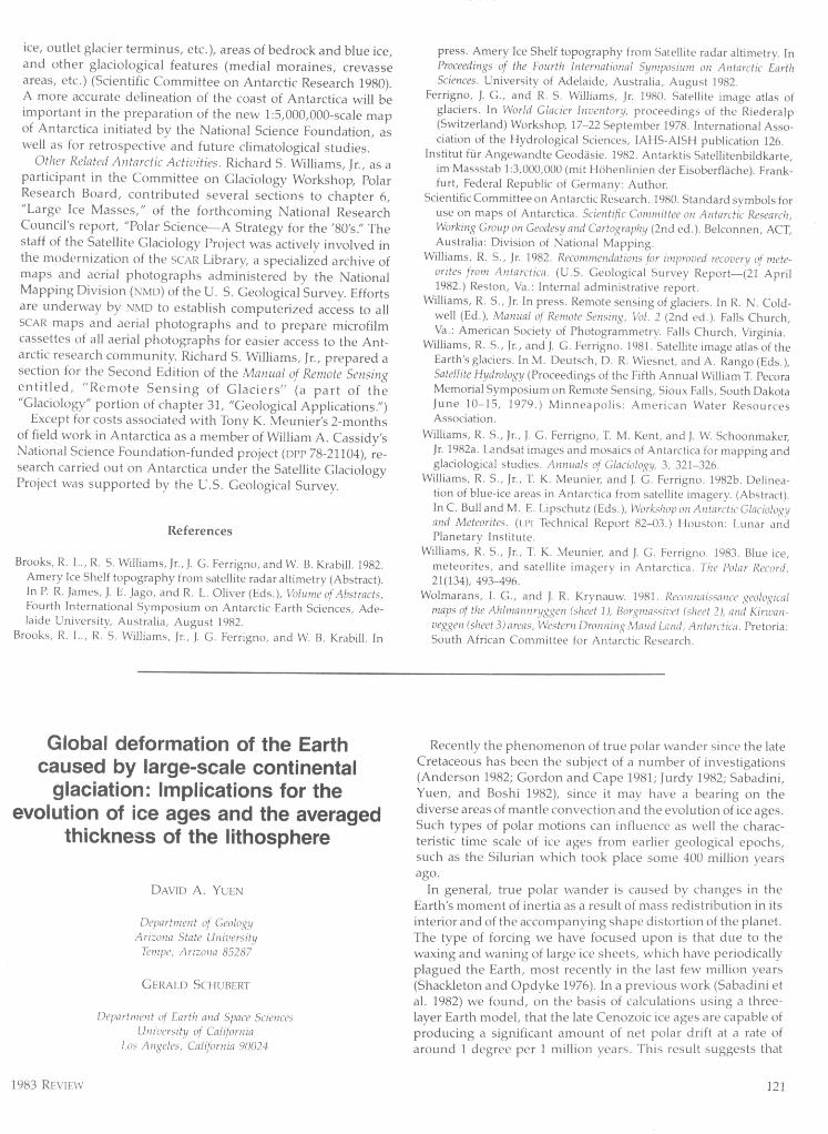
Satellite Radar Altimetry of the Amery Ice Shelf, East Antarctica.An innovative experiment was completed using a Landsat im-age mosaic of Antarctica as the map base for compilation of datafrom another satellite sensor. One- and five-meter elevationcontours derived by Ronald L. Brooks (GeoScience ResearchCorporation) from Seasat radar altimetry data were compiled ona 1:500,000-scale Landsat image mosaic of the Amery Ice Shelfand environs, East Antarctica (figure 2) (Brooks et al. 1982, inpress). The Amery Ice Shelf experiment reemphasized the fact
that satellite image maps can be effectively used as multi-pur-pose base maps (Institut für Angewandte Geodäsie 1982), forthe compilation of various types of geological (Wolmarans andKrynauw 1981), glaciological (Brooks et al. in press), andgeophysical data.
Coastal Maps of Antarctica. In association with Charles W. M.Swithinbank of the British Antarctic Survey, preliminary workhas begun on the preparation of a set of 24 1:1,000,000-scaleplanimetric maps of coastal areas, bedrock exposures(nunataks), and blue-ice areas of Antarctica based on analysis of1:500,000-scale Landsat images. Scientific Committee on Ant-arctic Research (SCAR) standard symbols (or modification ofSCAR symbols where appropriate) will be used to depict thenature of the continent's edge (bedrock, floating ice, grounded
Figure 2. Contours plotted on an uncontrolled Landsat multi-spectral scanner (Mss) image mosaic of the Amery Ice Shelf and theterminus of the Lambert Glacier, East Antarctica. The 1- and 5-metercontours were determined from numerous Seasat radar altimetertraverses across the area. Contours courtesy of GeoScience Re-search Corporation (Brooks et al. 1982, in press). Landsat imagescan be used as planimetric base maps, where adequate geodeticcontrol is present for the plotting of geological (Wolmarans andKrynauw 1981) and geophysical data. (From figure in chapter 31,"Geological Applications," Manual of Remote Sensing, second edi-tion. Courtesy of American Society of Photogrammetry, FallsChurch, Virginia.)
<4
120 ANTARCTIC JOURNAL
ice, outlet glacier terminus, etc.), areas of bedrock and blue ice,and other glaciological features (medial moraines, crevasseareas, etc.) (Scientific Committee on Antarctic Research 1980).A more accurate delineation of the coast of Antarctica will beimportant in the preparation of the new 1:5,000,000-scale mapof Antarctica initiated by the National Science Foundation, aswell as for retrospective and future climatological studies.
Other Related Antarctic Activities. Richard S. Williams, Jr., as aparticipant in the Committee on Glaciology Workshop, PolarResearch Board, contributed several sections to chapter 6,"Large Ice Masses," of the forthcoming National ResearchCouncil's report, "Polar Science—A Strategy for the '80's." Thestaff of the Satellite Glaciology Project was actively involved inthe modernization of the SCAR Library, a specialized archive ofmaps and aerial photographs administered by the NationalMapping Division (NMD) of the U. S. Geological Survey. Effortsare underway by NMD to establish computerized access to allSCAR maps and aerial photographs and to prepare microfilmcassettes of all aerial photographs for easier access to the Ant-arctic research community. Richard S. Williams, Jr., prepared asection for the Second Edition of the Manual of Remote Sensingentitled, "Remote Sensing of Glaciers" (a part of the"Glaciology" portion of chapter 31, "Geological Applications.")
Except for costs associated with Tony K. Meunier's 2-monthsof field work in Antarctica as a member of William A. Cassidy'sNational Science Foundation-funded project (DPP 78-21104), re-search carried out on Antarctica under the Satellite GlaciologyProject was supported by the U.S. Geological Survey.
References
Brooks, R. L., R. S. Williams, Jr., J. C. Ferrigno, and W. B. Krabill. 1982.Amery Ice Shelf topography from satellite radar altimetry (Abstract).In P. R. James, J. E. Jago, and R. L. Oliver (Eds.), Volume of Abstracts,Fourth International Symposium on Antarctic Earth Sciences, Ade-laide University, Australia, August 1982.
Brooks, R. L., R. S. Williams, Jr., J . C. Ferrigno, and W. B. Krabill. In
press. Amery Ice Shelf topography from Satellite radar altimetry. InProceedings of the Fourth International Symposium on Antarctic EarthSciences. University of Adelaide, Australia, August 1982.
Ferrigno, J. C., and R. S. Williams, Jr. 1980. Satellite image atlas ofglaciers. In World Glacier Inventory, proceedings of the Riederalp(Switzerland) Workshop, 17-22 September 1978. International Asso-ciation of the Hydrological Sciences, IAHS-AISH publication 126.
Institut für Angewandte Ceodäsie. 1982. Antarktis Satellitenbildkarte,im Massstab 1:3,000,000 (mit HOhenlinien der Eisoberfläche). Frank-furt, Federal Republic of Germany: Author.
Scientific Committee on Antarctic Research. 1980. Standard symbols foruse on maps of Antarctica. Scientific Committee on Antarctic Research,Working Group on Geodesy and Cartography (2nd ed.). Belconnen, ACT,Australia: Division of National Mapping.
Williams, R. S., Jr. 1982. Recommendations for improved recovery of mete-orites from Antarctica. (U.S. Geological Survey Report—(21 April1982.) Reston, Va.: Internal administrative report.
Williams, R. S., Jr. In press. Remote sensing of glaciers. In R. N. Cold-well (Ed.), Manual of Remote Sensing, Vol. 2 (2nd ed.). Falls Church,Va.: American Society of Photogrammetry. Falls Church, Virginia.
Williams, R. S., Jr., and J. G. Ferrigno. 1981. Satellite image atlas of theEarth's glaciers. In M. Deutsch, D. R. Wiesnet, and A. Rango (Eds.),Satellite Hydrology (Proceedings of the Fifth Annual William I. PecoraMemorial Symposium on Remote Sensing, Sioux Falls, South DakotaJune 10-15, 1979.) Minneapolis: American Water ResourcesAssociation.
Williams, R. S., Jr., J . G. Ferrigno, I. M. Kent, and J. W. Schoonmaker,Jr. 1982a. Landsat images and mosaics of Antarctica for mapping andglaciological studies. Annuals of Glaciology, 3, 321-326.
Williams, R. S., Jr., T. K. Meunier, and J . C. Ferrigno. 1982b. Delinea-tion of blue-ice areas in Antarctica from satellite imagery. (Abstract).In C. Bull and M. E. Lipschutz (Eds.), Workshop on Antarctic Glaciologyand Meteorites. (Li'! Technical Report 82-03.) Houston: Lunar andPlanetary Institute.
Williams, R. S., Jr., 1. K. Meunier, and J . G. Ferrigno. 1983. Blue ice,meteorites, and satellite imagery in Antarctica. The Polar Record,21(134), 493-496.
Wolmarans, I. G., and J. R. Krynauw. 1981. Reconnaissance geologicalmaps of the Ahlmannryggen (sheet 1), Borymassivet (sheet 2), and Kirwan-veggen (sheet 3) areas, Western Dronning Maud Lcnd, Antarctica. Pretoria:South African Committee for Antarctic Research.
Global deformation of the Earthcaused by large-scale continental
glaciation: Implications for theevolution of ice ages and the averaged
thickness of the lithosphere
DAVID A. YUEN
Department of GeologyArizona State University
Tempe, Arizona 85287
GERALD SCHUBERT
Department of Earth and Space SciencesUniversity of California
Los Angeles, California 90024
Recently the phenomenon of true polar wander since the lateCretaceous has been the subject of a number of investigations(Anderson 1982; Gordon and Cape 1981; Jurdy 1982; Sabadini,Yuen, and Boshi 1982), since it may have a bearing on thediverse areas of mantle convection and the evolution of ice ages.Such types of polar motions can influence as well the charac-teristic time scale of ice ages from earlier geological epochs,such as the Silurian which took place some 400 million yearsago.
In general, true polar wander is caused by changes in theEarth's moment of inertia as a result of mass redistribution in itsinterior and of the accompanying shape distortion of the planet.The type of forcing we have focused upon is that due to thewaxing and waning of large ice sheets, which have periodicallyplagued the Earth, most recently in the last few million years(Shackleton and Opdyke 1976). In a previous work (Sabadini etal. 1982) we found, on the basis of calculations using a three-layer Earth model, that the late Cenozoic ice ages are capable ofproducing a significant amount of net polar drift at a rate ofaround 1 degree per 1 million years. This result suggests that