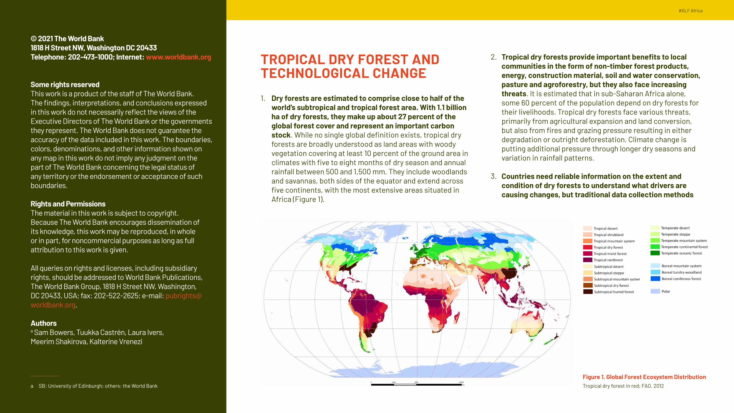
1. Dry forests are estimated to comprise close to half of the world’s subtropical and tropical forest area. With 1.1 billion ha of dry forests, they make up about 27 percent of the global forest cover and represent an important carbon stock. While no single global definition exists, tropical dry forests are broadly understood as land areas with woody vegetation covering at least 10 percent of the ground area in climates with five to eight months of dry season and annual rainfall between 500 and 1,500 mm. They include woodlands and savannas, both sides of the equator and extend across five continents, with the most extensive areas situated in Africa (Figure 1).
Some rights reservedThis work is a product of the staff of The World Bank. The findings, interpretations, and conclusions expressed in this work do not necessarily reflect the views of the Executive Directors of The World Bank or the governments they represent. The World Bank does not guarantee the accuracy of the data included in this work. The boundaries, colors, denominations, and other information shown on any map in this work do not imply any judgment on the part of The World Bank concerning the legal status of any territory or the endorsement or acceptance of such boundaries.
Rights and PermissionsThe material in this work is subject to copyright. Because The World Bank encourages dissemination of its knowledge, this work may be reproduced, in whole or in part, for noncommercial purposes as long as full attribution to this work is given.
All queries on rights and licenses, including subsidiary rights, should be addressed to World Bank Publications, The World Bank Group, 1818 H Street NW, Washington, DC 20433, USA; fax: 202-522-2625; e-mail: [email protected].
Authorsa Sam Bowers, Tuukka Castrén, Laura Ivers, Meerim Shakirova, Kalterine Vrenezi
a SB: University of Edinburgh; others: the World Bank
Figure 1. Global Forest Ecosystem Distribution Tropical dry forest in red; FAO. 2012
2. Tropical dry forests provide important benefits to local communities in the form of non-timber forest products, energy, construction material, soil and water conservation, pasture and agroforestry, but they also face increasing threats. It is estimated that in sub-Saharan Africa alone, some 60 percent of the population depend on dry forests for their livelihoods. Tropical dry forests face various threats, primarily from agricultural expansion and land conversion, but also from fires and grazing pressure resulting in either degradation or outright deforestation. Climate change is putting additional pressure through longer dry seasons and variation in rainfall patterns.
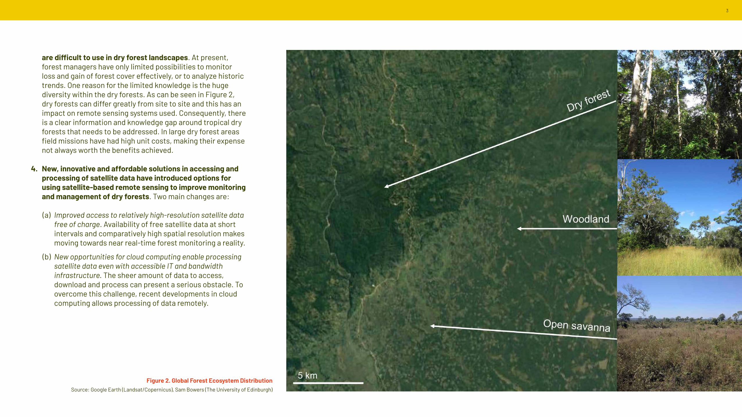
3. Countries need reliable information on the extent and condition of dry forests to understand what drivers are causing changes, but traditional data collection methods
Figure 2. Global Forest Ecosystem Distribution Source: Google Earth (Landsat/Copernicus), Sam Bowers (The University of Edinburgh)
are difficult to use in dry forest landscapes. At present, forest managers have only limited possibilities to monitor loss and gain of forest cover effectively, or to analyze historic trends. One reason for the limited knowledge is the huge diversity within the dry forests. As can be seen in Figure 2, dry forests can differ greatly from site to site and this has an impact on remote sensing systems used. Consequently, there is a clear information and knowledge gap around tropical dry forests that needs to be addressed. In large dry forest areas field missions have had high unit costs, making their expense not always worth the benefits achieved.
4. New, innovative and affordable solutions in accessing and processing of satellite data have introduced options for using satellite-based remote sensing to improve monitoring and management of dry forests. Two main changes are:
(a) Improved access to relatively high-resolution satellite data free of charge. Availability of free satellite data at short intervals and comparatively high spatial resolution makes moving towards near real-time forest monitoring a reality.
(b) New opportunities for cloud computing enable processing satellite data even with accessible IT and bandwidth infrastructure. The sheer amount of data to access, download and process can present a serious obstacle. To overcome this challenge, recent developments in cloud computing allows processing of data remotely.
4 #GLF Africa
EARTH OBSERVATION TECHNOLOGY - NEW OPPORTUNITIES FOR FOREST MEASURING AND MONITORING
5. Newly developed Earth Observation (EO) data processing tools allow forest managers and remote sensing specialists to access and exploit new data sources and improve the accuracy and timeliness of forest data. For instance, EO data allows monitoring of large areas without expensive field missions. Some tools can be used to provide early warning information that is not necessarily very detailed but is timely and helps in directing management activities (e.g. law enforcement or protection). Making use of frequently updated satellite data allows detection of early changes in forests at short intervals (i.e. near real-time), often related to degradation as a precursor to deforestation. The key benefits of using satellite data include the following:
(a) Information becomes available from large, previously poorly covered or even inaccessible areas.
(b) Once systems have been established and tools calibrated, the unit cost of repeat assessments (e.g. annual or more frequent monitoring) may below.
(c) Information is easy to validate, distribute and it becomes almost tamper-proof.
6. Satellite data systems do not solve all information challenges in forest monitoring: they require upfront investments, capacity building and localization. All these can be costly and time-consuming. Some of the issues to be addressed when using satellite-based remote sensing data include the following:
(a) Satellite monitoring is an indirect way of collecting information and not all variables can be monitored by satellites1;
1 For example, in dry forests it is difficult to differentiate very low levels of tree cover from grasses and other ground vegetation. This leads also to challenges in monitoring forest regrowth. Also tree species are not easily identified.
(a) Systems require technical and human capacity that is not always available and can be costly to build; and,
(b) Technical development is rapid and staying updated requires constant updating of systems.
7. In most cases, using satellite data alone without ground-truthing gives a relatively superficial view of the forest resource, and obtaining reliable information requires field observations. Satellite data is as good as it is designed to be, and it does not analyze or explain the characteristics forests have. It only records what it sees and therefore, it is essential that satellite data is combined with field observations made with human eye. Only then can the satellite data can reveal more, and end-users are able to interpret what the images tell. Training datasets2 or calibration data can be (i) produced from field surveys, (ii) taken from existing data sets (e.g. forest inventory plots) or (iii) identified using higher resolution remote sensing data.
8. Different types of information are used in different places and often there is a trade-off between having recent and updated information, and on having detailed and precise information. For example, payments for REDD+ or other environmental services, need to be based on accurate and detailed data on forest cover and biomass. However, this information does not need to be collected often – for example, annual data is adequate and it can be based on measurements done earlier. On the other hand, information needed for active forest management (including law enforcement) on the ground can more less precise but must be available frequently and must be based on freshly obtained data (i.e. near real-time). While remote sensing can provide invaluable information on where human intervention is needed, the actual interventions need to be conducted on the ground. Therefore, it is essential that earth observation systems and information are closely integrated with information systems for operational planning and management.
2 “Training datasets” are data that have known characteristics (e.g. forest type) and can be used to verify the link between field observations and satellite data.
5
TOOLS USING SATELLITE DATA: EXAMPLES FROM THE SATELLITE MONITORING FOR FOREST MANAGEMENT PROJECT
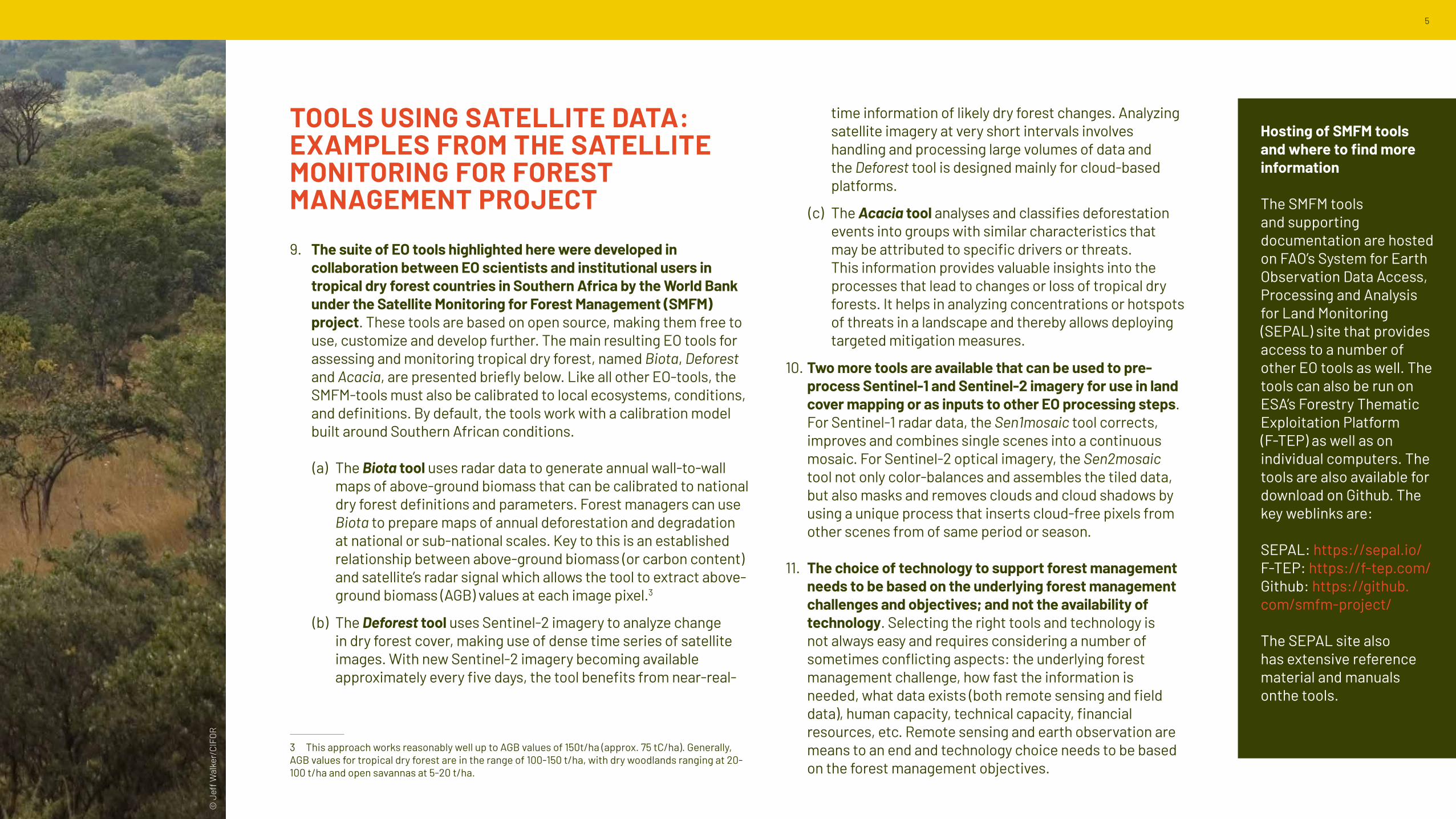
9. The suite of EO tools highlighted here were developed in collaboration between EO scientists and institutional users in tropical dry forest countries in Southern Africa by the World Bank under the Satellite Monitoring for Forest Management (SMFM) project. These tools are based on open source, making them free to use, customize and develop further. The main resulting EO tools for assessing and monitoring tropical dry forest, named Biota, Deforest and Acacia, are presented briefly below. Like all other EO-tools, the SMFM-tools must also be calibrated to local ecosystems, conditions, and definitions. By default, the tools work with a calibration model built around Southern African conditions.
(a) The Biota tool uses radar data to generate annual wall-to-wall maps of above-ground biomass that can be calibrated to national dry forest definitions and parameters. Forest managers can use Biota to prepare maps of annual deforestation and degradation at national or sub-national scales. Key to this is an established relationship between above-ground biomass (or carbon content) and satellite’s radar signal which allows the tool to extract above-ground biomass (AGB) values at each image pixel.3
(b) The Deforest tool uses Sentinel-2 imagery to analyze change in dry forest cover, making use of dense time series of satellite images. With new Sentinel-2 imagery becoming available approximately every five days, the tool benefits from near-real-
3 This approach works reasonably well up to AGB values of 150t/ha (approx. 75 tC/ha). Generally, AGB values for tropical dry forest are in the range of 100-150 t/ha, with dry woodlands ranging at 20-100 t/ha and open savannas at 5-20 t/ha.
time information of likely dry forest changes. Analyzing satellite imagery at very short intervals involves handling and processing large volumes of data and the Deforest tool is designed mainly for cloud-based platforms.
(c) The Acacia tool analyses and classifies deforestation events into groups with similar characteristics that may be attributed to specific drivers or threats. This information provides valuable insights into the processes that lead to changes or loss of tropical dry forests. It helps in analyzing concentrations or hotspots of threats in a landscape and thereby allows deploying targeted mitigation measures.
10. Two more tools are available that can be used to pre-process Sentinel-1 and Sentinel-2 imagery for use in land cover mapping or as inputs to other EO processing steps. For Sentinel-1 radar data, the Sen1mosaic tool corrects, improves and combines single scenes into a continuous mosaic. For Sentinel-2 optical imagery, the Sen2mosaic tool not only color-balances and assembles the tiled data, but also masks and removes clouds and cloud shadows by using a unique process that inserts cloud-free pixels from other scenes from of same period or season.
11. The choice of technology to support forest management needs to be based on the underlying forest management challenges and objectives; and not the availability of technology. Selecting the right tools and technology is not always easy and requires considering a number of sometimes conflicting aspects: the underlying forest management challenge, how fast the information is needed, what data exists (both remote sensing and field data), human capacity, technical capacity, financial resources, etc. Remote sensing and earth observation are means to an end and technology choice needs to be based on the forest management objectives.
Hosting of SMFM tools and where to find more information
The SMFM tools and supporting documentation are hosted on FAO’s System for Earth Observation Data Access, Processing and Analysis for Land Monitoring (SEPAL) site that provides access to a number of other EO tools as well. The tools can also be run on ESA’s Forestry Thematic Exploitation Platform (F-TEP) as well as on individual computers. The tools are also available for download on Github. The key weblinks are:
MAINSTREAMING EO TOOLS IN FORESTRY OPERATIONS: OPPORTUNITIES AND OPTIONS
12. High-quality forest management requires access to adequate and accurate information, and innovative, EO-based forest monitoring approaches open up new avenues for improved and information-based forest management. New technology can enable approaches to forest management that were not available a few years ago. Easily accessible and exploitable satellite data can help reveal early deforestation that previously remained undetected. Being able to tap into the vast and constantly increasing volume of available earth observation data, provides a new dimension to forest management, and in particular, to forest monitoring. A satellite-based early warning system for deforestation is just one example of a new technology that makes a previously impossible task an achievable reality.
13. Continuous biomass maps: a new way of looking at an old problem. Less dramatic, but still ground-breaking, is the possibility to generate nation-wide, wall-to-wall maps and digital datasets representing actual above-ground biomass levels, based on a systematic measurement using satellite radar data. Currently widely available conventional forest type maps simply show classes or categories of forest types. Changes only appear when there is a change from one forest type to another and change within a class is not detected or shown.4 By contrast, maps of continuous variables can also
4 Change in class does not necessarily reflect how big the change has been. For example, if canopy cover is barely above the threshold in the local forest definition and it declines just below it, the change is classified as deforestation. As a comparison, as long as the canopy cover percentage remains above the threshold in the forest definition, even large canopy cover changes are not identified in deforestation maps.
reveal low-level change, making them highly relevant for early detection of degradation and deforestation. This may also lead to new ways of reporting on actual changes in biomass instead of simply on forest/non-forest categories.
14. With many EO tools and data being free of charge, testing becomes easier and new approaches can be developed to meet localized information needs. Given that the monitoring tools are freely accessible and use open access EO data, there is little cost – other than staff time and other in-house costs – to testing the tools in the operational context. Forest managers should enable and encourage technical staff and monitoring specialists to explore the tools and their documentation and run the tools on small, well-known areas. This allows judgement of the tool’s relevance and the assessing added value that the tools could provide to existing forest monitoring processes. In addition, if these modern tools are used on EO platforms such as SEPAL, users can test and compare the tools to other methodologies offered on the platforms.
15. To benefit from the potential of modern EO approaches, relevant tools need to be integrated into existing forestry department operations and processes making these more efficient. This also requires that the importance of information management is recognized by senior management. The new EO methodologies have been developed into open source software tools that are well documented, their implementation is relatively feasible in professional organizations. This requires local capacity to adjust and use the applications, and forest departments interested in making use of the tools need to have staff capacity, and remote sensing and IT skills. Irrespective of the institutional format, it is essential that information is recognized as an essential part of forest administration. If possible, agencies can nominate a chief information officer at senior management level. This would demonstrate that information management and use of appropriate data is recognized at the highest level.
GLF Africa Digital Conference 2021 would not be possible without the support and participation of the following hosts, partners and organizations. For a full list of everyone involved, please visit: events.globallandscapesforum.org/africa-2021/partners
GLOBAL LANDSCAPES FORUM
The Global Landscapes Forum (GLF) is the world’s largest knowledge-led platform on integrated land use, dedicated to achieving the Sustainable Development Goals and Paris Climate Agreement. The Forum takes a holistic approach to create sustainable landscapes that are productive, prosperous, equitable and resilient and considers five cohesive themes of food and livelihood initiatives, landscape restoration, rights, finance and measuring progress. It is led by the Center for International Forestry Research (CIFOR), in collaboration with its co-founders UN Environment and the World Bank and Charter Members.
Charter Members: CIAT, CIFOR, CIRAD, Climate Focus, Conservation International, Crop Trust, Ecoagriculture Partners, EFI, Evergreen Agriculture, FSC, GEF, GIZ, ICIMOD, IFOAM - Organics International, ILRI, INBAR, IPMG, IUFRO, Rainforest Alliance, Rare, RRI, SAN, UN Environment, (TMG) Think Tank, Wageningen Centre for Development Innovation, part of Wageningen Research, WFO, World Agroforestry, World Bank Group, WRI, WWF Germany, Youth in Landscapes Initiative.
RESTORING AFRICA’S DRYLANDSACCELERATING ACTION ON THE GROUND