71
| Date post: | 17-Jul-2015 |
| Category: |
Education |
| Upload: | rahman-hakim |
| View: | 124 times |
| Download: | 0 times |


By THOMAS Y. CANBY i'IAT!OSAL GEOORAPIIIC SEI" IOR WRITER
HEY DWELL IN THE DARK HEAVENS in growing legions, silently circling like swarms of small moons. They are the ingenious spacefarers we call satellites, doing our bidding in ways that enrich the lives of virtually all of us.
Squinting through electronic eyes from hundreds of miles overhead, they lead prospectors to mineral deposits invisible on earth's surface. Relaying communications at the speed of light, they shrink the planet until its most distant peoples are only a split second apart. They beam sweeping vistas of world weather to our livingroom TV and guide ships through darkness and storm. Swooping low over areas of possible hostility, spies in the sky maintain a surveillance that helps keep peace in a volatile world.
How many objects, exactly, are orbiting out there? "Today's count is 4,914," responded Lt. Col. Terry O'Rourke as
we explored the fortified lair ofNORAD, the North American Aerospace Defense Command, hidden 1, 700 feet inside Cheyenne Mountain near Colorado Springs. "Enough stuff that we have to worry about things banging into one another.
"We track everything in orbit, though four-fifths of it's junk spewed into space with satellite launches-rocket bodies, nose cones, spent fuel containers. And by watching them as they fall from orbit, we can spot what shouldn't be there, such as enemy missiles."
I examined NORAD's catalog, a record of hardware shot into space since the Soviet Union's stunning launch of Sputnik 1 in 195 7. It tallied more than 14,000 man-made objects, two-thirds of which have since fallen back into earth's atmosphere and burned up, including that first Sputnik.
Oddly, no one is quite sure how many of these orbiting objects are active, performing missions for mankind. For the best estimate I turned to the National Aeronautics and Space Administration, the agency that guides the United States' satellite effort.
"We count about 290 operable spacecraft at the moment," said Robert Vostreys of NASA's National Space Science Data Center in Greenbelt, Maryland. "Some 180 belong to the United States, and another hundred or so are Soviet. Japan, Canada, Indonesia, India, China, Australia, and 13 European nations own the rest. But the
Handymen of the heavens, earth satellites transmit communications at the speed of light, serve as sentries for the military, and explore the universe itself.
During its june flight, the shuttle Challenger became a mother ship and launched a West German satellite that took the first ship-toship photograph of a shuttle flying free in space (facing page) as it drifted over the Mozambique Channel.
Challenger later retrieved the satellite and returned it to earth, opening a new era of capability in the deployment, repair, and protection of satellites. NASA, SHUn LE MISSION 7
281

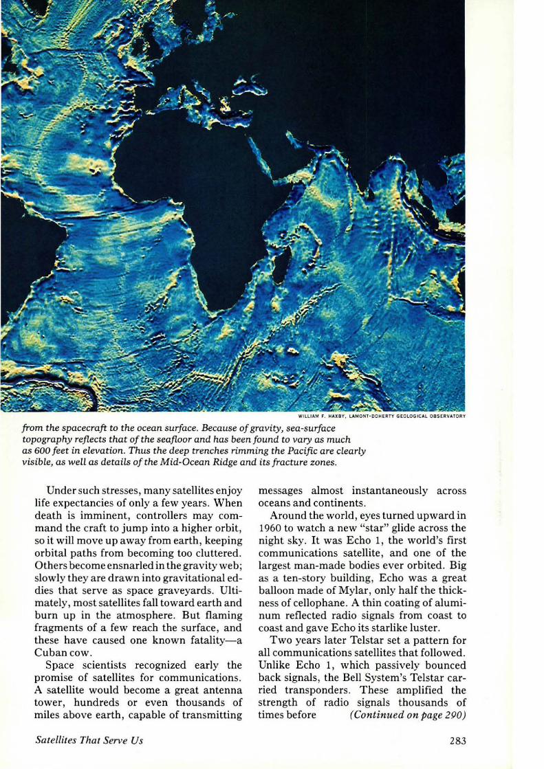
Millions of measurements by a radar altimeter were used to produce a relief map showing variations in the ocean surface. Installed on an oceanographic satellite called Seasat) the altimeter) built at the Jet PropuLsion Laboratory in Pasadena) California) recorded the distance
numbers change almost daily; anything can happen to satellites."
How true. For life in space is no picnic, even for a bunch of unfeeling machines.
Their perils begin with launch, which in the U.S. takes place at Cape Canaveral in Florida, NASA's Wallops Flight Center in Virginia, or, for polar orbiters, Vandenberg Air Force Base in California. One satellite in 20 is crippled by the jolt of lift-off, perishes in the inferno of a defective rocket blast, or is thrust into improper orbit. A few simply vanish into the immensity of space.
When a satellite emerges from the rocket's protective shroud, radiotelemetry regularly reports on its health to round-the-clock crews of ground controllers. They watch over the temperatures and voltages of the craft's electronic nervous system and other
282
vital organs, always critical with machines whose sunward side may be 300 degrees hotter than the shaded part.
Once a satellite achieves orbit- that delicate condition in which the pull of earth's gravity is matched by the outward fling of the craft's speed- subtle pressures conspire to lure it astray. Solar flares buffet the traveler, pushing it out of orbit. Wisps of outer atmosphere drag down its speed. Like strands of a celestial spiderweb, gravity fields of the earth, moon , and sun tug at the orbiting spacefarer. Even the sunshine's soft caress exerts a gentle nudge.
Should a satellite begin to wander, ground crews fire small fuel jets that steer it back on course. This is done sparingly, for exhaustion of these gases ends a craft's useful career.
National Geographic , September 1983
WI LLIAM f . HAXBY. LAMONT• DOHERTY GEOLOGICAL OBSERVATORY
from the spacecraft to the ocean surface. Because of gravity, sea-surface topography refl.ects that of the seafloor and has been found to vary as much as 600 feet in elevation. Thus the deep trenches rimming the Pacific are clearly visible, as well as details of the Mid-Ocean Ridge and its fracture zones.
Under such stresses, many satellites enjoy life expectancies of only a few years. When death is imminent, controllers may command the craft to jump into a higher orbit, so it will move up away from earth, keeping orbital paths from becoming too cluttered. Others become ensnarled in the gravity web; slowly they are drawn into gravitational eddies that serve as space graveyards. Ultimately, most satellites fall toward earth and burn up in the atmosphere. But flaming fragments of a few reach the surface, and these have caused one known fatality-a Cuban cow.
Space scientists recognized early the promise of satellites for communications. A satellite would become a great antenna tower, hundreds or even thousands of miles above earth, capable of transmitting
Satellites That Serve Us
messages almost instantaneously across oceans and continents.
Around the world, eyes turned upward in 1960 to watch a new "star" glide across the night sky. It was Echo 1, the world's first communications satellite, and one of the largest man-made bodies ever orbited. Big as a ten-story building, Echo was a great balloon made of Mylar, only half the thickness of cellophane. A thin coating of aluminum reflected radio signals from coast to coast and gave Echo its starlike luster.
Two years later Telstar set a pattern for all communications satellites that followed . Unlike Echo 1, which passively bounced back signals, the Bell System's Telstar carried transponders. These amplified the strength of radio signals thousands of times before (Continued on page 290)
283

Satellites on parade
THESE tireless servants have in a few
short years become indispensable tools in the service of communications, science, and defense .
I Sputnik 1 ( 195 7, U.S.S.R) beeped for 21 days and extended man's horizon to space.
2 Explorer 1 (1958, U. S.) discovered the existence of a radiation belt around the earth.
3 TIROS 1 (1960, U. S.) took and transmitted 22,952 images of earth's weather.
4 Echo 1 (1960, U.S.) relayed radio and TV.
5 Telstar l (1962, U.S.), the first communications satellite to transmit TV programs overseas.
6 Syncom 2 (1963, U.S.) achieved the first synchronous orbit above the earth.
7 OAO 2-Orbiting Astronomical Observatory

(1968, U.S.) turned i~< J 1 telescopes to the stars.
8 Vela 6 (1970, U. S.), orbiting as high as 70,000 miles, designed to detect nuclear explosiotl8.
9 InreU.at IV (1971), owned and o~rated by the International Telecommunicatioru SateUite Ofianlzation, relays telephone calls and television program.s.
10 ATS-6-Applicarions Technololt}' Satelli te (1974 , U. S.) brought TV to isolated communities.
II LACE OS- Laser Geodynamics Sa tel lite (1976, U.S.) plotted the movement of tectonic plates.
12 IUE -Intcmational Ultraviolet Explorer ( 1978, U.S., U. K., European Space Agency) peered deep into .o;pacc to invc.c;tigarc black holc.s and qua•ar<.
13 OSCAR8- 0rbiting Satellite Carrying Amateur Radio (1978, U.S.) relayed the signals of ham operators.
14 Landsat 4 (1982, U. S.) images earth's surface for geology, agriculture, bathymetry, and land use.
IS TDRS-Tracking and Data Relay Satellite ( 1983, r r <' \ : ... A ..... : ........ A . ... .... . .... ..
data between satellircs and earth slalions as fast as 300 million bits per second.
16 Spacelab I (1983, U. S.) will provide a laboratOl)' for cxpcrimcnfs in micro-gravity.
17 Space Telescope (1986 , U.S.) will extend scientists' eyes lO the fringes of the universe.
18 COBB - Co.<mic Backgratmd Explorer ( 1987, U.S.) will analyze the rudiution source& oft he universe to try to determi11e its eurfy structure.
19 GPS-Giobaf Positioning Syst~m. ur NavStar ( 1988, U.S.). This J 8-sa reUir~ sys tem will afford precise navigational data for the milirary.
20 UARS- Upper Atmusph.er~ Research Satellite ( 1989, U. S .) will <tudy how the atmosphere influences earth's weather.
21 OPEN- Origins of Plasmas in the Earth's Neighborhood (!989 , U. S.) w ill.o;tudy ionized gases .
286
••INl llltiUU.i~~H! IU , t:.ru , 0~11 11 , .u.c A.LIIhlt U or
SUflliHI UF.IIOTTO ICioLl

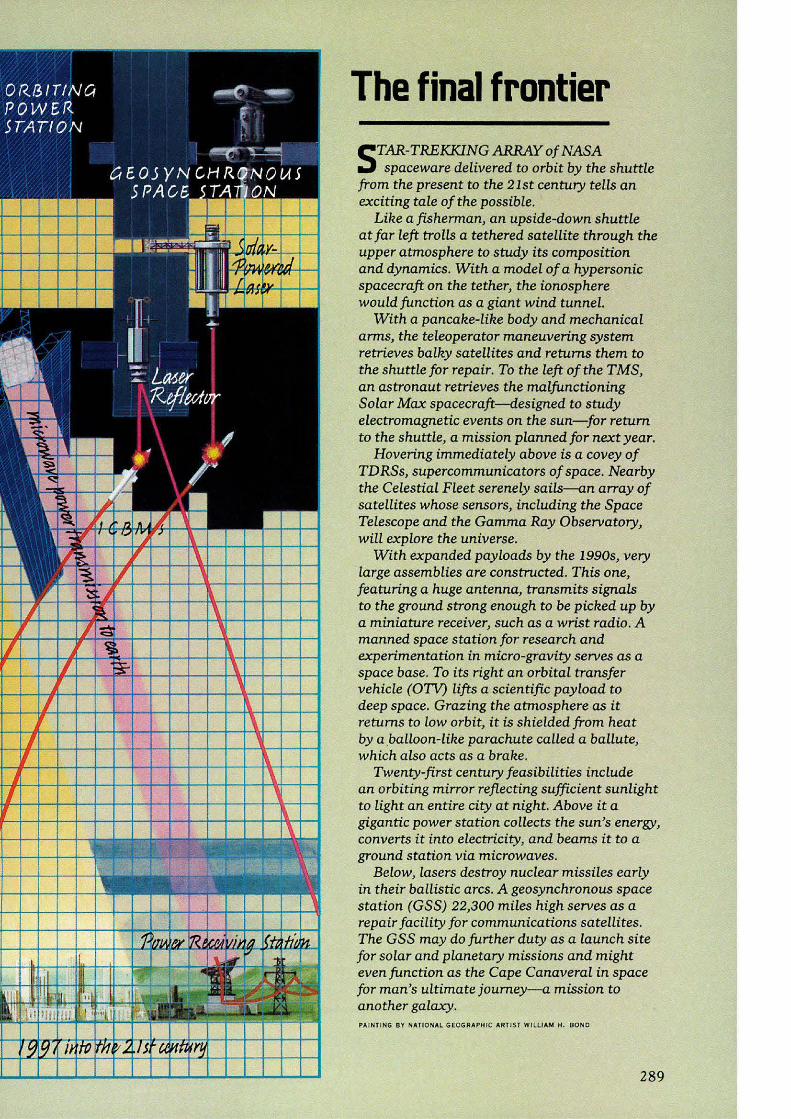
The final frontier
STAR-TREKKING ARRAY of NASA spaceware delivered to orbit by the shuttle
from the present to the 21st century tells an exciting tale of the possible.
Like a fisherman, an upside-down shuttle at far left trolls a tethered satellite through the upper atmosphere to study its composition and dynamics. With a model of a hypersonic spacecraft on the tether, the ionosphere would function as a giant wind tunnel.
With a pancake-like body and mechanical arms, the teleoperator maneuvering system retrieves balky satellites and returns them to the shuttle for repair. To the left of the TMS, an astronaut retrieves the malfunctioning Solar Max spacecraft-designed to study electromagnetic events on the sun-for return to the shuttle, a mission planned for next year.
Hovering immediately above is a covey of TDRSs, supercommunicators of space. Nearby the Celestial Fleet serenely sails-an array of satellites whose sensors, including the Space Telescope and the Gamma Ray Observatory, will explore the universe.
With expanded payloads by the 1990s, very large assemblies are constructed. This one, featuring a huge antenna, transmits signals to the ground strong enough to be picked up by a miniature receiver, such as a wrist radio. A manned space station for research and experimentation in micro-gravity serves as a space base. To its right an orbital transfer vehicle (OTV) lifts a scientific payload to deep space. Grazing the atmosphere as it returns to low orbit, it is shielded from heat by a balloon-like parachute called a ballute, which also acts as a brake.
Twenty-first century feasibilities include an orbiting mirror reflecting sufficient sunlight to light an entire city at night. Above it a gigantic power station collects the sun's energy, converts it into electricity, and beams it to a ground station via microwaves.
Below, lasers destroy nuclear missiles early in their ballistic arcs. A geosynchronous space station (GSS) 22,300 miles high serves as a repair facility for communications satellites. The GSS may do further duty as a launch site for solar and planetary missions and might even function as the Cape Canaveral in space for man's ultimate journey-a mission to another galaxy. PAINTING BY NAT IONA L GEOG RAPHIC AR TIST WILLIAM H. BONO
289

(Continued from page 283) relaying them to their destination.
But Telstar could relay messages only when its orbit placed it between the sender and the intended receiver. If only a satellite would hang stationary overhead , always in relaying position .. . .
A means for achieving this had been suggested by science writer Arthur C. Clarke as early as 1945 . If a satellite traveled 22,300 miles above the Equator, with an orbital period of 24 hours, it would remain stationary above a fixed point on earth's surface- an orbit known as geostationary. Today the geostationary belt is recognized as the most important orbital region around earth.
In 1965 an 85-pound fledgling known as Early Bird soared aloft from Cape Canaveral to stake man's claim on the geostationary frontier. Parked over the equatorial Atlantic, it relayed as many as 240 telephone calls at once between North America and Europe - more than six times as many as the Atlantic cable, laboriously completed nine years earlier. It also carried a TV channel. Through Early Bird, television viewers watching events an ocean away came to accept the startling words Live Via Satellite.
Early Bird had been built with a life expectancy of 18 months. Four years after launch, when a successor satellite failed, the Bird was brought out of retirement to broadcast the investiture of Great Britain's Prince of Wales to 500 million people.
Early Bird also provided the initial space link for a remarkable venture known as the International Telecommunications Satellite Organization, or Intelsat.
Today 15 satellites unite 109 Intelsat member nations in a communications brotherhood that sets a unique example of international cooperation. For the U. S. the participating agency is Comsat-the Communications Satellite Corporation. Immensely profitable to its members, Intelsat also has reduced the cost of worldwide telecommunications. Today costs are only oneeighteenth what they were before 1965.
Technologically, Intelsat's satellites are marvels of engineering.
In an ultraclean assembly room at Ford Aerospace & Communications Corporation in Palo Alto, California, Sam Eveleth
290
inspected my white smock, my white gauze cap, the gauze bootees covering my shoes. Approving, he said , "Duck inside."
Stooping, I straightened up within a desksize vehicle whose panel walls bristled with some 38,000 sensitive electronic parts.
"This is an Intelsat V, one of 15 we're turning out," said Mr. Eveleth . "They're the fifth generation, after Early Bird. Instead of 240 voice circuits, this one has twelve thousand, plus two color TV channels. But these birds are expensive- about 34 million dollars apiece.
"That's because everything's customized. For reliability, thousands of parts are made of exotic materials. See that nut?" He pointed to a small blue fastener surely worth only pennies. "It's made of titanium and costs $2 S. 7 5. That's what I mean, expensive."
LMOST EVERY MONTH another communications satellite parks in the geostationary belt: satellites called
Westars, to service Western Union and companies who lease its transponders; Comstars , flagships of mighty Comsat; Satcoms, built and owned by RCA; powerful Aniks, sent aloft by Canada to form the world's first domestic satellite system. Indonesia unites its thousand inhabited islands with satellites; Japan and the European Space Agency own orbiting communications stations; and aU. S. military network parallels Intelsat's . Most Soviet communications satellites travel highly inclined orbits to cover that nation's northern latitudes, or the geostationary belt would be even more crowded.
Despite this proliferation, demand for satellite communications outraces supply. Explained Robert C. Hall , president of Satellite Business Systems (SBS), "We are witnessing a shift of tidal proportions in the way we handle information, in the way we move it from place to place. And satellites are superb information handlers. " A typical SBS satellite channel can relay "talk" between computers about 160 times faster than is practical over landlines-fast enough to transmit Tolstoy's War and Peace across the U. S. in a few seconds.
Similar strides are taking place in the booming field of teleconferencing. This innovation grew out of the heartwarming exploits of a versatile experimental satellite
National Geographic, September 1983

labeled ATS-6, and known as the Teacher in the Sky.
Soon after launching the Teacher in 1974, NASA ground controllers trained its antenna on Appalachia. There it brought evening college classes to schoolteachers whose isolation denied opportunity for advancement.
When the day's classes ended in the East, controllers shifted the satellite's beam to the Rocky Mountain region. There it broadcast vocational courses to junior high students.
By then evening had reached the West Coast , and controllers tilted the Teacher again for the day's final task-delivering medical help to the Northwest and Alaska. In this region, where distances are vast and medical assistance sparse, the burly machine became an angel of mercy.
"For the medical experiments we used two-way television, " recalled Wasyl Lew, former ATS program manager. "Once, in Alaska, an Athapaskan Indian working at a remote construction site had his face horribly torn-the cheek ripped open from
Visionary genius, artist Chester Gould anticipated the feats of the space age with eLan, if not exactitude. In the 1940s, when many astronauts were stiLl in diapers, Gould's superdetective Dick Tracy and his scientist cohort, Diet Smith, roamed the universe in an atomic-powered Space Coupe and used lasers to process gold on the moon.
Tracy first employed his two-way wrist radio in the service of justice on january 20, 1946. A more advanced version also included a 1V receiver (below) , used by Tracy to communicate with authorities on the moon.
Gould's imagination still outstrips current technology. From his retirement home in W oods tock, Illinois, he says, ((I still think that getting around the universe will be a simple thing someday."
Satellites That Serve Us
mouth to temple. The wound froze right away, but when people took him inside to help him, it thawed, and he began to bleed to death.
"A health aide used ATS-6 to contact a doctor in Anchorage and showed him the cut over television. Right away he had her sewing up the wound, directing every stitch over TV. The patient did fine."
After a year controllers drifted the Teacher eastward, to within beaming range of India. There officials already had begun construction of 2,400 chicken-wire antennas in as many villages.
Each evening after the men came in from the fields, the satellite sent down programs on agriculture, health, and family planning to throngs who never before had seen television. This success launched India on her own satellite program.
By now it was 1976. As NASA controllers guided the Teacher's slow return westward , it helped celebrate our Bicentennial by carrying the story of space benefits to Asia,
29 1

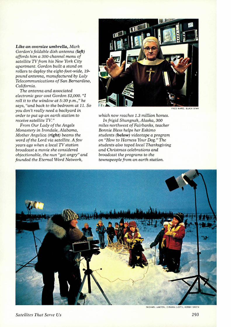
Like an oversize umbrella, Mark Gordon's foldable dish antenna (left) affords him a 300-channel menu of satellite TV from his New York City apartment. Gordon built a stand on roLLers to deploy the eight-foot-wide, 19-pound antenna, manufactured by Luly Telecommunications of San Bernardino, California.
The antenna and associated electronic gear cost Gordon $2,000. "I roll it to the window at 5:30p.m.," he says, "and back to the bedroom at 11. So you don't reaLly need a backyard in order to put up an earth station to receive sateLLite TV."
From Our Lady of the Angels Monastery in Irondale, Alabama, Mother Angelica (right) beams the word of the Lord via satellite. A few years ago when a local TV station broadcast a movie she considered objectionable, the nun "got angry" and founded the Eternal Word Network,
Satellites That Serl'e Us
which now reaches 1.3 million homes. In frigid Shungnak, Alaska, 300
miles northwest of Fairbanks, teacher Bonnie BLess helps her Eskimo students (below) videotape a program on "How to Harness Your Dog." The students also taped local Thanksgiving and Christmas celebrations and broadcast the programs to the townspeople from an earth station.
FRED WARD. BLACK STAR
\11CHA£L LA WJON , CIRAMA (LEn); KERBY SMIT~
293

Africa, Europe, a nd South America. Back home again, ATS-6 diligently resumed its good works over Appalachia, the Rocky ·Mountain region, and the Northwest. By 1980, its steering thrusters spent, the Teacher was granted a well-earned retirement.
Its legacy of teleconferencing was born of the Teacher's lesson that distant individuals can react with intimacy when brought together by satellite-borne TV. Today a growing number of professions are abandoning costly travels to a common meeting place, and instead meet "face-to-face" through television .
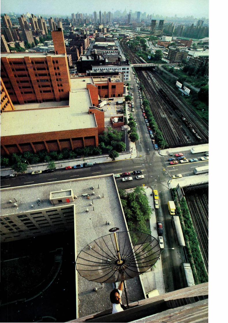
Scan the office-building rooftops in your hometown and count the dish antennas, turned like sunflowers to the heavens. Many form the connecting link between communications satellites and one oftheir major customers, the nation's more than 5,600 cable-television franchises.
A few years ago cable television lolled in the doldrums, a poor relation to the mighty broadcast networks that blanket the na tion using telephone lines and microwave towers. Then satellites vaulted community a ntenna television (CATV) into dazzling visibility. Home Box Office (HBO) persuaded cable companies to erect dishes to relay recent movies to home TV. About the same time another satellite ventu re blasted offthe inspiration of an audacious Atlanta entrepreneur.
"It came to me while I was reading a magazine story about satellites," said Ted Turner, as he adjusted a large tobacco chew. "I owned a television studio; towns a ll across the country had cable-TV systems; and in the sky hung a satellite that could bring us together. Throw in a system of earth stations, and I'd have a nationwide cable system able to take on the national networks that are bringing us so much trash. "
Ejecting his quid of Red Man, Mr. Turner lit a large, dark cigar. "Now a satellite carries my superstation WTBS to 26 million households ac ross the nation, and we're challenging the networks. By 1985 cable TV will be in half our homes."
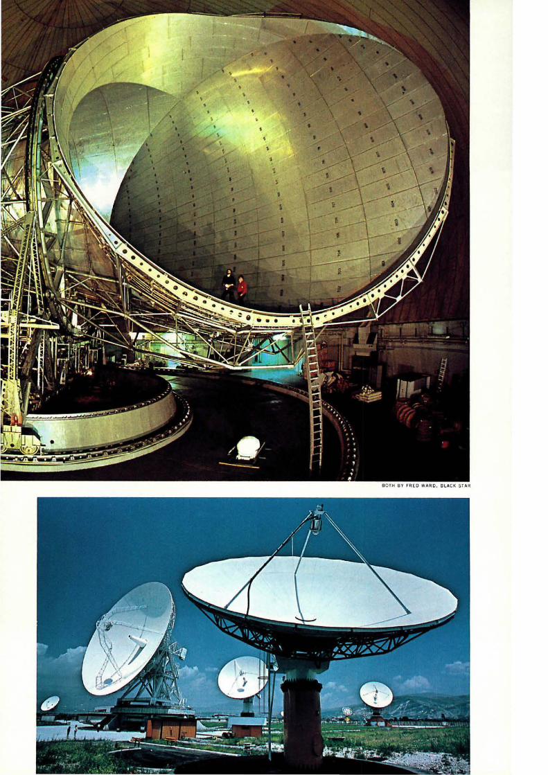
The burgeoning of cable television has inspired a tandem boom in earth antenna stations. Scientific-Atlanta, Inc. (S-A), the world's largest antenna manufacturer, was riding high on this wave of the future when
294
Paul Bunyan's earphone, the 380-ton antenna at the Andover, Maine, earth station (above) went into service in 1962. Known as Big Hom, the giant antenna linked the United States with Europe "live via satellite" through the famous Early Bird.
With the miniaturization revolution of the 1970s, Big Hom was deactivated, only to be resun·ected for the Defense Department last year to provide telecommunications with the island of Diego Garcia in the Indian Ocean.
Modem dish antennas at Fucino, Italy (right), perform tests of newLy launched Intelsat sa tellites, as weLl as telemetry, tracking, and command functions.
National Geographic, September /983
BOI >i BY f~[O WA RO, BLACK S TAR
296
Chatting at light speed
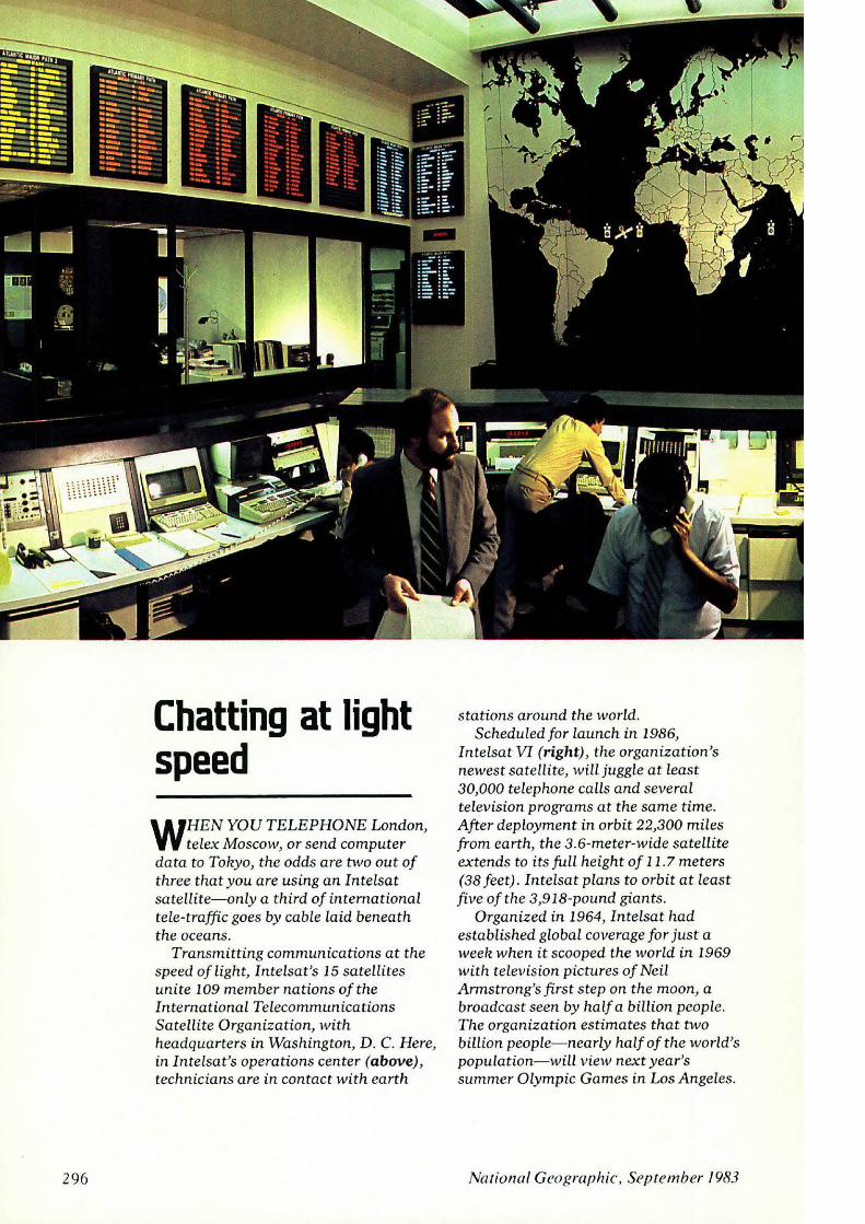
WH EN YOU TELEPHONE London, telex Moscow, or send computer
data to Tokyo, the odds are two out of three that you are using an Intelsat satellite-only a third of international tele-traffic goes by cable la id beneath the oceans.
Transmitting communications at the speed of light, Intelsat's 15 satellites unite 109 member nations of the International Telecommunications Satellite Organization, with headquarters in Washington, D. C. Here, in Intelsat's operations center (above), technicians are in contact with earth
stations around the world. Scheduled for launch in 1986,
Intelsat VI (right), the organization's newest satellite, will juggle at least 30,000 telephone calls and several television programs at the same time. After deployment in orbit 22,300 miles from earth, the 3.6-meter-wide satellite extends to its full height of 11.7 meters (38 feet). I ntelsat plans to orbit at least five of the 3,918-pound giants.
Organized in 1964, Intelsat had established global coverage for just a week when it scooped the worLd in 1969 with television pictures of Neil Armstrong's first step on the moon, a broadcast seen by half a billion people. The organization estimates that two billion people- nearly half of the world's population-will view next year's summer Olympic Games in Los Angeles.
National Geographic , September 1983

MICHAEL lAWTON, CIRAMA
PAINTING OY LLOYD K. TOWNSEND ( ASTRONAUT SHOWN TO SCAl.E)
Satellites That Serve Us 297

I came call ing at its plant in Georgia. "Vie have made more than 10,000 dish
es, " said J ohn Feight as he showed me S-A's anthill of electronics activity. "You used to need an antenna a bout 30 feet in d iameter that cost $100,000. Today a ten-foo ter gives good reception, and mass production reduces the cost to a round ~6,000-cheap
enough to park in the backyard. " Backyard users a rc responding- both
those who live beyond reach of regula r T V and those who delight in aiming an antenna toward a d istant satellite and harvesting scores of programs free for the taking.
But w hat is the legality and morality of collecting T V signals intended only for paying customers? "Piraci" charge pay-T V networks such as H BO; and as home dishes spread , they plan to scramble their signals so una uthorized users can't decipher them. H ome antenna owners counter that what they do in their backyards is their own business , although many would pay if billed.
The issue could become more complex with the impendin(T a rrival of a new generation of television, known as direct broadcast sa tellite, or DBS. H ere, powerful satellites would beam T V directly to miniaturized rooftop antennas costing only a few hundred dolla rs.
For mariners , satellites can mean life itself. vVhen the liner Titanic sm ashed into an Atlantic iceberg in 1912, another ship sailed nearby but had turned off its radio and did not hear the Titanic's frantic calls. As a result, 1,5 17 persons died . The tragedy spurred 24-hour radio watch, although interference still plagued communications.
Radio reliability was revolutionized w ith the birth of a marine satellite system now known as Inmarsat , the International Maritime Satellite Organization . Today three internationally operated sa tell ites provide instantaneous communication fo r a fastgrowing fleet of nearly 2,000 ships that carry Inmarsat equipment.
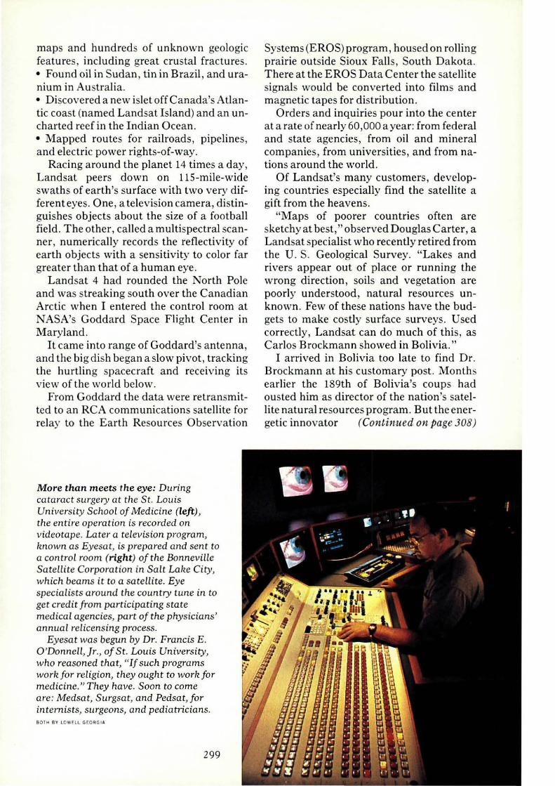
MORE THAN a decade ago N ASA launched a sa tellite whose electronic eyes were designed to examine the
planet's surface from 5 70 miles above. The spacecraft, known today as Landsat , had its skeptics: What could a machine at high altitude tell us that a person couldn 't see bette r on the ground ?
Landsat 1 and three successor satellites responded with some of the most exciting rewards of man's venture into space. Guided by their imagery, analysts have: • Located scores of lakes that show on no

maps and hundreds of unknown geologic features, including great crustal fractures. • Found oil in Sudan , tin in Brazil , and uranium in Australia. • Discovered a new islet off Canada's Atlantic coast (named Landsat Island) and a n uncharted reef in the Indian Ocean. • Mapped routes for railroads, pipelines, and electric power rights-of-way.
Racing around the planet 14 times a day, Landsat peers down on 115-mile-wide swaths of earth's surface with two very differenteyes. One, a television camera, distinguishes objects about the size of a football field. The other, called a multispectral scanner, numerically records the reflectivity of earth objects with a sensitivity to color fa r greater than that of a human eye.
Landsat 4 had rounded the North Pole and was streaking south over the Canadian Arctic when I entered the control room at NASA's Goddard Space Flight Center in Maryland .
It came into range of Goddard's antenna, and the big dish began a slow pivot , tracking the hurtling spacecraft and receiving its view of the world below.
From Goddard the data were retransmitted to an RCA communications satellite for relay to the Earth Resources Observation
More than meets the eye: During cataract surge1y at the St. Louis University School of Medicine (left), the entire operation is recorded on videotape. Later a television program, known as Eyesat, is prepared and sent to a control room (right) of the Bonneville Satellite Corporation in Salt Lake City, which beams it to a satellite. Eye specialis ts around the country tune in to get credit from participating state medical agencies, part of the physicians' annual relicensing process.
Eyesat was begun by Dr. Francis E. O'Donnell, Jr., of St. Louis University, who reasoned that, "If such programs work for religion, they ought to work for medicine." They have. Soon to come are: Medsat, Surgsat, and Pedsat, for internists, surgeons, and pediatricians. BOIH BY LO Wf l l GCO RGI A
299
Systems (EROS) program, housed on rolling prairie outside Sioux Falls, South Dakota. There at the EROS Data Center the satellite signals would be converted into films and magnetic tapes for dist ribution.
Orders and inquiries pour into the center at a rate of nearly 60,000 a year: from federal and state agencies, from oil and mineral companies, from universities, and from nations around the world.
Of Landsat's many customers, developing countries especially find the satellite a gift from the heavens.
"Maps of poorer countries often are sketchy at best ," observed Douglas Carter, a Landsat specialist who recently retired from the U. S. Geological Survey. "Lakes and rivers appear out of place or running the wrong direc tion, soils and vegetation are poorly understood, natural resources unknown. Few of these nations have the budgets to make costly surface surveys. Used correctly, Landsat can do much of this, as Carlos Brockmann showed in Bolivia."
I arrived in Bolivia too late to find Dr. Brockmann at his customary post. Months earlier the !89th of Bolivia 's coups had ousted him as director of the nation's satellite natural resources program. But the energetic innovator (Continued on page 308)

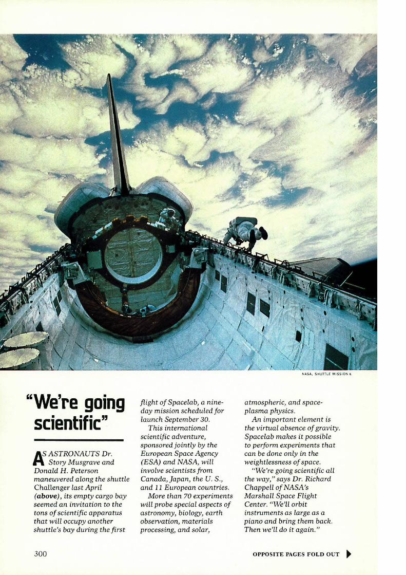
"We're going scientific" AS ASTRONAUTS Dr. 1-\ Story Musgrave and Donald H. Peterson maneuvered along the shuttle Challenger last April (above), its empty cargo bay seemed an invitation to the tons of scientific apparatus that will occupy another shuttle's bay dw-ing the first
300
flight of Spacelab, a nineday mission scheduled for launch September 30.
This international scientific adventure, sponsored jointly by the European Space Agency (ESA) and NASA, will involve scientists from Canada, japan, the U. S., and 11 European countries.
More than 70 experiments w ill probe special aspects of astronomy, biology, earth observation, materials processing, and solar,
NASA, SH UTTLE M ISS ION 6
atmospheric, and spaceplasma physics.
An important element is the virtual absence of gravity. Spacelab makes it possible to perform experiments that can be done only in the weightlessness of space.
'We're going scientific all the way/' says Dr. Richard ChappeLl of NASA's Marshall Space Flight Center. ((We'll orbit instruments as large as a piano and bring them back. Then we'll do it again. "
OPPOSITE PAGES FOLD OUT ~

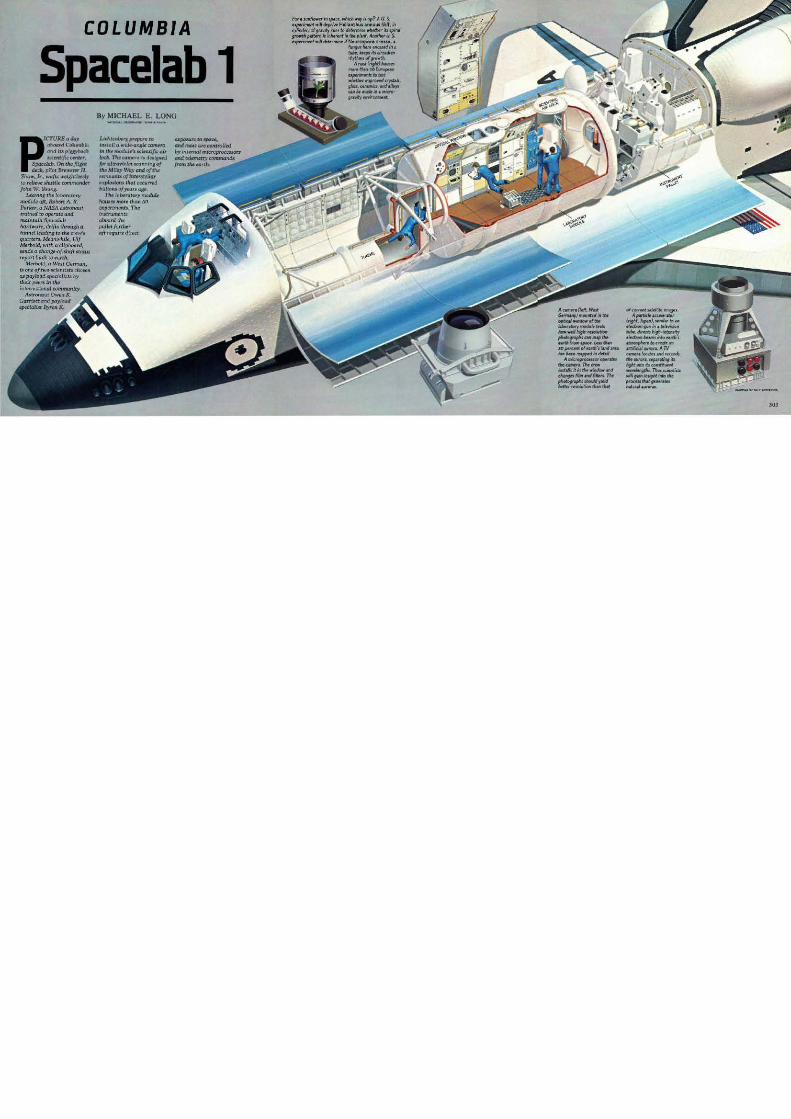
COLUMBIA
Spacelab 1
Rlcrt/RSo4o,
(lbocmfc..:oiNMbU. (lftdlt• pf.tiD'b.kll: JCLeilltl,(U:~. _O. ... j!J;of ---H. S'wi•, fr., ~-.igh~·
1o rdNw Murdc oom."WW"*r JoMW.Yowt~&
1--."'•S tlliflaNINtcr)' IIIOCfu!c~Vt,ltobmA.R
PorlNr, a .'VASA a.tnwJut rruilled' to aperarc ond ~Spu...,.Wb ltaldw.lft',drljb; ~ile ftmllt-fieadlfll rotlw c•cl¥'t quarten . .HeanwhiJio, r Jlf MtrbokL wicfl 111 dlpbc»hf, .Wad&onae-of·MU'•tczt.u ~*ltWIJI.Irth,
Ml!rfrofr!, a WifJf (;..mum. t.mu:ttfn..'(lk"ft'lltimdloam Q.l pq)locld 'PMQluU"" fMVJ*~~fllw lntrmationGI ~to "'~":u-nit
Gan-uttta-wlpqlaod tpCdafile"""' lC.
By MICHAEL E. LONU --- ... -····-w.c.-.,.F"f'G'WIU UttJallew..Je.uii,IIWC~UMra
illtfN-MO<fylir'•~cW r.d. llle~i.lcfUr,wd
/M ul""*"lcr-""'l"'of tiMAitfV~Oftlfo/IM ~ulbuantd.klr
~··~ bWionl OJ,...,.. YiP , .... ,.Nrotor,r"""'* ,..,.._MIW'CtflonM MJK!~.n. ............ u
"""""'"" pulktjiJ.rdwr aftrcqui••dlr«l

Space partners: ESA and NASA
A':!~~ms do-'"" t:arr~'.s mOJ"etk fU!IJ. I'"= the ll'::~r::e to C<lu.wlrCrt#t'l~.4
daccror (WutG~) mNJVru t."ldtnamben, aptm,.. and duubo"'.
Tne~corolllll)' u.prrim.mt(~).ll s.t"UOrlk!'.narfll: lnunuzycnd'dlmrionof ftlfih'A~fKidin rhericirlieyofrlt•ll;.,rr;.
U.hrw•'$p0ptrt. X nu-s erti.Ued bJ' wolrop.~...ulnornc.fmrl~rn~ r;up~ropu~
CCI")'tltetfo:Joriu<t{r~ eventJ,b«aw;eatc P~•thu!Wi..o:ed th..miD./M / tJw IU)'I wtrl\ di«'rmjreq~tr"~du . .A ~fl"XItC.l'!W: 1tr{f)llr'Oj;l<tAII
SpaceA.rency) ediu tl'l~ CVVY from '"'--h ft'{Nf lt'•t cuoo!lidinastars<~.nd
b~ud1 ltu!e~ 111 f.ml<.h~c Y puptr that U$lmrwmers will read Willi lnttrU I.
Yi~w~d from Nmttl.-. a/rirude,rMarm~phtrt'
<lN•Wreo,s:iou/ tele~uion..scr~n.
t."O'It<lmi~fuin.tuptkuJ tml_'I.~LOI'IA pmduaod Dy h~ll-~'1!1oci!) ll.'iod.,
"''
tl~lric fkldi. o.nd other phenulrwllol.l . • •.,!!.n (.1 w~ .. lrJI!r 'IV rmr..,... (t : nim:l Suua)r«o'1fsr~
i~, t"Urtl:l.ou:~ral
Kttnlutll a:11 huu:"' at rht!rldatre..
'fll.r;A:ut'lJrcJ&!iant
~imr.bio-06' tho>.oklrQ)I'U:.::~~r
pu.-W out atmmpht.te, eoouribu!V.trodle "'}UUIS'IruthattpWn:
amt01phoic dmtlcltioll. Gtl4~teo.rth'sdinu;ue.
Wilh.~IUd:i.lco\.'Criu lhultf,.,lilltw-.._oo.u.:ml cu:tuu!..!)owriuo.bi(, Wntf£u otlr, /':.owm:.:dl7 Thtql.l~'lc.anr.nlylx
Gn.l'4otr«ffro"'g lpclce.:rllft,~i<Jcelht
GI!"'!OSpllereftiletSOO! '~o{lhe,un'•.mero· fH:jnrE u ,,aches earth. :\ radiallCe f rmor (1\elgtum)t~.'i/lhelp
delermmcthc:mric;:bilil;y o.fl/,.,1'\l/, .. oo,l>~I"' 'L
A.ll.'lteri::.Q)t'nrm:nt ( FJ'Iln.ee)vifwl a n~rro,..tr ~liu<'ftht
IW\'1 ene'l)' output. frv "l llltra•·•ull.'t tv m.frnr£d-,.pcctro.l lw:~
th:~:depw;it t'rw'X)'ut WJriO'l!l., /1"\'>!/.otl.f t/v.
ctn"losph~e.
Physiology
HJ.~~:~~=~~M hasal11biu:.lcurw>ut l!ya.,rwa:tWm I!W'ltlj!: p~~ftlfllt.M uperlt...ud (rm'IWr tnt pi!otbca:Jmcs..:16HG!«L ll~ lxan olte:s in ,.,.,-:~vn. fir iNc• rN b!oodcdlJ.\""'fl
A1VCilrlftUO/W')
hiihruolu.riPnlttOunlird Cf1 a cnw nvmkn htad ~Jtl willncordtht r.omnmtof"bqu whiltltcoia»ln.IJPI'Ilinu r.cta!framt.,u'\:cr,and ~Pltdcaboul/)y.:Mffuor
CffW "•.,r,,Y ... 1\"n•{c ey~mowmenrtore a~~Q i•t.Ju IONoi!Jilech.:HI&,_ t'tlhebod,:/scklloate balann>l.)'lit tm.
Ata1WI.I'M:rlimc,hc "'IUbco'WikJ l()ltlJdyi~C lnl".l'lrinr•nfromll'll'l:1 siiCPfl'Cind, wftl'l 1!.)-e.$
c/uit'd,jiOiltl IOtloleh.
A hemotlobin rncmhor '1!conl'ld:all8et~i1lred·
I:IOc>d~dtproducriOr:,
and a rruodlcal rape rYconlt•,tb 'OII,IJ'h ~~~ctrodn4~ . ....., In blac.~. •nOtlitor:s 1•:.h«<rt, ~nun. o.ndeyt•.
l~tc.IUHIIier c.~pt!nl?ltlll
hcpKb upu pcir lt/rr:ctul b.a/Licr."'dtrHAfOjulf:ll whith u ~.cc: ...... r. nw" are ;~c bolita IG dloo$e .f-om,o.llrhfaome•t:ebur d~1wbt/,vmmu.u.
A slfl,'ll ci«rrk Moc.'t applUcflolht hbl.cCnti"'>C. bd:lnd rll.r -."We wfU y~(i(f'1'•"~-'"wwr<~tinl_,·
'tii0Wnt'lrido(N1"1u. Mt:nW''Ir d11n"n1 AJU.t.UIItd '4vW'tdcur.eu.
Al.v.!n{tllcu croairnmu •IU a!.o b.r cn.V..Cr.r..:i lx/on CUIJ o/kt L't.rJI!Jht.
John W . YOW!f c-merwW "~- .-.: .. ;.,.., ... eopi'Mt'tal ldl.pit.l, Y-1· SJto.-.-.N~MAtc •rAfiU~or!.hlksrfi:JM inMtrlottor'tr""'.:,.. .. &.;,...; .. -cc-~~ tPfllt--.~Jt4c..·n .... t!trc~'srlf«-t
&rewu.r H. SN.w, Jr. -A• .. A•Fvtvr,.-..pih(. Sf.JW,H. ~flwc~ra, c;...,wfttwQIH~
... ~'*"n,..,;.IOOIJ ~HI•J.-!V"!II:f._.. &fwnbomwnry .. ..,...., .. l'fJe. .V ..-•»ttJ:~.M!i"..o:~~W .. Ec.iiiiM""'otct&w
Or. Owafl K. G.lrriott MllsionS~Ie.lill
GM'!"!!t'~ Sl tcrwd u tueMe pif« on !hfJ«~~crfW :"1"1 A _,.~·.r..rm ,·-~'("f'..,.,;n,,..•r.r;...,.f lin doclorlh fr- Su.llford Ulliwflity o'II I'I6CJ
Or.RobtrtA. R. l"ark•r Mlnio~ SpKI•Ii5t A lottrter u~lltf prohnor uf• llfUtiOII., ~~i tt,. Ui"""""~ oi W/Jcc.Mili,PirA.t,"li. r.a~ "'' doc:to,.rr J, that •lib)«lftOh<INGIJifOfl'il II'IJt'fulcofTrdw;logylfl/96.2.
Or. i~ron 1<. U<:htanb• '1 P• tlo•dSp«LI! in A~Df'<U.':U .'a~ll , ..,;_;,..,, Uchk •• rg. Ji, 11.-Hgrm~tr<:""' U..w""1udtf.• ""-"---"·~el ,........,


Like an oversize umbrella, Mark Gordon's foldable dish antenna (left) affords him a 300-channel menu of satellite TV from his New York City apartment. Gordon built a stand on roLLers to deploy the eight-foot-wide, 19-pound antenna, manufactured by Luly Telecommunications of San Bernardino, California.
The antenna and associated electronic gear cost Gordon $2,000. "I roll it to the window at 5:30p.m.," he says, "and back to the bedroom at 11. So you don't reaLly need a backyard in order to put up an earth station to receive sateLLite TV."
From Our Lady of the Angels Monastery in Irondale, Alabama, Mother Angelica (right) beams the word of the Lord via satellite. A few years ago when a local TV station broadcast a movie she considered objectionable, the nun "got angry" and founded the Eternal Word Network,
Satellites That Serl'e Us
which now reaches 1.3 million homes. In frigid Shungnak, Alaska, 300
miles northwest of Fairbanks, teacher Bonnie BLess helps her Eskimo students (below) videotape a program on "How to Harness Your Dog." The students also taped local Thanksgiving and Christmas celebrations and broadcast the programs to the townspeople from an earth station.
FRED WARD. BLACK STAR
\11CHA£L LA WJON , CIRAMA (LEn); KERBY SMIT~
293
Africa, Europe, a nd South America. Back home again, ATS-6 diligently resumed its good works over Appalachia, the Rocky ·Mountain region, and the Northwest. By 1980, its steering thrusters spent, the Teacher was granted a well-earned retirement.
Its legacy of teleconferencing was born of the Teacher's lesson that distant individuals can react with intimacy when brought together by satellite-borne TV. Today a growing number of professions are abandoning costly travels to a common meeting place, and instead meet "face-to-face" through television .
Scan the office-building rooftops in your hometown and count the dish antennas, turned like sunflowers to the heavens. Many form the connecting link between communications satellites and one oftheir major customers, the nation's more than 5,600 cable-television franchises.
A few years ago cable television lolled in the doldrums, a poor relation to the mighty broadcast networks that blanket the na tion using telephone lines and microwave towers. Then satellites vaulted community a ntenna television (CATV) into dazzling visibility. Home Box Office (HBO) persuaded cable companies to erect dishes to relay recent movies to home TV. About the same time another satellite ventu re blasted offthe inspiration of an audacious Atlanta entrepreneur.
"It came to me while I was reading a magazine story about satellites," said Ted Turner, as he adjusted a large tobacco chew. "I owned a television studio; towns a ll across the country had cable-TV systems; and in the sky hung a satellite that could bring us together. Throw in a system of earth stations, and I'd have a nationwide cable system able to take on the national networks that are bringing us so much trash. "
Ejecting his quid of Red Man, Mr. Turner lit a large, dark cigar. "Now a satellite carries my superstation WTBS to 26 million households ac ross the nation, and we're challenging the networks. By 1985 cable TV will be in half our homes."
The burgeoning of cable television has inspired a tandem boom in earth antenna stations. Scientific-Atlanta, Inc. (S-A), the world's largest antenna manufacturer, was riding high on this wave of the future when
294
Paul Bunyan's earphone, the 380-ton antenna at the Andover, Maine, earth station (above) went into service in 1962. Known as Big Hom, the giant antenna linked the United States with Europe "live via satellite" through the famous Early Bird.
With the miniaturization revolution of the 1970s, Big Hom was deactivated, only to be resun·ected for the Defense Department last year to provide telecommunications with the island of Diego Garcia in the Indian Ocean.
Modem dish antennas at Fucino, Italy (right), perform tests of newLy launched Intelsat sa tellites, as weLl as telemetry, tracking, and command functions.
National Geographic, September /983

BOI >i BY f~[O WA RO, BLACK S TAR

296
Chatting at light speed
WH EN YOU TELEPHONE London, telex Moscow, or send computer
data to Tokyo, the odds are two out of three that you are using an Intelsat satellite-only a third of international tele-traffic goes by cable la id beneath the oceans.
Transmitting communications at the speed of light, Intelsat's 15 satellites unite 109 member nations of the International Telecommunications Satellite Organization, with headquarters in Washington, D. C. Here, in Intelsat's operations center (above), technicians are in contact with earth
stations around the world. Scheduled for launch in 1986,
Intelsat VI (right), the organization's newest satellite, will juggle at least 30,000 telephone calls and several television programs at the same time. After deployment in orbit 22,300 miles from earth, the 3.6-meter-wide satellite extends to its full height of 11.7 meters (38 feet). I ntelsat plans to orbit at least five of the 3,918-pound giants.
Organized in 1964, Intelsat had established global coverage for just a week when it scooped the worLd in 1969 with television pictures of Neil Armstrong's first step on the moon, a broadcast seen by half a billion people. The organization estimates that two billion people- nearly half of the world's population-will view next year's summer Olympic Games in Los Angeles.
National Geographic , September 1983

MICHAEL lAWTON, CIRAMA
PAINTING OY LLOYD K. TOWNSEND ( ASTRONAUT SHOWN TO SCAl.E)
Satellites That Serve Us 297

I came call ing at its plant in Georgia. "Vie have made more than 10,000 dish
es, " said J ohn Feight as he showed me S-A's anthill of electronics activity. "You used to need an antenna a bout 30 feet in d iameter that cost $100,000. Today a ten-foo ter gives good reception, and mass production reduces the cost to a round ~6,000-cheap
enough to park in the backyard. " Backyard users a rc responding- both
those who live beyond reach of regula r T V and those who delight in aiming an antenna toward a d istant satellite and harvesting scores of programs free for the taking.
But w hat is the legality and morality of collecting T V signals intended only for paying customers? "Piraci" charge pay-T V networks such as H BO; and as home dishes spread , they plan to scramble their signals so una uthorized users can't decipher them. H ome antenna owners counter that what they do in their backyards is their own business , although many would pay if billed.
The issue could become more complex with the impendin(T a rrival of a new generation of television, known as direct broadcast sa tellite, or DBS. H ere, powerful satellites would beam T V directly to miniaturized rooftop antennas costing only a few hundred dolla rs.
For mariners , satellites can mean life itself. vVhen the liner Titanic sm ashed into an Atlantic iceberg in 1912, another ship sailed nearby but had turned off its radio and did not hear the Titanic's frantic calls. As a result, 1,5 17 persons died . The tragedy spurred 24-hour radio watch, although interference still plagued communications.
Radio reliability was revolutionized w ith the birth of a marine satellite system now known as Inmarsat , the International Maritime Satellite Organization . Today three internationally operated sa tell ites provide instantaneous communication fo r a fastgrowing fleet of nearly 2,000 ships that carry Inmarsat equipment.
MORE THAN a decade ago N ASA launched a sa tellite whose electronic eyes were designed to examine the
planet's surface from 5 70 miles above. The spacecraft, known today as Landsat , had its skeptics: What could a machine at high altitude tell us that a person couldn 't see bette r on the ground ?
Landsat 1 and three successor satellites responded with some of the most exciting rewards of man's venture into space. Guided by their imagery, analysts have: • Located scores of lakes that show on no
maps and hundreds of unknown geologic features, including great crustal fractures. • Found oil in Sudan , tin in Brazil , and uranium in Australia. • Discovered a new islet off Canada's Atlantic coast (named Landsat Island) and a n uncharted reef in the Indian Ocean. • Mapped routes for railroads, pipelines, and electric power rights-of-way.
Racing around the planet 14 times a day, Landsat peers down on 115-mile-wide swaths of earth's surface with two very differenteyes. One, a television camera, distinguishes objects about the size of a football field. The other, called a multispectral scanner, numerically records the reflectivity of earth objects with a sensitivity to color fa r greater than that of a human eye.
Landsat 4 had rounded the North Pole and was streaking south over the Canadian Arctic when I entered the control room at NASA's Goddard Space Flight Center in Maryland .
It came into range of Goddard's antenna, and the big dish began a slow pivot , tracking the hurtling spacecraft and receiving its view of the world below.
From Goddard the data were retransmitted to an RCA communications satellite for relay to the Earth Resources Observation
More than meets the eye: During cataract surge1y at the St. Louis University School of Medicine (left), the entire operation is recorded on videotape. Later a television program, known as Eyesat, is prepared and sent to a control room (right) of the Bonneville Satellite Corporation in Salt Lake City, which beams it to a satellite. Eye specialis ts around the country tune in to get credit from participating state medical agencies, part of the physicians' annual relicensing process.
Eyesat was begun by Dr. Francis E. O'Donnell, Jr., of St. Louis University, who reasoned that, "If such programs work for religion, they ought to work for medicine." They have. Soon to come are: Medsat, Surgsat, and Pedsat, for internists, surgeons, and pediatricians. BOIH BY LO Wf l l GCO RGI A
299
Systems (EROS) program, housed on rolling prairie outside Sioux Falls, South Dakota. There at the EROS Data Center the satellite signals would be converted into films and magnetic tapes for dist ribution.
Orders and inquiries pour into the center at a rate of nearly 60,000 a year: from federal and state agencies, from oil and mineral companies, from universities, and from nations around the world.
Of Landsat's many customers, developing countries especially find the satellite a gift from the heavens.
"Maps of poorer countries often are sketchy at best ," observed Douglas Carter, a Landsat specialist who recently retired from the U. S. Geological Survey. "Lakes and rivers appear out of place or running the wrong direc tion, soils and vegetation are poorly understood, natural resources unknown. Few of these nations have the budgets to make costly surface surveys. Used correctly, Landsat can do much of this, as Carlos Brockmann showed in Bolivia."
I arrived in Bolivia too late to find Dr. Brockmann at his customary post. Months earlier the !89th of Bolivia 's coups had ousted him as director of the nation's satellite natural resources program. But the energetic innovator (Continued on page 308)
"We're going scientific" AS ASTRONAUTS Dr. 1-\ Story Musgrave and Donald H. Peterson maneuvered along the shuttle Challenger last April (above), its empty cargo bay seemed an invitation to the tons of scientific apparatus that will occupy another shuttle's bay dw-ing the first
300
flight of Spacelab, a nineday mission scheduled for launch September 30.
This international scientific adventure, sponsored jointly by the European Space Agency (ESA) and NASA, will involve scientists from Canada, japan, the U. S., and 11 European countries.
More than 70 experiments w ill probe special aspects of astronomy, biology, earth observation, materials processing, and solar,
NASA, SH UTTLE M ISS ION 6
atmospheric, and spaceplasma physics.
An important element is the virtual absence of gravity. Spacelab makes it possible to perform experiments that can be done only in the weightlessness of space.
'We're going scientific all the way/' says Dr. Richard ChappeLl of NASA's Marshall Space Flight Center. ((We'll orbit instruments as large as a piano and bring them back. Then we'll do it again. "
OPPOSITE PAGES FOLD OUT ~
COLUMBIA
Spacelab 1
Rlcrt/RSo4o,
(lbocmfc..:oiNMbU. (lftdlt• pf.tiD'b.kll: JCLeilltl,(U:~. _O. ... j!J;of ---H. S'wi•, fr., ~-.igh~·
1o rdNw Murdc oom."WW"*r JoMW.Yowt~&
1--."'•S tlliflaNINtcr)' IIIOCfu!c~Vt,ltobmA.R
PorlNr, a .'VASA a.tnwJut rruilled' to aperarc ond ~Spu...,.Wb ltaldw.lft',drljb; ~ile ftmllt-fieadlfll rotlw c•cl¥'t quarten . .HeanwhiJio, r Jlf MtrbokL wicfl 111 dlpbc»hf, .Wad&onae-of·MU'•tczt.u ~*ltWIJI.Irth,
Ml!rfrofr!, a WifJf (;..mum. t.mu:ttfn..'(lk"ft'lltimdloam Q.l pq)locld 'PMQluU"" fMVJ*~~fllw lntrmationGI ~to "'~":u-nit
Gan-uttta-wlpqlaod tpCdafile"""' lC.
By MICHAEL E. LONU --- ... -····-w.c.-.,.F"f'G'WIU UttJallew..Je.uii,IIWC~UMra
illtfN-MO<fylir'•~cW r.d. llle~i.lcfUr,wd
/M ul""*"lcr-""'l"'of tiMAitfV~Oftlfo/IM ~ulbuantd.klr
~··~ bWionl OJ,...,.. YiP , .... ,.Nrotor,r"""'* ,..,.._MIW'CtflonM MJK!~.n. ............ u
"""""'"" pulktjiJ.rdwr aftrcqui••dlr«l

Space partners: ESA and NASA
A':!~~ms do-'"" t:arr~'.s mOJ"etk fU!IJ. I'"= the ll'::~r::e to C<lu.wlrCrt#t'l~.4
daccror (WutG~) mNJVru t."ldtnamben, aptm,.. and duubo"'.
Tne~corolllll)' u.prrim.mt(~).ll s.t"UOrlk!'.narfll: lnunuzycnd'dlmrionof ftlfih'A~fKidin rhericirlieyofrlt•ll;.,rr;.
U.hrw•'$p0ptrt. X nu-s erti.Ued bJ' wolrop.~...ulnornc.fmrl~rn~ r;up~ropu~
CCI")'tltetfo:Joriu<t{r~ eventJ,b«aw;eatc P~•thu!Wi..o:ed th..miD./M / tJw IU)'I wtrl\ di«'rmjreq~tr"~du . .A ~fl"XItC.l'!W: 1tr{f)llr'Oj;l<tAII
SpaceA.rency) ediu tl'l~ CVVY from '"'--h ft'{Nf lt'•t cuoo!lidinastars<~.nd
b~ud1 ltu!e~ 111 f.ml<.h~c Y puptr that U$lmrwmers will read Willi lnttrU I.
Yi~w~d from Nmttl.-. a/rirude,rMarm~phtrt'
<lN•Wreo,s:iou/ tele~uion..scr~n.
t."O'It<lmi~fuin.tuptkuJ tml_'I.~LOI'IA pmduaod Dy h~ll-~'1!1oci!) ll.'iod.,
"''
tl~lric fkldi. o.nd other phenulrwllol.l . • •.,!!.n (.1 w~ .. lrJI!r 'IV rmr..,... (t : nim:l Suua)r«o'1fsr~
i~, t"Urtl:l.ou:~ral
Kttnlutll a:11 huu:"' at rht!rldatre..
'fll.r;A:ut'lJrcJ&!iant
~imr.bio-06' tho>.oklrQ)I'U:.::~~r
pu.-W out atmmpht.te, eoouribu!V.trodle "'}UUIS'IruthattpWn:
amt01phoic dmtlcltioll. Gtl4~teo.rth'sdinu;ue.
Wilh.~IUd:i.lco\.'Criu lhultf,.,lilltw-.._oo.u.:ml cu:tuu!..!)owriuo.bi(, Wntf£u otlr, /':.owm:.:dl7 Thtql.l~'lc.anr.nlylx
Gn.l'4otr«ffro"'g lpclce.:rllft,~i<Jcelht
GI!"'!OSpllereftiletSOO! '~o{lhe,un'•.mero· fH:jnrE u ,,aches earth. :\ radiallCe f rmor (1\elgtum)t~.'i/lhelp
delermmcthc:mric;:bilil;y o.fl/,.,1'\l/, .. oo,l>~I"' 'L
A.ll.'lteri::.Q)t'nrm:nt ( FJ'Iln.ee)vifwl a n~rro,..tr ~liu<'ftht
IW\'1 ene'l)' output. frv "l llltra•·•ull.'t tv m.frnr£d-,.pcctro.l lw:~
th:~:depw;it t'rw'X)'ut WJriO'l!l., /1"\'>!/.otl.f t/v.
ctn"losph~e.
Physiology
HJ.~~:~~=~~M hasal11biu:.lcurw>ut l!ya.,rwa:tWm I!W'ltlj!: p~~ftlfllt.M uperlt...ud (rm'IWr tnt pi!otbca:Jmcs..:16HG!«L ll~ lxan olte:s in ,.,.,-:~vn. fir iNc• rN b!oodcdlJ.\""'fl
A1VCilrlftUO/W')
hiihruolu.riPnlttOunlird Cf1 a cnw nvmkn htad ~Jtl willncordtht r.omnmtof"bqu whiltltcoia»ln.IJPI'Ilinu r.cta!framt.,u'\:cr,and ~Pltdcaboul/)y.:Mffuor
CffW "•.,r,,Y ... 1\"n•{c ey~mowmenrtore a~~Q i•t.Ju IONoi!Jilech.:HI&,_ t'tlhebod,:/scklloate balann>l.)'lit tm.
Ata1WI.I'M:rlimc,hc "'IUbco'WikJ l()ltlJdyi~C lnl".l'lrinr•nfromll'll'l:1 siiCPfl'Cind, wftl'l 1!.)-e.$
c/uit'd,jiOiltl IOtloleh.
A hemotlobin rncmhor '1!conl'ld:all8et~i1lred·
I:IOc>d~dtproducriOr:,
and a rruodlcal rape rYconlt•,tb 'OII,IJ'h ~~~ctrodn4~ . ....., In blac.~. •nOtlitor:s 1•:.h«<rt, ~nun. o.ndeyt•.
l~tc.IUHIIier c.~pt!nl?ltlll
hcpKb upu pcir lt/rr:ctul b.a/Licr."'dtrHAfOjulf:ll whith u ~.cc: ...... r. nw" are ;~c bolita IG dloo$e .f-om,o.llrhfaome•t:ebur d~1wbt/,vmmu.u.
A slfl,'ll ci«rrk Moc.'t applUcflolht hbl.cCnti"'>C. bd:lnd rll.r -."We wfU y~(i(f'1'•"~-'"wwr<~tinl_,·
'tii0Wnt'lrido(N1"1u. Mt:nW''Ir d11n"n1 AJU.t.UIItd '4vW'tdcur.eu.
Al.v.!n{tllcu croairnmu •IU a!.o b.r cn.V..Cr.r..:i lx/on CUIJ o/kt L't.rJI!Jht.
John W . YOW!f c-merwW "~- .-.: .. ;.,.., ... eopi'Mt'tal ldl.pit.l, Y-1· SJto.-.-.N~MAtc •rAfiU~or!.hlksrfi:JM inMtrlottor'tr""'.:,.. .. &.;,...; .. -cc-~~ tPfllt--.~Jt4c..·n .... t!trc~'srlf«-t
&rewu.r H. SN.w, Jr. -A• .. A•Fvtvr,.-..pih(. Sf.JW,H. ~flwc~ra, c;...,wfttwQIH~
... ~'*"n,..,;.IOOIJ ~HI•J.-!V"!II:f._.. &fwnbomwnry .. ..,...., .. l'fJe. .V ..-•»ttJ:~.M!i"..o:~~W .. Ec.iiiiM""'otct&w
Or. Owafl K. G.lrriott MllsionS~Ie.lill
GM'!"!!t'~ Sl tcrwd u tueMe pif« on !hfJ«~~crfW :"1"1 A _,.~·.r..rm ,·-~'("f'..,.,;n,,..•r.r;...,.f lin doclorlh fr- Su.llford Ulliwflity o'II I'I6CJ
Or.RobtrtA. R. l"ark•r Mlnio~ SpKI•Ii5t A lottrter u~lltf prohnor uf• llfUtiOII., ~~i tt,. Ui"""""~ oi W/Jcc.Mili,PirA.t,"li. r.a~ "'' doc:to,.rr J, that •lib)«lftOh<INGIJifOfl'il II'IJt'fulcofTrdw;logylfl/96.2.
Or. i~ron 1<. U<:htanb• '1 P• tlo•dSp«LI! in A~Df'<U.':U .'a~ll , ..,;_;,..,, Uchk •• rg. Ji, 11.-Hgrm~tr<:""' U..w""1udtf.• ""-"---"·~el ,........,
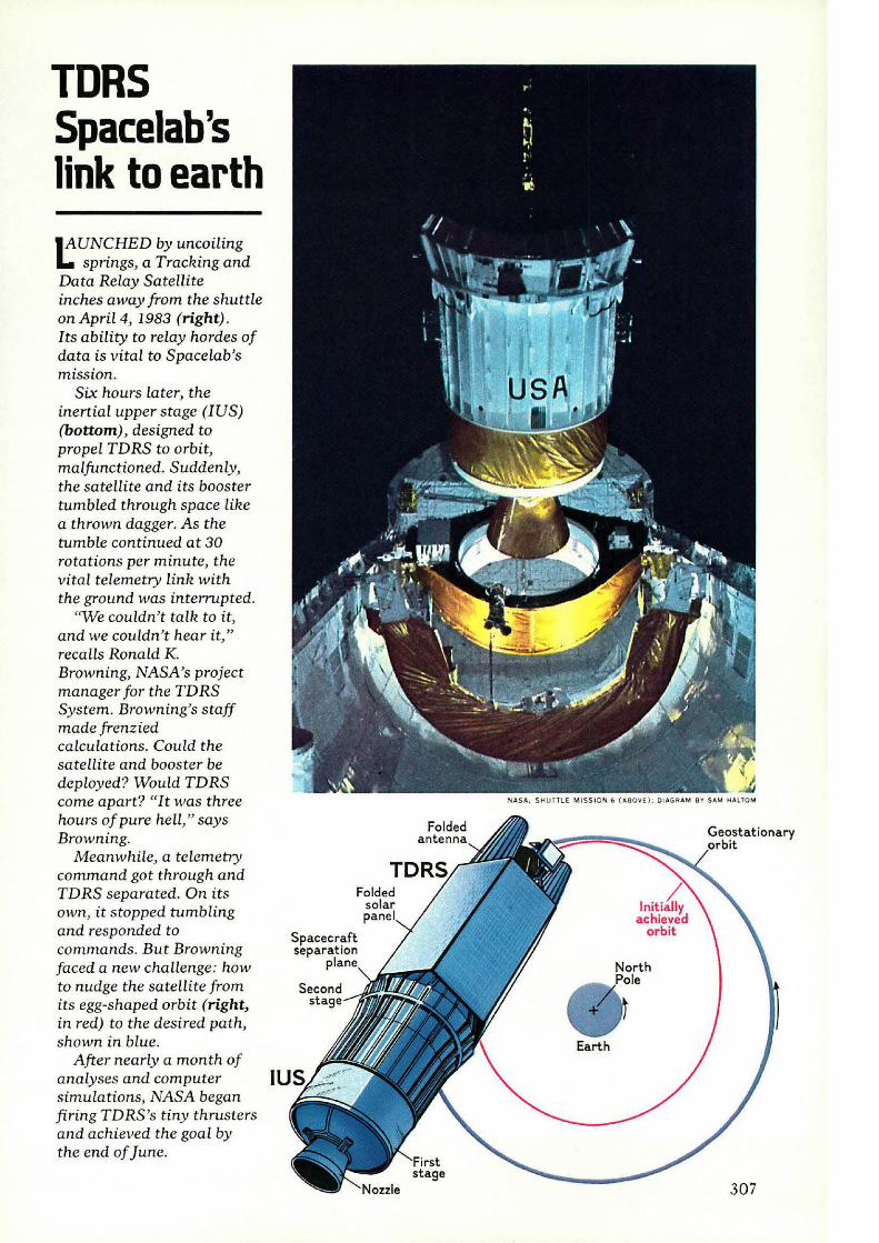
TDRS Space lab's link to earth lAUNCHED by uncoiling 1.. springs, a Tracking and Data Relay Satellite inches away from the shuttle on April4, 1983 (right). Its ability to relay hordes of data is vital to Spacelab's mission.
Six hours later, the inertial upper stage (IUS) (bottom), designed to propel TDRS to orbit, malfunctioned. Suddenly, the satellite and its booster tumbled through space like a thrown dagger. As the tumble continued at 30 rotations per minute, the vital telemetry link with the ground was interrupted.
'We couldn't talk to it, and we couldn't hear it," recalls Ronald K. Browning, NASA's project manager for the TDRS System. Browning's staff made frenzied calculations. Could the satellite and booster be deployed? Would TDRS come apart? " It was three hours of pure hell," says Browning.
Meanwhile, a telemetry command got through and TDRS separated. On its own, it stopped tumbling and responded to commands. But Browning faced a new challenge: how to nudge the satellite from its egg-shaped orbit (right, in red) to the desired path, shown in blue.
After nearly a month of analyses and computer simulations, NASA began firing TDRS 's tiny thrusters and achieved the goa l by the end of June.
Spacecraft separation
pia
NASA, SHUffLE MISSION 6 ( ABOVE); DIAGRAM 9 Y SAM HALTOM
307

(Continued f rom page 299) still was free to show me the remote-sensing laboratory he had created with assistance from the United Nations and the U . S. Agency for International Development.
"With few roads, we use a lot of bush pla nes," said Dr. Brockmann. "But poor maps were causing more than 400 crashes a year- pilots looking fo r incorrectly mapped villages and running out of gas, or slamming at night into mountains that weren't supposed to be there. Landsat permitted us to correct our maps and reduce the crashes."
Training a small staff, Dr. Brockmann harnessed Landsat for other down-to-earth tasks: to map an economical gas pipeline route across forested Bolivia, to guide engineers building a railroad through an almost impassable swamp. Analyzing imagery of an immense salt flat known as the Salar de Uyuni , he and Douglas Carter located what may be the planet's greatest concentration of lithium , vital for fusion power- perhaps the energy successor to oil.
In SantaCruz, in eastern Bolivia, I found a team of Bolivian a nd British geologists mapping an assault on the fo rbidding Huanchaca plateau , a wilderness known to few but Indian hunters. Technicians bent over Landsat images, identifying lineaments and rock outcrops that might hold minerals, looking for streams that could bear their canoes into the remote plateau. Here was an ideal use of Landsat: aiding high-technology pioneers in mapping one of earth 's most defiant frontiers.
Neighboring Brazil , I discovered , was engaged in a dynamic satellite program. "We opened our Landsat center in 197 3, and today it's the second busiest in the world , next to EROS," boasted Dr. Nelson Parada, director of IN PE, Brazil 's equivalent to NASA. "Satelli tes are the only practical way to obtain information about so enormous a country. More than 1,300 institutions use our satellite data ."
IN THE UNITED STAT ES, Landsat plays a growing role in the high-stakes search for oil and minerals. Seeking to observe the companies in their
search, illustrations editor Jon Schneeberger and I knocked at a preserve that is tightly guarded . Little wonder: We were
308
asking rival firms to reveal potential oil and ore strikes possibly worth billions of dollars.
Yet three companies- Phillips, Conoco, and Superior-admitted us to their inner sanctums. In darkened rooms crowded with the finest in electronic equipment, we saw geologists poring over satellite imagery that ranged the globe.
"When we search for oil ," explained Herbert Tiedemann of Phillips, "we look for geologic structures such as faults, folds, a nd dome-shaped formations. These can act as oil traps that concentrate deposits."
Much of this secret work still is experimental. But the eyes in space al ready have guided Chevron geologists to a major strike in Sudan's remote Sudd, a Maine-size swamp bordering the N ile.
I heard a word of caution from H . A. Kuehnert, director of exploration projects for Phillips: "Bear in mind that Landsat can only narrow the search- identify areas worth exploring further and those to be ignored. You still must go in on foot with gravimeters and costly seismic tests, and drill expensive exploration holes before you know you have something."
At Superior Oil in Houston, Stephen Nicolais described the search for minerals. "We often analyze an image for signs of iron oxide, the same reddish brown hillsides sought by the weste rn gold prospector on his donkey. Normally the coloration isn't vivid enough to show up in a regular image, so we digitally enhance color contrasts. We've already discovered indications of new copper deposits in Chile."
In his search for metal deposits, J ames R . Keighley, a jungle-wise prospector, analyzes Landsat images of remotest Brazil and Bolivia. These have led him to tin deposits worth fortunes.
"The ore often occurs in ancient streambeds and granite outcrops that are invisible even if you walk right on top of them. But Landsat images, enhanced with false colors, distinguish between vegetation growing on normal granite and on tin-bearing granite. Perhaps the metal affects the plants; anyway, that's where we find it. "
Mr. Keighley's use of Landsat to distinguish subtle vegetation differences conforms with the original intentions of the satellite's designers. They chose its sensors

Switchboard • 1n space
C'AT'S CRADLE of telemetry provides an
electronic link among satellites and earth stations and illustrates the central role ofTDRS (1) , the Tracking and Data Relay Satellite made by TRW, Inc., and launched from the shuttle last 'April.
Landsat (2) , having established its position from four satellites of the Global Positioning System (3, shown in red), directs its imaging appararus toward earth. Data collected by Landsat are beamed up to TDRS for real-time transmiss ion to an earth station at White Sands, New Mexico (4).
Without skipping a data byte, TDRS simultaneously receives transmissions from a space shuttle (5) , as well as from the Space Telescope (6) above it.
At top left, Satcom (7) , a communications satellite, relays data from White Sands to the earth station at NASA's Goddard Space Flight Center in Greenbelt, Maryland (8), lower right. PA.INTING B'r DAV IS MtLi ZER

GPS Landmarks in orbit II KE ELECTRONS L. whirring around nucleus earth (above) , the 18-satellite Global Positioning System, also known as NavStar, will provide U. S. military forces w ith position and velocity information of unprecedented accuracy.
3 10
When the full system is operational in 1988, a computer aboard a n aircraft such as a B-1 bomber (top) receives signals from four G PS satellites-A through D-orbiting 10,900 nautical miles high.
The satellites broadcast their locations as well as the exact time. The distances from the aircraft to the satellites are represented by lines a through d. These distances also equate to the time it takes for a satellite's broadcast to be received, represented by a through d on
USAf SPACE OIV IS ION
a stylized clock (above right). Almost instantly, the B- I 's
computer solves equations that determine latitude, longitude, and altitude within ten meters. It also computes the aircraft's velocity to within one-tenth of a meter per second .
Such information permits extraordinary precision in the delivery of weapons to a target whose coordinates are known. In early tests of the system utilizing four prototype satellites, attack aircraft traveling 450 knots at 10,000 feet put their bombs
National Geographic, September / 983

inside a circle about ten meters in diameter, roughly the area of a large living room. A tank (above middle) was later placed over craters made by dummy bombs at the U.S. Army proving grounds outside Yuma, Arizona, to illustrate the accuracy.
Beneath a model of the space shuttle (right) , technicians at Rockwell International's facility in Seal Beach, California, work on a G PS satellite. Of 21 satelLites to be orbited, three will serve as spares.
Satellites That Serve Us
\
' \ ' \ \
' \ 0
3 11

Search and rescue lENDING AN EAR to a pilot in L. distress (right) , receivers developed by Canada and France and installed on a U. S. weather satellite pick up emergency signals from the downed aircraft and relay them to a ground station, which pinpoints the Location.
The technique, jointly pioneered last year by the U.S.S.R. with Cospas and the U.S. with Sarsat, has saved the lives of 35 people in 15 incidents involving aircraft and ships.
With satellite relay, ship-toshore communication is as easy as picking up the phone. Cdr. T . A. Catesby (left) of the Patricia, a British Lighthouse tender, illustrates. Shore-to-ship communication is made easier by a 16-inch-wide antenna (upper left) made by Radio Research Laboratories of Koganei, japan.
~£ROY SM ITH ITOPI ; rR£0 WARD, BLACK STAR
primarily for studying growing things, as in making crop forecasts-still an uncertain art in such countries as the Soviet Union, China, and India.
Ironically, as Landsat 1 lifted from its launchpad in 197 2, buyers representing the Soviet Union were quietly calling on America's grain dealers. Unknown to U. S. officials, the U.S.S.R. wheat crop had failed disastrously, and the Russians secretly were contracting for some 20 million tonscheap. The clandestine raid persuaded the U.S. to monitor the Soviet crop annually, and satellites became one means.
The mission has posed a challenge. "One problem is the difficulty in distinguishing by satellite between grains having similar reflectances, or 'signatures,' such as wheat and barley," said Gene Rice, director of the NASA earth resources program at the Johnson Space Center in Texas.
"In addition to Landsat's measurements
312
of crop acreages, we use weather satellites to tell us if crops arc stressed by drought or winds. As acreage and moisture measurements improve, so will our forecasts."
Perfected or not, crop forecasting by Landsat was proceeding full tilt a few blocks away from the Johnson Space Center, where the U. S. Department of Agriculture was watching over the fields of major agricultural nations, including the Soviet Union. Curious about the Russians' fickle wheat crop, I entered a darkened room where analyst Pat Ashburn sat before a video image aglow with the red tones Landsat gives to healthy vegetation.
Piloting his magic console, Mr. Ashburn took me on a sweeping Landsat tour across the great Soviet wheat belt: over mammoth fields checkering Kazakhstan, the Volga River Valley (parts of it forbidden to earthbound tourists), and the Ukraine; over small fields in the Crimea and Byelorussia. In
National Geographic, September 1983
most places crops appeared normal, though the season was too young for a final forecast.
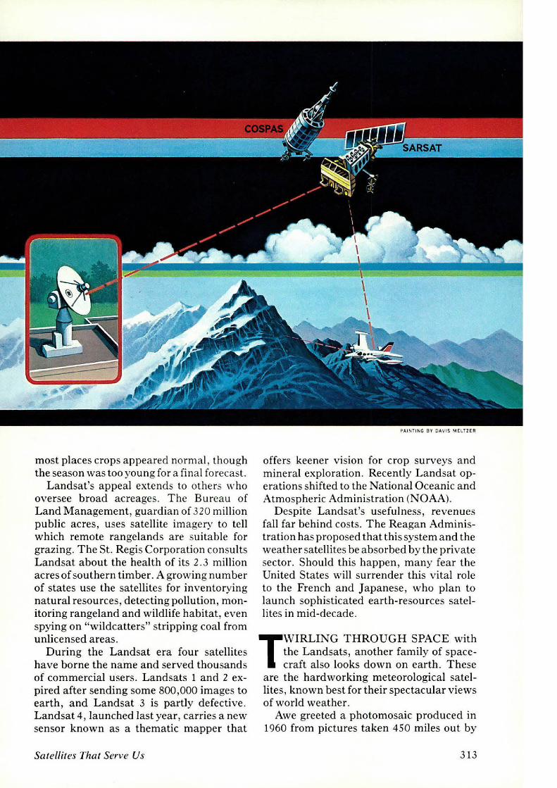
Landsat's appeal extends to others who oversee broad acreages. The Bureau of Land Management, guardian of 320 million public acres, uses satellite imagery to tell which remote rangelands are suitable for grazing. The St. Regis Corporation consults Landsat about the health of its 2.3 million acres of southern timber. A growing number of states use the satellites for inventorying natural resources, detecting pollution, monitoring rangeland and wildlife habitat, even spying on "wildcatters" stripping coal from unlicensed areas.
During the Landsat era four satellites have borne the name and served thousands of commercial users. Landsats 1 and 2 expired after sending some 800,000 images to earth, and Landsat 3 is partly defective. Landsat 4, launched last year, carries a new sensor known as a thematic mapper that
Satellites That Serve Us
PAI NTING B Y OAII IS 'IELTZER
offers keener vision for crop surveys and mineral exploration. Recently Landsat operations shifted to the National Oceanic and Atmospheric Administration (NOAA).
Despite Landsat's usefulness, revenues fall far behind costs. The Reagan Administration has proposed that this system and the weather satellites be absorbed by the private sector. Should this happen, many fear the United States will surrender this vital role to the French and Japanese, who plan to launch sophisticated earth-resources satellites in mid-decade.
TWIRLING THROUGH SPACE with the Landsats, another family of spacecraft also looks down on earth. These
are the hardworking meteorological satel-lites, known best for their spectacular views of world weather .
Awe greeted a photomosaic produced in 1960 from pictures taken 450 miles out by
313
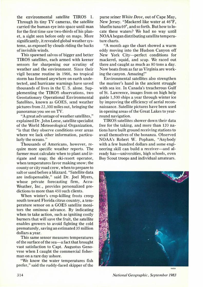
the environmental satellite TIROS 1. Through its tiny TV cameras, the satellite carried the human eye into space until man for the first time saw two-thirds of his planet, a sight seen before only on maps. More significantly, it revealed global weather systems, as exposed by clouds riding the backs of invisible winds.
This spawned salvos of bigger and better TIROS satellites, each armed with keener sensors for sharpening our scrutiny of weather and the environment. Since their vigil became routine in 1966, no tropical storm has formed anywhere on earth undetected, and hurricane warnings have saved thousands of lives in the U. S. alone. Supplementing the TIROS observations, two Geostationary Operational Environmental Satellites, known as GOES, send weather pictures from 2 2,300 miles out, bringing the panoramas you see on TV.
"A great advantage of weather satellites," explained Dr. John Leese , satellite specialist of the World Meteorological Organization, "is that they observe conditions over areas where we lack other information, particularly the oceans."
Thousands of Americans, however, require more specific weather reports. The farmer must calculate when to plant and irrigate and reap; the ski-resort operator, when temperatures favor making snow; the county or city road crew, when to prepare to salt or sand before a blizzard. "Satellite data are indispensable," said Dr. Joel Myers, whose private forecasting firm, AccuWeather, Inc., provides personalized predictions to more than 450 such clients.
When winter's crop-killing frosts creep south toward Florida citrus country, a temperature sensor on a GOES satellite monitors the ominous advance. By indicating when to take action, such as igniting costly burners that will save the fruit, the satellite enables growers to avoid fighting the cold prematurely, saving an estimated 35 million dollars a year.
This same sensor measures temperatures of the surface of the sea-a fact that brought vast satisfaction to Capt. Augustus Genovese when I caught the commercial fisherman on a rare day ashore.
"We know the water temperatures fish prefer," said the ruddy-faced skipper of the
314
purse seiner White Dove, out of Cape May, New Jersey. "Mackerel like water at 46°F, bluefin tuna 69°, and so forth. But how to locate these waters? We had no way until NOAA began distributing satellite temperature charts.
"A month ago the chart showed a warm eddy moving into the Hudson Canyon off New York City- perfect conditions for mackerel , squid, and scup. We raced out there and caught as much as 80 tons a day. Now boats from as far as Virginia are working the canyon. Amazing!"
Environmental satellites also strengthen the mariner's hand in the ancient struggle with sea ice. In Canada's treacherous Gulf of St. Lawrence, images from on high help guide 1,500 ships a year through winter ice by improving the efficiency of aerial reconnaissance. Satellite pictures have been used in opening areas of the Great Lakes to yearround navigation.
TIROS satellites shower down their data free for the taking, and more than 120 nations have built ground receiving stations to avail themselves of the bonanza. Observed NOAA's Robert W. Popham, "Anybody with a few hundred dollars and some engineering skill can build a receiver-and already has-universities, high schools, even Boy Scout troops and individual amateurs.
NASA
National Geographic, September 1983

We know of at least 800 ground stations, and there are probably thousands."
WHEN THE RUSSIANS launched Sputnik 1 in 195 7, they little sus
pected that Americans would quickly translate the satellite's radio signals into the greatest revolution in navigation since the compass.
Listening to those beeps, scientists at the Johns Hopkins University Applied Physics Laboratory in Maryland found they could use them to predict Sputnik's precise orbital position, and thus the location of the listener on earth. Other scientists at the lab thereafter developed the electronic "black box" to automate such a system, and the blessing of satellite navigation was born.
Today a constellation of five navigation satellites, launched originally to guide the Navy's Polaris submarines, serves mariners all over the world. Where an expert navigator using a sextant obtains fixes with an accuracy of one mile (and only at dawn or dusk and when it's not overcast) , a satellite navigator can tell his position within a hundred yards, night or day, clear or cloudy.
The system has won the loyalty of the tough breed who roam the seas in search of tuna, voyages that may last half a year.
"My only worry," said John Zolezzi,
New tricks with oLd imagery. A Landsat 1 image (left) shows the islands of North and South Bimini off the Florida coast, with the tip of Grand Bahama Island at top. This conventional false-coLor image, made from the green, red, and infrared bands of the satellite's scanner, gives a minimum of shoal information.
A technique devised for the Defense Mapping Agency combines the green and red bands of a similar Landsat image to produce a synthetic blue. Recombining the blue with the green and red restores true color (right), defining the extent of the shoal and revealing water depth. This will result in greatly improved nautical charts.
Satellites That Serve Us
captain of the Mary Antoinette, out of San Diego , "is that the satellite system may break down, and we'll have forgotten how to use the sextant. We use 'sat-navs' for everything: finding a fishing ground, staying on it during darkness, and simply setting a straight course from here to there-pretty important when you burn $3,500 worth of fuel a day."
To the surprise of many, the sat-nav system was greeted as enthusiastically on land as on the open sea. Perhaps as many as a thousand land surveyors now carry sat-nav black boxes along with their theodolites. "Surveys that took years now can be done in days," affirmed Richard Peat, deputy of Geodesy and Surveys for the Defense Mapping Agency.
In a few years a new generation of 18 space beacons, known as the Global Positioning System, will give fixes almost instantly within a few yards. Automakers already are testing dashboard navigators that show you where you are, and someday they could use a voice synthesizer to tell you your location and where to turn .
When the tiny Explorer 1 bore American space hopes aloft in 1958, it carried Geiger counters that revealed the existence of a powerful radiation band wrapping the earth-one of (Continued on page 326)
GEOPIC'" fROM CART H SATELLITE CORPORATION
315

3 16
A PORTFOLIO
Images of earth
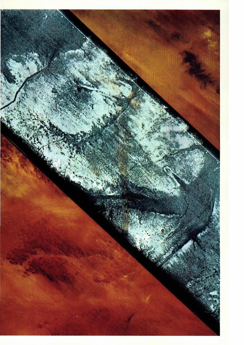
SECRETS OF THE SAHARA, hidden by sand, are revealed by the piercing eyes of
radar. A Landsat image (below) shows a vast sweep of sand punctuated by hills in northwestern Sudan. The red lines indicate the 50-kilometer-wide swath of the imaging radar carried aboard the space shuttle Columbia in November 1981.
Probing the sand to a depth of six meters (20 feet), the shuttle's radar, developed by scientists at the jet Propulsion Laboratory (]PL), literally fills in the space between the lines to reveal ancient topographical features (right).
The dark region at top has been identified as a river valley as large as that of the present-day Nile. Below it other riverbeds and valleys carve the bedrock. In a similar area in Egypt, scientists dug along a riverbed revealed by radar and discovered arrowheads 100,000 to 200,000 years old.
BOTH NASA JET PROPULSION LABORATORY

3 18
BAS-RELIEF OF TERRAIN imaged by radar in northwest Xinjiang Province, China, an area of intense tec tonic activity, shows the shearing of m ountains
along the perpendicular fault line at left . Sand, pebbles, and boulders spread out in alluvial fans from the ridges at right.
Directed at the earth at an angle from the spacecraft, radar microwaves
National Geographic, Seprember/ 983

N ASA JET PROPULSION LABORATOR Y
penetrate clouds and sand. Encountering features such as boulders, bedrock, mountains, or man-made ob}ects, the waves scatter, or bounce away like tennis balls, in various directions. Those waves that return to the spacecraft are recorded on fi lm or a ssigned numerical values that are sent back to earth via telemetry. Entered into a computer, the numbers produce an image.
Satellites That Serve Us 3 19
c
A
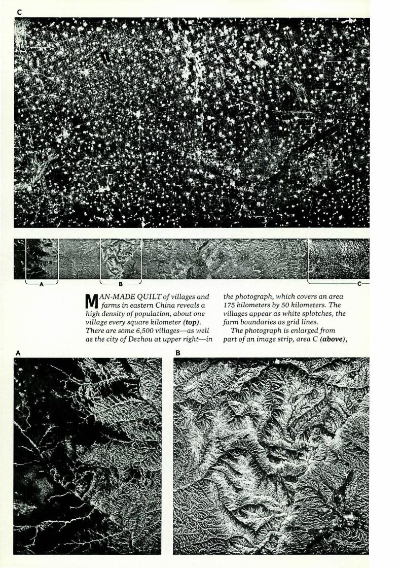
MAN-MADE QUILTofvillages and farms in eastern China reveals a
high density of population, about one village every square kilometer (top). There are some 6,500 vilLages- as well as the city of Dezhou at upper right-in
B
the photograph, which covers an area 1 75 kilometers by 50 kilometers. The villages appear as white splotches, the farm boundaries as grid lines.
The photograph is enlarged from part of an image strip, area C (above),

made by the shuttle's radar in a sweep from the Great Wall to the Yellow Sea.
An enlargement (below, middle) of area B shows drainage patterns radiating from the Luya Mountains in Shanxi Province. The mountain peaks are heavily forested and show as bright areas.
The mountains meet the Mu Us Desert (bottom left) in an enlargement of area A.
Principal investigator of the team that created the shuttle's radar, Dr. Charles Elachi (right) examines strips of the imagery at]PL. "We knew in theory that radar could penetrate sand," he says, "but this i.s the first time it has been verified on a large scale."
From archaeology to geologic mapping, Dr. Elachi sees a bright future for the new imaging process. On a shuttle mission next year, the radar· will image Egypt's entire W estern Desert. NASA plans to put the radar on a spacecraft bound for Venus in 1988 to create the first map of that cloudcovered planet.
From the Great Wall to the Yellow Sea, the 50-kilometer-wide track of the shuttle's imaging radar traverses deserts, mountains, and agricultural areas.
32 1

rR tO WARD lABOV E>: NASA/ (ARl H RESOURCES INSTITUTE o r MICHIGAN
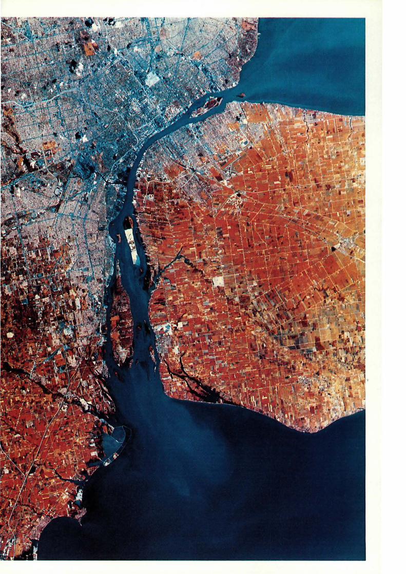
SPACE-BORNE MAPPERS, Landsat 4's imaging systems
provide a picture of Detroit, Michigan, and environs (right) from a n altitude of 440 miles.
To make this photograph, three of the satellite's seven imaging systems were employed- red and green in the visible-light wavelengths and the near infrared.
Detroit, at upper center, and Windsor, Ontario, are separated by the Detroit River. At left center, Highway 94 skirts the runways of Metropolitan Wayne County Airport and, farther west, threads between Lake BelLeville and the runways that appear as spokes in the Willow Run Airport.
Dr. Alden Colvocoresses (above), research cartographer at the U. S . Geological Survey in Reston, Virginia, holds the Dyersburg, Tennessee, image map, the first quadrangle made from Landsat's thematic mapper data. "Now," he says, ((it is up to the map users to tell us how useful they find this kind of map."
322


made by the shuttle's radar in a sweep from the Great Wall to the Yellow Sea.
An enlargement (below, middle) of area B shows drainage patterns radiating from the Luya Mountains in Shanxi Province. The mountain peaks are heavily forested and show as bright areas.
The mountains meet the Mu Us Desert (bottom left) in an enlargement of area A.
Principal investigator of the team that created the shuttle's radar, Dr. Charles Elachi (right) examines strips of the imagery at]PL. "We knew in theory that radar could penetrate sand," he says, "but this i.s the first time it has been verified on a large scale."
From archaeology to geologic mapping, Dr. Elachi sees a bright future for the new imaging process. On a shuttle mission next year, the radar· will image Egypt's entire W estern Desert. NASA plans to put the radar on a spacecraft bound for Venus in 1988 to create the first map of that cloudcovered planet.
From the Great Wall to the Yellow Sea, the 50-kilometer-wide track of the shuttle's imaging radar traverses deserts, mountains, and agricultural areas.
32 1
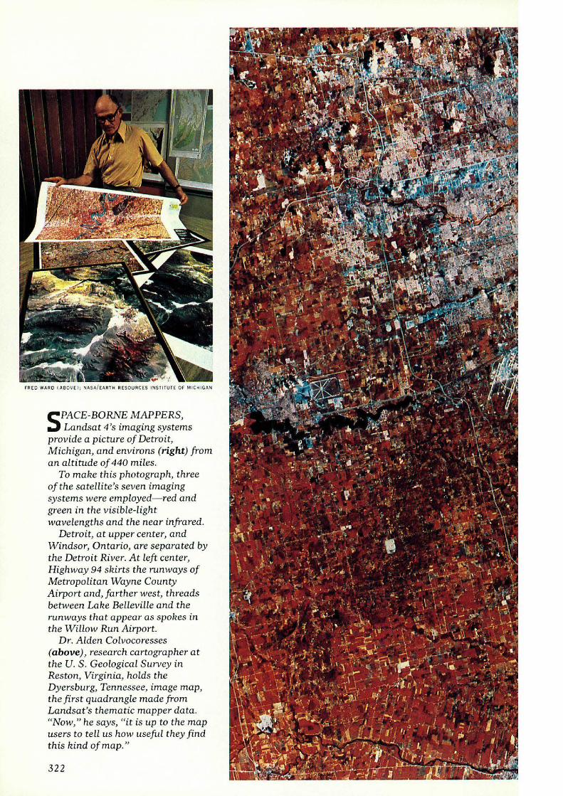
rR tO WARD lABOV E>: NASA/ (ARl H RESOURCES INSTITUTE o r MICHIGAN
SPACE-BORNE MAPPERS, Landsat 4's imaging systems
provide a picture of Detroit, Michigan, and environs (right) from a n altitude of 440 miles.
To make this photograph, three of the satellite's seven imaging systems were employed- red and green in the visible-light wavelengths and the near infrared.
Detroit, at upper center, and Windsor, Ontario, are separated by the Detroit River. At left center, Highway 94 skirts the runways of Metropolitan Wayne County Airport and, farther west, threads between Lake BelLeville and the runways that appear as spokes in the Willow Run Airport.
Dr. Alden Colvocoresses (above), research cartographer at the U. S . Geological Survey in Reston, Virginia, holds the Dyersburg, Tennessee, image map, the first quadrangle made from Landsat's thematic mapper data. "Now," he says, ((it is up to the map users to tell us how useful they find this kind of map."
322

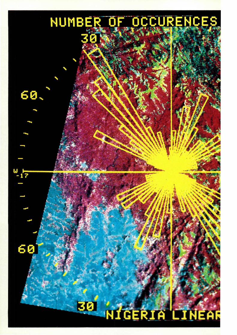
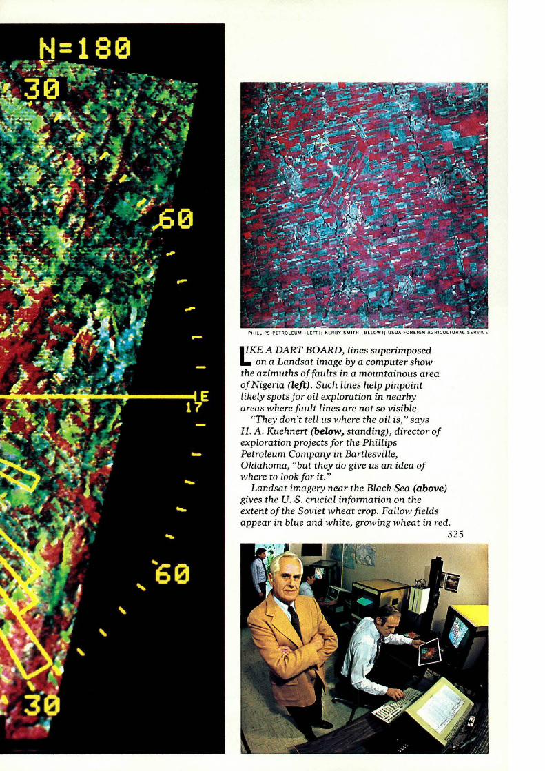
PHILLI PS PET ROLEU M ILEn l : KCRBY SMITH I BELOW); USDA fOREIGN AGRICU LTURAL SERVIC£
liKE A DART BOARD, lines superimposed 1.. on a Landsat image by a computer show the azimuths of faults in a mountainous area of Nigeria (left). Such lines help pinpoint likely spots fo r oil exploration in nearby areas where fault lines are not so visible.
"They don 't tell us where the oil is," says H. A. Kuehnert (below, standing), director of exploration projects for the Phillips Petroleum Company in Bartlesville, Oklahoma, "but they do give us an idea of where to look for it."
Landsat imagery near the Black Sea (above) gives the U. S . crucial information on the extent of the Soviet wheat crop. Fallow fields appear in blue and white, growing wheat in red .
325

(Continued/rom page 315) the famed Van Allen belts. Since then , at least a quarter of all satellites have been dedicated to science programs, coordinated largely by NASA, the Soviet Union, and the European Space Agency.
Training their sensors on earth's surface, they have mapped its varying magnetic contours, measured the drift of the continents, and showed that the "level" sea actually undulates with great troughs and ridges varying 600 feet in elevation. Studying the atmosphere, they record fluctuations of its ozone content. Carrying astronomers' eyes beyond earth's obscuring atmosphere, they have opened dramatic windows onto the universe, including the discovery of X-ray sources that may indicate the locations of black holes.
SCANNING their green-tinted scopes in March of 1981, radar operators at NORAD detected the ascent of Soviet
Cosmos satellite number 1258. Interest quickened as the spacecraft gained on another Soviet satellite, Cosmos 124 1.
Two orbits after launch, radar showed Cosmos 1258 closing on its quarry. The rest is classified, but in a likely scenario, the pursuer suddenly vanished-exploded by a signal sent up by Russians on the ground. Its shrapnel smashed into Cosmos 124 1. It was the 19th known test of a Soviet hunter-killer satellite, and the ninth simulated kill .
Lt. Gen. Kelly Burke, then chief of research for the U. S. Air Force, told me of U. S. efforts to develop a counterforce. "Soon we'll be demonstrating an antisatellite missile fired from a fighter plane, and it will be better than the Soviet system," said General Burke. "In most areas of space," he added, "we have a clear technological lead."
Will satellites someday become chariots of war, hurling the thunderbolts of lasers and particle beams at cringing earthlings?
International treaties, always fragile, prohibit deployment of weapons of mass destruction in space. But some authorities believe the Soviet Union is developing a satellite-borne lase r system that by middecade could be capable of destroying U. S. satellites or missiles. The Department of Defense contends that the Soviet laser program is three to five times as large as that of the
326
U. S. Other experts, however, believe that a parallel U. S. program would be disastrously expensive, if not also unfeasible.
"Satellites are ill suited for the role of destruction," said Dr. Harris Mayer, a space and defense scientist. "Equipping them for the massive terrestrial bombardments of Star Wars would require orbiting prohibitive amounts of energy and mass. Communications surveillance and navigationthese will be the military tasks of satellites."
In Dr. Mayer's view of space and war: • Swarms of simple, low-flying communication satellites-too many to knock outmaintain vital command links. • Powerful navigation satellites, beaming down directional signals through any weather, guide tanks, ships, aircraft, missiles-even foot soldiers wearing tiny wrist receivers. • Denying the enemy the cover of darkness, space lasers bathe the night battlefield with light invisible to the enemy's unaided eye, but bright as moonlight to friendly forces equipped with special eyeglasses. • N uclear-powered satellites emit electric impulses that jam electronic systems, such as those that controlled Argentine air-tosurface missiles that sank a British destroyer during the Falkland Islands conflict.
The satellites, meanwhile, will not be sitting ducks. "Those in geostationary orbit, which include most military spacecraft , are relatively invulnerable," said Lt. Gen. Richard C . Henry (Ret.), former commander of the Air Force Space Division.
" If an A-sat [antisatellite] approaches, we can command a satellite to evade by moving it miles away, then move it back. Satellite circuitry is hardened against the radiation of nuclear explosion, known as an electromagnetic pulse . We provide elaborate defenses against frequency jamming and against tricking a satellite with false commands. And for many military satellites in orbit there's a spare parked nearby, ready to be brought on-line when needed.
"A revolution in missile delivery will come with the new Global Positioning System, " continued General Henry. "Guided by these navigational satellites, missiles t raveling thousands of miles will be able to pinpoint their targets within hundreds of feet."
National Geographic, September 1983
Unlike satellite weaponry, spy satellites enjoy international protection. U.S.Soviet treaties, politely calling the spacecraft "national technical means," permit them for monitoring arms-limitations compliance . They also guard against surprise attack or warn of military buildup in trouble spots around the globe.
Spy satellites possess awesome acuteness of vision. Some watch for the fiery trail of missile launches and the unique blasts of nuclear tests. Lower orbiters record scenes on film that is later released by parachute and snagged in midair by Air Force planes. While the camera resolutions are highly classified, nonofficial accounts say they can reveal Soviet license-plate numbers, and even distinguish uniformed personnel from civilians.
Secrecy shrouds most Soviet space operations. But free-world experts know much of that nation's immense space effort, partly because of the ingenious electronic snooping of Geoffrey Perry, a graying physics teacher at the Kettering Boys School outside London, and founder of the Kettering Group of amateur space observers.
"It's relatively simple to detect Soviet launches," explained Mr. Perry, pointing to a rudimentary school-top antenna. "Eavesdropping on their radio frequencies, my students and I simply wait to hear the chirpings of a newly hatched satellite. If the Russians encode its telemetry signals, we try, often successfully, to break the code."
WHAT DOES THE future hold for satellites?
"The technology of satellites is advancing faster than any other," said Abraham Schnapf, RCA's veteran manager of satellite development. "Nowhere is this more evident than in communications. Higher frequency transmissions will permit more satellites to park in the geostationary belt; higher transmission speeds will dramatically multiply each spacecraft's effectiveness.
"Electronic mail by satellite is already becoming a reality. In 15 years satellites will relay alarms of house break-ins to your local police station- and disaster warnings to your wrist radio. And someday shopping services, library books, and perhaps the
Satellites That Serve Us
BOT~ BY 0 . LOU IS MAZZAT ENTA, NATIONAL GEOGRAPHIC STAFF
Eavesdropping, a student at Kettering Boys School north of London tunes in on a broadcast from a Soviet weather satellite (above). His 1938 receiver is the kind that was used by the British in World War II to find the frequency of the radio beams directing German bombers to British cities.
Thus Geoffrey Perry, MBE (below), head of physics, introduces his students to the art of satellite tracking. "It's all detective work," says Perry, who has logged more than 14,000 satellite passes, ((and it's good experience for the boys." In 1966 the space detective revealed to the world that the Russians were using a new launch site.
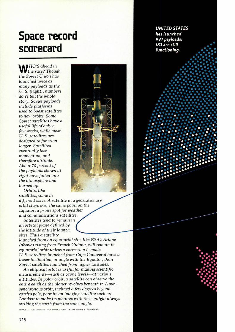
Space record scorecard
WHO'S ahead in the race? Though
the Soviet Union has Launched twice as many payloads as the U.S. (right) , numbers don't tell the whole story. Soviet payloads include platforms used to boost satellites to new orbits. Some Soviet satelLites have a useful life of only a few weeks, while most U. S. satellites are designed to function Longer. Satellites eventually Lose momentum, and therefore altitude. About 70 percent of the payloads shown at right have fallen into the atmosphere and burned up.
Orbits, like satellites, come in different sizes. A satellite in a geos tationary orbit stays over the same point on the Equator, a prime spot for weather and communications satellites.
Satellites tend to remain in an orbital plane defined by the latitude of their launch sites. Thus a sate lli te launched from an equatorial site, like ESA's Ariane (above) rising from French Gui.ana, will remain in equatorial orbit unless a correction is made. U.S. satellites Launched from Cape Canaveral have a lesser inclination, or angle with the Equator, than Soviet satelLites launched from higher latitudes.
An elliptical orbit is useful for making scientific measurements-such as ozone levels- at various altitudes. In polar orbit, a satellite can observe the entire earth as the planet revolves beneath it. A sunsynchronous orbit, inclined a few degrees beyond earth's pole, permits an imaging satellite such as Landsat to make its pictures with the sunlight always so·iking the earth from the same angle. JAM ES l . LONG ASSOCIATES f AC.OVE): PAINTING BY LLOYD K. TOWtl SEN O
328
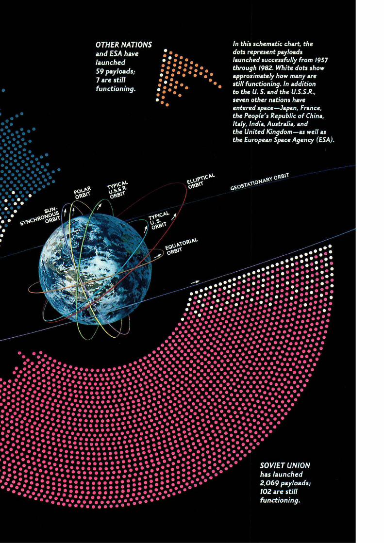

NATIONAL GEOGRAPHIC will arrive via satellite to your home TV. "
NASA foresees major benefits from environmental satellites.
"They're invaluable to understanding the complete envelope of the environment-the complex interactions of the oceans, atmosphere, and polar regions, " said Dr. David Atlas , chief of NASA's Laboratory for Atmospheric Sciences. "Only satellites can map the annual waxing and waning of the polar ice sheets , which have an immense effect on the atmosphere."
Satellites also will aid in "now-casting"pinpointing locations of severe storms such as tornadoes before they strike.
NASA's Dr. A. Fritz Hasler, who developed one promising technique, handed me a composite image made from two satellites simultaneously. Peering through special stereoscopic glasses, I saw an ugly curd of clouds. "We call that a 'pig nose,'" said Dr. Hasler. "It's the top of the severe thunderstorm containing the tornado that blasted Wichita Falls, Texas, in 1979, destroying 4,000 homes. Stereo surveillance can help detect these in time to give warning."
Science in space will soar to a new plateau in 1986, when the shuttle hauls aloft a 12-ton orbiting observatory known as the Space Telescope. Big as a boxcar, it will expand man's vision in the heavens sevenfold, possibly to the very edges of the known universe.
Ironically, the technological revolution soon will spell doom fo r today's familiar , free-flying satellites. "They're too costly to
To attack ...
KILLING A SATELLITE, U.S. style. In a system now being tested, an
F -15 fighter fires a two-stage m issile at its target. With telescopes for eyes, the 50-pound warhead adjusts its fl.ight path for intercept.
Soviet style: a much heavier satellite, known as a hunter-killer, is boosted to the same orbital path as its target, closes in, and explodes. Using their own satellites as targets, the Russians have demonstrated this capability many times.

keep throwing away," said Ivan Bekey, NASA's director of Advanced Programs and Plans, "and too numerous to be serviced by the shuttle. Within two decades they'll be largely obsolete, little dinosaurs in space.
"In their place," he continued, "shuttle crews will assemble large platforms, each clustering many payloads powered by a central utility module. Some will point sensors toward the sun and stars, others will peer down at weather and earth's resources , and still others will provide automated laboratories for making pharmaceuticals, alloys, semiconductors , and other high-value materials best processed in zero gravity."
By 1991, if NASA's plans materialize, these platforms will be joined by a permanent manned space station. One of its prime missions will be to serve as a stepping-stone for massive , economical exploitation of the coveted geostationary zone.
"That's the high ground of space," explained Earl Cole of the space station program at Rockwell International Corporation, one of the eight aerospace firms under NASA contract to help plan missions for the next-generation space system. "The nation that develops the most efficient technology for moving mass into geostationary orbit will dominate space."
In most of the mission designs, modules destined for a geostationary berth ride the shuttle to the manned station, where they park for an electronic health check and deployment of their fragile antennas. Then the station crew loads the module aboard an
... to defend
FRUSTRATING an attack on its satellite fleet, the U. S. employs
several options. Telemetry signals are encryp ted and m ade jam-resistant by varying frequencies and other m ethods. The satellite's circuitry is hardened against radiation from nuclear blasts.
Using its thrusters, the satellite maneuvers evasively to another orbit, thus presenting its assailant with a new task. If a satellite is hit, a spare can take its place. Covert spares in deep space are also ready for duty. PAI NT INGS BY OAVIS MELTZ ER
33 1

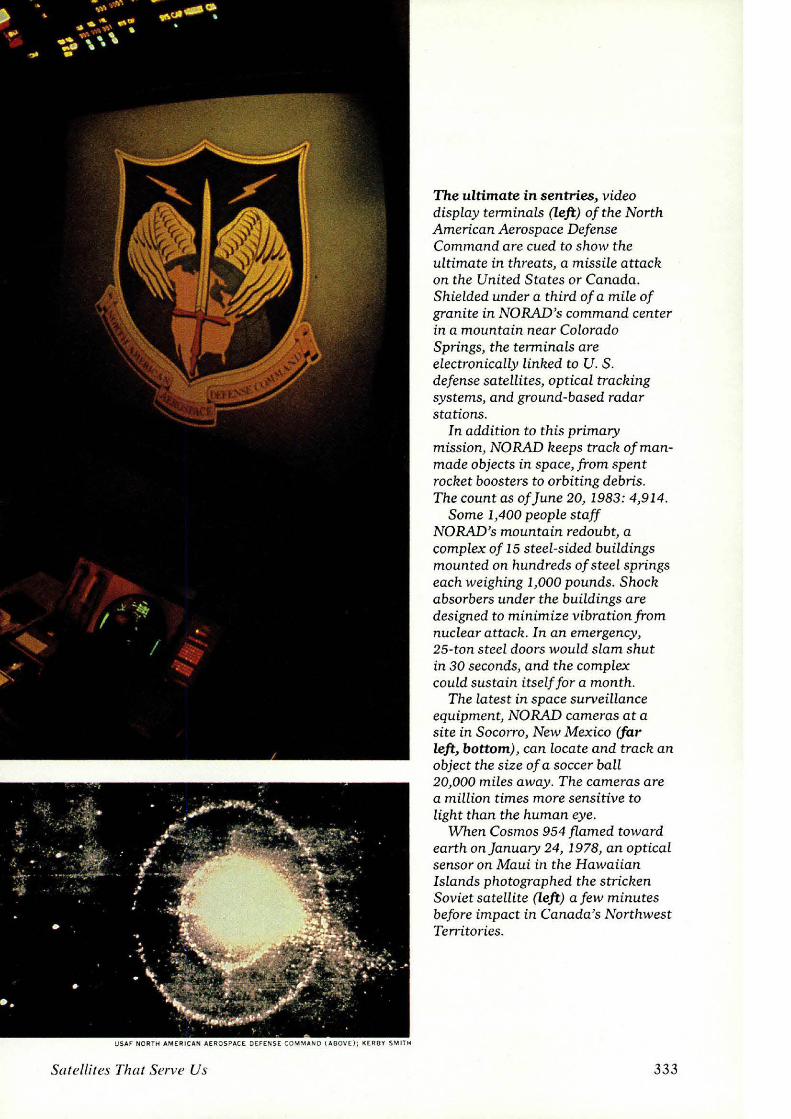
USAF NORTH AMERICAN AEROSPACE DEFENSE C0 \1 \1AN O lABOVE); KERBY SMITH
Satellites That Serve Us
The ultimate in sentries, video display terminals (left) of the North American Aerospace Defense Command are cued to show the ultimate in threats, a missile attack on the United States or Canada. Shielded under a third of a mile of granite in NORAD's command center in a mountain near Colorado Springs, the terminals are electronically linked to U. S. defense satellites, optical tracking systems, and ground-based radar stations.
In addition to this primary mission, NORAD keeps track of manmade objects in space, from spent rocket boosters to orbiting debris. The count as of june 20, 1983: 4,914.
Some 1,400 people staff NORAD's mountain redoubt, a complex of 15 steel-sided buildings mounted on hundreds of steel springs each weighing 1,000 pounds. Shock absorbers under the buildings are designed to minimize vibration from nuclear attack. In an emergency, 25-ton steel doors would slam shut in 30 seconds, and the complex could sustain itself for a month.
The latest in space surveillance equipment, NORAD cameras at a site in Socorro, New Mexico (far left, bottom), can locate and track an object the size of a soccer ball 20,000 miles away. The cameras are a million times more sensitive to light than the human eye.
When Cosmos 954 flamed toward earth on january 24, 1978, an optical sensor on Maui in the Hawaiian Islands photographed the stricken Soviet satellite (left) a few minutes before impact in Canada's Northwest Territories.
333

unmanned orbital transfer vehicle (OTV) for relay to a platform abuilding in the geostationary belt. Automatically plugging the module into the platform, the OTV returns to the manned station to be reused, eliminating virtually all of the 30-million-dollar cost of using expendable rockets to boost satellites into higher orbit.
This rush to the geostationary zone comes as no surprise to its farsighted advocate. "Someday," mused Arthur Clarke over coffee and croissants during a United Nations space conference in Vienna, "the zone will be a solid ring of structures, housing thousands of devices to serve mankind. There will be enough radio capacity up there for the whole human race to pair off and talk with itself. As the Russian engineer Yuri Artsutanov prophesied, someday we may ascend to the ring by elevator, riding cables reaching like an Indian rope trick 22,300 miles high."
The scramble to share in the great space rush is reflected in the budding competition to provide launch facilities. The European Space Agency, vying with the space shuttle, has signed up several U. S. satellites to ride its rocket , the Ariane. Several private U. S. corporations, using off-the-shelf rocket components, hope to be able to launch commercial satellites for much less than NASA charges.
There's room for all. Delays in the shuttle and early failures of Ariane have generated a waiting line of satellites that have purchased tickets to space but have seen their flights postponed.
The multi-ring satellite circus is only beginning, and it's a spectacle we on earth can observe. On a clear evening, when darkness settles about your home , go outdoors and peer into the sky. In a few minutes you'll probably notice that one of those tiny golden "stars" is slowly moving. It will be an obedient electronic servant in space, orbiting on high to improve the lives of all of us. 0
334
Earth wears a halo in this remarkable image of the aurora borealis, the northern lights, made by an ultraviolet camera aboard Dynamics Ex plorer 1. The bright crescent is a portion of the sunlit s ide of the planet.
HA.SA/L. A. FRANK, UNIVERSITY OF' I OWA
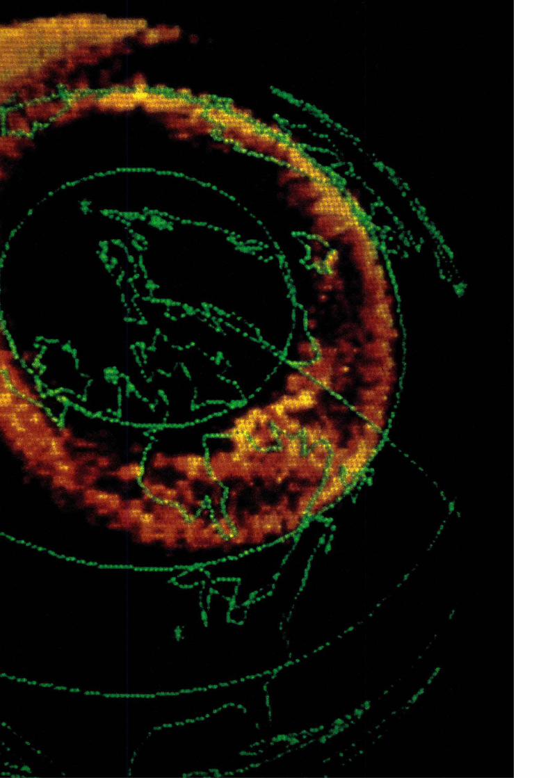

ALASKA'S FAR-OUT ISLANDS
e eutians By LAEL MORGAN
Photographs by STEVEN C. WILSON I:~HI EOS
H E SPLENDID wilderness of volcanic peaks ahead was represented on an Alaskan map as an "unknown area," and seas that separated us from the island of Attu were veiled in a rich lace of spindrift.
"Isn't it magnificent?" I yelled over the roar of the old Electra prop plane to the Coast Guard novice who had been my seatmate on the six-hour flight from Anchorage.
"The guys tell me this is America's Siberia," he observed dubiously.
Our destination was the 24-man loran station on the westernmost of the Aleutian Islands-the most remote bits ofland in the United States, the farthest west extension of the North American Continent and the farthest east , too, because in mid-sweep the archipelago crosses 180° into east longitude (map , pages 340-41).
"It's not the end of the world, but you can see it from here," quipped an old hand across the aisle. "Still , if you like extremes .. . lousy weather, tid-al waves, earthquakes . . . . "
I understood these reservations, and yet this graceful island arc, wedged between the fearsome North Pacific and the storm-wracked Bering Sea, is to me the most fascinating place on earth. A stepping-stone chain between continents and the longest network of active volcanoes m North America, the Aleutians are so little
336
Stirring a tempest in a lonely outpost, raucous seabirds nes t each summer on the kelp-rich shore of Unalga Island in the Aleutian archipelago. A glaucous-wing gull, startled from its nes t, overflies a cormorant guarding its young.

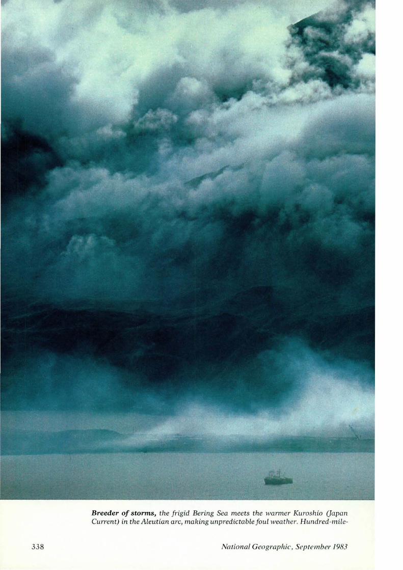
338
Breeder of storms, the frigid Bering Sea meets the wanner Ku rosh io (Japan Current) in the Aleutian arc, making unpredictable fou l weather. Hundred-mile-
National Geographic , September 1983

an-hour wilLiwaws blast treeless slopes with horizontal rain and snow. Fog, here r·oiling over Unalaska, can become so thick that fishermen can't see their boots.
The Aleutians 339
known that whole mountain ranges go unnamed and unexplored. Seabirds-puffins, murres, fulmars, kittiwakes, cormorants, and many other species-mass in these islands by the hundreds of millions. Bald eagles are more common than ravens.
Valuable fur seals and great whales favor island passes on their annual migrations. Perhaps the world's largest concentration of marine mammals is found here: vast colonies of sea lions, seals, and sea otters. Plankton , tiny marine plants and animals that are the basis of the ocean's food chain, thrive in record numbers. More than a million metric tons of pollack, sole, cod, halibut, and salmon are caught in the Bering Sea annually, as well as an enormous tonnage of shellfish.
FOR MORE THAN A DECADE I have traveled this area as a journalist in the company of Aleut subsistence hunters, remnants of a people that once lived
throughout the archipelago but who now occupy only five of its 124 islands. The amenities of civilization are often hard to come by here , but there is a compensating closeness between families and with nature.
In 1913 most of the chain was declared a wildlife refuge, banning the sea harvest
that had left some mammals near extinction. The U. S. Fish and Wildlife Service controls
access to most of the islands, largely property of the federal government.
17s•
Attii~ttu Island COAST GUARD L AN STATION
NEAR ISLANDS ' •fSHEMY AIR FORCE STATION
Sailors warn that the Aleutians have the world's worst weather, and most visitors, exiled to remote military outposts, are justified in their tales of bitter hardship.
"These islands are one of the most beautiful spots in the world ," said James Bush , a World War II veteran of Attu, where weather caused more casualties than enemy fire . "But you must forgive me if I also see them as death. I think oft he young kids, like these running the Coast Guard station today .. . who never got to come home. "
American casualties in the 1943 Battle of Attu exceeded 3,500, some 2,100 by exposure . In 1981 the Veterans of Foreign Wars asked that Congress give national recognition to their sacrifices. Still the ground remained unmarked , save for memorials left by families of Japanese who died there. I had asked Jim Bush, who played a major role in that conflict, to return with me to Attu (page 342}.
The author draws on long familiarity with the Aleuts for her portraits of the isles and people (March 1973 and October 1974 GEOGRAPHies). Wildlife and wild places are a specialty of photographer Steve Wilson (February 1981).
Ocean
1"' Shemya I.
Agattu I. During World War II, Japanese troops occupied Attu and Kiska but made no
further moves toward the U.S. mainland.
180°
1ao• o/AST WEST
GRE NWICH
Be . r' n 9
Kiska !·~ ~ . S e a
~ • • 4!. Sem1so ADAK R .:a. NAVAL
A T '- ""' STATION I S L A N D S Tanaga I. J
Amchit a Island (I "-Jr• ;If. '!~~ · • ..,vt ~~ Delaroi Kanag I. ,. 1 1 d · Adak Island Despite widespread protests,
Amchitka was used as the u'"ilcle"!!!ound test site for nud ar dmces-in~969, and 19 .
,) san s AND REANOF
Pacific


