Sauk County Comprehensive Outdoor Recreation Plan 2014 ‐ 2019 Sauk County Parks Department 02/06/2014 Every five years the Comprehensive Outdoor Recreation Plan or CORP is updated and reviewed. As a component of this plan, a stakeholder group was assembled by the Highway and Parks Committee of the Sauk County Board of Supervisors to update the existing CORP. The public is then asked to review the updated CORP. The document will then be adopted at the March meeting of the Sauk County Board of Supervisors.
Transcript
SaukCountyComprehensiveOutdoor
RecreationPlan2014‐2019
Sauk County Parks Department
02/06/2014
Every five years the Comprehensive Outdoor Recreation Plan or CORP is updated and reviewed. As a component of this plan, a stakeholder group was assembled by the Highway and Parks Committee of the Sauk County Board of Supervisors to update the existing CORP. The public is then asked to review the updated CORP. The document will then be adopted at the March meeting of the Sauk County Board of Supervisors.
2013 Sauk County Comprehensive Outdoor Recreation Plan
1.0 Introduction Parks and Open Spaces Well-managed parks and open spaces provide immeasurable benefits. They offer a variety of recreation opportunities that promote physical, social and emotional well-being. Parks and open spaces afford relief from urban stresses while providing areas for habitat protection and enhancement. In Sauk County, outdoor recreation is a major source of tourism income. Parks and open spaces have been, and continue to be part of our National, State and local heritage. Purpose of Plan The purpose of Sauk County’s Comprehensive Outdoor Recreation Plan (CORP) is to identify strengths and needs of Sauk County’s parks, related facilities and outdoor recreation opportunities. Sauk County’s CORP is further intended to maintain County eligibility to apply for and receive grants and aid money. The CORP analysis is the foundation for acquisition and development of outdoor parks and recreational facilities that are to be designated for public use. The Sauk County CORP can be more than just a useful tool for the Sauk County Parks and Recreation Department as well as other municipalities. It offers a vision for the future, sets the course for the recreational future our grandchildren will inherit, and identifies the means to achieve these objectives. Sauk County’s Park and Recreation Department Mission “It is the mission of the Sauk County Parks and Recreation Department to acquire, develop, protect and maintain our parks and facilities for all citizens and to provide outdoor recreational opportunities that contribute to the well being of individuals and families.” Overview of the Plan and the Planning Process The most recent CORP was completed in 2008. This 2013 Plan includes a review of 2008 CORP to monitor progress (See Section 2.3). The Wisconsin Statewide Outdoor Recreation Plan (SCORP), the Wisconsin Land Legacy Report and other pertinent planning processes and plans will be recognized and incorporated. An update of the natural and cultural resources, parks and recreation inventories and analysis of municipal, county, state and federal lands follows. Goals, objectives and policies have been developed based on the inventory and analysis, and the public participation process. Local public input came from a meeting of a Recreational Stakeholder Advisory Committee appointed by the Sauk County Highway and Parks Committee, the Sauk County Board of Supervisors oversight committee for the Parks and Recreation Department. The Advisory Committee, comprised of citizens from throughout the county who represent a wide variety outdoor recreation interests. They reviewed the goals and policies of the previous CORP to refine issues and oversee the development of the Plan document.
Adopted by the Sauk County Board of Supervisors November 11, 2008 1
2013 Sauk County Comprehensive Outdoor Recreation Plan
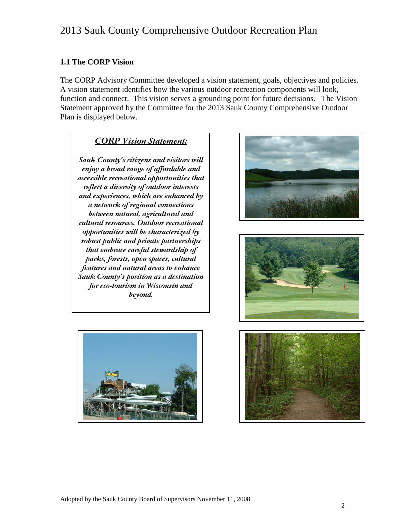
1.1 The CORP Vision The CORP Advisory Committee developed a vision statement, goals, objectives and policies. A vision statement identifies how the various outdoor recreation components will look, function and connect. This vision serves a grounding point for future decisions. The Vision Statement approved by the Committee for the 2013 Sauk County Comprehensive Outdoor Plan is displayed below.
CORP Vision Statement: Sauk County’s citizens and visitors will enjoy a broad range of affordable and
accessible recreational opportunities that reflect a diversity of outdoor interests
and experiences, which are enhanced by a network of regional connections between natural, agricultural and
cultural resources. Outdoor recreational opportunities will be characterized by robust public and private partnerships
that embrace careful stewardship of parks, forests, open spaces, cultural
features and natural areas to enhance Sauk County’s position as a destination
for eco-tourism in Wisconsin and beyond.
Adopted by the Sauk County Board of Supervisors November 11, 2008 2
2013 Sauk County Comprehensive Outdoor Recreation Plan
1.2 Goals, Objectives and Policies Using the vision statement, resource inventories and the public survey responses, the Advisory Committee developed a set of Goals, Objectives, and Policies. Goals are broad, advisory statements that express general public priorities about how the County should approach the development, maintenance and preservation of outdoor recreation opportunities and facilities. Goals are based on key issues and opportunities. The Committee identified the following preliminary goal statements early in the planning process:
PRELIMINARY GOAL STATEMENTS
1. View public land as an asset 2. Develop support for increased funding 3. Identify needs & promote acquisition of additional park space 4. Promote partnerships for funding, development and management 5. Identify use trends and provide facilities as needed 6. Actively promote educational programs and seminars to enhance/cultivate awareness
and enjoyment 7. Encourage use of “Green Building”, low impact development 8. Promote Natural Resources stewardship 9. Inform public about their role in preserving/protecting Natural and Recreational
resources 10. Less trash in parks 11. More recreational opportunities 12. Quality recreational resources 13. Connectivity 14. Expanded use of Baraboo and Wisconsin Rivers 15. Reach critical mass of green business 16. Quantify economic impact of natural resources and recreation
Through its subsequent meetings, the Committee refined these statements into a more manageable set of Goals, each prefaced by a Finding of current conditions and supported by specific Objectives and Policy Recommendations, both for the Parks Department operations in general and for the specific County parks and recreation properties. The Committee defined the term “Objectives” as referring to future directions that are more specific than goals. Objectives should be measurable, but that is sometimes not easy to do. However, objectives are intended to be attainable through policies and implementation activities. Finally, “Policies” are defined as the rules, courses of action or programs used to ensure Plan implementation and to accomplish the Goals and Objectives. The complete breakdown of Goals, Objectives and Policies for the 2013 County Outdoor Recreation Plan are described in the following pages.
Adopted by the Sauk County Board of Supervisors November 11, 2008 3
2013 Sauk County Comprehensive Outdoor Recreation Plan
1.2.1 Parks and Recreation Program Goals, Objectives and Recommendations Goal #1: Preserve and enhance the recreational lands and facilities that we currently have and continue to expand outdoor recreational resources available for citizens and visitors as both populations continue to grow. Finding: Sauk County currently enjoys an array of high quality recreational resources and facilities. Normal wear and tear will take their toll on these properties even under current use levels. Sauk County’s population is expected to increase over the next twenty years, as is the number of visitors to Sauk County. Demand for additional types of recreational opportunities reflects evolving demographic and societal trends as populations age and recreational interests change. These factors will significantly intensify the pressures on existing facilities, and create demand for new ones.
Objectives:
1. Ensure that outdoor recreational opportunities are accessible and affordable for people of all financial means and physical abilities.
2. Incorporate diversity into park activities and become adaptable to new recreational trends. 3. Enhance inter-connectivity of parks, open spaces and trails throughout Sauk County, with special emphasis on linking major recreational properties such as the 400 Trail, the Ice Age Trail, State and County Parks and public lands, the Badger Army Ammunition Plant, the Upper and Lower Wisconsin River corridor and the Baraboo River corridor. 4. Support the development of existing and new public and private facilities that contribute to and enhance the public recreational resources available in Sauk County. 5. View public lands and their current and potential uses as an asset to Sauk County.
Recommendations:
1. Utilize this CORP assessment of needs and uses of parks and open space facilities and other county-owned lands to address identify unmet location needs, develop new recreational use opportunities and effectively coordinate their creation.
2. Work collaboratively with other partners to plan for and improve recreational opportunities, such as trail connections, using local comprehensive plans and the County comprehensive plan.
3. When zoning/development applications are made for the creation or expansion of
recreational facilities, notice shall be made of such application and any pending public hearings to the Sauk County Parks and Recreation Department for review and input.
4. Staff shall stay current with trends through active participation in WPRA and by attending conferences, workshops and regional meetings.
Adopted by the Sauk County Board of Supervisors November 11, 2008 4
2013 Sauk County Comprehensive Outdoor Recreation Plan
5. Work with Sauk County Historical Society to identify and incorporate cultural and historic sites.
6. Incorporate local recreational facility-use planning efforts into the CORP and work to implement.
7. Seek grants and other funding to establish trails and other park facilities, e.g.:
• User fees Levy dollars • Additional federal funding • Stewardship Fund • CC Aids and other State Aids • Timber Sales • Donations • Fund Raisers
8. Protect current departmental funding and consider increases for operations.
9. Carefully consider opportunities to retain or purchase additional lands for recreational purposes.
10. Dedicate a portion of funds obtained from the sale of county properties for purchasing additional recreational lands.
11. Promote volunteerism to assist with parks operation and expansion, and cooperate with
“friends groups” to identify, promote and facilitate recreational activities. 12. Work to establish bike lanes on state and county roads, such as State Road 60, or on routes
identified in the Sauk County Comprehensive Plan Transportation Element as part of new Scenic Byway design and development.
13. Foster coordination between local units of government and neighboring counties to attain maximum advantage from local parks and recreational development.
14. Segregate designated forestry funding for maintenance and improvement of recreational facilities and land management.
Adopted by the Sauk County Board of Supervisors November 11, 2008 5
2013 Sauk County Comprehensive Outdoor Recreation Plan
Goal #2: Promote and improve management of natural resources by encouraging stewardship of public park facilities, forests and open spaces as well as private lands, to enhance outdoor recreational opportunities. Finding: Recreational uses in Sauk County, as well as its economic health and vitality, are increasingly natural resource-based, e.g. hiking, bird-watching, fishing and boating, requiring that land and water resources be protected and maintained through active and well-designed stewardship programs. To enhance the total visitor experience, the Parks and Recreation department should build capacity beyond meeting immediate visitor needs and facility maintenance toward improving the health of the natural communities, and adjust management operations to adopt sustainable practices. Attractive and well-managed private lands that surround or abut public recreational resource lands can significantly enhance the health of the environment and the public enjoyment of the commonly held forests, lakes and streams and public facilities.
Objectives:
1. Protect and preserve critical cultural and historical sites, natural features and dark skies as contributing components of rural tourism and of residents’ quality of life.
2. Incorporate stewardship practices into the active management plans for parklands and other open spaces.
3. Encourage construction techniques that promote and demonstrate the principles of sustainability in the development of new park and open space facilities.
4. Enhance public awareness of the connection between outdoor recreational opportunities and natural resources protection.
Recommendations: 1. Actively promote educational programs and seminars to enhance/cultivate awareness of the important connection between natural resources and outdoor recreational/tourism opportunities.
2. Analyze and quantify the economic impact of natural resource preservation and outdoor recreation in Sauk County.
3. Utilize state / federal stewardship programs and guidelines for land management, e.g. for County Forest Program.
4. Coordinate with lake and river protection organizations to ensure viability of parks on water.
5. Coordinate with Sauk County Historical Society and the Ho Chunk Nation to enhance the interpretation and recognition of Man Mound Park, and to investigate the potential for park expansion.
Adopted by the Sauk County Board of Supervisors November 11, 2008 6
2013 Sauk County Comprehensive Outdoor Recreation Plan
6. Develop consistent management plans and policies for parks to implement stewardship practices.
7. Increase development of interpretive trails and programming.
8. When designing new land and facility development projects, incorporate sustainable design components.
9. Manage public forests to receive sustainable forestry certification.
10. Strengthen the cooperation between Parks and Recreation and the other forestry, land and water resource management functions of County government. Goal #3: Enhance coordination of outdoor recreation activities and the development of new facilities while effectively promoting the opportunities that exist throughout Sauk County.
Finding: Public recreation and parks programs exist at every level, from federal to state, county and local units of government. School districts, private organizations and property owners also manage lands and facilities for recreation, much of which is available for public use. Sauk County can leverage the availability of its recreational lands and facilities to serve more people more efficiently through collaborative partnerships with other providers and area organizations to share resources and to educate the public about recreational opportunities in and around Sauk County.
Objectives:
1. Enhance awareness of existing and planned recreational opportunities through increased marketing initiatives and educational outreach.
2. Provide leadership and coordination among local communities and organizations with regard to the planning or creation of new local or county recreational facilities. 3. Develop support for increased funding for the expansion or development of recreational facilities.
Recommendations:
1. Encourage the increased recreational use of the Baraboo and Wisconsin Rivers.
2. Enhance awareness of natural resource protection and outdoor recreational use through the distribution of publications and pamphlets as well as the offering of workshops and seminars.
3. Encourage communities to develop “consortium approaches”, i.e. partnerships with organizations offering complimentary capabilities and resources, when planning for and developing community or regional recreational facilities.
Adopted by the Sauk County Board of Supervisors November 11, 2008 7
2013 Sauk County Comprehensive Outdoor Recreation Plan
4. Collaborate with area Chambers of Commerce and the Dell’s Convention Bureau to promote outdoor recreational opportunities throughout Sauk County.
5. Encourage bi-annual or quarterly meetings with state, county and local parks and recreation departments to increase cooperation and coordination of the planning for and development of recreational facilities.
6. Collaborate with other county departments such as planning and conservation to convey relevant news and information and promote recreational opportunities through the County website.
7. Emphasize recreational “interests” over departmental information in the website and newsletter promotions.
8. Publish a map of Sauk County’s Recreation Opportunities. 9. Incorporate information from existing recreational use maps, e.g. the Snowmobile Trail map,
into a County recreation website, with interactive data. Reference the website URL on the Sauk County map published bi-annually by UWEX. 1.2.2 Specific Management Goals and Policies for Sauk County Properties White Mound White Mound Park is Sauk County’s largest County-owned park, covering 1,100 acres located just west of State Road 23 between Reedsburg and Spring Green. The park surrounds the 104-acre White Mound Lake. The park is named after a long-vanished village that was located south of the current park, which took its name from the formations of white dolomite limestone characteristic of the area. An abandoned limestone kiln can still be seen in the park. The park offers camping, boating, swimming, picnic and equestrian opportunities, and a full array of related facilities, including wheelchair accessible restrooms. The headquarters of the Sauk County Parks and Recreation Department is located at White Mound Park. Develop an integrated recreational use and natural resource management plan to improve
stewardship and land management, including, -Fishery improvements -Water quality monitoring -Lake improvement planning
Provide more interpretive signs. Continue to work on water quality improvement through implementation of best
management practices and acquisition. Develop Forest Management Plan through WDNR (inventory completed in 2006). Maintain and improve existing facilities.
Adopted by the Sauk County Board of Supervisors November 11, 2008 8
2013 Sauk County Comprehensive Outdoor Recreation Plan
County Forests – Spring Green The Sauk County Forest covers 663 acres of mainly mixed pine trees. It is located along U.S. Highway 14 between Spring Green and Lone Rock. No facilities are provided. Preserve as open space with a variety of recreational uses consistent with current land
uses and forestry management objectives. Generate a recreational use and management plan, including recommendations identified
in the recreation plan public opinion survey, consistent with Federal Aviation Administration (FAA) restrictions.
Continue to treat disease and manage for forest health. Continue forestry research: experimental plot protected. Strengthen connections with the contiguous open space resources. Expand forest uses and management. Develop trails throughout, as appropriate without negatively impacting natural resources. The County Farm Property The Sauk County Farm Property remains in Sauk County ownership from its past role as the site of the old Health Care Center. It is located south of Reedsburg along State Road 23. The facility is managed by the CPZ Department, much of the farmland and pasture is rented for agriculture use. The parcel consists of 565 acres. This is divided between 264 acres of cropland, 54 acres of pasture, 60 acres of woodlands, 26 acres of bottomland stream-bank corridor, 16 acres that was previously used as a clay burrow site, an 82 acre restored wetland and prairie area and approximately 55 acres that consists of buildings, parking lots, the historic fire house and Association of Sauk County Snowmobile Clubs storage building. The farmed lands are located on good productive soils and farmed under a conservation plan. Woodland is managed under a forest management plan. The restored wetland and prairie habitats are managed for wildlife production. All lands are open to public access for hunting, fishing, hiking, wildlife observation, and other uses. The restored wetland and prairie habitats were established with the long-range goal of use as an educational site, and a fishery easement was purchased was purchased by the DNR to provide public access. Continue wetland and prairie restoration. Continue demonstration of conservation practices. Showcase possibilities include stream restoration/management, research facility (could
include UW Madison), interpretative trails, bird watching. Strengthen partnerships among Parks/LCD/UW Extension. Develop public fishing access, camping, paved and unpaved hiking & biking trails, to
address those needs prominently identified by responses to the CORP public opinion survey.
Maintain scenic vistas Develop site plan for integrating recreational/conservation/research uses. Maintain as a large parcel of public land. Develop a recreational trail connection with other public lands and “400” trail. Integrate future recreational use planning with comprehensive reuse plan for the facility.
Adopted by the Sauk County Board of Supervisors November 11, 2008 9
2013 Sauk County Comprehensive Outdoor Recreation Plan
Sauk County Landfill The Sauk County Landfill covers 340 acres in the Town of Excelsior at E8795 Evergreen Lane, in the north range of the Baraboo Hills. The site includes mostly oak and pine forest and sand prairie, and is contiguous with at least 3,600 acres of privately owned forest. The property includes two closed landfills and associated structures, and a firearms qualification shooting range maintained by the Sauk County Officers Range Association. Groundwater contamination emanating from the original fourteen-acre unlined landfill has resulted in the site being added in 1989 to the National Priorities List (NPL “Superfund”) by the U.S. Environmental Protection Agency. Groundwater monitoring continues at 34 well sites on the property and four sites on private land, and although contamination remains, levels appear to be dropping, and are within safe drinking water standards. Integrate the relevant elements of the existing closure plan, with current county uses, e.g.
the shooting range and methane recapture, and potential future recreational uses in a comprehensive facility management plan.
Continue ongoing restoration of the unique vegetation and fauna. Continue to monitor potential groundwater contamination. Recommend additional purchases to provide and improve access. Determine connective potential to Reedsburg school forest and UW Jack Pine Barrens. Explore potential for renewable energy research/education. Develop a greenhouse facility. Encourage collaboration with area organizations and agencies to make better use of
volunteer labor, e.g. the use of work release prisoners as labor resource. Lake Redstone County Park Lake Redstone Park covers 29 acres in northwest Sauk County, north of State Road 33 and County Road V, off Lake Redstone Drive. A county-controlled dam forms the 670 acre Lake Redstone, which offers spillway falls, a public beach, an octagon shelter, playground, restroom facilities, snowmobile trail and a scenic trail with fishing access. A boat landing and launch pier are located at the north end of the Lake, just off County Road F.
Implement improvements such as flush toilets and a concession stand. Explore the possibility of contracting for commercial vendor management. Enhance/recognize public use potential. Improve the Douglas Canoe landing on the Baraboo River. Coordinate with Lake District to improve water quality. Hemlock Park Hemlock Park covers 80 acres located just west of La Valle on Dutch Hollow Road, and directly adjacent to the 400 State Recreational Trail. The park offers a boat landing, playground, picnic area and accessible fishing pier. Wheelchair accessible restroom facilities are provided. Provide connection from the “400” trail with primitive camping available. Continue trial maintenance.
Adopted by the Sauk County Board of Supervisors November 11, 2008 10
2013 Sauk County Comprehensive Outdoor Recreation Plan
Protect or acquire adjacent private land to provide room for camping facilities and to improve access control.
Man Mound Park Man Mound Park covers two acres located 4.5 miles northeast of Baraboo on Man Mound Road. It is listed on the National Register of Historic Places because of its rare man-shaped prehistoric effigy mound. The park offers picnic tables, grills and playground equipment. Currently shared owner with Sauk County Historical Society. Coordinate with SCHS
regarding the maintenance/management program. Maintain current uses with picnic tables/grill currently available. Consult with the Sauk County Historical Society and the Ho-Chunk Nation to determine
need for shelter and potential increase in use of MMP. Develop and install interpretive signage. Protect area north of Man Mound Road (legs). Provide bike lane to park. Commemorate Park Dedication and Canfield survey anniversaries. Improve directional signage. Investigate the potential purchase of adjacent historic schoolhouse to determine potential
increase of historical value. Mirror Lake Dam (the Delton Dam) Prepare flood plain and dam breach analysis. Identify and implement necessary dam repairs. Baraboo River The Baraboo River flows approximately 100 miles from its headwaters near Hillsboro to its confluence with the Wisconsin River south of Portage. It is one of the larger Wisconsin River tributaries, encompassing 650 square miles, or about 415,000 acres, as it drains central and northern Sauk County. Through its course, the Baraboo drops over 150 feet in elevation. However, forty-five feet of that gradient occurs in a four to five mile stretch of the river through the City of Baraboo. From the mid- to late nineteenth century five dams were the life and economic engine that drove the local economy, powering grist, lumber, and other essential milling enterprises. As of 2002, all five dams have been removed through collaboration between the WDNR, UWEX, the Wisconsin River Alliance, the City of Baraboo and others. Since that time, three-quarters of a mile of high-quality riffle habitat, rare in southern Wisconsin rivers, has been restored through the City of Baraboo to its free-flowing condition, and pre-settlement populations of fish and other aquatic species are returning. Develop comprehensive Recreation and Community use plan. Improve the Douglas Park canoe landing. Develop Golf Course road canoe landing. Provide leadership to coordinate planning and recreational management. Research river planning grant program. Pursue WDNR water trail funding for management and improvement of the recreational
resource.
Adopted by the Sauk County Board of Supervisors November 11, 2008 11
2013 Sauk County Comprehensive Outdoor Recreation Plan
Wiedman Woods (the Dellona “Badlands”) Wiedman Woods covers 80 acres in north-central Sauk County, in the Town of Dellona. The property occupies a prominent upland oak forest, commonly known as “the Badlands”. In 2013, a 53 acre parcel was purchased to provide access to the original 80 acres. Document and respect the Wiedman family’s intent for the use of the property. Dedicate Wiedman Woods as a State Natural Area. Pursue action to establish a connection between the W.W. property and nearby WDNR
lands. 1.3 Amending the Plan Situations may arise that were not identified in this CORP; therefore, it is important that the plan can be amended when necessary. An addition to the plan would begin with the proposed amendment being placed on the agenda of the Sauk County Board of Supervisors oversight committee for a public discussion, and that public input be solicited. Committee approval of the proposed amendment would then be submitted as a resolution supporting adoption by the County Board. Upon County Board adoption, the Plan amendment would be submitted to the Wisconsin Department of Natural Resources for approval, and incorporation into the County’s Comprehensive Outdoor Recreation Plan.
Adopted by the Sauk County Board of Supervisors November 11, 2008 12
2013 Sauk County Comprehensive Outdoor Recreation Plan
2.0 Recreational and Open Space Reviews 2.1 Summary of The Wisconsin Land Legacy Report (WLLR) The Wisconsin Land Legacy Report (WLLR) is an inventory of places to meet Wisconsin’s future conservation and recreation needs. The report shows that the demand for outdoor recreation will continue to exceed the supply. Changes in population, education and economic status, land ownership as well as habitat fragmentation create resource and recreation protection challenges. Constructing and maintaining outdoor recreation facilities must be done with care in order to protect our resources and land legacies, while at the same time alleviating the overcrowding of existing facilities as well as reducing conflicts between motorized and non-motorized uses of a given area. The WLLR is an extensive report that identifies Land Legacy areas and potential methods to protect such. Specific references are incorporated into many sections of this plan. 2.2 Summary of ‘The 2011-2016 Wisconsin Statewide Comprehensive Outdoor Recreation Plan’ (SCORP) ‘The 2011-2016 Wisconsin Statewide Comprehensive Outdoor Recreation Plan’ (SCORP) is a comprehensive report supplying information regarding recreation supply and demand, participation rates and trends as well as goals and actions recommendations for implementation as required by the Federal Land and Water Conservation Fund (LWCF) Act of 1965. In the 2011-2016 SCORP, the state met the requirements of the LWCF but also revealed elements on America’s Great Outdoors (AGO) Initiative. The initiative focuses on the involvement of the American people in preserving and enhancing their conservation and recreation heritage for future generations.
SCORP has 7 statewide goals along with actions and recommendations for local outdoor recreation plans. The goals are
1) Assess, Understand, and Adapt to Growing Recreation Tourism Demands and Preferences
2) Improve Integration of Outdoor Recreation Interests and Needs in Land Use and Other Relevant Planning Efforts
3) Continue to Provide and Enhance Public Access to Wisconsin Recreational Lands and Waters
4) Conserve Rural Landscapes and Forests through Partnerships and Incentives 5) Address Funding Challenges Associated with Managing Wisconsin Outdoor
Recreation Resources 6) Promote Outdoor Recreation as a Means of Improving Public Health Among
Wisconsinites 7) Establish Great Urban Parks and Community Green Spaces
Adopted by the Sauk County Board of Supervisors November 11, 2008 13
2013 Sauk County Comprehensive Outdoor Recreation Plan
The full listing of objectives may be found in Appendix A. Other specific SCORP references are incorporated into many sections of this plan. 2.3 Summary of the 2008 Sauk County Comprehensive Outdoor Recreation Plan Table 2-1: 2002-2008 Sauk County Outdoor Recreation Plan Implementation Objectives
2008-2013 CORP Location Project Completion Date
White Mound County Park
Develop integrated use plan, forestry plan Ongoing, WDNR has increase mgt. of property
Provide more interpretive signage Nothing Completed
Improve water quality
Shanahan Dam project was completed in 2013, conv. To flood storage structure
Maintain existing facilities Ongoing Redstone County Park Install new toilet facility Nothing Completed
In 2010 a dam rehabilitation project was completed, incl. EAP and OEM plans
Man Mound County Park Investigate purchase of schoolhouse Nothing Completed Inv. Bike lane to park Nothing Completed Improve directional signage Nothing Completed Baraboo River
Develop comp. use plan
Project completed in 2011 to inventory jambs and cut openings to imp. navigation
Mirror Lake Dam
Prepare flood plain and dam breach analysis and implement necessary dam repairs
In 2011, a major dam rehabilitation project was completed, incl. EAP and OEM plans
Weidmans Woods
Respect intended use of property
In 2013, 53 additional acres were purchased for access to original 80 acres
2002-2007 CORP
Location Project Completion Date White Mound County Park
Make necessary improvements recommended by USDA / NRCS 2004
Improve camping facilities at horse campground. New hitching posts - 2005
Baraboo Range Purchase property development rights Ongoing Baraboo River Create a recreational resource Nothing completed "400" State Trail
Connect Hemlock Park with the state trail and create camping facilities for bicyclists. Nothing completed
Mirror Lake Dam Provide improved access and improve erosion control. Nothing completed
Town of Dellona
Construct a drive, erect a sign, and a gate to restrict traffic at Harvey Weidman's donation. Nothing completed
Adopted by the Sauk County Board of Supervisors November 11, 2008 14
2013 Sauk County Comprehensive Outdoor Recreation Plan
Explore the possibility of developing a new boat landing. Nothing completed
Parks Department Create a Ranger position 2007 Man Mound County Park Construct a picnic shelter. Nothing completed Redstone Beach Install a new play structure 2005
Snowmobile Trails Maintain trails. Ongoing
County Forest (Code CO2 on Map ____) Combat the annosum tree fungus Ongoing
2.4 Accessibility The Sauk County Parks and Recreation Department provides outdoor recreation for a wide range of the population. To make the parks accessible to the population with physical disabilities, Sauk County hired a consultant to complete a Comprehensive Transition Plan for handicap accessibility. The plan was adapted for the Parks and Recreation Department. Implementation of the plan was completed in 1997. Wheelchair accessible bathrooms were installed. Six accessible toilets were constructed throughout the park system, one at Hemlock Park, Redstone Park, Redstone Boat Landing and three at White Mound Park (one near a picnic shelter, one in the campground, and one at the boat landing). An accessible shower building was constructed in the campground of White Mound Park in 1996. A path leading from the accessible toilet to the shelter was constructed at White Mound Park in 1997. At the same time, two RV pads were paved in the White Mound Campground next to the accessible toilet for use by handicapped users. Handicap designated parking was added to Redstone Boat Landing and Redstone Park. A paved path leading from an accessible toilet to an accessible fishing pier at Hemlock Park was constructed in 1996. Changes to the Parks and Recreation department office at White Mound Park were made in 1997 to improve accessibility. A wheelchair accessible fishing pier and paved path was installed at White Mound Lake in 2004 and an accessible fishing pier was constructed at the Redstone Boat Landing in 2013. 2.5 Standards and Descriptions Overall, open space requirements are based on a set of official guidelines provided by the State based on geographical distribution. The information provides the Parks and Recreation Department with a quick and easy reference that will encompass 5 years. 2.6 The National Recreation and Park Association (NRPA) Open Space Classification System The National Recreation and Park Association (NRPA) has endorsed a park and open space classification system that is more suitable to an urban parks system than to Sauk County’s rural parks. NRPA’s standards have been included (below) in the plan as one reasonable beginning reference when determining general needs of a community or county, despite the difficulty of applying the categories wholesale to the rural parks of Sauk County.
Adopted by the Sauk County Board of Supervisors November 11, 2008 15
2013 Sauk County Comprehensive Outdoor Recreation Plan
Table 2-2: NRPA Park and Open Space Classification System
Mini-Park (Tot Lot) Desirable/Typical Size 1 acre or less Acres/1,000 population .5-1 acre Service Area One-eighth to one-fourth mile Use Specialized facilities that serve a concentration of limited population or groups such as senior citizens
or young children. Site Characteristics Within neighborhoods and in close proximity to concentrations of family housing or housing for the
elderly. Neighborhood Park/Playground
Desirable/Typical Size 1 to 10 acres Acres/1,000 population 2-3 acres Service Area One-fourth to one-half mile radius Use Area for intense recreational activities such as field games, court games, crafts, playground
apparatus, ice skating, picnicking, volleyball, etc… Site Characteristics Suited for intense development; easily accessible to neighborhood population; geographically
centered with safe walking and bicycle access. May be developed as a joint school/park facility. Village/Community Park
Desirable/Typical Size 5-20 acres Acres/1,000 population 6-8 acres Service Area One to two miles Use Area of diverse environmental quality. May include acres suited for intense recreational facilities such
as athletic complexes or large swimming pools. May be an area of natural quality for outdoor recreation such as walking, viewing, sitting, and picnicking. May be any combination of the above depending on site suitability and community need.
Site Characteristics May include natural features, such as water bodies and areas suited for intense development. Easy access by all modes of transportation.
Linear Park Desirable/Typical Size Sufficient width to protect resources and provide maximum use Acres/1,000 population No applicable standard Service Area Variable Use Area developed for one or more varying modes of recreational travel or activity such as hiking, biking,
snowmobiling, horseback riding, fitness trails, cross country skiing, and/or canoeing. May include active play areas.
Site Characteristics Built or natural corridors such as utility or railroad right-of-ways, bluff lines, vegetation patterns and roads that link other components of the recreation system or community facilities such as libraries, commercial areas and other park areas.
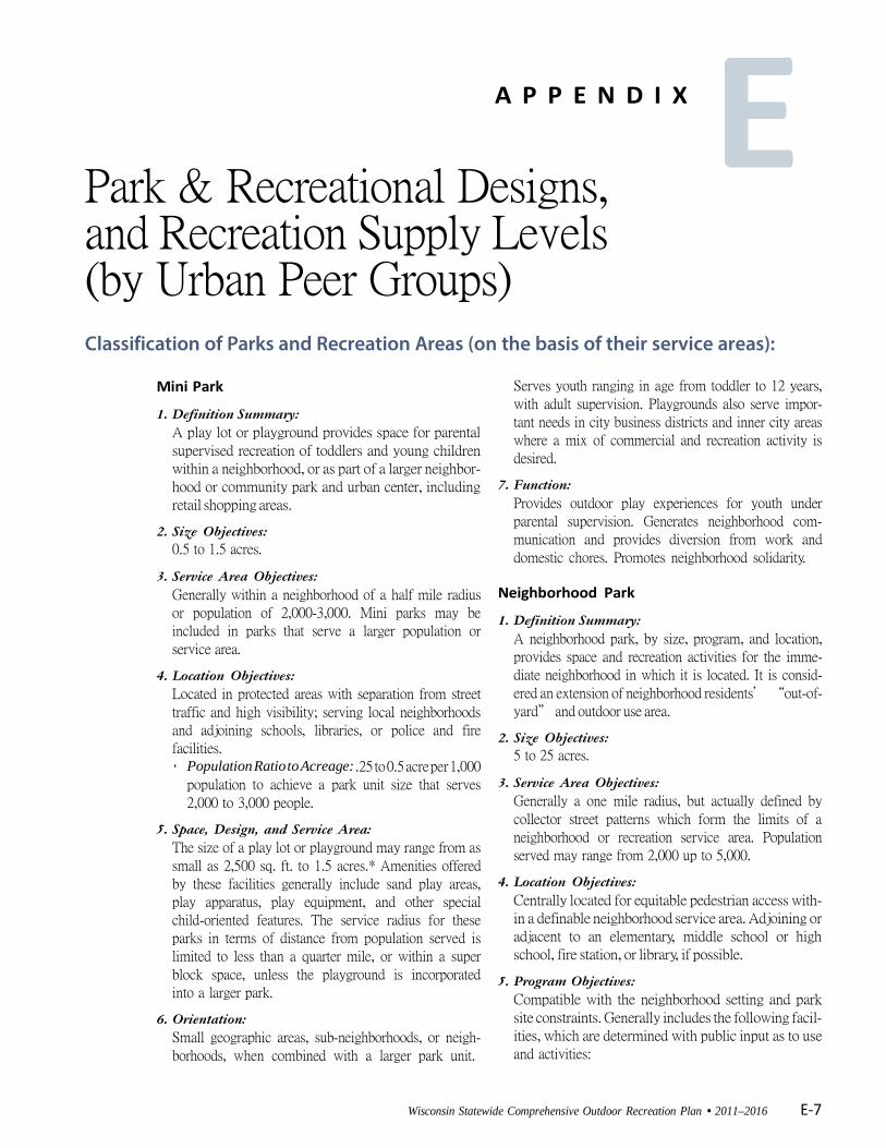
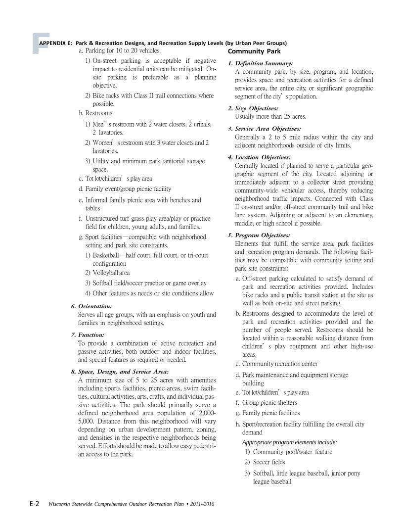
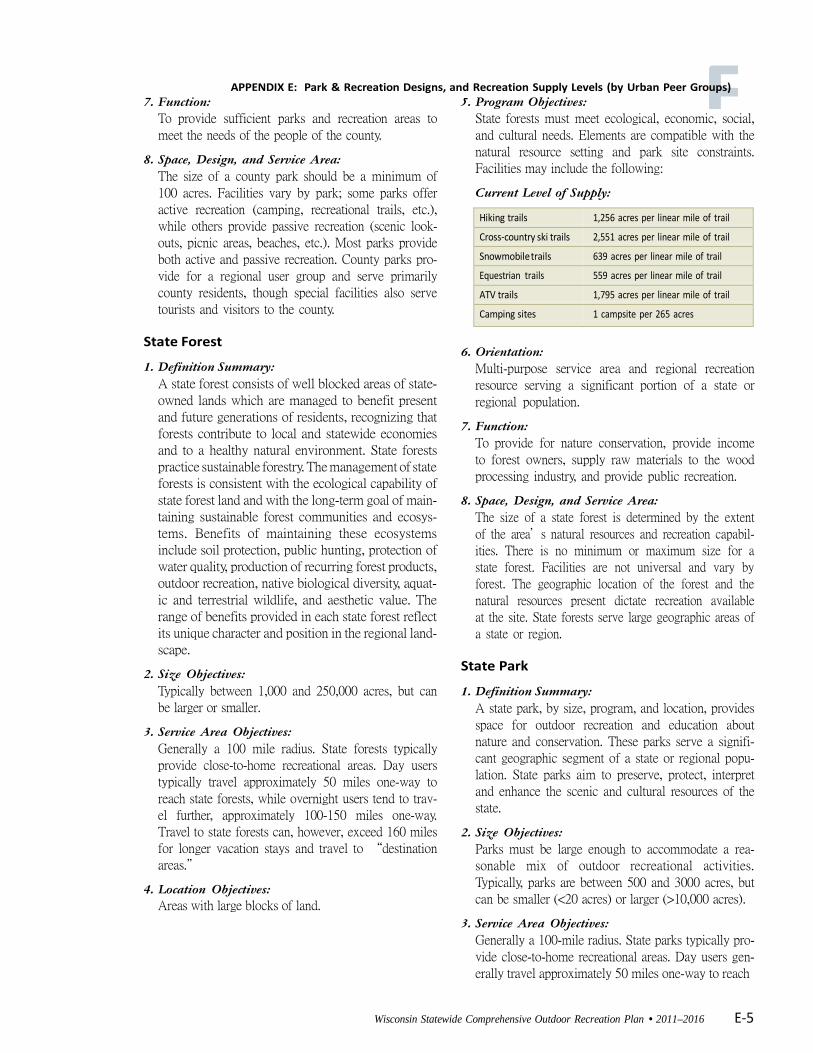
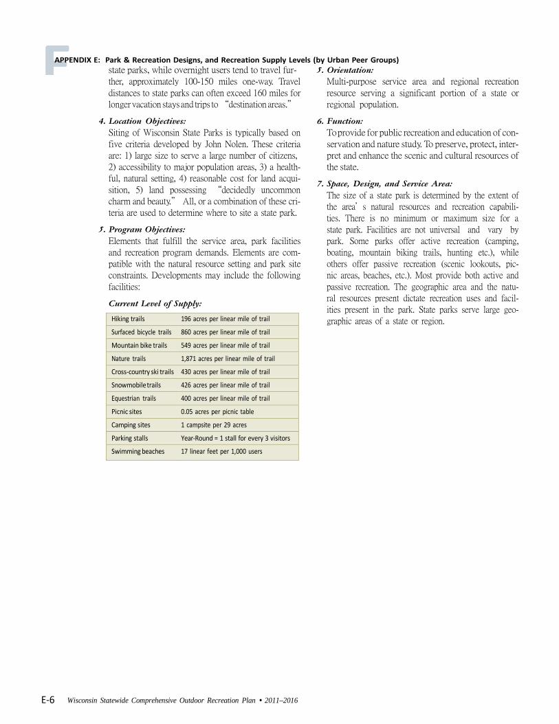
2.7 Outdoor Recreational Facility Development Standards Recreation systems are evaluated from a facility viewpoint in addition to an open space viewpoint to determine the amount of facility development needed in each recreation area. Traditional standards for the development of recreational facilities have been expressed in facility units per population ratio, similar to open space standards. Problems related to using traditional facility development standards include their assumptions of the recreational opportunities desired by the resident population. For example, an examination of the facilities standards may show that a second tennis court is needed based on the community’s population. In reality, it is possible that very few people in the community enjoy playing tennis, which may eliminate the need for this type of facility
Adopted by the Sauk County Board of Supervisors November 11, 2008 16
2013 Sauk County Comprehensive Outdoor Recreation Plan
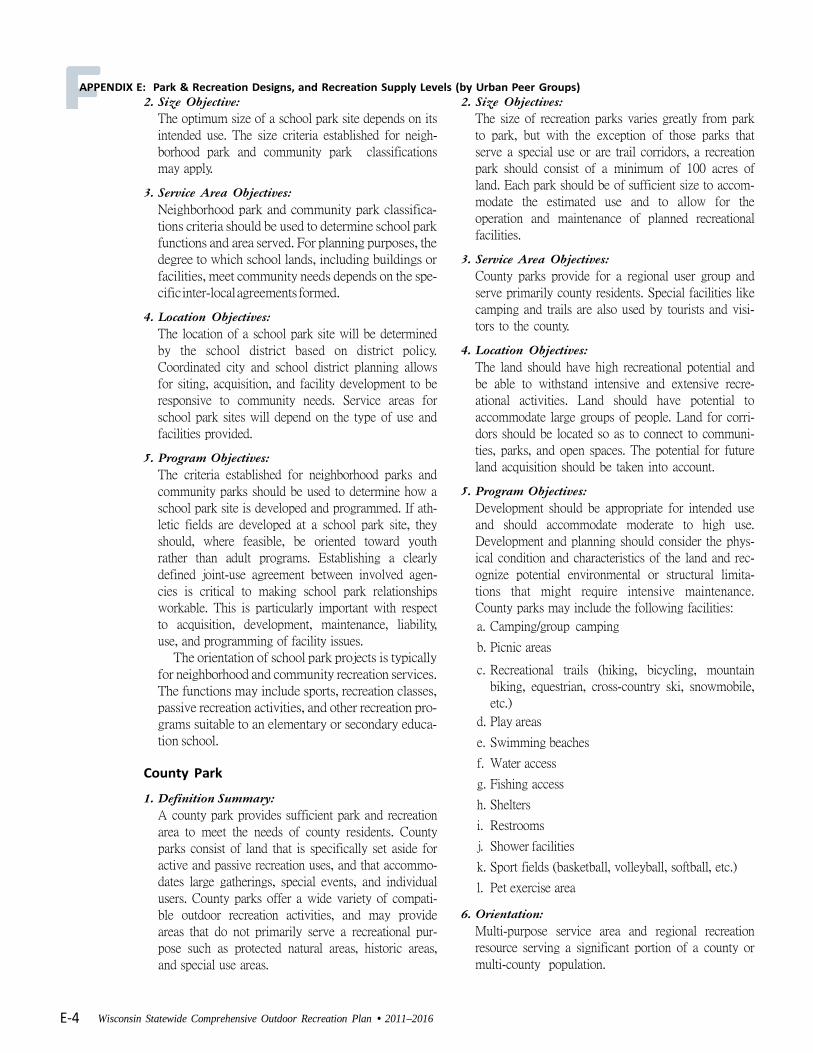
all together. Age, income, and education all contribute to people’s recreational preferences, yet facility standards sometimes ignore these variables. The National Recreation and Park Association for years published standards for the amount and types of park and recreation facilities to be provided per capita of population. Typically, the NRPA standard called for ten acres of park and recreation land per 1000 residents or 0.010 acres per capita. Since the 1990s NRPA, recognizing various local and regional differences, has renounced a “one size fits all” approach and recommends that communities identify their recreational space needs individually. NRPA advocates a public process, including open meetings, community surveys, personal conversations with stakeholder representatives and other techniques to establish the existing demand on facilities and to determine future needs. The Wisconsin State Comprehensive Outdoor Recreation Plan (SCORP) provides a discussion of park and recreation facility design at various scales from neighborhood mini parks to school parks, up to State forests and parklands. It addresses county parks design this way: “Space, Design and Service Area: The size of a county park should be a minimum of 100 acres. Facilities vary by park; some parks offer active recreation (camping, recreational trails, etc.), while others provide passive recreation (scenic lookouts, picnic areas, beaches, etc.). Most parks provide both active and passive recreation. County parks provide for a regional user group and serve primarily county residents, though special facilities also serve tourists and visitors to the county.” The Wisconsin SCORP lists Wisconsin counties in terms of the amount (acres) of land managed by each county. These lands include the publicly held lands at the state level. Sauk County has a total of 33,193 acres (2011-2016 Wisconsin SCORP, Appendix G), which makes the county 13th among Wisconsin’s 72 counties. Sauk County’s estimated 61,976 people in 2010 placed it 25th of 72 counties in population, but its location and interstate highway accessibility requires Sauk County and its public lands to serve a region that includes the Chicago, Milwaukee and Twin Cities metropolitan areas, whose combined population of over 20 million people live within a convenient four-hour drive. Appendix D shows SCORP information related to Park and Recreation Design 3.0 _Regional Setting 3.1 Location Sauk County is located in South-Central Wisconsin, 20 miles northwest of Madison, the state capital. It is about 100 miles northwest of Milwaukee, 173 miles northwest of Chicago, and approximately 250 miles southeast of Minneapolis-St. Paul.
Adopted by the Sauk County Board of Supervisors November 11, 2008 17
2013 Sauk County Comprehensive Outdoor Recreation Plan
Sauk County is about 840 square miles in size and consists of 3 cities, 14 villages and 22 towns. The population centers are the communities of Baraboo (county seat), Reedsburg, Prairie du Sac, Sauk City, Spring Green, and Lake Delton. 3.2 Climate The chart below illustrates how Sauk County exhibits a continental climate where temperature and precipitation vary with each season. Weather systems frequently move in an easterly fashion across the county. There are some micro-climatic variations depending on terrain and proximity to water. Generally, valleys experience freezing temperatures later in the spring and earlier in the fall than do the hillsides, as well as colder temperatures during the winter months than the flats or hilltops. The seasons each provide abundant unique opportunities for outdoor recreation. Chart 3-1: Annual Temperature and Precipitation Averages in Sauk County
Adopted by the Sauk County Board of Supervisors November 11, 2008 18
2013 Sauk County Comprehensive Outdoor Recreation Plan
4.0 Demographic and Economic Characteristics Sauk County continues to grow in size and population with residential areas growing at relatively high rates. Recreation preferences often vary with age, gender and income levels. In 2006 the Wisconsin Dept. of Tourism reported that Sauk County ranked third in overall tourism spending at $1.06 billion, falling only behind Milwaukee County at $1.6 billion and Dane County at $1.2B. The inviting and varied landscape, natural beauty, and cultural features found in Sauk County are the backbone of a large portion of local tourism and recreation. In order to protect the natural and cultural uniqueness of Sauk County while providing residents and tourists with adequate facilities, it is important to consider the data and trends throughout the decision making process. 4.1 Trends and Projections Population size and characteristics are very important in determining the size and number of parks and open space offered on a community and county level. Depending on where large population clusters are located is often the determining factor of where parks are located. The population of Sauk County, as of the 2010 census, is 61,976; the projected population for 2011 was 62,369 (approximately a 1% growth per year). The final 2012 Wisconsin DOA estimate for Sauk County is 62,597 a 1.0% increase over the 2010 census. Table 4-1: Sauk County Population Projections 2000-2030
Year 2000 2005 2010 2015 2020 2025 2030
Population 55,225 58,121 60,930 63,520 65,821 68,208 70,185
Source: U.S. Census
Age Composition Table 4-2: Sauk County Population Distribution by Gender and Trends Sauk County’s largest percentage of population lies between 25 and 54 years of age, with most of those people in their prime family raising years. Trends in housing development coupled with good schools and a desirable location indicate that the County’s population will continue to grow.
Description Population % Of Population
General Preference of Recreation Activity as outlined in SCORP
Male 30,848 49.8 Female 31,128 50.2
Under 5 years 3,979 6.4 5-9 years 4,014 6.5
10 to 14 years 4,170 6.7
15 to 19 years 3,930 6.3 Active recreation and motorized
activities
20 to 24 years 3,336 5.4 Active recreation and motorized
activities
25 to 34 years 7,734 12.40 Active recreation and motorized
activities
35 to 44 years 8,044 12.90 Active recreation and motorized
activities 45 to 54 years 9,545 15.40 Quieter and low impact activities 55 to 59 years 4,293 6.9 Quieter and low impact activities 60 to 64 years 3.643 5.90 Quieter and low impact activities 65 to 74 years 4,769 7.70 Quieter and low impact activities 75 to 84 years 2,962 4.80 Quieter and low impact activities 85 and older 1,557 2.50 Quieter and low impact activities
Median age 40.0
Adopted by the Sauk County Board of Supervisors November 11, 2008 19
2013 Sauk County Comprehensive Outdoor Recreation Plan
According to the Statewide Comprehensive Outdoor Recreation Plan (SCORP), younger generations tend to enjoy more active and motorized activities such as jogging, hiking, downhill skiing and ATV riding. Older generations seem to prefer quieter and low impact activities such as driving tours and wildlife viewing. SCORP also indicates that men are more apt to participate in hunting and ice fishing, while women are more apt to participate in visiting a dog park or swim in an outdoor pool. A chart and supporting text in the Wisconsin Land Legacy Report (WLLR) shows the number of adults in Wisconsin participating in selected outdoor recreation activities. This data seems to support the findings in SCORP, where older generations seem to prefer quieter and low impact activities and younger generations are more apt to enjoy active and motorized activities. Data obtained from the Wisconsin Dept. of Tourism by the Sauk County River Runners ATV Club claims 282,000 ATVs statewide, and an average user age of 40. Table 4-3: Adult Participation in Selected Outdoor Recreation Activities
Activity Number of Adults Age Group Wildlife viewing over 2,000,000. Usually 50 and older
Hiking over 1,500,000. Usually 40 and younger Fishing over 1,500,000. More men than women
Nature Study/Bird Watching over 1,500,000. Usually 50 and older Motoring Boating approximately 1,500,000. Usually 40 and younger
Camping with a tent over 500,000. Not listed Hunting over 500,000. More men than women
Off road biking over 500,000. Usually 40 and younger Canoeing over 500,000. Not listed
Snowmobiling approximately 500,000. Usually 40 and younger Cross-country skiing approximately 500,000. Not Listed
Camping with a RV approximately 500,000. Usually 50 and older
ATV riding approximately 250,000. Usually 40 and younger
4.2 Ethnic Background Sauk County is predominately comprised of White/non-Hispanics. For this group, the type of recreational activities enjoyed varies by gender, education and economic status. According to SCORP, minority groups also enjoy a variety of outdoor recreation activities, though they tend to utilize nature based educational and family oriented opportunities. Table 4-4: Sauk County Ethnic Population Distribution and Recreational Preferences
Ethnicity Population % Of Population General Preference of Recreation Activity as
outlined in SCORP
White 58,588 94.5% varies Black, African American 357 0.6% Nature based educational and family oriented activities
American Indian, Alaska Native 769 1.2% Nature based educational and family oriented activities
Asian 337 0.5% Nature based educational and family oriented activities Native Hawaiian, Other Pacific
Islander 13 0.0% Nature based educational and family oriented activities
Other 1,156 1.9%
Two Or More Races 756 1.2%
Adopted by the Sauk County Board of Supervisors November 11, 2008 20
2013 Sauk County Comprehensive Outdoor Recreation Plan
4.3 Education Table 4-5: Sauk County Educational Attainment The 2010 Census indicates that 20.1 % of Sauk County residents have a bachelor’s degree or higher. SCORP indicates that the primary recreation activities for those with graduate or professional degrees (6.5%) are nature-based activities such as wildlife viewing, hiking, snow-shoeing. Those with some college or a bachelor’s degree (43.3%) seem to participate in a wide variety of activities. 4.4 Income Levels and Economy Income levels can influence the type Table 4-6: Sauk County Income Distribution of recreational activities people choose. SCORP shows that middle-income families tend to enjoy activities such as camping, hiking, fishing, picnicking and ATV riding. Higher income families will participate in a variety of activities including jogging, hiking and visiting historic homes, and be more apt to participate in activities such as golf, downhill skiing and motor-boating. A look at the most recent census data shows that 72.2 % of Sauk County residents are in the labor force, with only 4% unemployed.
EDUCATIONAL ATTAINMENT Population 25 years and
over 42,155 100 % Less than 9th grade 1,566 3.7
9th to 12th grade, no diploma 3,341 7.9 High school graduate (includes equivalency) 16,209 38.5
Some college, no degree 8,870 21
Associate degree 3,674 8.7
Bachelor's degree 5,748 13.6 Graduate or professional
degree 2,747 6.5
Percent high school graduate
or higher 88.4 (X) Percent bachelor's degree or
higher 20.2 (X)
INCOME IN 2011 Households 25,504 100 %
Less than $10,000 1,205 4.7
$10,000 to $14,999 1,320 5.2
$15,000 to $24,999 3,116 12.2
$25,000 to $34,999 2,622 10.3
$35,000 to $49,999 4,121 16.2
$50,000 to $74,999 5,642 22.1
$75,000 to $99,999 3,702 14.5
$100,000 to $149,999 2,771 10.9
$150,000 to $199,999 598 2.3
$200,000 or more 407 1.6
Median household income (dollars) 51,121 (X)
Adopted by the Sauk County Board of Supervisors November 11, 2008 21
2013 Sauk County Comprehensive Outdoor Recreation Plan
Table 4-7: Sauk County Labor Force Employment Status
Employment Status Number in Sauk County Percent in Sauk County
In Labor Force 35,047 72.2%
Armed Forces 76 0.2%
Civilian Labor Force 34,971 72.0%
Employed 32,845 67.7%
Unemployed 2,126 4.00%
Much of Sauk County’s economy is based on agriculture, construction and manufacturing. Although Sauk County’s tourist spending relies heavily on the Wisconsin Dells area, which boasts a large number of water parks and tourist attractions, the County’s abundant and unique natural features draw significant numbers of visitors, and remain the basis of Sauk County’s long-term viability as a destination and, more importantly, as a livable community. A comprehensive economic analysis might reveal tourism as a tool capable of generating interest in the health and protection of the natural resources that form the basis of the tourism industry and, in fact, of the entire economy. The concept of Civic Tourism promotes view of tourism as “an enabler of healthy place-making, not only as an economic tool.” Sauk County could maximize its recreational advantage in the fact that tourists spend
over a billion dollars a year locally by educating visitors on the value of County’s natural resources and scenic areas, and by setting aside a portion of the tourist revenues to preserve and enhance those assets.
Adopted by the Sauk County Board of Supervisors November 11, 2008 22
2013 Sauk County Comprehensive Outdoor Recreation Plan
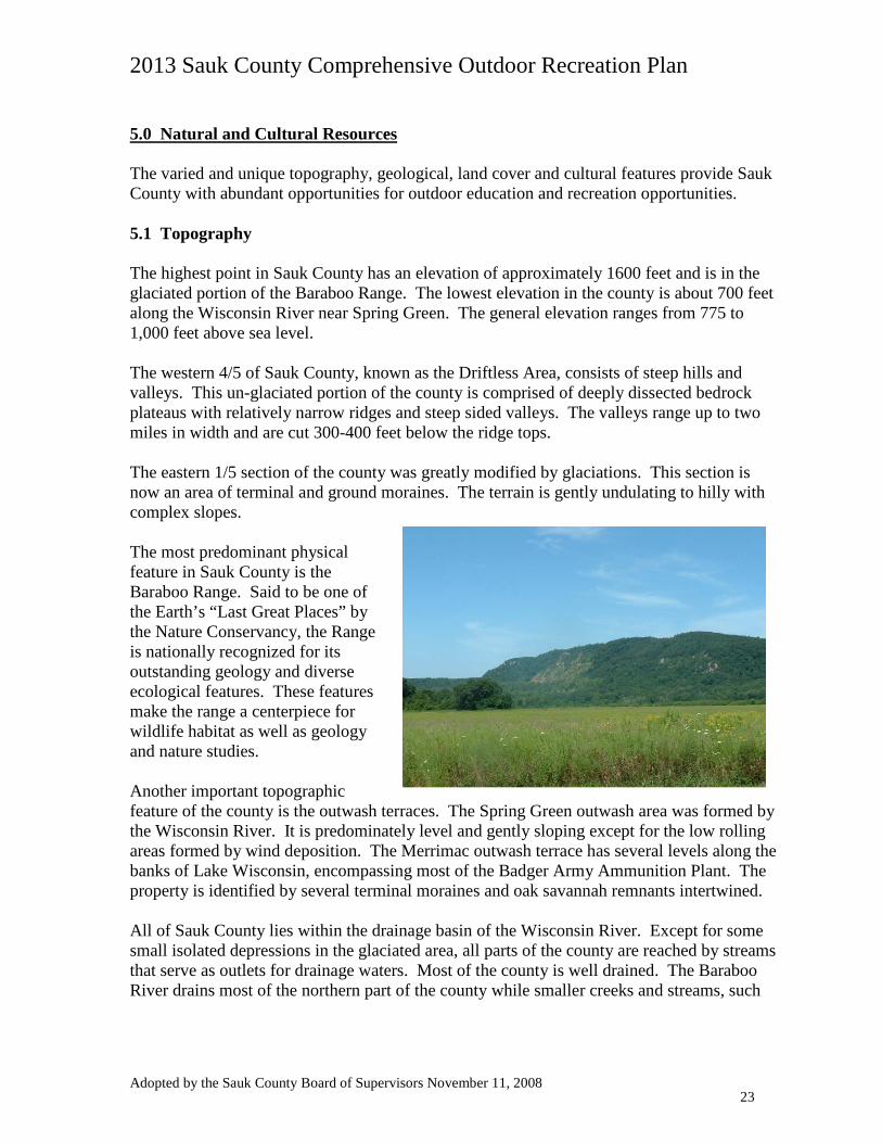
5.0 Natural and Cultural Resources The varied and unique topography, geological, land cover and cultural features provide Sauk County with abundant opportunities for outdoor education and recreation opportunities. 5.1 Topography The highest point in Sauk County has an elevation of approximately 1600 feet and is in the glaciated portion of the Baraboo Range. The lowest elevation in the county is about 700 feet along the Wisconsin River near Spring Green. The general elevation ranges from 775 to 1,000 feet above sea level. The western 4/5 of Sauk County, known as the Driftless Area, consists of steep hills and valleys. This un-glaciated portion of the county is comprised of deeply dissected bedrock plateaus with relatively narrow ridges and steep sided valleys. The valleys range up to two miles in width and are cut 300-400 feet below the ridge tops. The eastern 1/5 section of the county was greatly modified by glaciations. This section is now an area of terminal and ground moraines. The terrain is gently undulating to hilly with complex slopes. The most predominant physical feature in Sauk County is the Baraboo Range. Said to be one of the Earth’s “Last Great Places” by the Nature Conservancy, the Range is nationally recognized for its outstanding geology and diverse ecological features. These features make the range a centerpiece for wildlife habitat as well as geology and nature studies. Another important topographic feature of the county is the outwash terraces. The Spring Green outwash area was formed by the Wisconsin River. It is predominately level and gently sloping except for the low rolling areas formed by wind deposition. The Merrimac outwash terrace has several levels along the banks of Lake Wisconsin, encompassing most of the Badger Army Ammunition Plant. The property is identified by several terminal moraines and oak savannah remnants intertwined. All of Sauk County lies within the drainage basin of the Wisconsin River. Except for some small isolated depressions in the glaciated area, all parts of the county are reached by streams that serve as outlets for drainage waters. Most of the county is well drained. The Baraboo River drains most of the northern part of the county while smaller creeks and streams, such
Adopted by the Sauk County Board of Supervisors November 11, 2008 23
2013 Sauk County Comprehensive Outdoor Recreation Plan
as Honey Creek, drain the southern part of the county. Many of the streams are fed by permanent springs, with wetlands generally found in the bottomlands of streams and rivers. 5.2 Land Cover and Land Use Map 5-1 shows the Land Use and Land Cover in Sauk County. Grasslands According to the 2007 Sauk County Land and Water Resource Plan, nearly half of the pre-settlement Sauk County landscape was characterized by the “Oak savannas, mesic and dry prairies”. The Sauk Prairie stretched across 14,000 acres west and northwest of present day villages of Sauk City and Prairie du Sac. The “Wisconsin Desert” covered about 13,000 acres near the present day village of Spring Green on the sand terraces of the Wisconsin River. Two additional prairies included Pleasant Prairie (2,200 acres), located north of the city of Baraboo and Cassell Prairie (1,200 acres) located along the Wisconsin River between the villages of Sauk City and Spring Green. There were also numerous smaller native prairies through the County. Grassland prairies and savannas today represent less than one-half of one percent of the original prairies in Sauk County. Agriculture Agricultural lands beyond the steep slopes of the Baraboo Range largely dominate Sauk County. The 2006 Wisconsin Land Legacy Report (WLLR) highlights the importance of agricultural lands. Farms provide open space and buffers between development and habitat areas, large blocks of undeveloped land, scenic vistas, as well as corridors that help to facilitate species movement. Our Farmlands: Issues and opportunities The WLLR points out that while non-point pollution from agriculture lands is a concern, preserving large tracts of farmland though programs such as Purchase of Development Rights (PDR) can help buffer and protect wetlands, woods, etc. Targeting protection of conservation areas near working farms may help protect family farm owners from being squeezed out by real or anticipated development pressures. Private and public prairie restoration projects, including the restoration of the 7,300 acre former Badger Army Ammunition Plant on the historic Sauk Prairie, offer the potential of “demonstrating the profitability and environmental stewardship of grassland farming using managed grazing techniques.” Recreational uses of grassland, prairie, and savanna landscapes include hiking, bird-watching and other wildlife viewing.
Adopted by the Sauk County Board of Supervisors November 11, 2008 24
2013 Sauk County Comprehensive Outdoor Recreation Plan
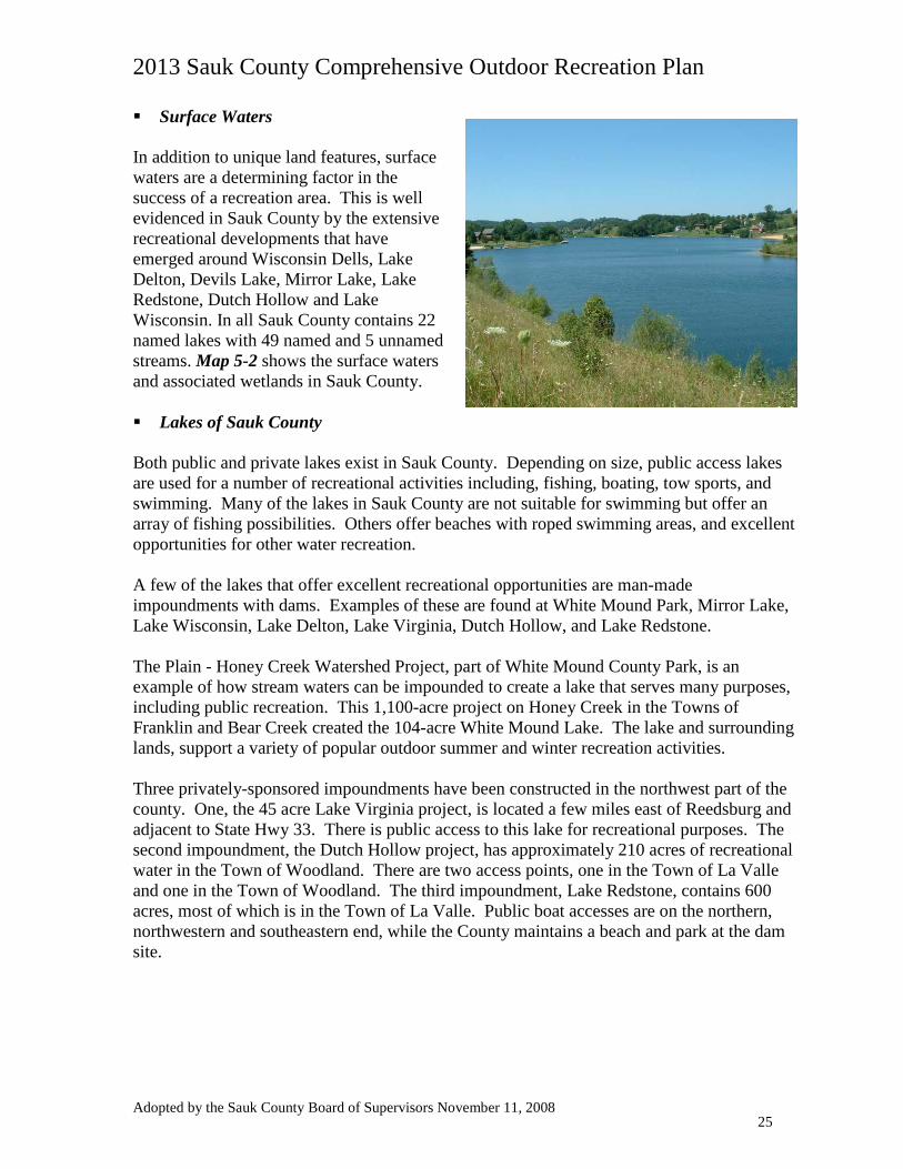
Surface Waters In addition to unique land features, surface waters are a determining factor in the success of a recreation area. This is well evidenced in Sauk County by the extensive recreational developments that have emerged around Wisconsin Dells, Lake Delton, Devils Lake, Mirror Lake, Lake Redstone, Dutch Hollow and Lake Wisconsin. In all Sauk County contains 22 named lakes with 49 named and 5 unnamed streams. Map 5-2 shows the surface waters and associated wetlands in Sauk County.
Lakes of Sauk County Both public and private lakes exist in Sauk County. Depending on size, public access lakes are used for a number of recreational activities including, fishing, boating, tow sports, and swimming. Many of the lakes in Sauk County are not suitable for swimming but offer an array of fishing possibilities. Others offer beaches with roped swimming areas, and excellent opportunities for other water recreation. A few of the lakes that offer excellent recreational opportunities are man-made impoundments with dams. Examples of these are found at White Mound Park, Mirror Lake, Lake Wisconsin, Lake Delton, Lake Virginia, Dutch Hollow, and Lake Redstone. The Plain - Honey Creek Watershed Project, part of White Mound County Park, is an example of how stream waters can be impounded to create a lake that serves many purposes, including public recreation. This 1,100-acre project on Honey Creek in the Towns of Franklin and Bear Creek created the 104-acre White Mound Lake. The lake and surrounding lands, support a variety of popular outdoor summer and winter recreation activities. Three privately-sponsored impoundments have been constructed in the northwest part of the county. One, the 45 acre Lake Virginia project, is located a few miles east of Reedsburg and adjacent to State Hwy 33. There is public access to this lake for recreational purposes. The second impoundment, the Dutch Hollow project, has approximately 210 acres of recreational water in the Town of Woodland. There are two access points, one in the Town of La Valle and one in the Town of Woodland. The third impoundment, Lake Redstone, contains 600 acres, most of which is in the Town of La Valle. Public boat accesses are on the northern, northwestern and southeastern end, while the County maintains a beach and park at the dam site.
Adopted by the Sauk County Board of Supervisors November 11, 2008 25
2013 Sauk County Comprehensive Outdoor Recreation Plan
Lake Wisconsin, Lake Delton, Lake Redstone, and Mirror Lake are the more established impoundments and have developed shorelines. These lakes provide the county residents and tourists with many recreational opportunities as well as permanent and seasonal home sites. The county’s Land Conservation Committee is responsible for providing oversight for the maintenance of Lake Redstone, Hemlock Lake, White Mound Lake and Mirror Lake dams. The following table lists the named lakes and their size in acres (Devil’s Lake is described later in the Plan). Table 5-1: Sauk County’s Named Lakes
Sauk County Named Lakes Size (Acres) Bakkens Pond 14 Blass Lake 34 Cynthia Slough 13 Deacon Thomas Lake 11 Delton Lake 267 Devils Lake 369 Dutch Hollow Lake 210 Hemlock Slough 12 Hill Slough 4 Hutter Slough 10 Jones Slough 5 Lake of the Dells 13 Leland Millpond 14 Long Lake 4 Mirror Lake 137 Norton Slough 9 Redstone Lake 612 Seeley Lake 49 Virginia Lake 35 White Mound Lake 104 Wisconsin Lake 9100 Wood Slough 4 TOTAL 11030
Adopted by the Sauk County Board of Supervisors November 11, 2008 26
2013 Sauk County Comprehensive Outdoor Recreation Plan
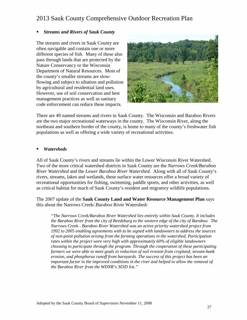
Streams and Rivers of Sauk County The streams and rivers in Sauk County are often navigable and contain one or more different species of fish. Many of these also pass through lands that are protected by the Nature Conservancy or the Wisconsin Department of Natural Resources. Most of the county’s smaller streams are slow-flowing and subject to siltation and pollution by agricultural and residential land uses. However, use of soil conservation and best management practices as well as sanitary code enforcement can reduce these impacts. There are 49 named streams and rivers in Sauk County. The Wisconsin and Baraboo Rivers are the two major recreational waterways in the county. The Wisconsin River, along the northeast and southern border of the county, is home to many of the county’s freshwater fish populations as well as offering a wide variety of recreational activities. Watersheds All of Sauk County’s rivers and streams lie within the Lower Wisconsin River Watershed. Two of the more critical watershed districts in Sauk County are the Narrows Creek/Baraboo River Watershed and the Lower Baraboo River Watershed. Along with all of Sauk County’s rivers, streams, lakes and wetlands, these surface water resources offer a broad variety of recreational opportunities for fishing, swimming, paddle sports, and other activities, as well as critical habitat for much of Sauk County’s resident and migratory wildlife populations. The 2007 update of the Sauk County Land and Water Resource Management Plan says this about the Narrows Creek/.Baraboo River Watershed:
“The Narrows Creek/Baraboo River Watershed lies entirely within Sauk County. It includes the Baraboo River from the city of Reedsburg to the western edge of the city of Baraboo. The Narrows Creek - Baraboo River Watershed was an active priority watershed project from 1992 to 2005 enabling agreements with to be signed with landowners to address the sources of non-point pollution arising from the farming operations in the watershed. Participation rates within the project were very high with approximately 60% of eligible landowners choosing to participate through the program. Through the cooperation of these participating farmers we were able to meet goals in reduction of soil erosion from cropland, stream-bank erosion, and phosphorus runoff from barnyards. The success of this project has been an important factor in the improved conditions in the river and helped to allow the removal of the Baraboo River from the WDNR’s 303D list.”
Adopted by the Sauk County Board of Supervisors November 11, 2008 27
2013 Sauk County Comprehensive Outdoor Recreation Plan
The Baraboo River, one of the longest restored free flowing rivers east of the Mississippi River, is host to many rare and endangered plants and animals. Plant species include species typically found much further north. Several headwater creeks contain trout. Considerable stream and stream bank improvements on the Baraboo River has been completed, thus enhancing the stream's health and increasing quality recreation opportunities such as canoeing. The river is considered a Land Legacy in the WLLR with the following statistics:
Recreation Potential 4 Stars The 2007 Land and Water Resource Management Plan says also details work accomplished on the Lower Baraboo River watershed:
“Studies have also shown a much improved game fishery in the Baraboo River and some of its branch streams. The river was removed from the DNR 303D listing in 2006 and is seeing steadily increasing use by the public. Several canoe liveries are now operating on the river and the number of canoe and kayak users has increased significantly over the last 10 years. The City of Baraboo has initiated an extensive riverfront revitalization project and other communities along the river are also looking at ways to better use the resource. Fishing in the rapids areas in the city of Baraboo is now a regular occurrence where it was unheard of only five years ago.”
Other priority watershed projects described in the Land and Water Resource Management Plan include the Crossman Creek/Little Baraboo River Watershed (which extends north into Juneau County), the Bear Creek Watershed, the Honey Creek Watershed, the Lake Wisconsin Watershed, the Dell Creek Watershed and the Willow Creek Watershed. The following tables show all the named and unnamed streams and creeks in Sauk County as well as their surface area and length. Table 5-2: Sauk County’s Unnamed Streams
Location of Sauk County’s Unnamed Streams Surface Area (Acres) Length (Miles)
Bear Creek Township 1.09 3 Washington Township 1.21 2
Baraboo Township 0.18 0.5
Greenfield Township 0.3 1.25
Delton Township 0.36 0.75
Total 7549.55 337.12
Adopted by the Sauk County Board of Supervisors November 11, 2008 28
2013 Sauk County Comprehensive Outdoor Recreation Plan
Table 5-3: Sauk County’s Named Streams
Please continue to next page…
Sauk County Named Streams Surface Area (acres) Length (miles) Babbs Creek 3.72 6.13 Baraboo River (A land legacy) 267.31 63 Bear Creek 7.33 7.2 Beaver Creek 1.35 1.59 Big Creeks 0.15 0.25 Bondy Valley 0.48 1.6 Camels Creek 1.32 1.81 Carr Valley Creek 3.03 5 Cazenovia Branch 3.03 2.5 Copper Creek 2.13 3.2 Crossman Creek 1.97 2.5 Dell Creek 17.82 10.5 Dutch Hollow Creek 0.64 1.5 East Branch of Big Creek 0.97 2 Ela Valle Creek 0.83 2.75 Furnace Creek 1.92 3.95 Gardner Creek 0.09 0.25 Harrison Creek 1.54 7.26 Hay Creek 2.79 5.75 Hillpoint Creek 2.91 4 Honey Creek 45.46 25 Hulburt Creek 4.07 3.5 Jones Valley Creek 0.05 0.3 Leech Creek 7.27 6 Little Baraboo River 23.64 13 Little Bear Creek 2.85 5.6 Mortimer Valley Creek 0.65 1.8 Narrows Creek 44.58 18.5 North Branch of Honey Creek 9.82 9 Otter Creek 2.91 6 Ox Creek 0.39 2.13 Parfrey's Glen Creek 0.53 1.1 Pine Creek 0.85 3.5 Plum Creek 2.91 6 Punkin Hollow Creek 0.18 0.75 Rowley Creek 1.67 2.75 Seeley Creek 13.34 11 Shannahan Valley Creek 1.45 3 Silver Creek 0.79 3.25 Skillet Creek 2.91 6 Smith Hollow Creek 0.24 1 Spring Brook 1.91 1.75 Spring Valley Creek 1.1 2.25 Sugar Grove Valley Creek 1.85 5.1 Twin Creek 4.09 7.5 West Branch of Big Creek 0.61 1 Willow Creek 0.47 1.3 Wilson Creek 3.49 5.75 Wisconsin River 7045 43.05
Adopted by the Sauk County Board of Supervisors November 11, 2008 29
2013 Sauk County Comprehensive Outdoor Recreation Plan
Sauk County’s Waters: Issues and opportunities Wetlands are a key component of supporting outdoor recreation activities such as wildlife viewing, hunting and fishing, as well as enjoying scenic vistas while boating or hiking. Wetlands, which are generally found near many of our lakes and streams, are critical to environmental habitat and health. Wetland communities support the highest abundance of plant and animal life, act as sponges to protect us during floods, as well as filter excessive nutrients from runoff. It is true that while wetlands may be protected from filling or other types of development, they are not well protected from being drained, especially for existing agricultural purposes. Invasive species are an issue affecting wetlands as well. Both the function (quality) and quantity of wetlands are diminishing. WLLR outlines some protection potential through outreach and technical assistance programs, incentive programs (prop tax reduction), use of CREP, CRP, and WRP programs. Since protecting all wetlands may seem an overwhelming task, the WLLR suggests targeting large sedge meadows and marshes; high-quality cattail and bulrush marshes (shallow and deep), especially adjacent to lakes; wild rice lakes and bogs; Great Lakes wetlands; wetlands for migrating and breeding waterfowl and shorebirds; as well as wetland areas critical to hydrology and water quality. The 2007 Land and Water Resource Management Plan addresses wetlands and their importance:
“These different types of wetlands have important functions. They protect shorelines, shelter rare and endangered species of plants and animals, and remove nutrients and pesticides from surface water and groundwater. Some wetlands filter out sediment before it reaches the surface waters of the County. Many wetlands slow the overland flow of water and thus reduce flooding and soil erosion downstream. Currently, wetlands comprise approximately 1 percent of the land area in Sauk County. During early settlement times, wetlands encompassed an estimated 20 percent of the County. The greatest concentrations of prime wetlands consisting of shallow and deep marsh, shrub swamp, and timber swamps are located along the Wisconsin River, Honey Creek, Baraboo River above the city of Reedsburg, and Dell Creek above Mirror Lake. Existing wetlands are declining in quality as well. They are impacted by sediment accumulations and invasive species.”
Clearly, wetlands have importance not only from an ecological perspective, but as major recreational attributes important to Sauk County residents and visitors alike. The WLLR points out that surface water may be a source of drinking water as well as resource for outdoor recreational activities. Some of the most identifiable challenges to protecting water quality include: both point and non-point pollution; finding a balance between the varied uses, particularly motorized and non-motorized uses; and finally, building along shore-land areas.
Protecting shore lands helps to protect some wetlands and native species, and also the quality of water in the water body. An integrated program of landowner incentives, reasonable regulations and permanent land protection efforts affords the most effective combination of strategies to address conservation issues at a watershed level.
Adopted by the Sauk County Board of Supervisors November 11, 2008 30
2013 Sauk County Comprehensive Outdoor Recreation Plan
Woodlands Much of Sauk County is covered with stands of bur, white and black oak. Sugar maple and basswood also make up a large portion of the county’s wooded areas. Many of the woodlands in Sauk County are private. The WDNR and The Nature Conservancy manage some areas, allowing hunting on a restricted basis. They also provide a variety of other low-impact public recreational opportunities such as hiking, birding, cross-country skiing and snowshoeing. As pointed out in the 2007 Land and Water Resource Management Plan, “The forest contributes to the county’s economy providing wood products and supporting ecotourism.” The Baraboo Hills contain one of the largest contiguous upland hardwood forests in the Midwest. The Baraboo Hills forests are home to incredible diversity, including more than 1,800 plant and animal species, many of which are rare. The Baraboo Hills are the site of two state parks and several State Natural Areas. Devil’s Lake State Park / Ice Age National Scientific Reserve attracts over one million visitors each year to Sauk County. Natural Bridge State Park near Leland in the neighboring Town of Honey Creek is the scene of one of the northern hemisphere’s most distinctive natural stone arches. The Parfrey’s Glen property on the South Range east of Devil’s Lake was designated Wisconsin’s first State Natural Area and remains a popular regional attraction. Baxter’s Hollow, Pine Hollow and several other properties owned by The Nature Conservancy are open to public access for wildlife viewing, bird watching and, in season, controlled hunting. Woodlands: Issues and opportunities According the WLLR, forests are home to numerous species of trees, shrubs, grasses and animals. Large contiguous tracts are critical for acting as a source of food and cover for many species. Large tracts may be established and/or preserved through creation of connective corridors and the protection of contiguous lands. Forest corridors (e.g. lowlands along river ways) offer ways to connect many types of habitats. While not all forests are necessarily threatened directly by people or human activity, fragmented and absentee private ownership patterns might result in less effective management for enhancing wildlife habitat or to control invasive species. Offering educational outreach efforts to landowners as well as providing management tools and resources are important to manage this resource. 5.3 Cultural Features
Public/private partnerships designed to achieve well-managed conservation and recreational uses of Sauk County’s vast forests will enhance public awareness of their aesthetic, ecological and economic importance.
Adopted by the Sauk County Board of Supervisors November 11, 2008 31
2013 Sauk County Comprehensive Outdoor Recreation Plan
Cultural features lend too many types of passive and active recreational opportunities. Many of the rural roads provide hikers, bikers and motorists outstanding vistas of agriculture and other natural features. Historical landmarks and archeological sites provide sightseers and motorists a glimpse of the past. Sauk County is blessed with many cultural points of interest.
Rustic Roads
Rustic Roads provide access to those who live along them but also provide bikers, hikers, and motorists an opportunity for leisurely travel through some of Sauk County’s most scenic countryside. Rustic Roads offer open agricultural vistas or outstanding natural features such as rugged terrain, native vegetation, and native wildlife. Rustic Roads often aid understanding of the natural and cultural attributes that help define our ‘Sense of Place’
In Sauk County, there are two Rustic Roads, #21 and # 49. Rustic Road #21 is located between the hamlets of Denzer and Leland in the Township of Honey Creek just off County Highway PF. This 8.6-mile stretch of primarily gravel road follows portions of Schara Road, Ruff Road, Orchard Drive and Slotty Road. Skirting Natural Bridge State Park, this stretch is marked by rugged rolling terrain, stands of oak, maple, basswood and hickory, roadside wildflowers and agriculture vistas. http://www.dot.wisconsin.gov/travel/scenic/rusticroad21.htm
Rustic Road #49 is a 9.8-mile stretch traversing the paved Levee Road through both Sauk and Columbia Counties. Levee road takes you along the Wisconsin River and passes through the Aldo Leopold Reserve. Hikers, bikers and motorists are treated to outstanding vistas of the Wisconsin River, marshlands and prairies.
2013 Sauk County Comprehensive Outdoor Recreation Plan
For the purposes of this plan, areas of historic significance are defined as districts, structures or areas that have been placed on the National Register of Historic Places (NRHP), on the Wisconsin Register of Historic Places (WRHP) or contain a Historical Marker. Areas of historic significance lend mostly to passive recreation opportunities such as sightseeing and driving tours.
The Sauk County Arts, Humanities and Historic Preservation Commission website contains a list of the County’s historic and cultural resources, such as the Circus World Museum, the H.H. Bennett Studio and History Center, the Mid-Continent Railway Historical Society and others, including specific area historic resources and historic preservation organizations. The website address is http://www.co.sauk.wi.us/dept/arts/07_cultural_resources_directory.pdf.
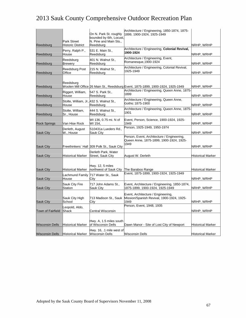
Currently, 56 locations in Sauk County have a Historical Marker, are on the National Register of Historic Places (NRHP) or on the Wisconsin Register of Historic Places (WRHP). Appendix B lists Sauk County’s Registered Historical Attractions.
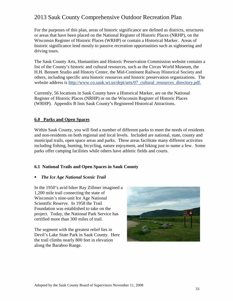
6.0 Parks and Open Spaces Within Sauk County, you will find a number of different parks to meet the needs of residents and non-residents on both regional and local levels. Included are national, state, county and municipal trails, open space areas and parks. These areas facilitate many different activities including fishing, hunting, bicycling, nature enjoyment, and hiking just to name a few. Some parks offer camping facilities while others have athletic fields and courts. 6.1 National Trails and Open Spaces in Sauk County The Ice Age National Scenic Trail In the 1950’s avid hiker Ray Zillmer imagined a 1,200 mile trail connecting the state of Wisconsin’s nine-unit Ice Age National Scientific Reserve. In 1958 the Trail Foundation was established to take on the project. Today, the National Park Service has certified more than 300 miles of trail. The segment with the greatest relief lies in Devil’s Lake State Park in Sauk County. Here the trail climbs nearly 800 feet in elevation along the Baraboo Range.
Adopted by the Sauk County Board of Supervisors November 11, 2008 33
2013 Sauk County Comprehensive Outdoor Recreation Plan
Map 6-1: The Ice Age National Scenic Trail
Throughout the state there are over 250 miles of trail segments that have not yet been certified as official National Ice Age Trail. These segments remain open to the public for their enjoyment. Badger Army Ammunition Plant Badger Army Ammunition Plant, labeled FO1 on Map 6-2 is located in the Towns of Sumpter and Merrimac. Badger Army Ammunition Plant, a land legacy in the Wisconsin Land Legacy Report, is approximately 7300 acres with 21 of the 103 present bird species containing critical status. There is great potential to provide connectivity and continuation of grassland and oak forest with the adjacent Land Legacy: Baraboo Hills as well as the conservation areas of Devils Lake State Park, Parfrey’s Glen, and the Lower Wisconsin State Riverway. The Wisconsin Land Legacy Report gives the following statistics:
Size Medium Protection Initiated Substantial Protection Remaining Limited
Current planning processes offer opportunities for establishing links to the Ice Age National Scenic Trail from numerous locations in Sauk County.
Adopted by the Sauk County Board of Supervisors November 11, 2008 34
2013 Sauk County Comprehensive Outdoor Recreation Plan
Conservation Significance 4 Stars Recreation Potential 4 Stars The Badger property is undergoing a disposition process under the direction of the federal General Services Administration. About 1,700 acres of the property has been transferred to the U.S.D.A. on behalf of the U.S. Dairy forage Research Center, primarily for agricultural and dairy forage research purposes. Another 1500 acres has been identified for transfer to the Dept. of Interior, Bureau of Indian Affairs on behalf of the Ho-Chunk Nation, primarily for bison husbandry and native prairie restoration. The remaining approx. 4,100 acres will likely be conveyed to the Wisconsin Dept. of Natural Resources, mainly to provide low-impact recreational opportunities as well as for a variety of ecological restoration and wildlife habitat rehabilitation and related scientific research projects. The Badger property is located in the shadow of the South Bluff of the Baraboo Range, directly adjacent to Devil’s Lake State Park, and links that internationally renowned resource with the Lower Wisconsin State Riverway. It is bisected by the terminal moraine of the last glacier. Nearby to the northeast lies the 8,000-acre Merrimac Preserve of the Riverland Conservancy, shown as PO2 on Map 6-2. These factors combine to yield a regional natural and cultural resource of distinct importance. Potential recreational uses at Badger include hiking, bicycling, camping, birdwatching and wildlife viewing, hunting, boating, fishing and swimming from Badger’s locations on the Lake Wisconsin shoreline. 6.2 State Parks, Trails and Major State Properties in Sauk County The “400” State Trail From Elroy to Juneau County, the “400” State Trail is a 22.3-mile trail that provides many Sauk County residents and visitors with recreational opportunities. The trail allows a variety of recreational activities including hiking, horseback riding, bicycle touring and snowmobiling. The “400” State Trail was developed on an abandoned Chicago-Northwestern Railroad line between Minneapolis/St. Paul and Chicago that could be traveled
The regional recreational trail potential in this area is unmatched, given the possibility of connecting rails-to-trails projects from Dane County across the Wisconsin River, through the Villages of Sauk City and Prairie du Sac, across the Badger property. This trail could then continue north into Devil’s Lake State Park and beyond to link with the Wisconsin Dells via the Ice Age Trail, and to the “400” State Recreational Trail out of Reedsburg.
Adopted by the Sauk County Board of Supervisors November 11, 2008 35
2013 Sauk County Comprehensive Outdoor Recreation Plan
by train in only 400 minutes. The trail runs parallel with the Baraboo River, crossing bridges and beneath tunnels along the way. State Parks As shown on Map 6-3, Sauk County is home to four major state parks offering a full array of recreational possibilities and facilities for people to enjoy their natural surroundings. Sauk County’s State Parks attract over one million tourists each year from different parts of the state and the Midwest. Three State Parks: Devil’s Lake (Map Code SP1), Natural Bridge (Map Code SP3) and Rocky Arbor (Map Code SP14) are deemed Public Conservation Areas (PCA) in the WLLR. Devil’s Lake State Park lies within one Land Legacy, the Baraboo Range, and is directly adjacent to another, the Badger Army Ammunition Plant, which is being converted for public recreational use, education, ecological restoration and research, and agriculture. In addition, Devil’s Lake State Park and Mirror Lake State Park (Map Code SP2) contain State Natural Areas (SNA’s). Table 6-1: State Parks in Sauk County
Table 6-1 above provides details regarding Sauk County’s four State Park properties and their unique features.
This large park offers a number of different activities including hiking, swimming, fishing, bicycling, picnic facilities, restrooms and hunting with special permit. In the winter months X-ctry ski trails are also available.
Campground with facilities, picnic area and concessions
Located south of Baraboo.
PCA, SNA
Mirror Lake State Park
SP2
2,100 146
Mirror Lake offers a boat launch, a fishing pier, a beech, hiking and bicycling.
Campground with facilities, picnic area and concessions
Located in Lake Delton.
SNA
Natural Bridge State
Park
SP3
530 -
Home to the largest natural bridge in the state. The bridge is made of sand stone, reaching 35 feet in height. Raddatz rock shelter is the oldest documented site of primitive man in the upper-Midwest. The park also offers an interpretive trail, a picnic area and restrooms.
Picnic area Located 1 mile northeast of Leland on County C.
PCA
Rocky Arbor State
Park
SP4
231 89
Offers seclusion surrounded by sandstone bluffs and pine trees. Amenities include picnic facilities, hiking trails, restrooms, picnic tables, and grills.
Campground with facilities, picnic area and concessions
Located near Wisconsin Dells
PCA
Adopted by the Sauk County Board of Supervisors November 11, 2008 36
2013 Sauk County Comprehensive Outdoor Recreation Plan
6.3 State Natural Areas in Sauk County State Natural Areas (SNAs) protect outstanding examples of native natural communities, significant geological formations, and archaeological sites. They harbor natural features essentially unaltered by human-caused disturbances or that have substantially recovered from disturbance over time. SNAs also provide the last refuges in Wisconsin for rare plants and animals. In fact, more than 90% of the plants and 75% of the animals on Wisconsin's list of endangered and threatened species are protected in SNAs. Many of the State Natural Areas can be used for hiking and wildlife viewing. Permitted scientific studies also take place in the SNA’s. The Department of Natural Resources and the Nature Conservancy manage a large number of the State Natural Areas. State Natural Areas are generally marked with small signs. Only a few of the areas have restricted access. Sauk County is home to 23 of the states approximately 400 natural areas. Map 6-3 identifies their locations. Several of these areas are also within Public Conservation Areas (PCA) as listed in the WLLR. One, the Spring Green Preserve (Map 6-3 Code SN17), is also part of a Land Legacy in this report. The Spring Green Prairie is host to a diverse set of plants and animals including 14 species of reptiles and unusual invertebrates. The Spring Green Prairie is the only known site in the state to host several types of spiders and insects. The Spring Green Prairie statistics as offered in the WLLR are:
Recreation Potential 1 Stars Appendix C summarizes the State Natural Areas in Sauk County. A note has been added to the Management/Significance Column if all or a portion of the SNA is part of a PCA. The Bear Creek Fishery Coded as SO1 on Map 6-3, the Bear Creek Fishery Area is located along State Highway 130 in the southwestern portion of Sauk County. It includes approximately 750 acres of state-owned lands managed by the DNR. The headwaters of Bear Creek lie in the southwest corner of Sauk County. Land cover, according to the 2007 Sauk County Land and Water Resource Management Plan, is broadleaf deciduous forest, although the predominant land
Adopted by the Sauk County Board of Supervisors November 11, 2008 37
2013 Sauk County Comprehensive Outdoor Recreation Plan
use in the area is dairy farming. Along with some small wetlands, there are five tributaries to Bear Creek. Water quality concerns include sediment loading, barnyard runoff and livestock grazing impacts. WDNR has purchased fishery easements along Bear Creek watershed streams. Dell Creek Wildlife Management Area Coded as SO2 on Map 6-3, Dell Creek Wildlife Management Area is located in both Sauk and Juneau Counties, Dell Creek Wildlife Management Area (DCWMA) includes 2,125 acres of state-owned lands managed by the DNR. The DCWMA lies northwest of Mirror Lake State Park and includes much of the riparian lands and adjacent uplands along the Dell Creek. This area is also listed as a Public Conservation Area in the WLLR. DCWMA boasts a large number of different wildlife species including deer, turkey and grouse. The area is open to hunting for these species as well as a few others. There are also many different types of migratory wildlife in the area that are currently being managed and protected. The DCWMA and Mirror Lake State Park are currently developing a master plan that seeks public involvement to create long-term management strategies for this wildlife area. The Lower Wisconsin State Riverway Coded as SO3 on Map 6-3, The Lower Wisconsin State Riverway (LWSR) starts just below the dam in Prairie du Sac and runs all the way to the Mississippi River with a project boundary of nearly 80,000 acres. LWSR is home to a wide variety of recreational activities including canoeing, boating, fishing, swimming and land-based recreation including hunting, trail use, picnicking, camping, nature study and education.
Adopted by the Sauk County Board of Supervisors November 11, 2008 38
2013 Sauk County Comprehensive Outdoor Recreation Plan
The LWSR board is made up of nine citizens appointed by the Governor. Each is responsible for administration of the “performance standards”, which provide aesthetic protection along the 92.3-mile corridor. Pine Island State Wildlife Area Coded as SO4 on Map 6-3, Pine Island State Wildlife Area (PISWA) is located on Sauk County’s northeastern corner bordering Columbia County. PISWA encompasses approximately 5,200 acres (of which 1,100 acres is located in Sauk County) and is owned and managed by the DNR. PISWA lies directly in the floodplain of the Wisconsin and Baraboo rivers, hosting a number of islands. Principle wildlife includes geese, ducks, turkeys, squirrels, deer, pheasants, ruffed grouse, sandhill cranes and furbearers. Typical local habitat is primarily forest followed by marsh and river. Wisconsin Land Legacy and Public Conservation Areas (PCA) in Sauk County Along with the aforementioned Land Legacies and Public Conservation areas, Sauk County is host to others as listed in the WLLR. These are: Wiedmann Woods, or the “Dellona Badlands” (with the nearby public conservation
area of the Dell Creek State Wildlife Area)
Size Small Protection Initiated Limited
Protection Remaining Moderate Conservation Significance 2 Stars Recreation Potential 2 Stars The Badlands is a hilly area with mature stands of un-fragmented hardwood as well as the headwaters of Dell and Hulbert Creeks. Land acquisition proposals intended to connect this area to the Dell Creek State Wildlife Area have not received broad local support. Baraboo Hills (with the nearby public conservation areas of Devils Lake State Park and
Recreation Potential 5 Stars One of the largest contiguous upland hardwood forests in the Midwest. Home to incredible diversity including more than 1,800 plant and animal species including many rare birds that nest here. Also home to portions of the Ice Age National Scenic Trail, waterfalls and scenic vistas. Public/private land protection activities in the Baraboo Hills are ongoing as a result of the implementation of the USH 12 Memorandum of Agreement.
Adopted by the Sauk County Board of Supervisors November 11, 2008 39
2013 Sauk County Comprehensive Outdoor Recreation Plan
6.4 Sauk County Parks Sauk County Parks provide recreational opportunities for almost every category of enthusiast. The county has eight maintained parks of different sizes and resources. Sauk County offers historical value at Man Mound, Yellow Thunder and White Mound County Parks. Other County Parks offer fishing, hunting, hiking and a chance to relax in some of the county’s most enjoyable and beautiful locations. Map 6-4: Sauk County Parks and Open Spaces shows the location of each, and the chart on the following page provides a summary of each park. Please turn to next page
Adopted by the Sauk County Board of Supervisors November 11, 2008 40
2013 Sauk County Comprehensive Outdoor Recreation Plan
Table 6-2: Sauk County Parks
6.5 Sauk County’s Open Spaces Sauk County’s open spaces include the County Fairgrounds on State Road 33 in Baraboo (owned by the Sauk county Agricultural Society), the County Health Care Center located in the Town of Reedsburg at State Road 154 and County Road CH, the County Landfill on Evergreen Lane in the Town of Excelsior, and the County Forest on U.S.H. 14 in the Town of Spring Green.
Parks / Map Code
Size (acres) Description / Amenities Handicap
Accessibility Location
The County Forest
Map Code CO2 663 Consists of mostly mixed pines _
Located between Spring Green and Lone Rock on Hwy 14
Hemlock Park Map Code CP1 80
Boat landing, playground, picnic area and accessible fishing pier. Restrooms
Located outside of La Valle on Dutch Hollow Road
Lake Redstone Park
Map Code CP2 29 Swimming beach, playground and picnic pavilion Restrooms
Located near La Valle on Douglas Road
Man Mound Park
Map Code CP3 2
Listed on the National Register of Historical Places because of its man shaped effigy mound. Picnic tables, grills and playground equipment
_
Located 4.5 miles east of Baraboo on Man Mound Road
The Mirror Lake Boat Landing
Map Code CP4 0.5 Canoe launch with access to Mirror Lake
_
Located off South Burrit Avenue in Lake Delton
Redstone Boat Landing
Map Code CP5 1 Fishing pier, boat launch and pier Restrooms Located on Redstone Lake
White Mound Park
Map Code CP7
1,100
The park surrounds the 104-acre White Mound Lake. Camping is available with showers, fire rings, picnic tables, and water provided. A horse campground is provided with horse trail to those who bring their own horses. In addition there is fishing, hunting, a boat ramp, picnic areas, grills, tables, play areas, restrooms, three shelters and trails for nature, cross country skiing and snowmobiling. Restrooms
Located off Hwy 23 between Reedsburg and Spring Green
Yellow Thunder Park
Map Code CP8 0.5
Established in honor of Chief Yellow Thunder. The park includes Chief Yellow Thunder's burial marker and picnic tables
_
Located between Baraboo and Lake Delton on Hwy A.
The overall value of Sauk County’s isolated individual public parks and open spaces will be enhanced by thoughtfully integrating them via signed roads, trails, maps and public education, into a network of public spaces offering greater variety and increased utilization.
Adopted by the Sauk County Board of Supervisors November 11, 2008 41
2013 Sauk County Comprehensive Outdoor Recreation Plan
6.6 Town, City and Village Parks All of Sauk County’s incorporated municipalities offer outdoor public recreational facilities, as do a few of the unincorporated rural towns. Conditions in each municipality are described below, followed by a series of maps that show the locations of parks in Sauk County’s incorporated municipalities. Town of Baraboo The Town has no publicly owned park facilities. City of Baraboo The City of Baraboo maintains several parks, many of which are nature oriented with large forested expanses and rivers. Most of City’s parks contain picnic tables and shelters. The 26-acre Ochsner Park & Zoo includes park facilities; a large playground area, shelters, grills, a baseball diamond, horseshoe pit and a two-acre zoo. The zoo is home to bears, deer, wolves, monkeys, birds, and other domestic and non-domestic animals. Ochsner is one of the most popular parks in the town because of its family friendly atmosphere. Located along Highway 123 is Pierce Park. Pierce Park contains four baseball fields, a shelter, concessions, a skating rink and hockey arena. Batting cages and playground equipment are located near the back of the park. Town of Bear Creek The Town has no publicly owned park facilities. Town of Dellona The Town has no publicly owned park facilities. Town of Delton The Town has no publicly owned park facilities. Town of Excelsior The Town has no publicly owned park facilities. Town of Franklin The Town has no publicly owned park facilities. Town of Fairfield The Town has no publicly owned park facilities. Town of Freedom The Town has no publicly owned park facilities. Town of Greenfield The Town has no publicly owned park facilities.
Adopted by the Sauk County Board of Supervisors November 11, 2008 42
2013 Sauk County Comprehensive Outdoor Recreation Plan
Town of Honey Creek The Town has no publicly owned park facilities. Town of Ironton The Town has no publicly owned park facilities. Village of Ironton The Village of Ironton has one park. Village Park offers a playground and picnic tables. Village of Lake Delton The Village of Lake Delton currently owns and operates three community parks, and two public boat launches. Ralf Hines Memorial Park is located next to the Lake Delton Grade School. The park has many facilities including a picnic shelter, picnic tables, grills, playground equipment tennis courts and restrooms. Captain Bob’s Park also features many of these amenities including vending and baseball diamonds. Kaminski Park is specifically reserved for adult softball. Kaminski Park is located off County Road A. Town of La Valle The Town has no publicly owned park facilities. Village of La Valle The Village of La Valle maintains two community owned facilities; Village Park and Veterans Park. Village Park provides a playground, picnic tables, restrooms and a baseball diamond. Village of Lime Ridge The Village of Lime Ridge has one park and is located between the Towns of Ironton and Washington. Lime Ridge Memorial Park contains new playground equipment, picnic tables, and a basketball court. Village of Loganville The Village of Loganville provides a local ballpark. Town of Merrimac The Town of Merrimac provides 18 points of public access to area lakes. An 8.5-acre parcel of land by Weigand’s Bay on Lake Wisconsin, was purchased in 2003 in conjunction with a 3-acre parcel purchased by the Wisconsin DNR. Combined, the land makes up 12 acres of land and 1,000 feet of shoreline. This land adjoins a 5-acre lakeside parcel to be transferred from the Badger Army Ammunitions Plant to the WDNR, which will also allow public lake access. Access to hiking, fishing and boating will be provided by the Town. In 2004, The Natural Heritage Land Trust recognized the Town of Merrimac with a Stewardship Award.
Adopted by the Sauk County Board of Supervisors November 11, 2008 43
2013 Sauk County Comprehensive Outdoor Recreation Plan
Village of Merrimac River Park and Merrimac Ballpark are located within the Village of Merrimac Village of North Freedom The Village of North Freedom has two parks. Veterans Memorial and Village Park have baseball diamonds, shelters, a playground and restrooms. Village of Plain The Village of Plain has one municipal park. The park includes a swimming pool, pavilion, restrooms, a playground, tennis courts, a basketball court and a baseball diamond. Town of Prairie du Sac The Town has no publicly owned park facilities. The Town supports the Sauk Prairie Community Recreation Department. Village of Prairie du Sac The Village of Prairie du Sac has 11 publicly owned parks. Florence Park was acquired through park dedications by developers of local subdivisions. The park has a volleyball court, a shelter, playground equipment and portable restrooms.
Marion Park receives the highest usage. The park is 4.5 acres and was donated to the Village June 18, 1894.
Veterans Memorial Park is the only park that provides campsites. The park also has a boat launch, pavilions, and portable restrooms. Veterans Memorial Park is located alongside the Wisconsin River.
The Village of Prairie du Sac along with the Village of Sauk City, the towns of Prairie du Sac, Sumpter and the Town of Roxbury in Dane County collaborate with the Sauk Prairie School district to coordinate area youth and adult recreation programs, and the use and operation of several recreational facilities in the area through the Sauk Prairie Community Recreation Department.
Town of Reedsburg The Town has no publicly owned park facilities. However, the Town does own a section of open space provided as a Wayside. Located along State Highway 23, the Wayside offers stunning views of rural landscapes. The space is slightly smaller than 5 acres and has a shelter and restrooms. City of Reedsburg The City of Reedsburg offers 14 parks with a large variety of recreational activities available including picnic areas, sports fields, fishing, tennis, and hiking. The largest of the parks is Webb Park, located at 535 N. Webb. Webb Park provides users with shelters, restrooms, picnic areas, a playground and fishing. Reedsburg also offers a public swimming pool, hockey rink, the Smith Conservancy and the Roger Popple Nature Center.
Adopted by the Sauk County Board of Supervisors November 11, 2008 44
2013 Sauk County Comprehensive Outdoor Recreation Plan
Village of Rock Springs The Village of Rock Springs has three parks. Fireman’s park is the only park with facilities. A softball field, concession stand, shelter and restrooms are located in the park. Village of Sauk City The Village of Sauk City has 5 publicly funded parks. They offer walking trails, pavilions, soccer fields, lighted tennis courts, a lighted baseball field and stadium, a playground and an excellent chance to enjoy the natural beauty of the Sauk City area. Augie Derleth Park offers access to the Wisconsin River. The Village supports the Sauk Prairie Community Recreation Department. Town of Spring Green The Town of Spring Green provides Lauden Park, located on Long Lake. Lauden Park provides a shelter and picnic tables. McKenna Park has a boat landing. Village of Spring Green The Village of Spring Green provides two large parks, one in the north section of the Village and one in the Southern portion. Also, located in the Village is a short 9-hole municipal golf course. Located on Daley Street, the largest and oldest park in the community is North Park. The park has an array of facilities including a ball diamond, swimming pool, tennis courts, two picnic shelters and playground equipment. Town of Sumpter The Town has no publicly owned park facilities. The Town supports the Sauk Prairie Community Recreation Department. Town of Troy There are currently no parks located in the Town of Troy. However, Witwen Wayside is located on County Highway E, just south of the County Highway O intersection. Town of Washington The Town has no publicly owned park facilities. Town of Westfield The Town has no publicly owned park facilities. Village of West Baraboo The Village has no publicly owned park facilities. Town of Winfield The Town has one small public park located adjacent to the Town Hall the intersection of County Road K and County Road F.
Adopted by the Sauk County Board of Supervisors November 11, 2008 45
2013 Sauk County Comprehensive Outdoor Recreation Plan
City of Wisconsin Dells The City of Wisconsin Dells offers Bowman Park as well as an indoor recreational facility. Town of Woodland The Town has no publicly owned park facilities. Table 6-3 below identifies the municipal parks in Sauk County. Please continue to next page…
Adopted by the Sauk County Board of Supervisors November 11, 2008 46
2013 Sauk County Comprehensive Outdoor Recreation Plan
Table 6-3: Municipal Parks in Sauk County
Municipal Parks within Sauk County's Cities
and Villages
Map Code B
aseb
all F
ield
s
Bas
ketb
all C
ourt
Ben
ches
Dog
are
a
Fish
ing
Hor
sesh
oes
Ice
Hoc
key
Ice
Skat
ing
Pic
nic
grills
Pic
nic
tabl
es
Pla
ygro
und
Res
troom
s
San
d V
olle
ybal
l
She
lter
Ska
tebo
ardi
ng
Sle
ddin
g
Soc
cer
Sof
tbal
l Fie
ld
Sw
imm
ing
Poo
l
Vie
win
g Te
lesc
ope
Tenn
is C
ourts
Zoo
Wal
king
Tra
ils
Baraboo Parks Attridge Park (CIP1) x x x x x Broadway park (CIP2) x x x x Campbell Park (CIP3) x x x x x x x City of Baraboo Forest (CIO1) Deppe (CIP4) x x x x Dog Park (CIP5) Mary Hoppe Felts (CIP10) x x x x x Langer (CIP7) x x x x x x x Marry Roundtree (CIP6) x x x x x Ochsner (CIP8) x x x x x x x x x x x Pierce (CIP9) x x x x x x x x x Ritzenthaler (CIP11) x x x x Steinhorst (CIP12) x x x x x Weber (CIP13) x x x x
Reedsburg Parks Annastone (CIP14) x x x x x x x City (CIP15) x x x x x Ernstmeyer x Huntington (CIP16) x x x x Nineteenth Street Park (CIP18) Nishan (CIP19) x x x x x x x x x x x North x x x x x x Lions Park (CIP17) Oak (CIP20) x x x x x x x x Plenke’a Pond (CIP21) Ramsey (CIP22) x x x x x x Roloff x Skate Park x Smith Conservancy (CIP23) x South (CIP25) x x x x Webb (CIP26) x x x x x x x x x x x South Willow (CIP22) x x x x
Adopted by the Sauk County Board of Supervisors November 11, 2008 47
2013 Sauk County Comprehensive Outdoor Recreation Plan
Municipal Parks within Sauk County's Cities and Villages
Bas
ebal
l Fie
lds
Bas
ketb
all C
ourt
Ben
ches
D
og a
rea
Fish
ing
Hor
sesh
oes
Ice
Hoc
key
Ice
Skat
ing
Pic
nic
grills
P
icni
c ta
bles
P
layg
roun
d R
estro
oms
San
d V
olle
ybal
l S
helte
r S
kate
boar
ding
S
ledd
ing
Soc
cer
Sof
tbal
l Fie
ld
Sw
imm
ing
Poo
l V
iew
ing
Tele
scop
e Te
nnis
Cou
rts
Zoo
Wal
king
Tra
ils
Ironton Ironton Park (VP1) x Village Park (VP2)
Lake Delton Captain Bob's (VP6) x x x x x Ralph Hines Memorial (VP8) x x x x x x Kaminski (VP7) x x Boat Launch (VP5)
Lavalle Lavalle Ball (VP4) x x x x x x x Veterans Park (VP3)
Lime Ridge Lime Ridge Memorial Park (VP9) x x x
Loganville Loganville Community Park (VP10) x x x x x Loganville Village Park (VP11)
Merrimac River Park (VP13) x x x x x Ball Park (VP12) x x
North Freedom Village Park (VP15) x x x x x x x Veterans Memorial Park (VP14)
Plain Plain Community Park (VO16) x x x x x x
Prairie du Sac VFW Park (VP27) x x x x x x Fireman's Park (VP22) x Aquatic Center (VP18) Alice Graff Park (VP17) x x Florence (VP23) x x x x Marion Park (VP25) x x x x x Eagle Overlook (VP20) x x Elsing Park (VP21) George Blanchord Park (VP24) x Graff Park (VP15) x Walter Doll Park (VP28) x Park (VP26) Washington Square Park (VP29) x x Rock Springs Fireman's Park (VP30) x x x x Jody Kay Busser Memorial x x Wieman Park x x x
Adopted by the Sauk County Board of Supervisors November 11, 2008 48
2013 Sauk County Comprehensive Outdoor Recreation Plan
6.7 Private Conservation Areas in Sauk County The International Crane Foundation (PO1) property is a 224 acre tract of rolling forested
hills and open restored prairie in the NE and NW ¼ of Section 2, T 12N, R. 6E., Town of Fairfield. The property is the home of a diverse population of wild cranes, kept in captivity for research, breeding and ultimately for release. The Foundation offers educational programs and exhibits that are open to the public.
The Riverland Conservancy’s Merrimac Preserve (PO2) property is more than 1,800 acres of forest, prairie, savanna, wetlands and streams in parts of Sections 3, 4, 27, 28, 33, and 34, T.11N. R7E., Town of Merrimac. The land, once owned by the Alliant Energy Corporation, was dedicated to conservation uses in the 1990s under the ownership of a non-profit organization, the Riverland Conservancy. The preserve provides an integral wildlife corridor between the Baraboo Bluffs and the Wisconsin River.
The Sand County Foundation holds approximately 2,000 acres of Wisconsin River frontage, marsh, woodland and prairie in Sections 32, 33 and 34, T.12 and 13N., R. 7E., Town of Fairfield. Known as the Leopold Memorial Reserve, the land, which is managed by several private landowners as well as Sand County Foundation, surrounds the Aldo Leopold Shack and is maintained for landowner enjoyment, support of peer-reviewed quality research, long-term monitoring of savannas and grasslands, understanding of floodplain ecology, and support of incentive-based effort to improve the deer herd and its habitat.
Municipal Parks within Sauk County's Cities and
Villages
Bas
ebal
l Fie
lds
Bas
ketb
all C
ourt
Ben
ches
Dog
are
a
Fish
ing
Hor
sesh
oes
Ice
Hoc
key
Ice
Skat
ing
Pic
nic
grills
Pic
nic
tabl
es
Pla
ygro
und
Res
troom
s
San
d V
olle
ybal
l
She
lter
Ska
tebo
ardi
ng
Sle
ddin
g
Soc
cer
Sof
tbal
l Fie
ld
Sw
imm
ing
Poo
l
Vie
win
g Te
lesc
ope
Tenn
is C
ourts
Zoo
Wal
king
Tra
ils
Sauk City Meyer Oak Grove (VP34) x Playground Park x Jaycees Ball Park (VP32) Junge Park (VP33) x x x River Trail x x August Derleth (VP19) x x x x Free Thinkers Park (VP31)
Spring Green North Park (VP35) x x x x x x x South Park (VP36) x x x x x x x x
Adopted by the Sauk County Board of Supervisors November 11, 2008 49
2013 Sauk County Comprehensive Outdoor Recreation Plan
The Aldo Leopold Foundation (PO3) owns about 1,500 acres in the Town of Fairfield, T.
13N., R 7E, Sections 33 and 34, surrounding Aldo Leopold’s original 140 a farm, home of the world-famous “Shack” where Leopold observed and wrote about the natural world.
The Nature Conservancy is an international non-profit conservation organization that has
been actively conserving land in Sauk County since the early 1960s. Currently the Nature Conservancy owns 8,999 acres at 14 preserves in the Hills, including:
Baxter's Hollow (4,942 acres) Hemlock Draw (837 acres) Morgan Hone Preserve (79 acres) Pine Hollow (337 acres)
The Conservancy has helped protect over 10,000 acres in the Hills. This figure includes lands owned and managed by the Conservancy, conservation easements, government co-ops and assists.
6.8 School Districts and Other Educational Institutions The Baraboo School District The Baraboo School Forest is 34.4 acres of pine forest now owned by the City of Baraboo, located on USH 12 at Terrytown Road. The School District of Reedsburg The Hartje Center is a 128-acre multi-use conservation area located in Sections 28
and 29, Town of Winfield, northwest of Reedsburg. It features pine and upland hardwood forest, open space recreation areas, trails, a marsh-wetland and stream complex, shelters, sanitary facilities and parking.
The Reedsburg School Forest, in Section 21 of the Town of Excelsior, is a dry oak
forest and sand barren; numerous-additional sand blows in Section 22, with old jack pine forest and quartzite conglomerate. It is adjoined by the Excelsior Township Pine Barrens.
The Sauk Prairie School District maintains several area recreational facilities through its Sauk Prairie Community Recreation Department, in collaboration with the Villages of Sauk City and Prairie du Sac, and the surrounding rural townships of Prairie du Sac and Sumpter in Sauk County and Roxbury in Dane County.
The University of Wisconsin Regents
The Van Zelst Pine Barrens adjacent to the Reedsburg School Forest land sand
barrens in the SE ¼, Section 21, and part of the NE ¼, SW ¼, Section 21, Town of
Adopted by the Sauk County Board of Supervisors November 11, 2008 50
2013 Sauk County Comprehensive Outdoor Recreation Plan
Excelsior. The Van Zelst Barrens is a sand barren remote from Wisconsin River terraces, with Little Bluestem and jack pine, as noted in original land survey.
Baraboo Range forest, a forty-acre parcel in the SW ¼, NW ¼ of Section 4, in the
Town of Honey Creek, is part of a vast contiguous canopy of upland hardwood forest. Ableman’s Gorge site, a six-acre parcel of forested bluff overlooking the Baraboo
River, in the SE ¼ , NE ¼ of Section 29, Town of Excelsior, just north of the Village of Rock Springs.
Loddes Bluff, eight acres on the historic Loddes Bluff southwest of the Village of
Sauk City, in the SW ¼ , NE ¼, Section 17, Town of Prairie du Sac, on State Highway 60. This site is restricted.
Bear Creek Cave is located in the SW ¼, SE ¼ of Section 3 and is classified as the
most extensive cave in Sauk County.
Adopted by the Sauk County Board of Supervisors November 11, 2008 51
2013 Sauk County Comprehensive Outdoor Recreation Plan
7.0 Overview of Sauk County’s Recreational Opportunities 7.1 Campgrounds in Sauk County Campgrounds in Sauk County are both publicly and privately owned hosting a number of facilities to both tent campers and RV campers. Of the counties 31 campgrounds most offer electricity. Other amenities included at many campgrounds include shelters, beaches and hiking trails. In the table below, campgrounds located in Sauk County are listed with featured amenities.
Table 7-1: Sauk County Campgrounds
Campground Public/Private Total Campsites No. Electric Picnic Tables All Seasons Private 100 - - American World Private 60 60 - Baraboo Hills Private 160 140 160 Wisconsin Riverside Private 100 70 100 Bonanza Campground Private 138 118 160
Camp Delton Club Private 341 Private owned + 9 Guest sites ALL 0
Country Roads RV Private 100 100 Dell-Boo Private 137 118 160 Devil's Head Private 0 0 0 Devil's Lake Public 423 121 ~550 Double K-D Ranch Private 105 75 105 Dutch Hollow Lake Private 35 31 35 Wannabee Campground Private 123 45 123 Fox Hill RV Park Private 50+ 50 100 Green Valley Private 45 18 28 KOA Campground Private 134 116 170 Lighthouse Rock Private 96 70 98 Merry Mac's Private 90 90 170 Mirror Lake Public 151 34 250 Nordic Pines Private 140 35 140
Pioneer Park Private Members Only 4 Guest Sites-Only members can reserve the sites.
Red Oak Private 88 20 88 Rocky Arbor Public 90 17 120 Sherwood Forest Private 190 125 190 Tepee Private 125 - - Tower Hills State Park Public 13 - 13 Tuck-Away Farm Private 70 70 125 Valley RV Private 42 42 - Wheeler's Campground Private 135 65 135 White Mound Public 70 29 155 Christmas Mountain Village Private 90 90 200 Yogi Bear's Private 399 (100 econ) 152 400
Adopted by the Sauk County Board of Supervisors November 11, 2008 52
2013 Sauk County Comprehensive Outdoor Recreation Plan
7.2 Golf Courses in Sauk County Sauk County offers a number of different opportunities for golfers. Many of the courses offer clubhouse facilities and course features designed for the less experienced golfer. Many of the local courses are also very reasonably priced. Two golf courses in Sauk County are publicly owned, Spring Green Municipal Golf Course and Westbrook Hills in Plain are privately owned. Table 7-2: Sauk County Golf Courses
7.3 Hunting in Sauk County Privately owned lands provide nearly all of the hunting opportunities in Sauk County. Beyond the following listings there are restricted access hunting opportunities offered by The Nature Conservancy. Table 7-3: Sauk County’s Public Hunting Grounds
Course Holes Location
Baraboo Country Club 18 Baraboo Christmas Mountain 27 Lake Delton
Reedsburg Country Club 18 Reedsburg
Spring Green Municipal (VO2) 9 Spring Green
Trappers Turn Golf Club 27 Wisconsin Dells
Westbrook Hills (VO1) 9 Plain
Wilderness Resort 27 Lake Delton
Fairfield Hills 9 Baraboo
Devil's Head 36 Merrimac
Spring Brook 9 Wisconsin Dells
Coldwater Canyon 18 Wisconsin Dells Pine Crest 9 Wisconsin Dells
Public Use Hunting Land Size (acres) Devil's Lake State Park (SP1) 5,872
Bear Creek Fishery Area (SO1) 412
Mirror Lake State Park (SP2) 1,025
Lower Wisconsin State Riverway Bakken's Unit (SO3) 1,800
Dell Creek (SO2) 1,900
White Mound Park (CP7) 870
Adopted by the Sauk County Board of Supervisors November 11, 2008 53
2013 Sauk County Comprehensive Outdoor Recreation Plan
7.4 Skiing in Sauk County There are several areas with cross-country ski trails (see Parks and Campgrounds sections). Sauk County also has two downhill ski lodges, Christmas Mountain in Wisconsin Dells and Devil’s Head Lodge near Merrimac. Table 7-4: Sauk County Ski Facilities
7.5 Fishing in Sauk County Surface water resources in Sauk County are probably better suited to fishing than other water-related activities. The Wisconsin River offers the County’s greatest variety of fish species and greatest opportunity to fish. Other lakes and streams receive varying amounts of local fishing pressure. Trout fishing is not outstanding in Sauk County. All of the county’s surveyed trout waters require annual stocking to maintain fishable trout populations. However, some progress in restoring fish habitat and improved water quality on endangered streams has been made by stream bank improvement projects sponsored by local sportsmen’s groups, the Baraboo River Canoe Club, the Sauk County Land Conservation Department, and the DNR. 7.6 Paddlesports in Sauk County Both the Wisconsin and Baraboo Rivers are suitable for paddling in Sauk County. The Baraboo River flows over 45 miles in Sauk County, including many areas with
spectacular beauty, such as Ableman’s Gorge. Following the recent dam removals on the Baraboo River, many hazards and logjams have arisen, increasing river maintenance needs. As the river reestablishes its channel, this need should diminish. The following University Extension sponsored webpage shows a map of the Baraboo River canoe trail:
Ski Resort Number of Lifts
Number of Runs Expert (%) Intermediate
(%) Beginner
(%) Vertical Drop (ft)
Longest Run (miles)
Christmas Mountain
2 double chairs, 3 surface lifts
7 20% 40% 40% 250 1
Devil's Head
3 quad chairs, 1 triple, 6 double, 6 surface
36 30% 40% 30% 500 1.5
Adopted by the Sauk County Board of Supervisors November 11, 2008 54
2013 Sauk County Comprehensive Outdoor Recreation Plan
97BD998BCA20}/uploads/{739DE75E-3CB8-4D89-B4FA-F4DD6973223E}.PDF The Lower Wisconsin State Riverway (LWSR) stretches along approximately 60 miles of
Sauk County shoreline from the Upper Dells to Lone Rock. Motorized watercraft may create hazards for canoes in the Upper and Lower Dells. Below the Dells area, the river is peaceful and shows little evidence of human influence, except for the Lake Wisconsin impoundment, which also has a high amount of motorboat traffic. Below the Prairie du Sac dam the river flows wild for 95 miles through Lower Wisconsin State Riverway (LWSR) to its confluence with the Mississippi. The LWSR is widely known for peaceful and scenic canoe trips, sandbar camping, and for its occasionally formidable south winds! It is an excellent river for the canoeing enthusiast. However, the Wisconsin River is big water, and deceptively calm. Caution is warranted, particularly when crossing wide areas like Lake Wisconsin.
Map 7-1: The LWSR - Sauk City to Arena Reach 7.7 Sauk County Boat Launches Surface waters with boat launches afford citizens and tourists the opportunity to enjoy a variety of recreational activities including sail boating, waterskiing, canoeing and fishing. Some cities and villages maintain boat launches within their corporate limits, e.g. the Sauk City launch to the Wisconsin River, located south of the USH 12 bridge. The following table summarizes the type of boat launch found in each Township.
Adopted by the Sauk County Board of Supervisors November 11, 2008 55
2013 Sauk County Comprehensive Outdoor Recreation Plan
Table 7-5: Sauk County Boat Launches
7.8 Bicycling in Sauk County There are hundreds of hard surface state, county, and town roads available for bicycles to use in Sauk County. Sauk County’s greatest bicycling treasure is the “400” Trail. The “400” Trail is named for the Chicago-Northwestern passenger train that ran on this grade. The train traveled the 400 miles between Chicago and Minneapolis/St. Paul in 400 minutes. The trail is a popular
Canoe launch located near hatchery Rd and Rock Hill Rd. Canoe launch located near Hwy 12 and 33 in Baraboo on Baraboo River Boat launch located at the North end of Devil's Lake
Bear Creek None Dellona None Delton
Boat launch located off of Hwy A on Indian Trails Parkway on the Wisconsin River Boat launch on Mirror Lake in Mirror Lake State Park Canoe launch located on Mirror Lake off of S. Burrit St. Near Mirror Lake Dam Boat Launch located on the south end of Lake Delton
Franklin Boat launch located on the north end of White Mound Lake of White Mound Dr. Freedom Boat launch located on Seeley Creek near Cox Rd.
Boat Launch located north of Hwy W in North Freedom Greenfield Boat launch located off Hwy 113 on the Baraboo River
Boat launch located off Hwy W on the Baraboo River Honeycreek Boat launch located off Hwy C in Leland on Leland Millpond Ironton None La Valle
Boat launch located off North Dutch Hollow Rd on the north end of Dutch Hollow Lake Canoe launch located off North Dutch Hollow Rd in Hemlock County Park Boat launch located on Main St. in La Valle on the Baraboo River Boat launch located off of Fox Ct. on Lake Redstone Boat launch located off of Section 11 Rd on Lake Redstone Boat Launch located off of Cty F on the north end of Lake Redstone
Merrimac Boat launch near Summer Oaks Resort off Kilpatrick Pt On Lake Wisconsin Boat launch located off of Hwy 78 and 113 on Lake Wisconsin Boat launch located off of Hwy 78 and 113 on Lake Wisconsin in Merrimac Boat launch located off of Hwy 78 on Lake Wisconsin
Prairie du Sac Canoe launch located off of Ferry Bluff Road Boat launch located off of Hwy 78 on the Wisconsin River Canoe launch located off of Lueders Road on the Wisconsin River.
Reedsburg Boat launch located off of Lake Virginia Rd on Lake Virginia Canoe launch located off of Hwy 136 on Rock Springs on the Baraboo River
Spring Green Boat launch located off of Hwy 130 near Lone Rock on the Wisconsin River Canoe launch located off of Hwy 23 on the Wisconsin River
Sumpter Boat launch located on Devil's Lake in Devils Lake State Park Troy None Washington None Westfield None Winfield None Woodland Boat launch located off of West Dutch Hollow Rd on Dutch Hollow Lake
Adopted by the Sauk County Board of Supervisors November 11, 2008 56
2013 Sauk County Comprehensive Outdoor Recreation Plan
starting point leading to other state trails. Wetlands, sand bluffs, rolling croplands and pastures are just a few of the sights visitors will enjoy on the “400” Trail. The 22-mile trail between Elroy and Reedsburg offers beautiful scenery, bountiful wildlife, and friendly small town hospitality. The Villages of Union Center, Wonewoc and La Valle are located along the trail and invite visitors to explore their shops, restaurants, and recreational facilities. Packed limestone screenings and bridges with planked floors provide a smooth riding surface. A unique feature of the “400” Trail is a seven mile horse trail which parallels the trail between Wonewoc and La Valle. The Baraboo River parallels the entire length of the trail. Over 110 miles of bike trails are accessible from Sauk County to other counties. Roads in Sauk County that have widened shoulders are: CTH A, CTH B, CTH H , CTH P , CTH W (USH 12 to CTH PF), CTH DL (STH 113 to STH78). There are no dedicated bike lanes on the County road system at this time. Future bike lane opportunities include the construction of the USH 12 bypass from Lake Delton to Terrytown Road, and after 2015, the West Baraboo bypass from Terrytown Road to Ski Hi Road. Also, after 2010, State Road 78 from north of Prairie du Sac to the Village of Merrimac will be rebuilt. Thirteen County Road paving projects are scheduled between 2008 and 2013. Those not currently configured with a bike lane could be widened to accommodate bicycle transportation. The potential for linking bicycle trails from Dane County across the Wisconsin River to Sauk City offers the intriguing possibility of constructing a trail through the Villages of Sauk City and Prairie du Sac, north through the Badger Army Ammunition Plant property, into Devil’s Lake State Park, and then north toward both Lake Delton and Reedsburg and the 400 Trail. Map 7-2: Modes of Transportation Recreation in Sauk County shows current and potential bike trail links throughout Sauk County, along with links and conditions for other modes of recreational transportation. 7.9 Horseback Riding in Sauk County Horseback riding opportunities in Sauk County are limited to mostly private facilities. However, there are two public horseback riding areas. The “400” Trail offers a seven mile stretch which lies between Wonewoc and La Valle. White Mound County Park also offers riding trails including horse campgrounds.
Adopted by the Sauk County Board of Supervisors November 11, 2008 57
2013 Sauk County Comprehensive Outdoor Recreation Plan
Table 7-6: Sauk County Equestrian Trails
7.10 Snowmobiling in Sauk County Sauk County has 202 miles of self-funded snowmobile trails, several miles of club trails, and 14 miles of the “400” State Recreation Trail. The Snowmobile Program is administered by the Sauk County Parks Department and the Association of Sauk County Snowmobile Clubs, Inc., performs the maintenance. There are eleven snowmobile clubs who belong to the Association of Sauk County Snowmobile Clubs Inc., they are: Baraboo River Runners Blackhawk Trailblazers Hillcrest Riders Hillsboro Trail Blazers Honey Creek Snowmobile Club Merrimac Snowbusters Redstone Riders Reedsburg Snowmobilers Rock Springs Snow Drifters White Mound Sno-Cats Winfield Wild Cats
7.11 All Terrain Vehicle (ATV) Riding in Sauk County Sauk County has ten miles of ATV trails on private land. Access requires a club membership. There are three ATV clubs: Wisconsin River Runners – Lone Rock The Sauk Ridge Runners Lake Wisconsin ATV Club
Horseback Riding Miles of Trail Horse Rental
400 Trail 7 No
Beaver Springs Riding Stable 2 Yes
Canyon Creek Riding Stable 3 Yes
Hilltop Riding Stable 3.5 Yes
Lazy M Riding Stable 3.5 Yes
White Mound County Park 7 No
Adopted by the Sauk County Board of Supervisors November 11, 2008 58
2013 Sauk County Comprehensive Outdoor Recreation Plan
8.0 Recreational Needs Assessment Although Sauk County clearly enjoys an abundance of recreational facilities and outdoor opportunities, a careful assessment of these assets is needed to determine where gaps remain in serving important recreational needs for Sauk County residents and visitors. The inventory of Sauk County’s recreational assets so far presented in the Comprehensive Outdoor Recreation Plan provides the first element of the needs assessment. By identifying what Sauk County currently has “on line”, then comparing those assets (and their current conditions) with currently accepted national standards, state outdoor recreation supply and demand analysis, and the survey of local recreational preferences, future improvement needs can be determined and prioritized. As mentioned in Section 2.6, the National Parks and Recreation Association has modified its policy recommending application of a population-based calculation to determine the amount of recreational open space and developed facilities needed in a given community. To fully understand what recreation concerns are relevant in Sauk County, a stakeholder group was used to make sure the view of the public was heard. The suggestions for recreation opportunities and improvements in the facilities in Sauk County are stated in the goals (Section 1.2.1). Additionally, the stakeholder group was used to understand the locally important recreational needs. Along with the public participation component, Sauk County has incorporated data and analysis from the Wisconsin State Comprehensive Outdoor Recreation Plan (SCORP). The data and analysis from the SCORP used is directly related to how Sauk County can provide adequate recreational opportunities for all people. 8.1 The Statewide Comprehensive Outdoor Recreation Plan (SCORP) Continuing, another valuable source of guidance was the Statewide Comprehensive Outdoor Recreation Plan. The 2011-2016 Statewide Comprehensive Outdoor Recreation Plan was published by the Wisconsin Department of Natural Resources in 2012. As explained in the Plan’s introduction by the Department of Natural Resources secretary Cathy Stepp, it is intended to provide “comprehensive up-to-date information on the status of the Wisconsin’s outdoor recreation that includes a discussion of outdoor recreation options. Unlike previous versions of this document, this SCORP focuses more on the needs of our population centers and available recreational opportunities as requested through the US Department of the Interior’s America’s Great Outdoors initiative.” The Wisconsin SCORP is available online at http://dnr.wi.gov/topic/parks/planning/scorp/ To summarize, the SCORP is broken up in four different chapters with each one relating to a different perspective of outdoor recreation. For example, Chapter Two focuses on Wisconsin’s outdoor recreation uses and trends. Chapter Three, compares how outdoor
Adopted by the Sauk County Board of Supervisors November 11, 2008 59
2013 Sauk County Comprehensive Outdoor Recreation Plan
recreation and public health are related. Chapter Four discusses the means of urban communities having access to outdoor recreation. Finally, Chapter Five details the concept of open space conservation, discussing how to connect people to outdoor recreation opportunities. Remember that the America’s Great Outdoor (AGO) Initiative is the foundation of which the SCORP was created upon. 8.1.1 Recreation Use and Trends Participation in outdoor recreation within Wisconsin is higher than in any other regions of the country. The high level of participation in recreation activities may be credited to the combination of the abundant recreation resources in Wisconsin and the state’s four season climate. A four season climate allows avid recreationists to continue to recreate in the worst of weather conditions. Chapter Two of the SCORP is split between the uses and trends in Wisconsin. Looking at both the uses and trends of recreation activities in Wisconsin gives us a better understanding of the motivations and preferences behind participation in outdoor recreational activities. To better understand individuals who participate in outdoor recreation, Wisconsin recreation activities were divided into five different categories. The categories include develop land, limited development, water, winter as well as viewing and interpretive. Developed land activities focus on the use of some form of manmade development or involve a high level of social interaction. It is the most popular form of recreation in Wisconsin. A couple of the most common activities participated in on developed land include walking for pleasure along with gardening or landscaping for pleasure. Some activities individuals participate in on limited development areas include hiking, camping and some form of hunting. Typically, recreationists participating in these areas want an experience to come directly through the natural surroundings. Along with the developed land activities, water activities are another popular form of recreation in Wisconsin. With the abundant water resources throughout the state, there are many opportunities to participate in water recreation. Residents of Wisconsin participate in boating, visiting beaches or swimming in lakes or streams. With the opportunity to participate in water recreation when the weather nice and warm during the summer months, many residents of Wisconsin also enjoy venturing out on colder days during the winter months to participate in winter activities. The most popular winter activity in Wisconsin is sledding. Finally, viewing and interpreting activities are also popular in Wisconsin. With viewing/photographing the natural scenery being the most popular, individuals are also actively participating in attending outdoor sporting events. See Chapter 2 of the 2011-2016 SCORP for specific details pertaining to additional activities the recreationists love to participate in, while either visiting or living in Wisconsin. As society is constantly changing and the population of Wisconsin and the country grows, so does the recreational landscape. Factors influencing changes in the recreational landscape include demographics, the economy, user preferences, and availability of recreation venues.
Adopted by the Sauk County Board of Supervisors November 11, 2008 60
2013 Sauk County Comprehensive Outdoor Recreation Plan
As recreation providers are constantly changing to accommodate all needs of recreationists planning proactively will be important to ensure that recreation opportunities in Wisconsin continues to be accessible and adaptable. 8.1.2 Outdoor Recreation and Public Health Social, economic and environmental elements all affect public health and wellness. The SCORP states there is evidence that shows; improving access to outdoor locations for physical activity can help to reduce obesity levels and improve health outcomes. Through several studies it has been found that individuals participate the most in activities that are low intensity, which in turn leads to burning less calories and offers fewer health benefits. Chapter Three of the SCORP describes in further detail the findings to the studies as well as ways to engage individuals in participating in activities that burn more calories and have greater health benefits. In order to encourage greater participation in the activities that have greater health benefits the SCORP has provided recommendations by sorting facility types. The different facilities types include trails, water, snow, ice rinks, sports facilities, team sport leagues, and safety. The recommendation for the trails would be to separate conflict users like walkers and runners from the bikers. Designing a gravel softer surface trail for the walkers and runners and laying a paved trail for the bikers. Using appropriate signage will help the visitors understand which recreation activities are allowable on the specific trails. To encourage participation in water related activities the suggestion is to improve the access level to lakes, streams and other bodies of water. Snow sports that are non-motorized like snowshoeing are considered moderate to high intensity activities which provide great health benefits. Although motorized snow sports are more popular, they have fewer health benefits. To ensure the possibility of high access with the non-motorized snow sports again the trails must be separated so that conflict users can be safe while they are participating in the activities of their choice. Participation in and activity on ice is considered to be high intensity as well. Having an outdoor rink can sometimes be a challenge to maintain, but to make it accessible for everyone to participate in the activity if they so choose; collaboration with different friends groups, organizations and associations could help with the maintenance of an outdoor ice rink. Team sports leagues and sport facilities go hand in hand. If there is an opportunity to increase participation in activities like basketball, football, volleyball, soccer, etc. the opportunity to be provided to a community if possible. These activities are high intensity activities that provide great health benefits. The last facility type is safety. While participating in activities the goal is to be safe and enjoy the activity. To ensure activities are safe, an increase in police presence is just one way to make the residents feel safe. Another way to improve safety in an urban setting would be, providing a bike specific trail that allows individuals traveling to and from school, stores and other outdoor recreation activities using a bicycle the opportunity to do so on a safe trail. 8.1.3 Urban Communities and Opportunities for Outdoor Recreation
Adopted by the Sauk County Board of Supervisors November 11, 2008 61
2013 Sauk County Comprehensive Outdoor Recreation Plan
Providing access to outdoor recreation in urban communities is becoming more difficult. Chapter 4 of the 2001-2016 SCORP suggests various urban recreation barriers and solutions. City parks, trails, playgrounds, and urban green spaces all contribute to an increase quality of life and help encourage public health and wellness. Throughout the chapter data is presented to better understand benefits and availability of recreation facilities. Through this data strategies were developed. Some of the strategies include using small parks to connect to larger parks to create an integrated park system. Increasing the level of connectivity helps to reduce safety concerns in the city. Providing recreationists with the opportunity to explore the community in which they reside safely will encourage greater participation in the parks system within the city. Another strategy is to provide programs, and use facilities for more than one event or activities. Park programming when used properly can be extremely effective. Most people learn by direct experience. When providing an educational interpretive program individuals who attend will be more likely to return to the park for another visit thus increasing the opportunity to improve health benefits and wellness. The third strategy suggested is to use partnerships. Collaboration between government and private sectors can help to improve the quality of the experience for the visitor. By combining the funds available for each agency it allows for greater development of a site and can also be affective when improving the quality of the experience. Low funding in the parks system can lead to degraded recreation opportunities. As a result, collaboration between agencies can help to reduce the chance of losing recreation opportunities in an urban setting. 8.1.4 Open Space Conservation: A Connection to Outdoor Recreation The overarching goal in Chapter 5 of the 2011-2016 SCORP is to connect the urban and rural populations to the outdoors. Through various programs implemented by the federal and state government there are lands set aside for recreational use. Before we can begin to make any connections to the outdoor with urban and rural populations, we have to understand that the quantities of natural resources in Wisconsin are fixed. With that there are only so many opportunities provide high quality experiences to outdoor recreationists. Through America’s Great Outdoors (AGO) Initiative actions can be taken to connect people to the outdoors, conserve and restore the outdoors and establish partnerships to accomplish this mission. The focus groups mentioned in Chapter 5, had fairly consistent results. The stakeholders/participants in the focus groups suggest that collaboration among federal, state and local agencies, non-profit groups, agricultural and industrial interests and private landowners can lead to success in connecting people to outdoor recreation and is important for future open space planning. The need for education on these open space recreation areas is also important. More information and details can be found in the 2011-2016 SCORP. http://dnr.wi.gov/topic/parks/planning/scorp/
Adopted by the Sauk County Board of Supervisors November 11, 2008 62
2013 Sauk County Comprehensive Outdoor Recreation Plan
9.0 APPENDICES
A SCORP statewide goals, actions and recommendations 1) Assess, Understand, and Adapt to Growing Recreation Tourism Demands and Preferences
a. Understand the recreation and tourism preferences associated with growing market segments. b. Identify existing and emerging strategies to evaluate appropriate levels and types of service
for expanding user groups. c. Hold an annual forum on outdoor recreation as part of the Wisconsin Governor’s Conference
on Tourism. d. Continue collaborations between the Department of Natural Resources and the Department of
Tourism as well as other partners to promote outdoor recreation. e. Continue to promote and expand the Travel Green Wisconsin program for business
connections to the outdoors. f. Maintain funding for tourism marketing to promote high quality outdoor recreation
experiences. g. Acknowledge the potential issues surrounding climate change adaptation with outdoor
recreation and tourism.
2) Improve Integration of Outdoor Recreation Interests and Needs in Land Use and Other Relevant Planning Efforts.
a. Support outdoor recreation access and opportunities on public lands by establishing a State Interagency Council on Outdoor Recreation.
b. Support and align state agency programs and initiatives to promote the creation, expansion, and enhancement of urban parks and community green spaces.
c. Manage state lands and waters within a larger landscape context to conserve and restore ecosystems and watershed health.
d. Encourage regional planning efforts for integrated, cost-effective use of recreation lands and facilities.
e. Provide education and awareness of how recreation uses can impact the natural resources along with actions to reduce those impacts.
f. Promote the collaboration of public and private recreation opportunities though integrated management planning.
3) Continue to Provide and Enhance Public Access to Wisconsin Recreational Lands and Waters
a. Continue to develop a statewide interactive mapping system showing all public lands and water access points within the state.
b. Continue to acquire and develop boating access sites to meet public boating needs. c. Promote awareness of the location of existing recreation lands, facilities, and opportunities
available within a given region. d. Continue to meet Americans with the Disabilities Act standards for accessibility to outdoor
recreation facilities. e. Support community based efforts to increase access to outdoor recreation. f. Promote sustainable recreation facility design, construction, and maintenance practices.
4) Conserve Rural Landscapes and Forests through Partnerships and Incentives a. Support financial and other incentives that increase access to outdoor recreation activities on
or across private lands.
A P P E N D I X
Adopted by the Sauk County Board of Supervisors November 11, 2008 63
2013 Sauk County Comprehensive Outdoor Recreation Plan
b. Encourage large-scale land conservation partnership projects through economic incentives and technical assistance.
c. Support collaborative landscape conservation through competitive processes, including increases in Land and Water Conservation Fund (LWCF), stewardship funding, and other programs.
d. Continue to support the Wisconsin Working Lands Initiative for habitat conservation and protection.
a. Encourage all local governments to develop park and recreation plans for participation in state and federal cost share programs.
b. Provide more cost share opportunities for local governments to develop and maintain recreational lands and facilities.
c. Provide adequate funding to the Wisconsin State Park System to meet the needs of its 14 million visitors a year.
d. Explore new and innovative funding methods for outdoor park and recreation facilities. These methods may include public/private partnerships or cost sharing among many governmental agencies.
e. Increase revenue generating capabilities for outdoor recreation by continuing to update and improve technologies such as automated fee collection systems.
f. Increase the capacity of public lands friends groups to provide and support recreation facilities.
6) Promote Outdoor Recreation as a Means of Improving Public Health among Wisconsinites
a. Develop a “Get Fit with Wisconsin Campaign” for public lands and waters that touts the health benefits of using recreational areas and reaches a wide audience of potential users.
b. Educate the public about the health benefits of moderate and enjoyable physical activities such as walking, biking, nature study, etc.
c. Integrate opportunities and incentives for exercise during the workday- give employees 30 minutes a day for exercise, provide exercise equipment, etc.
d. Start a dialogue between public outdoor recreation providers and health agencies to identify other (non-traditional) funding sources for recreational facilities and development.
e. Continue the “Walk with Walker Program” by encouraging citizens to use state parks, forests, and trails for health and wellness.
f. Promote the mission of the “Governor’s Council on Physical Fitness and Health” on informing, promoting and encouraging citizens of Wisconsin to incorporate healthy eating and physical behaviors for a lifetime.
7) Establish Great Urban Parks and Community Green Spaces
a. Create and enhance a new generation of safe, clean, accessible, and connected great urban parks and community green spaces.
b. Connect people with urban parks, trails, and community green spaces. c. Target technical assistance support to communities as they create and enhance urban parks
and community green spaces. d. Continue to provide funding to communities through the Stewardship Program to acquire and
develop local park and greenway spaces. e. Leverage private community foundations and public funding to increase park acquisitions. f. Provide funding to restore, preserve, and protect historic outdoor facilities for future
generations.
Adopted by the Sauk County Board of Supervisors November 11, 2008 64
2013 Sauk County Comprehensive Outdoor Recreation Plan
Town of Fairfield Leopold, Aldo, Shack Central Wisconsin
Person, Event, 1948, 1935 NRHP, WRHP
Wisconsin Dells Historical Marker Hwy. A, 1.5 miles south of Wisconsin Dells Dawn Manor - Site of Lost City of Newport Historical Marker
Wisconsin Dells Historical Marker Hwy. 16, .1 mile west of Wisconsin Dells Wisconsin Dells Historical Marker
Adopted by the Sauk County Board of Supervisors November 11, 2008 67
2013 Sauk County Comprehensive Outdoor Recreation Plan
C Sauk County’s Designated State Natural Areas
State Natural Areas of Sauk County
Natural Areas Size (acres) Management / Significance General
Location Access
Ablemans Gorge
16
This area is used for research / group use and is managed by University of Wisconsin-geology Dept.
Located on Hwy 136 north of Rock springs.
Public
Bakken's Pond 1800 Public hunting and fishing land Located near
Lone Rock Public
Baxter's Hollow
5000 Large woods managed by the Nature Conservancy
Located off Hwy C near Badger Ordinance Works.
Public
Bear Creek Cave
45
This is the only large cave in the natural area system and is managed by the University of Wisconsin Zoological Museum.
Located 5 miles northwest of Plain
Restricted
Dells of Wisconsin River
- Protected viewshed along the Wisconsin River
Located near Wisconsin Dells
Watercraft Only
Durst Rock Shelter 40 Managed by the Nature
Conservancy
Located 1 mile north of Leland
Restricted
Ferry Bluff
159
Managed by Tower Hill State Park. This area is a nesting site for federally threatened bird species.
Located west of Sauk City Public
Honey Creek 300 Managed by Wisconsin Society of
Ornithology
Located 14 miles west of Prairie du Sac
Public
Lodde's Mill Bluff
15
Managed by the University of Wisconsin Arboretum. The shaded bluff area includes state threatened plant species.
Located 3 miles west of Sauk City
Public
A P P E N D I X
Adopted by the Sauk County Board of Supervisors November 11, 2008 68
2013 Sauk County Comprehensive Outdoor Recreation Plan
McGilvra Woods
74 Managed by Devil's Lake State Park
Located 4 miles southwest of Baraboo
Public
Pewitt's Nest
36 This is a site for the federally threatened Northern Monkshood.
Located southwest of Baraboo
Public
Pine Hollow
224 Managed by the Nature Conservancy
Located 1.2 miles west of Denzer
Public
Spring Green Reserve
260 Managed by the Nature Conservancy
Located north of Spring Green
Public
Pine Glen, Parfrey's Glen, Koshawago, and Devil's Lake Oak Forest - Four natural areas that exist in
Devil's Lake State Park
Located in Devil's Lake State Park
Public
Adopted by the Sauk County Board of Supervisors November 11, 2008 69
2013 Sauk County Comprehensive Outdoor Recreation Plan
D
Appendix D in this document is Appendix E of the 2011-2016 Wisconsin SCORP which follows. The rest of this page intentionally left blank.
A P P E N D I X
Adopted by the Sauk County Board of Supervisors November 11, 2008 70
E
A P P E N D I X Park & Recreational Designs, and Recreation Supply Levels (by Urban Peer Groups) Classification of Parks and Recreation Areas (on the basis of their service areas):
Mini Park
1. Definition Summary: A play lot or playground provides space for parental
supervised recreation of toddlers and young children
within a neighborhood, or as part of a larger neighbor-
hood or community park and urban center, including
retail shopping areas.
2. Size Objectives: 0.5 to 1.5 acres.
3. Service Area Objectives: Generally within a neighborhood of a half mile radius
or population of 2,000-3,000. Mini parks may be
included in parks that serve a larger population or
service area.
4. Location Objectives: Located in protected areas with separation from street
traffic and high visibility; serving local neighborhoods
and adjoining schools, libraries, or police and fire
facilities.
• Population Ratio to Acreage: .25 to 0.5 acre per 1,000
population to achieve a park unit size that serves
2,000 to 3,000 people.
5. Space, Design, and Service Area: The size of a play lot or playground may range from as
small as 2,500 sq. ft. to 1.5 acres.* Amenities offered
by these facilities generally include sand play areas,
play apparatus, play equipment, and other special
child-oriented features. The service radius for these
parks in terms of distance from population served is
limited to less than a quarter mile, or within a super
block space, unless the playground is incorporated
into a larger park.
6. Orientation: Small geographic areas, sub-neighborhoods, or neigh-
borhoods, when combined with a larger park unit.
Serves youth ranging in age from toddler to 12 years,
with adult supervision. Playgrounds also serve impor-
tant needs in city business districts and inner city areas
where a mix of commercial and recreation activity is
desired.
7. Function: Provides outdoor play experiences for youth under
nic areas, beaches, etc.). Most provide both active and
passive recreation. The geographic area and the natu-
ral resources present dictate recreation uses and facil-
ities present in the park. State parks serve large geo-
graphic areas of a state or region.
E-6 Wisconsin Statewide Comprehensive Outdoor Recreation Plan • 2011–2016
APPENDIX E: Park & Recreation Designs, and Recreation Supply Levels (by Urban Peer GroEups)
Recreation Supply Data by Peer Group
Using population thresholds defined in Table 4-2 as the
criteria, Wisconsin cities and villages were divided into
four peer groups with at least 10 municipalities in each
group. Through comparisons between like-sized com-
munities with similar recreation demand, an indexed
level of recreation supply by peer group can be used to
assess the distribution of recreation supply within each
group.
Table E-1: Peer Groups by Population Threshold of Municipalities Found in Select Wisconsin Counties Defined as Urban
Peer Group 1 (45,000–150,000)
Peer Group 2 (20,000–45,000)
Peer Group 3 (10,000–20,000)
Peer Group 4 (1,000 to 10,000)
City of Appleton City of Beloit Village of Allouez City of Altoona Village of Kimberly City of Ripon
City of Eau Claire City of Brookfield Village of Ashwaubenon Village of Bayside Village of Kohler Village of River Hills
City of Green Bay City of De Pere City of Baraboo Village of Big Bend Village of Lake Delton Village of Rothschild
City of Janesville City of Fitchburg Village of Brown Deer City of Brillion City of Lake Mills Village of Sauk City
City of Kenosha City of Fond du Lac City of Cedarburg City of Burlington Village of Lannon Village of Saukville
City of La Crosse City of Franklin City of Fort Atkinson Village of Butler Village of Maple Bluff City of Schofield
City of Oshkosh City of Greenfield Village of Germantown City of Chilton Village of Marshall City of Seymour
City of Racine City of Manitowoc Village of Grafton Village of Combined Locks Village of McFarland City of Sheboygan Falls
City of Sheboygan Village of Menomonee Falls City of Hartford Village of Cottage Grove City of Milton Village of Shorewood Hills
City of Waukesha City of Mequon Village of Howard Village of Cross Plains City of Monona Village of Silver Lake
City of Wauwatosa City of Muskego City of Kaukauna Village of Darien City of Mosinee Village of Slinger
City of West Allis City of Neenah Village of Little Chute Village of DeForest Village of Mount Horeb City of St. Francis
City of New Berlin City of Marshfield City of Delafield Village of Mukwonago Village of Sturtevant
City of Oak Creek City of Menasha City of Delavan Village of Nashotah Village of Sussex
City of Stevens Point City of Middleton Village of Dousman City of Nekoosa Village of Thiensvill
City of Sun Prairie City of Oconomowoc Village of East Troy City of New Holstein Village of Twin Lakes
City of Superior City of Onalaska City of Edgerton City of New London Village of Union Grove
City of Wausau City of Pewaukee City of Elkhorn Village of N. Fond du Lac City of Verona
City of West Bend Village of Pleasant Prairie Village of Elm Grove Village of North Prairie Village of Wales
Village of Plover City of Evansville City of Omro Village of Walworth
City of Port Washington Village of Fontana-on- Geneva Lake
Village of Oostburg Village of Waterford
Village of Shorewood Village of Fox Point Village of Oregon City of Waterloo
City of Stoughton Village of Hales Corners Village of Paddock Lake Village of Waunakee
City of Two Rivers Village of Hartland Village of Pewaukee City of Waupun
City of Watertown Village of Holmen City of Plymouth Village of West Salem
Village of Weston Village of Howards Grove Village of Port Edwards Village of Whiting
City of Whitewater City of Jefferson Village of Prairie du Sac Village of Williams Bay
City of Wisconsin Rapids Village of Kewaskum Village of Pulaski Village of Wind Point
City of Kiel City of Reedsburg
Wisconsin Statewide Comprehensive Outdoor Recreation Plan • 2011–2016 E-7
EAPPENDIX E: Park & Recreation Designs, and Recreation Supply Levels (by Urban Peer Groups)
Findings from Urban Peer Group Comparisons of Recreation Supply
Results of the Peer Group Comparisons of
Recreation Supply assessment have been summarized
using box and whisker plots below. These graphics pres-
ent a variety of summary statistics that capture the vari-
ability of the data within and between peer groups. In all
figures, indexed values are represented by dots. The red
line represents each peer group’s mean (average) value,
the black line represents the peer group’s median value,
the bottom and top of each box represent each peer
group’s 25th and 75th percentile, respectively, and the
whisker ends represent each peer group’s 10th and 90th
percentile.
Figure E-1 shows an index of non-school equipped
playground facilities by peer group.
Figure E-1: Urban Wisconsin Peer Group Summary
Statistics for Non-School Equipped Playground Facilities per 1,000 Residents
Figure E-2: Urban Wisconsin Peer Group Summary Statistics for Number of Parks per 1,000 Residents
(DNR data for 145 municipalities of population greater than 1,000 within the 24 counties classified as being more than 50 percent urban; red line indicates peer group mean, black line is median, box edges represent 25th and 75th percentiles, and whisker ends indicate 10th and 90th percentiles.)
Again, peer group comparisons on a per capita
basis suggest important differences. In general, smaller
communities (peer groups 3 and 4) tend to have a high-
er number of parks per capita when compared to larger
communities (peer groups 1 and 2).
The total acreage of urban parks on a per capita
basis is outlined in Figure E-3. While not as dramatic as
data presented in Figures E-1 and E-2, per capita data
for urban park acreage does suggest that smaller popu-
lation centers have higher park acreages. However,
mean park acreages between peer groups do not suggest
significant differences.
(DNR data for 145 municipalities of population greater than 1,000 within the 24 counties classified as being more than 50 percent urban; red line indicates peer group mean, black line is median, box edges represent 25th and 75th percentiles, and whisker ends indicate 10th and 90th percentiles.)
Figure E-3: Urban Wisconsin Peer Group Summaries for the Acreage of Parks per 1,000 Residents
This data shows the indices for non-school equipped
playground facilities varied widely, with clear peer group
differences. Results suggest that smaller population cen-
ters (peer group 4) had generally higher indexed levels of
playground facilities on a per capita basis, while larger
population centers (peer group 1) had lower levels of
playground facilities on a per capita basis.
Data describing the number of parks within commu-
nity boundaries shows similar trends. These summary
statistics are shown in Figure E-2.
(DNR data for 145 municipalities of population greater than 1,000 within the 24 counties classified as being more than 50 percent urban; red line indicates peer group mean, black line is median, box edges represent 25th and 75th percentiles, and whisker ends indicate 10th and 90th percentiles.)
E-8 Wisconsin Statewide Comprehensive Outdoor Recreation Plan • 2011–2016
APPENDIX E: Park & Recreation Designs, and Recreation Supply Levels (by Urban Peer GroEups)
Trails, a central element of community recreation plans, are found in communities across the state. Trails
serve as important connections between green spaces
and public parks, as well as transportation corridors
that encourage non-motorized travel. This analysis
looked only at bike and hiking trails, but further
research is needed on this topic, particularly for walk-
ing trails. Sidewalks are an important outdoor recre-
ation component not captured in this analysis.
Sidewalks in many locations can also serve as
local bicycle paths, particularly for young children.
Bicycle trail length on a per capita basis is presented in
Figure E-4.
Note from Figure E-4 that while variation exists in
the maximum indexed level of bike trails across peer
groups, few significant differences are shown between
peer groups in mean or median values.
Very similar results for hiking trails are suggested
by the summary statistics presented in Figure E-5.
Based on this data, there are no significant differences
in per capita hiking trails across peer groups.
Figure E-4: Urban Wisconsin Peer Group Summaries for Bicycle Trail Length per 1,000 Residents
(DNR data for 145 municipalities of population greater than 1,000 within the 24 counties classified as being more than 50 percent urban; red line indicates peer group mean, black line is median, box edges represent 25th and 75th percentiles, and whisker ends indicate 10th and 90th percentiles.)
Figure E-5: Urban Wisconsin Peer Group Summaries for Hiking Trail Length per 1,000 Residents
(DNR data for 145 municipalities of population greater than 1,000 within the 24 counties classified as being more than 50 percent urban; red line indicates peer group mean, black line is median, box edges represent 25th and 75th percentiles, and whisker ends indicate 10th and 90th percentiles.)
Wisconsin Statewide Comprehensive Outdoor Recreation Plan • 2011–2016 E-9
EAPPENDIX E: Park & Recreation Designs, and Recreation Supply Levels (by Urban Peer Groups)
The 2011–2016 WSisconsiCn StatewOide CompRrehensivPe Outdoor Recreation Plan
E-10 Wisconsin Statewide Comprehensive Outdoor Recreation Plan • 2011–2016