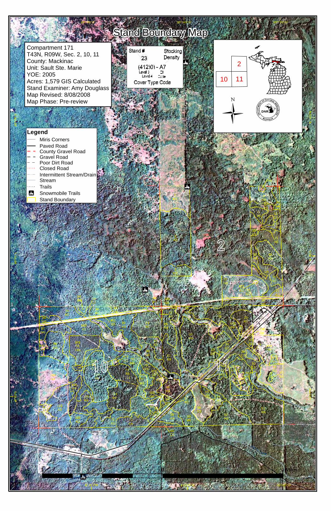
SAULT FOREST MANAGEMENT UNIT COMPARTMENT REVIEW PRESENTATION COMPARTMENT # 171 ENTRY YEAR: 2005 Compartment Acreage: 1579 County: Mackinac Revision Date: July 7, 2003; undated July 18, 2008 for Red Pine Project Stand Examiner: Amy Douglass; updated by Amy Douglass for Joe Durbin Legal Description: T43N-R9W Sections 2, 10 & 11; Garfield Township RMU (if applicable): Management Goals: This compartment is located around the burg of Gilchrist, approximately 5 miles northeast of Naubinway, and 4 miles west of Garnet. Much of this pine compartment was planted during the CCC days. Red pine was planted primarily, with some areas of mixed red pine, white pine and jack pine. Years planted: 1931, 1932, 1935 and 1937. A few of those acres have been clearcut and replanted to red pine in 1998 and 2000. A few of those acres have also been converted to aspen due to the partial failure of the original planting. Some plantations have been designated for final harvest and replanting to red pine in 2005, to distribute the age class within the red pine types. There is also a 15 acre red pine trial area in which we have initiated a series of underburns to promote natural regeneration. In 2005, other stands are being considered for natural regeneration of red and white pine. Two spruce plantations from 1962 are within the compartment. They have received various attempts at TSI, but have not responded. One of these was originally slated for conversion to red pine in 2005, but sale prep work determined that aspen would be a better management objective. The aspen within the compartment shows good age class diversity: one stand was kg’d by Wildlife Division in 1973, several stands cut in the mid to late 1980’s (’84 – ’89), and several stands cut through the 1990’s (’91 – ’98). The goals of the Red Pine Project (RPP) include increasing the available fiber supply of red pine for forest products and adjusting/balancing the red pine cover-type age-class distribution by harvesting red pine timber stands in the 40-79 year age-classes and regenerating areas to red pine. In this compartment, management treatments for the RPP will be in section 10. Stand 74, 101 and 102 will be final harvested and planted to red pine. Stand 101 is the second spruce plantation mentioned within the compartment. This is slated for conversion to red pine as part of this project. Soil and Topography: The majority of the compartment is composed of nearly level and undulating areas on outwash plains and lake plains, with some gently rolling and rolling areas to very steep areas. Associated soils within this area are Wallace sand, Paquin sand, Paquin-Spot complex, and Paquin-Finch sands. The majority of Section 2 is composed of the ridge and swale complex on outwash plains and lake plains, with Wallace-Spot complex as the major soil type. The depressions and nearly level areas on lake plains and outwash plains consist of Markey-Spot-Finch complex. Ownership Patterns, Development, and Land Use in and Around the Compartment: State lands adjoin the compartment to the south, east and north. The Hiawatha Sportsman’s Club (35,000 acres) abuts to the west. Land use is similar within the Hiawatha Sportsman’s Club, with timber/game management and hunting being primary adjacent to this compartment. The 320 acres of private land within Section 2 is held by just 3 separate landowners, as hunting camps primarily. The burg of Gilchrist occupies the NENE of Section 11. Compartment 171 Page 1 of 3
Transcript
SAULT FOREST MANAGEMENT UNIT
COMPARTMENT REVIEW PRESENTATION
COMPARTMENT # 171 ENTRY YEAR: 2005
Compartment Acreage: 1579 County: Mackinac Revision Date: July 7, 2003; undated July 18, 2008 for Red Pine Project Stand Examiner: Amy Douglass; updated by Amy Douglass for Joe Durbin Legal Description: T43N-R9W Sections 2, 10 & 11; Garfield Township RMU (if applicable): Management Goals: This compartment is located around the burg of Gilchrist, approximately 5 miles northeast of Naubinway, and 4 miles west of Garnet. Much of this pine compartment was planted during the CCC days. Red pine was planted primarily, with some areas of mixed red pine, white pine and jack pine. Years planted: 1931, 1932, 1935 and 1937. A few of those acres have been clearcut and replanted to red pine in 1998 and 2000. A few of those acres have also been converted to aspen due to the partial failure of the original planting. Some plantations have been designated for final harvest and replanting to red pine in 2005, to distribute the age class within the red pine types. There is also a 15 acre red pine trial area in which we have initiated a series of underburns to promote natural regeneration. In 2005, other stands are being considered for natural regeneration of red and white pine. Two spruce plantations from 1962 are within the compartment. They have received various attempts at TSI, but have not responded. One of these was originally slated for conversion to red pine in 2005, but sale prep work determined that aspen would be a better management objective. The aspen within the compartment shows good age class diversity: one stand was kg’d by Wildlife Division in 1973, several stands cut in the mid to late 1980’s (’84 – ’89), and several stands cut through the 1990’s (’91 – ’98). The goals of the Red Pine Project (RPP) include increasing the available fiber supply of red pine for forest products and adjusting/balancing the red pine cover-type age-class distribution by harvesting red pine timber stands in the 40-79 year age-classes and regenerating areas to red pine. In this compartment, management treatments for the RPP will be in section 10. Stand 74, 101 and 102 will be final harvested and planted to red pine. Stand 101 is the second spruce plantation mentioned within the compartment. This is slated for conversion to red pine as part of this project. Soil and Topography: The majority of the compartment is composed of nearly level and undulating areas on outwash plains and lake plains, with some gently rolling and rolling areas to very steep areas. Associated soils within this area are Wallace sand, Paquin sand, Paquin-Spot complex, and Paquin-Finch sands. The majority of Section 2 is composed of the ridge and swale complex on outwash plains and lake plains, with Wallace-Spot complex as the major soil type. The depressions and nearly level areas on lake plains and outwash plains consist of Markey-Spot-Finch complex. Ownership Patterns, Development, and Land Use in and Around the Compartment: State lands adjoin the compartment to the south, east and north. The Hiawatha Sportsman’s Club (35,000 acres) abuts to the west. Land use is similar within the Hiawatha Sportsman’s Club, with timber/game management and hunting being primary adjacent to this compartment. The 320 acres of private land within Section 2 is held by just 3 separate landowners, as hunting camps primarily. The burg of Gilchrist occupies the NENE of Section 11. Compartment 171 Page 1 of 3
Compartment 171 Page 2 of 3
Gilchrist consists of permanent and seasonal residences and camps. Peter’s Creek Ski Trail was developed after the last review. A State Police radio tower site, constructed in 1999, resides in the SESE of Section 10. Unique, Natural Features (include only non-site specific and non-sensitive information): The headwaters of Peter’s Creek and Kinny Creek are located here. Archeological, Historical, and Cultural Features (include only non-site specific and non-sensitive information): Old logging camps are located within the compartment. The old Township dump was located in Section 11. Gilchrist Fire Tower was located on a knob in Section 10. Hiawatha Sportsman’s Club (35,000 acres) is located to the west of the compartment. Notable differences in prior management are seen along this line. Most notable are where the CCC planted pine on state lands and the Hiawatha Club lands were not planted. Special Management Designations or Considerations: Planned harvesting activities should not be in conflict with the snowmobile trail. Stands north of the power line in Section 10 would be best harvested when the Hiawatha Club plans harvesting on their lands. The potential exists for red-shouldered hawks in this area. If active nests are found, appropriate buffers and harvest timing limitations will be placed. Watershed and Fisheries Considerations: Fisheries Values Poor. Kinney Creek is classified warm water (SQWW). However, it may support seasonal migrations of trout during spring or fall, and should still be protected from further sand erosion. Wildlife Habitat Considerations: This compartment lies within the St. Ignace sub-subsection. The growing season last approximately 130 days. Extreme winter low temperature approaches –460 F. Annual snowfall averages 80 inches. Pre-settlement vegetation generally consisted of northern hardwoods, hemlock-beech, and hemlock-white pine forests. Dry sandy areas were dominated by white pine, hemlock, red pine, and localized jack pine forests. Lowland conifer swamps featured northern white cedar, tamarack, balsam fir, and black spruce. Historically, natural disturbances have included wildfire, beaver flooding and wind throw. Current vegetation composition in the lowlands appears to be similar to the pre-settlement species composition. However, the upland portions of the compartment have been substantially altered. Red pine plantations dominate the central portion of the compartment. Aspen stands and grassy openings are also found on the uplands. Wildlife habitat management objectives include increasing the conifer component within aspen stands along the Kinney Creek, promoting age class diversity within the aspen and red pine forest community opening maintenance will be performed as needed. With the probable exception of gray wolves which likely travel through, there are no known occurrences of endangered, or threatened species within this compartment. However, sharp-tailed grouse, which are listed as special concern, are known to utilize this compartment. Moose (special concern) are also known to travel through this area occasionally. Examples of a few species that should benefit from the management regime in this compartment include leopard frog, red-backed salamander, saw-whet owl, ruffed grouse, American woodcock, red squirrel, and white-tailed deer. Mineral Resource and Development Concerns and/or Restrictions: Surface sediments consist of lacustrine (lake) sand and gravel. There is insufficient data to determine the glacial drift thickness. The
Compartment 171 Page 3 of 3
Silurian Engadine and Manistique Groups subcrop below the glacial drift. The Engadine is quarried for stone/limestone elsewhere in the UP. Gravel pits are not located in the compartment and potential may be limited. There is no economic oil and gas production in the UP. Vehicle Access: Access is good to the majority of the compartment. Hiawatha Trail, a paved county road, crosses Section 11. Cranberry Lake Road, a sand county road, runs north off Hiawatha Trail. Other maintained DNR roads include Gilchrist Tower Road, North Beach Road and Peter’s Creek Truck Trail. Several two track roads access other areas of the compartment. Survey Needs: None needed. Recreational Facilities and Opportunities: Snowmobile trail number 2 runs north along the North Beach Road to Gilchrist Tower Road to Cranberry Lake Road. This is the main trail from Naubinway to the Newberry/Rexton cut off. Peter’s Creek Ski Trail was established in 1994. It was put in and is maintained by volunteers. Funding has been granted for disking and seeding the trail in 2003. The area is also used for grouse, woodcock, hare, deer and bear hunting. Fishing opportunities may exist in parts of Kinny and Peter’s Creeks. Mushroom, berry picking, trapping and nature viewing opportunities exist within the compartment. Fire Protection: While the opportunity exists for wildfires within the compartment, none have been noted in recent years. Section 2 is within the southern boundary of one of the zone dispatch areas within the Naubinway Area. Certainly the fuel types (pine) within the compartment are conducive to wildfires and the potential exists for a fire start in the areas adjacent to the zone dispatch area. However, this area is close to the Naubinway Office and has good vehicle access throughout most of the compartment. Access to the adjacent Hiawatha Club is through locked gates. However, access is obtainable. Additional Compartment Information: An 800 megahertz State Police radio tower was erected in the SESE of Section 10 in 1999. The easement involves an 8 acre parcel of land.
The following 5 reports from the Operations Inventory System (OIPC) are attached: ♦ Cover Type by Age Class ♦ Cover Type by Management Objective ♦ Compartment Volume Summary ♦ Proposed Treatments – No Limiting Factors ♦ Proposed Treatments – With Limiting Factors
The following information is displayed, where pertinent, on the attached compartment maps: ♦ Base feature information, stand numbers, cover types ♦ Proposed treatments ♦ Proposed road access system ♦ Suggested potential old growth
StandCoverType Acres Age
SiteIndex
MgtObj Condition
MethodCut
HarvestPriority
CulturalNeed
FDFStatus
SAULT STE. MARIE MGT. UNIT Compartment: 171* RED PINE PROJECT * PROPOSED TREATMENTS
Entry Year: 2005
74 R9 18 73 65 immature final harvest 1 plantingred pine
Thinned 1997, 1980. Some variability in residual BA. Large remnant WP within stand. 7/2008: For the Red Pine Project (phase 2) this stand is scheduled for final harvest, site prep as necessary, trench and plant to red pine. This portion was broken off from the old stand 74 (47 acres), with the new stand 174 being retained for future management.
Fmd :comnts
101 F6 26 46 60 immature final harvest 1 plantingred pine
Spruce plantation. Very limby and variable size. Rows fairly visible, approx. 8' apart. Has had some release attempts, and sustained budworm damage earlier. 7/2008: For the Red Pine Project (phase 2), this stand is scheduled for final harvest, site prep as necessary, trench and plant to red pine.
Fmd :comnts
102 R9 2 73 64 immature final harvest 1 plantingred pine
Thinned 1998 (cut all but RP), thinned 1985 (cut all but RP and JP). 7/2008: For the Red Pine Project (phase 2), this stand is scheduled for final harvest, site prep as necessary, trench and plant to red pine.
Fmd :comnts
46Total Acres.......
Page 1 of 1 8/19/2008
80L0
2A3
51R9
31R8
100A3
22A3
73A3
17Q5
103M6
28R8
108A3
84F6
1R3
109A3
90A3
52R8
48R3
99A6 446
G038C6
58M6
18A5
56R3
174R9
43A6
76M6
95A3
85R8
78R9
81R9
8A3
104R9
14V0
97W6
34C6
59A3
11B5
41A3
92B6
106R9
30N0
68X0
105A3
63R8
50L0
72Q5
29R9
82A3
3M6
54N0
32L0
61X0
491G0
89M6
20V0
9M6
47A3
37R9
26V0
13Q5
10V0
77M3
445G0
71B6
39L0
410G0
425G0
96W6
55R9
60Q5
93L0
21L0
498G0
44W4
64R8
88V0
19A5
435G0 436
G0
94B6 486
G0
16A5
33B6
15A5
479G0
7V0
49L0
87A3
66A3
475G0
465G0
423G0
101F6116
74R9116
102R9116
Peters Creek
East Mile Creek
Hiawath
a Trl
Cra
nber
ry L
ake
Rd
Peters Creek R
d
No
Nam
e R
d
Bea
ch R
d
Lowen
St
Hiawatha Trl
85°25’0"W
85°25’0"W
85°24’0"W
85°24’0"W
85°23’0"W
85°23’0"W46
°8’0
"N
46°8
’0"N
46°9
’0"N
46°9
’0"N
46°1
0’0"
N
46°1
0’0"
N
Cover Type & Treatment Map
LegendMiris CornersPaved RoadCounty Gravel RoadGravel RoadPoor Dirt RoadClosed RoadRailroadsTrailsIntermittent Stream/DrainStreamLakes and Rivers AllSnowmobile TrailsStand Boundary116 - Final Harvest/PlantingA - AspenB - BirchC - Northern White CedarF - Upland Spruce or FirG - GrassL - Lowland BrushM - Northern HardwoodsN - MarshQ - Mixed Swamp ConiferR - Red PineV - Bog or MuskegW - White PineX- Non-Stocked
* This is a list of Dedicated Biodiversity Areas for this compartment along with a 1/4 mile buffer surrounding the compartment. Refer to Dedicated Conservation Area Map for areas that the below listed Conservation Areas are located.
DEDICATED CONSERVATION AREA DETAILS
Conservation Area SCA = Special Conservation Area
HCVA = High Conservation Value AreaERA = Ecological Reference Area
An aquatic or terrestrial area of the State that contains physical remains of human occupation. These are sites of cultural and historical significance that may occur upon terrestrial areas and Great Lakes bottomlands. They include thousands of Native American settlements and burial sites, as well as French and British outposts, nineteenth century logging camps, mines and homesteads. Beneath the waters of the Great Lakes, there are shipwrecks and other remains documenting the maritime trade. Such sites may be identified by Natural heritage data from the State Historic Preservation Office. Proposed treatments in this compartment will be implemented in such a manner as to maintain the integrity of these sites. Due to the sensitive nature of this information, no further detail about location is available.
Archaeological Site
SCA
A coldwater stream has temperature and dissolved oxygen conditions that allow naturally-reproduced or stocked trout populations and those of other coldwater fish species (e.g., slimy sculpin) to persist from year to year. Coldwater streams in Michigan typically provide these conditions due to substantial contributions of groundwater to their stream flows. Such streams are established by Director's action and designated as trout resources by Fisheries Order 210.