11
Bay of Bengal Oil Blocks Sunken Lands Speak Dangers Ahead A REPORT TO TAMILNADU GOVERNMENT ON INTERLINKING OF RIVERS IN CHANGED GEO- POLITICAL SCENARIO by N.Nandhivarman
| Date post: | 07-Apr-2018 |
| Category: |
Documents |
| Upload: | nandhi-varman |
| View: | 221 times |
| Download: | 0 times |
8/6/2019 Save Seas & River Basins
http://slidepdf.com/reader/full/save-seas-river-basins 1/11
Bay of Bengal Oil Blocks
Sunken Lands Speak Dangers Ahead
A REPORT TO TAMILNADU GOVERNMENT
ON INTERLINKING OF RIVERS IN CHANGED GEO-POLITICAL SCENARIO by N.Nandhivarman
8/6/2019 Save Seas & River Basins
http://slidepdf.com/reader/full/save-seas-river-basins 2/11
53-b,Calve Subburayar Street, Puducherry 605001 India
Tel: +91-413-2221025web: www.dravidaperavai.org.in email: [email protected]
Hon’ble Tamilnadu Chief Minister Dr.J.Jayalalithaa 7.6.2011
Government of Tamilnadu
Respected Madam
Subject : Interlinking of Rivers in changed geo-political scenario..
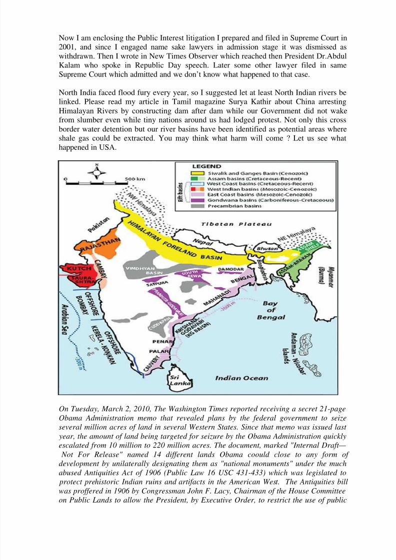
British could interlink India with Rail link, but now the UN project to interlink all
continents through rail link remains a dream. In Bering Straits a land bridge would have
linked all continents. In India too we have been toying with a rail link from Vietnam to
London through Delhi of course this UN dream project had made news when Lallu Prasad
was Railway Minister. Like these dream projects in India we have been talking about
interlinking of rivers. If Government of India had initiated this project when K.L.Raomooted now we could have boosted our agrarian economy. Chaudry Charan Singh who asPrime Minister accommodated 2 from Anna DMK in his cabinet was for giving preference
and predominance to agriculture but his term was shortest.
8/6/2019 Save Seas & River Basins
http://slidepdf.com/reader/full/save-seas-river-basins 3/11
Now I am enclosing the Public Interest litigation I prepared and filed in Supreme Court in
2001, and since I engaged name sake lawyers in admission stage it was dismissed as
withdrawn. Then I wrote in New Times Observer which reached then President Dr.Abdul
Kalam who spoke in Republic Day speech. Later some other lawyer filed in same
Supreme Court which admitted and we don’t know what happened to that case.
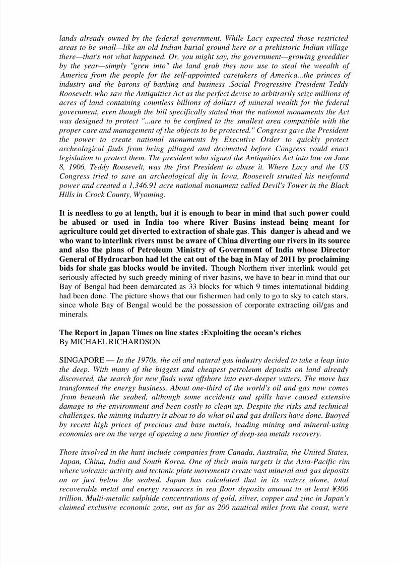
North India faced flood fury every year, so I suggested let at least North Indian rivers be
linked. Please read my article in Tamil magazine Surya Kathir about China arresting
Himalayan Rivers by constructing dam after dam while our Government did not wakefrom slumber even while tiny nations around us had lodged protest. Not only this cross
border water detention but our river basins have been identified as potential areas where
shale gas could be extracted. You may think what harm will come ? Let us see what
happened in USA.
On Tuesday, March 2, 2010, The Washington Times reported receiving a secret 21-pageObama Administration memo that revealed plans by the federal government to seizeseveral million acres of land in several Western States. Since that memo was issued last
year, the amount of land being targeted for seizure by the Obama Administration quicklyescalated from 10 million to 220 million acres. The document, marked "Internal Draft—
Not For Release" named 14 different lands Obama coould close to any form of development by unilaterally designating them as "national monuments" under the muchabused Antiquities Act of 1906 (Public Law 16 USC 431-433) which was legislated to
protect prehistoric Indian ruins and artifacts in the American West. The Antiquities bill
was proffered in 1906 by Congressman John F. Lacy, Chairman of the House Committeeon Public Lands to allow the President, by Executive Order, to restrict the use of public
8/6/2019 Save Seas & River Basins
http://slidepdf.com/reader/full/save-seas-river-basins 4/11
lands already owned by the federal government. While Lacy expected those restricted areas to be small—like an old Indian burial ground here or a prehistoric Indian villagethere—that's not what happened. Or, you might say, the government—growing greeddier by the year—simply "grew into" the land grab they now use to steal the weealth of
America from the people for the self-appointed caretakers of America...the princes of industry and the barons of banking and business .Social Progressive President Teddy
Roosevelt, who saw the Antiquities Act as the perfect devise to arbitrarily seize millions of acres of land containing countless billions of dollars of mineral wealth for the federalgovernment, even though the bill specifically stated that the national monuments the Act was designed to protect "...are to be confined to the smallest area compatible with the
proper care and management of the objects to be protected." Congress gave the President the power to create national monuments by Executive Order to quickly protect archeological finds from being pillaged and decimated before Congress could enact legislation to protect them. The president who signed the Antiquities Act into law on June8, 1906, Teddy Roosevelt, was the first President to abuse it. Where Lacy and the USCongress tried to save an archeological dig in Iowa, Roosevelt strutted his newfound
power and created a 1,346.91 acre national monument called Devil's Tower in the Black
Hills in Crock County, Wyoming.
It is needless to go at length, but it is enough to bear in mind that such power could
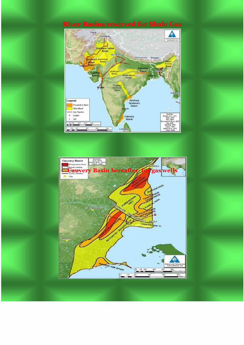
be abused or used in India too where River Basins instead being meant foragriculture could get diverted to extraction of shale gas. This danger is ahead and we
who want to interlink rivers must be aware of China diverting our rivers in its source
and also the plans of Petroleum Ministry of Government of India whose Director
General of Hydrocarbon had let the cat out of the bag in May of 2011 by proclaimingbids for shale gas blocks would be invited. Though Northern river interlink would get
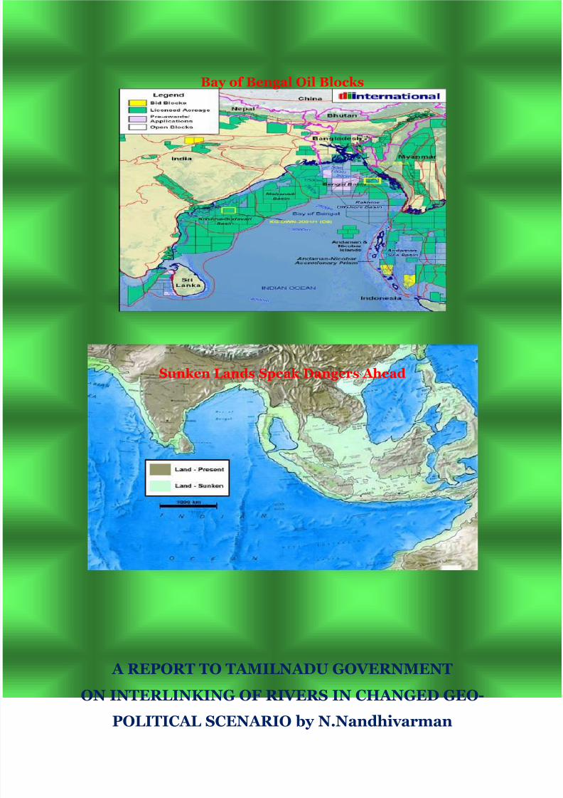
seriously affected by such greedy mining of river basins, we have to bear in mind that our
Bay of Bengal had been demarcated as 33 blocks for which 9 times international bidding
had been done. The picture shows that our fishermen had only to go to sky to catch stars,since whole Bay of Bengal would be the possession of corporate extracting oil/gas and
minerals.
The Report in Japan Times on line states :Exploiting the ocean's riches
By MICHAEL RICHARDSON
SINGAPORE — In the 1970s, the oil and natural gas industry decided to take a leap intothe deep. With many of the biggest and cheapest petroleum deposits on land alreadydiscovered, the search for new finds went offshore into ever-deeper waters. The move hastransformed the energy business. About one-third of the world's oil and gas now comes
from beneath the seabed, although some accidents and spills have caused extensivedamage to the environment and been costly to clean up. Despite the risks and technicalchallenges, the mining industry is about to do what oil and gas drillers have done. Buoyed by recent high prices of precious and base metals, leading mining and mineral-usingeconomies are on the verge of opening a new frontier of deep-sea metals recovery.
Those involved in the hunt include companies from Canada, Australia, the United States, Japan, China, India and South Korea. One of their main targets is the Asia-Pacific rimwhere volcanic activity and tectonic plate movements create vast mineral and gas depositson or just below the seabed. Japan has calculated that in its waters alone, totalrecoverable metal and energy resources in sea floor deposits amount to at least ¥300
trillion. Multi-metalic sulphide concentrations of gold, silver, copper and zinc in Japan'sclaimed exclusive economic zone, out as far as 200 nautical miles from the coast, were
8/6/2019 Save Seas & River Basins
http://slidepdf.com/reader/full/save-seas-river-basins 5/11
estimated to be worth ¥80 trillion in late 2008, when most commodity prices weredepressed by the financial crisis.Cobalt-rich crusts containing titanium, manganese,nickel and platinum as well as cobalt are valued at ¥100 trillion, while reserves of methanehydrate, icelike gas formations trapped in sediment on the seabed, are put at ¥120trillion.State-owned China Minmetals, the country's largest metals trader, is intensifyingresearch and development into deep-sea mining. Noting that China relied heavily oncostly raw-material imports, Minmetals president, Zhou Zhongshu, said in March that "this will push the country to go for deep-sea mining to explore (for) metals includingcopper, nickel, silver and gold."
No one has yet attempted full-scale commercial mining to exploit the trove of seabed mineral riches. But earlier this year, the Papua New Guinea government granted theworld's first deep-sea mining lease to Nautilus Minerals Inc, a Canadian-based firmbacked by several multinational and Russian mining groups.
Nautilus is assembling a combination of proven technologies from different industries,among them mining, oil and gas, and dredging, to create what it says will be a cost-
efficient system for deep-sea mining. In 2013, it plans to start mining a high-grade copper-gold resource about 1,600 meters below the surface of the Bismarck Sea in Papua NewGuinea waters.The company says it will use remotely operated undersea vehicles and machines to cut ore from the sea floor and pump it up to a production support vessel onthe surface as seawater slurry. The water will then be removed and the ore shipped toshore for smelting into ingots. After investing about $400 million, Nautilus aims to
produce ore at an annual rate of more than 1.3 million tons, containing approximately80,000 tons of copper and up to 200,000 ounces of gold for a number of years beforeshifting its moveable production system to other nearby deposits it has found. Multi-metallic sulphides are found around seabed hot springs emerging from volcanic vents.Seawater percolates down through the crust and reacts chemically with the rocks at very
high temperatures, collecting metals as it does so. When the hot vent water rises and mixeswith the cold seawater on the ocean floor, the metals precipitate out to form concentrated deposits. Exploiting these deposits in national waters is already controversial. After returning from a recent visit to Papua New Guinea, Australia's Greens party leader, Sen.
Bob Brown, said he would seek a Senate inquire into the environmental impact of undersea mining.
Other critics say that the Asia-Pacific rim is being made a test bed for a potentially
damaging new form of mining as technology races ahead of regulation.
Another Canadian-based company, DeepGreen Resources Inc., is seeking financial
backing to mine a massive copper-nickel deposit in international waters in the PacificOcean between Hawaii and Mexico. The deposit lies 4,500 meters below the surface of thesea.
Meanwhile , China and India have filed applications with the United Nations
International Seabed Authority (ISA) for high seas mining rights of the Indian Ocean. The ISA has regulatory authority over seabed mineral resources in international waters.
Its mandate is to ensure that these resources are exploited in a way that is fair to allcountries. However, it has yet to spell out whether and to what extent conservation is part of the common heritage of mankind. [Michael Richardson is a visiting senior researchfellow at the Institute of Southeast Asian Studies in Singapore.]
8/6/2019 Save Seas & River Basins
http://slidepdf.com/reader/full/save-seas-river-basins 6/11
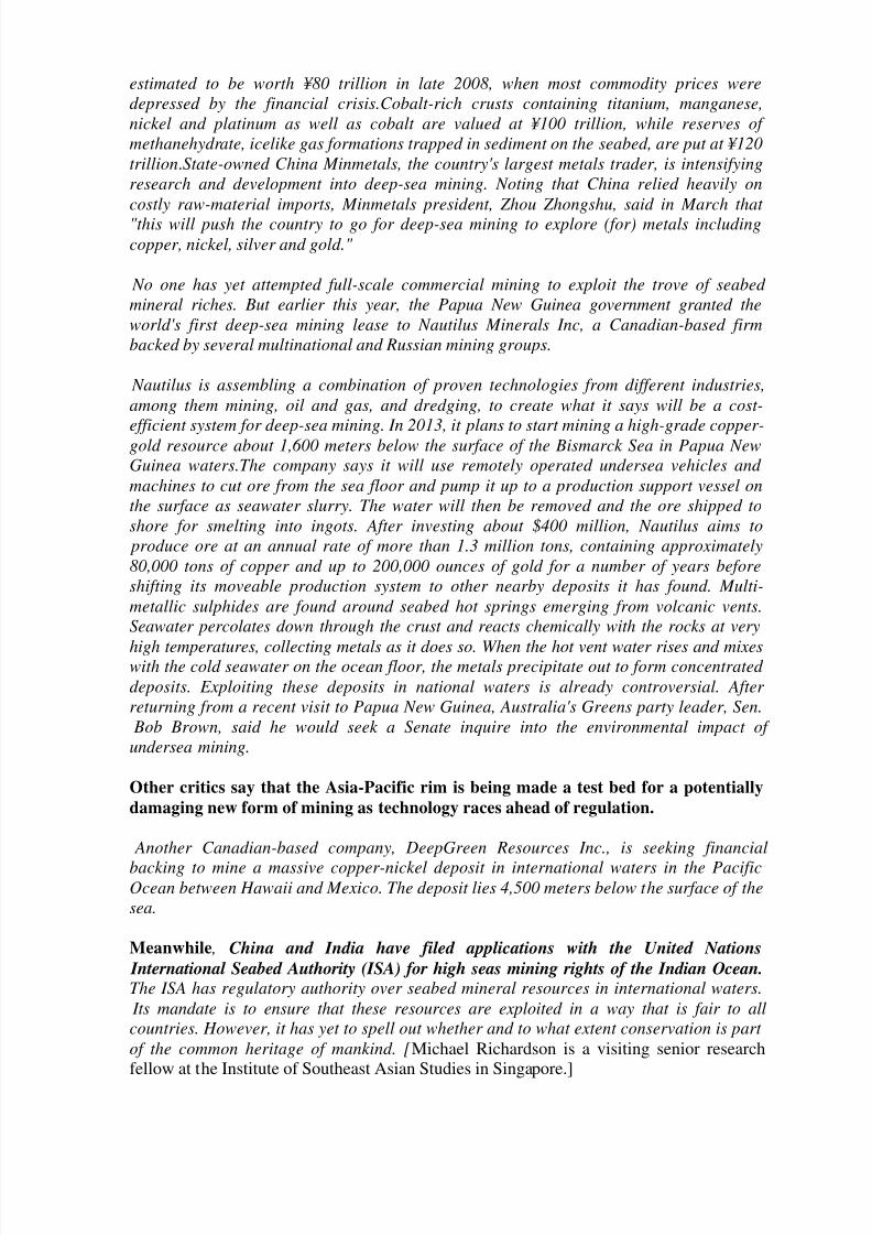
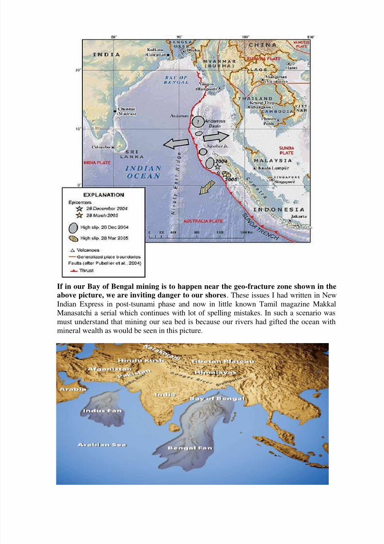
If in our Bay of Bengal mining is to happen near the geo-fracture zone shown in theabove picture, we are inviting danger to our shores. These issues I had written in New
Indian Express in post-tsunami phase and now in little known Tamil magazine Makkal
Manasatchi a serial which continues with lot of spelling mistakes. In such a scenario was
must understand that mining our sea bed is because our rivers had gifted the ocean with
mineral wealth as would be seen in this picture.
8/6/2019 Save Seas & River Basins
http://slidepdf.com/reader/full/save-seas-river-basins 7/11
This Large Marine Ecosystem (LME) is characterized by its tropical climate. It is situated in the monsoon belt and receives high rainfall. Bangladesh, India, Indonesia, Malaysia,
Maldives, Myanmar, Sri Lanka, and Thailand are the countries bordering the LME. Intensive fishing is the primary force driving the LME, with climate as the secondarydriving force. The Global Environment Facility (GEF) is supporting a fisheries project,now in the preparation stage, to address critical threats to the coastal and marineenvironment, and to promote ecosystem-based management of coastal and marineresources. LME book chapters and articles pertaining to the Bay of Bengal LME include
Dwivedi, 1993, and Aziz Ahmad et al, 1998.
Productivity :For a description of the Bay of Bengal as a shared ecosystem, see Aziz Ahmad et al, 1998. The LME is affected by monsoons, storm surges, and cyclones but hasno seasonal upwelling. However, in nearshore areas, the mixing of nutrient rich bottomwaters and warm surface waters creates conditions similar to upwelling (see Dwivedi and Choubey, 1998). The number and intensity of cyclones in the northern part of the Bay of
Bengal are likely to increase due to global warming. For more on the southwest monsoon,see Desai and Bhargava, 1998. Major rivers such as the Brahmaputra and Ganges
discharge large quantities of fresh water into the Bay of Bengal (see Dwivedi and Choubey, 1998). For a map of freshwater drainage of the Northern Bay of Bengal, see Dwivedi, 1993, p. 45. This input of freshwater and silt impacts the salinity of the coastaland estuarine waters as well as coastal circulation patterns. It influences and governs
LME dynamics during the southwest monsoon. For more information on hydrography and productivity, see Dwivedi, 1993. Wetlands, marshes, and mangroves play an important role in the overall productivity. The Bay of Bengal LME is considered a Class II,moderately productive (150-300 grams of carbon per square meter per year) ecosystembased on SeaWiFS global primary productivity estimates. Changing environmentalconditions are influencing currents, productivity and coastal pollution. Lakes connected tothe Bay of Bengal LME are changing. Some coastal areas serving as nursery grounds for
commercially valuable species of prawns are polluted. For a map of distribution of zooplankton biomass in the Bay of Bengal LME, see Desai and Bhargava, 1998, p. 303.For more information on biological production and fishery potentials in India’s EEZ, see
Desai and Bhargava, 1998. For benthic biomass production in the shelf region of the Bayof Bengal, see Parulekar et al, 1982. A graph is reproduced on page 303 of Desai and
Bhargava, 1998. Six areas of critical biological diversity are: the Sundarbans, one of theworld’s most extensive mangrove systems, Palk Bay, the Gulf of Mannar, the Marine(Wandur) National Park in the Andaman and Nicobar Islands, the Maldives Atolls, Mu KoSimilan National Park and Mu Ko Surin National Park in Thailand.
Fish and Fisheries :The Food and Agriculture Organization (FAO) 10-year trend shows
a steady increase in catch from 1.4 million tons in 1990 to 2.2 million tons in 1999 (seeFAO, 2003). The average catch is 2 million tons. This tropical region has a relativelygreat marine biodiversity that is reflected in the catch composition. There is a high catch
percentage for miscellaneous coastal fishes and pelagic fishes (tuna, yellowfin, big eyeand skipjack). Herrings, sardines and anchovies represent more than 15% of the catch.The crustacean catch (shrimp is the major export earner) is just below 15% of the totalcatch (see FAO, 2003). Catch trends are quite diverse and it is difficult to identify a
pattern due to the fact there is inadequate information on the status of the fisheriesresources and their exploitation. For more information on the major fisheries in this LME,see Dwivedi, 1993. Despite a steady rise in total landings since the 1950s, there are signsthat the harvest levels may not be sustainable, especially with regard to tuna fishing in the
Maldives, Malaysia, Thailand’s Andaman coast and Sri Lanka. Ecological changes in the
8/6/2019 Save Seas & River Basins
http://slidepdf.com/reader/full/save-seas-river-basins 8/11
estuaries and coastal areas have not yet affected total production trends (see Dwivedi,1993).
The GEF-supported project is examining the issue of sustainable fisheries and food security. Heavy fishing through open access and the unauthorized incursions of foreign
fleets is a comparatively recent phenomenon. There is an increase of competition and conflicts between artisanal and large-scale fisherman. There is an alarming increase incyanide fishing in this LME’s coral reefs for the lucrative live food fish markets in HongKong and Singapore. Mangroves and estuaries--critical fish spawning and nursery areas-are also under stress or threatened by pollution, sedimentation, dams for flood control (asin Bangladesh), and intensive coastal aquaculture. In most of the countries surroundingthe Bay of Bengal, clear policies, appropriate strategies and measures for the sustainablemanagement of the fishery resources are weak. There is a need to establish a systematicdata collection system in order to prepare a regional strategy. The University of BritishColumbia has detailed fish catch statistics for this LME.
Pollution and Ecosystem Health
(Source: NOAA)The ecosystem stresses experienced are connected to the size of the coastal populationsbordering the LME (see Aziz Ahmad et al, 1998). Issues of ecosystem health that arecommon throughout the region are: environmental stresses on the Bay of Bengal’s water quality; the degradation of many of the coral, mangrove, wetland and seagrass bed habitats that support fisheries; and the use of fishing gear that may affect the long-termsustainability of the fisheries resource. For more information on anthropogenic changes,see Dwivedi, 1993. The major rivers bring in large concentrations of pollutants fromagricultural pesticides and industrial waste that damage fish spawning and nursery areas,cause fish kills and lead to possible changes in trophic structure. High levels of pesticidescan be found along the coast, especially near cities and ports (see Dwivedi, 1993). A
major part of Bangladesh consists of a delta plain positioned below the confluence of theGanga, Brahmaputra and Meghna Rivers. Environmental refugees regularly flee the
flooded plain, and many deaths occur with the floods. For a map of the effect of sea-levelrise on low-lying Bangladesh, see Dwivedi, 1993, p. 51. Sediment loading in the Ganga-
Brahmaputra watershed caused by accelerated soil erosion in the Himalayas isconsidered to be one of the main factors contributing to downstream flooding. In someregions of the Bay of Bengal, a change in composition of plankton species has beenobserved (see The Bay of Bengal Programme, 1994). There is heavy oil tanker trafficbetween Japan and the Middle East, with the main shipping route passing South of Sri
Lanka before entering the Straits of Malacca via a passage below the Nicobar Islands.For this reason, oil spills are a major concern. In 1993, India approved a national oil spill
contingency plan. There is inadequate information on pollution and sedimentation loadsentering the Bay of Bengal, on coastal habitats and endangered species. This informationis necessary in order to understand the functioning of the ecosystem and its reaction tostress over time.
Socio-economic Conditions
(Source: NOAA)
A quarter of the world's population resides in the countries bordering the Bay of Bengal Large Marine Ecosystem (see Aziz Ahmad et al, 1998). The high population depends oncoastal resources for food and livelihood security. India will soon reach a population of 1
billion. It will require millions of tons of fish to meet minimum protein needs. This putssignificant pressure on marine resources. There is an urgent need for long term planning
8/6/2019 Save Seas & River Basins
http://slidepdf.com/reader/full/save-seas-river-basins 9/11
for the conservation and management of the LME. Millions of tons of fish must come fromaquaculture. Of the 400 million people living in the LME's catchment area, many subsist at or below the poverty level. For more information on artisanal fisheries, see Dwivedi,1993. There are conflicts between large scale and small-scale fishermen. Poverty,unsustainable fishing practices and a decline in income from fisheries are contributing toa crisis. Addressing this crisis requires the coordinated effort of the 8 countries borderingthe LME. Other economic activities in the LME are tourism (for instance in the Maldives),and the mining of coral and sand for construction. The Global Environment Facility issupporting a project to protect the Bay of Bengal’s marine environment. The initiative ismobilizing national and regional efforts to improve the food and livelihood security of theregion’s coastal populations.
Governance
Bangladesh, India, Indonesia, Malaysia, Maldives, Myanmar, Sri Lanka, and Thailand arethe countries bordering the LME. A Project Description for The Bay of BengalProgramme is available. For a map showing EEZs in the Bay of Bengal, see Desai and
Bhargava, p. 298. There are numerous stakeholder groups involved in the fisheries of the Bay of Bengal (see Aziz Ahmad et al, 1998). For more information on policy frameworksin India, Sri Lanka, Indonesia, the Maldives and Malasia, and on the success of acommunity-based aquaculture enterprise in West Bengal, India, see Aziz Ahmad et al,1998. A multitude of international, regional and sub-regional institutions operate in the
Bay of Bengal, many of which have similar mandates, resulting in overlap and duplication. Fisheries organizations include the Indian Ocean Fisheries Commission(IOFC), the Indian Ocean Tuna Commission (IOTC), the International Forum for the
Indian Ocean (IFIOR), the Indian Ocean Rim Initiative, the Asia-Pacific FisheryCommission (APFIC), and the Network of Aquaculture Centres for Asia (NACA). The Bayof Bengal Program (BOBP) is a regional fisheries project executed by FAO. It became
operational in 1979 and involves all the countries bordering the Bay of Bengal with theexception of Myanmar. For more information on fisheries management and regulation,see the FAO web site. Other trans boundary areas are oil spill planning, legal and institutional review, and pollution control measures. On the whole, the region lacksenforcement capabilities. Major organizations of the area include the Association of South
East Asian Nations (ASEAN), the South Asian Association for Regional Co-operation(SAARC), the United Nations Economic and Social Commission for Asia and the Pacific(ESCAP), the South Asian Co-operative Environment Programme (SACEP), the UNEP
Regional Co-ordinating Unit for East Asian Seas, and the Indian Ocean Marine AffairsCo-operation (IOMAC).
Fisheries and Agriculture should be Tamilnadu Governments twin areas of thrust.Hence necessity arises on not only interlinking our rivers but also saving our coast
from sea level rise. A Report by IIT-Chennai published in Times of India throws
more light on saving our coast. Saving our Sea and River Basin had become
imperative with corporate sharks encircling India after International Sea Bed
Authority of UN had focused on mining in seabed. Chinese encirclement of India
planned three decades ago too is aimed at looting the mineral wealth in our seas.
Hence on interlinking of rivers I would add the Sagar Mala scheme announced by Atal
Bihari Vajpayee. It was mooted by me. To divert cargo and passenger traffic from road tosea lanes, I urged for creation of National Sea ways on the lines of National High Ways. It
was intended to reduce lorry traffic in roads and to use then existing 12 major ports and
138 minor and intermediary ports for inland cargo and passenger traffic. But now 180
8/6/2019 Save Seas & River Basins
http://slidepdf.com/reader/full/save-seas-river-basins 10/11
ports captive ports under private hands are planned every 30 kilometer not for the purpose
I speak but to use them for oil-mineral exploitation from our seas depriving fishermen of
livelihood, and turning the rice bowl of Tamilnadu into an oil tanker of Tamilnadu.
Interlinking rivers is meant for boosting agriculture but vultures hover around to
make our river basins as gas and oil fields. For Water we have to go to Moon and For
power too moon is our savior as enclosed Times of India report says. But where to
produce food and for which how to interlink our rivers is an area over which political
leaders like you who have will must engage in brainstorming sessions.
With Regards
Yours fraternally
N.Nandhivarman General Secretary Dravida Peravai
www.dravidaperavai.org.in
8/6/2019 Save Seas & River Basins
http://slidepdf.com/reader/full/save-seas-river-basins 11/11
River Basins reserved for Shale Gas
Cauvery Basin hereafter for gas wells


![Untitled-2 []...Eben Coffin4 Eben Coffin John Darling7 paul Painter Bell Coffin John Darling King Grounds South Seas South Seas South Seas South Seas Brazil South Seas Production 550](https://static.documents.pub/doc/80x56/60e8bb276bd41c47e12f2272/untitled-2-eben-coffin4-eben-coffin-john-darling7-paul-painter-bell-coffin.jpg)
