52
, SAXON COAL LIMITED 1936 EXPLORATION REPDRT Coal $i(&ces: 2763 - 2812 ;;N.T.S:keWence: 9311 - 9318 , Qperator: &i$son Coal Limited /42-4~u~ 74 Cl)&-. G&f Jar&n Jan~#ary, 1377

,
SAXON COAL LIMITED
1936 EXPLORATION REPDRT
Coal $i(&ces: 2763 - 2812 ;;N.T.S:keWence: 9311 - 9318 ,
Qperator: &i$son Coal Limited
/42-4~u~ 74 Cl)&-.
G&f Jar&n Jan~#ary, 1377
Within this report International System (S.I.) weights and
measures have been used throughout. British standards
together with S.I. units have been stated in some instances
for comparative purposes. Similarly, all maps and diagrams
are prepared according to S.I. standards, except that
degrees of dip rather than grads are used on geological maps.

y-.. STATEMENT OF QUALIFICATIONS
..,
I, Geoffrey Robert Jordan, having completed a science degree
course, majoring in geology, at the University of New South Wales,
Sydney, Australia, at the beginning of 1971, have been engaged in
coal exploration from that time to the present.
During this period I have carried out these investigations in
Canada, Asia and Australia for several mining and geological consulting
companies. This work has involved exploration on coal properties in
British Columbia during the 1971, 1972, 1973, 1975 and 1976 field
seasons and has included various forms of data collection, interpreta-
tion, project supervision and reporting to several private and
governmental bodies.
I have been employed as a project geologist by Denison Coal
Limited since March of 1975, principally responsible for exploration
activities carried out on the Saxon coal properties.
The exploration project carried out by Denison Coal Limited
on the Saxon property during the summer program of 1976 undertaken
in the field, and the interpretation of data made off the property,
came under my direct supervision.
rdan, P. Geol.
.
TABLE OF CONTENTS
1.0 SUMMARY
2.0 INTRODUCTION
3.0 PROPERTY, LOCATION AND ACCESS
4.0 SUMMARY OF EXPLORATION
5.0 STRATIGRAPHY
6..0 STRUCTURE
7.0 RESERVES
8.0 COAL QUALITY AND COKE TESTING
9.0 CONCLUSION
10.0 EXPLORATION PROGRAM PERSONNEL
LIST OF TABLES AND APPENDICES
PAGE NUMBER
TABLE NO.1 STRATIGRAPHY - TABLE OF FORMATIONS
TABLE NO.2 RESERVES BY MINING DISTRICT
TABLE NO.3 SAXON EAST INDICATED RESERVES
TABLE NO.4 SAXON EAST INFERRED RESERVES
TABLE NO.5 SAXON WEST INFERRED RESERVES
TABLE No.6 SAXON SOUTH INDICATED RESERVES
TABLE~No.7 COAL QUALITY DATA - DRILL CORE SAMPLES
TABLE No.8 COAL QUALITY DATA - ADIT DATA
.d APPENDIX I GRAPHIC DRILL LOGS
$' PPENDIX II GRAPHIC TRENCH LOGS
d PPENDIX III CURRENT SCHEDULE OF COAL LICENSES - \N -km
&APPENDIX Iv RESERVE CALCULATIONS AND METHODS
APPENDIX v ANALYSIS 0~ DRILL LOGS AND ADITS
.@(PPEf4i3IX VI METHODS AND PROCEDURES OF AERIAL PHOTOGRAPHY SURVEY

dl PPENDIX VII
APPENDIX VIII
APPENDIX IX
J APPENDIX X
J APPENDIX XI
FIGURE 1.
FIGURE 2.
FIGURE 3.
FIGURE 4.
FIGURE 5.
FIGURE 6.
FIGURE 7.
TABLE OF CONTENTS
PRELIMINARY TERRAIN CLASSI,FICATION
OF THE SAXON AREA
COAL QUALITY DATA &&rb csnF;deAh Cod ++-$'s 'Ifrz
ADIT WASHABILITY TESTS
GEOPHYSICAL LOGS
CORE DESCRIPTION LOGS
LIST OF TEXT MAPS AND FIGURES
LOCATION MAP -, IN TEXT
SAXON COAL LICENSES - IN TEXT
SAXON STRUCTURAL AREAS - IN TEXT
GENERALISED STRATIGRAPHIC COLUMN, GATES MEMBER - IN TEXT
GENERALISED CROSS SECTION - IN TEXT
SAXON RESERVE AREAS - IN TEXT
PROCEDURE FOR ANALYSIS OF COAL CORE SAMPLES - IN TEXT
TABLET OF CONTENTS
: ’ .t.IsT~ OF~TEXT MAPS AND FIGURES
FIGURE 1. LOCATION MAP - IN TEXT
FIGURE 2. SAXON COAL ,LICENSES - IN TEXT
FIGURE ~3. SAXON STRUCTURAL AREAS - IN TEXT
-FIGURE 4. GENERALISED STRATIGRAPHIC COLUMN, GATES MEMBER - IN TEXT
FIGURE 5. GENERALISED CROSS SECTION - IN TEXT
FIGURE 6. SAXON RESERVE AREAS - IN TEXT
FIGURE 7. PROCEDURE FOR ANALYSIS OF COAL CORE SAMPLES - IN TEXT

TABLE OF CONTENTS
DRAWING NO. LIST OF ENCLOSED MAPS
SXON.75-0616-R02 GEOLOGICAL COMPILATION MAP, 1:25 000 - ENCLOSED,
SXON.75-0616-R02 I/~GEOLOGICAL COMPILATION MAP, 1:50 000 - ENCLOSED
SXON.76~0700-ROl @AXON SOUTH GEOLOGY - ENCLOSE!
sxoN.76-0706-~01 dsAx0~ GEOLOGY MAPS, 1:5 000 (5) - ENCLOSED
~~x0~.76-0685-~01~~~~0~ SOUTH STRUCTURE CONTOUR MAPS - ENCLOSED
SXON.76-0717-R013(SAXON EAST STRUCTURE CONTOUR MAPS-SOUTH BLOCK - ENCLOSED
SXON.76-0717-R01~ySAXON EAST STRUCTURE CONTOUR MAPS-NORTH BLOCK - ENCLOSED
SXON.76-0721-ROl J( SAXON WEST STRUCTURE CONTOUR MAPS - ENCLOSED
sxoN.76-0689-Rol &SAXON SOUTH CROSS SECTIONS, 1:5 000 - ENCLOSED
SXON.76-0689-ROl d SAXON EAST AND WEST CROSS SECTIONS 1:5 000 '- EN&&ED
SXON.76-0722-ROl $ SAXON SOUTH RESERVE MAPS, 1:5 000 - ENCLOSED
sxoN.76-0723-Rol J(SAXON EAST RESERVE AND SEAM THICKNESS MAPs,l:25 000 - ENCLOSED
sxoN.76-0724-Rol IYSAXON WEST RESERVE AND SEAM THICKNESS MAps,l:25 000 - ENCLOSED
SXON.76-0725-ROl SAXON SOUTH MINING SECTION ISOPACH M4PS, 1:5 000 - ENCLOSED
SXON.76-0725-ROl h! SAXON SOUTH IN SEAM DILUTION ISOPACH MAPS,1:5 000 - ENCLOSED
SXON.76-0704-ROl A
v4
AXON SOUTH MEASURED SECTION - ENCLOSED
SXON.76-0713-ROl AXON ADIT PLANS - 1.~ - ENCLOSED
sxoN.76-0727-~01 dsAx0~ SOUTH TRENCH LOCATION' MAP - ENCLOSED
sxoN.76-0726-~01 ~SAX~N EXPLORATION PROGRAM MAP - ENCLOSED
sxoN.76-0698-Rol /SAXON STRATIGRAPHIC CORRELATION MAP - ENCLOSED
SXON.76-0703-ROlldSAXON SEAM CORRELATION CHARTS - TRENCHES - ENCLOSED
SXON.76-0702-RO+AXON SEAM CORRELATION CHARTS - DRILL HOLES - ENCLOSED
and
SXON.76-0701-ROl A.

1.0 SUMMARY
The Saxon property is located in the Province of British
Columbia along the Rocky Mountain foothills coal belt from which
all Westerh Canadian coking coal is produced. The property
consists of 135.9 square kilometers of coal licenses situated
just west of the border between the provinces of British-Columbia
and Alberta. The valley of the Narraway River, a major water
course, cuts through the centre~of the property and provides'
possible mine and plant sites and a potential transportation
corridor as well as access to the coal reserves. The property is
located approximately 153 kilometers from the Canadian National
Railway at Bend, B.C. and about 131 kilometers from Grande Prairie,
Alberta.
The following reserves have been outlined by exploration work
to date:
RESERVES IN PLACE
(millions metric tons)
SAXON EAST South of Narraway
(Indicated - includes
portion below drainage
to 500 metres cover)
North of Narraway
(Inferred - includes
portion below drainage
to 500 metres cover)
SAXON WEST Eastern portion
(Inferred - formerly
defined as part of
Saxon East; includes
portion below drainage
to 500 metres cover)
NET CLEAN
COAL
(milli;;;s~tric
162.1 57.4
73.3 25.9,’
25.3 9.0 - :-.

2.
-.. 3. SAXON SOUTH (Indicated - includes
-'all coal to 500 metres 165.4 ' ~ 73.7
cover, regardless of
proposed method of
extraction)
TOTAL INFERRED & INDICATED RESERVES 426.1 166.0
The table above includes coal reserves mineable by both surface
and underground methods. The portion of th~ese coal reserves mineable
by surface methods, which are located in the Saxon South area, are
tabulated below:
SURFACE MINEABLE RESERVES
Indicated in place
Net Clean Coal
SAXON SOUTH
(Millions Metric tons)
71.3
40.1
In addition to the above inferred and indicated reserves, the
portion of Saxon West, not included in the above reserve tables, is
considered to have an exploration potential-of about 220 million tonnes
of coal in place.
In Saxon East and Saxon West net clean coal has been calculated on
the basis of a 70% mining recovery for underground mining methods, an
85% geological confidence factor and a 70% preparation plant recovery
factor. A further factor of 85% was applied to allow for premature
termination of mining in any one district due to geological factors
such as small scale faultins. This gives an overall mining recovery of A;/c?&..
59.5%. These factors are applied where the mineable seams are in excess.mAz
of 3 metres thickness. In Saxon South net clean coal, for extensions to 3.rzf
the pit area have been calculated on the same basis, but in the surface kmLhp!&/
mining area a different set of parameters have been used which ~apply to
the different mininq method. For the area of surface mininq, plant feed
coal has been calculated by applying the following factors: 90% mining

recovery, 85% geological confidence factor, the addition of 5% by I
weight for "out-of-seam" dilution, and a 70% plant recovery factor 1 S-F/
which includes the plant efficiency was used to calculate net clean -2.6 3/- I !
coal. These calculations have been applied to the coal in place, "I' LCL f
which has been determined for seams Nos 1,2,3 and 4 where they are #h4i-..w"{
in excess of one metre thick and dipping less than 30' and where
they are in excess of 1.5 metres thick and dipping in excess of 30'.
For the surface mineable reserves a metric Plant Feed Ratio of 8.85/l. --- (cubic metres of overburden / metric ton of plant feed coal) has been
calculated.
Based on analyses to date, the average quality of the clean coal
from the Saxon South and Saxon East proposed mining areas is expected
to be:
Ash 7.56%
Volatile Matter 22.37% (G: Subject to revision
Total Moisture 0.81% after finalization of the
Fixed Carbon 69.26% Quality Section.)
Sulphur 0.30 - 0.50%
F.S.I. 7 - 7%
From washability studies carried out during 1976 on 4 adit samples
and 45 drill core samples, i t appears that the coal will he cleaned at
a specific gravity of 1.6 for the +28 mesh portion, 1.8 for the
28 x 100 mesh portion and froth floatation for 90 seconds on the -100
mesh portion. These cleaning parameters provide the above product at
a preparation plant recovery of about 74% of raw coal uncorrected for
core loss.
At the present time the 1976 adit and drill core samples are
being subjected to extensive coke testing in the Department of Energy,
Mines and Resources facilities in Edmonton, as well as testing labora-
tories in Germany, Japan and France. Only results from the 1970 - 1971 exploratiqn program are currently available. These tests carried out

4.
by the Department of Energy, Mines and Resources in Ottawa on the
cleaned coal from four adit samples, showed that the Saxon coals
are "premium medium volatile coking coals". In two cases, Saxon
coals, blended in a 30/70 proportion with a standard hish volatile
coal, produced coke with physical characteristics equivalent to a
similar blend usinq a premium low volatile American coal. Individual
stability factors forthe Saxon cokes. ranged from 57.4 to 63.0
(Note preliminary coke test data is expected January 21 and will be
incorporated in the final report).
On the basis of the 1970 - 1971 data a summary of the physical
properties of the coke produced from the Saxon coals and their blends
is tabulated below:
Averaae Fluidity 37.5 dd/m
Average Ruhr dilatation 31.8 %
Average Maximum Reflectance 1.35%
Mean Predicted Stability Factor 58.6
The Saxon East reserves are ideahly suited for exploitation by
hydraulic mining. The seams are 3.05 to 13.9~7 metres thick, dip 40
to 60 degrees, and are easily accessible from the valleys of the
Narraway River and Saxon Creek.
The geological structure at Saxon South lends itself to the
establishment of a major open pit mine with three significant lobes
or centres of development which can easily be incorporated within
the one overall operation. This mine would be located around the
major anticline in this area.
5.
i.; .2.0 INTRODUCTION,
2.1 Program Objectives
The 1976 Saxon exploration program was designed to provide
sufficient geological data from the Saxon property to allow a
preliminary mining feasibility study to be prepared. From the
beginning it was decided that most of the emphasis of the
exploration program should be placed on the Saxon South area
where earlier work had indicated a significant potential for
open pit mining. In addition, the early phase of the program
was designed to determine the most appropriate area for
establishing underground coal reserves. On this basis the
eastern edge of the Saxon West block and the original Saxon
East area was selected for drilling and one adit was placed in
Saxon East in addition to three in Saxon South. The various
areas of the Saxon property examined in 1976 are shown on
Drawing No. SXON 76-0726-R01.
This report includes not only the results of the current
exploration program, but also incorporates the results of all
previous exploration carried out on the property.
2.2 General Results The ma.ior features of the c,urrent program are:
(1) The stratigraphy, structure, and reserve potential
of the Saxon South block has been defined by
detailed geological mapping, diamond drilling,
adit driveage, trenching and other exploration
techniques. The reserves in this area have been
tested to an indicated category.
6.
(2) Further diamond drilling, trenching, mapping
and aditing of the mineable blocks in Saxon
East has been carried out. This work has
refined the knowledge,of the stratigraphy and
coal reserves of~this area. In addition, the
exploration in this area has allowed a modifica-
tion of the interpretation of the geologic
structure to be prepared.
(3) The Gates Member in Saxon West, identified by
surface mapping during the 1975 program, was
tested by diamond drilling and further mapping.
and correlated with known Gates Member sections
in Saxon East. The results of this work indi-
cated that exploration should be concentrated
in Saxon East for the remainder of the 1976
program.
(4) In Saxon South and Saxon East significant coal
reserves amenable to both surface mining and
underground hydraulic mining methods have been
defined during the 1976 exploration program.
Analytical data, geophysical logs and geological core descriptions
collected during 1976 and previous exploration programs are included in
sunmary form with this report. Complete copies of the detailed data
are included in the final 1976 exploration report which is kept on file
in the offices of Denison Coal.

LEGEND
-- PROVINCIAL BOUNDARYy$
-- INTERNATIONAL BOUNDARY ! . GEOGRAPHICAL LOCAlIONS
II CAPITAL CITIES
- RAILWAY LINES : i -5 - MILEAGES BETWEEN POINTS
‘““n Klta5rETERS BETWEEN POIN b,l.a)rCtC-a
?a cl 50 1oolY,., “.I**
DENISON MINES LIMITED AIRl~lA
I/ II
Location Map
I I- w _

7.
3.0 PROPERTY, LOCATION AND ACCESS --~
The current Saxon property coal licenses, covering an area
of approximately 13,592 hectares, (33,585 acres) are shown on Figure
No.2 and described in the attached schedule included as Appendix III.
The Eastern boundary of the property is coincident with the
British Columbia/Alberta border, about 80 km. northwest.of Grande Cache,
Alberta. The property was located to cover exposures of the Lower
Cretaceous Comotion and Gething Formations, which are the main
coal bearing horizons in this part of the Rocky Mountain foothills
coal belt.
The centre of the Saxon property is transected by the broad
valley of the Narraway River. This valley forms the main transportation
corridor for potential routes going both east and west from the property.
To the west. the headwaters of the Narraway River meet those of Jarvis
Creek at Gray Pass. A natural.route to the west lies from Gray Pass,
through Jarvis Creek , the McGregor River Valley, and Walker Creek,
to Bend, B.C. The distance from the property to Bend, B.C. is 113 km.
Other routes, both east and southeast, result in much longer total
distances than the western route.
From Bend there are three alternative routes to the Pacific Coast:
by Canadian National Railway to Vancouver (970 km.); by Canadian National
Railway to Princ~e Rupert (905 km.) or by Canadian National Railway to
Prince George, B.C., then by British Columbia Railway to Britannia Beach,
B.C. (853 km.) These routes are shown on the map on the preceding page.

-
5’W
N COAL LIMITED

8.
4.0 SUMMARY OF EXPLORATION WORK
4.1 Description of Previous Exploration Programmes
On the basis of published regional geology that outlined
Lower, Cretaceous stratigraphy but did not document the
existence of significant coal deposits, Oenison Mines Limited
acquired 53 coal licenses in the fall of 1970. After a
brief preliminary examination, these licenses were drilled
late in 1970 and the first major discoveries of potentially
mineable coal resources were made.
This initial program was followed by more extensive
drilling and limited geological mapping in 1971 and 1972.
When possible, samples taken from this program were sent
to a commercial laboratory for thorough testing of their
chemical properties and cleaning characteristics. In
addition, four adits were driven and large samples were
taken, washed to approximately 7:: ash, and shipped to
Ottawa for extensive analysis of their coking potential.
In 1974, the British Columbia Government repealed the Coal
Act of 1960 under which the original coal licenses were
issued, and therefore the licenses were replaced by new
licenses under the Coal Act (1974).
The 1975 program consisted of helicopter supported
geological mapping carried out by three geological teams.
This exploration program included a re-evaluation of the
Saxon East hydraulic mineable coal seams by detailed
surface mapping. In addition, the first tentative
identification of Gates Member strata in Saxon West was
made, and the overall stratigraphy and structure of the
Saxon South block was mapped. The mapping of the Saxon
South block was highlighted by the discovery of numerous
thick coal exposures which were to become the prime target
i

During the planning ,phase of the program it was decided
that a sufficiently high geological confidence level could
only be achieved by employing the full diamond core method
of drill sampling. The following table summarizes the extent
to which this method of testing in each of the Saxon areas was
carried out during 1976.
SAXON SOUTH 14 DIAMOND DRILL HOLES
SAXON WEST 2 DIAMOND DRILL tiOLES
SAXON EAST 4 DIAMOND DRILL HOLES
TOTAL 20
9.
for the 1976 exploration program. At that time no positive
correlation of those seams could be made with the coal seams
which had been defined in Saxon East (see Denison Mines (B.C.)
Limited 1975 Data Summary for Saxon Coal Limited). The
geological mapping and the coal exposures in Saxon South
were used to prepare an estimate of reserves for that area.
4.2 The 1976 Exploration Program
The aims of the 1976 Exploration Program have been detailed
in section 2. and are summarized as follows:
1) To test the coal reserves, especially surface
mineable coal in Saxon South.
2) To test the mining potential of Saxon West.
3) To further define the hydraulic mining reserves
(in Saxon East).
To achieve these objectives a program of diamond drilling
and geological mapping was carried out. Each phase of the
program is described below.
4.2.1 Diamond Drilling
The total footage drilled in this program was some
4421 meters. The location of the drill holes is shown on
Map No. SXON 76-0726 - ROl.
4,;2.2 Trenching 10.
The presence of surface seam exposures was used as much as
possible to complement the drill core information and to provide
as much detail of lateral seam variations as could be gained.
The principal method of trench construction was by hand but a
few critical trenches which were located below tree line and
could.not be trenched by hand were constructed by mechanized
methods. The trenches constructed in each of the Saxon areas~
are tabulated below:
SAXON SOUTH 60 HAND TRENCHES
SAXON WEST 2 HAND TRENCHES
SAXON EAST 1 HAND TRENCH
AND
2 CAT TRENCHES
In general it was found that, in the portion of the Saxon
property above tree line, hand trenches could be constructed
more rapidly in a wider variety of locations than would have
been possible by mechanized methods, and at a considerably lower
cost. The construction of hand trenches as opposed to cat trenches
,is especially desirable, where possible, since the extent of
environmental damage is negligible andreclamation is easily achieved.
A location map of the trenches, SXON.76-0727-R01 is included in
the map packet of this report.
4.2.3 Aditing
To allow bulk sampling, especially in the previously untested
area of Saxon South, four adits, involving some 255 metres of total
drivage, were constructed. The first of these adits, No.76-4-1,
tested seam 4 in Saxon East and the remainder (Nos.~~-4-2,
76-2-3 and 76-4-4) tested seam No.4 at two locations in Saxon South
and seam No.2 at one location in the same area. Plans showing
details of the adits, their location, coal quality and seam sections
are included in the map packet as Map No; SXON.76-0713-ROl.
4.2.4 Geological Mapping
To complement the 1975 Mapping program and to extend knowledge
of the stratigraphy and structure of the property, further geo~logical
mapping of the Saxon South, East and West~ areas was carried out.
The method employed was Denison Coal Limited's chain and compass
modification of plane tabling; a method rapid enough to allow
11.
significant areas of the property to be covered while
maintaining a high level of accuracy.
This detailed mapping, especially of areas of the Rocky
Mountain foothills above tree line, resolves many of the strati-
graphic and structural probelms which are encountered, thus
excluding the requirement for a "blanket coverage" approach to
drili testing. This invariably means that drilling can be
most effectively employed in a discretionary manner to solve
geological problems which the mapping method is unable to resolve
and to obtain coal samples. Using this approach to exploration
leads to significant savings on drill testing and makes the
,requirement for a grid approach to drilling redundant.
All of the geological mapping carried out during 1976 is
included at various scales in the map packet and summarized at
1:25~000 scale as Map No. SXON.75-0616-ROZ.
4.2.5 Testing and Analysis
An extensive program of geophysical borehole logging, coal
core analysis, bulk coal sample testing and coke testing has
been carried during 1976.
Geophysical logging using gamma ray, resistance, neutron,
caliper and several density tools was carried out on seventeen
of the twenty drill holes where access could be gained. This
data has been extensively incorporated with geologists'
detailed core logs to prepare the log summaries included in
Appendix I as well as to determine seam thicknesses for reserve
calculations and to prepare geological correlation diagrams.
The coal core and adit samples have been extensively
tested by several Canadian coal laboratories and the results
of this phase of the program are fully outlined in the Coal
Quality section of this report.
4.2.6 Road and Drill Site Construction
In order to achieve the exploration in the.Saxon South.
area a major access road to the area had to be constructed.
As much care as possible was taken to ensure that this road

. .
.-_
12.
would be suitable for extensive use‘during future exploration
programmes and that the necessary reclamation could be achieved
as rapidly as possible. In addition, several short trails to
drill locations and their drill sites were constructed. At
the present time approximately half of the required slashing
for reclamation and fire prevention along these trails has
been.completed.
At no time has a major road been constructed in the alpine
areas of the property. In these areas it is ,the desire of
both Denison Coal Limited and various government agencies
involved that a minimum amount of damage to these areas be
made while achieving the aims of the exploration program.
This principal was rigidly adhered to at all times.
4.2.7 Contractors
The following table summarizes the major contractors
employed during the 1976 program and their area of responsibility:
TOMPKINS CONSTRUCTION
NORTH CANADIAN FOREST PRODUCTS
MCCORD HELICOPTERS
NAHANNI HELICOPTERS
OKANAGAN HELICOPTERS
WESTCAMP CONSTRUCTION CATERING
JIM CLAY RENTALS
B.P.B. INSTRUMENTS LTD.
RENTWAY CANADA
AVIS RENTALS
A & B CONTRACTING
TONTO DRILLING
WARNOCK HERSEY LABORATORIES
CYCLONE ENGINEERING SALES LTD.
BIRTLEY LABORATORIES
DEPARTMENT OF ENERGY MINES AND RESOURCES
drill site preparation
and road construction
chartered aircraft
catering and field
camp rental
geophysical logging'
truck rental
adit construction
diamond drilling
coal core testing
adit sample testing
coke tests
Inaddition, numerous contracts were let for various field
support and report preparation items.
13.
4.2.8 Program Initiation and Supervision
Throughout the program overall supervision as well as
data collection was undertaken by the staff of Denison Coal
Limited with the assistance of personnel from Montan Consulting.
Strict care and attention was paid to the sampling procedures
for adits and drill cores, later delivered to the various
laboratories for testing. All the operations of the various
contractors was closely controlled by Denison staff so that
they conformed to the aims of the program as planned prior the
commencement of the field season. Ultimately, the staff of
Denison Coal employed the information collected to determine
the numerous geological conclusions described in the body of'
this report and outlined in the summary above. Personnel
involved and their responsibilities are listed towards the
end of this report.

14.
5.0 STRATIGRAPHY
Within the Saxon property the Minnes Group (Nikanassin Formation)
forms the base of the geological section, and a portion of the
Shaftesburj Formation lies at the top of the sequence.
The intervening strata are a continuous and complete sequence
from Cadomin Formation at the base to Commotion Formation at the top,
with an overall thickness of some 652 metres. This stratigraphic
sequence is illustrated on Table No. 1.
5.1 Minnes Group (Nikanassin Formation)
Although the Minnes Group is a coal-bearing sequence of strata,
very little exploration work has been carried out to define the
nature of this stratigraphic unit on the Saxon property. The
numerous coal seams within the unit are presently considered too
thin and contorted to be of economic significance. In addition,
the rather monotonous nature of the group as a whole appears to
mask the presence of marker beds which would assist in defining
geologic structures.
The Minnes Group,as a whole consists of thin-bedded, medium-
grained brown sandstones, interlayered with dark grey to brown
shales and mudstones. Numerous coal seams, usually less than 1
metre in thickness, appear to be present throughout the group.
The group hasa more arenaceous nature towards the centre where
several thick massive sandstone units are observed.
An incomplete section of the Minnes Group is located on the
Saxon property since this stratigraphic unit is considered to lie
beyond the area of economic interest. Thus, the presence of the
Minnes Group has been used to establish the boundary of the license
area.
15.
'. .~ 5.2 Cadomin Formation
Thenon-marine Cadomin Formation unconformably overlies the
Minnes Group. Conglomerate, varying from granule to boulder, and
coarse-grained sandstone constitute this formation. The conglomer-
ate grains consist largely of multicoloured and well-rounded
fragments of chert and quartzite, contained within a matrix of
sand size material which appears to have a similar lithology.
The coarse-grained sandstone phases within the Cadomin Formation
appear to consist of the same material as that which forms the
conglomerate matrix.
The thickness of this formation is extremely variable in
the foothills region surrounding and including the Saxon property.
An example of this variation is shown by comparing Cadomin
Formation thicknesses from Mount Tort-ens, lying within the property
in the south-east, and from Mount Belcourt, located nearby in a
northerly direction. At Mount Torrens, Stott, in G.S.C. Bulletin
No. 152 (1968), has reported a thickness of 9.5 metres for the
Cadomin Formation thickness, while a thickness of 161.5 metres
has been reported at Mount Belcourt.
The current exploration program on the Saxon property has
established a thickness of 80 metres for the Cadomin Formation
north of the Narraway River and 30 metres south of that point,
giving an average value of 55 metres.
The Cadomin Formation is a distinct marker bed which has been
extensively mapped to define the geologic structure at that
stratigraphic level.
5.3 Gething Formation
Sedimentory rocks of the Gething Formation conformably over-
lie the Cadomin Formation. This essentially non-marine unit
consists of brown coloured calcareous lithic sandstone ranging
from fine to coarse grain size , interbedded with conglomerate,
carbonaceous shale and coal seams. Along the foothills north of
the Saxon property, the coal seams of the Gething Formation have
attracted the attention of conmlercial interests. In the centre
of the Saxon property, one drill hole (SD 7001) intersected the
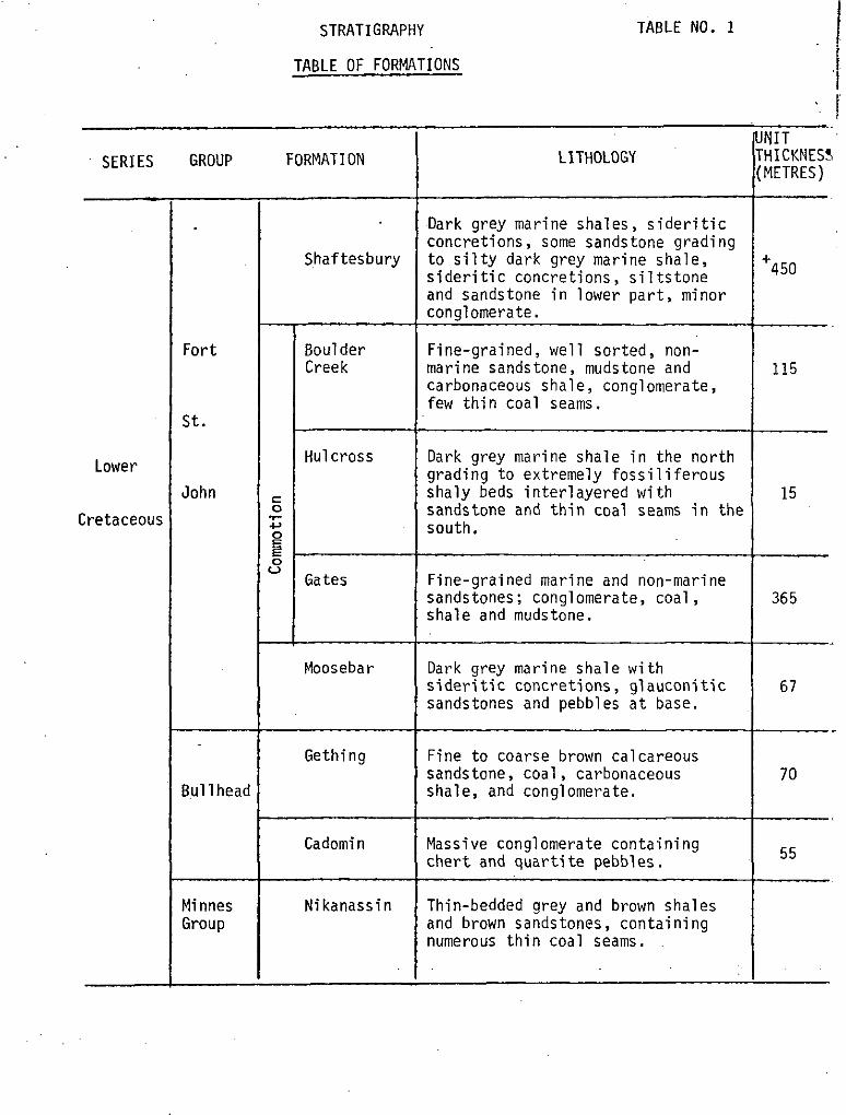
STRATIGRAPHY TABLE NO. 1
TABLE OF FORMATIONS
SERIES GROUP FORMATION LITHOLOGY
Lower
Cretaceou!
Fort
St.
John
3~11 head
Yinnes Sroup
Shaftesbury
Boulder Creek
Hulcross
Gates
Moosebar
Gething
Cadomin
Nikanassin
.Dark grey marine shales, sideritic concretions, some sandstone grading to silty dark grey marine shale, sideritic concretions, siltstone and sandstone in lower part, minor conglomerate.
Fine-grained, well sorted, non- marine sandstone, mudstone and carbonaceous shale, conglomerate, few thin coal seams.
Dark grey marine shale in the north grading to extremely fossiliferous shaly beds interlayered with sandstone and thin coal seams in the south.
Fine-grained marine and non-marine sandstones; conglomerate, coal, shale and mudstone.
Dark grey marine shale with sideritic concretions, glauconitic sandstones and pebbles at base.
Fine to coarse brown calcareous sandstone, coal, carbonaceous shale, and conglomerate.
Massive conglomerate containing chert and quarti te pebbles.
Thin-bedded grey and brown shales and brown sandstones, containing numerous thin coal seams.
I ‘. 1 NIT ~. HICKNESS YETRES)
I450
115
15
365
67
70
55

GENERALIZED STRATIGRAPHJC SECTION ‘Gates Memb&-r-- Commotion Formdtion
UNIT LITHOLOGY
&,i,n. shala shoroct~rlzsd by rhslly beds.’
SEAM NO.10 TO HULCROSS INTERSEAM STRATA
SEAM NO. 10
SEAM NO. 5-10 INTERSEAM STRATA - .
SEAM NO.5
SEAM NO.4-5 INTERSEAM .. STRATA
SEAM NO. 4
’ .
predomtncntly mudrtons with num~rc~s thin sandston beda and sevsral thin cccl sc~oms. One ccnplomerat~ bad pr*wtt In tha north of th@ prcpwty.
present k the southern port of thr property but I*nses cot towards tb. north. v
cloyston. unit interbedded with sondstcnq siltstow, and numerous ?hln coal ssams. Somr conglomwat~ preient 01 the or”,,. to thi .south -side of th* property.
appecn to rpllt and lens at sw~rct tocatlons through th, property. - ...
unit charocterlzed by sondstdne and slltstone to the south; cloyston~, shale and thin cccl rsoms to tha north side of tha propwty. -’
thlcknssr increase8 rapidly nsar th*’ centra ot and to Iho south of the propsrty.
unit charocterlz~d by sandstorm with cloystonb to the south rid. of th# property.
SEAM NO. 3 INTERSEAM STRATA
SEAM NO.;3 prsrant ot the north and south but absent “~a, tha
SEAM NO. 2-3 csntr. of tha propwty.
INTERSEAM sandston, unit chcracterired by claystons at top and
STRATA routh.8ld. of the propsrty; conglomerate to the north.
SEAM NO. 2 prerw~t thmu hoot thm SEAM NO. l-2 thick rock $ and
prop.,, in tb. so”, x.
but cbarcctsriz~d by 4
lNTERSEdJl STRATA sandstone unit chorccterlz~d by mudstone at top and bore
SEAM NO. I thlckans to th. north where sevsral splits on prwant.
BASAL GATES SANDSTONE
usually homogw%aus volt of madlcm to cows. grainad. , llthlc roodston&
MOOSESAR FORMATION
marine mudston* with thin slItston* Intarb@d nacr top.

16.
Gething Formation and located no coal seams in excess of 0.5m
thickness. One coal seam of economic thickness has been located
on the surface beyond the northern end of the property. No
information is presently available regarding its quality and
continuity.
The Gething Formation has an average thickness of 70 metres
on the Saxon property.
5.4 Moosebar Formation
On the Saxon property, the Moosebar Formation consists of
a monotonous sequence of dark grey marine shale containing
numerous sideritic concretions. The formation appears to conformably
overlie the Gething Formation, although a thin glauconitic pebble-
conglomerate is located at the base. This glauconitic unit is
thought to be the equivalent of the Bleusky Formation located in
the same stratigraphic position in central Alberta.
As in most other parts of the foothills, the boundary between
the top of the marine Moosebar Formation and the overlying,
predominantly non-marine, Gates Member of the Commotion Formation is
indistinct. A gradual increase insthe sandstone~interbeds is
observed.
The top of the Moosebar Formation is taken to be the appear-
ance of the first' prominent sandstone unit which has a thickness
of approximately 2 metres.on the property.
The average thickness of the Moosebar Formation on the Saxon
property is 67 metres. This distinct unit has greatly assisted
the definition of the structure of the property.
5.5 Coauaotion Formation
The Commotion Formation is subdivided into three members:
the Gates Member, the Hulcross Member and the Boulder Creek Member.

17.
: 5.5.I'Gates'Member
A) .General Stratigraphy
The section of the stratigraphy with the greatest economic
potention on the Saxon property is the Gates Member of the Commotion
Formation.
This mainly non-marine unit consists of sandstone, conglomer-
ate, coal, shale and mudstone and has an average thickness of
365 metres within the Saxon property. Contained within the total
thickness of Gates Member section are six potentially economic
coal seams which have an average total thickness of 18 metres.
The seams are labelled 1 to 5 and No. 10, as shown on the Saxon
correlation diagram (Drawing No. 76-0698-ROl). Three of these
seams, Nos. 1,2 and 4, form the bulk of the coal-bearing section
and together with No. 3 seam at Saxon South are the only ones
included at present within mining reserve categories.
B) Details of Seam Stratigraphy
As a result of detailed logging of drill cores, geophysical
logging and trench logging it has been possible to establish a
positive correlation between the coal seams encountered in Saxon
East with those in Saxon South. This correlation is especially
apparent when the seam characteristics of No. 4 seam are
examined; a rock band approximately 10 cm thick is consistently
found approximately 30 cm from the top while two thick rock bands,
each often as thick as 50 cm, are commonly located approximately
1 metre from the base of the seam. The rock band near the top
of'the seam is especially characteristic in outcrop, where it is
usually found to have a metallic blue sheen after weathering has
taken place. In addition, it has been found that the fine-grained
sandstone which immediately overlies the No. 4 seam is especially
abundant in fossil flora.

18.
Another seam characteristic which has aided the seam
correlation is found to occur at seam No. 1. The base of
this seam is distinguished by an abrupt change from coal
to the coarse-grained sandstone forming the seam floor.
This-feature was found to be unique: for all other seams
the floor material was found to be composed of mudstone,
carbonaceous claystone or silty mudstone with a somewhat
gradual reduction in the presence of coaly matter .in these
rock types.
The coal seam correlation in the northern part of the
property was further strengthened by the results gained
from D.D.H. 7616. Previously D.D.H. 7202 had been car-
related tentatively with D.D.H. 7003 in a manner which
indicated that seams No. 1 & 2 had not been intersected in
the former drill hole (c.f. 1975 Data Sumnary for Saxon
Coal Limited). A thick conglomerate unit intersected at
the base of D.D.H. 7202 had been interpreted in the field
to be part of either the Gethinq or Cadomin Formations but
later correlation placed it in the Lower Gates. In hole
7202 drilling was terminated at that horizon before the full
section was penetrated. The same Gates Member conglomerate
was intersected in D.D.H. 7616 and drilling was continued to
intersect two coal seams underlying the conglomerate. Sub-
sequent comparison of the seam characteristics, detailed
core logging, and geophysical logs, has established that the
original tentative correlation was correct and has, at the
same time, established the relationship between the strata
of Saxon West and the sequence at Saxon East on a firm basis.
The preceeding observations are illustrated in a general
manner on the Saxon Correlation Chart, Drawing No. SXON
76-0698-ROl, and in detail on the various trench and drill
core correlation diagrams included in the map packet and
listed in the Table of Contents.

19.
It should be noted that all seam correlation and stratigraphic
correlation diagrams have been corrected to true thickness
intervals for the 1976 data, while data from previous programs
included in the stratigraphic correlation is presented as core
intervals. The use of true thickness data allows the most meaning-
ful comparison of the data possible; correction of old logs to
true thickness was not carried out because of time limitations and
the lack of access to some of the earlier cores, which would have
had to be investigated to carry out this procedure with the same
degree of confidence that applies to this years work. In any
case, it is found that most of the pre-1976 drill holes were
made at an angle almost perpendicular to the dip of the bedding
and their sections thus approximate true thickness intervals.
C) Seam Thickness Variation
One of the major aims of the 1976 program at Saxon was to
establish the lateral continuity of the economic coal seams. On
the basis of previous work there was some possibility that the
coal seams at Saxon would be found to thicken and thin or in fact
lens out over very short lateral distances. This suggestion was
found to be invalid especially where drilling has been concentrated
in the proposed mining areas. The Correlation Diagram and Seam
Correlation Charts clearly show that only gradual variations of
seam thickness occur between trenches, drill holes and adit
Sections.
In only one case (seam No. 4 in D.D.H. 7613) was a rapid
change in seam thickness observed. In this section a sequence
of thin coal and rock material over the expected thickness and
at the correct stratigraphic level was identified by the geo-
physical logs. Investigation of the core of this section shows
the presence of numerous coal bands contained within tectonically
disturbed and slickensided mudstone and carbonaceous claystone.
SAXON SOUTH SAXON EAST
I I I NO.1 DESCRlPTlr!N
~..-- 1 BY>DrilE .- REVISIONS
SAXON COAL LIMITED
6’;;;;‘;d‘i COAL LIMITED ijf 1
SCHEMATIC CROSS ‘SECTION THROUGH SAXON PROPERTY
VIEWED TOWARDS THE NORTH
20.
This geological feature is interpreted to be a very local
structure; being either a washout which became the locus for
later tectonic movement or small-scale faulting at the seam
level. The surrounding adits and drill holes tend to verify
this-interpretation since they show no marked tendency towards
a thinning of the coal seam in this area.
In the Saxon South area, where a sufficiently well distributed
number of data points are available, isopach maps have been
prepared which clearly illustrate the lateral variations of
coal mining sections as well as "in seam" dilution. Variations
of seam thickness in Saxon East, where an insufficient spread
of data points occur to allow isopach maps to be prepared, are
~documented on the reserve maps for that area. The isopach maps .
and reserve maps are included in the map packet and are listed
in the table of contents.
It should be especially noted for seam No. 4 in the Saxon
South area, for which the greatest number of data points is
available, that the coal seam is thickest along the axis of the
main anticline in that area and thins somewhat on the limbs of
that structure. It is believed that this may be the result of
tectonic thickening of the seam during folding and it may be
found that a similar pattern exists for the other seams, when
further data becomes available.
D) Gates Member Interseam Sediments
Time Limitations have not allowed a detailed study of the
Gates Member interseam strata to be made to show the facies
variations of these small units through the various parts of the
Saxon Property. However general observations of the nature of
these units are complete and are presented within the preceeding
text figure. A thorough study of the variation of these units
is a necessary and valuable guide to both diamond drilling and
surface mapping. It is presently intended to carry out such a
study prior to ,the commencement of further field work.
21.
5.5.2 Hulcross Member
The maior stratigraphic problem in the Saxon property
concerns the identification of marker horizons which allow
precise coal seam correlation.
&thin the Rocky Mountain foothills, the dark grey marine
siltstones~ and shales of the Hulcross Member and the marine
shales of the Moosebar Formation are usually readily identi-
fiable and clearly establish the top and base of the Gates _
Member respectively. These markers assist in the interpre-
tation of geological structures and seam correlations.
However, on the Saxon property, while the Moosebar Formation,
has always been readily observed, the development of the
Hulcross Member has been retarded to such an extent that
this unit has often remained unobserved or has been mis-
correlated with similar thin shaley units. Therefore, for
practical local correlation purposes, the Hulcross Member
has been defined as that shaley unit, some 15 metres thick,
often characterized by an abundance of shelly fossils and
lying approximately 365 metres above the top of the Moosebar
Formation. This correlation is shown on the Saxon Strati-
graphic~correlation Drawing No. 76-06g8-ROl.
The Hulcross Member conformably overlies the Gates Member
and is similarly overlain by the Boulder Creek Member.
5.5.3. Boulder Creek Member
,The Boulder Creek Member consists of fine-to-medium-
grained, well sorted, mon-marine sandstone, containing phases
and inter-beds of mudstone, carbonaceous shale and conglomerate.
A few thin and discontinuous coal seams were intersected in
this unit, but these seams have proven to be of no economic
significance.
Most of the Boulder Creek strata are considerably more
resistant to erosion than the overlying beds of the Shaftes-
bury Formation. Thus, these older strata are largely responsible
for the development of the series of ridges trending along the
eastern side of the Saxon property.
22.
.The upper 25 metres of Boulder Creek Member Strata in D.D.H.
7602 consisted of carbonaceous claystone. mudstone and some
siltstone containing numerous thin coal bands. The contact
between the Boulder Creek Member and the overlying Shaftesbury
Formation is thus placed at the contact between the predominantly
marine and non-marine strata.
The Boulder Creek Member has a thickness of approximately
I15 metres on the Saxon property.
5.6 Shaftesbury Formation
The youngest stratigraphic unit on the Saxon property,
conformably overlying the Boulder Creek Member, is the Shaftes-
bury Formation. .
The Shaftesbury Formation consists of dark gray marine shale
containing sideritic concretions and some sandstone phases.
These lithologies grade in the lower half to silty dark gray
marine shale and siltstone, with sandstone and minor conglomerate
near the base.
Erosion has left only an incomplete section of this formation
near the south central part of the Saxon property. In this area,
a section containing 450 metres of the Shaftesbury Formation can
be observed.

6.0 STRUCTURE
23.
6.1 General Structure
On a large scale, the structure of the Saxon property
appears to be that of a large and complex synclinorium
trending northwest and plunging from both the southern and
northern ends to the centre of the property. The~central
portion of the property is thus a folded and faulted series
of the Lower Cretaceous strata surrounded by older Lower
Cretaceous rocks within the margins of the property. The
1:5000 geology maps and their cross sections, Drawing
Nos. SXON 76-0706-R01 and SXON 760689-ROl show the overall
structural style. The geology of the area is summarized on
the included 1:25000 map (Or-awing No. SXON 75-0616-ROZ). A
thrust fault has removed portions of the western limb of
the principal synclimorium, placing non-economic Minnes Group
strata over the Lower Cretaceous formations. A section
showing the general structure is included as the following
text figure.
6.2 Definition of Saxon Areas
Each of the areas, Saxon East, Saxon West and Saxon
South, have been defined by structural features which
separate them. Saxon East and Saxon West are separated by
a south westerly dipping thrust or reverse fault which
produces a repetition of the coal-bearing strata. All of
the strata lying east of the fault are considered to be in
the Saxon East area and the strata on the west side lie
within either the Saxon West or Saxon South areas. Saxon
South is separated from Saxon West by a further thrust
fault lying on the western side of the former fault.

24.
In the northern part of the Saxon property the fault
forming the boundary between Saxon East and Saxon West is
located near the centre of the northwestern property boundary
and strikes in a southeasterly direction parallel to the
strike of the beds. South of the Narraway River, the trend
of thi's fault swings in a more southerly direction where it
can no longer be traced in the tree covered Saxon valley.
From that point Saxon East continues to be defined by the
southeasterly trending alpine ridges to the southern end of
the property.
.The fault separating Saxon West and Saxon South has its
northern limit against the western exposures of the Nikanassin
Formation immediately south of the Narraway River. The fault
trends southeasterly to continue beyond the southern end of
the property at a point close to the centre of the southern
property boundary (B.C. border).
6.3 Saxon South
In general, Saxon South consists of a large northwesterly
trending anticline. In detail there are several northwesterly
plunging synclines and anticlines separated by several
extremely steeply dipping reverse faults. The trend of the
fold axes is quite variable along strike and in places
significant folds die out over remarkably short distances.
Reference to the Saxon South geology map (Drawing No. SXON
76-0700-ROl) and then cross sections (Drawing No. SXON 76-0689-
ROl) illustrates the internal structure of that portion of
the property.
6.4 Saxon West
The internal structure of Saxon West is poorly understood
because most of this area,lies within the densely.vegetated
and. poorly exposed portion of the property located in the
25.
central Saxon valley. However, one fault repeated portion,
formed in a manner identical to that which separates Saxon
East from Saxon West, has been identified on the east side of
the Saxon West area. On the west side of this fault the
strata are folded.into two parallel anticlines, separated by
a syncline trending southeasterly north of the Narraway River.
6.5 Saxon East
In general, Saxon East consists of a series of uniformly
dipping strata which trend southeasterly along the eastern
property boundary. The dip of the strata varies from 35
degrees at the northern end of the property to 60 degrees at
the southern end of the property.
In the same style as fault repeated strata located in
the northern part of the Saxon property, similar smaller fault
repeats have been reported and mapped in Saxon East south of
the Narraway River. In general, the faults in this part of
the property are located in the older Lower Cretaceous strata
and usually affect only the Cadomin and Gething Formations.
At the southern end of the property, however, adjacent to
the British Columbia - Alberta provincial boundary, one of
these structures is of sufficient magnitude to thrust strata
of the Gething Formation over the Gates Member.
6.6 Fault Orientation
With a few exceptions, the nature of the thrust faulting
in the Saxon East area can be described according to a single
pattern. The faults are commonly encountered in the well
exposed eastern ridge, and in this area they are steeply
dipping from 50' to approximately 70'. It has also been
observed that the bedding in this area dips in the order of
35O to 5o". The angular relationship between the.faults and
bedding is thus in the range of 10' to 20'. It should be

26.
noted that in many areas of flat dipping strata within the
Rocky Mountain foothills north of the Saxon property, a
similar relationship between thrust faulting and bedding is
observed. In these areas, of course, the thrust faults have
a shallow overall dip. At this time,.it is not known whether
the dttitude of the thrust faults has been caused by their
generation at a high angle or whether folding of the strata
postdated faulting.
One of the exceptions to the above mentioned pattern of
faulting lies within Saxon East, south of the Narraway River.
A loss of the stratigraphic section was observed in drill
hole S.D. 7001 and a large faulted section occurred towards
the base of drill hole S.D. 7620. Small scale structures in
the drill core indicated that this loss of section was due
to thrust faulting. Investigation of surface data and
consideration of this loss of section suggest that thrust
faulting must have taken place at a lower dip angle than
the dip of the strata. Although this interpetation was
further tested in 1976, additional work will be necessary to
fully document this feature for mining purposes.
Another exception to the general pattern occurs.at
Saxon South where the faulting is reverse in style dipping
between 70' and 90' independently of the dip of the strata.
In addition, the direction of dip may be either easterly or
westerly. At the present time no particular mechanism has
been developed to explain the orientation of these structures.
6.7 Effects of Structure on Mining
The internal folding and faulting of the Saxon syncline
has generated the various potential mining districts. The
imbricate thrust sheets of the Gates Member in Saxon East
have generated areas suitable for mining by hydraulic methods.
In addition, folding and faulting has generated.a'broad
antlcline of exposed Gates Member strata in Saxon South where
coal seams ne,ar the surface may be mined by open pit methods.
27.
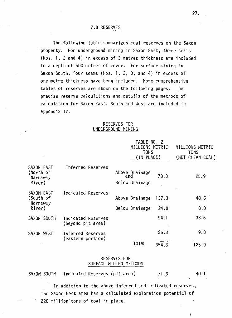
7.0 RESERVES
The following table summarizes coal reserves on the Saxon
property. For underground mining in Saxon East, three seams
(Nos. 1, 2 and 4) in excess of 3 metres thickness are included
to a depth of 500 metres of cover. For surface mining in
Saxon South, four seams (Nos. 1, 2, 3, and 4) in excess of
one metre thickness have been included. More comprehensive
tables of reserves are shown on the following pages. The
precise reserve calculations and details of the methods of
calculation for Saxon East, South and West are included in
appendix IV.
RESERVES FOR UNDERGROUND MINING
SAXON EAST (North of
Narraway River)
SAXON EAST (South of
Narraway River)
SAXON SOUTH
SAXON WEST
SAXON SOUTH Indicated Reserves (pit area) 71.3
Inferred Reserves
Indicated Reserves
Indicated Reserves (beyond pit area)
Inferred Reserves (eastern portion)
TABLE NO. 2 MILLIONS METRIC
TONS (IN PLACE)
Abov;ngrainage 73.3
Below Drainage
Above Drainage 137.3 48.6
Below Drainage 24.8 8.8
94.1 33.6
25.3
TOTAL 354.8
RESERVES FOR SURFACE MINING METHODS
-
MILLIONS METRIC TONS
(NET CLEAN COAL)
25.9
9.0
125.9
40.1
In addition to the above inferred and indicated reserves,
the Saxon West area has a calculated exploration potential of
220 milliontons of coal in place.
dN COAL LIMITE
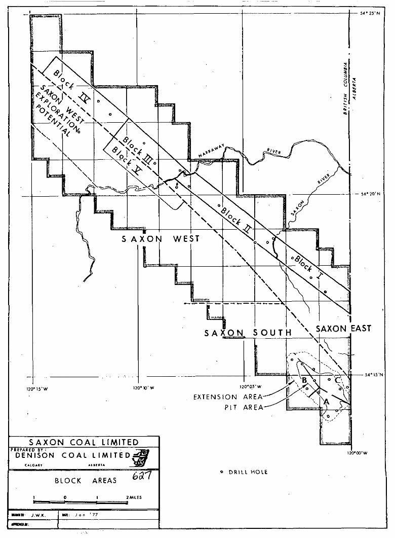
BLOCK AREAS
xmm -_- __i- -------
I
/ ‘\.f$f--q
SOlJTh ‘\. sAXoN EAST
EXTENSION AREA
28.
The Plant feed ratio calculated for raw coal to which
mining and geological factors have been applied is 8.85/l
cublic metres/metric ton or 11.75 cu. yd./long ton. This
ratio excludes coal with less than 15 metres cover (oxidized)
and does not include smaller seams above No. 4 seam.
7.1 Definition of Reserve Areas
The property has been divided into three parts for ease
of discussion within this report (see Figure No. 3).
Saxon East: That area bordered in the east and south by the
property boundary and the British Columbia/
Alberta provincial boundary respectively. This
area encompasses the northwest, southeast third
of the property.
Saxon West: That area bordered to the east and west by Saxon
East and the property's western boundary respec-
tively, excluding the southwestern sector of the
property. This area encompasses most of the
remaining two thirds of the~property.
Saxon South: The remaining southermost portion of the property
bounded on the north and east by Saxon West, and
on the south and west by the property boundaries.
7.2 Basis for Reserve Calculation
Since the amcunt'and type of information varies from one
area to another, a number of parameters were applied to the
reserve calculations and these are explained as follows:
7.2.1 Saxon East Area
In Saxon East information from twelve drill holes, five
adits and three trenches is available from which seam thick-
nesses and coal quality have been determined. An analysis of
. SAXON EAST INDICATED RESERVES (PLANIMETRY METHOD) TABLE NO. 3
PORTION BELOW BASE OF FLUME LINE TO 500 METRE DEPTH
AVERAGE AVERAGE COAL AREA SEAM VOLUME SPECIFIC IN PLACE
;EAM BLOCK (SQ.M. x 10~) SE& THICKNESS(M.) (CU.M. x lo61 GRAVITY NETsCLEAN
METRIC TONS x 10
l(oxidized - I(unoxidized) 0.25
ll(oxidized) 0.02 ll(unoxidized) 1.42 ll(oxidized') 0.01 ll(unoxidized) 0.90 ll(oxidized) 0.02 ll(unoxidized) 1.02
TOTAL (OXIDIZED) (UNOXIDIZED)
l(oxidized) 0.10 l(unoxidized) 3;74 l(unoxidized) 0.26
(flume-500M) ll(oxidized) 0.12
l(unoxidiz&d) 3.70
.+ (oxidized) 0.10
l(unoxidized) 3.63 ll(unoxidized) 0.23
(flume-500Mj ll(oxidized) 0.13 ll(unoxidized) 3.40 ll(unoxidized) 0.15
(flume-500M)
TOTAL
GRAND
(OXIDIZED) (UNOXIDIZED) (UNOXIDIZED) (FLUME-500Mj (UNOXIDIZED)
1.156 1.346 1.346 1.346 1.346 1.346 1.346
1.346 1.346 1.346
1.346 1.346 1.346 1.346 1.346
1.346 1.346 1.346
8.78 2.02 1.45- 4.31 0.08 1.45 4.64 6.61 1.45 2.94 0.03 1.45 2.95 2.65 1.45
0.10 1.45 5.80 1.45
x.-s-I:0 - 0.21
17.08
PORTION ABOVE BASE OF FLUME LINE
9.98 0.98 1.45 10.52 39.31 1.45 13.69 3.59 1.45
5.59 0.69 1.45 5.46 20.22 1.45 3.83 0.40 1.45 4.11 14.96 1.45 4.51 1.02 1.45
4.51 0.56 1.45 4.40 14.98 1.45 4.00 0.61 1.45
2.63 3.81 1.59 89.48 129.75 54.04
5.22 7.57 3.16
94.70 137.32 57.20
TOTAL (OXIDIZED) 2.84 4.12 1.72 (UNOXIDIZED) 111.78 162.09 67.52
2:93 1.22 0.11 0.05 9.58 3.99 0.05 0~.02 3.84 1.60 0.15 0.06 8.42 3.51
0.31 0.13 24.77 , 10.32
1.42 0.59 57.00 23.74
5.21 2.17
1.00 0.42 29.32 12.21
0.57 0.24 21.70 9.04
1.48 0.62
0.82 0.34 21.72 9.05
0.88 0.37
A further factor of 85% can be applied to the net clean coal grand total to allow for geologically related mining problems. Thus allowance can be made for termination of mining due to such geological problems. The application of this factor would give the following:
0
Below ba,se of flume line unoxidized 8.77 x lo6 metric'tons
Above base of flume line unoxidized 48.61 x lo6 metric tons
Grand total above and below flume.line unoxidized 57.38 x lo6 metric tons
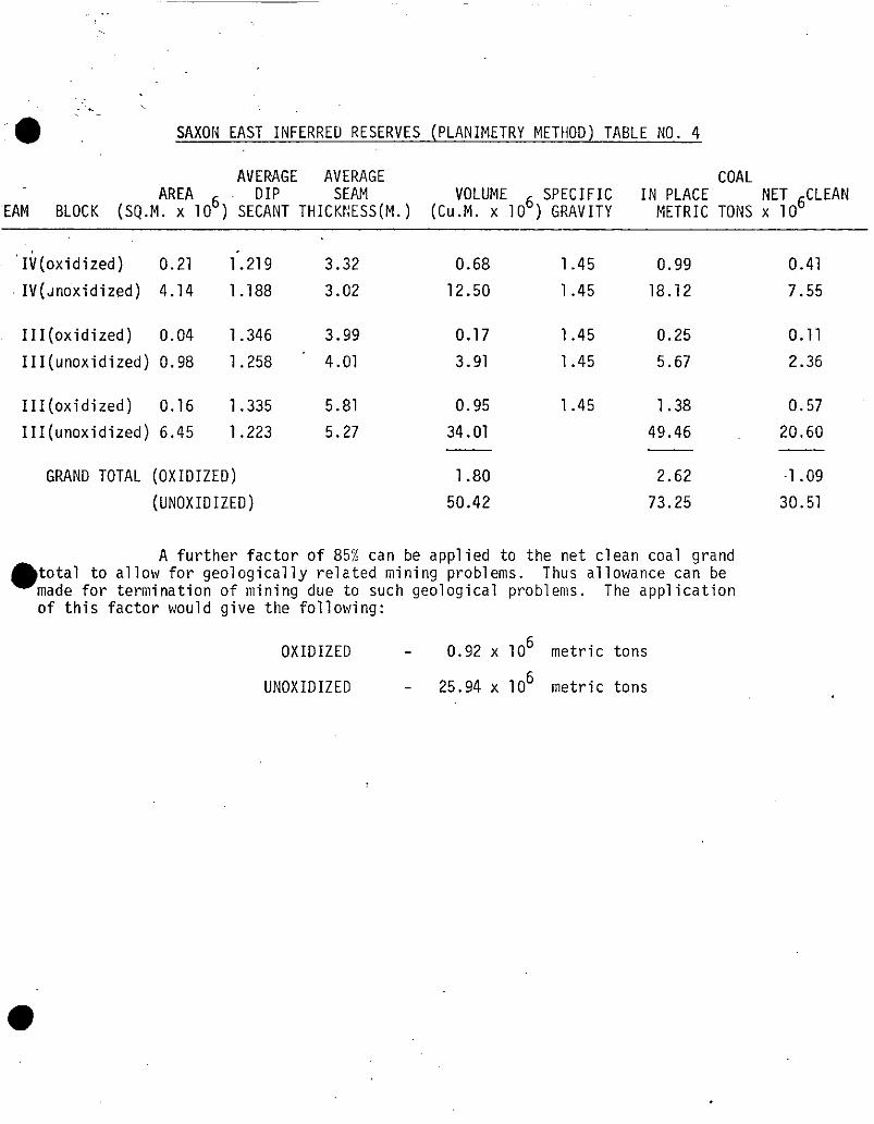
” l :_:_- ,’ sAx011 EAST INFERRED RESERVES (PLANIMETRY METHOD) TABLE ~0. 4
AVERAGE AVERAGE COAL IN PLACE NET 6CLEAN
METRIC TONS x 10
'Ii(oxidized) 0.21 1'.219 3.32 0.68 1.45 0.99 0.41
IV(Jntixidized) 4.14 1.188 3.02 12.50 1.45 18.12 7.55
III(oxidized) 0.04 1.346 3.99 0.17 1.45 0.25
III(unoxidized) 0.98 1.258 4.01 3.91 1.45 5.67
III(oxidized) 0.16 1.335 5.81 0.95 1.45 1.38
III(unoxidized) 6.45 1.223 5.27 34.01 49.46
GRAND TOTAL (OXIDIZED) 1.80 2.62
(UNOXIDIZED) 50.42 73.25
l A further factor of 85% can be applied to the net clean coal grand
total to allow for geologically related mining problems. Thus allowance can be made for termination of mining due to such geological problems. The application of this factor would give the following:
OXIDIZED - 0.92 x lo6 metric tons
UNOXIDIZED - 25.94 x 10⁶ metric tons
0.11
2.36
0.57
20.60
.1.09
30.51
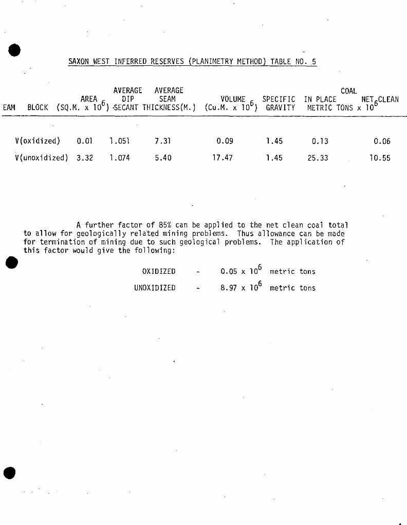
SAXON WEST INFERRED RESERVES (PLANIMETRY METHOD) TABLE ~0. ~5
AVERAGE AVERAGE COAL AREA SEAM VOLUME SPECIFIC IN PLACE
'EAM BLOCK (sQ.M. x lo6) .sEF:~~ THICKNESS (CU.M. x 106) GRAVITY NET&LEAN
METRIC TONS x 10
V(oxidized) 0.01 1.051 7.31
V(unoxidized) 3.32 1.074 5.40
0.09 1.45 0.13 0.06
17.47 1.45 25.33 10.55
A further factor of 85% can be applied to the net clean coal total to allow for geologically related mining problems. Thus allowance can be made for termination of mining due to such geological problems. The application of this factor would give the following:
l OXIDIZED - 0.05 x lo6 metric tons
UNOXIDIZED - 8.97 x lo6 metric tons

29.
the drill hole data was made firstly to establish true seam
thicknesses from cored intervals and geophysical logs and
secondly to determine the portions of the seam intersections
with an acceptable wash yield which would represent seam
mining sections. A summary of this analysis is given in
Appendix V. Graphic logs, used to determine the mining
sections for drill holes, adit and trenches, are included as
Appendices I and 1.1.
The seam thicknesses included in the reserve calculation
are taken only from seam Nos. 1, 2 and 4 where the thickness
is in excess of three metres and where expected seam wash
yields could be shown to be approximately 70% at a reasonable
ash value. In some instances, where poor core recoveries were
encountered, the yield was recalculated from the sink/float
data assuming that the lost core was mostly coal. This is
usually found to be valid: the top quality coal in the Rocky
Mountain foothills strata is often ground and flushed away in
the drilling process.
Once the location and thickness of the mining section
was determined, a series of structure contour maps for each
of the economic seams was prepared. These contour maps extend
to a 500 metre overburden depth limit and include an "above
drainage" portion above a four degree flume line drawn from
the proposed mining entry to the seams. In one instance this
flume line lies slightly below the 500 metre overburden line.
Reserve calculations.for the portions above and below drainage
(the flume line) have been made separately, as is shown on
Table No. 2, as an aid to engineering. The prepared structure
contour maps for reserve calculation terminate at a line drawn
where the seams are fifteen metres vertically below the topo- cc-\
graphic surface. The portion of the seam between this line
and the surface outcrop is excluded from the calculations to
allow for oxidized coal. To determine raw coal tonnage a
Specific gravity of 1.45 was applied. Calculatipn.of reserves
30.
was then made using the contour map planimetry method which
is fully described in Appendix IV and the summary table of
reserves by mining blocks is presented on the previous page.
TO check the results of this calculation a series of
crosssections through the same area and spaced at 500 metre
intervals was prepared. Using the same parameters and seam
thicknesses described above, the reserves were again calculated
by the cross section method. A detailed description of this
method and comparison tables of the results of the calculation
is included in Appendix IV. The reserve maps, for Saxon East,
Drawing No. 76-0723-ROl, are included in the map packet.
7.2.2 Saxon South Area
In Saxon South the surface mining potential has been
considered as well as the additional potential for underground
mining, and separate reserve figures for both portions of the
area are included in Table No. 2. For the open pit reserves
calculation, the geological staff of Denison Coal Limited
worked in close conjunction with the staff of Montreal
Engineering Limited to determine the reserves and a pit limit
which fulfilled the economic constraint of an overall maximum
plant feed ratio of g.O/l.
Geologic mapping has established in Saxon South the
presence of four seams which are considered to be of economic
thickness. Isopach maps of these four seams based on drill
core intervals, adit sections, and hand trenches, were prepared.
Reserve calculations have been made for these seams where the
mining section of each seam is in excess of 1.5 metres for
dips greater than 30°, and 1 metre or more for dips less than
3o".
To estimate the reserves, calculation by the cross section
method described above was carried out using sections spaced
200 metres apart. To check these reserve calculations, structure
contour maps of the seams were prepared and seam volumes were

: -_
31.
determined by the planimetry method. The same allowance for
oxidation as had been used in Saxon East was applied. A
comparitive table of results of the calculation of reserves
in Saxon South are shown. The results obtained by planimetry
are included in Appendix No. IV. The reserve maps, Drawing
No. SXON 76-0722-ROl, are enclosed in the map packet.
NOTE: It is believed that significant portions of seams
Nos. 5 and 10 may also be mined by surface methods.
Since these seams lie above the mineable seams in
Saxon South, they are presently included within the
overburden portion of the reserve calculations.
If it can be shown that even relatively small tonnages
of these seams can be mined, a significant reduction
of the overburden ratio may be obtained. Further
exploration of these seams would be required to
resolve this issue.
7.2.3 Saxon West Area
In the Saxon West area, an exploration potential has
been calculated on the basis of the mapped surface outcrop
area of the coal bearing Gates Member and from a regional
knowledge of total Gates coal thicknesses together with the
three drill holes located'in the area in adjacent localities.
These calculations are included in Appendix No. IV.

33.
9. CONCLUSIONS
All information gathered from exploration programs
to date shows excellent coking coal is available at Saxon.
Coal reserves of 40.1 million metric clean tons which
could be mined by open pit methods, have been located in
the Saxon South area. These reserves are shown to have an
overall metric plant feed ratio of 8.85/l. Beyond the
immediate pit area for Saxon South net clean coal reserves
of 33.6 million metric tons have been calculated giving a
total indicated clean coal reserve for that area of 73.7 million
metric tons.
In Saxon East the additional exploration has raised the
reserves south of the Narraway River to an indicated category.
In this area a total of 162.1 million metric tons in place has
been calculated of which 57.4 million metric tons could be mined
and processed as clean coal.
North of the Narraway River the coal reserves of Saxon East
are considered to fall into an inferred category. 73.3 million
metric tons of coal in place yielding 25.9 million metric tons
of clean coal have been calculated;
Additional drilling and surface mapping has shown that the
portion of property lying immediately west of the Saxon East block
which was formerly considered to be part of Saxon East should,
in fact, be placed in Saxon West. Such an interpretati~onof the
geology was applied during 1976 and inferred reserves for that
portion of Saxon West was determined. These inferred reserves
total 25.3 million metric tons in place which could yield 9.0
million metric tons of clean coal. An exploration potential of
220 million metric tons has been tentatively applied to the
remainder of Saxon West.
The exploration carried out during 1976 has firmly established
the geological correlation of the Gates Member strata throughout
the Saxon property and shown that the major economic coal seams
have developed with marked continuity through much of it.
Further exploration, especially by hand trenching, diamond
drilling and detailed geological mapping, will allow the coal
reserves under the various reserve categories to be brought to
a proven reserve category.
34.
10. EXPLORATION PROGRAM PERSONNEL
During the 1976 Exploration Program for Saxon Coal Limited
technical supervision and data analysis was carried out by the
staff~of Denison Coal Limited with assistance from personnel
from.Montan Consulting. The professional staff involved are
listed below:
DENISON COAL LIMITED
Mr. ALAN A. JOHNSON
Mr. GEOFF. JORDAN
Mr. ED. SANTIAGO
Mr. TED WATCHUK
Mr. HANS PALLOKS
Mr. IVAN DALAS
Ms. GEORGIA HOFFMAN
Mr. CHARLES MANKOWSKI
Mr. MATTHEW DUFORD
MS/ALICE BIENIA
CHIEF GEOLOGIST
PROJECT GEOLOGIST
SENIOR GEOLOGIST GEOLOGIST
II #I II II II I8
Extremely valuable assistance was also provided by a team
of technically qualified geological assistants.
MDNTAN CONSULTING
Mr. KARL ENGELS CONSULTANT GEOLOGIST
The efforts of these people to aid in the successful completion
of this program and the preparation of this report is gratefully
acknowledged. The advice and assistance of members of the various
,British Columbia government agencies, especially the British
Columbia Department of Mines and Petroleum Resources and the
British Columbia Forest Service is also acknowledged with thanks.
APPENDIX III
CURRENT SCHEDU1.E OF COAL LICENCES
SAXON PROPERTY
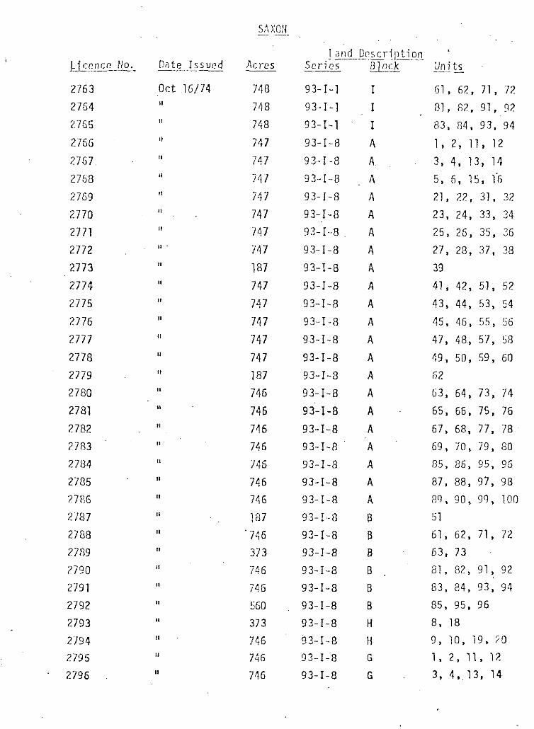
~jcencr yo.
2763
2764
2765
2756
2767.
2768
2769
2770
2771
2772
2773
2774
2775
2776
2777
2778
2779
2780
2781
2782
2783
2784
2785
27%
2787
2788
2739
2790
2791
2792
2793
2794
2795
2796
AC,-CS --
748
748
748
747
747
747
747
747
747
747
187
747
747
747
747
747
187
746
746
746
746
746
746
746
187
746
373
746
746
5GO
373
746
746
746
93-I-1 I 61, 62, 71, 72
93-I-l I 81, 82, 91, 92
93-I-l I 83, 84, 93, 94
93-I--8 A 1, 2, 11, 12
93-1-R A 3, 4, 13, 14 93-I--R A 5, 6, 15, 1'G
93-I-8 A 21, 22, 31, 32
93-I-a A 23, 24, 33, 34 93-.1-a A 25, 26, 35, 3G
93-I-8 4 27, 28, 37, 38
93-I-a A 39
93-I-8 A 41, 42, 51, 52
93-I-8 A 43, 44, 53, 54
93-I--a A 45, 46, 5.5, S6
93-I-a A 47, 48, 57, 58
93-I--8 A 49, 50, 59, GO
93-I-8 A 52
93-I-8 A G3, 64, 73, 74
93-I-a A. 65, 66, 75, 76
93-I-a A 67, 68, 77, 78
93-I-8 A 69, 70, 79, a0
93-I-a A 85, 86, 95, 95
93-I-8 A 87, 88, 97, 98
93-I-8 A 89, 90, 99, 100
93-I-f3 8 51
93-I-8 8 til, 62, 71, 72
93-I -8 B 63, 73
93-I-a B. al, 82, 91, 92
93-I-a B 83, a4, 93, 94
93-I-a B 85, 95, 96
93-I-a H 8, 18
93-1.-a H 9, IO, 19, 10
93.-I-~8 G 1, 2, 11, 12
93-I-a G 3, 4,.13. 14
Units
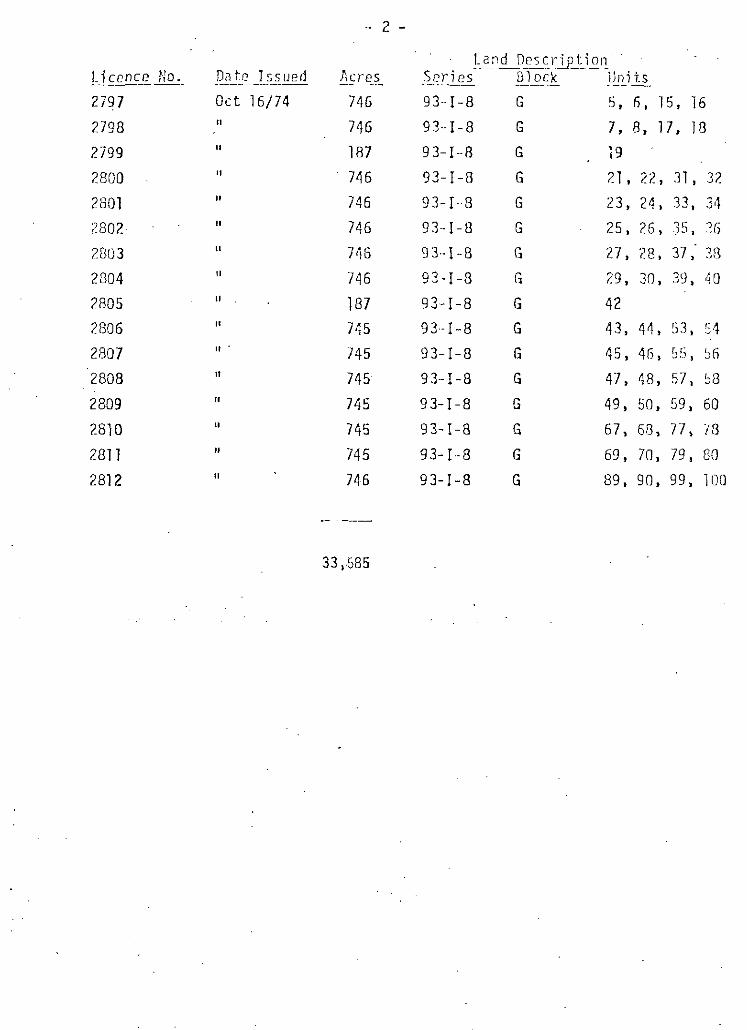
j.icence Ho. __-__ 2797
2798
2799
2800
2801
2802~
2803
2804
2805
2806
2807
2808
2809
2810
2811
2812
ACi-t2S Series-
746
746
187
746
746
746
746
746
187 745
745
745
745
745
745
746
33 ,-585
93--I-8 G
93--I-8 G
93-I-8 G
93-I-8 G
93-I-D G
93--I-U G
113-I-E G
93-I-8 G
93-I-8 G
93.-I-8 G
93-I-8 G
93-I-8 G
93-I-8 G
93-I-8 G
93-I--8 G
93-I-8 G
Uni is
5, 6, 15, 16
7, 8, 17. IA
19
21, 22, 31, 32
23, 24, 33, 34
25, 26, ;t;, ?6
27, 28, 37,' 38
29 , 30, 39, 40
42 43, 44, 53, "4
45, 46, 55, 56
47, 48, 57, 58
49, 50, 59, 60
67, 6R, 77, 78
69, 70, 79, 80
89, 90, 99, loo


