Page 1
SCOPE OF WORK
FIELD SURVEY AND RIGHT OF WAY PLANS
NON PROJECT SPECIFIC for REGION 1
April 13, 2016
PROJECT NUMBER: Non Project Specific Surveying and Right of Way
PROJECT LOCATION: Region One or other CDOT regions in Colorado
Page 3
Table of Contents
SECTION 1 - PROJECT SPECIFIC INFORMATION
1.01 Project Goal ...................................................................................................................1
1.02 Project Location .............................................................................................................1
1.03 Work Duration ...............................................................................................................1
1.04 Consultant Responsibility ..............................................................................................1
1.05 Work Product .................................................................................................................2
1.06 Work Product Completion .............................................................................................2
1.07 Additional Project Information ......................................................................................2
1.08 Scope of Work Organization .........................................................................................3
SECTION 2 - PROJECT MANAGEMENT AND COORDINATION
2.01 CDOT Contacts ..............................................................................................................4
SECTION 3 - PROJECT DESCRIPTION
3.01 Surveying .......................................................................................................................5
3.02 Right-Of-Way Plans Preparation ...................................................................................6
3.03 Photogrammetry (TMOSS) ............................................................................................6
3.04 Administrative Support ..................................................................................................6
3.05 Traffic Control ...............................................................................................................6
3.06 Quality Control ..............................................................................................................6
3.07 Title Work ......................................................................................................................7
SECTION 4 - GENERAL INFORMATION
4.01 Contract Provisions ........................................................................................................8
4.02 Authorization to Proceed ...............................................................................................8
4.03 Project Coordination ......................................................................................................9
4.04 Routine Reporting and Billing .......................................................................................9
4.05 Personnel Qualifications ..............................................................................................10
4.06 CDOT Computer/Software Information ......................................................................10
4.07 Computer Data Compatibility ......................................................................................10
4.08 Project Standards .........................................................................................................11
SECTION 5 - PRECONSTRUCTION WORK TASK DESCRIPTIONS
5.01 Project Initiation and Continuing Requirements ..........................................................12
5.02 Project Development ...................................................................................................12
5.03 Preliminary Design ......................................................................................................13
SECTION 6 - SUBMITTALS .......................................................................................................15
SECTION 7 - CONTRACT CONCLUSIONS
7.01 Supplemental Work .....................................................................................................17
7.02 Contract Completion ....................................................................................................17
Page 4
SECTION 8 - PRECONSTRUCTION WORK TASK DESCRIPTIONS
8.01 Project Initiation and Continuing Requirements ..........................................................18
8.02 Project Development ....................................................................................................20
8.03 Preliminary Design ......................................................................................................24
8.04 Final Design .................................................................................................................28
SECTION 9 - SUBMITTALS
9.01 Reports .........................................................................................................................31
9.02 Electronic Data Submittals ..........................................................................................36
SECTION 10 - SERVICES AFTER DESIGN
10.01 Post-Design Plan Modification ....................................................................................39
10.02 Pre-Construction Services ............................................................................................39
10.03 Post-Construction Services ..........................................................................................39
Page 5
- 1 -
CDOT Region 1 – Field Survey / ROW Plans NPS Scope of Work
SECTION 1 Project Specific Information
1.01 Project Goal. This project is intended to provide project support for specific surveying
and right-of-way activities in Region One.
1.02 Project Location. Consultant activities will be in the Region 1 area. Region one includes
all or portions of the following counties: Arapahoe, Adams, Boulder, Broomfield, Clear
Creek, Denver, Douglas, Gilpin, Park, and Jefferson in Colorado. The contract may be
used in other regions within the state of Colorado if necessary.
1.03 Work Duration. The work on this contract will be subject to supplements and funding
from projects for specific work tasks as needed for a period of two years.
1.04 Consultant Responsibility. The Consultant is responsible for one or more of the
following (defined by project Scope of Work):
A. Presurvey Meeting
B. Progress Meetings
C. Secure Right of Entry
D. Traffic Control and Traffic Control Plan
E. Underground Utility Locates
F. Survey Data Research
G. Establish Ground Control
H. Property/Boundary Surveys as needed
I. TMOSS Survey
J. Project Control Diagram and/or Preliminary/Final Land Survey Control Diagram
K. Map Compilation
L. Right-of-Way Research including adjoiners vesting deeds, title commitments, or
memorandums of ownership
M. Right-of-Way Plan/Map Preparation
N. Right of Way Mapping (Mapping of existing right of way only)
O. Right-of-Way Staking (Existing ROW, new ROW, TE's, SE’s, and PE's delineated for
Appraisal)
P. Right-of-Way Monumentation (CDOT Monument)
Q. Property Monumented Survey (As required per Colorado Revised Statutes)
R. Review By Registered Professional Surveyor
S. Slope and Structure Staking
T. Final TMOSS Survey
1.05 Work Product. The Consultant work products are (defined by project Scope of Work):
A. Project Schedule
B. Man-hour Proposal
Page 6
- 2 -
CDOT Region 1 – Field Survey / ROW Plans NPS Scope of Work
C. Cost Proposal
D. Project Progress Meeting Minutes
E. Traffic Control Plan(s)
F. Monument & Surveyed Ground Control
G. Signed and sealed Project Control Diagram and/or Preliminary and/or Final Land
Survey Control Diagram(s)
H. Digital TMOSS Data
I. Photography Products
J. All Documents Found In Research
K. Preliminary and Final Ownership Map
L. Original Field Notes
M. Survey Reports
N. Monuments on Right of Way Lines
O. Sealed ROW Plans and copies as filed in the County
P. Quality Control Reports
Q. Electronic Data
Detailed work product requirements are described in the following Sections.
1.06 Work Product Completion. All submittals are subject to approval by the CDOT
Contract Administrator or his designee.
1.07 Additional Project Information. Additional information regarding this project is
included in the following documents:
A. CDOT Survey Manual (Current Ed.)
B. CDOT Right-of-Way Manual (Current Ed.)
C. CDOT Standard Specifications for Road and Bridge Construction (Current Ed.)
D. CDOT CADD Manual (Current Ed.) (InRoads TMOSS, InRoads Geometry for ROW,
etc.)
E. CDOT M & S Standards (Current Ed.)
F. FHWA Manual on Uniform Traffic Control Devices for streets and roads (MUTCD)
(Current Ed.)
G. CDOT InRoads TMOSS coding booklet (Current Ed.)
Copies of these documents may be obtained from the internet. A moderate
fee, determined by document size, will be charged. An additional charge
will be added for requests by mail or for billing. Please provide a notice of
two working days prior to obtaining the document(s) in person. The most
recent edition of any CDOT publication will apply to individual task
orders issued under this contract and new editions will apply to new task
orders issued after the release of a new manual or publication.
Page 7
- 3 -
CDOT Region 1 – Field Survey / ROW Plans NPS Scope of Work
1.08 Scope of Work Organization. This draft scope of work has been carefully reviewed by
the Department and reflects a plan of approach based on the known goals. One factor
determining the selection of a Consultant is the ability of that consultant to analyze the
project goals, evaluate the work elements, and formulate a work plan. This process may
produce new approaches or modification to the project work elements. Because of that,
all consultants should be aware that the Final Scope of Work for a project will be
produced with the input of the selected Consultant.
Page 8
- 4 -
CDOT Region 1 – Field Survey / ROW Plans NPS Scope of Work
SECTION 2
PROJECT MANAGEMENT AND COORDINATION
2.01 CDOT Contacts
The Contract Administrator for this project is:
Mr. Paul Jesaitis
Region Transportation Director, Region 1
Active day-to-day administration of the contract will be delegated to the CDOT Project
Manager:
David A. Stewart
Professional Land Surveyor II, Region 1 – West Program
Colorado Department of Transportation
Region 1 Right of Way
2000 S. Holly Street.
Denver, Colorado 80222
[email protected]
Telephone (720) 497-6903
FAX (720) 497-6901
Page 9
- 5 -
CDOT Region 1 – Field Survey / ROW Plans NPS Scope of Work
SECTION 3
PROJECT DESCRIPTION
The consultant shall provide support in the following work disciplines:
3.01 SURVEYING
A. Surveying general procedures
B. Global Positioning System (GPS) surveys
C. Aerial surveys
D. Preliminary surveys
E. Construction surveys
F. Perform survey data research and preliminary field reconnaissance
G. Secure right of entry using CDOT forms (Form 730)
H. Geodetic surveys using FGCC Standards & Techniques including Blue Booking
(Conventional & GPS)
I. Project Control Networks tied to geodetic surveys based on NAD 83(2007)
(Conventional or Fast Static GPS) or current datum used by CDOT.
J. Vertical Control based on NAVD 88 datum
K. Prepare Project Control Diagrams
L. Prepare Preliminary and/or Final Land Survey Control Diagrams
M. Blue Book Vertical control with the National Geodetic Survey
N. Locate & Survey BLM & GLO Aliquot & Public Land Survey System Corners.
O. TMOSS survey utilizing the CDOT Field Code Library (InRoads TMOSS Coding
format) (Total Station, GPS RTK, etc.).
P. Right of Way Surveys
Q. Locate & Survey all private property monumentation required to resolve property
ownerships and locations and their intersections with the existing and proposed
CDOT Right of Way.
R. Property Surveys
S. Prepare preliminary ownership maps
T. ALTA/ACSM Surveys (As required per ACSM.)
U. Prepare monument recovery forms and records (CDOT, NGS, USGS, BLM or
required by Colorado survey laws)
V. Stake ROW Parcels, TE's, SE’s, and PE's for appraisers
W. Final Monumentation of ROW Line, SE’s and PE’s
X. Comply with all applicable Colorado Revised Statutes
Y. Prepare survey report using MicroStation V8 or newer, and InRoads. Using CDOT’s
latest configuration found at: http://www.coloradodot.info/business/designsupport/cadd/microstation-inroads-
config.html
Z. Prepare a quality control report
AA. Slope and Structure Staking using design data. (Post-design/Pre-construction)
Page 10
- 6 -
CDOT Region 1 – Field Survey / ROW Plans NPS Scope of Work
BB. Compute As-Constructed InRoads TMOSS survey and final earthwork. (Post
Const.)
3.02 RIGHT OF WAY PLANS PREPARATION
A. Perform research, calculations and drafting to determine existing CDOT
Right-of-Way within project limits defined by metes and bounds on the project
coordinate system. Deliver electronic data in InRoads and MicroStation.
B. Resolve private property/boundary locations and the intersection of these boundary
lines with the existing and proposed CDOT Right-of-Way.
C. Research ownership deeds
D. Prepare Right-of-Way Plans and Legal Descriptions. See Section 8.04 for more
detail.
3.03 PHOTOGRAMMETRY
A. Compile point #, Y, X, Z, code, and comment data using InRoads TMOSS codes (not
a conversion to InRoads TMOSS codes). InRoads TMOSS format and
methodology is described in the InRoads TMOSS booklet and InRoads Survey
Data Reduction training manual.
B. Through ground supplemental survey (1) find & locate any ROW Markers and
property corners (2) define all features on the project - fences, signs, culverts, all
underground features, utilities, pavement and features with sensitive elevation
requirements.
C. Provide digital ortho-rectified photos in TIFF format with accompanying TFW file.
D. Provide MicroStation drawings of InRoads TMOSS survey data
3.04 ADMINISTRATIVE SUPPORT
A. Perform clerical or word processing duties
B. Prepare billings and monthly progress reports
3.05 TRAFFIC CONTROL
A. Perform traffic control with planning, signing and properly trained personnel, using
MUTCD manual as a guide
B. Provide traffic control plans to be reviewed by the R-1 Traffic Engineer prior to
implementation.
3.06 QUALITY CONTROL
A. Prepare a report that describes the procedures incorporated into the work to assure and
control the quality.
Page 11
- 7 -
CDOT Region 1 – Field Survey / ROW Plans NPS Scope of Work
3.07 TITLE WORK
A. Performs title research and prepares memorandum of ownerships with attached
vesting deeds or the commitments for parcels to be acquired by CDOT.
B. Arranges for title policies for and on behalf of the Colorado Department of
Transportation.
Page 12
- 8 -
CDOT Region 1 – Field Survey / ROW Plans NPS Scope of Work
SECTION 4
GENERAL INFORMATION
4.01 Contract Provisions. The contract between CDOT and the Consultant shall be a cost
plus fixed fee contract. This basic non-project specific contract will set up the framework
for project specific task orders. Funds for actual work will be committed only by task
order and not by the NPS contract. The task order shall be initiated by:
A. Preparing a project specific Scope of Work.
B. Negotiating the number of hours by classification for each work element with the
CDOT Project Manager (CDOT PM).
C. Identifying the other direct costs needed to accomplish the Scope of Work.
D. Applying the pre-approved rates as established in the basic contract.
E. Negotiating the product delivery dates.
F. Identifying the total cost of work and resources needed to meet the project schedules.
G. Submitting one copy of the Project Cost/Manhour Work Sheet with original
signatures.
Each task order shall include a Scope of Work that describes the specific work to be
done. This Scope of Work shall be in specific detail in order to provide a basis for the
negotiation of the number of work hours. A meeting on the project site with the CDOT
Project Manager (hereon referred to as CDOT PM) is required for each Scope of Work
prepared. In the event the consultant experiences unexpected cost/rate changes, annual
rate changes, changes in the project team and/or costs, delays during the term of the task
order that require that the performance time of a task order be extended the consultant
shall request an amended task order. The consultant shall submit one copy with original
signatures to the CDOT PM of an amended task order request letter specifying the items
to amend and the reasons for the amendment. Back up documentation supporting the
request such as certified payroll reports detailing the salary or personnel change or
documentation that substantiates any delays are required with the request. The CDOT
PM then requests an amended task order from the CDOT Agreements and Consultant
Management section. Approval of the amended task order is by the Chief Engineer or
designee. All amendments to the task order require this formal process. Changes during
the course of a task order are not permitted unless the consultant has requested an
amendment. No payments will be made for work accomplished after the expiration date
of the task order. Payments of rates differing from or not included in the original task
order cannot be made without a formal amendment to the task order.
4.02 Authorization to Proceed. Work will not commence until the written notice-to-proceed
is received by the Consultant and all work will be completed within the allotted time. No
payments can be made for work accomplished outside the limits of the timelines set up by
the task order.
Page 13
- 9 -
CDOT Region 1 – Field Survey / ROW Plans NPS Scope of Work
Unanticipated changes that require that the performance time be extended must be
documented. These are unanticipated changes to the work schedule not caused by the
consultant. The consultant shall request that the task order be formally amended to
extend the time. The consultant shall submit a letter to the CDOT PM detailing the
reasons for the request, documenting the time lost, and asking for the amendment for a
time extension.
4.03 Project Coordination. The routine working contact will be between the CDOT PM and
the Consultant Project Manager (C/PM). Each Project Manager will provide the other
with:
A. Synopses of their respective contacts (both by telephone and in person) with others
B. Copies of pertinent written communications
Consultant is responsible for coordinating all sub-consultants and team members.
4.04 Routine Reporting and Billing. The Consultant will provide the following on a routine
basis:
A. Coordination of all contract activities by the C/PM
B. The periodic reports and billings required by CDOT Procedural Directive 400.2
C. Minutes of all Meetings. The minutes will be completed and will be provided to the
CDOT PM within five (5) working days after the meeting. When a definable task
is discussed during a meeting, the minutes will identify the "Action Item", the
agency responsible for accomplishing it, and the proposed completion date.
D. In general, all reports and submittals must be accepted by CDOT prior to their content
being utilized in follow-up work efforts.
E. The consultant shall submit a progress report with each billing.
F. The progress report shall include a statement addressing the project schedule and any
delays encountered.
G. The primary consultant shall be responsible for checking and verifying all
subconsultant and team member billings for compliance with the contract before
submitting to CDOT for payment.
H. The consultant must use the following personnel classifications for their firm’s
personnel when submitting task order proposals and billings to CDOT:
Right of Way Manager
Professional Land Surveyor II
Professional Land Surveyor I
Land Survey Intern II
Land Survey Intern I
Technician II
Technician I
Technician Assistant 1
Technician Assistant 2
Page 14
- 10 -
CDOT Region 1 – Field Survey / ROW Plans NPS Scope of Work
Technician Assistant 3
Administrative Assistant
The consultant shall assign each employee a title from the preceding list in lieu of
the terms Project Manager, Party Chief, Instrument operator, draftsman, CADD
operator, office tech, etc. A detailed Minimum Qualifications (MQ’s) description
outlining minimum education and experience, special requirements, and
substitutions and copies of the Class Descriptions (CD’s) for each position are
available upon request.
I. Monthly Status Reports. Each billing shall include a status report that includes the
total man-hours bid compared to the total billed to date for each position, a
percent complete for each work element.
4.05 Personnel Qualifications. The Consultant Project Manager (C/PM), must be approved
by the CDOT Contract Administrator. Tasks must be supervised by Licensed Professional
Surveyors who are registered with the Colorado State Board of Registration for
Architects, Professional Engineers and Professional Land Surveyors.
4.06 CDOT Computer/Software Requirements. The primary hardware used by CDOT is a
Personal Computer - Windows based operating system, and the types of software are:
Earthwork - InRoads
Drafting - MicroStation
Survey Control - Trimble Business Center (TBC)
Survey - InRoads TMOSS coding (developed by CDOT to convert total station
surveys, GPS and aerial surveys to MicroStation formats) and InRoads
Survey.
Geometry - InRoads
Microsoft Word, Excel, Access, Outlook, Power Point and Project are used at CDOT.
4.07 Computer Data Compatibility. CDOT presently utilizes three data formats which
consultants shall be required to use for submitting survey and design data: TMOSS
(Topography Modeling Survey System using the InRoads coding), InRoads and
MicroStation.
The data format used by the consultant to submit surveying data shall be as determined by
the CDOT PM. The data format for submitting design computer files shall be compatible
with the InRoads. The data format shall be submitted in English Units in US Survey feet
unless otherwise determined by the CDOT PM.
The consultant shall immediately notify the CDOT PM if the firm is unable to produce
the desired format for any reason and cease work until the problem(s) is resolved.
Page 15
- 11 -
CDOT Region 1 – Field Survey / ROW Plans NPS Scope of Work
Refer to Section 9.01 - SUBMITTALS, for additional information regarding InRoads
TMOSS, InRoads, MicroStation and the acceptable transmittal media.
4.08 Project Standards
A. General. The following is a list of technical references applicable to CDOT work.
The Consultant is responsible for ensuring compliance with the listed references.
Conflicts in criteria shall be resolved by the CDOT PM.
Colorado Revised Statutes, CDOT Survey Manual, Bureau of Land Management
Instructions to Surveyors, State Board of Registration Rules, CDOT Right of Way
Manual, NOAA National Geodetic Survey Specifications, Code of Federal
Regulations, CDOT Road and Bridge Specifications, CDOT CADD Manual,
Geometric Geodetic Accuracy Standards for Using GPS Equipment, Code of
Ethics for Surveyors and Employees, ALTA/ACSM standards
B. Specific Criteria. Attachment B is a list of specific project criteria (not applicable to a
NPS contract and not attached). The list is comprehensive and may include items that
are not required for tasks defined in this scope. The Consultant shall submit the
pertinent criteria to the CDOT PM at one of the periodic progress meetings prior to
initiating work.
Page 16
- 12 -
CDOT Region 1 – Field Survey / ROW Plans NPS Scope of Work
SECTION 5
WORK ACTIVITY ASSIGNMENTS
This list encompasses the consultant's individual task responsibility. The consultant shall
perform all work tasks which are indicated below by an 'X' mark in the consultant column, in
accordance with the forms and conditions of Sections 8-10, and the standards described in the
manuals and documents associated with this contract in Section 1.07 and Section 4.08 after
coordination and consultation with CDOT. The Consultant is also responsible for coordinating
the required work schedule for those tasks accomplished by CDOT and other agencies.
PRECONSTRUCTION- See Sections 8 and 9 for Work Tasks and Task Descriptions.
CDOT/OTHER CONSULTANT
&/or SUBS
5.01 Project Initiation and Continuing Requirements
A. Initial Project Meeting X X
B. Project Schedule Reviews
(Deliverables Deadlines) X X
C. Initiate Survey X X
D. Right of Entry & Permits X
E. Traffic Control X
F. Initial Submittals X
G. Progress Meetings X
H. Safety X
I. Project Management X
5.02 Project Development
A. Communication and Consensus Building
B. Contact List X
C. General Meetings
1. Small Group X
2. Project Review X
D. Communication Aids X
1. Graphics Support X
E. Route Location Surveys
F. Survey Manual General Procedures
1. Equipment Checking X
2. Calibration X
3. Error reduction X
4. Field notes X
5. Preliminary Survey scope X
6. Presurvey conference X
7. Special use permit X
8. MUTCD Traffic Control X
9. Permission to Enter Property X
10. Underground utility locates X
Page 17
- 13 -
CDOT Region 1 – Field Survey / ROW Plans NPS Scope of Work
CDOT/OTHER CONSULTANT
&/or SUBS
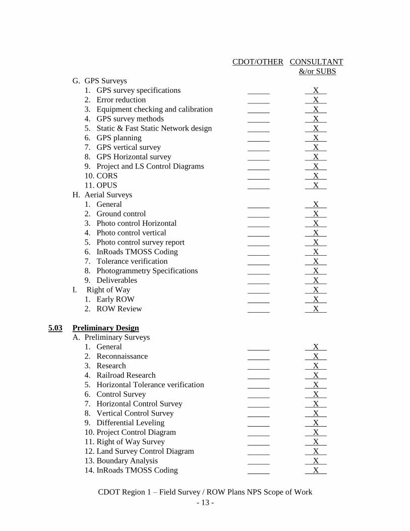
G. GPS Surveys
1. GPS survey specifications X
2. Error reduction X
3. Equipment checking and calibration X
4. GPS survey methods X
5. Static & Fast Static Network design X
6. GPS planning X
7. GPS vertical survey X
8. GPS Horizontal survey X
9. Project and LS Control Diagrams X
10. CORS X
11. OPUS X
H. Aerial Surveys
1. General X
2. Ground control X
3. Photo control Horizontal X
4. Photo control vertical X
5. Photo control survey report X
6. InRoads TMOSS Coding X
7. Tolerance verification X
8. Photogrammetry Specifications X
9. Deliverables X
I. Right of Way X
1. Early ROW X
2. ROW Review X
5.03 Preliminary Design
A. Preliminary Surveys
1. General X
2. Reconnaissance X
3. Research X
4. Railroad Research X
5. Horizontal Tolerance verification X
6. Control Survey X
7. Horizontal Control Survey X
8. Vertical Control Survey X
9. Differential Leveling X
10. Project Control Diagram X
11. Right of Way Survey X
12. Land Survey Control Diagram X
13. Boundary Analysis X
14. InRoads TMOSS Coding X
Page 18
- 14 -
CDOT Region 1 – Field Survey / ROW Plans NPS Scope of Work
CDOT/OTHER CONSULTANT
&/or SUBS &/or SUBS &/or SUBS &/or SUBS
15. Topographic Survey X
16. Drainage Survey X
17. Utility Survey X
18. Staking for Appraisal X
B. Utility Coordination
1. Location Maps X
2. Contact Locate Services X
3. Reviews and Investigations X
4. Underground Locates X
5. Ditch Co. Coordination X
C. Right of Way
1. Research X
2. Ownership Map X
D. Final Design
1. Right of Way Plans and Authorization Plans X
2. Post Field Inspection Review Revisions X
Page 19
- 15 -
CDOT Region 1 – Field Survey / ROW Plans NPS Scope of Work
SECTION 6
SUBMITTALS
CDOT/OTHER CONSULTANT
&/or SUBS
Section 4 - Project Initiation and Continuing Requirements
4.04-B Periodic Reports & Billings X
4.04-C Meeting Minutes X
Section 8.01 – Project Initiation and Continuing Requirements
8.01-A Man-hour Estimates X
8.01-A Project Cost Worksheet X
8.01-B Project Schedule X
8.01-C Survey Plan X
8.01-D Permission to Enter Forms X
8.01-E Traffic Control Plan X
8.01-F Initial Submittal of InRoads TMOSS X
8.01-F Initial Submittal of an Original Plan Sheet X
8.01-G Meeting Minutes X
Section 8.02 - Project Development
8.02-A-1 Permission to Enter Contact List X
8.02-B-1-b Equipment Calibration X
8.02-B-1-d Field Notes X
8.02-B-1-f Preliminary Survey Conference Minutes X
8.02-B-1-g Special Use Permits X
8.02-B-1-h Traffic Control Plan X
8.02-B-1-i Executed Permission to Enter Forms X
8.02-B-1-j Underground Utility Reports X
8.02-B-2-a to 8.02-B-2-h
GPS Quality Control Report X
8.02-C Photo control survey report X
8.02-C Planning maps, flight plan, camera
calibration report, negatives, contact prints,
photo index, photo enlargement prints,
digital images, analytical aerial
triangulation report, planimetric feature
identification, InRoads TMOSS
supplemental survey, mapping sheets,
digital terrain models, digital
elevation models, contours,
ortho-photography data X
8.02-D-a-(1) ROW Preliminary Cost Estimate X X
8.02-D-a-(1) Relocation Study X X
8.02-D-a-(6) Plat of Existing Right of Way X
Page 20
- 16 -
CDOT Region 1 – Field Survey / ROW Plans NPS Scope of Work
CDOT/OTHER CONSULTANT
&/or SUBS
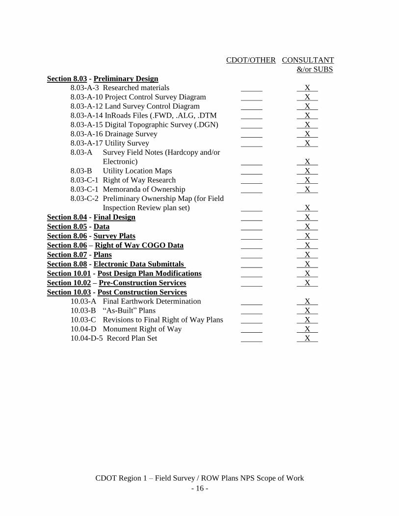
Section 8.03 - Preliminary Design
8.03-A-3 Researched materials X
8.03-A-10 Project Control Survey Diagram X
8.03-A-12 Land Survey Control Diagram X
8.03-A-14 InRoads Files (.FWD, .ALG, .DTM X
8.03-A-15 Digital Topographic Survey (.DGN) X
8.03-A-16 Drainage Survey X
8.03-A-17 Utility Survey X
8.03-A Survey Field Notes (Hardcopy and/or
Electronic) X
8.03-B Utility Location Maps X
8.03-C-1 Right of Way Research X
8.03-C-1 Memoranda of Ownership X
8.03-C-2 Preliminary Ownership Map (for Field
Inspection Review plan set) X
Section 8.04 - Final Design X
Section 8.05 - Data X
Section 8.06 - Survey Plats X
Section 8.06 – Right of Way COGO Data X
Section 8.07 - Plans X
Section 8.08 - Electronic Data Submittals X X
Section 10.01 - Post Design Plan Modifications X
Section 10.02 – Pre-Construction Services X
Section 10.03 - Post Construction Services
10.03-A Final Earthwork Determination X
10.03-B “As-Built” Plans X
10.03-C Revisions to Final Right of Way Plans X
10.04-D Monument Right of Way X
10.04-D-5 Record Plan Set X
Page 21
- 17 -
CDOT Region 1 – Field Survey / ROW Plans NPS Scope of Work
SECTION 7
CONTRACT CONCLUSIONS
7.01 Supplemental Work. This contract will be supplemented by task orders for specific
tasks during a two-year period.
7.02 Contract Completion. This Contract will be satisfied upon acceptance of the following
items (if applicable) to supplement(s) by task order:
Project Schedule
Project Progress Meeting Minutes
Traffic Control Plan(s)
All Documents Found In Research
All Permission to Enter Forms
Monumented & Surveyed Ground Control
Digital InRoads TMOSS Data
All Electronic Data from InRoads and MicroStation packages
Photography Products
Project Control Diagram
Final Land Survey Control Diagram deposited with appropriate county (counties)
Preliminary Ownership Map
Original Field Notes
Survey Report (Including monument recovery forms)
Quality Control Report
Monumented and Sealed ROW Plans
Legal Descriptions, Signed and Sealed
NOAA - NGS Blue Book
Memorandum of Ownerships
Title Commitments and policies
Deposited ROW Plans
and the completion of review of contract submittals.
Page 22
- 18 -
CDOT Region 1 – Field Survey / ROW Plans NPS Scope of Work
SECTION 8
PRECONSTRUCTION WORK TASK DESCRIPTIONS
The following includes work descriptions for all tasks normally accomplished during this phase
of the work. Work items listed may need to be advanced in time period in order to meet
compressed schedules.
The tasks that could be the responsibility of the consultant are identified in Section 5 of this
scope. The Consultant should review this entire section to identify applicable material. Contact
the CDOT PM if clarification is required.
The following activities of communication and consensus building, project team reviews,
conceptual design, gather data, documentation, and formal public notice should be planned by the
Consultant and coordinated with the CDOT PM to satisfy the requirements of the “Procedures
for Public Involvement and Participation in the Project Development and Environmental
Analysis Process”. The time of their accomplishment will overlap and parallel paths of activity
should be planned to finish the development phase in accordance with the shortest possible
schedule. The type and number of meetings, documents, etc. will depend on the category and
characteristics of the project work. A project plan will be developed by the Consultant that
satisfies the requirements of the project. This plan must be approved by the project manager
before starting the work.
8.01 Project Initiation and Continuing Requirements
A. Initial Project Meeting. An initial meeting will be held and an on-site inspection
(when appropriate) will be made to ensure that the Consultant is familiar with the
existing conditions as well as the project requirements. This meeting will be
coordinated by the Consultant and conducted by the CDOT PM. Notices for the
meeting are to be sent by the Consultant. A scope of work, man-hour estimate and the
project cost work sheet designated by the NPS contract will be developed from this
meeting.
1. If this contract is for the production of right of way plans, the consultant or
sub-consultant actually designing the right of way plans shall attend a
"pre-survey" conference with the CDOT PM.
2. A "Pre-Survey" conference between the consultant and the CDOT PM will be
held prior to any survey work performed. The CDOT Survey Manual provides
several agendas for the Pre-Survey Conferences.
B. The consultant shall submit a proposed schedule to complete each survey task with
each task order proposal. The schedule shall be negotiated with the CDOT PM before
the task order proposal is accepted. A Gantt chart created in Microsoft Project
showing all work tasks, the duration of each task, the resources assigned to each task,
Page 23
- 19 -
CDOT Region 1 – Field Survey / ROW Plans NPS Scope of Work
and the relationship of each dependent task shall be prepared and submitted to the
CDOT PM. It is the consultant’s responsibility to communicate and document any
delays or setbacks in the schedule in the monthly status reports and submit a revised
schedule Gantt chart.
C. The survey is initiated by the “Notice to Proceed” from the CDOT. The consultant is
then responsible to begin the work. A CDOT Form 1217a Preliminary Survey Scope
may be used as a guide for completing the survey scope. An example of the Form
1217a is included in the CDOT Survey Manual.
D. Obtain necessary right of entry (Permission to Enter - Form 730a) and permits. It is
useful to start the project contact list called for in Section 8.02 B. at this stage with the
names of the adjoiners to the project. This list in spreadsheet format (i.e. Microsoft
Excel) is used to make mailing labels and can be used to merge fields into subsequent
documents and communications with landowners adjoining the corridor. The digital
file of the list is a required submittal.
1. Some activities may require work on land not controlled by the CDOT. In such
cases the Consultant shall obtain the necessary written permission to enter the
premises. Included in this written permission will be the names and telephone
numbers of persons to contact should notification prior to entry be necessary.
These written permissions will apply to CDOT personnel as well as Consultant
personnel. CDOT Form 730a must be used for this purpose. Signed copies of the
written permission will be submitted to the CDOT PM prior to entering private
property for survey work. Include County Assessor number or state ID number on
Form 730a when submitting to CDOT so completed Permission to Enter can be
located on County Tax Plat.
2. Some activities such as materials testing on existing pavement and structures may
require a special use permit or temporary easement from the landowner. Permits
and temporary easements will be obtained by the consultant and copies submitted
to the CDOT PM.
E. Traffic Control. Consultant field activities that interfere with traffic operation within
existing roadways will require control of existing traffic. The Consultant will plan
and provide any required traffic control for the survey, testing, or design process.
Traffic control operations will be in accordance with the MUTCD. The Consultant
will note that the proposed method for handling traffic must be acknowledged in
writing by the CDOT PM. Also, certification of the Traffic Control Supervisor as a
Worksite Traffic Supervisor by the American Traffic Safety Services Association
(ATSSA) will be required. The consultant should schedule a two-week review period
for the approval of the traffic control plan. Region One has in place an extensive lane
closure strategy that provides authoritative guidance for scheduling lane closures in
Region One. Copies of the technical report are available from the R-1 Traffic unit.
Page 24
- 20 -
CDOT Region 1 – Field Survey / ROW Plans NPS Scope of Work
F. Initial Submittals. Submit the following samples to the CDOT PM for approval:
- An original plan sheet that complies with Section 8.02 of this scope.
- Photogrammetric and/or survey data and a drawing or photograph in accordance
with the requirements specified in Section 8.02.
NO ORIGINAL PLAN SHEETS OR PHOTOGRAMMETRIC SURVEY WORK
WILL BE ACCOMPLISHED UNTIL SATISFACTORY SAMPLES HAVE
BEEN RECEIVED AND APPROVED BY THE CDOT PM.
G. Progress Meetings
1. The CDOT and Consultant Project Managers will meet periodically as required
(typically at one month intervals). These progress meetings will be used to
coordinate the work effort and resolve problems. The meetings will review the
following:
a. Activities completed since the last meeting.
b. Problems encountered.
c. Delayed and behind schedule activities.
d. Activities required by the next progress meeting.
e. Solutions for unresolved and anticipated problems.
f. Information or items required from other agencies.
2. Other required meetings are described in the following sections.
H. Safety
1. Consultants working within the CDOT Right of Way are subject to all safety
requirements of the department and OSHA. See Chapter 7 of the CDOT Survey
Manual for a list of the CDOT policy and procedural directives and other
references to CDOT safety manuals and guides. The consultants engaged by this
non-project specific contract shall assume the responsibilities listed in the CDOT
Survey Manual for the region survey coordinator for all consultant employees and
crew members.
I. Project Management – The consultant will coordinate all the work tasks being
accomplished by all parties to ensure project completion on schedule.
8.02 Project Development
A. Communication and Consensus Building. Establish and maintain a computerized list
or database of all appropriate receptors for the communication process. The data shall
be in Microsoft Excel format.
Page 25
- 21 -
CDOT Region 1 – Field Survey / ROW Plans NPS Scope of Work
The contacts will be compiled from the general list below as supplemented by the
Project Review Team and the attendees at public meetings.
The list will be used for notices regarding public meetings, mailing newsletters, or
other communications as appropriate.
The information on the list shall include as a minimum:
Name
Firm (if any)
Mailing address
Phone number
1. Contact List:
Property owners adjoining the project
Public Agencies
Neighborhood Groups
Property Owners/Tenants
Business Interests
Special Interests
Railroads
The contact list shall be delivered to CDOT in Microsoft Excel format.
2. General Meetings. The types and number of meetings shall be flexible and
determined by an interactive process as approved by the CDOT PM.
a. Small Group Meetings (one-on-one). Meet with property and business owners
or others directly affected by the project work to identify likely impacts and
discuss possible mitigation or resolutions. Minutes of these meetings will be
provided to all participants by the consultant.
b. Project Review Meetings. These meetings are intended to disseminate project
progress information to the public and representatives of local entities.
Notices will be mailed at least 14 days in advance of these meetings to those
on the contact list. The Consultant will provide the presentation aids, conduct
the meeting, and provide complete minutes of the meetings to CDOT.
3. Communication Aids
a. Graphics Support. Provide the graphics for public presentations and
environmental documents. This may include PDF’s of photographs, maps and
plan views of conceptual design, and other displays for visual presentations at
Page 26
- 22 -
CDOT Region 1 – Field Survey / ROW Plans NPS Scope of Work
meetings.
B. Route Location Surveys. Surveys will be conducted in accordance with the CDOT
Survey Manual and the latest addendum thereof.
1. See the CDOT Survey Manual General Procedures (CDOT Survey Manual
Chapter 2) for a detailed description of the following work tasks and elements.
a. Equipment Checking and Calibration (CDOT Survey Manual Chapter 2.1)
b. Calibrations (CDOT Survey Manual Chapter 2.2)
c. Error Sources in Surveying (CDOT Survey Manual Chapter 2.3)
d. Field notes (CDOT Survey Manual Chapter 2.4)
e. Preliminary Survey Scope Form 1217a (CDOT Survey Manual Chapter 2.5)
f. Presurvey Conference (CDOT Survey Manual Chapter 2.6)
g. Special Use Permit Form 1283a (CDOT Survey Manual Chapter 2.7)
h. Manual of Uniform Traffic Control Devices (MUTCD) 6H-16 & 6H-10
(CDOT Survey Manual Chapter 2.8). Region One has a lane closure strategy
technical report that is available from the Traffic engineer. The lane closure
strategy is a guiding document on when lanes can be closed for work.
i. Permission to Enter Property Form 730a (CDOT Survey Manual Chapter 2.9)
j. Underground Utility Locates Prior to Installing Monumentation (CDOT
Survey Manual Chapter 2.10)
2. Global Positioning System Surveys (CDOT Survey Manual Chapter 3 and
Appendices)
a. GPS Survey Specifications (CDOT Survey Manual Chapter 3.1 and
Appendices).This includes GPS reports and a submittal for the CDOT GPS
control monument database and specifications for blue book data for submittal
to the NSRS. The appropriate GPS report is required for each survey
performed.
b. Error Sources in GPS (CDOT Survey Manual Chapter 3.2). Procedures are
required to reduce errors.
c. GPS Equipment Checking and Calibration (CDOT Survey Manual Chapter
3.3). A CDOT approved method is required for each project.
d. GPS Survey Methods (CDOT Survey Manual Chapter 3.4). The project survey
scope will specify the survey required.
e. Static and Fast Static Network Design (CDOT Survey Manual Chapter 3.5).
Consultant is responsible for network design.
f. GPS Planning (CDOT Survey Manual Chapter 3.6) procedures are to be
adhered to.
g. GPS Vertical Procedures (CDOT Survey Manual Chapter 3.7). GPS derived
orthometric heights are used to check and trouble shoot differential leveling
on CDOT control monuments. GPS vertical procedures may be used to
Page 27
- 23 -
CDOT Region 1 – Field Survey / ROW Plans NPS Scope of Work
establish elevations when existing bench marks are not within the project
limits and prior approval by the CDOT PM is obtained.
h. GPS Horizontal Procedures (CDOT Survey Manual Chapter 3.8) shall be
followed for the survey type requested.
i. Project Control Diagram and Land Survey Control Diagram (CDOT Survey
Manual Chapter 3.9) shall be prepared for the survey performed. (See the
General Cell Library in the CDOT configuration in MicroStation for the
appropriate sheets to use.)
j. Continually Operating Reference Stations (CORS) (CDOT Survey Manual
Chapter 3.12) the consultant must supply the eight items listed to the survey
coordinator for the prior approval of the use of CORS stations. The final
constrained adjustment must also be provided.
k. On-Line Positioning User Service (OPUS) (CDOT Survey Manual Chapter
3.13) is used to check prior processing.
C. Aerial Surveys (refer to CDOT Survey Manual Chapter 4 for specifications and
deliverables)
D. Right of Way (ROW)
a. Early ROW
(1) Perform a field inspection of each short-listed alignment. Ascertain
number of parcels, types of improvements, and possible problem areas (i.e.,
mobile homes, functional replacements, historical sites, etc.). Identify
parcels which could require relocation activities.
(2) Identify potential problem areas.
(3) Prepare a property ownership map based on tax assessors’ records that
identify owners for each alignment.
(4) Prepare a land use map that identifies land usage along each alignment.
The parcel use categories shall utilize appropriate categories including:
(a) Land in public ownership: specific use and responsible
agency/jurisdiction
(b) Commercial: retail, wholesale, industrial, other commercial
(c) Residential: single or multi-family
(d) Vacant
(e) Mixed Uses
(f) Other (specific)
(5) Ownership Maps
(6) Right of Way Mapping - Set right of way monuments at all angle points,
points of curvature, end of curvature, and no more than 1400’ apart on
tangent sections of the right of way (per CDOT MOU). If no monuments
are found then monuments must be set on all preliminary ROW surveys.
Preliminary ROW mapping projects also require monuments if field
Page 28
- 24 -
CDOT Region 1 – Field Survey / ROW Plans NPS Scope of Work
investigations uncover a lack of monuments at each angle point or change
in curvature on a curve, or on tangent sections of the right of way longer
than 1400’. This preliminary ROW survey to establish, calculate,
monument and plat the existing ROW line is called ROW mapping or a
monumented land survey of the ROW in the project scope. A plat suitable
for filing in the county records is required.
b. ROW Review
(1) Review the impact of each proposed alignment on existing and known
future land use.
(2) Prepare a ROW report that summarizes the findings and includes:
(a) Identified problem areas
(b) Ownership map
(c) Land Use Map
8.03 Preliminary Design
A. Preliminary Surveys. This work shall be done in accordance with the CDOT Survey
Manual, State Board of Registration rules and policies and applicable state statutes.
1. See General procedures in the CDOT Survey Manual Chapter 5.
2. In addition to the reconnaissance survey described in the CDOT Survey Manual
reconnaissance is done on the project site to determine an effective survey plan.
GPS satellite visibility, project accessibility, and the general lay of the land are
determined.
3. Research is conducted for all applicable materials, recorded and field data, as
described in the CDOT Survey Manual.
4. Railroad research and permission to enter the railroad is conducted as described in
the CDOT Survey Manual. The survey consultant is responsible for training
personnel in railroad safety procedures and guidelines.
5. Horizontal tolerance verification is documented as called for in the CDOT Survey
Manual. The surveyor is responsible for choosing the proper method to meet the
prescribed tolerances.
6. A control survey is established as described in the CDOT Survey Manual.
7. The horizontal control for the project is established by a method described in the
CDOT Survey Manual. Primary and secondary control is described.
8. The vertical control survey is established according to the CDOT Survey Manual.
Tolerances and documentation are described.
9. Differential leveling is required on the primary control points, CDOT class A.
Differential leveling may be required on asphalt and concrete surfaces under this
contract.
10. A Project Control Diagram is prepared as described in the CDOT Survey Manual.
The minimum standards and required notes and certifications are described.
Page 29
- 25 -
CDOT Region 1 – Field Survey / ROW Plans NPS Scope of Work
11. A right of way survey is performed according to the CDOT Survey Manual. This
is a monumented land survey according to Colorado Revised Statutes.
12. A Preliminary and/or Final Land Survey Control Diagram is prepared using the
general format and minimum standards, notes, and certifications as described in
the CDOT Survey Manual.
13. Boundary analysis and platting is performed according to the CDOT Survey
Manual. The determination of the boundary must be made by or under the direct
supervision of a PLS in the State of Colorado. The preponderance of evidence
gathered including the recorded documents, field and topographic data, parole
evidence, other found monuments, interviews of other surveyors among other
things are all weighed and the decisions made presented in the project narrative.
14. TMOSS data is gathered and coded according to the CDOT Survey Manual. The
coding method is based upon the file structure (.DC, .SDR, .FWD, .ALG, .DTM)
described in the CDOT Survey Manual.
15. The topographic survey is performed according to the CDOT Survey Manual
using the approved CDOT coding method. Coding is applied to every topographic
field shot in order to produce an electronic scale model (.DGN) of the terrain,
improvements, and all existing features desired for the design of the project.
16. The drainage survey is included in the topographic survey as directed by the
CDOT Survey Manual.
17. The utility survey is to include all underground utilities from surface located
stakes and markings. The utility survey is included in the topographic survey.
18. Staking for appraisal includes establishing temporary stakes for proposed parcels
for the purpose of the appraisal and negotiations with the present owner.
B. Utility Coordination
1. Location maps are to be procured from the utility and included in the survey
report.
2. Contact Utilities and Utility Notification Center of Colorado to field mark utilities
for InRoads TMOSS surveying.
3. Reviews and investigations. When "pot-holing" is designated by task order, the
Consultant shall be responsible for the excavation. If designated in Section 1.04,
the Consultant shall be responsible for surveying utility locations.
4. Underground utility locates. The consultant is responsible for contracting with an
underground utility locator for surface marking underground utilities when called
for in the task order.
5. Ditch Companies. Contact information is to be compiled and delivered to CDOT.
Research into the title, rights and interest of the ditch companies is to be provided.
C. Right of Way. The following work shall be done by or under the immediate
supervision of a PLS in the State of Colorado. The following work may be included
as part of a surveying task order. The following work may also be included as part of
right of way plans preparation task order.
Page 30
- 26 -
CDOT Region 1 – Field Survey / ROW Plans NPS Scope of Work
1. Research. See CDOT Right of Way Manual.
a. Identify affected ownership from preliminary design plans and assessors maps.
b. Obtain assessors map, locating project limits.
c. Locate documents that transfer title.
d. Prepare 60 year long chain of title as directed by the CDOT PM.
e. Look for encumbrances, releases, etc.
f. Make physical inspection of property. Note any physical evidence of
easements, wells, ditches, ingress and egress.
g. Check with County Road Department or County Engineer for location of
existing roads.
h. Check for latest sub-division plats and vacation of streets.
i. Memoranda of ownership shall be as described in the Right of Manual
Chapter 2.
2. Ownership Map. See CDOT Right of Way Manual. For additional detail on
required drafting software, COGO, and project coordinate system see SECTION 9
- SUBMITTALS. Ownership map shall be submitted along with a "Project
Narrative" see Section 8.02-D-a-(6)
a. Review preliminary design and field survey notebooks.
b. Review Basis of Bearing and Project Coordinate system from the Control
Survey prior to calculations.
c. Compute alignment of ROW and store coordinates of all found monuments
within the first tier of properties within the project limits.
d. Obtain and review ownership documents (Memorandums of Ownership and/or
title commitment and supporting plats).
e. Calculate coordinates of lost or obliterated corners using guidelines
established by the Bureau of Land Management. (To be used by field
surveyor in resetting the monuments.)
f. Establish subdivisions of sections using Bureau of Land Management
Guidelines. Show all Section Lines and ¼ section lines on the ownership map
and ROW plans.
g. Determine existing right of way limits from deeds of record, CDOT plans and
found ROW markers. Previous right of way plans, if available, will be
provided by CDOT as an aid.
h. Determine ownership and their property/boundary line locations. Locate the
intersection of these property boundary lines with the existing CDOT Right of
Way. Determine location and ownership of existing easements of record.
Show as measured dimensions compared to record dimensions where they
differ.
i. Secure additional property owner ties and additional topography where the
highway improvement may affect improvements adjacent to the right of way.
Page 31
- 27 -
CDOT Region 1 – Field Survey / ROW Plans NPS Scope of Work
This additional topography should include:
(1) Underground cables and conduits and any overhead utilities.
(2) Wells
(3) Irrigation ditches and systems
(4) Septic tanks, cesspools, and leaching fields.
j. Reconcile overlaps and gaps in ownerships as required by CDOT,
documenting method used (may require additional field work). Include
reasons and supporting evidence in the project narrative.
k. Plot ownership map on 11 inch x 17 inch sheets in accordance with
specifications. The Sheet cell (see the Sheet cells provided in the General Cell
Library in the CDOT MicroStation configuration) will be provided by CDOT
for this purpose. Normal scale, 1" = 400' in rural areas, 1" = 200' in urban
areas. If entire ownership will not fit on the sheet at this scale, an additional
abbreviated Ownership map may be used at a scale of 1" = 1 mile, or other
suitable scale, to show the configuration of large ownerships.
l. Label all monuments found with description of monument, point number, and
project coordinates.
m. Show improvements and topography within the ownerships as well as existing
access to the street system.
n. Number ownerships alternately as they occur along the Centerline from south
to north or west to east in the same direction as the stationing. Show current
names of owners and lessees.
o. Calculate the total area of all ownerships affected, and establish bearings and
distances on all ownership lines, including coordinate of all property corners.
p. Show areas of complex ownerships graphically by cross hatching different
land uses.
q. Transmit finished reproducible ownership map, a PDF of the title work, and
an electronic MicroStation drawing of the ownership map drawn to scale, all
calculations, field notes, and supporting data. The ownership map will
include a control and found monument sheet. Note that only the project
control data needs to be completed at this time. The ROW Ownership Map
shall be available for review at the time of the FIR.
r. The ownership map in electronic format shall be delivered and be suitable as
the base map or master drawing from which all right of way plans and exhibits
are developed in the next phase of the project.
s. Ownership map shall be as described in the Right of Manual Chapter 2 with
the addition of the following 5 items:
(1) The map shall include a description of monuments found.
(2) All measured and record distances shall be shown.
u. The ownership map shall be submitted electronically in MicroStation format
with the understanding that this drawing will become the master drawing for
any right of plans developed in the corridor.
v. This ownership drawing is to be completed to the standards of a land survey
plat.
Page 32
- 28 -
CDOT Region 1 – Field Survey / ROW Plans NPS Scope of Work
Monumented Land Survey of right of way includes all requirements as called for
in the Colorado Revised Statutes, including CRS 38-51, 38-52, 38-53. All
Colorado State Board of Registration for Architects, Professional Engineers and
Professional Land Surveyors By-laws and Rules including Chapter 6 – Rules of
Professional Land Surveying Practice; Section 6.4 - Physical Standards for Public
Land Survey System Monuments and Section 6.5 - Standards for Land Surveys.
All Policies of the State Board of Registration are to be followed. Nothing in this
scope relieves the consultant from complying with state statutes and Colorado
State Board of Registration for Architects, Professional Engineers, Professional
Land Surveyors rules and policies.
8.04 Final Design
A. Right of Way Plans and Authorization Plan.
1. Verify toes of slope on base map from earthwork data.
2. Plot existing ownership lines from preliminary ownership map.
3. Plot new right of way requirements and access control from design plans
following the FIR on base map. Normal scale, 1" = 50' in urban areas, 1" = 100'
in rural areas.
4. Calculate areas of parcels, easements, and remainders in accordance with CDOT
Right of Way Manual.
5. Prepare right of way plan sheets as outlined in CDOT Right of Way Manual. (See
the sheet cell provided in the General Cell Library in the CDOT MicroStation
configuration.) Note that distances on parcels shall be given in feet.
6. Prepare legal descriptions of parcels, easements and access control as directed by
the CDOT Right of Way Manual. Note that distances are to be given in feet.
7. Prepare Tabulation of Properties sheet as directed by CDOT Right of Way Manual
(See the sheet cell provided in the General Cell Library in the CDOT
MicroStation configuration).
8. Plot new right of way, access control, new easements, and land lines on the
preliminary ownership map. Revise numbering of ownerships to correspond to
right of way acquisitions.
9. Prepare Right of Way Title Sheet as directed by CDOT Right of Way Manual.
(See the sheet cell provided in the General Cell Library in the CDOT
MicroStation configuration.)
10. Prepare Land Survey Control Diagram for inclusion in plans. See CDOT Survey
Manual and the CDOT CADD Manual that can be found at,
http://www.coloradodot.info/business/designsupport/cadd/manuals-training-resources/cadd-manual.url for a
sample.
11. Prepare Control and Monumentation Sheet (CDOT Survey Manual) including a
complete list of right of way points to be set (i.e. ROW Angle Points), Permanent
and Slope Easement points, Section Corner, Control Monuments per CDOT Right
of Way Manual.
Page 33
- 29 -
CDOT Region 1 – Field Survey / ROW Plans NPS Scope of Work
12. Transmit originals of the plan sheets, title sheet, tabulation of properties sheet, and
revised ownership map to CDOT for authorization. Transmit current updated title
work (Memorandum of Ownership and/or Title Commitments per CDOT
PM/ROW manager); calculations and supporting data (i.e. parcel diaries).
Original sheets shall comply with Section 8.02. Project narrative is included in
this submittal.
13. The Final Office Review (FOR) plans shall include the following sheets (as
appropriate):
Title Sheet
Standard Plans List
Typical Sections
General Notes
Summary of Approximate Quantities
Appropriate Individual Quantity Tabulations
Project Control Diagram or Land Survey Control Diagram*
Survey Tabulation Sheet*
Special Details
Structure Details
Bridge Hydraulic Information Sheet
Roadway Plan and Profiles
Bike path
Interchange and Intersection Layouts
Interchange Contour Grading and Drainage Plans
Utility locations
Irrigation Reconstruction
Landscaping
Storm Water Pollution Prevention Plan
Lighting Plans
Signalization Plans
Signing and Striping
Construction Phasing
Detour
Structure Cross Sections
Roadway Cross Sections with Quantities
*Survey Consultant is responsible for these sheets. A record set of plans
will be signed and sealed by the consultant who prepared the plans.
NOTE: This list may not include all the necessary sheets and may include
some subjects not applicable to this particular project. The content of the
plans will be as approved by CDOT.
The Consultant is responsible to assure that the plans meet the standards imposed
Page 34
- 30 -
CDOT Region 1 – Field Survey / ROW Plans NPS Scope of Work
by FHWA and CDOT. If CDOT or FHWA requires changes in the submitted
plans, the changes required will be at the consultant’s expense.
B. Post Field Inspection Review Revisions. When specified in Section 1.04
and included in a task order, the Consultant shall complete the revisions
required by the FIR before this phase of work is considered to be complete.
Page 35
- 31 -
CDOT Region 1 – Field Survey / ROW Plans NPS Scope of Work
SECTION 9
SUBMITTALS
9.01 Reports
From Section 8.01-A – A completed Preliminary Survey Scope Form 1217a, a man hour
estimate, and a project cost work sheet for a specific rate of pay contract shall be
submitted.
From Section 8.01-A-1 & 8.01-A-2 – A Pre-Survey conference agenda form is to be
filled out and provided to the CDOT PM after the pre-survey conference is held.
From Section 8.01-B – A project schedule is to be approved by the CDOT PM before any
task order is approved. The consultant shall submit a written schedule with any task
order proposal. The schedule shall include a Gantt chart as described.
From Section 8.01-C – Preliminary Survey Scope Form 1217a
From Section 8.01-D-1 & 8.01-D-2 – Original Permission to Enter forms, CDOT
Form 730a, shall be submitted. A county assessors map or equivalent map of the
project map is also to be submitted. This map is to be used as a base map for
tracking the status of the completion of the permission to enter forms. Temporary
easements or use permits Form 1283a may be required in lieu of or in addition to
completed permission to enter forms. Electronic copies may be substituted in
lieu of hard copies.
From Section 8.01-E – When the consultant is required for safety reasons to close a
lane of traffic, a traffic control plan shall be submitted for CDOT review before
the traffic lane is closed.
From Section 8.01-F – Initial submittal of InRoads TMOSS, InRoads, and
MicroStation data refers to a small sample of electronic data in InRoads TMOSS
format which is submitted early in the project to assure CDOT that the final data
will be in the correct format. CDOT’s survey processing software is InRoads and
MicroStation. Submittals will be Inroads/MicroStation files.
From Section 8.01-G – Minutes of progress meetings are required.
From Section 8.01-H – Confined space entry permits may apply.
From Section 8.02-A and 8.02-B – The contact list developed shall be in a Microsoft
Excel format. This same format is used to create the tabulation of property
owners for the right of way sheets. This contact list will include the permission
to enter contacts. Additional contacts must be delivered in a separate spreadsheet
Page 36
- 32 -
CDOT Region 1 – Field Survey / ROW Plans NPS Scope of Work
file. Mailing lists may be required.
From Section 8.02-A-3 - Communication aids include digital aerial photos merged with
survey data for computer projection, court exhibits, posters for public meetings and
presentations, Microsoft Power Point presentations, etc.
From Section 8.02-B-1 & 8.02-B-2 – Survey Report and GPS Bluebook. One copy
of the survey report shall be delivered by the consultant with any final submittal
for each task order. The report shall be bound in a ring binder. The report in
addition to the NGS blue book requirements shall include the following sections:
a project description and scope of work
Quality Control Report. Submit a report that itemizes the procedures taken to
assure that the survey data is of specified quality. The report shall address the
steps taken to assure quality in the following work elements: The horizontal
control survey, the vertical control survey, the TMOSS survey, the property
tie survey, and the aliquot corner survey. The report shall include actual
closures, ratios, tolerances, and differences detected while performing the
work and evaluating quality. The report is to be sealed and signed by the PLS
in responsible charge of the survey work. The office procedures used to
produce record documents shall also be discussed in the quality control
report.
From the CDOT Survey Manual products to be delivered to CDOT or deliverables in the
project development stage may include:
Equipment calibration reports including calibration baseline work sheets
Field notes
Preliminary survey scope form
Pre-survey conference minutes
Special use permits
Traffic control plans
GPS specifications
GPS planning and network design reports
GPS quality control reports
Project control diagrams
Preliminary and/or Final Land Survey control diagrams
GPS control files
InRoads .CTL file (text file of project control used to process conventional
surveys)
InRoads PPT.CTL file (text file of found monumentation used for property ties)
SDR 20 format file (Unedited and edited - real time kinematic survey or
conventional survey, free of errors)
Page 37
- 33 -
CDOT Region 1 – Field Survey / ROW Plans NPS Scope of Work
Trimble .DC file (Raw and edited)
InRoads alignment file (.ALG)
InRoads Digital Terrain Model file (.DTM)
InRoads Field Book file (.FWD)
CHARND request to Blue Book letter and Blue Book
NGS adjust input and output files
GPS station visibility diagrams
GPS monument photograph log
GPS observation logs
GPS monument rubbing logs
GPS fast static observation logs
NGS station description / recovery forms
Documentation showing that the horizontal control survey meets specifications
Documentation showing that the vertical control meets specifications
Documentation that the TMOSS survey meets specifications
Monument records used in the survey along with photos of aliquot corners
included in the survey. Monument records are as prescribed by Colorado Revised
Statutes governing Land Surveying. See Colorado Standard Specifications for
Road and Bridge Construction section 629 for CDOT monument record
requirements.
Copies of utility maps
Copies of assessors maps
Copies of deeds used in the survey
Original copies of permission to enter forms
Copies of maps or plats used in the survey
Electronic data on a CD ROM
Any photographs requested in the Preliminary Survey Scope
All project related correspondence
Adobe PDF’s of any of the aforesaid documents where applicable
Survey Plats. The Professional Land Surveyor Consultant that sets or accepts a
monument shall prepare and file a Land Survey Control Diagram in accordance with
Colorado Revised Statutes. A copy of the diagram and filing shall also be submitted
to the CDOT PM.
The surveyor in responsible charge of the work shall submit a Project Control Diagram
for each task order that included a primary control survey and/or a Land Survey
Control Diagram if the project makes ties to property corners or public land survey
monuments. See CDOT Survey Manual for requirements for each type of control
diagram. The control diagram shall be submitted before the FIR for the first project in
the corridor. The control diagram shall include a table of geodetic coordinate values
as well as a table of project coordinate values. The diagram shall include descriptions
of all monuments. A statement if monuments were found or set must be included. A
Page 38
- 34 -
CDOT Region 1 – Field Survey / ROW Plans NPS Scope of Work
basis of bearing statement as described in Board of Registration rules must be
included. A basis of elevation statement detailing the origin of the project elevation
and a detailed description of the project bench mark and the project vertical datum. A
statement defining the horizontal coordinate datum. A statement and formula of how
the project coordinates were derived. A statute of limitation statement as called for in
state statutes for land survey plats. A surveyor’s statement that certifies to the
accuracy of the survey is needed. A scale drawing of the surveyed area which
accurately locates all monuments found and set in relation to all improvements
surveyed is required. The section township and range designation must be shown.
The highway and milepost limits and the county must be included.
CDOT survey data processing will be accomplished with InRoads and MicroStation.
These submittals shall use the CDOT configuration found at: http://www.coloradodot.info/business/designsupport/cadd/microstation-inroads-config.html
From Section 8.02-C - All aerial products listed in the CDOT Survey Manual as
deliverables:
Presurvey Conference
Photo Control Survey Report
Flight Plan
Camera Calibration Report
Original Negatives
Photo Index
Contact Prints
Photo Enlargement Prints
Analytical Aerial Triangulation Report
Planimetric Feature Identifications
InRoads TMOSS Supplemental Survey
2D Planimetric Features
Mapping Sheets
3D Break Lines with Mass Elevation Points
Triangulation Irregular Network
Digital Terrain Model (DTM)
Digital Elevation Model (DEM)
Contours
Orthophotography
Electronic data is to be in InRoads TMOSS format. Sample aerial InRoads
TMOSS data is to be submitted early in the project development. Base map
sheets are to include planimetric sheets, contour map sheets, and index maps as
called for in the CDOT Survey Manual.
Rectified digital photos. When designated in the Scope of Work, the Consultant
shall submit rectified photography (at the designated approximate scale) with
Page 39
- 35 -
CDOT Region 1 – Field Survey / ROW Plans NPS Scope of Work
Mylar original plan sheets.
Any other mapping or Photogrammetric products required by the task order
From Section 8.02-D-a-(6) - Project narrative includes all decisions made on property
boundary locations. It includes the evidence used and the evidence accepted and
rejected.
From Section 8.02-D-a-(6) - Copies of researched data including assessors information,
documents that transfer title in order from newest to oldest for each adjacent owner,
County road records, subdivision plats, re-plats, exemption plats, vacation documents
and Memorandum of Ownership.
From Section 8.02-D-a – Right of way report that includes identified problem areas,
ownership maps, land use maps, and impacts on future uses for each proposed
alignment. Right of way mapping and monumented land survey plat of existing
right of way may be required at this phase of the project. The plat must be filed in
the appropriate county records.
From Section 8.04-A-4 - Area calculations shall include right of way COGO - A
Coordinate Geometry Output file shall be submitted. See the CDOT Right of Way
Manual Chapter 2. This is the basis of the right of way plan development and shall be
"built" in a logical sequential order paralleling the plans development. Use the point
numbering scheme as defined by the CDOT PM. The generous use of notes and
comments is desired in this COGO file. Area calculations shall be reported to the
nearest square foot and to the nearest .001 acre.
From Section 8.04-A-12 - Right of Way Authorization Plans. Submit a progress
report detailing the percentage of completion. Attach the "Project Narrative" (see
below) along with the progress report. A progress report and narrative, as well as
any other attachments, shall be submitted no less than at a one month interval.
Plan and map sheets shall comply with the following requirements:
The original plan sheets shall be 11”x17”. See the project task order for the
amount of copies.
For right of way plans, see the sheet cell provided in the General Cell Library in
the CDOT MicroStation configuration, sheets shall be provided as pre-setup Right
of Way MicroStation drawings. All plan sheets shall utilize this drawing format.
(See Electronic Data Submittals).
The Consultant shall use the PDF plat configuration to produce “levels” in the
PDF document.
The Consultant shall submit an example of an original plan sheet and receive
approval from the CDOT PM prior to drafting the plans.
One set of 24” x 36” mylar shall be plotted for filing in the county records. This
set is to be signed and sealed by the responsible PLS in charge of the work.
Page 40
- 36 -
CDOT Region 1 – Field Survey / ROW Plans NPS Scope of Work
A signed and sealed 11”x17” plan set for the record set.
9.02 Electronic Data Submittals
Photogrammetric data. Prior to generating mapping data the Consultant shall submit a
sample of data and receive approval to continue the work. A sealed and signed hard copy
(map sheets when appropriate) shall be submitted with all electronic data.
TMOSS data. Submittal of TMOSS data shall be on a CD-ROM or another format with
prior approval of the CDOT PM. The final TMOSS data shall include the raw data
collector files, the edited data collector files, the combined data collector segment files, a
control file and any property pin files. The data shall run through InRoads with no errors
or warnings when processed. The DTM shall produce no crossing break lines when
processed through InRoads-Surface-View Surface-Crossing Segments. The data shall
produce an accurate contour model of the actual ground with no elevation or rod height
busts. The codes and notes shall be sufficient to allow a design engineer to accurately
identify every feature surveyed without returning to the field. Each traffic sign shall be
dimensioned and the text or symbol on the sign shall be included in a note immediately
following the record for the sign location and include those items called for in the
Preliminary Survey Scope. Each culvert and drainage structure shall be associated with a
Drainage code 283 note described in the InRoads TMOSS Code Book. Each access
opening, driveway, field access, and side road shall be associated with an Access code
277 note as described in the InRoads TMOSS Code Book. The InRoads TMOSS data
file naming conventions are explained in Chapter 9 of the CDOT Survey Manual. There
shall not be any duplicate point numbers.
Right of Way data.
Right of Way plans shall be submitted as a *.DGN electronic drawing, prepared using
the current CDOT standard naming convention.
A MicroStation drawing of the entire ROW plan from beginning to end shall be
included as a referenced MicroStation drawing for each plan sheet.
The Consultant will use the drawings folders in the MicroStation file structures setup
by the CDOT PM.
MicroStation drawing files with the required CDOT borders will be supplied.
A PDF file will be supplied in 11"x17" format for plotting purposes using PDF
“levels”.
All Electronic drawing files and plot files shall be submitted on a CD ROM or as
approved by the CDOT PM.
All files created by the COGO software package (input, output, archive, etc.) shall be
submitted.
The parcel descriptions shall be submitted in Microsoft Word format.
All other electronic files (spreadsheets, databases, etc.) shall be submitted.
Page 41
- 37 -
CDOT Region 1 – Field Survey / ROW Plans NPS Scope of Work
It is suggested that the CDOT PM be contacted prior to creation of magnetic media to verify
the current submission requirements or to discuss any questions concerning the ability to
satisfy the current submission requirements.
CDOT Computer/Software Information. The primary hardware used by CDOT is a
PC-Windows system, and the types of software are:
Drafting - MicroStation (Compatible with current CDOT Edition)
Survey - Trimble Business Center and InRoads Survey using the CDOT
configuration
Geometry - InRoads Geometry
Electronic media submittals. CDOT can accept media of the following types and format:
CD ROM
Required documentation. CDOT requires that each unit of the electronic media submitted be
identified with adhesive labels affixed to the media containing the following MINIMUM
information as applicable, depending on the media, format, etc. used to create the
magnetic media being submitted:
CDOT Project Number, Project code, and CDOT PM’s name
Highway Number
Begin Milepost # - End Milepost #
Files name(s) and type(s) {ex. InRoads .FWD, MicroStation .DGN}
Date created
Contact Person and Telephone number(s)
A letter MUST accompany the electronic media which contains the same information as
required on the media AND:
Either contains a description of the operating system commands used to create the
electronic media or an attached computer generated listing of the actual process which
created the electronic media (preferred). A task order may call for data to be
submitted in fragments or partial submittals. If the submittal is a partial submittal,
then it must be identified as a partial submittal on the transmittal letter and on the CD
ROM. All information contained in any preliminary or incomplete submittals shall be
resubmitted by the consultant with the final submittal.
A copy of the control diagram shall be submitted in electronic MicroStation format and
an Adobe PDF format with the understanding that CDOT personnel for subsequent
projects in the corridor may change the project numbers. The control survey diagram
is included in the construction plans and therefore requires an original signature and
seal from the surveyor in responsible charge on the record set of plans. The Adobe
Page 42
- 38 -
CDOT Region 1 – Field Survey / ROW Plans NPS Scope of Work
PDF submittal shall contain an electronic stamp and signature of the surveyor in
responsible charge. The record set of plans is circulated for signatures after the
project is advertised. This final review of the plans will not be paid for separately and
shall be included in all task orders issued under this contract.
All material must be submitted to the CDOT PM.
Page 43
- 39 -
CDOT Region 1 – Field Survey / ROW Plans NPS Scope of Work
SECTION 10
SERVICES AFTER DESIGN
10.01 Post-Design Plan Modifications
A. When requested by the CDOT PM, the Consultant shall provide survey services
as needed for plan modifications required by unforeseen field conditions.
10.02 Pre-Construction Services
A. When requested by the CDOT PM, the Consultant shall provide surveying
services in a timely manner prior to the project ad date to:
1. Stake project alignment centerline.
2. Slope stake.
3. Stake clearing line.
4. Stake minor structures (pipes).
5. Stake major structures (CBC’s and bridges).
6. Stake ROW parcels and easements for appraisal and acquisition.
7. Restake above items as required due to revisions.
10.03 Post-Construction Services
A. Final Earthwork Determination. Compute the final as-built earthwork
quantities. This will include the required surveying, and computer support.
B. "As-Built" Plans. Modify the original plans so that the plans will agree with
actual construction results, or provide InRoads TMOSS survey of actual
construction.
C. Revisions to the Final Right of Way Plans. (This will normally occur following
construction and after ROW acquisitions are resolved.)
1. Review changes in design affecting the Right of Way Limits including
updated information on alignment, slope requirements, structures,
easements and access. Make necessary revisions to the plans and ownership
map.
2. Review changes brought about by the appraisers and negotiators. Make
necessary revisions to the plans and ownership map.
3. Review changes brought about by updated Memorandum of Ownership
and/or Title Commitments. Make necessary revisions to the Plans,
Tabulation of Properties Sheet, and the Ownership Map.
Page 44
- 40 -
CDOT Region 1 – Field Survey / ROW Plans NPS Scope of Work
4. Revise Calculations and Legal Descriptions if necessitated by revisions.
5. Submit reproducible sheets (Title Sheet, Plan Sheets, Monumentation Sheet,
Control Survey Plot, Tabulation of Properties, Tabulation of Road
Approaches, and Ownership Map) to CDOT. Submit Final Calculations,
Legal Descriptions, current Memoranda of Ownership and or Title
Commitments, and Supporting Data (i.e. parcel diaries) to CDOT.
D. Monument the right of way according to state statutes and the CDOT Survey Manual.
1. Reset all monuments referenced prior to construction that have been damaged or
destroyed.
2. Reset any control monuments disturbed or destroyed by construction that are
necessary to set right of way monuments.
3. Set all new right of way monuments (or reference monuments) as shown on final
plans.
4. Set property corners on all remainder parcels. Required monumentation will be as
directed by the CDOT PM.
5. A Record Plan Set, updated for revisions and showing all monuments set
subsequent to construction, must be signed and sealed by the Professional Land
Surveyor responsible for the work. The Record Plan Set must be deposited in the
appropriate county office in accordance with CRS. A copy of the deposited plan
set must be delivered to the CDOT PM.
6. Reviewing, signing and sealing the record set of construction plans. Control
diagrams included in the construction set of plans shall be signed and sealed by
the P.L.S. in responsible charge of the work. The control diagram is to be
reviewed, signed and sealed by the consultant.