92
1 Parks Victoria Sea Search Manual Sea Search Manual A guide for community based monitoring of Victoria’s marine national parks and marine sanctuaries

1Parks VictoriaSea Search Manual
Sea Search ManualA guide for community based monitoring of Victoria’s marine national parks and marine sanctuaries

2Parks VictoriaSea Search Manual
Authorised and published by Parks Victoria Level 10, 535 Bourke St, Melbourne VIC 3000 First published 2013. Updated 2018 Copyright © Parks Victoria 2018
Cover Image:
Mushroom Reef Marine Sanctuary
Inside cover image:
Seagrass and algal community in Western Port
Contributors:Matthew Browne, Jacqui Pocklington, Amanda Franklin, Steffan Howe, Mark Rodrigue, Jonathan Stevenson and Ines Krak.
Design and layout:Matthew Browne
Image acknowledments:
Chris Hayward, Chris Neufeld, Deakin University, Friends of Beware Reef, Jacqui Pocklington, Jan Carey, Jonathan Stevenson, Julian Finn, Leon Altoff, Mark Norman, Mark Rodrigue, Matthew Browne, Museum Victoria, Natasha Johnson, NIMPIS, and Rod Watson.

Parks VictoriaSea Search Manual
Introduction
Sea Search
Victorian marine environments
Marine protected areas
Monitoring and management
A range of methods
Getting started
Safety
Impact minimisation
Logistics
Quality control
Equipment overview
Methods for all habitats
Introduction
1.1 Fixed point photos
1.1 Fixed point photos - method
1.2 Species image library
1.2 Species image library - method
1.3 Sea Search patrol
1.3 Sea Search patrol - method
Intertidal reef monitoring
Introduction
Site setup
2.1 Cover quadrats – algae and invertebrates
2.1 Cover quadrats – algae and invertebrates - method
2.2 Counting snails and other mobile creatures
2.2 Snails and other mobile creatures - method
2.3 Catch per unit effort – snail and limpet sizes
2.3 Catch per unit effort – snail and limpet sizes - method
Seagrass monitoring
Introduction
Seagrass monitoring methods
Quantifying seagrass condition:
3.1 Small sites setup - method
3.1.1 Quantifying seagrass condition (rapid) - method
3.1.2 Quantifying seagrass condition (detailed) - method
3.2 Large sites setup - method
3.2.1 Quantifying seagrass condition (rapid) - method
3.2.2 Quantifying seagrass condition (detailed) - method
Seagrass boundary monitoring:
3.3.1 Seagrass boundary monitoring (small sites) - method
3.3.2 Seagrass boundary monitoring (large sites) - method
Conclusion
Completing a Sea Search session
What happens next?
Who reviews the information?
Sea Search community
Contacts and resources
Appendices
Appendix 1: Photograph naming protocol
Appendix 2: Photo quadrat labels protocol
Appendix 3: Sea Search checklist
Field information sheet
Data sheets – methods for all habitats
Data sheets – methods for intertidal reef
Data sheets – seagrass methods
Seagrass density guide
ID sheets
Glossary
4
5
6
7
8
8
10
11
11
12
14
15
18
19
20
21
23
24
25
26
28
29
30
31
32
35
36
38
39
42
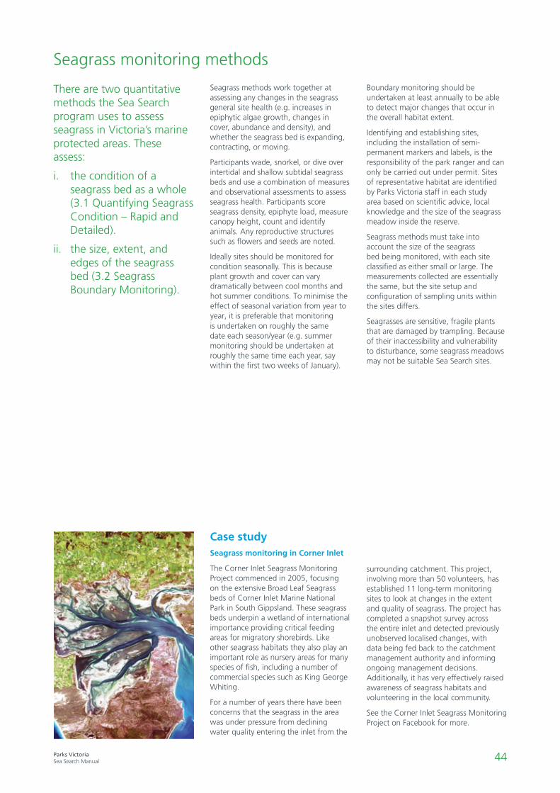
43
44
45
46
47
48
50
52
53
55
56
58
60
61
62
63
63
64
65
66
67
68
69
70
This symbol indicates a page intended for printing and to be taken to Sea Search activities - such as method sheets, data sheets and I.D. sheets. As well as appearing next to relevant pages in this table of contents, you will find this symbol in the top right corner of the pages themselves. These pages are available to download from the Sea Search website, or can be photocopied directly from this document.
Contents
90 Quality Control Guidelines
74
77
83
85
89

4Parks VictoriaSea Search Manual
5Parks VictoriaSea Search Manual
Introduction
Sea Search
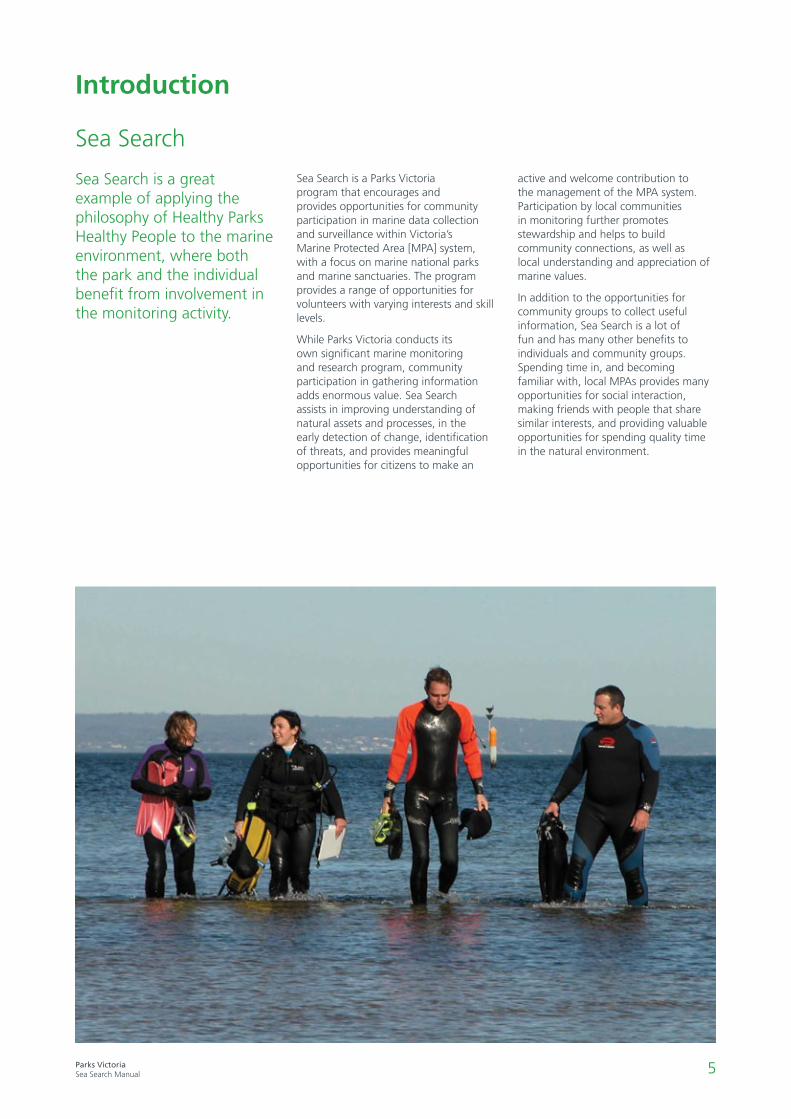
Sea Search is a great example of applying the philosophy of Healthy Parks Healthy People to the marine environment, where both the park and the individual benefit from involvement in the monitoring activity.
Sea Search is a Parks Victoria program that encourages and provides opportunities for community participation in marine data collection and surveillance within Victoria’s Marine Protected Area [MPA] system, with a focus on marine national parks and marine sanctuaries. The program provides a range of opportunities for volunteers with varying interests and skill levels.
While Parks Victoria conducts its own significant marine monitoring and research program, community participation in gathering information adds enormous value. Sea Search assists in improving understanding of natural assets and processes, in the early detection of change, identification of threats, and provides meaningful opportunities for citizens to make an
active and welcome contribution to the management of the MPA system. Participation by local communities in monitoring further promotes stewardship and helps to build community connections, as well as local understanding and appreciation of marine values.
In addition to the opportunities for community groups to collect useful information, Sea Search is a lot of fun and has many other benefits to individuals and community groups. Spending time in, and becoming familiar with, local MPAs provides many opportunities for social interaction, making friends with people that share similar interests, and providing valuable opportunities for spending quality time in the natural environment.
6Parks VictoriaSea Search Manual
Victorian marine environments
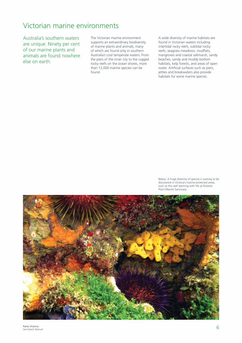
The Victorian marine environment supports an extraordinary biodiversity of marine plants and animals, many of which are found only in southern Australia’s cool temperate waters. From the piers of the inner city to the rugged rocky reefs on the ocean shores, more than 12,000 marine species can be found.
A wide diversity of marine habitats are found in Victorian waters including intertidal rocky reefs, subtidal rocky reefs, seagrass meadows, mudflats, mangroves and coastal saltmarsh, sandy beaches, sandy and muddy bottom habitats, kelp forests, and areas of open water. Artificial surfaces such as piers, jetties and breakwaters also provide habitats for some marine species.
Below: A huge diversity of species is waiting to be discovered in Victoria’s marine protected areas, such as this reef teeming with life at Ricketts Point Marine Sanctuary.
Australia’s southern waters are unique. Ninety per cent of our marine plants and animals are found nowhere else on earth.
7Parks VictoriaSea Search Manual
Marine protected areas
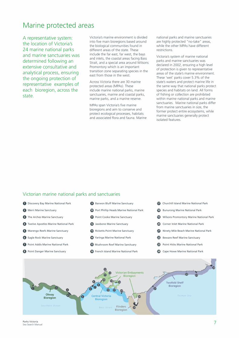
Victoria’s marine environment is divided into five main bioregions based around the biological communities found in different areas of the state. These include the far east, far west, the bays and inlets, the coastal areas facing Bass Strait, and a special area around Wilsons Promontory which is an important transition zone separating species in the east from those in the west.
Across Victoria there are 30 marine protected areas (MPAs). These include marine national parks, marine sanctuaries, marine and coastal parks, marine parks, and a marine reserve.
MPAs span Victoria’s five marine bioregions and aim to conserve and protect ecological processes, habitats and associated flora and fauna. Marine
national parks and marine sanctuaries are highly protected “no-take” areas, while the other MPAs have different restrictions.
Victoria’s system of marine national parks and marine sanctuaries was declared in 2002, ensuring a high level of protection is given to representative areas of the state’s marine environment. These ‘wet’ parks cover 5.3% of the state’s waters and protect marine life in the same way that national parks protect species and habitats on land. All forms of fishing or collection are prohibited within marine national parks and marine sanctuaries. Marine national parks differ from marine sanctuaries in size, the former protect entire ecosystems, while marine sanctuaries generally protect isolated features.
A representative system: the location of Victoria’s 24 marine national parks and marine sanctuaries was determined following an extensive consultative and analytical process, ensuring the ongoing protection of representative examples of each bioregion, across the state.
Discovery Bay Marine National Park
Merri Marine Sanctuary
The Arches Marine Sanctuary
Twelve Apostles Marine National Park
Marengo Reefs Marine Sanctuary
Eagle Rock Marine Sanctuary
Point Addis Marine National Park
Point Danger Marine Sanctuary
Barwon Bluff Marine Sanctuary
Port Phillip Heads Marine National Park
Point Cooke Marine Sanctuary
Jawbone Marine Sanctuary
Ricketts Point Marine Sanctuary
Mushroom Reef Marine Sanctuary
Yaringa Marine National Park
Churchill Island Marine National Park
French Island Marine National Park
Bunurong Marine National Park
Wilsons Promontory Marine National Park
Corner Inlet Marine National Park
Ninety Mile Beach Marine National Park
Beware Reef Marine Sanctuary
Point Hicks Marine National Park
Cape Howe Marine National Park
Victorian marine national parks and sanctuaries
1
2
3
4
5
6
7
8
179
1810
1911
2012
2113
2214
2315
2416
8Parks VictoriaSea Search Manual
Monitoring and management
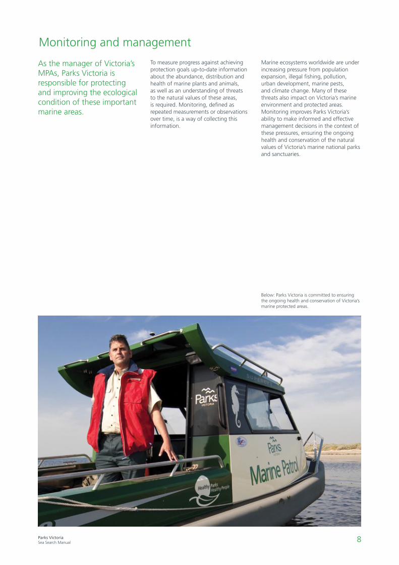
To measure progress against achieving protection goals up-to-date information about the abundance, distribution and health of marine plants and animals, as well as an understanding of threats to the natural values of these areas, is required. Monitoring, defined as repeated measurements or observations over time, is a way of collecting this information.
As the manager of Victoria’s MPAs, Parks Victoria is responsible for protecting and improving the ecological condition of these important marine areas.
Marine ecosystems worldwide are under increasing pressure from population expansion, illegal fishing, pollution, urban development, marine pests, and climate change. Many of these threats also impact on Victoria’s marine environment and protected areas. Monitoring improves Parks Victoria’s ability to make informed and effective management decisions in the context of these pressures, ensuring the ongoing health and conservation of the natural values of Victoria’s marine national parks and sanctuaries.
Below: Parks Victoria is committed to ensuring the ongoing health and conservation of Victoria’s marine protected areas.

9Parks VictoriaSea Search Manual
Table 1: A range of methods
Qualitative
Easy
Moderate
Difficult
Methods for all habitats
1.1Fixed Point
Photos
2.1
Cover quadrats (algae & invertebrates)
2.2Counting snails and other
mobile creatures
2.3 Catch per unit effort - snail and limpet sizes
1.2 Species Image
Library
1.3 Sea Search
Patrol
3.1.1 + 3.2.1 Quantifying seagrass
condition (rapid)
3.1.2 and 3.2.2 Quantifying seagrass condition (detailed)
3.3.1 and 3.3.3 Seagrass boundary
methods
Quantitative
Intertidal reef Seagrass(small and large sites)
A range of Sea Search methods
Sea Search is an inclusive program, where participants from all walks of life are encouraged to participate. Depending on interests, expertise, and access, volunteers can select from a range of monitoring tasks to undertake within their chosen marine national
park or marine sanctuary (Table 1). Note that methods rated as ‘Difficult’ are extensions to the preceding ‘Moderate’ methods, and are to be undertaken in conjunction with them (e.g. 2.3 must be done only in addition to 2.1 and 2.2, not by itself).
Quantitative activities occur either seasonally or annually, whilst qualitative activities can be undertaken at anytime. Your local Parks Victoria Ranger can assist in selecting appropriate monitoring tasks for your local MPA.
Easy: Can be done by new volunteers
Moderate: Can be done by volunteers with some experience and training
Difficult: Can be done by experienced volunteers with relevant training

10Parks VictoriaSea Search Manual
11Parks VictoriaSea Search Manual
SafetyHazards include: weather, waves, slippery surfaces, and potentially harmful marine creatures. However, with a little planning, all participants can enjoy a safe and comfortable Sea Search excursion.
It is the responsibility of each participant to ensure they are wearing the appropriate clothing and footwear for a planned activity. Shoes must be sturdy, with a solid sole, covered toes and good grip. Protection against the elements, such as a hat, sunscreen, sunglasses and water bottle are also important. If rain is predicted ensure adequate wet weather gear, such as a jacket or plastic poncho, and keep a change of warm, dry clothes just in case.
A current first aid kit must be at the monitoring site (all Parks Victoria rangers are first aid trained). Some form of communication, such as a mobile phone with good service, should be available to ensure that contact can be made with emergency services if required. Also ensure each participant has filled out a Parks Victoria volunteer form which includes emergency contact details as this is required for insurance purposes.
The safety of Sea Searchers visiting the coast is paramount. In planning for a monitoring excursion the sometimes challenging coastal environment must be considered.
While the best laid plans to undertake a survey are often done a long way ahead of time, the weather can throw a last minute spanner in the works, making what would have been a benign excursion into a high risk activity. The night prior to, and on the morning of a planned Sea Search activity, assess the weather forecast, tidal movement, and sea conditions. This can be done by checking the Bureau of Meteorology website.
Alternative dates for surveys, and a willingness to postpone activities, should be considered in the event of bad weather. Make sure the person organising the activity has all the participant’s contact details to update them if the event needs to be cancelled.
When on site ensure someone acts as a lookout for sudden large waves and changes in weather conditions.
A handy checklist of things to consider before, during and after each Sea Search activity has been included in the appendix of this document, and will help ensure the safety of all participants is provided for.
Getting started
Key safety messages for all participants:
Wear appropriate footwear that encloses and protects your feet at all times.
Don’t run - always walk carefully to avoid slipping or tripping.
Keep an eye on conditions - especially waves - never turn your back on the sea.
Don’t put your hands where you can’t see them to avoid potentially harmful marine creatures such as cone snails and blue-ringed
octopus.
Don’t handle cone shells and blue-ringed octopuses, or any other marine creature that you don’t recognise - even animals like
urchins, snails and anemones can irritate some people’s skin.
Don’t go too close to the edge of a rock platform, especially in rough conditions.
Always wear appropriate protective clothing. Slip, slop and slap in warmer weather; stay warm and dry in cooler weather.
Have a first aid kit available.
Bring a water bottle. Working in exposed environments can be dehydrating.
12Parks VictoriaSea Search Manual
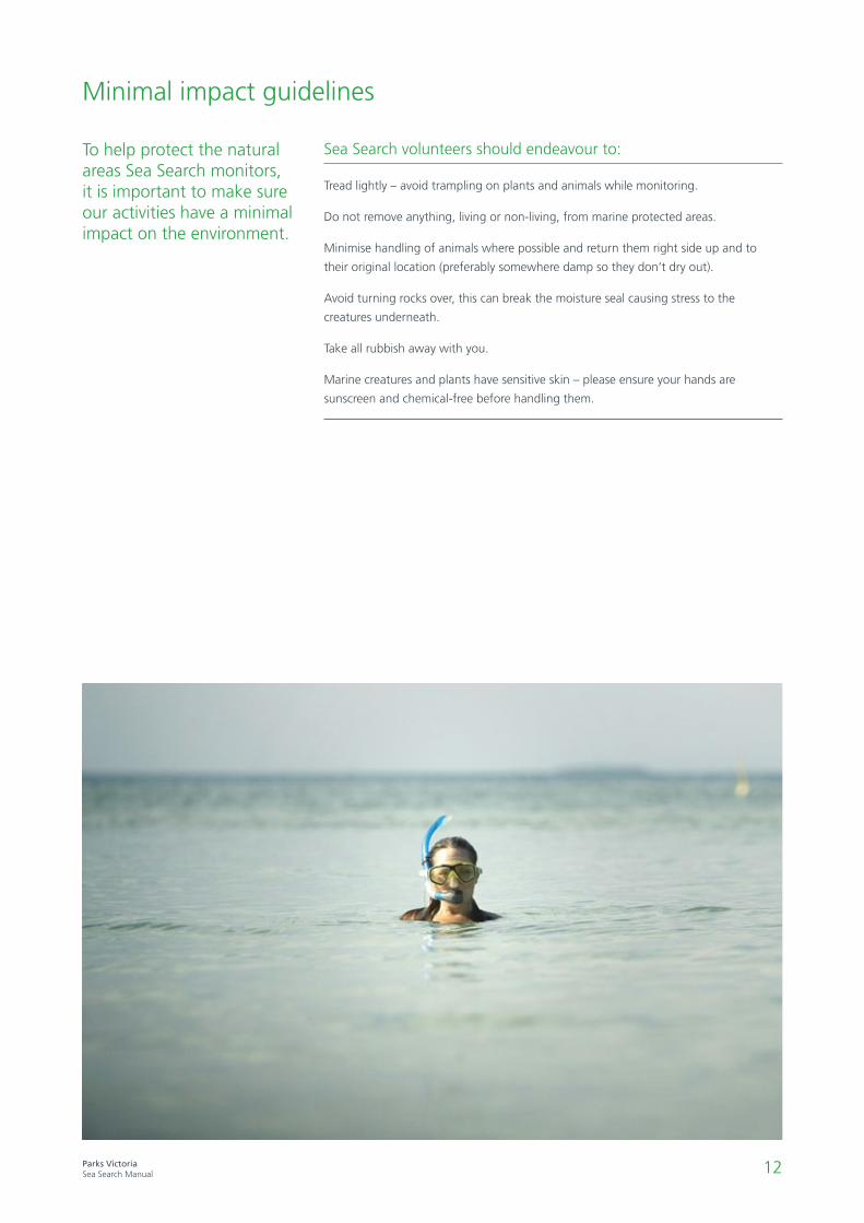
Minimal impact guidelines
To help protect the natural areas Sea Search monitors, it is important to make sure our activities have a minimal impact on the environment.
Sea Search volunteers should endeavour to:
Tread lightly – avoid trampling on plants and animals while monitoring.
Do not remove anything, living or non-living, from marine protected areas.
Minimise handling of animals where possible and return them right side up and to
their original location (preferably somewhere damp so they don’t dry out).
Avoid turning rocks over, this can break the moisture seal causing stress to the
creatures underneath.
Take all rubbish away with you.
Marine creatures and plants have sensitive skin – please ensure your hands are
sunscreen and chemical-free before handling them.
13Parks VictoriaSea Search Manual
Logistics
Sea Search is primarily focused on collecting data for Victoria’s marine national parks and marine sanctuaries. The program has already been established for some time at numerous locations along the Victorian coast. Contact your local Parks Victoria Ranger to connect with a Friends Group and find out when the next Sea Search activity is taking place.
If your local or favourite MPA is not currently being monitored through Sea Search, contact local Parks Victoria staff to help you establish a community group and start Sea Searching!
LocationTo contact a Parks Victoria Ranger for your marine national park or marine sanctuary, or other reserves, call 13 1963 and ask to be connected to the office associated with your chosen park. Alternatively, email your enquiries to [email protected]
The same approaches for marine monitoring can of course be applied at any suitable location along the coast outside MPAs. This manual provides useful techniques for communities to use; this could be in conjunction with other groups such as Coastcare). Data
for these other locations cannot however be uploaded to the Sea Search data base which is established for the exclusive collection and storage of information related to MPAs.
Complementary marine citizen science programs including Reefwatch and Reef Life Survey (see links in appendix) provide other community monitoring approaches than can also be applied across the entire coast, including within marine national parks and marine sanctuaries.
TimingSetting an appropriate date for monitoring must be done in consultation with a local tide chart (don’t forget to adjust for daylight savings) to ensure that the conditions will be suitable for the activity. Tide tables are developed many years in advance and are accessible from the Bureau of Meteorology’s website.
In general the best time for undertaking intertidal Sea Search activities is between two hours before and two hours after the predicted time of low tide. It is
however important to recognise that tides do vary in the extent to which they rise and fall and there are some low tides that will not suit surveys. Generally, if the tide is less than 0.4m it will be a good for an intertidal survey. However, in western Victoria locations such as Merri Marine Sanctuary, 0.2m is better.
Tide heights and movement are also important when undertaking seagrass methods. Subtidal seagrass surveys will be undertaken using diving and
snorkelling equipment, so it may be best to survey around slack water if the site is affected by tidal currents. Intertidal seagrass species are easier to survey at low tides.
Always discuss the timing of activities with your park ranger, who can inform you about local site conditions and help determine the best times to run a Sea Search activity.
FrequencyTypically, Sea Search methods have been designed to occur seasonally, i.e. 4 times per year. Seagrass boundary measurements can take place annually, whilst Species Image Library and Sea Search Patrol may occur opportunistically, at any time. Whether undertaking activities seasonally or annually, it is best to plan your Sea Search activities for the same time each season, or the same time each year, to
eliminate seasonal variations and obtain the most useful data and observations.
There can be seasonal effects on the distribution and types of animals and plants found on rocky or seagrass intertidal areas. Some seaweed, for example, grows in greater densities during spring, and dies back during summer. This is a natural seasonal variation. Over time it is important to identify this as a natural trend so it
isn’t confused with a disturbance, this is why regular and consistent seasonal monitoring is required.
Furthermore, observations by interested community members aid in the recognition of potentially threatening events (such as the presence of a marine pest); bringing them to a ranger’s attention will help ensure a timely response from the park manager should it be required.

14Parks VictoriaSea Search Manual
Being in the water is no excuse for not completing your data sheets! Rob here is a seasoned professional Sea Searcher.
Quality control
In addition to encouraging community participation in MPA management, the Sea Search program has the fundamental aim of providing data of sufficient quality to complement contracted scientific monitoring of Victoria’s MPAs. Sea search volunteers contribute significant time and effort in collecting data; it is therefore important to establish quality control measures that ensure this data is scientifically sound and able to be used.
Following a review of the program in 2012, Parks Victoria has improved Sea Search to make certain baseline quality control objectives are met, and ensure the validity of data.
Quality control improvements include:
The provision of a range of methods aimed at different skill levels
Clear, step-by-step instructions for monitoring methods
Regular training and refresher courses for facilitators and participants
Producing training videos
Having a roving quality control person appointed during difficult level monitoring activities
An improved database interface
Undertaking annual reviews of the program to ensure objectives are being met
The volunteers role in quality controlThe more accurate the information you collect, the better it is for helping understand our marine environment, detecting threats and changes, and helping contribute to managing it more effectively. To ensure your contribution to the Sea Search program is meaningful, it is worthwhile referring to the following guidelines.
Quality control guidelines for volunteers:
Read up and familiarise yourself with the methods before the day of a survey. If unsure how to implement any of the methods refer to the relevant video clip, or speak to your ranger.
Take step-by-step instructions with you when you go out into the field, and follow them closely. These are available on the Sea Seach website, and from your ranger on the day of an activity.
Make sure the GPS unit you are using is set to the correct format each time you go out, so you are coming back to the same (randomly assigned) quadrat sites each time. Note that Parks Victoria uses the WGS84 format displayed in Degrees, Minutes and Seconds.
Ensure all relevant data has been collected (i.e. datasheets should have no gaps). Check you have recorded a complete set of data before moving to the next quadrat, or the next method.
Have your partner check your data.
Enter data into the spreadsheet/database as soon as possible after the survey has been completed.
Keep up to date on species ID and take ID guides out into the field as necessary. To improve ID skills attend training courses where available and share your knowledge with others. If unsure about a species write a detailed description and take photos so your ranger can seek the advice of experts in marine taxonomy.
If you are unsure about anything ask your ranger.

15Parks VictoriaSea Search Manual
Equipment overview
All equipment required for undertaking Sea Search monitoring is available from your local ranger. Even if you are familiar with these tools, it is important to refresh yourself and check you are using them properly. Below is an explanation of some of the specific equipment used during Sea Search activities.
Identification guidesSpecies identification guides come in a number of formats, with different levels of detail. It is recommended to have a range on hand during monitoring activities to accurately identify the species you observe. Your ranger will have a number of guides, suitable to your location, available during each Sea Search activity.
Species identification sheets, including those specifically developed for Sea Search, provide a quick and easy visual reference to the more common species found in our MPAs. Multiple species appear on each side of the sheet, with a photograph, common name, and scientific name provided.
Identification field guides are also useful, usually having one or two species per page, with detailed information such as a photograph, tips for identification, range map, and a paragraph about habits of each species. Due to space restrictions these guides may only cover a broad grouping of plants or animals e.g. Invertebrates or cephalopods (octopus, cuttlefish and squid). Alternatively, they may cover a wider range of species types, but only within a limited geographic range, such as Port Phillip Bay.
Increasingly, identification guides are being developed as smartphone applications. These have the added benefit over traditional resources of allowing for audio and video content. Good examples of this type of identification guide are Museum Victoria’s ‘Field Guide to Victorian Fauna’, the ‘Bunurong Marine National Park Field Guide’ ( developed by Parks Victoria and Museum Victoria) and the ‘Barwon Bluff’ app developed by Friends of the Bluff in Barwon Heads. The ‘Port Phillip Bay Taxonomic Toolkit’ is another great online identification resource worth referring to if you are working in or near that region.
It is important to select guides that are applicable to your local area e.g. Port Phillip Bay, Victoria, or Southern Australia. A guide for Australia’s northeast coast species is no use on our temperate southern coast, however range expanding warm temperate species may soon become more common on Victoria’s eastern coast, where such a guide may prove more useful.
Below: The intertidal reef identification sheet provided in this manual being used by Sea Search volunteers at Mushroom Reef Marine Sanctuary.
16Parks VictoriaSea Search Manual
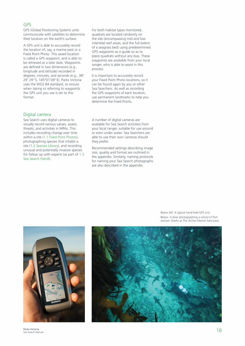
GPSGPS (Global Positioning System) units communicate with satellites to determine their location on the earth’s surface.
A GPS unit is able to accurately record the location of, say, a marine pest or a Fixed Point Photo. This saved location is called a GPS waypoint, and is able to be retrieved at a later date. Waypoints are defined in two dimensions (e.g., longitude and latitude) recorded in degrees, minutes, and seconds (e.g., 38° 29’ 29”S, 145°01’09”E). Parks Victoria uses the WGS 84 standard, so ensure when taking or referring to waypoints the GPS unit you use is set to this format.
For both habitat types monitored, quadrats are located randomly on the site (encompassing mid and low intertidal reef areas, and the full extent of a seagrass bed) using predetermined GPS waypoints as a guide so as to place quadrats without any bias. These waypoints are available from your local ranger, who is able to assist in this process.
It is important to accurately record your Fixed Point Photo locations, so it can be found again by you or other Sea Searchers. As well as recording the GPS waypoints of each location, use permanent landmarks to help you determine the Fixed Points.
Digital cameraSea Search uses digital cameras to visually record various values, assets, threats, and activities in MPAs. This includes recording change over time within a site (1.1 Fixed Point Photos), photographing species that inhabit a site (1.2 Species Library), and recording unusual and potentially invasive species for follow up with experts (as part of 1.3 Sea Search Patrol).
A number of digital cameras are available for Sea Search activities from your local ranger, suitable for use around or even under water. Sea Searchers are able to use their own cameras should they prefer.
Recommended settings describing image size, quality and format are outlined in the appendix. Similarly, naming protocols for naming your Sea Search photographs are also described in the appendix.
Below left: A typical hand-held GPS unit.
Below: A diver photographing a school of Port Jackson Sharks at The Arches Marine Sanctuary.
17Parks VictoriaSea Search Manual
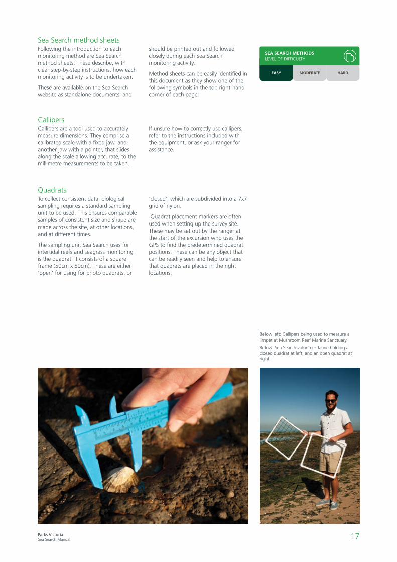
Below left: Callipers being used to measure a limpet at Mushroom Reef Marine Sanctuary.
Below: Sea Search volunteer Jamie holding a closed quadrat at left, and an open quadrat at right.
QuadratsTo collect consistent data, biological sampling requires a standard sampling unit to be used. This ensures comparable samples of consistent size and shape are made across the site, at other locations, and at different times.
The sampling unit Sea Search uses for intertidal reefs and seagrass monitoring is the quadrat. It consists of a square frame (50cm x 50cm). These are either ‘open’ for using for photo quadrats, or
‘closed’, which are subdivided into a 7x7 grid of nylon.
Quadrat placement markers are often used when setting up the survey site. These may be set out by the ranger at the start of the excursion who uses the GPS to find the predetermined quadrat positions. These can be any object that can be readily seen and help to ensure that quadrats are placed in the right locations.
CallipersCallipers are a tool used to accurately measure dimensions. They comprise a calibrated scale with a fixed jaw, and another jaw with a pointer, that slides along the scale allowing accurate, to the millimetre measurements to be taken.
If unsure how to correctly use callipers, refer to the instructions included with the equipment, or ask your ranger for assistance.
Sea Search method sheetsFollowing the introduction to each monitoring method are Sea Search method sheets. These describe, with clear step-by-step instructions, how each monitoring activity is to be undertaken.
These are available on the Sea Search website as standalone documents, and
should be printed out and followed closely during each Sea Search monitoring activity.
Method sheets can be easily identified in this document as they show one of the following symbols in the top right-hand corner of each page:
SEA SEARCH METHODSLEVEL OF DIFFICULTY
EASY MODERATE HARD
18Parks VictoriaSea Search Manual
19Parks VictoriaSea Search Manual
Methods for all habitats
Introduction
These methods can be used by community groups that undertake regular monitoring. Alternately, they can be undertaken by schools and other groups wishing to provide a focus or additional activities for their MPA visit. They are easy to learn and carry out, and do not require comprehensive training (though consultation with experts may be required to identify species captured in photographs).
Furthermore, timing and frequency of methods 1.2 Species Image Library, and 1.3 Sea Search Patrol, need not be seasonally restricted – observations and images may be collected opportunistically, at any time throughout the year.
Method 1.1 Fixed Point Photos are most useful if undertaken seasonally, with volunteers aiming to take photographs at the same time within each season. Each of these ’all habitat’ methods can be carried out separately or together, or in conjunction with intertidal reef and seagrass methods.
Habitats that may be of interest and that would be well suited to these methods include beaches, intertidal habitats such as soft sediments, rocky shores, mudflats, mangroves, coastal saltmarshes, and shallow subtidal habitats including rocky reefs and seagrass beds.
All methods can be undertaken from shore. Sea Search Patrols for marine pests, and photographing of subtidal marine species for the Species Image Library can also be done while snorkelling or SCUBA diving.
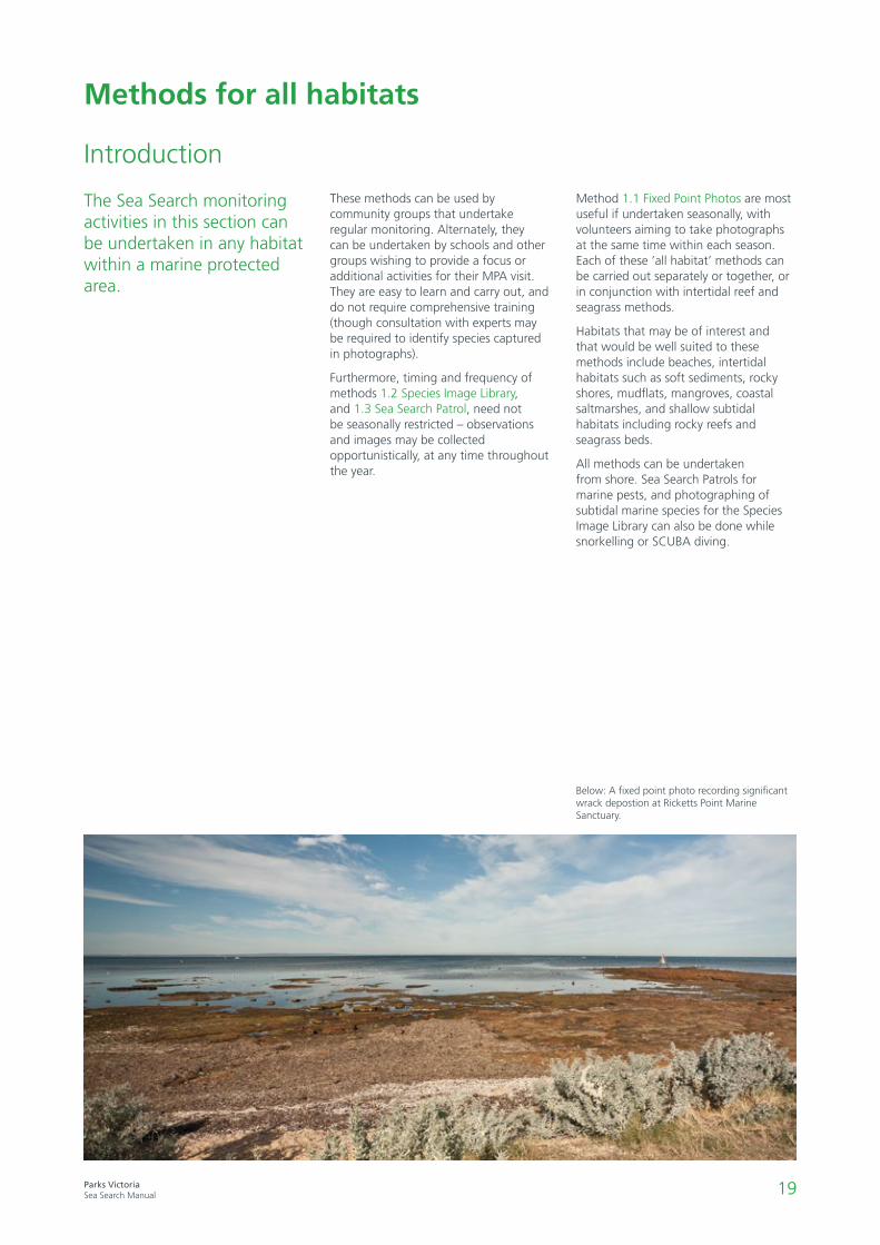
The Sea Search monitoring activities in this section can be undertaken in any habitat within a marine protected area.
Below: A fixed point photo recording significant wrack depostion at Ricketts Point Marine Sanctuary.

20Parks VictoriaSea Search Manual
1.1 Fixed point photos
What are the broad changes in habitats that occur over time within the marine national park or marine sanctuary?
Images of marine protected areas, taken from a fixed location, give a visual record of the park at that point in time. Repeated photos from these same locations over time are a valuable tool for detecting changes in the park, such as habitat area.
Images may illustrate seasonal and long-term variations such as algal extent, extent of seagrass, or the expansion of a mangrove forest. These areas may also change in response to human activity, invasion of exotic species, or even shifts in the climate.
Having this visual information enables managers to assess qualitatively whether habitats within MPAs are stable,
expanding, or contracting, and can therefore help identify severe changes and long term indicators of change.
Ideally, volunteers will undertake this method seasonally, that is 4 times per year. To minimise the effect of seasonal variation from year to year it is preferable that these photographs are taken on roughly the same date each season (e.g. summer photographs should be taken at roughly the same time each year, say within the first two weeks of January). In addition to these seasonal photographs, volunteers are encouraged to photograph significant events, such as wrack deposition, algal blooms, or pollution, as they occur - which may occur outside seasonal dates.
Case studyThe application of a fixed point photo series
The Fluker Post Project is a Victorian based initiative that uses fixed point photos to assist land and marine managers in detecting change over time in the environment. Where available they are great to use, assisting volunteers obtain accurate fixed point photos. Where not available, equally good results can be achieved provided volunteers accurately record the location and orientation of each photo point.
See www.flukerpost.com.au for more infomation.

21Parks VictoriaSea Search Manual
• Digital camera
• Clipboard and pencil
• Site datasheet
• GPS
• Compass
1.1Fixed point photos
Gear
1. At one or more sites choose a suitable vantage point on or adjacent to the shore and take a GPS recordingof your position. This is your fixed point that you return to each time you take photos at the site.Note the GPS waypoints on your site datasheet.
2. Decide on the main subject and field of view such that details of interest will be clearly seen in photoson this and future occasions.
3. Take a photograph of the subject, experimenting with the zoom and other relevant camera settingsnecessary to achieve clear and detailed photographs. Record these optimum photo settings on yoursite datasheet.
4. Record the direction of the middle of your photo as a compass bearing (degrees from North
where North is 0°) on your site datasheet so you know which direction to take the photo the
next time you visit.
Tip: minimise the amount of sky in your photo as this is not of interest.
Survey methods
1. Return to the exact same spot on a regular basis and use the same methods, exact compass bearings,and camera settings as used previously.
Return trips
SEA SEARCH METHODSLEVEL OF DIFFICULTY
EASY MODERATE HARD
22Parks VictoriaSea Search Manual
1. Download and clearly name photo(s) in .jpg format with location, photo number and date. For example, the firstimage you take from Barwon Bluff, on the 13th of April 2012, would be PV_BAR_2012_04_13_001.
2. Location names and their labelling codes are found in Appendix 1.
3. Upload data to APP/Online database or forward image files on USB and datasheets to the Park Ranger for filing and to look for changesthrough time.
• Include permanent landmarks in your photos if possible.
• Refer to these photos each time to make sure you take your next photo from the same place eachtime.
• Multiple sites may be used for larger marine national parks and marine sanctuaries.
Photo files and datasheets
Notes
SEA SEARCH METHODSLEVEL OF DIFFICULTY
EASY MODERATE HARD

23Parks VictoriaSea Search Manual
1.2 Species image library
What are the types of animals and plants that are found within the marine protected area?Are there any unusual species, such as marine pests or native range-expanders?
This method involves capturing images of all life forms in marine protected areas using digital cameras. Marine protected areas contain an abundance of plant and animal species, some of which are well known, but many of which are not. In order to better understand and conserve the biodiversity within protected areas, more information is needed. Your images will help document the diversity within parks and can assist in developing identification guides.
Photos of previously unknown species at a location may reflect the limited number of people that have explored the area, or may indicate that a new species has arrived. This may be important information for park management.
Volunteers are encouraged to log sightings of unusual and range expanding species on the interactive ‘Redmap’ website. Redmap stands for Range Extension Database and Mapping project. This project invites Australians to share sightings of marine species that are ‘uncommon’ to their local seas. Over time, Redmap will use this ‘citizen science’ data to map which Australian marine species may be extending their distribution range in response to changes in the marine environment such as ocean warming.
Photos of marine life can show others the unique marine life inhabiting Victoria’s cool water habitats and through raising awareness can assist in their protection.
Case studyHow a species library can develop
Friends of the Bluff are a community group associated with Barwon Heads, and the Barwon Bluff Marine Sanctuary. They have compiled an extensive species library over the years, from which they have been able to produce three guide booklets – Life on the Edge (intertidal marine life); Plants that Clothe the Bluff, and Birds of the Bluff .
Friends of the Bluff have now developed a smartphone application. This interactive app uses a smartphone’s inbuilt GPS to lead you around the Barwon Bluff and help you to identify, understand and appreciate this unique environment and the plants and animals that live there. Their extensive species library was integral to realising this initiative.
In addition to unwelcome introduced marine pests, marine species common in warmer waters along the east coast of Australia are being observed further south, most likely in response to climate change-related ocean warming and intensification of the East Australian Current (EAC).
Sea Search participants may be the first to record the presence of native species outside their previous natural range. Regular monitoring over time will help determine if their distribution is within the range of natural variability or indicative of a more recent geographic expansion. It is anticipated that in addition to Sea Search records, this information will be added to the database of the Redmap national program which maps changes in species distributions in response to climate change.
The introduction of exotic marine pests into Australian waters is a major environmental issue. Once established, marine pests are extremely difficult to eradicate so government strategies for dealing with pest species are largely focused on prevention, rather than control. Early detection of pest incursions however can assist with containment in certain circumstances, particularly when densities are low. Sea Search participants may be the first to raise the alarm if new pest species are appearing inside marine protected areas.

24Parks VictoriaSea Search Manual
1.2
Species image library
• Digital camera
• Note book and pencil
• Field identification guides
Gear
1. Take photos of any animal or plant that is of particular interest to you – even if you don’t know what it is.
If your ranger requires photos of particular species at your location they may provide you with a list of fish, invertebrates,
algae and seagrass species as a guide of what types of species to look for.
2. Take multiple photos from various angles as this helps with the identification (e.g. top, side, and underside).
3. Identify the subject in your photo using field identification guides. You can use scientific names or common
ones (e.g. Turbo undulatus or turban shell).
4. If you are unsure of the identity of your specimen, work with the Sea Search group and Parks Victoria
ranger to positively identify the specimen using identification guides and books.
5. If you cannot identify an animal or plant in the field write a description to go with your picture.
Where further confirmation of species identification is required, the ranger will follow up with experts.
6. Make notes of the location, date, species name and the person taking the photo.
Survey methods
Anywhere in your marine national park or marine sanctuary.
Where
For intertidal species go during predicted low tide. For subtidal species snorkel at mid-high tide.
Timing
1. Download and clearly name photos in .jpg format with location, habitat, date and species details.
For example, an image from Barwon Bluff of Turbo undulatus (Turban shell), on the rocky intertidal,
on the 13th of April 2012, would be PV_BAR_2012_04_13_Tund_rockyint.
2. Location names and their labelling codes are found in Appendix 1.
3. Upload image files to the APP/Online database, or forward image files on a USB and any
accompanying information onto the Park Ranger for filing and any necessary follow up with
experts.
Photo files
SEA SEARCH METHODSLEVEL OF DIFFICULTY
EASY MODERATE HARD
Most marine pests and native range expanders will be found in the shallow subtidal so the best chance of spotting them is by
snorkelling. Walks during low tide may also pick up these types of species especially lower on the shore and in rock pools.
Marine pests and native range expanders
Alert
If you see what you believe is a marine pest or native range expander in addition to a photo, write a description and record exact
location (and any habitat information) – DON’T REMOVE – and advise a Parks Victoria ranger as soon as possible.
25Parks VictoriaSea Search Manual
1.3 Sea Search patrol
What are the types of human activities and uses occurring within a marine protected area?
Are there any threats, such as pollution, litter, disturbance, affecting the marine protected area?
Are there changes in timing of reproduction by resident marine species?
Coastal and marine habitats are threatened by a range of human activities, marine pests, the arrival and establishment of warmer-water species, pollution and litter. Even in areas where regulations prohibit fishing, collection and disturbance, these activities may still occur. Marine protected areas can have high visitor numbers with people engaged in a range of activities, depending on the location and ease of access.
Gathering information on numbers of people within the park and what they are doing can help managers identify whether particular types of activities may be having a negative effect on resident plants and animals that could be addressed by changing management. For example, observing and reporting disturbance of wildlife by dogs, which particularly impacts on shorebirds and seabirds (e.g. the Hooded Plover), can lead to strategies to limit dog presence in the park.
Sea Search participants can make a valuable contribution to the conservation of marine protected areas through regular Sea Search surveillance patrols. Information recorded by observers can help identify potential threats at an early stage so that managers can take quick action. By being present you may also witness biological events (e.g. evidence of reproduction such as egg capsules, natural peaks in abundance) that tell us more about marine species and ecosystems.
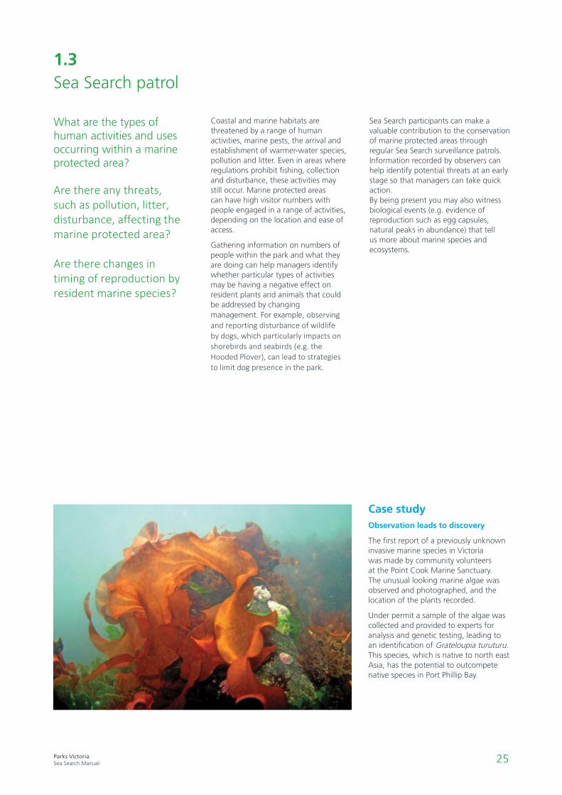
Case studyObservation leads to discovery
The first report of a previously unknown invasive marine species in Victoria was made by community volunteers at the Point Cook Marine Sanctuary. The unusual looking marine algae was observed and photographed, and the location of the plants recorded.
Under permit a sample of the algae was collected and provided to experts for analysis and genetic testing, leading to an identification of Grateloupia turuturu. This species, which is native to north east Asia, has the potential to outcompete native species in Port Phillip Bay.

26Parks VictoriaSea Search Manual
1.3
Sea Search patrol
• Clipboard and pencil
• Data sheets
• Digital camera (waterproof for snorkelling)
• Checklist of native marine migrants from the redmap website
• Feral and In Peril Reefwatch VIC guide (available online via Atlas of Living Australia)
Gear
The best time to do these surveys especially for human use information includes weekends, public holidays, school holidays, and good
weather (e.g. sunny days). If possible try to do your survey at the same time of day (between 1pm and 3pm is best) and or same low tide
period as previous surveys.
Timing
Across the entire marine national park or marine sanctuary, or at multiple sites within (make sure to record
where they are for future visits). Each time you visit try and cover a similar area.
Where
1. Do a walk or snorkel (about 30-60 minutes) covering as much of the area as possible.
2. Fill in the datasheet for each of the 3 impact types below and repeat each time you visit.
3. Take photos of examples of pollution, litter, or unknown species with your digital camera.
Survey methods
1. Do surveys when visibility is good (e.g. not pouring with rain) and note the time and tidal height – ideally making observations
at around the same (low) tide height each time.
2. On the datasheet record the activity of humans, dog presence and watercraft type including the approximate number of humans
engaging in particular activities, e.g. illegal fishing, fossicking, walking, surfing. If you observe illegal fishing, take a photo and call
13FISH.
Humans, dogs and watercraft
1. Do surveys when visibility is good (e.g. not pouring with rain) and note the time and tidal height – ideally making observations at around the
same (low) tide height each time.
2. On the datasheet record any signs of pollution such as litter, chemicals, or oil within the MPA. If you see obvious signs of chemicals, oil or
other substances in the vicinity contact Parks Victoria on 13 1963 or EPA on 1300 372 842.
3. Pollution and litter may also be noticed from a vantage point near the MPA if you walk by more frequently you can make records of this.
Pollution and litter
SEA SEARCH METHODSLEVEL OF DIFFICULTY
EASY MODERATE HARD

27Parks VictoriaSea Search Manual
SEA SEARCH METHODSLEVEL OF DIFFICULTY
EASY MODERATE HARD
Biological events can include sightings such as seals or dolphins offshore, lots of snail eggs, sea jellies (jelly fish)
in the water or washed up on the beach, flowering seagrasses and mangroves, or paper nautilus shells.
If you see something of biological interest then note these down and take a photo if you can.
Biological events
1. Check data sheets are complete.
2. Pack up gear.
3. Upload your data onto the APP/Online database – this should be entered as soon as possible.Alternatively, collate your data sheets and give them to the ranger who either enter the data or provide copies to volunteers forentering onto the database
Finishing up
1. Download and clearly name photos in .jpg format with location, habitat, and date.
For example, an image from Barwon Bluff, on the rocky intertidal, on the 13th of April 2012,
would be PV_BAR_2012_04_13_rockyint.
2. Location names and their labelling codes are found in Appendix 1
3. Upload image files to the APP/Online database or forward with any accompanying
information onto the Park Ranger for filing and any necessary follow up.
Photo files
1.

28Parks VictoriaSea Search Manual

29Parks VictoriaSea Search Manual
Intertidal reef monitoring
Introduction
Intertidal reefs can be made up of a variety of rock types and forms, upon which algae can attach, and where invertebrates may flourish. Reefs may be continuous sections of rock, or occur as areas covered by boulders or cobbles.
Exposed to air at low tide and covered by seawater at high tide, intertidal reefs support diverse and unique combinations of plants and animals that have evolved to survive in this dynamic environment. Birds make the most of the low tide to forage, while with the incoming tide nearby fish move onto the now submerged reef to feed and shelter.
Intertidal reefs in Victoria’s marine protected areas are home to numerous forms of brown, red and green algae; they cover the intertidal zone and provide habitats for many marine species as well as providing a source of food and nutrients.
Along with algae, some invertebrate animals such as mussels, barnacles, calcareous tube-building worms and ascidians (sea squirts) can also provide important habitat for other organisms. They trap water, provide microhabitats, and can repel or encourage other reef species to settle.
More species of algae grow at the lower edge of intertidal reefs than higher up the slope, as these areas may get too
hot and dry for most algae. Invertebrate animals that form dense covers can live higher up on the reef platform because they are protected from drying out by their waterproof shells, plates, or tubes.
Intertidal reefs are a great place for people to discover the fascinating marine life inhabiting the land-sea interface, but their popularity and exposure to human impacts can threaten the biodiversity of rocky shores. Human activities such as collection, fishing, trampling and rock turning can remove and injure animals and destroy the algal habitat on which they depend. Pollution, marine pests and climate change impacts (sea level rise, increased temperatures and altered seawater acidity) also threaten these habitats and organisms.
Regular Sea Search monitoring provides data that increases understanding of the natural variability of intertidal populations, provides valuable indications of change, and helps inform management decisions.
Field work should be done when low tide is predicted at 0.4 m or lower (0.2 or lower west of Apollo Bay). Participants should be on site around 1.5 - 2 hours before low tide. Ideally surveys should be completed before, or as, the tide comes in with participants leaving the reef well before sites are covered with water.
Intertidal reefs are the rocky areas between high and low tide, found in many of Victoria’s marine protected areas.
30Parks VictoriaSea Search Manual
Site setup
These zones loosely correspond with the duration for which they are exposed and covered during each tidal cycle, and by species interactions causing a dominance of particular species. The lower intertidal zone is only exposed to air on very low tides while the mid intertidal zone is regularly exposed and submerged by average tides. The upper intertidal zone is only covered by very high tides, but on shores exposed to large swells it is also influenced by waves and sea spray – meaning that the intertidal region canextend above the high tide line. While these general patterns are best observed on sloping rock platforms, in many cases these zones will be patchy and determined by the relative height of the reef at different locations.
Marine plants and animals are broadly distributed on intertidal reefs in 3 stratified ‘zones’.
Methods for Sea Search surveys are done in the mid intertidal zone and lower intertidal zone. In general, the mid intertidal is dominated by mussels, limpets, and snails, while the lower intertidal zone is dominated by larger brown algae, and invertebrate inhabitants such as Cunjevoi.
Surveys of intertidal areas rely on the use of quadrats to sample areas and make comparisons between sites. The locations of quadrats have been predetermined by Parks Victoria rangers and scientists. The location of each quadrat position is recorded using GPS way points.
New Sea Search surveys will require quadrat locations to be determined by Parks Victoria staff prior to commencing.
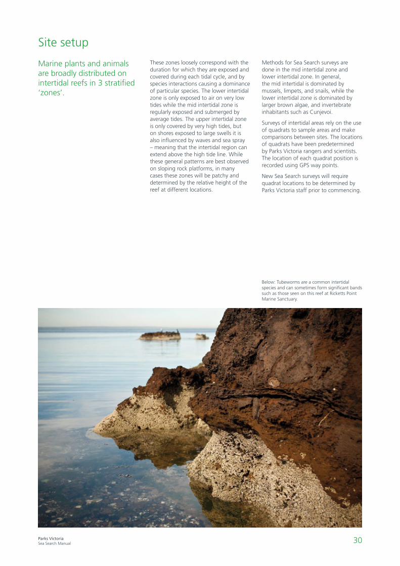
Below: Tubeworms are a common intertidal species and can sometimes form significant bands such as those seen on this reef at Ricketts Point Marine Sanctuary.

31Parks VictoriaSea Search Manual
2.1 Cover quadrats - algae and invertebrates
How does the cover of algae (especially the habitat forming species Hormosira banksii) vary in the marine protected area over time?
How does the cover of aggregating invertebrates (e.g. mussels, worms and barnacles) vary in the marine protected area over time?
Sea Search monitoring of intertidal algae and animal cover can help keep track of the health of rocky reef habitats. If changes in species composition and cover are determined to be beyond the limits of natural variation, further research and management intervention may be required.
Did you knowHow to mate when you’re stuck to a rock
Barnacles are sessile in their adult form, firmly cemented to a suitable substrate which requires them to catch their food from the water column with their feathery appendages. However before settling down they spend their youthful larval stages as free-swimming plankton. So why do adult barnacles cluster together on the rocky shore?
Barnacles need to fertilise each other internally, so minimising the distance between a potential mate is essential. Through detecting adults of their own species through chemical markers, mobile larvae seek out and affix themselves to existing colonies of barnacles, enabling them to mate. Hence the clusters of barnacles we see.
To further enhance breeding success barnacles have evolved the largest penis in proportion to body size in the animal world – up to 8 times its own body length! The enormous appendage is therefore able to blindly reach across the colony and deposit sperm in any receptive mates available.Photo: Chris Neufeld
32Parks VictoriaSea Search Manual
• GPS and quadrat placement map
• Quadrat placement markers
• Quadrats – 50cm x 50cm (use gridded quadrat for field
sampling or open quadrat for photo sampling). Two per 2-4
people.
• Site information sheet
• Photo labeller OR Printable labels for photo quadrats –
choose the labels with relevant location code
• Clipboard and pencil
• GPS
• Digital camera. One per 2-4 people.
2.1
Cover quadrats algae and invertebrates
Gear
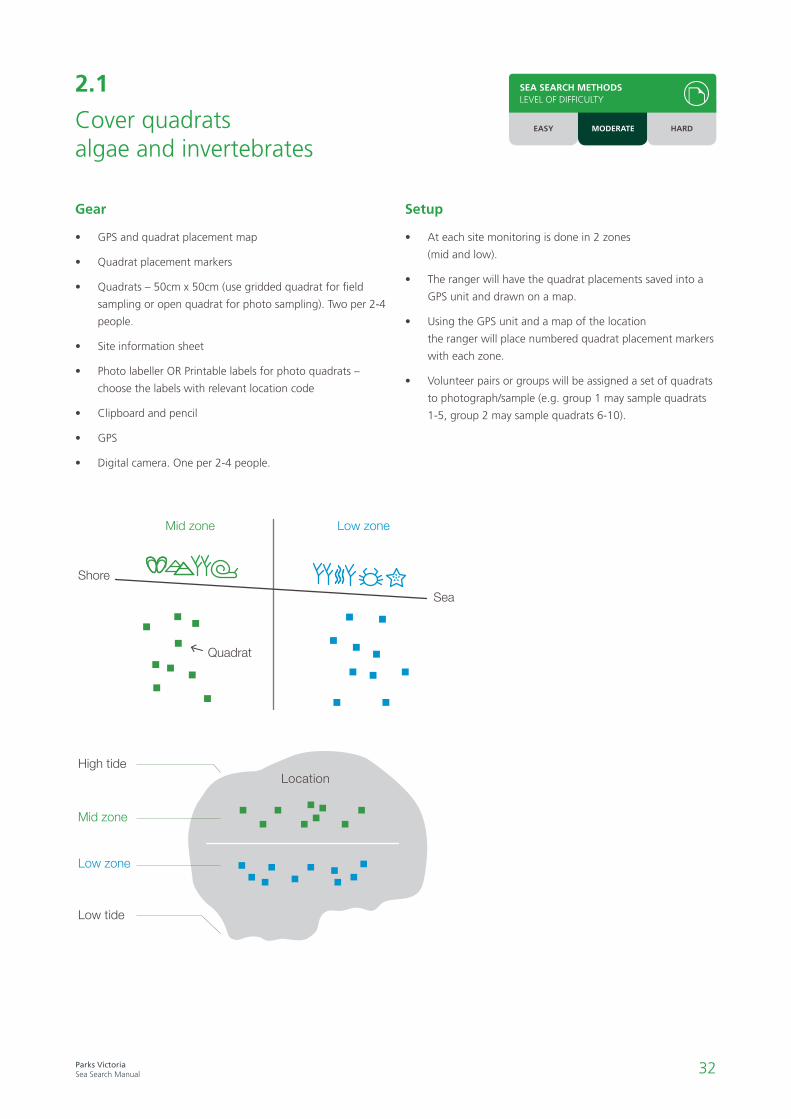
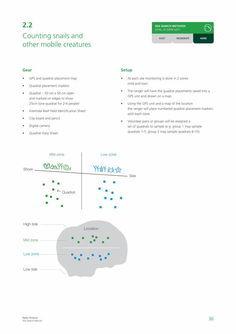
• At each site monitoring is done in 2 zones
(mid and low).
• The ranger will have the quadrat placements saved into a
GPS unit and drawn on a map.
• Using the GPS unit and a map of the location
the ranger will place numbered quadrat placement markers
with each zone.
• Volunteer pairs or groups will be assigned a set of quadrats
to photograph/sample (e.g. group 1 may sample quadrats
1-5, group 2 may sample quadrats 6-10).
Setup
High tide
Low tide
Mid zone
Low zone
Location
Mid zone Low zone
Shore
Sea
Quadrat
SEA SEARCH METHODSLEVEL OF DIFFICULTY
EASY MODERATE HARD
33Parks VictoriaSea Search Manual
SEA SEARCH METHODSLEVEL OF DIFFICULTY
EASY MODERATE HARD
1. Place a photo label inside the top left corner of the quadrat (being careful not to obstruct plants/animals).
Use Appendix 2: Photo quadrat labels protocol to produce a set of labels for your MPA.
2. Use a digital camera to take photos of the quadrat from directly above (where possible) while also minimising
shading in the frame. On sunny days, try to avoid glare.
3. Ensure that the edges of the quadrat can be seen in the frame and that the image is in focus.
Photos
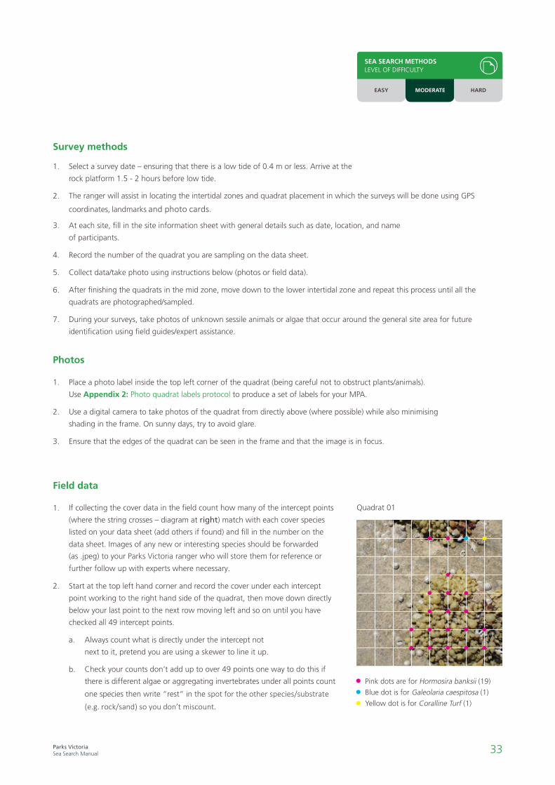
1. If collecting the cover data in the field count how many of the intercept points
(where the string crosses – diagram at right) match with each cover species listed on your data sheet (add others if found) and fill in the number on the data sheet. Images of any new or interesting species should be forwarded
(as .jpeg) to your Parks Victoria ranger who will store them for reference or
further follow up with experts where necessary.
2. Start at the top left hand corner and record the cover under each intercept
point working to the right hand side of the quadrat, then move down directly
below your last point to the next row moving left and so on until you have
checked all 49 intercept points.
a. Always count what is directly under the intercept not
next to it, pretend you are using a skewer to line it up.
b. Check your counts don’t add up to over 49 points one way to do this if there is different algae or aggregating invertebrates under all points count
one species then write “rest” in the spot for the other species/substrate(e.g. rock/sand) so you don’t miscount.
Field data
1. Select a survey date – ensuring that there is a low tide of 0.4 m or less. Arrive at the
rock platform 1.5 - 2 hours before low tide.
2. The ranger will assist in locating the intertidal zones and quadrat placement in which the surveys will be done using GPS
coordinates, landmarks and photo cards.
3. At each site, fill in the site information sheet with general details such as date, location, and name
of participants.
4. Record the number of the quadrat you are sampling on the data sheet.
5. Collect data/take photo using instructions below (photos or field data).
6. After finishing the quadrats in the mid zone, move down to the lower intertidal zone and repeat this process until all the
quadrats are photographed/sampled.
7. During your surveys, take photos of unknown sessile animals or algae that occur around the general site area for future
identification using field guides/expert assistance.
Survey methods
Quadrat 01
Pink dots are for Hormosira banksii (19)
Blue dot is for Galeolaria caespitosa (1)
Yellow dot is for Coralline Turf (1)

34Parks VictoriaSea Search Manual
1. At least one person in the volunteer group should be identified as the quality control person (this person
is likely experienced at the method, and familiar with the species).
2. This person should spot check between groups to make sure everyone is sampling and recording correctly (using the quality
control checklist) e.g. point intercept counts are accurate, quadrat isn't in rockpool, photos are clear and in focus.
3. One way of ensuring accuracy is for more than one person to count the species and intercept points
in each quadrat (from the same position) to make sure they both get the same count.
4. Either the quality control person or another group should check that all the information on the data sheet has been filled in
before the next quadrat is sampled.
Quality control
1. Check your cover data sheets are complete, collate and give them to the ranger who either enter the data
or provide copies to the volunteers for entering onto the Sea Search database.
2. Pack up gear.
Finishing up
1. Download and clearly name photos as .jpg with location, site and date details For example, an image from Barwon Bluff on the
13th of April 2012, mid intertidal zone, quadrat 4 would be PV_BAR_2012_04_13_BB_MQ4.
2. Location codes for labels are found in Appendix 1: Photograph naming protocols.
3. Forward image files on a USB onto the Park Ranger so they can be stored and talk with them about images you can help analyse.
Photo files
SEA SEARCH METHODSLEVEL OF DIFFICULTY
EASY MODERATE HARD

35Parks VictoriaSea Search Manual
2.2 Counting snails and other mobile creatures
How does the abundance of some key species of marine invertebrates change in the marine protected area over time?
Intertidal reefs in Victoria’s marine protected areas are home to unique cool-water species of mobile marine invertebrates such as marine snails, crabs, and sea stars. These mobile marine invertebrates are often the most conspicuous animals on intertidal reefs and can be found sheltering in algae and crevices, weathering the waves on rocks, and submerging themselves in rock pools.
Sea Search monitoring of common invertebrate species will enable managers to keep track of the health of rocky reef habitats. The abundance of mobile invertebrates may naturally rise and fall in response to pressures such as food availability, predation, or disturbance by storms. Monitoring over a number of years and seasons will
help determine if changes occurring in populations inside marine protected areas are within normal limits, or if they indicate that human impacts, such as fossicking and trampling of habitat, may be occurring. Monitoring may also show that an improvement or recovery is taking place. If changes in species populations are determined to be beyond the limits of natural variation, further research and management intervention may be initiated.
Surveys on the reef are done by counting the abundance of certain common snail and limpet species in 50 cm x 50 cm quadrats at sites within the marine protected area.
This activity should ONLY be done in conjunction with 2.1 Cover Quadrats; ensuring all quadrats are completed for that method, as this is the highest priority data.
Did you knowSalad bowls and gravy boats
By comparing the openings of different marine snail shells, you can see if they are carnivorous or herbivorous. If the opening is round and looks like a salad bowl, it is likely to be a herbivore. If the opening is long and has a small groove like a gravy boat, it is a carnivore.
36Parks VictoriaSea Search Manual
2.2
Counting snails and other mobile creatures
• GPS and quadrat placement map
• Quadrat placement markers
• Quadrat – 50 cm x 50 cm open
and marked on edges to show
25cm (one quadrat for 2-4 people)
• Intertidal Reef Field Identification Sheet
• Clip board and pencil
• Digital camera
• Quadrat Data Sheet
Gear
• At each site monitoring is done in 2 zones
(mid and low).
• The ranger will have the quadrat placements saved into a
GPS unit and drawn on a map.
• Using the GPS unit and a map of the location
the ranger will place numbered quadrat placement markers
with each zone.
• Volunteer pairs or groups will be assigned a
set of quadrats to sample (e.g. group 1 may sample
quadrats 1-5, group 2 may sample quadrats 6-10).
Setup
High tide
Low tide
Mid zone
Low zone
Location
Mid zone Low zone
Shore
Sea
Quadrat
EASY MODERATE HARD
SEA SEARCH METHODSLEVEL OF DIFFICULTY

37Parks VictoriaSea Search Manual
EASY MODERATE HARD
SEA SEARCH METHODSLEVEL OF DIFFICULTY
1. At least one person in the volunteer group should be identified as the quality control person
(this person is likely experienced at the method, and familiar with the species).
2. This person should spot check between groups to make sure everyone is sampling and recording correctly
(using the quality control checklist).
3. One way of ensuring accuracy is for more than one person to count the species
in each quadrat to make sure they both get the same count.
4. Either the quality control person or another group should check that all the information on the data sheet
has been filled in before the next quadrat is sampled.
Quality control
1. Check your cover data sheets are complete, collate and give to your Parks Victoria ranger who will either enter the
data or provide copies to the volunteers for entering onto an excel spreadsheet.
2. Pack up gear.
3. Collate your data sheets and give them to the ranger who either enter the data or provide copies to the
volunteers for entering onto an excel spreadsheet.
Finishing up
1. Download and clearly name photos as .jpg with location, site and date details For example, an image of an unknown species from
Barwon Bluff on the 13th of April 2012, mid intertidal zone, quadrat 4 would be PV_BAR_2012_04_13_MQ4_un.
2. Location codes for labels are found in Appendix 1: Photograph naming protocols.
3. Forward image files (on USB as .jpeg) onto the Park Ranger so they can assist you with identifications or follow
up with experts where necessary.
Photo files
1. Select a survey date – ensuring that there is a low tide of 0.4 m or less. Arrive at the rock platform 1.5 - 2 hours before low tide.
2. The ranger will assist in locating the intertidal zones and quadrat placement in which the surveys will be done using GPS
coordinates and landmarks.
3. At each site, fill in the site information sheet with general details such as date, location, and name of participants.
4. Record the number of the quadrat you are sampling on the data sheet.
5. Identify and count the number of animals in the quadrat as they appear on the data sheet1 and record this value.
• Take photos of unknown animals for future identification using field identification books or expert assistance.
• Do not count very small animals less than 4 mm shell length/height. Small animals are difficult to identify and are likely to
be recent arrivals, therefore it is more accurate to count older individuals to get an estimate of population abundance.
6. If there are very high numbers of one species (> 100 per quadrat), only count them in
one quarter of the quadrat (i.e. 25 x 25 cm area, see diagram at right). Multiply this
count by four and enter this number in the datasheet.
7. After finishing the quadrats in the mid zone, move down to the lower intertidal zone and
repeat this process until all the quadrats are sampled.
Survey methods
1 Volunteers survey specific species of marine snails and limpets commonly found in Victoria. If groups wish to select additional mobile invertebrates for monitoring they can be included on the data sheet and should be recorded in all future surveys. Additional species should be easy to identify, for example sea stars (e.g. Five-armed Cushion Star, Parvulastra exigua and the Eight-armed Cushion Star, Meridiastra calcar). Note that adding extra species to your data sheet is optional.
50cm
25cm

38Parks VictoriaSea Search Manual
2.3 Catch per unit effort – snail and limpet sizes
What is the size range of common species of gastropods inside marine protected areas, and how does this vary over time?Are the abundances and sizes of targeted and non-targeted species different?
Marine snails and limpets belong to a group of invertebrate animals known as gastropods (often referred to as marine snails). Gastropods are important in food webs, acting as prey for larger animals such as birds, fish and octopus, and influencing the types and amount of algae growing on rocky shores. Many species are herbivores, while others are predators or scavengers.
Because they move slowly most gastropods are easy to spot and capture, with some species taken as bait, for human consumption, or by shell collectors. Studies in Australia and overseas have shown that populations can be severely depleted by human collection and species may be permanently lost from an area. Loss of key gastropod species can have flow on effects on the intertidal reef leading to changes in the abundance or cover of other species.
In addition to being protected inside the boundaries of marine national parks and marine sanctuaries, all other gastropod such as abalone, snails, limpets and periwinkles are protected in the intertidal zone across Victoria, down to 2m depth. Collection of both live animals and shells is prohibited inside marine protected areas.
The abundance and sizes of intertidal gastropods may naturally vary through time and between places depending on the physical environment, and understanding this natural variability can help identify impacts that may occur. Comparing the size and abundance of gastropod species that are targeted (i.e. they are a preferred species for collection) to non-targeted species can help determine if gastropod populations are being impacted by human collection. If targeted snail species are found to be markedly smaller than previously and the control species at the same locations it may indicate poaching is taking place.
Ten minute searches are done for separate species of common gastropods in the intertidal zone of marine protected areas. This method focuses on gastropods that are known to be impacted by human collection, and compares them to ‘control’ (non-targeted) gastropods within the marine protected area. This gives us an estimate of how common a species is on the reef (as less common species will take longer to find than common species). Size measurements provide information about natural fluctuations in populations and a reference against which potential impacts can be measured.
Please note that 2.3 Catch per unit effort monitoring should only be undertaken following measures of cover and invertebrate abundance (2.1 and 2.2) as these provide the highest priority data.
Did you knowLimpet locomotion
Limpets are active foragers; when covered by water they move around feeding on the algae that grows on the surface of the rocks. To avoid desiccation on the exposed rock platform at low tide, limpets form a seal between their shell and the rock.
They can return to the exact same spot, over time wearing away a depression in the rock, known as a scar, which helps ensure a very tight seal.
39Parks VictoriaSea Search Manual
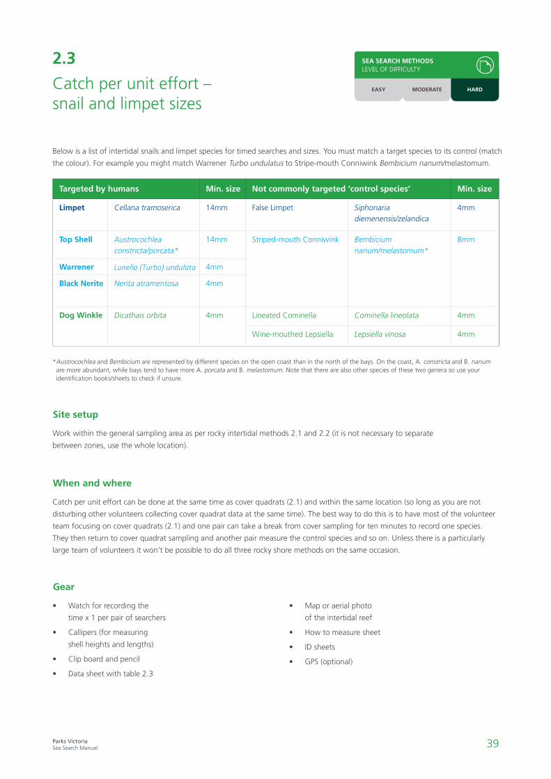
Below is a list of intertidal snails and limpet species for timed searches and sizes. You must match a target species to its control (match
the colour). For example you might match Warrener Turbo undulatus to Stripe-mouth Conniwink Bembicium nanum/melastomum.
* Austrocochlea and Bembicium are represented by different species on the open coast than in the north of the bays. On the coast, A. constricta and B. nanum are more abundant, while bays tend to have more A. porcata and B. melastomum. Note that there are also other species of these two genera so use your identification books/sheets to check if unsure.
2.3
Catch per unit effort – snail and limpet sizes
Work within the general sampling area as per rocky intertidal methods 2.1 and 2.2 (it is not necessary to separate
between zones, use the whole location).
Site setup
Catch per unit effort can be done at the same time as cover quadrats (2.1) and within the same location (so long as you are not
disturbing other volunteers collecting cover quadrat data at the same time). The best way to do this is to have most of the volunteer
team focusing on cover quadrats (2.1) and one pair can take a break from cover sampling for ten minutes to record one species.
They then return to cover quadrat sampling and another pair measure the control species and so on. Unless there is a particularly
large team of volunteers it won’t be possible to do all three rocky shore methods on the same occasion.
When and where
• Watch for recording the
time x 1 per pair of searchers
• Callipers (for measuring
shell heights and lengths)
• Clip board and pencil
• Data sheet with table 2.3
• Map or aerial photo
of the intertidal reef
• How to measure sheet
• ID sheets
• GPS (optional)
Gear
Targeted by humans Min. size Not commonly targeted ‘control species’ Min. size
Limpet Cellana tramoserica 14mm False Limpet Siphonaria diemenensis/zelandica
4mm
Top Shell Austrocochlea constricta/porcata*
14mm Striped-mouth Conniwink Bembicium nanum/melastomum*
8mm
Warrener Lunella (Turbo) undulata 4mm
Black Nerite Nerita atramentosa 4mm
Dog Winkle Dicathais orbita 4mm Lineated Cominella Cominella lineolata 4mm
Wine-mouthed Lepsiella Lepsiella vinosa 4mm
SEA SEARCH METHODSLEVEL OF DIFFICULTY
EASY MODERATE HARD
40Parks VictoriaSea Search Manual
1. At each site, fill in the site information sheet with details of date, time, weather, participants etc.
2. Species occupy different zones or heights on shore – have a look around first to see where species live and search in those zones
(not all species will be found at all locations).
3. From Table 2.3, establish which species occur at your location.
4. For each targeted species you choose to measure you must choose a control species (matched by colour in Table 2.3) to measure
(i.e. if you choose Cellana tramoserica you must choose one of Siphonaria diemenensis or Siphonaria zelandica – depending on
which is found at your site).
5. Work in pairs, if you have done this survey many times you may feel comfortable doing it solo.
6. In pairs – one person searches and measures the snails/limpets (check the minimum size for which you record in table) while the
other records and keeps track of time.
7. One species should be focused on for the 10 minute search period – you stop if you either reach 100 measurements or 10
minutes (this gives us a Catch Per Unit Effort).
8. Sizes – measure the shell heights or lengths of up to 100 individuals of each species using vernier callipers (see diagram below
for how to measure).
9. Only measure snails/limpets bigger than 4 mm, for Cellana and Austrocochlea only measure those bigger than 14 mm, for
Bembicium only measure snails bigger than 8mm (see table).
Survey methods
1. Check data sheets are complete.
2. Pack up gear.
3. Collate your data sheets and give them to the ranger who either enter the data or provide copies to the
volunteers for entering onto an excel spreadsheet.
Finishing up
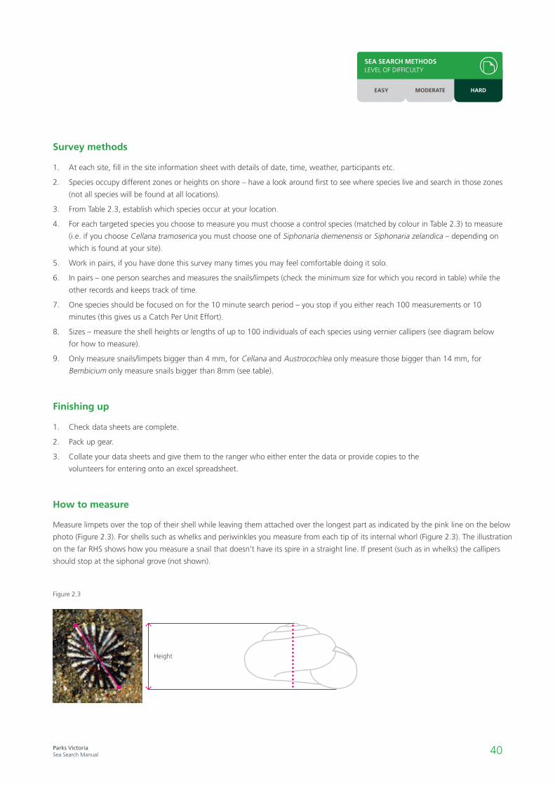
Measure limpets over the top of their shell while leaving them attached over the longest part as indicated by the pink line on the below
photo (Figure 2.3). For shells such as whelks and periwinkles you measure from each tip of its internal whorl (Figure 2.3). The illustration
on the far RHS shows how you measure a snail that doesn’t have its spire in a straight line. If present (such as in whelks) the callipers
should stop at the siphonal grove (not shown).
How to measure
Height
Figure 2.3
SEA SEARCH METHODSLEVEL OF DIFFICULTY
EASY MODERATE HARD
41Parks VictoriaSea Search Manual
42Parks VictoriaSea Search Manual

43Parks VictoriaSea Search Manual
Seagrass monitoring
Introduction
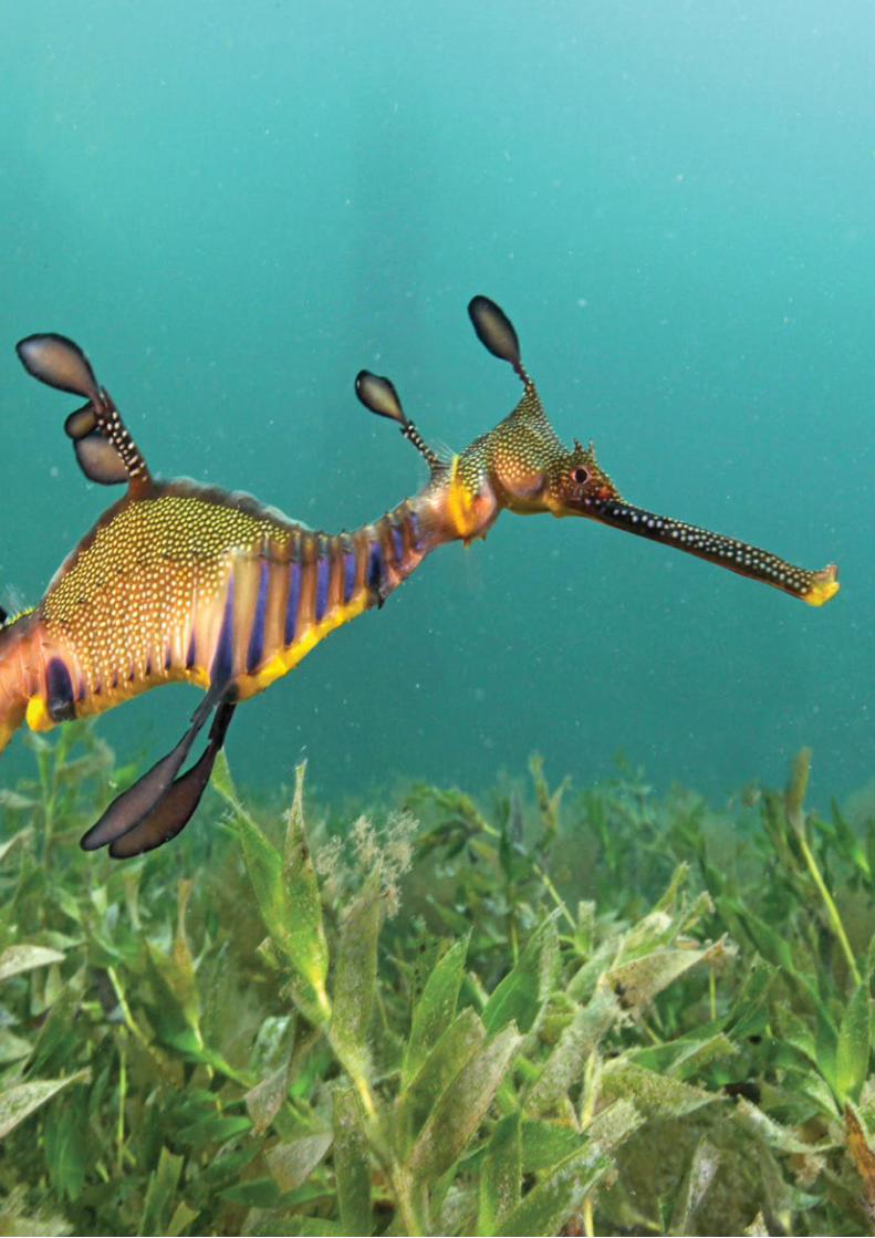
Most seagrass species are found in bays and inlets in sheltered conditions, but some species are found on open rocky coasts.
Seagrass species commonly encountered in the intertidal and shallow subtidal zones in Victoria include Zostera muelleri (Eelgrass - intertidal), Z. nigricaulis (Eelgrass- subtidal), Amphibolis antarctica (Wire Weed or Sea Nymph), Halophila australis (Paddle Weed), and only in Corner Inlet Posidonia australis (Broad-leaf Seagrass).
Seagrasses play a critical role in providing habitat for a wide range of species including many fish, a diverse range of invertebrates, as well as being an important feeding area for birds. Seagrasses play a key role in binding soft sediments and preventing coastal erosion. Many commercial and
recreational fisheries depend on healthy seagrass meadows because they are important nursery areas for young fish. They also play a role in nutrient cycling, producing oxygen and assimilating carbon from the atmosphere.
Throughout the world seagrass meadows are in decline, with implications for biodiversity and fisheries. Water quality is vital to the health of seagrasses and the many species of fish, birds, crustaceans and other invertebrates that depend upon them. Some of the threats to seagrass beds include suspended sediments and nutrients originating from the land and sea, coastal development, dredging, and physical damage from boat anchors, propellers or trampling. Marine pests, climate change, and overfishing also threaten seagrass habitats and the animals and plants that live within them.
Seagrasses are marine flowering plants that can form extensive beds which support a wide diversity of animals.
Below: Seagrass habitat (Amphibolis antarctica) within Bunurong Marine National Park.
44Parks VictoriaSea Search Manual
Seagrass monitoring methods
Seagrass methods work together at assessing any changes in the seagrass general site health (e.g. increases in epiphytic algae growth, changes in cover, abundance and density), and whether the seagrass bed is expanding, contracting, or moving.
Participants wade, snorkel, or dive over intertidal and shallow subtidal seagrass beds and use a combination of measures and observational assessments to assess seagrass health. Participants score seagrass density, epiphyte load, measure canopy height, count and identify animals. Any reproductive structures such as flowers and seeds are noted.
Ideally sites should be monitored for condition seasonally. This is because plant growth and cover can vary dramatically between cool months and hot summer conditions. To minimise the effect of seasonal variation from year to year, it is preferable that monitoring is undertaken on roughly the same date each season/year (e.g. summer monitoring should be undertaken at roughly the same time each year, say within the first two weeks of January).
There are two quantitative methods the Sea Search program uses to assess seagrass in Victoria’s marine protected areas. These assess:
i. the condition of aseagrass bed as a whole(3.1 Quantifying SeagrassCondition – Rapid andDetailed).
ii. the size, extent, andedges of the seagrassbed (3.2 SeagrassBoundary Monitoring).
Boundary monitoring should be undertaken at least annually to be able to detect major changes that occur in the overall habitat extent.
Identifying and establishing sites, including the installation of semi-permanent markers and labels, is the responsibility of the park ranger and can only be carried out under permit. Sites of representative habitat are identified by Parks Victoria staff in each study area based on scientific advice, local knowledge and the size of the seagrass meadow inside the reserve.
Seagrass methods must take into account the size of the seagrass bed being monitored, with each site classified as either small or large. The measurements collected are essentially the same, but the site setup and configuration of sampling units within the sites differs.
Seagrasses are sensitive, fragile plants that are damaged by trampling. Because of their inaccessibility and vulnerability to disturbance, some seagrass meadows may not be suitable Sea Search sites.
Case studySeagrass monitoring in Corner Inlet
The Corner Inlet Seagrass Monitoring Project commenced in 2005, focusing on the extensive Broad Leaf Seagrass beds of Corner Inlet Marine National Park in South Gippsland. These seagrass beds underpin a wetland of international importance providing critical feeding areas for migratory shorebirds. Like other seagrass habitats they also play an important role as nursery areas for many species of fish, including a number of commercial species such as King George Whiting.
For a number of years there have been concerns that the seagrass in the area was under pressure from declining water quality entering the inlet from the
surrounding catchment. This project, involving more than 50 volunteers, has established 11 long-term monitoring sites to look at changes in the extent and quality of seagrass. The project has completed a snapshot survey across the entire inlet and detected previously unobserved localised changes, with data being fed back to the catchment management authority and informing ongoing management decisions. Additionally, it has very effectively raised awareness of seagrass habitats and volunteering in the local community.
See the Corner Inlet Seagrass Monitoring Project on Facebook for more.

45Parks VictoriaSea Search Manual
3.1 and 3.2Quantifying seagrass condition
How does seagrass condition (cover, canopy height, epiphyte load) vary over time inside the marine protected area? What types of animals are found in seagrass beds, and how do the types and abundances of these animals vary over time?
Can indicators of seagrass reproduction be seen, and at what time of year do they appear? Is this consistent from year to year?
Seagrass density, along with canopy height, is an important measure of habitat health. Dense stands of healthy seagrass provide different habitat values to sparse or patchy seagrass. In addition to supporting biological diversity, dense seagrass is more effective at slowing currents than sparse meadows, making it a more effective buffer against tides and waves. We therefore measure both shoot numbers and length to get a picture of the habitat that is provided by the seagrass.
Algae commonly found growing on seagrass leaves are known as ‘epiphytes’ or ‘epiphytic algae’. Epiphytes are naturally occurring and provide food for a range of grazers, such as marine snails. Increased nutrients in the surrounding water from human sources, such as agriculture and sewage, may increase the growth of epiphytes beyond naturally-occurring levels, and may favour certain types of nutrient-loving epiphytes. An overabundance of epiphytes can impair and kill seagrass through smothering and blocking sunlight to leaves.
Many species of fish, crustaceans, bivalves, gastropods, and worms live on, amongst, and below seagrass shoots. Recording the animals living in the seagrass provides useful information about the types and abundances of seagrass inhabitants, and improves our understanding of the biodiversity protected in marine protected areas.
The Rapid and Detailed methods answer similar questions but with different degrees of confidence e.g. the rapid method (moderate difficulty) provides a snapshot of the condition and may alert us to large scale changes such as loss of seagrass and new marine pest species. The detailed condition (hard) measures seagrass condition explicitly so we can accurately determine percentage cover which in turn affects habitat structure.
The hard methods should only be undertaken following completion of their respective moderate methods; data collected in hard methods builds on that collected in moderate methods, rather than replaces it.
Below left: A Posidonia australis flower
Below: Using a quadrat to monitor subtidal seagrass condition.
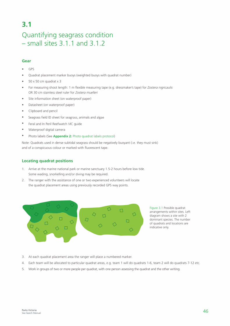
46Parks VictoriaSea Search Manual
1. Arrive at the marine national park or marine sanctuary 1.5-2 hours before low tide.
Some wading, snorkelling and/or diving may be required.
2. The ranger with the assistance of one or two experienced volunteers will locate
the quadrat placement areas using previously recorded GPS way points.
• GPS
• Quadrat placement marker buoys (weighted buoys with quadrat number)
• 50 x 50 cm quadrat x 3
• For measuring shoot length: 1 m flexible measuring tape (e.g. dressmaker’s tape) for Zostera nigricaulis
OR 30 cm stainless steel ruler for Zostera muelleri
• Site information sheet (on waterproof paper)
• Datasheet (on waterproof paper)
• Clipboard and pencil
•
•
Seagrass field ID sheet for seagrass, animals and algae
•
Feral and In Peril Reefwatch VIC guide
•
Waterproof digital camera
Photo labels (See Appendix 2: Photo quadrat labels protocol)
Note: Quadrats used in dense subtidal seagrass should be negatively buoyant (i.e. they must sink)
and of a conspicuous colour or marked with fluorescent tape.
3.1
Quantifying seagrass condition – small sites 3.1.1 and 3.1.2
Gear
Locating quadrat positions
Figure 3.1 Possible quadrat arrangements within sites. Left diagram shows a site with 2 dominant species. The number of quadrats and locations are indicative only.
3. At each quadrat placement area the ranger will place a numbered marker.
4. Each team will be allocated to particular quadrat areas, e.g. team 1 will do quadrats 1-6, team 2 will do quadrats 7-12 etc.
5. Work in groups of two or more people per quadrat, with one person assessing the quadrat and the other writing.

47Parks VictoriaSea Search Manual
SEA SEARCH METHODSLEVEL OF DIFFICULTY
EASY MODERATE HARD
1. Fill in the site information sheet, recording weather, time, location, participants etc.
2. Take a quadrat photo ensuring that the entire quadrat frame is in the field of view, that the photo label doesn’t obstruct the seagrass and take the picture as near vertical as possible (refer to notes on photo files later in this section). If it’s not possible to
get the entire quadrat in (e.g. Zostera nigricaulis in shallow water) in the photo, take a number of photos in a nearby deeper
area where it is possible. Sometimes photos of subtidal seagrass will not be possible.
3. Record the general sediment type in the centre of each quadrat.
Survey method
3.1.1
Rapid method – small sites
4.
5. Note any flowers or reproductive structures that might be present in or around the whole site (see identification sheet).
7. Record sightings of any marine pests (using the Feral and In Peril Guide), indications of disturbance or dieback, or other
interesting biological observations. Note that some introduced species such as the Asian date mussel Musculista senhousia are
usually buried in fine sediment.
8. If time permits, you can also take photos of the general site area for future reference.
Sediment type Description
Mud Smooth and sticky texture
Fine sand Fairly smooth texture with some roughness just detectable
Sand Rough grainy texture, particles clearly distinguishable
Coarse sand Coarse texture, particles loose
Gravel Very coarse texture, with some small stones
Record percentage cover (0 - 100%) of each seagrass species (see ID sheet), algae (not epiphytes), bare sediment or any other habitat type in the quadrat. When added together these should come to 100%.
6. Determine the percentage cover of epiphytes. The percentage cover of epiphytic algae is measured by estimating “thepercentage of total surface area of leaves covered by algal growth”. Note that this is separate to the seagrass cover and doesn'tneed to add up to 100%.
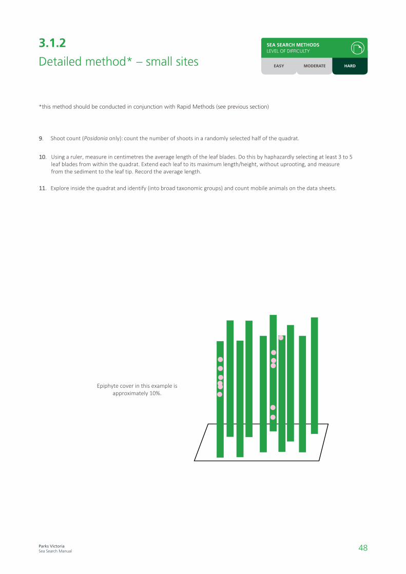
48Parks VictoriaSea Search Manual
Front Back
3.1.2
Detailed method* – small sites
11.
9.
*this method should be conducted in conjunction with Rapid Methods (see previous section)
What percentage ofthe levels have someepiphtye on them?
Look at all leaves
10.
SEA SEARCH METHODSLEVEL OF DIFFICULTY
EASY MODERATE HARD
Explore inside the quadrat and identify (into broad taxonomic groups) and count mobile animals on the data sheets.
Shoot count (Posidonia only): count the number of shoots in a randomly selected half of the quadrat.
Using a ruler, measure in centimetres the average length of the leaf blades. Do this by haphazardly selecting at least 3 to 5 leaf blades from within the quadrat. Extend each leaf to its maximum length/height, without uprooting, and measure from the sediment to the leaf tip. Record the average length.
Epiphyte cover in this example is approximately 10%.

49Parks VictoriaSea Search Manual
SEA SEARCH METHODSLEVEL OF DIFFICULTY
EASY MODERATE HARD
1. Check that your data sheets are complete.
2. Pack up gear.
3. Collate and give your completed data sheets to the Parks Victoria ranger who will store and make copies for volunteers to help enter the data onto the Sea Search database.
4. All gear should be washed thoroughly in freshwater and dried before storing
1. Download and clearly name photos as .jpg with location, quadrat number and date details.
For example, an image from Jawbone on the 13 April 2012, at quadrat 4 would be 2012_04_13_Q4_J.
2. Location codes for labels are found in Appendix 1: Photograph naming protocols.
3. Upload images onto the APP/Online database. Alternatively, forward image files (saved as .jpeg on USB) to the Park
Ranger so they can be stored and talk with them about how you can help analyse images.
• If the quadrat is flattening seagrass leaves (e.g. when underwater), gently free where practical so that any assessments are made
of upright leaves originating from within the quadrat.
• Avoid stepping in the quadrat, and minimise movement in the surrounding area to reduce sediment re-suspension and seagrass
damage. Working down current will also help prevent sediment re-suspension (which can make measurements more difficult).
Finishing up
Photo files
Notes

50Parks VictoriaSea Search Manual
3.2
Initial site setup for quantifying seagrass condition – large sites
1. Record site coordinates with a GPS and write down these details in the site information sheet.
2. Sites are positioned at the same depth in continuous or separate seagrass meadows.
3. Sites may be marked with a small subsurface buoy or fluorescent flagging tape attached to a plastic stake/star picket driven
down flush with the sediment.
4. Ensure all gear lies close to the seafloor to avoid entanglement with boat anchors or other equipment.
5. Attach the site label (Figure 3.2) to the star picket with a plastic cable tie so that it sits on the sediment/seagrass.
• GPS
• Plastic star picket – 1 per site
• Small subsurface buoys – 1 per site
• Site labels (e.g. plastic cattle tags marked as “property of Parks Victoria, site number, and research permit number” where
applicable) and UV resistant cable ties
• Site information sheet (on waterproof paper)
Gear
Setup method
Green dots representhaphazardly- deployed weightedlines to assist withquadrat placement
Centre of site markedwith GPS andpermanentmarker wherefeasible
Six pairs of quadrats randomly orientatedwith respect to central GPS marker(orange dot).
MNPboundary
> 20m between sites
Site 20 m x 20 m approx.
Figure 3.2 Large site set up: red dot indicates permanent marker/centre of site, squares indicate quadrat placement for sampling.
Initial site selection and set up is undertaken by the Parks Victoria Research Section in collaboration with rangers and is done on a
separate day prior to a Sea Search sampling event.

51Parks VictoriaSea Search Manual
3.2
Quantifying seagrass condition – large sites 3.2.1 and 3.2.2
1. Locate sites using a GPS. If possible sites will be marked with permanent subsurface buoys which may not be visible from the
surface.
2. Haphazardly deploy 6 weighted surface marker buoys within a 20 m x 20 m area around the GPS point/site marker. These
surface marker buoys will identify quadrat pair locations.
3. Working in pairs, place 2 quadrats (50 cm x 50 cm) on the substrate at the base of each marker.
• GPS
• Weighted surface buoys on 3-4 m of thin rope to mark quadrat points x 6
• 50 x 50 cm quadrats – 2 per quadrat point
• Site information sheet (on waterproof paper)
• Seagrass datasheet (Rapid or Detailed) – 1 per recorder (on waterproof paper)
• Clipboard and pencil – 1 per recorder
• Waterproof digital camera
• Table 3.2 – substrate type
• Seagrass field ID sheet for animals, seagrass and algae
• Feral and In Peril Reefwatch VIC guide
• Photo labels (See Appendix for examples)
• Tools for measuring water quality parameters such as N, P, pH and temperature (optional)
• Secchi disc (optional)
Note: Quadrats used in dense subtidal seagrass should be negatively buoyant (i.e. they must sink) and of a conspicuous colour
or marked with fluorescent tape.
Gear
Locating sites and quadrat positions
Figure 3.3 Random site design for Sea Search seagrass monitoring, ideally suited for large subtidal seagrass beds.
Green dots representhaphazardly- deployed weightedlines to assist withquadrat placement
Centre of site markedwith GPS andpermanentmarker wherefeasible
Six pairs of quadrats randomly orientatedwith respect to central GPS marker(orange dot).
MNPboundary
> 20m between sites
Site 20 m x 20 m approx.
52Parks VictoriaSea Search Manual
SEA SEARCH METHODSLEVEL OF DIFFICULTY
EASY MODERATE HARD
3.2.1
Rapid method – large sites
1. Fill in the site information sheet, recording weather, time, location, participants etc.
2. Take a quadrat photo ensuring that the entire quadrat frame is in the field of view, that the photo label doesn’t obstruct the
seagrass and take the picture as near vertical as possible (refer to notes on photo files later in this section). If it’s not possible
to get the entire quadrat in (e.g. Z. nigricaulis in shallow water) in the photo, take a number of photos in a nearby deeper area
where it is possible. Sometimes photos of subtidal seagrass will not be possible.
3. Record the general sediment type in the centre of each quadrat.
Survey method
4.
5. Note any flowers or reproductive structures that might be present in or around the whole site (see identification sheet).
7. Record sightings of any marine pests (using the Feral and In Peril Guide), indications of disturbance or dieback, or other
interesting biological observations. Note that some introduced species such as the Asian date mussel Musculista senhousia are
usually buried in fine sediment.
8. If time permits, you can also take photos of the general site area for future reference.
Sediment type
Mud
Description
Smooth and sticky texture
Fine sand Fairly smooth texture with some roughness just detectable
Sand Rough grainy texture, particles clearly distinguishable
Coarse sand Coarse texture, particles loose
Gravel Very coarse texture, with some small stones
Record percentage cover (0 - 100%) of each seagrass species (see ID sheet), algae (not epiphytes), bare sediment or any other habitat type in the quadrat. When added together these should come to 100%.
6. Determine the percentage cover of epiphytes. The percentage cover of epiphytic algae is measured by estimating “thepercentage of total surface area of leaves covered by algal growth”. Note that this is separate to the seagrass cover and doesn'tneed to add up to 100%.

53Parks VictoriaSea Search Manual
What pe rcentage ofthe levels have someepiphtye on them?
Look at all leaves
Front Back
3.2.2
Detailed method* – large sites
*this method should be conducted in conjunction with Rapid Methods (see previous section)
SEA SEARCH METHODSLEVEL OF DIFFICULTY
EASY MODERATE HARD
Epiphyte cover in this example is approximately 10%.
11.
9.
10.
Explore inside the quadrat and indentify (into broad taxonomic groups) and count mobile animals on the data sheets.
Shoot count (Posidonia only): count the number of shoots in a randomly selected half of the quadrat.
Using a ruler, measure in centimetres the average length of the leaf blades. Do this by haphazardly selecting at least 3 to 5 leaf blades from within the quadrat. Extend each leaf to its maximum length/height, without uprooting, and measure from the sediment to the leaf tip. Record the average length.
54Parks VictoriaSea Search Manual
1. Check all datasheets are complete.
2. Pack up gear.
3. Collate and give your completed data sheets to the Parks Victoria ranger who will store and make copies for volunteers to help enter the data onto the Sea Search database.
4. All gear should be washed thoroughly in freshwater and dried before storing.
1. Download and clearly name photos as .jpg with location, site and date details. For example, an image from Corner Inlet on the
13 April 2012, at site 1, quadrat 4 would be 2012_04_13_S1Q4_CI.
2. Location codes for labels are found in Appendix 1: Photograph naming protocols.
3.
• If the quadrat is flattening seagrass leaves (e.g. when underwater), gently free where practical so that any assessments are made
of upright leaves originating from within the quadrat.
• Avoid stepping in the quadrat, and minimise movement in the surrounding area to reduce sediment re-suspension and seagrass
damage. Working down current will also help prevent sediment re-suspension (which can make measurements more difficult).
Finishing up
Photo files
Notes
At each site other physical parameters may be recorded including turbidity (Secchi disc), water temperature (dive computer/
measuring tool) and nutrient levels (measuring tool). This information should be recorded on the site information sheet.
Site information
SEA SEARCH METHODSLEVEL OF DIFFICULTY
EASY MODERATE HARD
All Images should be uploaded to the APP/Online database. Alternatively, forward image files (saved as .jpeg on USB) to the ParkRanger so they can be stored and talk with them about how you can help analyse images.

55Parks VictoriaSea Search Manual
3.3Seagrass boundary monitoring
Are the seaward and landward boundaries of the seagrass meadow expanding or contracting?
Is the direction of change constant, or is it variable (i.e. some years advancing landwards, some years retreating)?
Are species zones moving? e.g. are subtidal species (Zostera nigricaulis) moving landward? (This a potential indicator of sea level rise or change in water clarity).
Seagrasses create habitats for a range of species, sequester carbon, stabilise sediments, and are primary producers. The size of seagrass beds is influenced by natural processes such as seasonality, light availability, water depth, sediments and hydrodynamics, but it can also be affected by impacts such as water pollution (including turbidity), physical disturbance (e.g. trampling, anchor scar) and sediment burial (e.g. run-off).
Different seagrass species may naturally be found at different depths but a reduction in the amount of light penetrating the water may alter their distribution. Light can be blocked by sediments in the water from land runoff or dredging (turbidity) or overgrowth of some nutrient-loving algae (epiphytes) in response to excess nutrients from agriculture and sewage. Damage to seagrass beds can occur as a decline in overall growth or even death of entire areas, retreat of boundaries, and fragmentation.
Sea Searchers measure the distance of the inner and outer edges of the seagrass meadow from a fixed point. Monitoring the deep and shallow boundaries of seagrass meadows over time can show whether a seagrass meadow is expanding, contracting, or moving; and so provide a measure of seagrass extent inside marine protected areas. Monitoring the movement of species dominance (e.g. Zostera nigricaulis expanding shoreward into areas previously dominated by Zostera muelleri) across the seagrass bed can also tell us about changes to local hydrology and possibly sea level rise.
This method should be conducted annually within the same season each year.
Left: A clearly defined seagrass boundary.

56Parks VictoriaSea Search Manual
3.3.1
Seagrass boundary monitoring – small sites (<100 m only)
• GPS
• Compass
• Short plastic star picket x 3
• Pegs for staking end of measuring tapes x 6
• Dive slate and pencil and rubber bands for securing data sheets
• Data sheet – 1 per site (on waterproof paper)
• Site information sheet (on waterproof paper)
• Waterproof digital camera
• 50 m or 100 m transect tape x 3
Gear
1. Fill in the site information sheet.
2. Starting with the shallow edge, locate transect 1 (T1). If no permanent marker is present, relocate the point using GPS, maps
and land or navigational features and mark with a plastic peg.
3. Measure the distance (seaward/landward, Figure 3.4) from the shallow edge marker to the first leaf; and the point where an
adult hand placed flat on the sediment touches at least two separate plant parts. Make sure you follow the same compass
bearing as for previous surveys.
a. If the stake is now outside the seagrass bed indicate this on the datasheet.
1. Parks Victoria rangers will establish 3 fixed points near the deep and 3 fixed points near the shallow boundaries of the seagrass
meadow which will be marked by GPS waypoints.
2. 3 transects that run from deep markers to shallow markers will be used for sampling, the direction these transects run will be
recorded as a compass bearing.
3. Fixed points near the deep boundary can be marked by a small subsurface buoy or fluorescent flagging tape attached to a
plastic star picket driven down flush with the sediment to allow future relocation.
4. Any subsurface gear should lie close to the seafloor to avoid entanglement with boat anchors or other equipment and have a
label identifying the gear as the property of Parks Victoria.
Survey methods
Initial site setup (this can be done on the first survey but only needs to be done once)
SEA
Shallow edge marker
Specieschange
Deep edgemarker
Seagrass boundary
Permanent deep marker
(a) Seagrass landwards from deep marker (b) Seagrass seaward past deep marker
T1
T2
T3
LAND
SEA
LAND
Figure 3.4 Diagram showing seagrass moving landwards (a) or seawards (b) past permanent marker. When revisiting the site to measure seaward boundary, record (a) as # m seaward and (b) as # m landward.
SEA SEARCH METHODSLEVEL OF DIFFICULTY
EASY MODERATE HARD
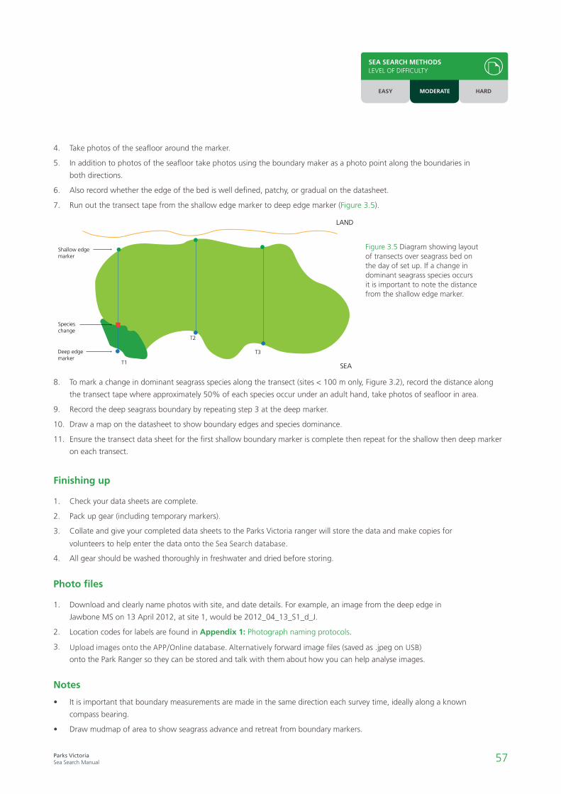
57Parks VictoriaSea Search Manual
SEA SEARCH METHODSLEVEL OF DIFFICULTY
EASY MODERATE HARD
8. To mark a change in dominant seagrass species along the transect (sites < 100 m only, Figure 3.2), record the distance along
the transect tape where approximately 50% of each species occur under an adult hand, take photos of seafloor in area.
9. Record the deep seagrass boundary by repeating step 3 at the deep marker.
10. Draw a map on the datasheet to show boundary edges and species dominance.
11. Ensure the transect data sheet for the first shallow boundary marker is complete then repeat for the shallow then deep marker
on each transect.
1. Check your data sheets are complete.
2. Pack up gear (including temporary markers).
3. Collate and give your completed data sheets to the Parks Victoria ranger will store the data and make copies for
volunteers to help enter the data onto the Sea Search database.
4. All gear should be washed thoroughly in freshwater and dried before storing.
Finishing up
1. Download and clearly name photos with site, and date details. For example, an image from the deep edge in
Jawbone MS on 13 April 2012, at site 1, would be 2012_04_13_S1_d_J.
2. Location codes for labels are found in Appendix 1: Photograph naming protocols.
3. Upload images onto the APP/Online database. Alternatively forward image files (saved as .jpeg on USB)
onto the Park Ranger so they can be stored and talk with them about how you can help analyse images.
Photo files
• It is important that boundary measurements are made in the same direction each survey time, ideally along a known
compass bearing.
• Draw mudmap of area to show seagrass advance and retreat from boundary markers.
Notes
4. Take photos of the seafloor around the marker.
5. In addition to photos of the seafloor take photos using the boundary maker as a photo point along the boundaries in
both directions.
6. Also record whether the edge of the bed is well defined, patchy, or gradual on the datasheet.
7. Run out the transect tape from the shallow edge marker to deep edge marker (Figure 3.5).
SEA
Shallow edge marker
Specieschange
Deep edgemarker
Seagrass boundary
Permanent deep marker
(a) Seagrass landwards from deep marker (b) Seagrass seaward past deep marker
T1
T2
T3
LAND
SEA
LAND
Figure 3.5 Diagram showing layout of transects over seagrass bed on the day of set up. If a change in dominant seagrass species occurs it is important to note the distance from the shallow edge marker.

58Parks VictoriaSea Search Manual
• GPS
• Compass
• Short plastic star picket x 3
• Pegs for staking end of measuring tapes x 6
• Dive slate and pencil and rubber bands for securing data sheets
• Data sheet – 1 per site (on waterproof paper)
• Site information sheet (on waterproof paper)
• Waterproof digital camera
1. Parks Victoria rangers will establish 3 fixed points near the deep and 3 fixed points near the shallow boundaries of the seagrass
meadow which will be marked by GPS waypoints.
2. Fixed points near the deep boundary can be marked by a small subsurface buoy or fluorescent flagging tape attached to a
plastic star picket driven down flush with the sediment to allow future relocation.
3. Any subsurface gear should lie close to the seafloor to avoid entanglement with boat anchors or other equipment and have a
label identifying the gear as the property of Parks Victoria.
1. Fill in the site information sheet.
2. Starting at the shallow edge, use your GPS and compass bearings to locate the site edge markers starting at the
shallow edge (Figure 3.6).
3.3.2
Seagrass boundary monitoring – large sites (>100m)
Setup gear
Initial site setup (this can be done on the first survey but only needs to be done once)
Survey methods
Shallow edge marker 1
Shallow edge marker 2
Shallow edge marker 3
Deep edgemarker 1
Deep edgemarker 2
Deep edgemarker 3
Figure 3.6 Diagram showing initial layout of markers over large seagrass bed for boundary monitoring site set up.
SEA SEARCH METHODSLEVEL OF DIFFICULTY
EASY MODERATE HARD

59Parks VictoriaSea Search Manual
SEA SEARCH METHODSLEVEL OF DIFFICULTY
EASY MODERATE HARD
Figure 3.7 Diagram showing seagrass moving landwards (a) or seawards (b) past permanent marker. When revisiting the site to measure seaward boundary, record (a) as # m seaward and (b) as # m landward.
1. Check your data sheets are complete.
2. Pack up gear (including temporary markers).
3. Collate and give your completed data sheets to the Parks Victoria ranger will store the data and make copies for
volunteers to help enter the data onto the Sea Search database.
4. All gear should be washed thoroughly in freshwater and dried before storing.
1. Download and clearly name photos with site, and date details. For example, an image from the deep edge in
Jawbone MS on 13 April 2012, at site 1, would be 2012_04_13_S1_d_J.
2. Location codes for labels are found in Appendix 1 - Location names and codes.
3. Upload images onto the APP/Online database. Alternatively, forward image files (saved as .jpeg on USB)
onto the Park Ranger so they can be stored and talk with them about how you can help analyse images.
• It is important that boundary measurements are made in the same direction each survey time, ideally along a known
compass bearing.
• Draw mudmap of area to show seagrass advance and retreat from boundary markers.
Finishing up
Photo files
Notes
SEA
Shallow edge marker
Specieschange
Deep edgemarker
Seagrass boundary
Permanent deep marker
(a) Seagrass landwards from deep marker (b) Seagrass seaward past deep marker
T1
T2
T3
LAND
SEA
LAND
3. If there is no permanent marker, mark this point with a temporary plastic stake, making sure you remove this stake upon
completion of all measurements.
4. Measure the distance (seaward/landward, Figure 3.7) from the shallow edge marker to the first leaf; and the point where an
adult hand placed flat on the sediment touches at least two separate plant parts. Make sure you follow the same compass
bearing as for previous surveys.
a. If the stake is now outside the seagrass bed indicate this on the datasheet.
5. Take photos of the seafloor around the marker.
6. In addition to photos of the seafloor take photos using the boundary maker as a photo point along the boundaries in both
directions.
7. Also record whether the edge of the bed is well defined, patchy, or gradual on the datasheet.
8. Draw a map on the datasheet to show boundary edges.
9. Ensure the data sheet for the first shallow boundary marker is complete then repeat for the next two shallow boundary markers
and then the deep boundary markers.

60Parks VictoriaSea Search Manual
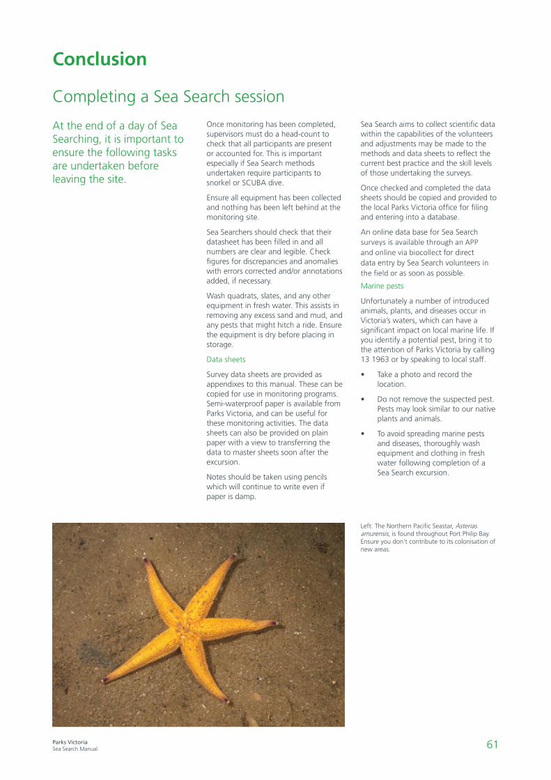
61Parks VictoriaSea Search Manual
Conclusion
Left: The Northern Pacific Seastar, Asterias amurensis, is found throughout Port Philip Bay. Ensure you don’t contribute to its colonisation of new areas.
Completing a Sea Search session
Once monitoring has been completed, supervisors must do a head-count to check that all participants are present or accounted for. This is important especially if Sea Search methods undertaken require participants to snorkel or SCUBA dive.
Ensure all equipment has been collected and nothing has been left behind at the monitoring site.
Sea Searchers should check that their datasheet has been filled in and all numbers are clear and legible. Check figures for discrepancies and anomalies with errors corrected and/or annotations added, if necessary.
Wash quadrats, slates, and any other equipment in fresh water. This assists in removing any excess sand and mud, and any pests that might hitch a ride. Ensure the equipment is dry before placing in storage.
Data sheets
Survey data sheets are provided as appendixes to this manual. These can be copied for use in monitoring programs. Semi-waterproof paper is available from Parks Victoria, and can be useful for these monitoring activities. The data sheets can also be provided on plain paper with a view to transferring the data to master sheets soon after the excursion.
Notes should be taken using pencils which will continue to write even if paper is damp.
Sea Search aims to collect scientific data within the capabilities of the volunteers and adjustments may be made to the methods and data sheets to reflect the current best practice and the skill levels of those undertaking the surveys.
Once checked and completed the data sheets should be copied and provided to the local Parks Victoria office for filing and entering into a database.
An online data base for Sea Search surveys is available through an APP and online via biocollect for direct data entry by Sea Search volunteers in the field or as soon as possible.
Marine pests
Unfortunately a number of introduced animals, plants, and diseases occur in Victoria’s waters, which can have a significant impact on local marine life. If you identify a potential pest, bring it to the attention of Parks Victoria by calling 13 1963 or by speaking to local staff.
• Take a photo and record thelocation.
• Do not remove the suspected pest.Pests may look similar to our nativeplants and animals.
• To avoid spreading marine pestsand diseases, thoroughly washequipment and clothing in freshwater following completion of aSea Search excursion.
At the end of a day of Sea Searching, it is important to ensure the following tasks are undertaken before leaving the site.

62Parks VictoriaSea Search Manual
What happens next?
Where does the data go?
Marine national parks and marine sanctuaries are protected primarily for conservation of marine values. Their management is guided by the establishment of clear Conservation Outcomes, providing goals for the protection of important natural values and the reduction in the levels of threats to these values.
Sea Search monitoring methods have been developed with these outcomes in mind, and aim to inform on progress in meeting these conservation goals for the parks. Data collected by volunteers through the Sea Search program is added to a state-wide database for Victoria’s marine national parks and marine sanctuaries.
Below: Parks Victoria recognises the significant efforts contributed by volunteers in collecting marine information.
Information in the Sea Search database is used to complement the less regular formal monitoring to assess park condition undertaken by scientists. The data is reviewed periodically by marine scientists and used to understand the state of the park and any changes observed, and to assess how the park is travelling in relation to achieving its conservation goals.
Sea Search data makes an important contribution to reports on the state of the parks and importantly to help inform future management directions. It is important to recognise your contribution of data collection noting that volunteer observations will incrementally build on existing knowledge help assess the effectiveness of management activity.
The data you collect is carefully reviewed, managed, and utilised to inform marine protected area programs.
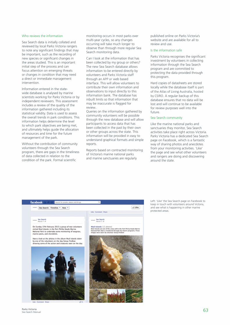
63Parks VictoriaSea Search Manual
Left: ‘Like’ the Sea Search page on Facebook to keep in touch with volunteers around Victoria, and see what is happening in other marine protected areas.
Who reviews the information
Sea Search data is initially collated and reviewed by local Parks Victoria rangers to note any significant findings that may be important, such as the recording of new species or significant changes in the areas studied. This is an important initial step of the process and can focus attention on emerging threats or changes in condition that may need a direct or immediate management intervention.
Information entered in the state-wide database is analysed by marine scientists working for Parks Victoria or by independent reviewers. This assessment includes a review of the quality of the information gathered including its statistical validity. Data is used to assess the overall trends in park conditions. This information helps determine the level to which park objectives are being met, and ultimately helps guide the allocation of resources and time for the future management of the park.
Without the contribution of community volunteers through the Sea Search program, there are gaps in the timeliness of data collected in relation to the condition of the park. Formal scientific
monitoring occurs in most parks over multi-year cycles, so any changes occurring will take much longer to observe than through more regular Sea Search monitoring data.
Can I look at the information that has been collected by my group or others? The new Sea Search database allows information to be entered directly by volunteers and Parks Victoria staff through an APP or web based interface. This will allow volunteers to contribute their own information and observations to input directly to this information bank. The database has inbuilt limits so that information that may be inaccurate is flagged for review. Queries on the information gathered by community volunteers will be possible through the new database and will allow participants to access data that has been collected in the past by their own or other groups across the state. This information will be provided in easy to understand graphical formats and simple reports.
Reports based on contracted monitoring of Victoria’s marine national parks and marine sanctuaries are regularly
published online on Parks Victoria’s website and are available for all to review and use.
Is the information safe
Parks Victoria recognises the significant investment by volunteers in collecting information through the Sea Search program and are committed to protecting the data provided through this program.
Hard copies of datasheets are stored locally while the database itself is part of the Atlas of Living Australia, hosted by CSIRO. A regular backup of this database ensures that no data will be lost and will continue to be available for review purposes well into the future.
Sea Search community
Like the marine national parks and sanctuaries they monitor, Sea Search activities take place right across Victoria. Parks Victoria has a dedicated Sea Search page on Facebook, which is a fantastic way of sharing photos and anecdotes from your monitoring activities. ‘Like’ the page and see what other volunteers and rangers are doing and discovering around the state.

64Parks VictoriaSea Search Manual
Contacts and resources
Program contact
Parks Victoria
Visit the Sea Search website at www.parkweb.vic.gov.au/get-involved/volunteer/sea-search
To contact any Parks Victoria office call 13 1963. Further information on Victoria’s park system can be obtained from: www.parkweb.vic.gov.au
Other useful contacts
Department of Environment, Land and Planning (DELWP) Ph: 136 186 www.coastsandmarine.vic.gov.au
EPA Victoria – Pollution report line Ph: 1300 EPA VIC (1300 372 842) www.epa.vic.gov.au
Fisheries Victoria Offence Reporting Hotline Ph: 13FISH (133 474)
ReefWatch Victoria Ph: 03 9341 6500 www.vnpa.org.au/reefwatch
Coastcare Victoria www.coastsandmarine.vic.gov.au/coastal-programs/coastcare
Online resources
Algae Base (ID resource) www.algaebase.org
Atlas of Living Australia www.ala.org.au
BirdLife Australia (survey info and publications) www.birdlife.org.au/
Bowerbird (natural history observations and data) www.bowerbird.org.au/
Census of Marine Life (network to compile marine diversity, distribution, and abundance data) www.coml.org.au
eFlora (Algae ID Resource) www.flora.sa.gov.au/algae_revealed/index.shtml
Explore Underwater Victoria (Victorian marine life images and video) www.exploreunderwatervictoria.org.au
Friends of the Bluff - Barwon Heads (guide books, apps) www.barwonbluff.com.au
Marine Care Ricketts Point (programs and ID guides) www.marinecare.org.au
Marine Discovery Centre Rocky Shores (online intertidal surveys) www.rockyshores.auz.info
Marine Education Society of Australasia (resources for schools) www.mesa.edu.au
Museum Victoria (ID resource for Victorian life) www.museumvictoria.com.au
Port Phillip Bay Taxonomic Toolkit (ID resource) www.portphillipmarinelife.net.au/
Redmap (mapping unusal marine species) www.redmap.org.au/
Reef Life Survey (subtidal reef monitoring) www.reeflifesurvey.com/
Further reading
Australian Marine Life. The Plants and Animals of Temperate Waters, Second Edition. GJ Edgar, 2008.
Life on the Rocky Shores, VNPA, 2010.
Museum Victoria Field Guides to Marine Life series, Museum Victoria.
Coastal Invertebrates of Victoria – An Atlas of Selected Species (revised), Field Naturalists Club of Victoria, 2006.
Coastal Marine Ecology of Temperate Australia, Underwood & Chapman, 1999.Marine Ecology, Connel & Gillanders, 2007
Department of Economic Development, Jobs, Transport and Resources (DEDJTR) – Marine Pests [email protected] A Guide to Southern Temperate
Seagrasses, Michelle Waycott, Kathryn McMahon, Paul Lavery, 2014.
Register as a volunteer - www.parkconnect.vic.gov.au Sea Search database - www.biocollect.ala.org.au

65Parks VictoriaSea Search Manual

66Parks VictoriaSea Search Manual
Appendix 1: Photograph naming protocols
To assist Parks Victoria staff in accurately filing and referencing Sea Search photographs, it’s important to follow the file naming protocol outlined here.
Camera Settings
When taking photos set the camera to take smaller sized images where possible e.g. 300-400 kB. Alternatively compress images using a program such as Microsoft picture manager. There is limited space for storing images so keeping the file sizes small will prevent problems with storage.
Saving and naming images
1. Download and clearly name photoswith site, and date details. Forexample, if doing method 3.3.2(large site seagrass boundaries)an image from the deep edgein Corner Inlet on the 13th ofApril 2012, at site 1, would bePV_COR_2012_04_13_S1_d.An image from Barwon Bluff,on the rocky intertidal, on the13th of April 2012, would bePV_BAR_2012_04_13_rockyint.
Location codes
Site Code
Cape Howe Marine National Park HOW
Point Hicks Marine National Park HIC
Ninety Mile Beach Marine National Park NIN
Corner Inlet Marine National Park COR
Wilsons Promontory Marine National Park WIL
Bunurong Marine National Park BUN
Churchill Island Marine National Park COR
French Island Marine National Park FRE
Yaringa Marine National Park YAR
Port Phillip Heads Marine National Park (Swan Bay) PPH_SW
Port Phillip Heads Marine National Park (Mud Islands) PPH_MI
Port Phillip Heads Marine National Park (Point Nepean) PPH_PN
Port Phillip Heads Marine National Park (Point Lonsdale) PPH_PL
Point Addis Marine National Park ADD
Twelve Apostles Marine National Park TWE
Discovery Bay Marine National Park DIS
Beware Reef Marine Sanctuary BEW
Mushroom Reef Marine Sanctuary MUS
Ricketts Point Marine Sanctuary RIC
Jawbone Marine Sanctuary JAW
Point Cooke Marine Sanctuary COO
Barwon Bluff Marine Sanctuary BAR
Point Danger Marine Sanctuary DAN
Eagle Rock Marine Sanctuary EAG
Marengo Reefs Marine Sanctuary MAR
The Arches Marine Sanctuary ARC
Merri Marine Sanctuary MER
2. Location codes for labels are foundbelow.
3. Each summary method includes anexample of how to label a photorelevant to the method being used.
Sending images to rangers
Images should be saved as a .jpeg file type and uploaded to the database or onto a USB and forwarded to rangers.
Storing images on parks network
Rangers should upload images to the database or store the images by date order in the relevant method folder for your region on the S: drive.
Appendices
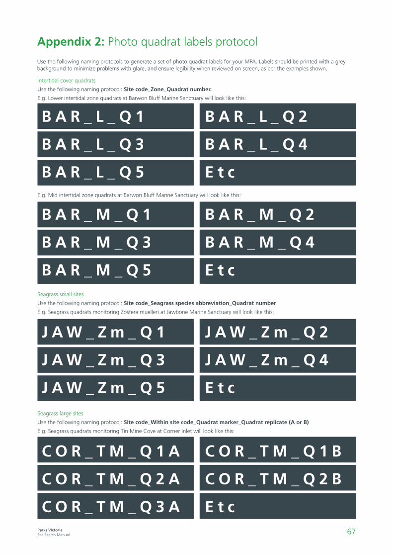
67Parks VictoriaSea Search Manual
B A R _ L _ Q 1
B A R _ L _ Q 3
B A R _ L _ Q 5
B A R _ L _ Q 2
B A R _ L _ Q 4
E t c
Appendix 2: Photo quadrat labels protocol
Use the following naming protocols to generate a set of photo quadrat labels for your MPA. Labels should be printed with a grey background to minimize problems with glare, and ensure legibility when reviewed on screen, as per the examples shown.
Intertidal cover quadrats
Use the following naming protocol: Site code_Zone_Quadrat number.
E.g. Lower intertidal zone quadrats at Barwon Bluff Marine Sanctuary will look like this:
Seagrass small sites
Use the following naming protocol: Site code_Seagrass species abbreviation_Quadrat number
E.g. Seagrass quadrats monitoring Zostera muelleri at Jawbone Marine Sanctuary will look like this:
Seagrass large sites
Use the following naming protocol: Site code_Within site code_Quadrat marker_Quadrat replicate (A or B)
E.g. Seagrass quadrats monitoring Tin Mine Cove at Corner Inlet will look like this:
E.g. Mid intertidal zone quadrats at Barwon Bluff Marine Sanctuary will look like this:
B A R _ M _ Q 1
B A R _ M _ Q 3
B A R _ M _ Q 5
B A R _ M _ Q 2
B A R _ M _ Q 4
E t c
J A W _ Z m _ Q 1
J A W _ Z m _ Q 3
J A W _ Z m _ Q 5
J A W _ Z m _ Q 2
J A W _ Z m _ Q 4
E t c
C O R _ T M _ Q 1 A
C O R _ T M _ Q 2 A
C O R _ T M _ Q 3 A
C O R _ T M _ Q 1 B
C O R _ T M _ Q 2 B
E t c
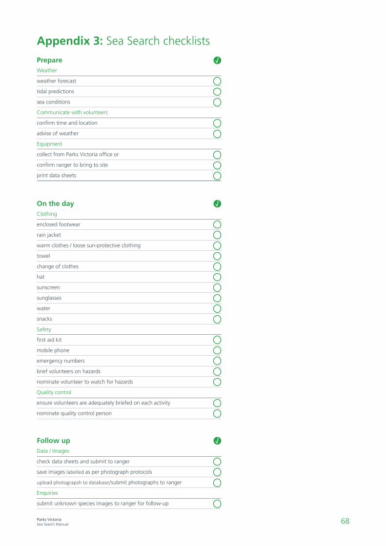
68Parks VictoriaSea Search Manual
Appendix 3: Sea Search checklists
PrepareWeather
weather forecast
tidal predictions
sea conditions
Communicate with volunteers
confirm time and location
advise of weather
Equipment
collect from Parks Victoria office or
confirm ranger to bring to site
print data sheets
√
√
√Follow upData / Images
check data sheets and submit to ranger
save images labelled as per photograph protocols
upload photograpsh to database/submit photographs to ranger
Enquiries
submit unknown species images to ranger for follow-up
Clothing
enclosed footwear
rain jacket
warm clothes / loose sun-protective clothing
towel
change of clothes
hat
sunscreen
sunglasses
water
snacks
Safety
first aid kit
mobile phone
emergency numbers
brief volunteers on hazards
nominate volunteer to watch for hazards
Quality control
ensure volunteers are adequately briefed on each activity
nominate quality control person
On the day

69Parks VictoriaSea Search Manual
Field information sheet
Location:
Site(s):
Participants:
Sea Search methods:
Conditions
Wind Speed (km/hr):
Air temperature(˚C):
Rain (circle): YES / NO
Time low tide:
Water clarity (circle): Excellent / Fair / Poor
Other notes:
Date:
Start time: End time:
Wind direction:
Cloud cover (circle): None Low Med High
Height low tide (m):
Water temp (˚C):
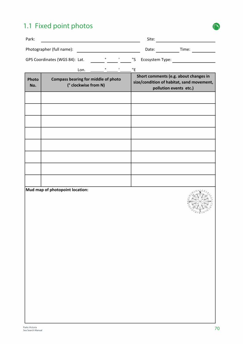
70Parks VictoriaSea Search Manual
1.1 Fixed point photos
Park: Site:
Photographer (full name): Date: Time:
Lat. ° ' "S
Lon. ° ' "E
Photo
No.
GPS Coordinates (WGS 84): Ecosystem Type:
Short comments (e.g. about changes in
size/condition of habitat, sand movement,
pollution events etc.)
Compass bearing for middle of photo
(° clockwise from N)
Mud map of photopoint location:

71
1.2 Species Image Library
Parks VictoriaSea Search ManualParks Victoria
Sea Search Manual
Parks VictoriaSea Search Manual
Parks VictoriaSea Search Manual
Park: Site (if relevant):
Photographer (full name): Date:
Scientific nameEcosystemPhoto
No.
Native, over-
abundant
(O/A) or pest?
Brief comments (if any)
Species of
conservation
concern?
Species out of
normal range?Common name

Marine National Park/Marine Sanctuary:_________________________________Site:__________________________________ Date:_________________
Cloud cover/Wind strength/Rainfall: ___________________/___________________________/_______________________ Method: Snorkel / Walk
Recorder (full names) ___________________________________________________________________________________Start time________End time____
Total duration of activity observed ____________________ minutes
Activity Number Activity Number Activity Number Observation Number/Description Stationary Swimming Dog walking ON lead Disturbance of wildlife
Walking Wading Dogs OFF lead Litter
Overturning rocks Dive/Snorkel Motor boats Pollution
Collecting Kayak/surf ski Sail boats
Fossicking/Exploring Line Fishing
Surfing Spear Fishing
Records of disturbance, litter, range expanding species, or other impacts (any marine pests use SPECIES IMAGE LIBRARY).
Biological notes: E.g. snail eggs, unusual abundance of species Mudmap/notes:
72
1.3 Sea Search Patrol
Parks VictoriaSea Search Manual

Park: Site (if relevant):
Observers (full names): Sea Search method:
Date: Start Time: End Time:
Point intercept counts Invertebrate No.
(Photoquadrats & Rapid method 2.1) (Detailed method 2.2)
Qu
ad
rat
No
.
(�) Ho
rmo
sira
ba
nksi
iG
ale
ola
ria
ca
esp
ito
saU
lva
sp
p.
Lim
no
pe
rna
pu
lex
En
cru
stin
g c
ora
llin
eC
ora
llin
e t
urf
Oth
er
Ce
lla
na
tra
mo
seri
caB
em
bic
ium
na
nu
m (
Op
en
co
ast
)B
. m
ela
na
sto
mu
m (
Ba
ys)
Ne
rita
atr
am
en
tosa
Sip
ho
na
ria
ze
lan
dic
aA
ust
roco
chle
a c
on
stri
cta
(O
pe
n c
oa
st)
A.
po
rca
ta (
Ba
ys)
Oth
er
1
2
3
4
5
6
7
8
9
10
11
12
13
14
15
16
Comments (e.g. trampling, marine pests, other…)
2.1 & 2.2 Intertidal Reef Surveys - Rapid & Detailed (Low Intertidal Zone)
Parks Victoria
Sea Search Manual74

Park: Site (if relevant):
Sea Search method: Observers (full names):
Date: Start Time: End Time:
Point intercept counts Invertebrate No.
(Photoquadrats & Rapid method 2.1) (Detailed method 2.2)
Qu
ad
rat
No
.
(�) Ho
rmo
sira
ba
nksi
iG
ale
ola
ria
ca
esp
ito
saU
lva
sp
p.
Lim
no
pe
rna
pu
lex
En
cru
stin
g c
ora
llin
eC
ora
llin
e t
urf
Oth
er
Ce
lla
na
tra
mo
seri
caB
em
bic
ium
na
nu
m (
Op
en
co
ast
)B
. m
ela
na
sto
mu
m (
Ba
ys)
Ne
rita
atr
am
en
tosa
Sip
ho
na
ria
ze
lan
dic
aA
ust
roco
chle
a c
on
stri
cta
(O
pe
n c
oa
st)
A.
po
rca
ta (
Ba
ys)
Oth
er
1
2
3
4
5
6
7
8
9
10
11
12
13
14
15
16
Comments (e.g. trampling, marine pests, other…)
75
2.1 & 2.2 Intertidal Reef Surveys - Rapid & Detailed (Mid Intertidal Zone)
Parks Victoria
Sea Search Manual

76Parks VictoriaSea Search Manual
Location:
Site(s):
Participants:
Other notes:
Date:
Start time: End time:
2.3 Catch per unit effort
mm mm
Target species: Control species
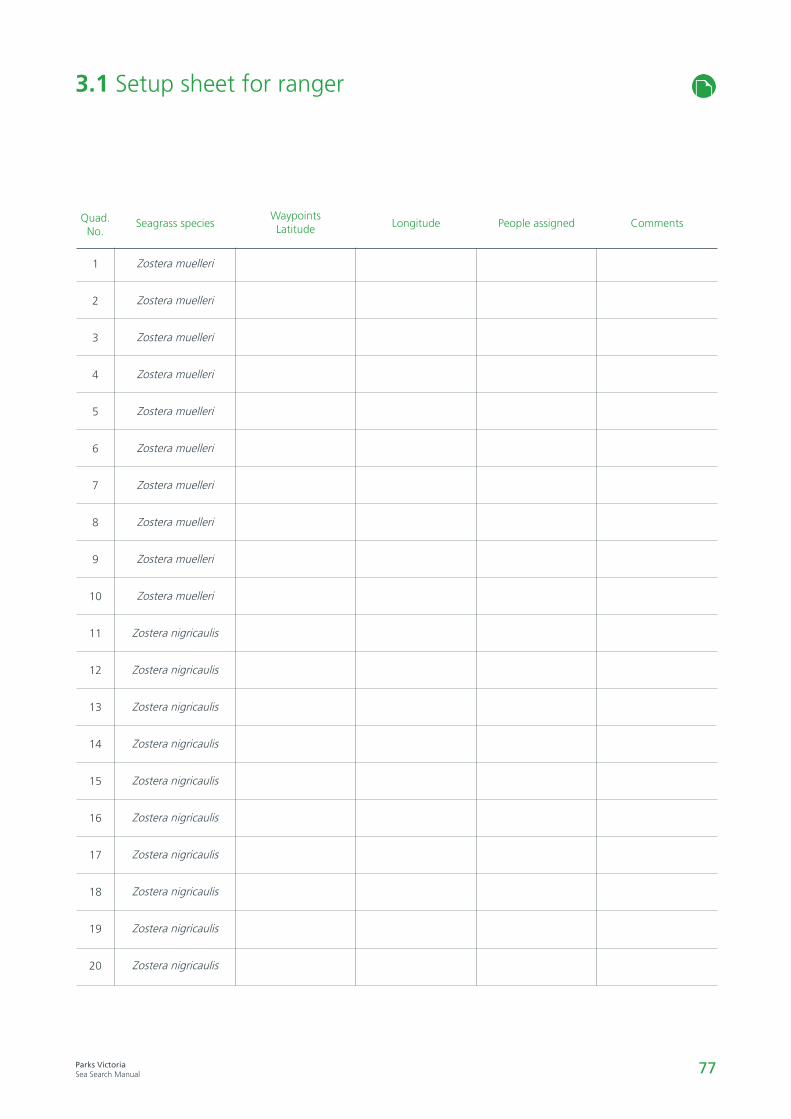
77Parks VictoriaSea Search Manual
3.1 Setup sheet for ranger
Quad.No.
1
2
3
4
5
6
7
8
9
10
11
12
13
14
15
16
17
18
19
20
Seagrass species
Zostera muelleri
Zostera muelleri
Zostera muelleri
Zostera muelleri
Zostera muelleri
Zostera muelleri
Zostera muelleri
Zostera muelleri
Zostera muelleri
Zostera muelleri
Zostera nigricaulis
Zostera nigricaulis
Zostera nigricaulis
Zostera nigricaulis
Zostera nigricaulis
Zostera nigricaulis
Zostera nigricaulis
Zostera nigricaulis
Zostera nigricaulis
Zostera nigricaulis
WaypointsLatitude Longitude People assigned Comments

78Parks VictoriaSea Search Manual
Seagrass field information sheet (small site)
Location:
Site(s):
Participants:
Sea Search methods:
Conditions
Wind Speed (km/hr):
Air temperature(˚C):
Rain (circle): YES / NO
Time low tide:
Swell (m):
Sediment (circle): Mud / Fine Sand / Sand / Coarse Sand / Gravel
GPS coordinates for each quadrat
Date:
Start time: End time:
Wind direction:
Water temp (˚C):
Cloud cover (circle): None Low Med High
Tide level (m): High = Low =
Water depth (m):
Visibility (m):
Other notes: e.g. general appearance of seagrass, distance from channels/gutters, current strength at time, presence/absence of sponges or other sessile marine life, notable sightings, photos taken etc.
Latitude LongitudeQuad.No.
1
2
3
4
5
6
7
8
9
10
Quad. No.
11
12
13
14
15
16
17
18
19
20
Latitude Longitude

79Parks VictoriaSea Search Manual
Seagrass field information sheet (large site)
Location:
Site(s):
Participants:
Sea Search methods:
Conditions
Wind Speed (km/hr):
Air temperature(˚C):
Rain (circle): YES / NO
Time low tide:
Swell (m):
Sediment (circle): Mud / Fine Sand / Sand / Coarse Sand / Gravel
GPS coordinate (take reading from middle of 6 quadrat pairs)
Date:
Start time: End time:
Wind direction:
Water temp (˚C):
Cloud cover (circle): None Low Med High
Tide level (m): High = Low =
Water depth (m):
Visibility (m):
Other notes: e.g. general appearance of seagrass, distance from channels/gutters, current strength at time, presence/absence of sponges or other sessile marine life, notable sightings, photos taken etc.

Park: Site (if relevant):
Observers (full names): Sea Search method:
Seagrass Zone (circle): intertidal / subtidal Main seagrass species:
Date: Start Time: End Time:
Rapid methods - 3.1.1 & 3.2.1 Detailed methods - 3.1.2 & 3.2.2
Qu
ad
rat
No
.
(�) Sedim
ent T
ype (
see k
ey)
Zoste
ra m
uelle
ri (
ZM
) %
cover
Zoste
ra n
igricaulis
(Z
N)
% c
over
Posid
onia
austr
alis
(P
A)
% c
over
Bare
sedim
ent %
cover*
Macro
alg
ae %
cover
(not epip
hyte
s)
Oth
er:
Epip
hyte
s %
cover
(see m
eth
ods)
Canopy h
eig
ht (c
m)
No. of S
hoots
(P
A o
nly
- ½
quadra
t)Sn
ails
Biv
alv
es
Sea
sta
rs
Urc
hin
s
Spo
ng
es
Oth
er:
1
2
3
4
5
6
7
8
9
10
11
12
13
14
15
16
17
18
19
20
Sediment Key: M=Mud FS=Fine Sand S=Sand CS=Coarse Sand G=Gravel.
* Distance between seagrass shoots must be more than a hand span to be categorised as “Bare sediments”
Comments/observations:
Total % Cover (must = 100%) Animal No.'s
3.1.1, 3.1.2, 3.2.1 & 3.2.2 Seagrass Condition Rapid & Detailed / Small & Large Sites (Seagrass Zone 1)
Parks VictoriaSea Search Manual
80
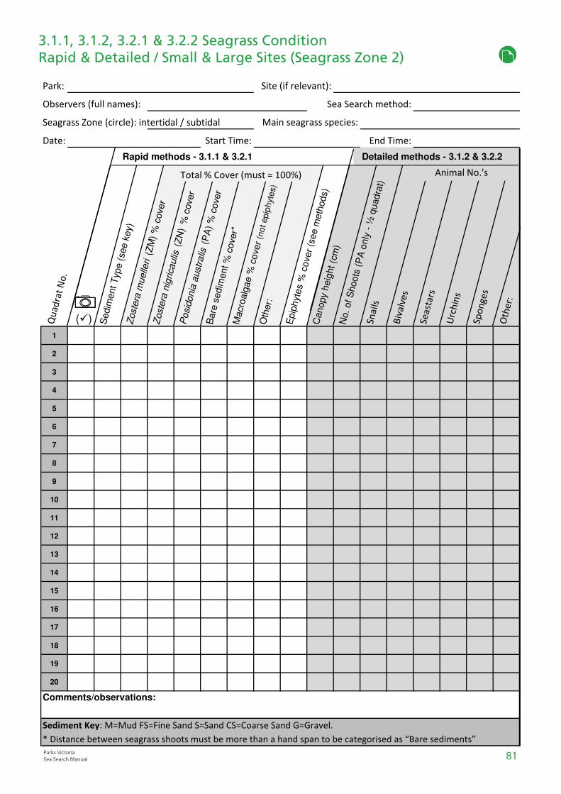
Park: Site (if relevant):
Observers (full names): Sea Search method:
Seagrass Zone (circle): intertidal / subtidal Main seagrass species:
Date: Start Time: End Time:
Rapid methods - 3.1.1 & 3.2.1 Detailed methods - 3.1.2 & 3.2.2
Qu
ad
rat
No
.
(�) Sedim
ent T
ype (
see k
ey)
Zoste
ra m
uelle
ri (
ZM
) %
cover
Zoste
ra n
igricaulis
(Z
N)
% c
over
Posid
onia
austr
alis
(P
A)
% c
over
Bare
sedim
ent %
cover*
Macro
alg
ae %
cover
(not epip
hyte
s)
Oth
er:
Epip
hyte
s %
cover
(see m
eth
ods)
Canopy h
eig
ht (c
m)
No. of S
hoots
(P
A o
nly
- ½
quadra
t)Sn
ails
Biv
alv
es
Sea
sta
rs
Urc
hin
s
Spo
ng
es
Oth
er:
1
2
3
4
5
6
7
8
9
10
11
12
13
14
15
16
17
18
19
20
Sediment Key: M=Mud FS=Fine Sand S=Sand CS=Coarse Sand G=Gravel.
* Distance between seagrass shoots must be more than a hand span to be categorised as “Bare sediments”
Comments/observations:
Total % Cover (must = 100%) Animal No.'s
3.1.1, 3.1.2, 3.2.1 & 3.2.2 Seagrass Condition Rapid & Detailed / Small & Large Sites (Seagrass Zone 2)
Parks VictoriaSea Search Manual 81
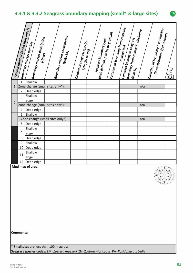
Tran
sect
nu
mb
er (
smal
l sit
es o
nly
*)
Bo
un
dar
y m
arke
r n
um
ber
Bo
un
dar
y m
arke
r d
escr
ipti
on
(c
ircl
e)
Bo
un
dar
y m
arke
r co
ord
inat
es
(WG
S 84
)
Do
min
ant
seag
rass
sp
ecie
s (Z
M, Z
N o
r P
A)
Seag
rass
bo
un
dar
y ty
pe
(wel
l def
ined
, pat
chy
or
grad
ual
)D
ista
nce
of
bo
un
dar
y fr
om
rel
evan
t m
arke
r (m
)C
om
pas
s b
eari
ng
of
seag
rass
bo
un
dar
y fr
om
mar
ker(
° cl
ock
wis
e
fro
m N
)
Dir
ecti
on
of
bo
un
dar
y fr
om
mar
ker
(in
war
d/o
utw
ard
/at
mar
ker)
(
✓
)
1 Shallow
2 Deep edge
3Shallow
edge
4 Deep edge
5 Shallow
6 Deep edge
7Shallow
edge
8 Deep edge
9 Shallow
10 Deep edge
11Shallow
edge
12 Deep edge
* Small sites are less than 100 m across
Seagrass species codes: ZM=Zostera muelleri ZN=Zostera nigricaulis PA=Posidonia australis .
Comments:
Zone change (small sites only*):
Zone change (small sites only*):
Zone change (small sites only*):
n/a
n/a
n/a
1
2
3
Mud map of area:
3.3.1 & 3.3.2 Seagrass boundary mapping (small* & large sites)
82Parks VictoriaSea Search Manual
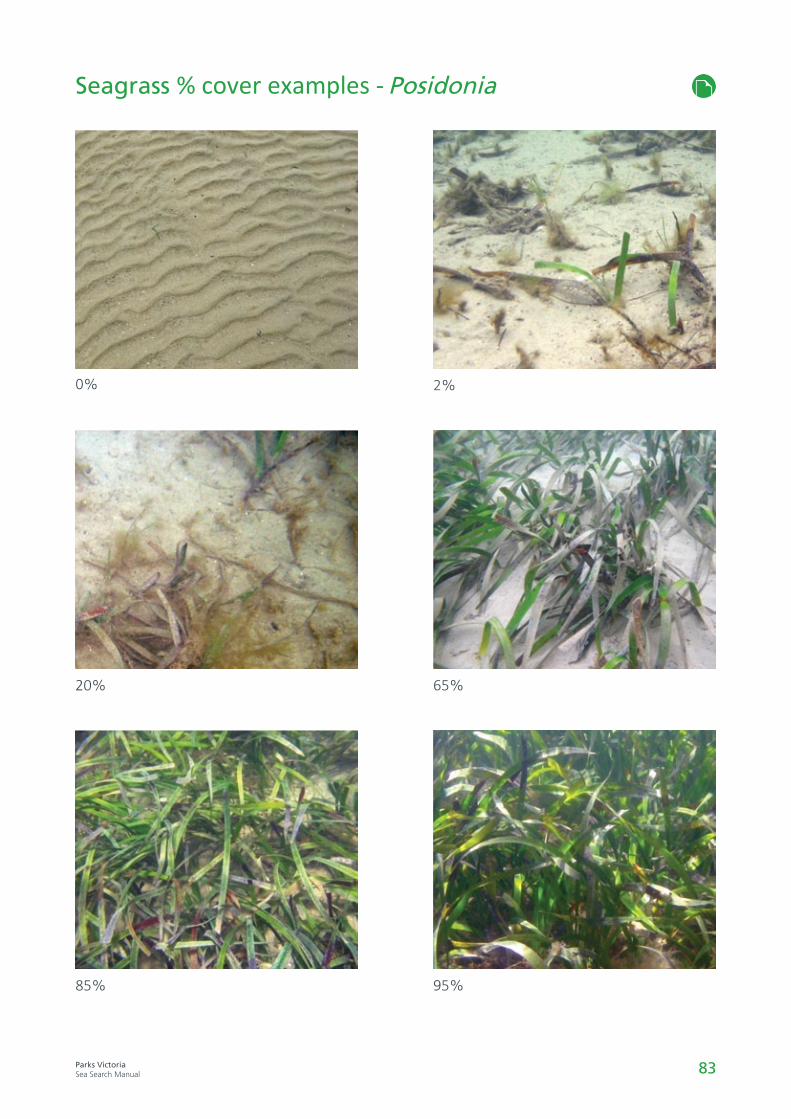
83Parks VictoriaSea Search Manual
Seagrass % cover examples - Posidonia
0%
20%
85%
2%
65%
95%
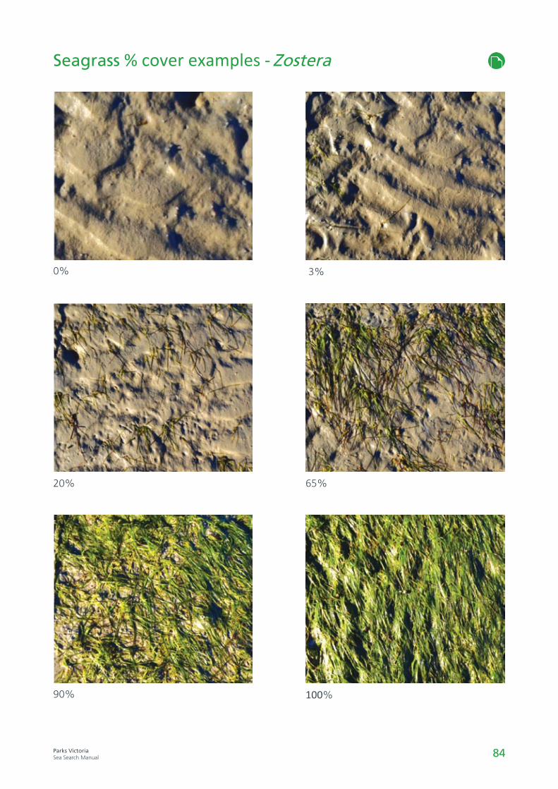
84Parks VictoriaSea Search Manual
Seagrass % cover examples - Zostera
0%
20%
90%
3%
65%
100%
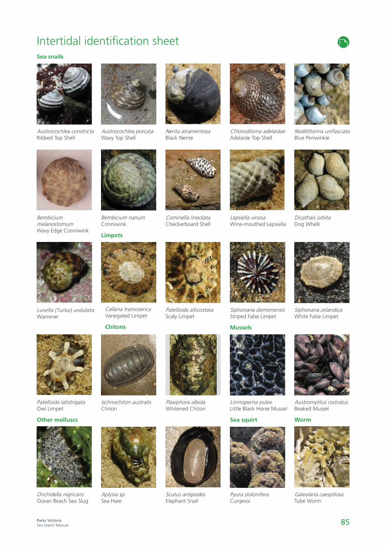
85Parks VictoriaSea Search Manual
Intertidal identification sheet
Nerita atramentosaBlack Nerite
Cominella lineolataCheckerboard Shell
Patelloida alticostataScaly Limpet
Plaxiphora albidaWhitened Chiton
Scutus antipodesElephant Snail
Austrocochlea constrictaRibbed Top Shell
Bembicium nanum Conniwink
Cellana tramosericaVariegated Limpet
Lunella (Turbo) undulata Warrener
Onchidella nigricansOcean Beach Sea Slug
Sea snails
Limpets
Other molluscs
Austrocochlea porcataWavy Top Shell
Bembicium melanostomumWavy Edge Conniwink
Patelloida latistrigataOwl Limpet
Ischnochiton australisChiton
Aplysia sp.Sea Hare
Chitons
Chlorodiloma adelaidaeAdelaide Top Shell
Lepsiella vinosaWine-mouthed Lepsiella
Siphonaria diemenensisStriped False Limpet
Limnoperna pulex Little Black Horse Mussel
Mussels
Pyura stoloniferaCunjevoi
Sea squirt
Nodilittorina unifasciataBlue Periwinkle
Dicathais orbitaDog Whelk
Siphonaria zelandicaWhite False Limpet
Austromytilus rostratusBeaked Mussel
Galeolaria caespitosaTube Worm
Worm
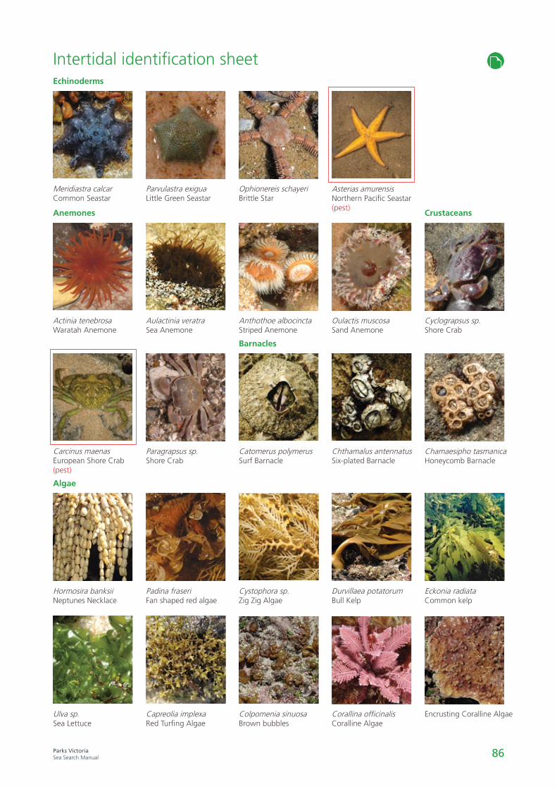
86Parks VictoriaSea Search Manual
Parvulastra exiguaLittle Green Seastar
Aulactinia veratraSea Anemone
Paragrapsus sp.Shore Crab
Padina fraseriFan shaped red algae
Capreolia implexaRed Turfing Algae
Cyclograpsus sp.Shore Crab
Chamaesipho tasmanicaHoneycomb Barnacle
Eckonia radiataCommon kelp
Encrusting Coralline Algae
Crustaceans
Ophionereis schayeriBrittle Star
Anthothoe albocinctaStriped Anemone
Catomerus polymerusSurf Barnacle
Cystophora sp.Zig Zig Algae
Colpomenia sinuosaBrown bubbles
Barnacles
Intertidal identification sheet
Oulactis muscosaSand Anemone
Chthamalus antennatusSix-plated Barnacle
Durvillaea potatorumBull Kelp
Corallina officinalisCoralline Algae
Asterias amurensisNorthern Pacific Seastar(pest)
Meridiastra calcarCommon Seastar
Actinia tenebrosaWaratah Anemone
Hormosira banksiiNeptunes Necklace
Ulva sp.Sea Lettuce
Echinoderms
Anemones
Algae
Carcinus maenasEuropean Shore Crab(pest)

87Parks VictoriaSea Search Manual
Halophila australisPaddle Weed
PosidoniaSeed Pod
Red algae
Zostera nigricaulisDark-stem Eelgrass
Zostera spp.Flower Spike
Seagrass species
Posidonia australisBroad-leaf Seagrass
Zostera muelleriNarrow-leaf Eelgrass(intertidal)
Brown algae
Epiphytes
Amphibolis antarticaSea Nymph
Seagrass indentification sheet
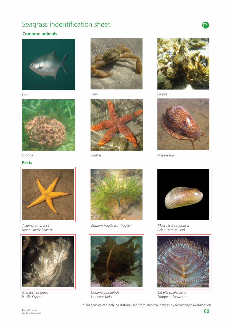
88Parks VictoriaSea Search Manual
Seagrass indentification sheet
Fish
Sponge
Asterias amurensisNorth Pacific Seastar
Crassostrea gigasPacific Oyster
Common animals
Pests
Seastar
Codium fragile ssp. fragile*
Undaria pinnatifidaJapanese Kelp
Crab Bivalve
Marine snail
Musculista senhousiaAsian Date Mussel
Sabella spallanzaniiEuropean Fanworm
*This species can only be distinguised from identical natives by microscopic examination

89Parks VictoriaSea Search Manual
Algae
A photosynthetic, plant-like single- or multi-cellular organism.
Angiosperm
A group of plants where the seed is formed within an ovary.
Biodiversity
The number, relative abundance and genetic diversity of organisms on earth.
Bivalve
An animal in the mollusc group that has two valves joined at the margin by an elastic ligament and hinge teeth.
Carnivore
An animal that feeds exclusively on other animals as a food source.
Chlorophyll
The green pigment of plant cells, which is the receptor of light energy in photosynthesis.
Colonisation
The ability for an organism to settle and reproduce in a habitat.
Datum
A known, fixed point.
Desiccate
To dry out, lose moisture.
Ecology
The interaction between plants, animal and micro-organism communities.
Epiphyte
A small plant that grows attached to another plant.
Erosion
The loss of soil by the action of wind or water, or both.
Estuarine
The area or habitat where fresh water from a river meets the salt water of the ocean.
Filter-Feeder
Animals that obtain food by filtering suspended organisms and particles from a volume of water by passing the water over a set of specialised structures.
GPS
Global Positioning System used to navigate and mark locations.
Grazer
An animal that feeds on vegetable tissue from herbaceous plants.
Herbivore
An animal that feeds exclusively on plant material as a food source.
Intertidal
The area of coast which is covered by water at high tide, and uncovered at low tide.
Invertebrate
An animal without a backbone.
Photosynthesis
The process by which light energy is used to create chemical bonds with carbon dioxide and water.
Predator
An organism that catches and kills another organism for food.
Quadrat
A defined area for scientific sampling, and the frame that is used to define this area.
Qualitative
Relating to, measuring, or measured by the quality of something rather than its quantity.
Quantitative
Relating to, measuring, or measured by the quantity of something rather than its quality.
Salinity
A measure of dissolved salt concentration in water.
SCUBA
Self-Contained Underwater Breathing Apparatus.
Sessile
Attached; not free to move about.
Substratum
A base which a sessile animal or plant is fixed.
Subtidal
The area of coast which is covered by water at low tide.
Toxin
A poisonous compound.
Turbidity
The measure of water clarity.
Vagrant
Individual animals of a species that appear well outside their normal range.
Glossary

General Quality Control Guidelines • Read up and familiarise yourself with the methods before the day of a survey. If unsure how
to implement any of the methods refer to the relevant video clip, or speak to your ranger.
• Take step-by-step instructions with you when you go out into the field, and follow themclosely. These are available on the Sea Search website, and from your ranger on the day ofan activity.
• All groups doing quadrat sampling should be briefed before starting that one way ofensuring accuracy is for more than one person to count the species and intercept points ineach quadrat (from the same position) to make sure they both get the same count.
• At least one person in the volunteer group should be identified as the QC person (thisperson is likely experienced at the method and familiar with the species).
• Make sure the GPS unit you are using is set to the correct format each time you go out, soyou are coming back to the same (randomly assigned) quadrat sites each time. Note thatParks Victoria uses the WGS84 format displayed in Degrees, Minutes and Seconds.
• Ensure all relevant data has been collected (i.e. datasheets should have no gaps). Check youhave recorded a complete set of data before moving to the next quadrat, or the nextmethod.
• Have your partner check your data.
• Enter data into the APP/database as soon as possible after the survey has beencompleted.
• Keep up to date on species ID and take ID guides out into the field as necessary. To improveID skills attend training courses where available and share your knowledge with others. Ifunsure about a species write a detailed description and take photos so your ranger can seekthe advice of experts in marine taxonomy.
• If you are unsure about anything ask your ranger.
Quality Control Specific to Rocky Shores • Point intercept counts should not total more than 49 (it may be less as bare rock and sand
are not counted). Only the top layer of algae is counted not any understorey.
• If measuring snails and limpets for the detailed intertidal reef methods make sure that thespecies are correctly identified (e.g. juvenile Dicathais orbita may be confused with Lepsiellavinosa).
• Spot check between groups (at least once for each group during the event) to make sureeveryone is sampling and recording correctly (e.g. point intercept counts are accurate,species are correctly identified, photos are clear and in focus and named accurately).
Quality Control Specific to Seagrass • Spot check between groups (at least once for each group during the event) to make sure
everyone is sampling and recording correctly (e.g. cover composition totals 100%, speciesare correctly identified, photos are clear and in focus and named accurately).
90Parks VictoriaSea Search Manual

91Parks VictoriaSea Search Manual
Notes
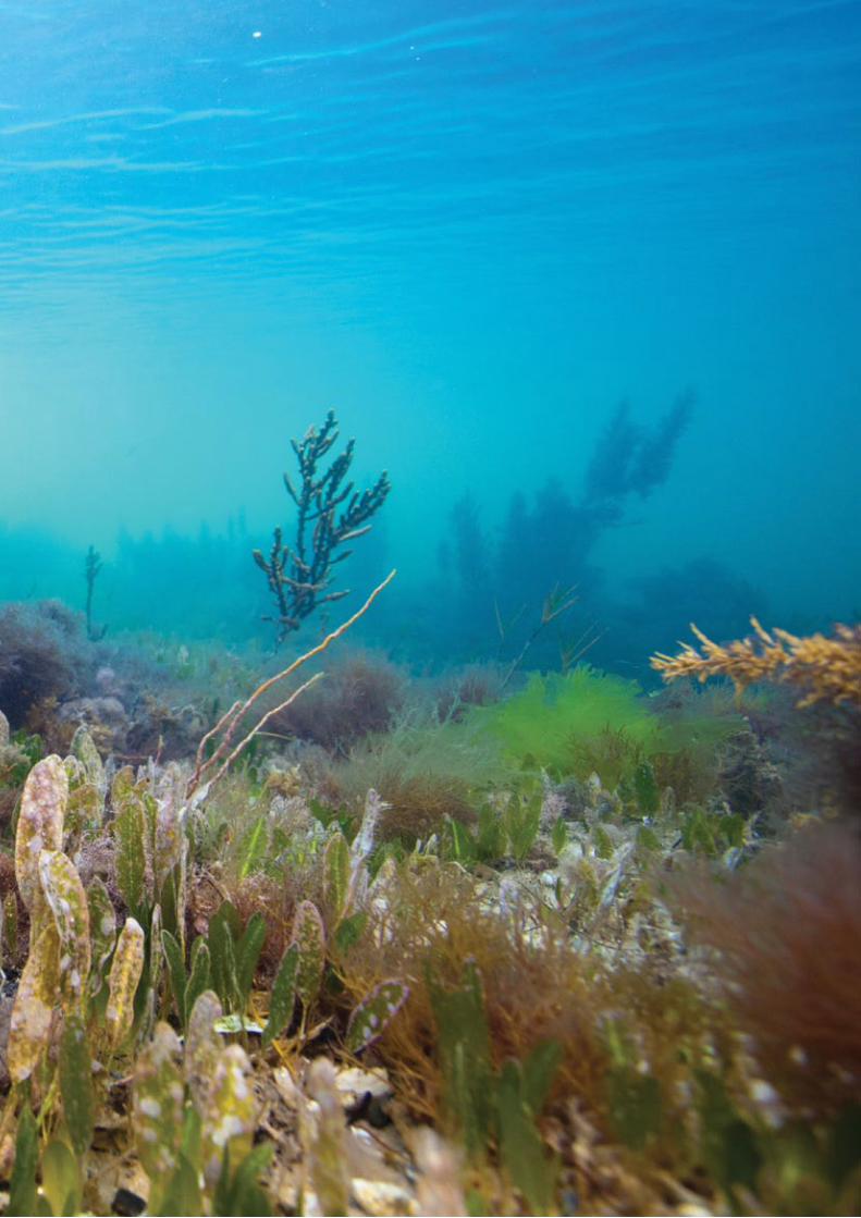
95Parks VictoriaSea Search Manual
96Parks VictoriaSea Search Manual


