Introduction The name Southern Alps belies the longstanding and frequent comparison of the mountain ranges of the South Island of New Zealand with the European Alps. Comparison of the 2 mountain ranges derives largely from similar geomorphology: They have similar relief, both have numerous glaciers, and the landscapes of both show the strong imprint of expanded glaciers dur- ing the Quaternary. This article seeks to understand the basis of similarities and differences by examining geolo- gy, tectonic development, the impacts of Quaternary cli- mate change, and the current rates of landscape devel- opment. The European Alps (Alps) are a mountain range almost 1000 km long, running from west to east between Genoa and Vienna (Figure 1a). Southeast of Genoa, they continue into the Apennines, east of the Vienna Basin into the Carpates, and southeast of Ljubl- jana into the Dinarids. The Alps emerged at the end of the Cretaceous and during the Tertiary. As a result of the collision of the African and European Plates, the Earth’s crust thickened from an average of 30 km up to 60 km. The uplift and appearance of the Alps as a high mountain system are relatively recent phenomena, driv- en by isostatic compensation and an upward movement of the lighter continental crust (2.7 g/cm 3 ), which had been suppressed into the oceanic crust (3.0 g/cm 3 ). Due to strong tectonic compression, the western Alps are narrower (ca 150 km, along the Berne–Milan axis) and reach higher elevations (Mont Blanc, 4807 m; Fig- ure 5a) than the Eastern Alps (ca 250 km along the Munich–Venice axis; Grossglockner, 3797 m). From the margins to the center, the topography of the Alps is more or less symmetric, with the highest mountain ranges in the central part. The steep relief and the ele- vation of the Alps high above the timber- and snowlines continue to favor intense and often catastrophic geo- morphic processes. Together with increasing popula- tion density, these are the reasons for the high risk of natural hazards. The South Island of New Zealand is dominated by the Southern Alps, which form an unbroken, 500-km- long mountain range from the inland Kaikoura Range to the mountains of Fiordland (Figure 1b). The central part of the range is 300 km long, 120 km wide, and has summits higher than 3000 m. Compared with the Alps, the Southern Alps of New Zealand are younger, have a sharper topographic expression, and are being shaped by forces of uplift and erosion of considerably greater magnitude. Like the Alps, the Southern Alps owe their origin to the collision of 2 tectonic plates. The main topographic expression of the Southern Alps was formed in Late Cenozoic times, as the Pacific Plate col- lided with the Indo-Australian Plate. Collision resulted in the leading edge of the Pacific Plate becoming upturned and rapidly uplifted. Rapid uplift along the plate boundary produced a mountain range with an asymmetrical cross-section with a steeper face on the western side, where peaks of 3000 m occur less than 40 km from the Tasman Sea. The topography on the eastern side of the Southern Alps is characterized by intermontane basins and broad alluvial plains that sepa- rate the highest peaks from the Pacific Ocean by more than 100 km. Geology and tectonics European Alps The Alps consist of parts of the European Plate, a for- mer Jurassic to Lower Cretaceous ocean floor, and the Adria Plate as part of the African Plate. A complicated The European Alps (Alps) and Southern Alps of New Zealand (Southern Alps) are both high mountain ranges formed by the collision of tectonic plates. The Alps result- ed from collision of the African and European Plates, which produced complex lithological and structural pat- terns associated with the development of a series of overthrusted nappes. In contrast, the plate margin defor- mation that created the Southern Alps produced a rela- tively simple structural and lithological pattern dominated by a single right lateral oblique slip fault zone known as the Alpine Fault. Strong contrasts are also apparent in the contemporary rates of landscape development. The Alps currently experience modest rates of uplift and denudation because deformation along the plate bound- ary has slowed. High rates of compressional strain along the Alpine Fault in New Zealand result in very high rates of uplift. These processes and the position of the moun- tain range across the prevailing atmospheric westerly cir- culation system result in exceptionally high rates of denudation. Although there are strong contrasts in the lithology and structure of the Alps and Southern Alps, both experienced the growth and decay of expanded val- ley and piedmont glaciers during the Quaternary. The impact of multiple Quaternary ice advances has left a strong imprint on the landscapes. Both mountain ranges have particularly well-developed, over-deepened troughs and widespread glacial sediments and landforms, which heavily influence modern geomorphic processes and land use. Today numerous glaciers in both regions show strong reactions to global warming since the end of the Little Ice Age. Keywords: Orogeny; tectonics; glaciations; chronostratig- raphy; landscape development; European Alps; Southern Alps; New Zealand. Peer reviewed: July 2001. Accepted: August 2001. Geology and Geomorphology of the European Alps and the Southern Alps of New Zealand A Comparison Sean J. Fitzsimons and Heinz Veit 340 Mountain Research and Development Vol 21 No 4 Nov 2001: 340–349
Transcript
Introduction
The name Southern Alps belies the longstanding andfrequent comparison of the mountain ranges of theSouth Island of New Zealand with the European Alps.Comparison of the 2 mountain ranges derives largelyfrom similar geomorphology: They have similar relief,both have numerous glaciers, and the landscapes ofboth show the strong imprint of expanded glaciers dur-ing the Quaternary. This article seeks to understand thebasis of similarities and differences by examining geolo-gy, tectonic development, the impacts of Quaternary cli-mate change, and the current rates of landscape devel-opment.
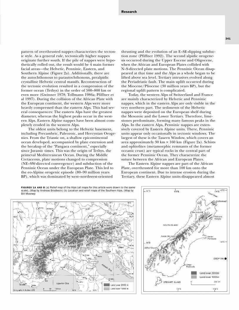
The European Alps (Alps) are a mountain rangealmost 1000 km long, running from west to eastbetween Genoa and Vienna (Figure 1a). Southeast of
Genoa, they continue into the Apennines, east of theVienna Basin into the Carpates, and southeast of Ljubl-jana into the Dinarids. The Alps emerged at the end ofthe Cretaceous and during the Tertiary. As a result ofthe collision of the African and European Plates, theEarth’s crust thickened from an average of 30 km up to60 km. The uplift and appearance of the Alps as a highmountain system are relatively recent phenomena, driv-en by isostatic compensation and an upward movementof the lighter continental crust (2.7 g/cm3), which hadbeen suppressed into the oceanic crust (3.0 g/cm3).Due to strong tectonic compression, the western Alpsare narrower (ca 150 km, along the Berne–Milan axis)and reach higher elevations (Mont Blanc, 4807 m; Fig-ure 5a) than the Eastern Alps (ca 250 km along theMunich–Venice axis; Grossglockner, 3797 m). From themargins to the center, the topography of the Alps ismore or less symmetric, with the highest mountainranges in the central part. The steep relief and the ele-vation of the Alps high above the timber- and snowlinescontinue to favor intense and often catastrophic geo-morphic processes. Together with increasing popula-tion density, these are the reasons for the high risk ofnatural hazards.
The South Island of New Zealand is dominated bythe Southern Alps, which form an unbroken, 500-km-long mountain range from the inland Kaikoura Rangeto the mountains of Fiordland (Figure 1b). The centralpart of the range is 300 km long, 120 km wide, and hassummits higher than 3000 m. Compared with the Alps,the Southern Alps of New Zealand are younger, have asharper topographic expression, and are being shapedby forces of uplift and erosion of considerably greatermagnitude. Like the Alps, the Southern Alps owe theirorigin to the collision of 2 tectonic plates. The maintopographic expression of the Southern Alps wasformed in Late Cenozoic times, as the Pacific Plate col-lided with the Indo-Australian Plate. Collision resultedin the leading edge of the Pacific Plate becomingupturned and rapidly uplifted. Rapid uplift along theplate boundary produced a mountain range with anasymmetrical cross-section with a steeper face on thewestern side, where peaks of 3000 m occur less than40 km from the Tasman Sea. The topography on theeastern side of the Southern Alps is characterized byintermontane basins and broad alluvial plains that sepa-rate the highest peaks from the Pacific Ocean by morethan 100 km.
Geology and tectonics
European AlpsThe Alps consist of parts of the European Plate, a for-mer Jurassic to Lower Cretaceous ocean floor, and theAdria Plate as part of the African Plate. A complicated
The European Alps (Alps) and Southern Alps of NewZealand (Southern Alps) are both high mountain rangesformed by the collision of tectonic plates. The Alps result-ed from collision of the African and European Plates,which produced complex lithological and structural pat-terns associated with the development of a series ofoverthrusted nappes. In contrast, the plate margin defor-mation that created the Southern Alps produced a rela-tively simple structural and lithological pattern dominatedby a single right lateral oblique slip fault zone known asthe Alpine Fault. Strong contrasts are also apparent inthe contemporary rates of landscape development. TheAlps currently experience modest rates of uplift anddenudation because deformation along the plate bound-ary has slowed. High rates of compressional strain alongthe Alpine Fault in New Zealand result in very high ratesof uplift. These processes and the position of the moun-tain range across the prevailing atmospheric westerly cir-culation system result in exceptionally high rates ofdenudation. Although there are strong contrasts in thelithology and structure of the Alps and Southern Alps,both experienced the growth and decay of expanded val-ley and piedmont glaciers during the Quaternary. Theimpact of multiple Quaternary ice advances has left astrong imprint on the landscapes. Both mountain rangeshave particularly well-developed, over-deepened troughsand widespread glacial sediments and landforms, whichheavily influence modern geomorphic processes and landuse. Today numerous glaciers in both regions show strongreactions to global warming since the end of the LittleIce Age.
Keywords: Orogeny; tectonics; glaciations; chronostratig-raphy; landscape development; European Alps; SouthernAlps; New Zealand.
Peer reviewed: July 2001. Accepted: August 2001.
Geology and Geomorphology of the European Alps and the Southern Alps of New ZealandA Comparison
Sean J. Fitzsimons and Heinz Veit
340
Mountain Research and Development Vol 21 No 4 Nov 2001: 340–349
Research
341
pattern of overthrusted nappes characterizes the tecton-ic style. As a general rule, tectonically higher nappesoriginate further south. If the pile of nappes were hypo-thetically rolled out, the result would be 4 main formerfacial areas—the Helvetic, Penninic, Eastern, andSouthern Alpine (Figure 2a). Additionally, there arethe autochthonous to parautochthonous, prealpidiccrystalline Helvetic central massifs. Reconstruction ofthe tectonic evolution resulted in a compression of theformer ocean (Tethys) in the order of 500–800 km oreven more (Gwinner 1978; Tollmann 1986a; Pfiffner etal 1997). During the collision of the African Plate withthe European continent, the western Alps were moreheavily compressed than the eastern Alps. This had sev-eral consequences: The eastern Alps have the greatestdiameter, whereas the highest peaks occur in the west-ern Alps. Eastern Alpine nappes have been almost com-pletely eroded in the western Alps.
The oldest units belong to the Helvetic basement,including Precambric, Paleozoic, and Hercynian Oroge-nies. From the Triassic on, a shallow epicontinentalocean developed, accompanied by plate extension andthe breakup of the “Pangaea continent,” especiallysince Jurassic times. This was the origin of Tethys, theprimeval Mediterranean Ocean. During the MiddleCretaceous, plate motions changed to compression(NE–SW-directed convergence) and subduction of thePenninic Ocean under the European Plate. This led tothe eo-Alpine orogenic episode (80–90 million yearsBP), which was dominated by west–northwest-oriented
thrusting and the evolution of an E–SE-dipping subduc-tion zone (Pfiffner 1992). The second alpidic orogene-sis occurred during the Upper Eocene and Oligocene,when the African and European Plates collided withN–S-directed plate motions. The Penninic Ocean disap-peared at that time and the Alps as a whole began to belifted above sea level. Tertiary intrusives evolved alongthe Periadriatic fault. The main uplift occurred duringthe Miocene/Pliocene (30 million years BP), but theregional uplift pattern is complicated.
Today, the western Alps of Switzerland and Franceare mainly characterized by Helvetic and Penninicnappes, which in the eastern Alps are only visible in thevery northern part. The sediments of the Helveticnappes were deposited on the European shelf duringthe Mesozoic and the Lower Tertiary. Therefore, lime-stones predominate, forming many famous peaks in theAlps. In the eastern Alps, Penninic nappes are exten-sively covered by Eastern Alpine units. There, Penninicunits appear only occasionally in tectonic windows. Thelargest of these is the Tauern Window, which covers anarea approximately 30 km × 160 km (Figure 2a). Schistsand ophiolites (metamorphic remnants of the formeroceanic crust) are typical rocks in the central part ofthe former Penninic Ocean. They characterize thesuture between the African and European Plates.
The Eastern Alpine nappes are part of the AfricanPlate, overthrusted for more than 100 km onto theEuropean continent. Due to intense erosion during theTertiary, these Eastern Alpine units disappeared almost
FIGURES 1A AND B (a) Relief map of the Alps (all maps for this article were drawn to the samescale). (Map by Andreas Brodbeck) (b) Location and relief maps of the Southern Alps. (Map byBill Mooney)
Sean J. Fitzsimons and Heinz Veit
Mountain Research and Development Vol 21 No 4 Nov 2001
342
completely from the western Alps. All the northern Per-mo-Mesozoic Calcareous Alps of Germany and Austriabelong to the Eastern Alpine nappes. Crystalline rocksare more widespread in the central Alps.
The Southern Alpine units are separated from theHelvetic, Penninic, and Eastern Alpine units by a majorfault zone (Periadriatic Fault). The deformation of theSouthern Alpine units during the Alpine tectonics wasminor. The sequence is characterized by a crystallinebasement, overlain by Permian volcanic rocks andMesozoic sediments. As a consequence of the stronguplift in the northern and northeastern part, the crys-talline basement is exposed. Toward the south, theMesozoic sediments (limestones and reef dolomites,alternating with volcano-detritic facies) form the char-acteristic relief of the Dolomites.
Some of the most famous massifs, such as the high-est peak of the Alps (Mont Blanc, 4807 m) are built upof autochthonous to parautochthonous crystallinerocks. The above-mentioned nappes have been erodedmore or less completely. These crystalline massifs areprealpidic and form part of the Hercynian Europeanbasement.
Southern AlpsLike the European Alps, the South Island of NewZealand comprises a mosaic of geological terrains.Three major tectonic regimes that can be decipheredare the Tuhua Orogeny (Devonian and Carboniferous),the Rangitata Orogeny (Cretaceous), and the KaikouraOrogeny (Cenozoic to present). The oldest rocks dateto some 680 million years BP, when New Zealand was
attached to Gondwanaland. These rocks were deformedand uplifted by the Tuhua Orogeny, which producedsevere folding and faulting and plutonic intrusions. Inthe 200 million years following the Tuhua Orogeny, theNew Zealand Geosyncline developed and filled. Thistime was characterized by the formation of an island arcsystem and deposition of enormous thicknesses of sand-stones that later became the greywacke of the axial partof the Southern Alps. Deposition in the New ZealandGeosyncline was ended by the Rangitata Orogeny,which peaked about 130 million years BP and produceda new land area. By 80 million years BP, the land areaknown as the late Cretaceous Peneplain had brokenaway from Gondwanaland, as had Australia and Antarc-tica. Subsequently, most of what was to become NewZealand was below sea level and a series of early to mid-dle Tertiary sediments accumulated. In the SouthIsland, much of this sediment has been removed by thecombined effects of uplift and erosion associated withthe most recent phase of deformation known as theKaikoura Orogeny. By 26 million years BP, the bound-ary between the Pacific and Indo-Australian Plates ranthrough New Zealand. Convergence and strike slipmotion along this boundary initiated large-scale defor-mation of the Kaikoura Orogeny.
Compared with the previous orogenies, deforma-tion associated with the Kaikoura Orogeny is relativelysimple. The current structural setting is acontinental–continental transpressional transformboundary between the Indo-Australian and PacificPlates (Bull and Cooper 1986; Kamp and Tippett 1993;Bull 1996). In the center of the Southern Alps where
FIGURES 2A AND B (a) Tectonic units of the Alps, based on Frisch (1982, mod-ified). (b) Lithologic and tectonic structure of the Southern Alps, based on datafrom Kamp (1992). (Map by Bill Mooney)
Research
343
the South Island is narrowest, a single right lateral,oblique slip fault zone called the Alpine Fault boundsthe western edge of the mountains (Figure 2b). TheAlpine Fault marks a 500-km-long discontinuity in theSouth Island that runs from Milford Sound in the southto Lake Rotoiti in the north. Oblique plate convergencein the central segment of the Southern Alps results inuplift in the order of 5–8 mm/y. The topographicexpression of the 3000-m mountains in this location reflects only a smallpart of the total uplift, which is thought to be of theorder of 15–20 km (Kamp et al 1989). The modesttopographic expression, together with the relativelyyouthful development of the boundary, implies enor-mous erosion rates, which are discussed below.
North of the central segment, the Alpine Faultsplays into numerous faults that strike through northCanterbury and Marlborough. The fault crosses CookStrait and extends through Wellington on the NorthIsland of New Zealand, on the frontal ridge zone of asubduction zone formed as the Pacific Plate descendsbeneath the Indo-Australian Plate. The offshore exten-sion of the plate boundary is marked by the HikurangiTrench. Inshore, the subduction zone is marked by anactive volcanic arc on the North Island that extendsfrom Mount Ruapehu at the southwest end to WhiteIsland in the northeast.
In the south, the Alpine Fault crosses the coast andextends offshore close to Milford Sound. The offshoreextension of the fault is marked by the Puysegur Trenchwhere the Indo-Australian Plate is being subductedbeneath the Pacific Plate (Figure 2b).
Three models of the development of the SouthernAlps have been proposed: the dynamic cuesta model ofAdams (1980), the numerical model of Koons (1989),and the evolutionary model of Tippett and Kamp(1995). The dynamic cuesta model of Adams (1980)used uplift data from deformed surfaces of known ageto calculate rock uplift rates between 2 and 12 mm/y atthe Alpine Fault and 0.5–2.0 mm/y east of the maindivide. The model presents the evolution of the South-ern Alps with time and distance from east to west as theevolution of rising flat-topped mountains that evolveinto spiky-topped mountains as they are moved towardthe plate boundary and eroded. Adams argued that theSouthern Alps resemble a cuesta, which is dynamicallyrenewed by uplift, and that, because the rate of rockuplift appeared to be in balance with river sedimentloads, the relief of the Southern Alps is in a dynamicsteady state.
Koons’ (1989) one-dimensional numerical modelof the development of the Southern Alps modeled thesimultaneous uplift and erosion of the Southern Alpsusing a diffusion equation. The model was run with anuplift rate of 10 mm/y adjacent to the Alpine Fault and
decreasing linearly away from the fault. The model pre-dicted that a near steady-state elevation would bereached within 0.25–0.5 million years.
Tippett and Kamp (1995) found that both modelswere unrealistic and developed an evolutionary modelbased on new fission-track data from basement rocks.The model suggested that the earliest indications ofmean surface uplift date to 4–5 million years BP. Threeuplift domains were identified: a high uplift ratedomain (8–10 mm/y) that extends southeastward fromthe Alpine Fault to just east of the main divide; a0.8–1.0 mm/y domain along the southeast margin ofthe mountains; and a domain of no uplift east of themountains. Tippett and Kamp argued that the moun-tains east of the main divide have continued to increasein elevation and relief since the start of uplift and thatthe altitude and form of the mountains are related tothe age of initiation of uplift and the amount of uplift.
Tertiary landscape development
European AlpsBesides steep valley slopes, the Alps are characterizedby relatively flat surfaces at higher elevations, especiallyin the alpine altitudinal belt. Steep areas are frequentin the subalpine and montane belts as well as above thesnowline. The relatively flat areas are remnants fromthe Tertiary, which developed under tropical to sub-tropical climates during periods of slight tectonic activi-ty. Up to the Miocene, the Alps appeared as an undulat-ing planation surface with inselbergs. This planationceased due to the strong uplift since the UpperMiocene, and morphodynamics changed to valley inci-sion. The plain surfaces may be divided into severalgenerations at different altitudes. But despite the wideoccurrence of these plains, it is impossible to correlatethem across the Alps because tectonic movements havebeen too varied. Correlations with Tertiary sediments inthe northern and southern molasse basins permit esti-mations of the age of the plains (Tollmann 1986b).
The oldest preserved planation surface probablydates from the Miocene (“Raxlandschaft”; Lichtenecker1926). It is especially well preserved in karstic limestoneareas. A previously existing older plain (“Augenstein-landschaft,” probably Oligocene in age; Lichtenecker1926) is not preserved at all but documented by crys-talline pebbles lying on the northern limestone Alps.These sediments are derived from the central crys-talline Alps, which were not disconnected from thelimestone Alps by deep valleys, as they are today. Dur-ing the Upper Tertiary, the tectonic uplift of the Alpsincreased, leading to river incision. Before this period,the drainage pattern was radial, from the central Alpsto the foreland. From the Upper Tertiary on, longitudi-nal valleys developed, underlining the geologic-tectonic
Sean J. Fitzsimons and Heinz Veit
Mountain Research and Development Vol 21 No 4 Nov 2001
344
structures such as the fault zones and contact zones ofdifferent nappes. Therefore, longitudinal valleys fre-quently underline petrographical limits.
Today the continuing isostatic uplift reaches valuesup to 1–2 mm/y. Although destructive earthquakeshave been known from historical times, they are notvery frequent. The strongest recorded earthquake inAustria (with a magnitude of 10 on a scale of 12)occurred in 1348 AD. In Switzerland, 18 earthquakeswith magnitudes of 8 or greater were recorded between1000 and 1975 AD (Labhart 1995).
Southern AlpsBecause most of the uplift in the Southern Alps hasoccurred since the Pliocene, there is little evidence ofTertiary landscape development in these mountains.The main exceptions are fragments of the PlioceneRoss Glaciation sediments in Westland (Fitzsimons et al1996) and the Porika Glaciation in Nelson (Suggate1990). However, east of the mountains, there are wide-spread Tertiary marine sediments deposited during amiddle Tertiary marine transgression and volcanoesthat have not been active since the Miocene. Thelargest of these extinct volcanoes are the Otago Penin-sula near Dunedin and Banks Peninsula nearChristchurch.
Quaternary landscape development
European AlpsIn the Alps today, glaciers cover an area of about3000 km2, or ca 2–3% of the surface. Glacier equilibri-um lines rise from 2400 m at the northern and south-
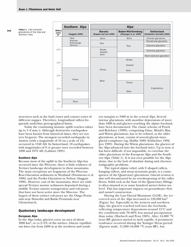
ern margins to 3400 m in the central Alps. Severalintense glaciations, with snowline depressions of morethan 1000 m and glaciers reaching the alpine foreland,have been documented. The classic scheme of Penckand Brückner (1909), comprising Günz, Mindel, Riss,and Würm glaciations, has to be refined, as the olderglaciations, at least, consist of several glacial–inter-glacial complexes (eg, Habbe 1989; Schlüchter 1992;Jerz 1993). During the Würm glaciations, the glaciers ofthe Alps advanced into the foreland twice. Up to now, ithas been difficult, if not impossible, to correlate theolder glaciations of the European Alps and the South-ern Alps (Table 1). It is not even possible for the Alpsalone, due to the lack of absolute dating and chronos-tratigraphic problems.
The typical alpine relief, with U-shaped valleys,hanging valleys, and steep mountain peaks, is a conse-quence of the Quaternary glaciations. Glacial erosion isalso well documented by an overdeepening of the valleyfloors. Solid rock as the base of the Quaternary fillingsis often situated at or some hundred meters below sealevel. This has important impacts on groundwater flowand tunnel construction.
During the Last Glacial Maximum (LGM), the ice-covered area of the Alps increased to 126,000 km2
(Figure 3a). Especially in the western and northernAlps, the glaciers reached well into the forelands,reflecting temperature depressions around 15°C anddry conditions with 70–80% less annual precipitationthan today (Haeberli and Penz 1985). After 14,000 14Cyears BP, glaciers started to melt rapidly. A prominentreadvance occurred during the Younger Dryas period(Egesen stade, 11,000–10,000 14C years BP), but
TABLE 1 Late Cenozoicglaciations of the Alps andSouthern Alps.
Research
345
already in the early Holocene, snowlines and treelinesreached modern altitudes.
At the end of the last glaciation (Würm), the over-steepened and almost vegetation-free slopes led to wide-spread mass movements. Besides till and fluvioglacialsediments, the valleys are therefore characterized byrockfalls and debris cones. The largest rockfallsoccurred in the limestone areas, such as the FlimserRockfall in Switzerland, which is the largest one in theAlps (12 km3; Abele 1974). Up to now, the Rhine Riverhas cut a 600-m-deep canyon into these probably late-glacial deposits. In the crystalline areas, rockfalls aresmaller, the largest being the Early Holocene KöfelsRockfall in Austria (2 km3). Many rockfalls initiateddebris flow and catastrophic floods.
During the Holocene, 8–9 prominent glacieradvances took place, reflecting altitudinal variations inthe glacier equilibrium lines in the order of ±100 m(Patzelt and Bortenschlager 1973; Maisch et al 2000),accompanied by variations in treeline of the same mag-nitude. The last high stand occurred around 1850 ADat the end of the Little Ice Age. Since then, the ice vol-ume of the glaciers has diminished in the order of 50%,mainly due to atmospheric warming. This correspondsto a 30–40% decrease in the glacierized area. This,together with warming of the permafrost and an accom-panying rise in the elevation of the lower permafrostlimit, might lead to increased instability of the slopesand accelerated activity of debris flows in the future
(Haeberli et al 1997). Aside from glaciers and treelines,a relatively warm Holocene Climatic Optimum between8000 and 5000 14C years BP is represented by well-devel-oped soils and reduced periglacial activity above thetreeline (Gamper 1981; Steinmann 1978; Veit 1993; Veitand Höfner 1993).
Southern AlpsExamination of the landscape of the Southern Alpsdemonstrates that the mountains have experiencedmultiple glaciation recorded by the large glacially erod-ed troughs and multiple belts of lateral and endmoraines that lie well beyond the present glaciers.Today the regional snowline lies between about 1500 min the southwest and about 1900 m in the central SouthIsland, and over 3000 glaciers have been identified(Chinn 1989). The glaciers cover about 116 km2, whichis about 5% of the land area of the South Island. Dur-ing the Pleistocene, a large, complex glacier systemconsisting of expanded valley and piedmont glaciersextended 700 km along the Southern Alps (Figure 3b)and averaged 100 km in width (New Zealand GeologicalSurvey 1973). The longest continuous record of glacia-tion in the Southern Alps comes from a core drilledfrom the sea floor about 300 km off the east coast of theSouth Island. This site, known as Deep Sea Drilling Pro-gramme (DSDP) site 594, consists of alternating layersof pelagic sediment derived from free-swimming marineorganisms and hemipelagic deposits that consist in part
FIGURES 3A AND B (a) Pleistocene glaciation of the Alps, based on Glückert (1987) and Lister et al(1998). (Map by Andreas Brodbeck) (b) Geological survey (New Zealand Geological Survey 1973).(Map by Bill Mooney)
Sean J. Fitzsimons and Heinz Veit
Mountain Research and Development Vol 21 No 4 Nov 2001
346
of sediments derived from the Southern Alps (Nelsonet al 1985). Analysis of the top 100 m of the core hasyielded an apparently uninterrupted record of sedimen-tation that records 12 major periods of alpine glaciationover the last 730,000 years. In contrast, only 6 majorperiods of ice advance can be recognized in the terres-trial record of glaciation of the Southern Alps. The 2oldest reconstructed ice advances (the Ross and Porikaglaciations), known from evidence in south Westlandand Nelson, are thought to have occurred in the latePliocene. The next 4 glaciations (the Nemona,Waimaunga, Waimea, and Otira glaciations) occurredin the middle and late Pleistocene and are best knownin north Westland (Suggate 1990). Comparison of theterrestrial model of glaciation with information fromDSDP 594 suggests that the 1.75-million-year gapbetween the late Pliocene and middle Pleistoceneglaciations is an indication that much of the terrestrialevidence of glaciation is missing. This gap in the recordhas been attributed to the combined effects of uplift ofthe Southern Alps and erosion. However, recent appli-cations of uranium series and paleomagnetic datinghave suggested that at least some of the depositsthought to be middle Pleistocene in age are much old-er. Thus, they are likely to lie within the period thatconstitutes this gap in the terrestrial record (McSaveneyet al 1992; Fitzsimons et al 1996).
There is widespread evidence of numerous iceadvances since the LGM, including deposits thought tocorrelate with the Younger Dryas event in Europe. Thechronology of the post-LGM events has been reviewedby Fitzsimons (1997).
As well as resulting in uplift, the interactions of thePacific and Indo-Australian Plates cause earthquakes.One outcome of large earthquakes is the triggering ofrockfalls and landslides, which are widespread through-out the Southern Alps. The distribution of coseismiclandslides has been used to estimate the timing andintensity of prehistoric earthquakes. Using the growthof lichens on rock debris from 3 events, Bull (1996)suggested that the Cook segment of the Alpine Faultruptures regularly about every 260 years. The last eventoccurred in 1748 ±10 AD.
The largest documented subaerial landslide onearth is the Green Lake Landslide, which occurred onthe southern end of the Hunter Mountains in Fiord-land about 13,000 years ago. This landslide has an areaof 45 km2 and involved the movement of about 27 km3
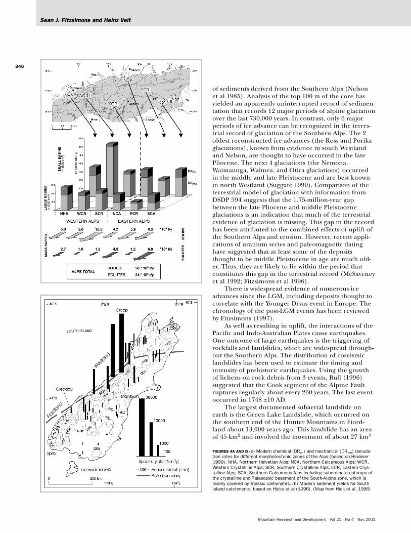
FIGURES 4A AND B (a) Modern chemical (DRch) and mechanical (DRme) denuda-tion rates for different morphotectonic zones of the Alps (based on Hinderer1999). NHA, Northern Helvetian Alps; NCA, Northern Calcareous Alps; WCR,Western Crystalline Alps; SCR, Southern Crystalline Alps; ECR, Eastern Crys-talline Alps; SCA, Southern Calcareous Alps including subordinate outcrops ofthe crystalline and Palaeozoic basement of the South-Alpine zone, which ismainly covered by Triassic carbonates. (b) Modern sediment yields for SouthIsland catchments, based on Hicks et al (1996). (Map from Hick et al, 1996)
Research
347
of material from the collapse of a 9-km section on a1500-m-high ridge (Hancox and Perrin 1994). Thematerial moved 2.5 km laterally and 700 m verticallyinto a deep glacial trough where an 800-m-high damwas formed. The failure was thought to have been trig-gered by a large (>M 7.5) earthquake.
On the eastern side of the Southern Alps, the lowerparts of several glaciers are debris-covered because rockavalanches from the valley sides deposit large quantitiesof debris on the glaciers (Figure 5b). A good exampleof this process was provided by the debris avalanchethat occurred on the northern face of Aoraki-MountCook on 14 December 1991. The rock avalancheinvolved approximately 14 million m3 of rock thatflowed across Tasman Glacier and up to 70 m above theglacier on the opposite wall of the valley (Chinn et al1992).
Contemporary landscape development
The calculation of modern denudation rates for a wholemountain range is complicated. Most data come fromsmall catchments and experiment plots. On the otherhand, modern suspended loads and bedloads of largerivers may be affected by human impact and upstreamsediment storage. In addition, contemporaneous moni-toring of solid and dissolved load is rarely undertaken.
European AlpsBased on studies of sediment yields in rivers and sedi-ment budgets in reservoirs of various size, Hinderer(1999, 2001) estimates mechanical denudation ratesbetween 100–650 mm/ky for different morphotectoniczones of the Alps (Figure 4a). The highest rates areobserved in the Western Crystalline Alps (WCR), where-as the Northern Calcareous Alps (NCA) exhibit the low-est rates. Specific sediment yield of large catchments isless than half of that from small catchments, implyingimportant intermittent storage of sediments in pedi-ments and floodplains. Hence, denudation rates calcu-lated from the sediment load of large rivers do not rep-resent effective denudation rates in the headstreamareas. Based on the sediment export of large rivers, themodern area-weighted mean denudation rate of theAlps is about 0.125 mm/y, which corresponds to a massexport of 50 million t/y. Dissolved load accounts for anadditional mass export of 24 million t/y, ie, one third ofthe total load. Due to different calculation methods,the denudation rates in Figure 4a are not directly com-patible with the specific sediment yields of the South-ern Alps (Figure 4b).
Southern AlpsThe Southern Alps of New Zealand form asouthwest–northeast trending barrier that lies across
the prevailing westerly circulation in the middle lati-tudes of the Pacific Ocean. Orographic uplift of themaritime winds results in extremely high precipitationon the west coast and a steep precipitation gradientinto the rainshadow areas to the east of the maindivide. The maximum precipitation falls in a zone par-allel to the first range a few kilometers west of the maindivide and peaks at around 12,000 mm/y (Griffiths andMcSaveney 1983). Within 10 km east of the main divide,the precipitation falls to less than 300 mm/y. The inter-
FIGURES 5A AND B (a) Mont Blanc (4807 m), the highest peak in the Euro-pean Alps with the Glacier des Bossons near Chamonix. The glacier retreatfrom the recent moraines of the 19th century is clearly visible. Geologically,Mont Blanc belongs to the prealpidic crystalline Hercynian basement. The peakat the left is the Aiguille du Midi (3842 m), accessible by cable car. For loca-tion, see Figure 1. (Photo by Heinz Veit, 18 July 2000). (b) The highest peak inthe Southern Alps is Aoraki/Mount Cook (3754 m). Also shown is TasmanGlacier, which is covered with rock avalanche debris from the Mount CookRange. The lake at the terminus of Tasman Glacier has developed as the icehas retreated from the late 19th century position at the present day source ofthe Tasman River. (Photo by Trevor Chinn, 1998)
Sean J. Fitzsimons and Heinz Veit
Mountain Research and Development Vol 21 No 4 Nov 2001
348
action of the tectonic setting and the westerly circula-tion has an important impact on landscape develop-ment (Whitehouse 1988).
In New Zealand, there has been considerabledebate about the controls of contemporary erosionprocesses, and several studies have suggested that rain-fall is the major control on denudation rates. In a studyof South Island catchments, Griffiths (1979, 1981) con-cluded that rivers draining the western Southern Alpshave suspended sediment yields that are about 10 timeshigher than world average rates for mountainous areas.He suggested that almost all the variations in sedimentyield are explained by variations in mean annual rain-fall. In another study, Adams (1980) argued that lithol-ogy, tectonic uplift rates, and Quaternary geomorpho-logical history including glaciation were also importantcontrols on sediment yields. In yet another study, Pick-rill (1993) examined sediments that have accumulatedin fiords and suggested that sediment yields rangedfrom 28 to 209 t/km2/y, in comparison with Griffiths’figure of 13,300 t/km2/y for the Cleddau River, whichflows into Milford Sound. More recently, Hicks et al(1996) examined a larger, updated data set for 203 NewZealand catchments and found that average annual sed-iment yields vary over 4 orders of magnitude, from lessthan 20 t/km2/y to almost 30,000 t/km2/y (Figure 4b).This study concluded that the main controls on sedi-ment yield are mean annual rainfall and basin geology,which includes lithology, the level of tectonic activity,and the Quaternary history of the catchment. The highsediment yields from the west coast are a consequenceof the combined effects of the high mountains and thehigh orographic precipitation produced by the interac-tion of the mountains with the prevailing westerlyairstream (Whitehouse 1988).
Whitehouse (1988) suggested that 3 geomorpho-logical regions can be identified in the Southern Alpson the basis of distinct landform assemblages and ero-sion processes. These regions are the western SouthernAlps, which are characterized by extremely steep,intensely dissected slopes formed by fluvial erosion anddebris avalanches; the axial Southern Alps, which aredominated by high glaciated mountains; and the east-ern Southern Alps, which can be divided into a basinand range subregion and an eastern front range subre-gion. The basin and range subregion consists of moder-ately dissected, scree-covered ranges separated by largevalleys with braided rivers, while the eastern front
ranges subregion consists of dissected greywacke moun-tains with rounded ridge crests and V-shaped valleys.Identification of these geomorphological regions recog-nizes that the form of the land surface is an expressionof the endogenic and exogenic processes that currentlyoperate and the processes that have operated in therecent geological past.
Conclusions
Both the Alps and Southern Alps are high mountainareas that are products of plate collisions. Both moun-tain ranges have high relief, and their landscapes havebeen imprinted by multiple glaciation during the Qua-ternary. However, the similarities are to a large extentsuperficial. The geological and structural evolution ofthe mountains, together with rates of uplift anddenudation, are quite distinct.
Although both mountain ranges are the product ofplate collisions, the Alps are structurally and lithologi-cally considerably more complex than the SouthernAlps. The structural and lithologic complexity is a con-sequence of the mosaic of terrains that were deformedtogether as parts of the European Plate, an ocean floor,and part of the African Plate collided and produced aseries of overthrust nappes. The relative structural andlithologic simplicity of the Southern Alps is a conse-quence of the linear nature of the boundary betweenthe Pacific and Indo-Australian Plates and the youth ofthe orogeny. It is also due to the fact that the vast bulkof the deformed rocks are derived from a singlesource—the New Zealand Geosyncline.
The current uplift rates in the Alps are in the orderof 1–2 mm/y, whereas the Southern Alps experience ratesat a greater order of magnitude because the strain acrossthe Pacific and Indo-Australian Plate boundaries is veryhigh. The high uplift rates in the Southern Alps appear tobe matched by similarly high denudation rates. The highdenudation rates are a consequence of the maritime loca-tion of the Southern Alps and their geometrical relation-ship to a westerly dominated atmospheric circulation sys-tem that gives rise to very high orographic precipitation.The high precipitation in parts of the Southern Alpstogether with the high relief, deformed rocks, and seismi-cally active environment combine to produce rates ofdenudation that peak several orders of magnitude higherthan those experienced in the Alps.
AUTHORS
Sean J. FitzsimonsDepartment of Geography, University of Otago, PO Box 56, Dunedin, [email protected]
Heinz VeitInstitute of Geography, University of Berne, Hallerstrasse 12,CH-3012 Berne, [email protected]
Research
349
REFERENCES
Abele G. 1974. Bergstürze in den Alpen. WissenschaftlicheAlpenvereinshefte 25. Munich: German and Alpine Clubs.Adams J. 1980. Contemporary uplift and erosion of the Southern Alps,New Zealand. Geological Society of America Bulletin 91:1–114.Bull WB. 1996. Prehistorical earthquakes on the Alpine Fault, NewZealand. Journal of Geophysical Research 101:6037–6050.Bull WB, Cooper A. 1986. Uplifted marine terraces along the Alpine Fault,New Zealand. Science 234:1225–1228.Chinn TJH. 1989. Glaciers of New Zealand. In: Allison I, Peterson JA, ChinnTJH, editors. Glaciers of Irian Jaya, Indonesia and New Zealand.Washington, DC: US Government Printing Office, pp H21–H48.Chinn TJH, McSaveney MJ, McSaveney ER. 1992. The Mount Cook rockavalanche of 14 December 1991. Information Brochure. Wellington, NewZealand: Institute of Geological and Nuclear Sciences.Doppler G, Jerz H. 1995. Untersuchungen im Alt- und Ältestpleistozän desbayerischen Alpenvorlandes—Geologische Grundlagen undstratigraphische Ergebnisse. Geologica Bavarica 99:7–53.Ellwanger D, Bibus E, Bludau W, Kösel M, Merkt J. 1995. Baden-Württemberg. In: Benda L, editor. Das Quartär Deutschlands. Berlin:Borntraeger, pp 255–295.Fitzsimons SJ. 1997. Late glacial and early Holocene glacier activity in theSouthern Alps, New Zealand. Quaternary International 38:69–76.Fitzsimons SJ, Pollington M, Colhoun EA. 1996. Palaeomagneticconstraints on the ages of glacial deposits in North-West South Island,New Zealand. Zeitschrift für Geomorphologie 105:7–20.Frisch W. 1982. Entwicklung der Alpen. Geographische Rundschau34:418–421.Gamper M. 1981. Heutige Solifluktionsbeträge von Erdströmen undklimamorphologische Interpretation fossiler Böden. Ergebnisse derwissenschaftlichen Untersuchungen im Schweizerischen NationalparkXV(79):355–443.Glückert G. 1987. Zur letzten Eiszeit im alpinen und nordeuropäischenRaum. Geographica Helvetica 42:93–98.Griffiths GA. 1979. High sediment yields from major rivers of the westernSouthern Alps, New Zealand. Nature 282:61–63.Griffiths GA. 1981. Some suspended sediment yields from South Islandcatchments of New Zealand. Water Resources Bulletin 17:662–671.Griffiths GA, McSaveney MJ. 1983. Distribution of mean annualprecipitation across some steepland regions of New Zealand. New ZealandJournal of Science 26:197–209.Gwinner MP. 1978. Geologie der Alpen. Stuttgart: Schweizerbart.Habbe KA. 1989. Die pleistozänen Vergletscherungen des süddeutschenAlpenvorlandes. Mitteilungen der Geographischen Gesellschaft (Munich)74:27–51.Haeberli W, Penz U. 1985. An attempt to reconstruct glaciological andclimatological characteristics of 18 ka BP ice age glaciers in and aroundthe Swiss Alps. Zeitschrift für Gletscherkunde und Glazialgeologie21:351–361.Haeberli W, Wegmann M, Vonder Mühll D. 1997. Slope stability problemsrelated to glacier shrinkage and permafrost degradation in the Alps.Eclogae Geologicae Helvetiae 90:407–414.Hancox GT, Perrin ND. 1994. Green Lake landslide: a very large ancientlandslide in glaciated terrain. Science Report 93/18. Wellington, NewZealand: Institute of Geological and Nuclear Sciences.Hicks DM, Hill J, Shankar U. 1996. Variation of suspended sediment yieldsaround New Zealand: the relative importance of rainfall and geology. In:Erosion and Sediment Yield: Global and Regional Perspectives. Proceedingsof the Exeter Symposium, July 1996. Wallingford: IAHS Press, pp149–156.Hinderer M. 1999. Klimagesteuerte Denudations-Sedimentakkumulations-Systeme: Massenbilanzen, Modellierung und Anwendung [postdoctoralthesis]. Tübingen: University of Tübingen.Hinderer M. 2001. Late Quaternary denudation of the Alps, valley and lakefilling, and modern river loads. Geodinamica Acta 14:1–33.Jerz H. 1993. Das Eiszeitalter in Bayern. Stuttgart: Schweizerbart.
Kamp PJJ. 1992. Tectonic architecture of New Zealand. In: Soons JM,Selby J, editors. Landforms of New Zealand. 2nd ed. Auckland: Longman,pp 1–30. Kamp PJJ, Green PF, White SH. 1989. Fission track analysis revealscharacter of collisional tectonics in New Zealand. Tectonics 8:169–195.Kamp PJJ, Tippett JM. 1993. Dynamics of the Pacific Plate crust in theSouth Island (New Zealand) zone of oblique continent–continentconvergence. Journal of Geophysical Research 98:16105–16118.Koons PO. 1989. The topographic evolution of collisional mountain belts: anumerical look at the Southern Alps, New Zealand. American Journal ofScience 289:1041–1069.Labhart TP. 1995. Geologie der Schweiz. Thun: Ott.Lichtenecker N. 1926. Die Rax. Geographischer Jahresbericht ausÖsterreich 18. Vienna: Geographical Institute, pp 150–170.Lister GS, Livingstone DA, Amman B, et al. 1998. Alpine Paleoclimatology.In: Cebon P, Dahinden U, Davies H, Imboden D, Jaeger C, editors. Viewsfrom the Alps. Cambridge, MA: The MIT Press, pp 73–169.Maisch M, Wipf A, Denneler B, Battaglia J, Benz C. 2000. Die Gletscher derSchweizer Alpen. Zurich: vdf, pp 1–373.McSaveney MJ, Thompson R, Turnbull IM. 1992. Timing of relief andlandslides in Central Otago. In: Bell DH, editor. Landslides. Proceedings ofthe 6th International Symposium, 10–14 February 1992. Rotterdam:Balkema, pp 1451–1456.Nelson CS, Hendy CH, Jarrett GR, Cuthbertson AM. 1985. Nearsynchroneity of New Zealand alpine glaciations and Northern Hemispherecontinental glaciations during the past 750 kyr. Nature 318:361–363.New Zealand Geological Survey. 1973. Quaternary Geology—South Island.1:1,000,000 map. Miscellaneous map series, map 6. Wellington, NewZealand: New Zealand Geological Survey.Patzelt G, Bortenschlager S. 1973. Die postglazialen Gletscher- undKlimaschwankungen in der Venedigergruppe (Hohe Tauern, Ostalpen).Zeitschrift für Geomorphologie, Neue Folge 16:25–72.Penck A, Brückner E. 1909. Die Alpen im Eiszeitalter. Leipzig: Tauchnitz.Pfiffner OA, Lehner P, Heitzmann P, Müller S, Steck A. 1997. DeepStructure of the Swiss Alps. Basel: Birkhäuser.Pfiffner OA. 1992. Alpine orogeny. In: Blundell D, Freeman R, Mueller S,editors. A Continent Revealed. The European Geotraverse. Cambridge:Cambridge University Press, pp 180–190.Pickrill RA. 1993. Sediment yields in Fiordland. Journal of Hydrology (NewZealand) 31:39–55.Schlüchter C. 1992. Terrestrial Quaternary Stratigraphy. QuaternaryScience Reviews 11:603–607.Schlüchter C, Kelly M. 2000. Das Eiszeitalter in der Schweiz. Berne:Geological Institute.Steinmann S. 1978. Postglaziale Reliefgeschichte und gegenwärtigeVegetationsdifferenzierung in der alpinen Stufe der Südtiroler Dolomiten(Puez- und Sellagruppe). Landschaftsgenese und Landschaftsökologie2:1–93.Suggate RP. 1990. Pliocene and Pleistocene glaciations of New Zealand.Quaternary Science Reviews 9:175–198.Tippett JM, Kamp PJJ. 1995. Geomorphic evolution of the Southern Alps,New Zealand. Earth Surface Processes and Landforms 20:177–192.Tollmann A. 1986a. Geologie von Österreich. Vienna: Deuticke.Tollmann A. 1986b. Die Entwicklung des Reliefs der Ostalpen. Mitteilungender Österreichischen Geographischen Gesellschaft 128:62–72.Veit H. 1993. Holocene solifluction in the Austrian and southern TyroleanAlps: dating and climatic implications. In: Frenzel B, editor. Solifluction andClimatic Variation in the Holocene. ESF Project European Palaeoclimate andMan 6, Paläoklimaforschung 11. Stuttgart: Fischer, pp 23–32.Veit H, Höfner T. 1993. Permafrost, gelifluction and fluvial sedimenttransfer in the alpine/subnival ecotone, central Alps, Austria: present, pastand future. Zeitschrift für Geomorphologie, Neue Folge 92:71–84. Whitehouse IE. 1988. Geomorphology of the central Southern Alps, NewZealand: the interaction of plate collision and atmospheric circulation.Zeitschrift für Geomorphologie 69:105–116.


![[Fitzsimons] Nonconscious Influences on Consumer C](https://static.documents.pub/doc/80x56/54615686af79593a708b59b0/fitzsimons-nonconscious-influences-on-consumer-c.jpg)


