19
Section 24M(3) Exemption Motivation Report for the Continuous Ash Disposal at Matimba Power Station, Lephalale, Limpopo Province Draft May 2016

Section 24M(3) Exemption Motivation Report for the
Continuous Ash Disposal at Matimba Power Station, Lephalale,
Limpopo Province
Draft May 2016

i
Document Description
Document title: Section 24M(3) Exemption Motivation Report for the Continuous Ash Disposal at Matimba Power Station, Lephalale, Limpopo Province Status: Draft_Ver2 Date: May 2016 Project name: Section 24M(3) Exemption Motivation Report for the Continuous Ash Disposal at Matimba Power Station, Lephalale, Limpopo Province Project number: E02.JNB.001222 Client: Eskom Holdings SOC Ltd
Reference: TBD
Drafted by: Prashika Reddy Checked by: Malcolm Roods Date/initials check: May 2016 Approved by: Malcolm Roods Date/initials approval: May 2016

ii
Table of Contents
1 Introduction ................................................................................................................. 1
1.1 Background ......................................................................................................................................... 1
1.2 Key Objectives and Motivation for the Exemption Application ........................................................... 1
1.3 Details of the Applicant ....................................................................................................................... 2
2 Legal Framework ........................................................................................................ 2
3 Activity Description .................................................................................................... 3
4 Description of the Receiving Environment ............................................................... 4
4.1 Site Geology ....................................................................................................................................... 4
4.2 Climatic Water Balance....................................................................................................................... 5
4.3 Geohydrology ...................................................................................................................................... 6
4.4 Surface Water ..................................................................................................................................... 9
4.5 Visual ................................................................................................................................................ 10
5 Public Participation................................................................................................... 11
6 Conclusions and Recommendations ...................................................................... 12
6.1 Mitigation Measures .......................................................................................................................... 12
List of Tables
Table 1: Timeframes anticipated for the construction of the liner for Matimba ash disposal facility .................. 2 Table 2: Applicant details ................................................................................................................................... 2 Table 3: Responsible Party Details .................................................................................................................... 2 Table 4: Relevant environmental legislation applicable to the exemption application ....................................... 3 Table 5: Public participation requirements according to Regulation 4(3) – 4(5) and 6(4) of the National
Exemption Regulations .................................................................................................................................... 11
iii
List of Figures
Figure 1: Map of area covered by this exemption application (SA1) ................................................................. 4 Figure 2: Geological patterns of the study area ................................................................................................. 5 Figure 3: Localities of hydrocensus boreholes – SA1 ........................................................................................ 6 Figure 4: Electrical Conductivity (EC) and Sulphate contour map – existing ADF ............................................ 8 Figure 5: Surface water features and riparian corridors associated with SA1 ................................................. 10
Appendices
Appendix A: Declaration by the Applicant

iv
Acronyms
ADF Ash Disposal Facility
DEA Department of Environmental Affairs
DWS Department of Water and Sanitation
EIA Environmental Impact Assessment
EIAR Environmental Impact Assessment Report
FEIAR Final Environmental Impact Assessment Report
GN Government Notice
GN R Government Notice Regulation
I&AP Interested and Affected Party
IEA Integrated Environmental Authorisation
SA Site Alternative
SMP Stormwater Management Plan

1
1 Introduction
1.1 Background
Matimba Power Station, in Lephalale, Limpopo Province, is a 3990 MW installed capacity base load coal-
fired power station, with six generating units. Matimba is a direct dry cooling power station, an innovation
necessitated by the severe shortage of water in the area where this station is situated. The station obtains its
coal from Exxaro’s Grootegeluk Colliery for the generation of electricity.
Ash is generated as a by-product from combustion of coal from the power station and Matimba produces
approximately 6 million tons of ash annually. This ash is disposed of by means of ‘dry ashing’, at an ash
disposal facility approximately 3 km south of station.
An Environmental Impact Assessment (EIA) study was initiated in 2012 for the development of an additional
ash disposal facility (ADF) and associated infrastructure, which could either be a continuation of the existing
facility or a new facility for the next 39 years of operation of the power station. To cater for this amount of
ash, a 700 ha footprint is required.
Two site alternatives were identified and assessed in the EIA study:
Site Alternative 1 (SA1) – located south of Matimba Power Station the farm Zwartwater 507 LQ. Part of
this farm is currently utilized as an ADF.
Site Alternative 2 (SA2) - located north of Matimba Power Station and straddles four different farms
namely Vooruit 449 LQ, Appelvlakte 448 LQ, Droogeheuvel 447 LQ and Ganzepan 446 LQ. As SA2 is a
greenfields site in its entirety, a new conveyor belt system as well as access road (linear infrastructure
route) would have to be developed in order to transport ash to the new ADF.
Through a comparative assessment of the site alternatives, the Environmental Assessment Practitioner
(EAP) recommended SA1 to be authorised1. The conceptual design for SA1 proposes that approximately
one third of the new ADF (190 ha) is established over the existing ADF, using a “piggy-backing” concept as
an optimisation strategy. The remaining 510 ha will be constructed over a greenfields portion of the farm
Zwartwater 507LQ. Therefore, the total footprint area required for the ADF development, 700 ha, comprises
510 ha on greenfields and 190 ha on top of the existing ADF, creating an airspace of 325 000 000 m3.
The Integrated Environmental Authorisation application and the final EIA Report (FEIAR) are currently
awaiting a decision from the Department of Environmental Affairs (DEA) – Ref 14/12/16/3/3/3/56.
1.2 Key Objectives and Motivation for the Exemption Application
Ash is classified as a Type 3 waste in terms of the DEA National Norms and Standards for Disposal of
Waste to Landfill (GN R. 636, 2013). The specified base lining system is a Class C system. Due to the
processes that need to be followed and the timeframes required for preparation of the footprint and
construction of the liner system, this application is for approval of continuing with current ashing operating
procedures and practices until the liner is fully installed in 5 years’ time. The detailed breakdown of the
5 years is presented in Table 1 below. This continuation being applied for requires 95.5 ha of ground ashing
space to support continuation of operations at the station for the 5 years.
The motivation for exemption provided herein is based on findings of specialist assessments (e.g.
geohydrology, surface water and visual) conducted for the EIA study of the same facility.
1 Royal HaskoningDHV, 2015. Final Environmental Impact Assessment Report for the Proposed Continuous Ash
Disposal Facility for the Matimba Power Station in Lephalale, Limpopo Province.
2
Table 1: Timeframes anticipated for the construction of the liner for Matimba ash disposal facility
Task Expected Timeframes Status
Conceptual Design December 2015 Complete and submitted to DEA for approval
Integrated Environmental Authorisation (IEA) Water Use Licence (WUL)
End April 2016 18 months
Final EIR submitted in December 2015 with the IEA expected end April 2016 WULA to be submitted on 29 June 2016 Decision is expected in January 2018
Detailed Design End September 2018 According to the most recent schedule, designs go until June 2018 and Works Information until September 2018. Thus, the Detailed Design Phase ends in September 2018.
Procurement 18 Months April 2019
Construction June 2019 – May 2021 According to the current schedule, construction will commence in June 2019 and be completed in May 2021
1.3 Details of the Applicant
The details of the Applicant and Responsible Party are provided in Table 2 and Table 3 below:
Table 2: Applicant details
Details
Name of Applicant: Eskom Holdings SOC Ltd
Contact Person: Deidre Herbst
Postal Address PO Box 1091, Johannesburg, 2001
Telephone: 011 800 3501
Facsimile: 086 660 6092
E-mail: [email protected]
Table 3: Responsible Party Details
Details
Name of Power Station: Matimba Power Station (Eskom Holdings SOC Ltd)
Contact Person: Rhulani Mathebula (Power Station Manager)
Postal Address Private Bag X215, Lephalale, Limpopo, 0555
Telephone: 014 763 8598
Facsimile: 086 539 2279
E-mail: [email protected]
The declaration by the Applicant is provided in Appendix A.
2 Legal Framework This Exemption Application is made in terms of Regulations 3 and 4 of the National Exemption Regulations
(No R.994) read with Section 24M(3) of National Environmental Management Act (Act No 107 of 1998) and
Section 74 of the NEM: Waste Act (Act No 59 of 2008) and specifically requests exemption from complying
with GN R. 636 during the 5 year period from when the project is authorised until the construction and
implementation of the prescribed liner.
The relevant environmental legislation applicable to the Exemption Application is presented in Table 4
below.

3
Table 4: Relevant environmental legislation applicable to the exemption application
Legislation Section/Chapter/Regulation Relates to
National Environmental Management Act (No 107 of
1998 [as amended]) Section 24M
Provides for the prohibition, restriction and control of activities which are likely to have a detrimental effect on the environment
National Environmental Management: Waste Act (No.
59 of 2008) Section 74, Part 3
Exemptions and Appeals
National Water Act (No 36 of 1998)
Chapter 3 Protection of water resources
Section 19 Pollution prevention (Prevention and remedying effects of pollution)
Chapter 4, Section 21 General principles for regulating water use
GN 704 Regulations on use of water for mining and related activities aimed at the protection of water resources
3 Activity Description Ash is classified as a Type 3 waste in accordance with the DEA National Norms and Standards for Disposal
of Waste to Landfill (GN R. 636, 2013). The specified liner is a Class C and is proposed over greenfield
areas.
In line with the recommendation for Site 1 (SA 1) to be authorised in the Matimba Continuous Ashing Facility
FEIR, the area that will not be lined during the 5 year period is estimated to be approximately 95.5 ha. The
orange-bounded area (E-F-G-H-I) is the area that will be covered in ash, placed by the main system shiftable
conveyor and is approximately 55.1 ha (Figure 1). The red-bounded area (A-B-C-D) placed by the standby
system shiftable conveyor, is 40.4 ha (Figure 1).

4
Figure 1: Map of area covered by this exemption application (SA1)
4 Description of the Receiving Environment
4.1 Site Geology
An 8 km buffer area was assessed during the geological investigations. The existing Matimba ADF as well
as the area covered by the exemption application is underlain by the Mogalakwena Formation of the
Waterberg Group (Figure 2). The formation is comprised of coarse grained purplish brown sandstone. The
host formation, in its unweathered state, has limited storativity and transmissivity, thus groundwater
movement will be reduced unless if secondary processes associated with faults occurred in the area. No
major faults were mapped down-gradient of the existing ADF based on the geological data interpretation and
also based on the geophysical data interpretation. .
The Eenzaamheid Fault separates the Waterberg Group in the south from the Karoo Supergroup sediments
underlying the remainder of the 8 km buffer area to the north. The Swartrant and Grootegeluk Formations of
the Karoo Supergroup are located in the central, western and eastern portions. The Swartrant Formation
consists of sandstone, gritstone, mudstone and coal and the Grootegeluk Formation consists of mudstone,
carbonaceous shale and coal.
The Daarby Fault separates the Swartrant Formation from the Clarens Formation to the north of the buffer
area. The Clarens Formation consists of fine grained cream coloured sandstone.
Geological structures such as faults can either enhance or impede the groundwater potential in the area by
increasing the permeability and transmissivity of the host rock. Faults can also act as a preferential flow path
for groundwater and potential contamination. Any possible contaminant sources such as ADFs should not be
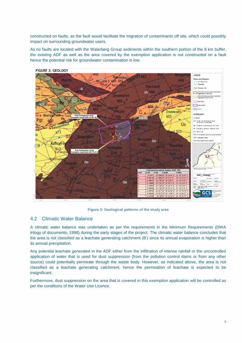
5
constructed on faults, as the fault would facilitate the migration of contaminants off site, which could possibly
impact on surrounding groundwater users.
As no faults are located with the Waterberg Group sediments within the southern portion of the 8 km buffer,
the existing ADF as well as the area covered by the exemption application is not constructed on a fault
hence the potential risk for groundwater contamination is low.
Figure 2: Geological patterns of the study area
4.2 Climatic Water Balance
A climatic water balance was undertaken as per the requirements in the Minimum Requirements (DWA
trilogy of documents, 1998) during the early stages of the project. The climatic water balance concludes that
the area is not classified as a leachate generating catchment (B-) since its annual evaporation is higher than
its annual precipitation.
Any potential leachate generated in the ADF either from the infiltration of intense rainfall or the uncontrolled
application of water that is used for dust suppression (from the pollution control dams or from any other
source) could potentially permeate through the waste body. However, as indicated above, the area is not
classified as a leachate generating catchment, hence the permeation of leachate is expected to be
insignificant.
Furthermore, dust suppression on the area that is covered in this exemption application will be controlled as
per the conditions of the Water Use Licence.

6
4.3 Geohydrology
A hydrocensus was conducted as part of the hydrogeological investigation whereby properties within a 2 km
radius of SA1 were visited. A total of 12 existing boreholes were identified (Figure 3), and four new
boreholes were drilled as part of the geohydrological study (MA1 – 4) in support of the integrated licencing
for this project for the SA1 hydrocensus. Of these sixteen (16) boreholes, four (4) were dry (MA3; MA4;
GHT01 and P12). Eleven of the boreholes were monitoring boreholes, only one was a production borehole
(HP01) located north of the ADF. No other groundwater users were identified within a 2 km radius of the
ADF.
Water levels recorded in 11 boreholes ranged from 5.63 to 21.47 mbgl. The production borehole, HP01 is
fitted with a submersible pump, thus no water levels could be measured.
Figure 3: Localities of hydrocensus boreholes – SA1
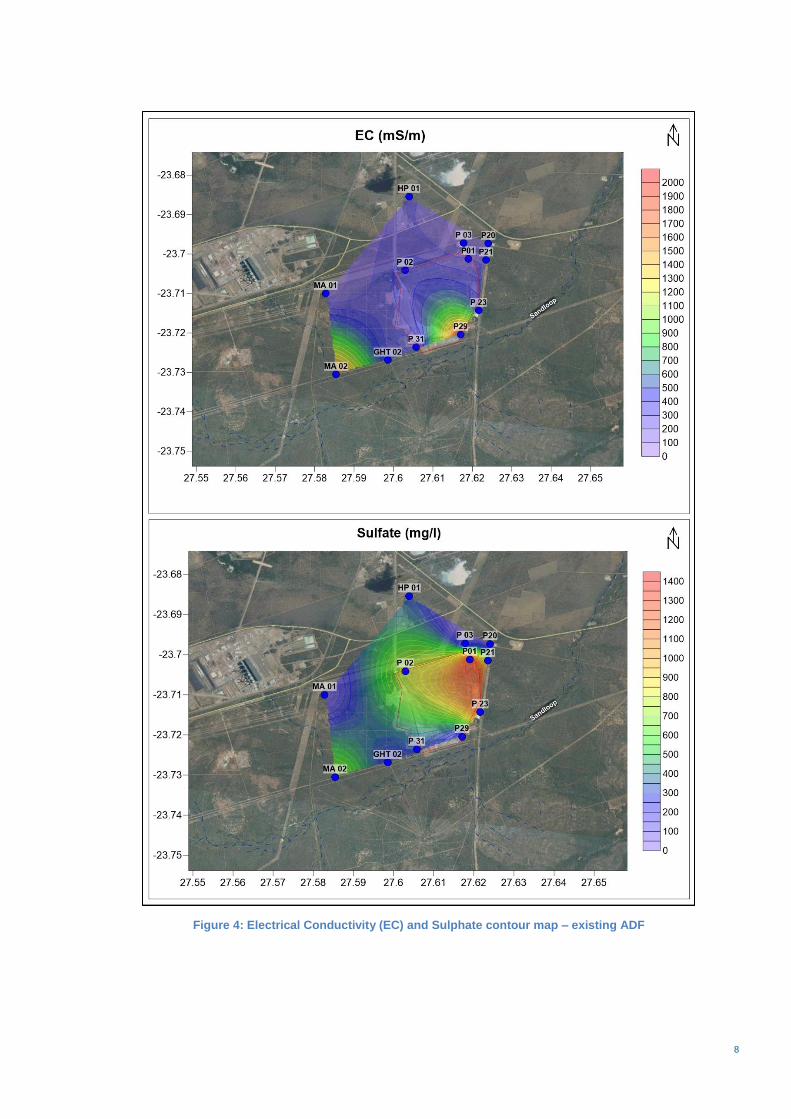
Based on the hydrogeological investigation, contamination is present surrounding the footprint of the ADF
(Figure 4) however monitoring data to date confirm that the impacted areas are localised surrounding the
footprint of the existing ADF.
The groundwater numerical model (quality simulations) for the existing ADF2 confirm that the pollution plume
migrates easterly and north-easterly from the pollution sources in both the shallow and deep aquifers.
Accumulation of pollution may occur within zones of depression to the north-east and south of the ash stack.
The pollution arising from the ADF will remain present until decommissioning of the power station. Numerical
models were simulated another 20 years until closure to illustrate plume movement. Pollutants may
gradually move north-east wards along the base of the non-perennial Sandloop River (situated south and
2 GHT Consulting Scientists, 2015. Numerical Pollution Plume Model Update 2015 – Matimba Power Station.

7
east of the existing ADF) and would reach approximately 2.2 km from the ADF in 20853. It is however
anticipated that the cumulative impact of both the existing and extension of the ADF would not have any
more severe impacts than already present and modelled on the site.
Therefore the impact from the ashing on an unlined surface is anticipated not to have a significant impact on
the migration distance of the existing plume.
3 GHT Consulting Scientists, 2015. Numerical Pollution Plume Model Update 2015 – Matimba Power Station.
8
Figure 4: Electrical Conductivity (EC) and Sulphate contour map – existing ADF
9
4.4 Surface Water
During the EIA phase surface water assessment for the EIA study, two primary surface water risks (potential
impacts) were associated with the expansion of the ADF:
The potential physical transformation of surface water features, including riparian corridors.
The entry of pollutants into surface water features (including riparian zones) transported by stormwater
generated off the ADF.
In order to determine the risk posed by the area undergoing exemption to surface water features, the
distance from the nearest surface water feature receptors to the affected area needs to be examined. Figure
5 indicates the location of the area undergoing exemption in relation to surface water features and their
associated riparian corridors.
It is important to note that the proposed area for which exemption is being sought would not exert a physical
footprint over any surface water feature (including any riparian corridors), and thus no surface water features
would be physically disturbed or any riparian habitat transformed. The orange-bounded area (E-F-G-H-I,
Figure 5) is located closest to the boundary of a surface water feature, with the south-western corner of the
orange-bounded area being located approximately 460 m from the closest point of the boundary of the
Sandloop River riparian corridor located to the south. The closest part of the channel of the Sandloop River
(which carries ephemeral flows) to the proposed exemption area is approximately 555 m.
Run-off from the site will be captured in a down-slope drain system and removed to the Metsimaholo
pollution control dam (PCD) located on the southern side of the existing ADF. Earth stormwater berms will
be created as the ashing face progresses in the area undergoing the exemption application and the existing
operational stormwater management practices will be adhered to.
The distance of the area undergoing exemption to surface water features, allied to the stormwater mitigation
measures presented above will ensure that the risk of entry of polluted stormwater run-off into the nearest
surface water features will be very low.

10
Figure 5: Surface water features and riparian corridors associated with SA1
4.5 Visual
The ADF is an existing structural feature within Lephalale in which the Matimba Power Station is located,
taking on the appearance of a rehabilitated dump and forming part of a cluster of industrial power generation
and related infrastructure in the area. The existing ADF is visually prominent due to its height –
approximately 50 m above natural ground level.
The continued ashing will entail the expansion of the current ADF to the west and south-west of the existing
active ashing face. The height of the proposed area undergoing exemption will be 57 m. Compared to the
height of the existing facility (50 m), the area undergoing exemption will not be significantly higher, and the
viewshed (area from which the ADF is visible) would not increase greatly. The potential visual impact of the
continued ashing will be minimised in that the area undergoing exemption will be largely shielded by the
existing facility when viewed from the east and the north (thus retaining a view of the rehabilitated eastern
and northern side of the facility) – directions in which most visual receptors are located (East receptors –
Eendracht Farmstead and Onverwacht; North receptors – Matimba Power Station; Manketti Lodge;
Marapong).
There are fewer receptor locations to the south and the west (Kuipersbult Farmstead), and these receptor
locations are already visually exposed to the active face of the ADF, thus resulting in little change to the
current visual environment as viewed from these areas. Over time the increased footprint will be rehabilitated
and this factor will assist in the increased footprint blending in with the existing facility which would be
rehabilitated and re-vegetated.
Accordingly the visual impacts of the continued ashing are not expected to be significant.

11
5 Public Participation Public Participation Process (PPP) is conducted in line with the requirements of Regulation 4(3) of the
National Exemption Regulations as well as according to Chapter 6 of the EIA Regulations (2014) - Table 5.
Table 5: Public participation requirements according to Regulation 4(3) – 4(5) and 6(4) of the National Exemption Regulations
Public Participation Requirements Specific Actions to Ensure Compliance
Regulation 4(4) – The written notice must contain the following information:
(a) The name, address and telephone number of the person applying for the exemption;
(b) The provisions from which the exemption is applied for;
(c) A brief description of the exemption applied for and where the application can be viewed or a copy can be obtained from;
(d) The postal address, email address, fax number, contact details of the person applying for the exemption to whom comments must be submitted;
(e) The date on which comments on the exemption application must be submitted, provided that a minimum of 30 calendar days must be allowed for the submission of comments.
Details of the applicant are included in Table 2 of this report.
A 30 calendar day commenting period (18 May 2016 to 20 June 2016) is allowed for I&APs to comment on the Draft Exemption Application Motivation Report.
Regulation 4(5)(a) - Fixing a notice board at a place conspicuous to and accessible by the public at the boundary, on the fence of the site or any alternative site applicable to the application.
Notice boards were placed at the following places:
Marapong Clinic; Marapong Post Office; Marapong Library; Matimba Power Station Security Office; Medupi Power Station turn-off; Mogol Club; Lephalale Public Library and Lephalale Municipal Offices.
Regulation 4(5)(b) - The person conducting a public participation process must give written notice to the occupiers of the site and the owner or person in control of the site; owners and occupiers of land adjacent to the site; municipal councillor; municipality; municipality having jurisdiction; and any organ of state having jurisdiction in respect of any aspect of the activity.
Introductory letters to adjacent landowners, municipal councilor/s, municipality and organs of state were distributed on 18 May 2016.
Section 4(5)(c) & (d) – Place an advert in one local newspaper or official Gazette and or placing an advertisement in at least one provincial newspaper or national newspaper, if the activity has or may have an impact that extends beyond the boundaries of the metropolitan or district municipality.
An advert was placed in the local newspaper (Mogol Post) to advertise the availability of the draft Exemption Application Motivation Report for review and comment.
Section 6(4) (a) & (b) – The applicant must in writing and within 12 calendar days of being notified of the decision, notify any person that submitted comments, objections or oral submissions in relation to the exemption application of – (a) The outcome of the application and the reasons
for the decision; and (b) Draw the attention of any person that submitted
comments, objections or oral submissions to the fact that an appeal may be lodged against the decision in terms of Section 43 of the Act, if such
An advert will be placed in the local newspaper (Mogol Post) to advertise the decision of the exemption application.

12
Public Participation Requirements Specific Actions to Ensure Compliance
appeal is available in the circumstances of the decision.
6 Conclusions and Recommendations This Exemption Application is submitted in terms of Regulations 3 and 4 of the National Exemption
Regulations (No R.994) read with Section 24M(3) of National Environmental Management Act (Act No 107 of
1998) and Section 74 of the NEM: Waste Act (Act No 59 of 2008) and specifically requests exemption from
complying with GN R. 636 (Norms and Standards for the Disposal of Waste to Landfill) during this 5 year
period from when the project is authorised until the construction and implementation of the prescribed liner
system.
The motivation for exemption relies on the following assessments: geohydrology, hydrology, surface water
and visual) conducted during the EIA study for the project. Hydrological, surface water and visual impacts
are considered to be low provided that the mitigation measures presented in Section 6.1 are implemented.
Based on the hydrogeological investigation, it is acknowledged that the current facility has impacted on the
groundwater in the study area since the commencement of disposal, however monitoring data to date
confirm that the impacted areas are localised, surrounding the footprint of the existing ADF. It is therefore
anticipated that the additional impacts of 5 years of ash disposal without the liner system will not result in
significant pollution.
During this time, it is in the country’s best interest that Matimba Power Station continues to operate
according to its current ashing processes, thus ash disposal to continue as per current operating procedures.
This will mean continued ashing on an unlined surface and managing groundwater impacts in the same
manner during this period.
6.1 Mitigation Measures
Mitigation measures, which must be enforced during the 5 year ash disposal, include the following:
Any boreholes located on the site footprint where ash disposal will occur must be backfilled (using a
cement-bentonite slurry) so as to prevent direct migration of potentially poor quality water into the
aquifers and further groundwater pollution. Thus far, borehole B35 has been identified but other
boreholes will have to be verified. The sealing procedure will be finalised with an appointed Contractor.
Prevent excess water on the ADF, dust suppression must be controlled and comply with the Water Use
Licence conditions.
Implementation of a stormwater management plan in compliance with GN 704 of the National Water Act
(Act No 36 of 1998).
Implementation of a groundwater monitoring programme:
To determine the impact on groundwater resources, water quality and levels are required to be
monitored on an on-going basis. If the monitoring data indicates the need for corrective action,
the magnitude of the impact must be assessed by an appropriately qualified and experienced
specialist and the necessary measures put forward based on the magnitude of the impact.
The following boreholes are currently being monitored by GHT Consulting: P01, P03, P02, P31,
P29, P23 and P20. MA01 and MA02 are newly drilled boreholes by GCS. Boreholes GHT01 and
GHT02 are newly drilled boreholes by GHT Consulting and can monitor additional groundwater
impacts associated with the exemption area.
Borehole HP01 is a production borehole used for garden irrigation and stock watering. All these
boreholes should be included in the proposed monitoring plan for SA1. Boreholes MA1 and
HP01 can be monitored bi-annually whereas the remainder of boreholes should be monitored
quarterly as per the conditions of the Water Use Licence.

13
The exemption area should be rehabilitated effectively to minimise ponding and run-off should be
directed away from the ADF.

Appendix A: Applicant Declaration


