SECTION 3 AFFECTED ENVIRONMENT Final Environmental Impact Statement 3-1 Starke U.S. 301 Corridor Study 3.0 AFFECTED ENVIRONMENT This section provides a description of the social, economic and environmental setting of the area affected by the proposed Build Alternatives. The area described includes the vicinity of the proposed Urban Alternative along the existing segment of U.S. 301 (S.R. 200) that begins approximately three miles south of the City of Starke and ends two miles north of the City of Starke. The discussion also includes the area to the west of the City of Starke in Bradford County where the proposed Rural Alternative is located. 3.1 SOCIAL AND ECONOMIC 3.1.1 POPULATION AND COMMUNITY CHARACTERISTICS The City of Starke is a relatively small historic town which began in 1857 as the mid-point on the historic Florida Railroad that ran from Fernandina on the Atlantic Coast to Cedar Key on the Gulf Coast. Starke serves as the county seat in the mostly rural Bradford County, which was established in 1861 when New River County was split in two to form Bradford and Union counties. Today, four state roads (S.R. 200, S.R. 100, S.R. 16, and S.R. 230) pass through mostly undeveloped and rural countryside prior to converging in Starke (see Figure 1.1). Starke is a service and commercial center on U.S. 301. It is at least 30 miles to the nearest interstate service center and 40 miles to the nearest large urban center. Population data from the U.S. Census Bureau’s 2005-2009 American Community Survey 5-Year Estimates is accumulated to provide a general picture of the community characteristics in the immediate project area and to allow comparison among the proposed alternatives. A comparison of the characteristics of Florida, Bradford County and the City of Starke is important in assessing possible socio-economic impacts of the project. The data for these census areas is shown on Table 3.1. The census data indicates that the median age in Bradford County and the City of Starke is lower than the statewide median age. The percentage of persons 65 and older is higher statewide than in the study area. This data is consistent with the data that indicates that average number of persons per family and average household size is larger than the statewide averages. While there are many retirement communities throughout Florida, there are no such large retirement communities in Bradford County or the City of Starke. The percentage of vacant housing units within the city and the county ranges from 12-16%, respectively, which is lower than the statewide average of 18% vacant units. The percentage of renter occupied units is lower in the county than statewide, but higher in the city than the statewide average. The median household value is lower in the area than the statewide average. In Bradford County and the City of Starke, there is a higher percentage of minorities than there is statewide. The per capita income, median household income and median family income is lower in both the city and county than statewide. And there are a much higher percentage of families below the poverty level than statewide. The percentage of high school graduates and college graduates is lower in the area than statewide. Development activity in Bradford County was slow but steady between 1995 and 2005, with a total of 572 housing starts. Development began to slow in 2006. However, the population, employment and income have continued to increase.
Transcript
SECTION 3 AFFECTED ENVIRONMENT
Final Environmental Impact Statement 3-1 Starke U.S. 301 Corridor Study
3.0 AFFECTED ENVIRONMENT
This section provides a description of the social, economic and environmental setting of the area affected by the proposed Build Alternatives. The area described includes the vicinity of the proposed Urban Alternative along the existing segment of U.S. 301 (S.R. 200) that begins approximately three miles south of the City of Starke and ends two miles north of the City of Starke. The discussion also includes the area to the west of the City of Starke in Bradford County where the proposed Rural Alternative is located.
3.1 SOCIAL AND ECONOMIC
3.1.1 POPULATION AND COMMUNITY CHARACTERISTICS
The City of Starke is a relatively small historic town which began in 1857 as the mid-point on the historic Florida Railroad that ran from Fernandina on the Atlantic Coast to Cedar Key on the Gulf Coast. Starke serves as the county seat in the mostly rural Bradford County, which was established in 1861 when New River County was split in two to form Bradford and Union counties. Today, four state roads (S.R. 200, S.R. 100, S.R. 16, and S.R. 230) pass through mostly undeveloped and rural countryside prior to converging in Starke (see Figure 1.1). Starke is a service and commercial center on U.S. 301. It is at least 30 miles to the nearest interstate service center and 40 miles to the nearest large urban center.
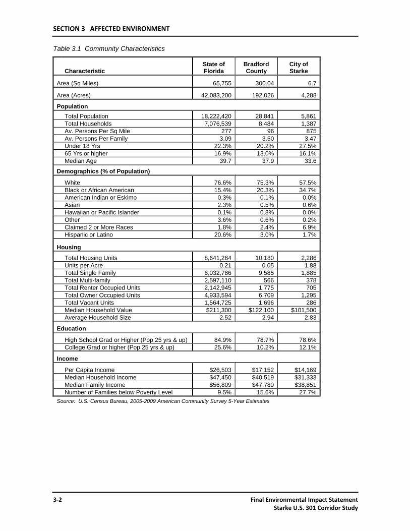
Population data from the U.S. Census Bureau’s 2005-2009 American Community Survey 5-Year Estimates is accumulated to provide a general picture of the community characteristics in the immediate project area and to allow comparison among the proposed alternatives. A comparison of the characteristics of Florida, Bradford County and the City of Starke is important in assessing possible socio-economic impacts of the project. The data for these census areas is shown on Table 3.1.
The census data indicates that the median age in Bradford County and the City of Starke is lower than the statewide median age. The percentage of persons 65 and older is higher statewide than in the study area. This data is consistent with the data that indicates that average number of persons per family and average household size is larger than the statewide averages. While there are many retirement communities throughout Florida, there are no such large retirement communities in Bradford County or the City of Starke.
The percentage of vacant housing units within the city and the county ranges from 12-16%, respectively, which is lower than the statewide average of 18% vacant units. The percentage of renter occupied units is lower in the county than statewide, but higher in the city than the statewide average. The median household value is lower in the area than the statewide average.
In Bradford County and the City of Starke, there is a higher percentage of minorities than there is statewide. The per capita income, median household income and median family income is lower in both the city and county than statewide. And there are a much higher percentage of families below the poverty level than statewide. The percentage of high school graduates and college graduates is lower in the area than statewide.
Development activity in Bradford County was slow but steady between 1995 and 2005, with a total of 572 housing starts. Development began to slow in 2006. However, the population, employment and income have continued to increase.
SECTION 3 AFFECTED ENVIRONMENT
3-2 Final Environmental Impact Statement Starke U.S. 301 Corridor Study
Table 3.1 Community Characteristics
Characteristic State of Florida
Bradford County
City of Starke
Area (Sq Miles) 65,755 300.04 6.7
Area (Acres) 42,083,200 192,026 4,288
Population
Total Population 18,222,420 28,841 5,861
Total Households 7,076,539 8,484 1,387
Av. Persons Per Sq Mile 277 96 875
Av. Persons Per Family 3.09 3.50 3.47
Under 18 Yrs 22.3% 20.2% 27.5%
65 Yrs or higher 16.9% 13.0% 16.1%
Median Age 39.7 37.9 33.6
Demographics (% of Population)
White 76.6% 75.3% 57.5%
Black or African American 15.4% 20.3% 34.7%
American Indian or Eskimo 0.3% 0.1% 0.0%
Asian 2.3% 0.5% 0.6%
Hawaiian or Pacific Islander 0.1% 0.8% 0.0%
Other 3.6% 0.6% 0.2%
Claimed 2 or More Races 1.8% 2.4% 6.9%
Hispanic or Latino 20.6% 3.0% 1.7%
Housing
Total Housing Units 8,641,264 10,180 2,286
Units per Acre 0.21 0.05 1.88
Total Single Family 6,032,786 9,585 1,885
Total Multi-family 2,597,110 566 378
Total Renter Occupied Units 2,142,945 1,775 705
Total Owner Occupied Units 4,933,594 6,709 1,295
Total Vacant Units 1,564,725 1,696 286
Median Household Value $211,300 $122,100 $101,500
Average Household Size 2.52 2.94 2.83
Education
High School Grad or Higher (Pop 25 yrs & up) 84.9% 78.7% 78.6%
College Grad or higher (Pop 25 yrs & up) 25.6% 10.2% 12.1%
Income
Per Capita Income $26,503 $17,152 $14,169
Median Household Income $47,450 $40,519 $31,333
Median Family Income $56,809 $47,780 $38,851
Number of Families below Poverty Level 9.5% 15.6% 27.7%
Source: U.S. Census Bureau, 2005-2009 American Community Survey 5-Year Estimates
SECTION 3 AFFECTED ENVIRONMENT
Final Environmental Impact Statement 3-3 Starke U.S. 301 Corridor Study
3.1.2 ECONOMIC CONDITIONS
3.1.2.1 Employment and Income Data
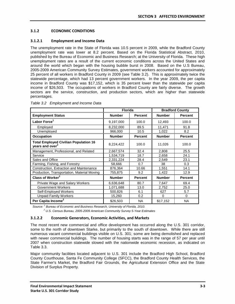
The unemployment rate in the State of Florida was 10.5 percent in 2009, while the Bradford County unemployment rate was lower at 8.2 percent. Based on the Florida Statistical Abstract, 2010, published by the Bureau of Economic and Business Research; at the University of Florida. These high unemployment rates are a result of the current economic conditions across the United States and around the world which began with the housing bubble burst in 2008. Based on the U.S Bureau, 2005-2009 American Community Survey Estimates, government workers accounted for approximately 25 percent of all workers in Bradford County in 2009 (see Table 3.2). This is approximately twice the statewide percentage, which had 13 percent government workers. In the year 2009, the per capita income in Bradford County was $17,152, which is 35 percent lower than the statewide per capita income of $26,503. The occupations of workers in Bradford County are fairly diverse. The growth sectors are the service, construction, and production sectors, which are higher than statewide percentages.
Table 3.2 Employment and Income Data
Florida Bradford County
Employment Status Number Percent Number Percent
Labor Force1 9,197,000 100.0 12,493 100.0
Employed 8,232,000 89.5 11,471 91.8
Unemployed 966,000 10.5 1,022 8.2
Occupation Number Percent Number Percent
Total Employed Civilian Population 16 years and over
2
8,224,422 100.0 11,026 100.0
Management, Professional, and Related 2,667,574 32.4 2,808 25.5
Service 1,534,719 18.7 2,658 24.1
Sales and Office 2,331,224 28.4 2,549 23.1
Farming, Fishing, and Forestry 58,666 0.7 38 0.3
Construction, Extraction and Maintenance 876,364 10.66 1,551 14.1
Production, Transportation, Material Moving 755,875 9.2 1,422 12.9
Class of Worker2 Number Percent Number Percent
Private Wage and Salary Workers 6,636,648 80.7 7,647 69.4
Government Workers 1,071,688 13.0 2,752 25.0
Self-Employed Workers 500,826 6.1 627 5.7
Unpaid Family Workers 15,260 0.2 0 0
Per Capita Income2 $26,503 NA $17,152 NA
Source: 1 Bureau of Economic and Business Research, University of Florida, 2010.
2 U.S. Census Bureau, 2005-2009 American Community Survey 5-Year Estimates
3.1.2.2 Economic Generators, Economic Activities, and Markets
The most recent new commercial and office development has occurred along the U.S. 301 corridor, some to the north of downtown Starke, but primarily to the south of downtown. While there are still numerous vacant commercial buildings visible on U.S. 301; some are being demolished and replaced with newer commercial buildings. The number of housing starts was in the range of 57 per year until 2007 when construction statewide slowed with the nationwide economic recession, as indicated on Table 3.3.
Major community facilities located adjacent to U.S. 301 include the Bradford High School, Bradford County Courthouse, Santa Fe Community College (SFCC), the Bradford County Health Services, the State Farmer's Market, the Bradford Fair Grounds, the Agricultural Extension Office and the State Division of Surplus Property.
SECTION 3 AFFECTED ENVIRONMENT
3-4 Final Environmental Impact Statement Starke U.S. 301 Corridor Study
3.1.2.3 Tax Base and Revenues
Total tax collections and revenues have increased in Bradford County over the years, despite recent decreases in gas tax revenues and property values. The total taxable value of real and personal property in Bradford County was $363 million in 2000 and $699 million in 2009. This is a 92 percent increase in nine years. There have been no residential housing starts in Bradford County since 2007. See Table 3.3 for additional countywide tax and revenue statistics.
Table 3.3 Summary of Economic Characteristics and Trends in Bradford County, 2000-2009
Taxes and Impact Fees $6,628,000 $11,558,000 74.38%
Federal Grants $266,000 $718,000 169.92%
State and other Governments $3,638,000 $6,568,000 80.54%
Charges for Services $2,376,000 $3,193,000 34.39%
Fines and Forfeits $475,000 $612,000 28.84%
Other Sources and Transfers $8,243,000 $13,279,000 61.09%
Real Property and Ad Valorem Taxes
Just Value of Real Property $806,774,000 $1,974,348,000 144.72%
Taxable Values $363,341,000 $698,685,000 92.29%
Residential $345,310,000 $697,190,000 101.90%
Commercial $47,040,000 $97,220,000 106.68%
Industrial $10,640,000 $16,000,000 50.38%
Total Taxes Levied $9,787,000 $15,520,000 58.58%
Residential Construction Starts 57 0 -100.00%
Source: Florida Statistical Abstract 2001, 2010, Bureau of Economic and Business Research (BEBR)
3.1.3 COMPREHENSIVE PLANNING
3.1.3.1 Planning Jurisdictions
The City of Starke and Bradford County provide local land use and growth management goals and objectives for the project area. The Recommended Transportation Improvements map in the City of Starke Comprehensive Plan includes a widening of U.S. 301 to a six-lane facility or an equivalent action (Appendix B, Exhibit B.10). The Future Traffic Circulation Map of the Bradford County Comprehensive Plan 2016 was amended in 2009 to include the proposed bypass (Rural Alternative) (Appendix B, Exhibit B.9).
The State of Florida and the NCFRPC provide state and regional goals, objectives and policies for growth management. The Florida Department of Community Affairs (DCA) and the NCFRPC review comprehensive plan amendments and developments of regional impact applications. Correspondence received from the regional planning agency indicates that the goals of the project are in accordance with the goals and policies of that agency (Appendix A, Exhibit A.5).
SECTION 3 AFFECTED ENVIRONMENT
Final Environmental Impact Statement 3-5 Starke U.S. 301 Corridor Study
3.1.3.2 Existing and Future Land Use
Bradford County is a somewhat rural county with a density of 96 persons per square mile. This density is in the mid range for counties in the State of Florida. Approximately, 20 percent of the county population lives within the City of Starke. The City of Starke is only 6.7 square miles in size and has a total population of 5,861, or 875 persons per square mile. Figure 3.1 shows the existing land use in the study area.
The City of Starke 2010 Future Land Use Plan (see Figure 3.2) shows that along U.S. 301 both to the north and south of the urban center, commercial uses will fill in where residential and currently undeveloped areas exist. A new industrial area has been designated to the southeast in the vicinity of the CSX main rail line and just north of the industrial area designated by the County. There is a conservation area centered on Alligator Creek within the city limits. This conservation area designates a 50-foot buffer on both sides of the creek. The city’s wastewater spray fields are designated as public reserve.
In Bradford County, the vast majority of new development is expected to occur within a designated Urban Development Area. The currently adopted Bradford County 2016 Future Land Use Plan shows an Urban Development Area that surrounds and includes the City of Starke (see Figure 3.2). This designated area stretches north along U.S. 301 approximately one mile and south on U.S. 301 about one and a half miles. To the west it stretches to Lake Crosby and Lake Rowell and to the east one and a half miles in the vicinity of the Starke Country Club.
Other than the commercial and industrial land uses designated along U.S. 301 south of the city limits, the unincorporated areas within the Urban Development Area are mostly designated primarily for low-density residential uses of two or less dwelling units per acre. There are no unique or prime farmlands in Bradford County. The areas within the project area that are outside the Urban Development Areas are planned for agriculture uses and allow for rural residential development at a density of one dwelling unit for every five acres.
3.2 UTILITIES AND RAILROADS
3.2.1 UTILITIES
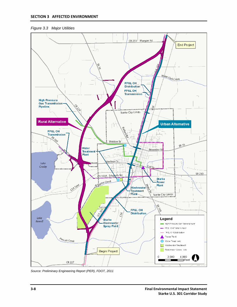
The existing U.S. 301 route through the project area accommodates both overhead and underground utilities. These utilities consist primarily of electric, gas, telephone, cable services, as well as, municipal sewer and water. These services are provided by a variety of companies. The major utilities within the project area are shown on Figure 3.3.
3.2.1.1 Electric Power
Electric power service is provided by three different entities within the project area: Florida Power and Light (FPL), Clay Electric Cooperative, Inc. (CEC), and the City of Starke. These facilities consist of both primary and secondary overhead transmission power lines. FPL provides service by way of 240 KV overhead transmission lines, 13 KV three-phase overhead electric feeders and one-phase overhead electric feeders. At the south project limits is a 13 KV three-phase feeder that parallels U.S. 301 on the west side of the road right-of-way. At C.R. 227, the feeder crosses over U.S. 301 and continues parallel to it on the east side until it meets a 240 KV overhead transmission line and turns east following the 240 KV transmission line around the east city boundary. North on U.S. 301 in the vicinity of the County Courthouse the 240 KV and 13 KV overhead transmission lines that cross U.S. 301 from the east and turn north to run parallel on the west side of U.S. 301. This facility continues north to the project terminus.
SECTION 3 AFFECTED ENVIRONMENT
3-6 Final Environmental Impact Statement Starke U.S. 301 Corridor Study
Figure 3.1 Existing Land Use
Source: Bradford County Property Appraiser, Parcel Data
SECTION 3 AFFECTED ENVIRONMENT
Final Environmental Impact Statement 3-7 Starke U.S. 301 Corridor Study
Figure 3.2 Future Land Use and Urban Development Area
Source: City of Starke Comprehensive Plan, Future Land Use Map; and Bradford County Comprehensive Plan, Future Land Use Map.
SECTION 3 AFFECTED ENVIRONMENT
3-8 Final Environmental Impact Statement Starke U.S. 301 Corridor Study
Final Environmental Impact Statement 3-9 Starke U.S. 301 Corridor Study
Clay Electric Cooperative, Inc. also provides electric power service within the project area. One of their major facilities is a 69 KV overhead transmission line that intersects U.S. 301 in the vicinity of the south project limits. Beginning just north of that point there is a feeder that crosses U.S. 301 from the west and runs parallel to U.S. 301 until the C.R. 227 intersection where the feeder splits. One line crosses back across U.S. 301 and continues west along C.R. 227, and the other, a 7.6 KV line, continues north along U.S. 301 on the east side. The 7.6 KV line intersects a 66 KV overhead transmission line at the intersection of Edwards Road (C.R. 100A). Only one other CEC feeder intersects with U.S. 301 near the north city limits. The City of Starke provides electrical services within the Starke city limits.
3.2.1.2 Gas
The Florida Gas Transmission Company and the City of Starke provide gas services within the project area. The Florida Gas Transmission Company has an underground high pressure gas facility intersecting U.S. 301 in the downtown area. The facility is a 3.5-inch steel, high-pressure natural gas transmission line intersecting U.S. 301 along Pratt Street. The City of Starke also has underground gas facilities located within the project area.
3.2.1.3 Telephone and Cable
The telephone facilities through the project area are owned and operated by the Central Telephone Company of Florida (CENTEL). The Sprint Corporation provides long distance telephone services. Fiber optic lines follow the CSX main rail line. Clay Cablevision provides cable television services.
3.2.1.4 Potable Water
The City of Starke owns and operates the only central water supply and distribution system within the corporate limits that serves approximately 60 percent of the City. The City has two wells that tap the Floridan aquifer and provide water to two water treatment plants which are located to the west of U.S. 301 along C.R. 100A and C.R. 229. The distribution system has recently undergone replacement of its aged distribution lines. There are water distribution lines along most of U.S. 301 within the city limits. While there are four separate private-community potable water systems serving limited areas, Bradford County does not operate a potable water system in the unincorporated areas.
3.2.1.5 Sanitary Sewer
The City of Starke maintains a Wastewater Treatment Facility to the west of U.S. 301 on C.R. 100A (Edwards Road). The treated wastewater is discharged to Alligator Creek. The City system serves approximate 60 percent of the Starke incorporated area, only. Wastewater collection system lines run along most sections of U.S. 301 within the city limits. This system is near capacity and is currently being expanded to include a spray irrigation field. The spray irrigation field is in a previously undeveloped area near the south city limits just west of U.S. 301. Some of the collection lines will also be replaced over the next five years. Bradford County does not own or operate sanitary sewer, or public drainage facilities, and does not plan to construct such facilities within the next twenty years. The unincorporated areas of the county use septic systems to treat and dispose of sewage.
3.2.2 RAILROADS
CSX Transportation owns and operates a mainline facility located parallel to U.S. 301 on the east side through the project area. The facility is spaced as close as 400 feet and as far as one mile east of U.S. 301. The CSX line runs from the eastern seaboard port of Jacksonville through the center of the Florida south to other eastern seaboard ports including: West Palm Beach, Ft. Lauderdale, and Miami. These Metropolitan areas all have major international airport and shipping facilities. While multimodal connections to the Gulf Coast would more logically occur in the Ocala area, multimodal service opportunities exist between Starke and the eastern seaboard cities. Amtrak rail passenger service is provided on the CSX railroad facility. The nearest Amtrak station is located approximately 12 miles south of Starke on S.R. 24 in Waldo. There is one spur that originates from the mainline and intersects U.S. 301 at grade just north of Alligator Creek. This spur crossing has an average of three operations per day providing coal for Gainesville and Florida Power and Light, and was last rubberized in 2011.
SECTION 3 AFFECTED ENVIRONMENT
3-10 Final Environmental Impact Statement Starke U.S. 301 Corridor Study
3.3 CULTURAL RESOURCES
3.3.1 CULTURAL RESOURCE ASSESSMENT AND COORDINATION
A Cultural Resource Assessment Survey (CRAS) was conducted in accordance with the procedures contained in 36 CFR Part 800, including background research and a field survey coordinated with the State Historic Preservation Officer (SHPO). The first assessment was preformed for the project in 1997. As a result of the assessment, twelve previously unrecorded archaeological sites (8BF104-114 and 8BF136) and twenty historic properties (8BF115-135) were recorded during the course of the survey. Based on the results of these surveys, three properties, Sites 8BF110 (Mullins’ Pasture, formerly known as the Heady Wine Site), 8BF120 (Old National Guard Armory) and 8BF121 (St. Edward’s Catholic Church), were determined eligible for listing in the NHRP and the remaining properties were determined ineligible. A letter of concurrence dated November 16, 1998 regarding the eligibility determination for these sites was received from the SHPO (Appendix A, Exhibit A.24).
A subsequent survey was done in 2004 to investigate an informant report regarding the former Brymer Cemetery (8BF162), which was purported to be located within the project area. After this subsequent survey the site was determined not eligible for the NRHP. SHPO has concurred with this finding and has requested that, if the Rural Alternative is recommended, a meeting be held to coordinate the appropriate measures to locate any remaining gravesites and that an archaeological monitoring report be submitted. (Appendix A, Exhibit A.26). In addition, a supplemental assessment of the Mullins’ Pasture Site (8BF110) was conducted in 2008 and found that the site is not eligible for the NRHP under "Criterion D," the ability to provide information "important in prehistory and history," as defined in 36 CFR 60.4. A letter from SHPO regarding concurrence with the findings for Site 8BF110 is included in Appendix A, A.29).
An update of the CRAS was conducted in 2010, which included an updated architectural history survey of both the Urban and Rural Alternatives, and additional archaeological testing in areas that were not previously tested because of revisions that were subsequently made to the design of the Rural Alternative. The updated architectural history survey identified, 32 previously recorded structures that remain within the area of potential affect (APE), including two resources that are listed in the NRHP (8BF7, Old Bradford County Courthouse, and 8BF57, the Call Street Historic District) and two resources (BF120, Old National Guard Armory, and BF121, St. Edward’s Catholic Church) that were recommended potentially eligible for the NRHP during the previous survey. In addition, 93 unrecorded historic structures were identified within the area of potential effect (APE) of the proposed Build Alternatives. Based on field review, eight of the unrecorded historic structures appeared to meet the minimum criteria for listing in the NRHP. Four of the eight are motor courts, two are commercial buildings, one is a church, and the other is a portion of the railroad bed for the Atlantic Suwannee River and Gulf (ASR&G) Railroad.
The 2010 updated archaeological survey of previously untested portions of the Rural Alternative resulted in the expansion of one previously recorded prehistoric site (8BF113) and the identification of one new historic-period site (8BF729). Both of these sites were determined to be not eligible for listing on the NRHP. As part of this survey, the limits of the previously recorded Keller Cemetery (8BF135) were also defined through a combination of ground-penetrating radar (GPR) survey, visual examination, and informant interviews.
SHPO concurred with the recommendations of the 2010 CRAS update that the two archaeological sites (8BF113 and 8BF729) near the Rural Alternative are not eligible for listing on the NRHP. SHPO also concurred with the recommendations regarding the four previously recorded historic structures (8BF7, 8BF57, 8BF120, and 8BF121) as potentially eligible for the NRHP. However, due to insufficient information at the time, SHPO was unable to concur on the eligibility of the 93 unrecorded structures, including the eight that were recommended as being potentially eligible for the NRHP. Therefore, if the Urban Alternative is recommended as the preferred alternative for this project, SHPO requested that the 93 historic structures be recorded and SHPO be given the opportunity to comment on their eligibility (Appendix A, Exhibit A.32).
FHWA forwarded the updated CRAS to Miccosukee Tribe of Indians of Florida, Seminole Tribe of Florida, Seminole Nation of Oklahoma, Poach Band of Creek Indians, Muscogee (Creek) Nation, and
SECTION 3 AFFECTED ENVIRONMENT
Final Environmental Impact Statement 3-11 Starke U.S. 301 Corridor Study
Mississippi Band of Choctaw Indians soliciting comments concerning any religious or cultural significance associated with any historic property that may be affected by the project. No objections to the project were received. Correspondence regarding coordination with Native American tribes is included in Appendix A, Exhibits A.33-A.40.
An addendum to the 2010 CRAS was completed in 2011. This survey records and evaluates 28 historic resources identified within the APE for the Rural Alternative. Two of these resources, the Matthews Building (8BF758) and ASR&G Railroad (8BF759) are determined to be eligible for the NRHP. The Rural Alternative will not require right-of-way from these resources and the railroad will be overpassed, therefore it has been determined that there will not be an effect on integrity of these resources. The survey also determined that the two historic cemeteries (8BF135 and 8BD162) are not eligible for NRHP. The SHPO concurs with the survey recommendations and requests that Florida Master Site Files (FMSF) forms documenting individual structures on the Matthews Building (8BF758) property be submitted and that an architectural monitoring report documenting the mechanical scraping and any subsequent excavation at the site of the former Brymer Cemetery (8BF162) which will occur during construction (see Appendix A, Exhibit A.42).
3.3.1.1 Archaeological Sites
A summary of all of the archaeological sites identified within the APE for the proposed project Build Alternatives is provided in Table 3.4. As a result of coordination with FHWA and SHPO, none of the archaeological sites have been determined eligible for the NRHP (see Section 3.3.1). Further information regarding all of the archaeological sites may be found in the two CRAS documents, which are included on the attached DVD and available at the FDOT District Two Office in Lake City, Florida.
Table 3.4 Archaeological Site Data Summary
Site # Site Name Site Type Culture SHPO Evaluation
8BF104 (Unspecified) Prehistoric terrestrial Prehistoric Not Eligible
8BF105 (Unspecified) Prehistoric terrestrial Prehistoric Not Eligible
8BF106 (Unspecified) Prehistoric terrestrial Prehistoric Not Eligible
8BF108 (Unspecified) Prehistoric terrestrial Prehistoric Not Eligible
8BF109 (Unspecified) Prehistoric terrestrial Prehistoric Not Eligible
8BF112 Edwards Loop Prehistoric terrestrial PPoosstt--AArrcchhaaiicc ((cceerraammiicc)) Not Eligible
8BF113 Spray Field Prehistoric terrestrial Prehistoric Not Eligible
8BF114 Canova Prehistoric terrestrial American, 1900 - present Not Eligible
8BF136 Boyette Prehistoric terrestrial Prehistoric Not Eligible
8BF729 U.S. 301 Historic Site 1
Historic artifact scatter American, 1900 - present Not Eligible
Source: Cultural Resource Assessment (CRAS), FDOT, 2010.
SECTION 3 AFFECTED ENVIRONMENT
3-12 Final Environmental Impact Statement Starke U.S. 301 Corridor Study
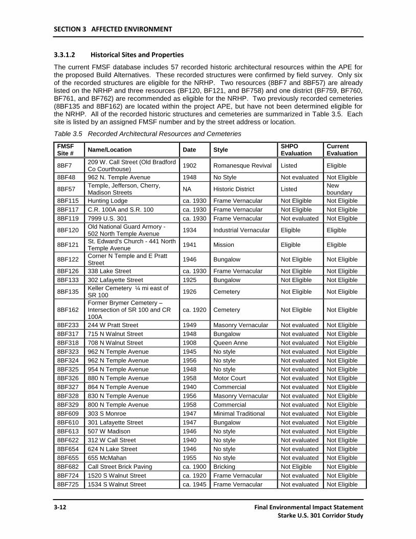
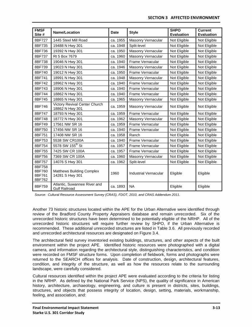
3.3.1.2 Historical Sites and Properties
The current FMSF database includes 57 recorded historic architectural resources within the APE for the proposed Build Alternatives. These recorded structures were confirmed by field survey. Only six of the recorded structures are eligible for the NRHP. Two resources (8BF7 and 8BF57) are already listed on the NRHP and three resources (BF120, BF121, and BF758) and one district (BF759, BF760, BF761, and BF762) are recommended as eligible for the NRHP. Two previously recorded cemeteries (8BF135 and 8BF162) are located within the project APE, but have not been determined eligible for the NRHP. All of the recorded historic structures and cemeteries are summarized in Table 3.5. Each site is listed by an assigned FMSF number and by the street address or location.
Table 3.5 Recorded Architectural Resources and Cemeteries
FMSF Site #
Name/Location Date Style SHPO Evaluation
Current Evaluation
8BF7 209 W. Call Street (Old Bradford Co Courthouse)
1902 Romanesque Revival Listed Eligible
8BF48 962 N. Temple Avenue 1948 No Style Not evaluated Not Eligible
8BF57 Temple, Jefferson, Cherry, Madison Streets
NA Historic District Listed New boundary
8BF115 Hunting Lodge ca. 1930 Frame Vernacular Not Eligible Not Eligible
8BF117 C.R. 100A and S.R. 100 ca. 1930 Frame Vernacular Not Eligible Not Eligible
8BF119 7999 U.S. 301 ca. 1930 Frame Vernacular Not evaluated Not Eligible
8BF120 Old National Guard Armory - 502 North Temple Avenue
1934 Industrial Vernacular Eligible Eligible
8BF121 St. Edward's Church - 441 North Temple Avenue
1941 Mission Eligible Eligible
8BF122 Corner N Temple and E Pratt Street
1946 Bungalow Not Eligible Not Eligible
8BF126 338 Lake Street ca. 1930 Frame Vernacular Not Eligible Not Eligible
8BF133 302 Lafayette Street 1925 Bungalow Not Eligible Not Eligible
8BF135 Keller Cemetery ¼ mi east of SR 100
1926 Cemetery Not Eligible Not Eligible
8BF162 Former Brymer Cemetery – Intersection of SR 100 and CR 100A
ca. 1920 Cemetery Not Eligible Not Eligible
8BF233 244 W Pratt Street 1949 Masonry Vernacular Not evaluated Not Eligible
8BF317 715 N Walnut Street 1948 Bungalow Not evaluated Not Eligible
8BF318 708 N Walnut Street 1908 Queen Anne Not evaluated Not Eligible
8BF323 962 N Temple Avenue 1945 No style Not evaluated Not Eligible
8BF324 962 N Temple Avenue 1956 No style Not evaluated Not Eligible
8BF325 954 N Temple Avenue 1948 No style Not evaluated Not Eligible
8BF326 880 N Temple Avenue 1958 Motor Court Not evaluated Not Eligible
8BF327 864 N Temple Avenue 1940 Commercial Not evaluated Not Eligible
8BF328 830 N Temple Avenue 1956 Masonry Vernacular Not evaluated Not Eligible
8BF329 800 N Temple Avenue 1958 Commercial Not evaluated Not Eligible
8BF609 303 S Monroe 1947 Minimal Traditional Not evaluated Not Eligible
8BF610 301 Lafayette Street 1947 Bungalow Not evaluated Not Eligible
8BF613 507 W Madison 1946 No style Not evaluated Not Eligible
8BF622 312 W Call Street 1940 No style Not evaluated Not Eligible
8BF654 624 N Lake Street 1946 No style Not evaluated Not Eligible
8BF655 655 McMahan 1955 No style Not evaluated Not Eligible
8BF682 Call Street Brick Paving ca. 1900 Bricking Not Eligible Not Eligible
8BF724 1520 S Walnut Street ca. 1920 Frame Vernacular Not evaluated Not Eligible
8BF725 1534 S Walnut Street ca. 1945 Frame Vernacular Not evaluated Not Eligible
SECTION 3 AFFECTED ENVIRONMENT
Final Environmental Impact Statement 3-13 Starke U.S. 301 Corridor Study
FMSF Site #
Name/Location Date Style SHPO Evaluation
Current Evaluation
8BF727 1445 Steel Mill Road ca. 1955 Masonry Vernacular Not Eligible Not Eligible
8BF735 19488 N Hwy 301 ca. 1948 Split-level Not Eligible Not Eligible
8BF736 19392 N Hwy 301 ca. 1950 Masonry Vernacular Not Eligible Not Eligible
8BF737 Rt 5 Box 7679 ca. 1960 Masonry Vernacular Not Eligible Not Eligible
8BF738 19046 N Hwy 301 ca. 1940 Frame Vernacular Not Eligible Not Eligible
8BF739 19023 N Hwy 301 ca. 1946 Masonry Vernacular Not Eligible Not Eligible
8BF740 19012 N Hwy 301 ca. 1950 Frame Vernacular Not Eligible Not Eligible
8BF741 18991 N Hwy 301 ca. 1948 Masonry Vernacular Not Eligible Not Eligible
8BF742 18962 N Hwy 301 ca. 1940 Frame Vernacular Not Eligible Not Eligible
8BF743 18906 N Hwy 301 ca. 1940 Frame Vernacular Not Eligible Not Eligible
8BF744 18862 N Hwy 301 ca. 1940 Frame Vernacular Not Eligible Not Eligible
8BF745 18865 N Hwy 301 ca. 1965 Masonry Vernacular Not Eligible Not Eligible
8BF746 Victory Revival Center Church 18862 N Hwy 301
ca. 1959 Masonry Vernacular Not Eligible Not Eligible
8BF747 18793 N Hwy 301 ca. 1959 Frame Vernacular Not Eligible Not Eligible
8BF748 18772 N Hwy 301 ca. 1962 Masonry Vernacular Not Eligible Not Eligible
8BF749 17561 NW SR 16 ca. 1959 Frame Vernacular Not Eligible Not Eligible
8BF750 17456 NW SR 16 ca. 1940 Frame Vernacular Not Eligible Not Eligible
8BF751 17408 NW SR 16 ca. 1958 Ranch Not Eligible Not Eligible
8BF753 5538 SW CR100A ca. 1940 Frame Vernacular Not Eligible Not Eligible
8BF754 5578 SW 155th
St ca. 1957 Frame Vernacular Not Eligible Not Eligible
8BF755 7425 SW CR 100A ca. 1957 Frame Vernacular Not Eligible Not Eligible
8BF756 7369 SW CR 100A ca. 1960 Masonry Vernacular Not Eligible Not Eligible
8BF757 14076 S Hwy 301 ca. 1962 Split-level Not Eligible Not Eligible
8BF758 8BF760 8BF761 8BF762
Matthews Building Complex 14281 S Hwy 301
1960 Industrial Vernacular Eligible Eligible
8BF759 Atlantic, Suwannee River and Gulf Railroad
ca. 1893 NA Eligible Eligible
Source: Cultural Resource Assessment Survey (CRAS), FDOT, 2010, and CRAS Addendum 2011.
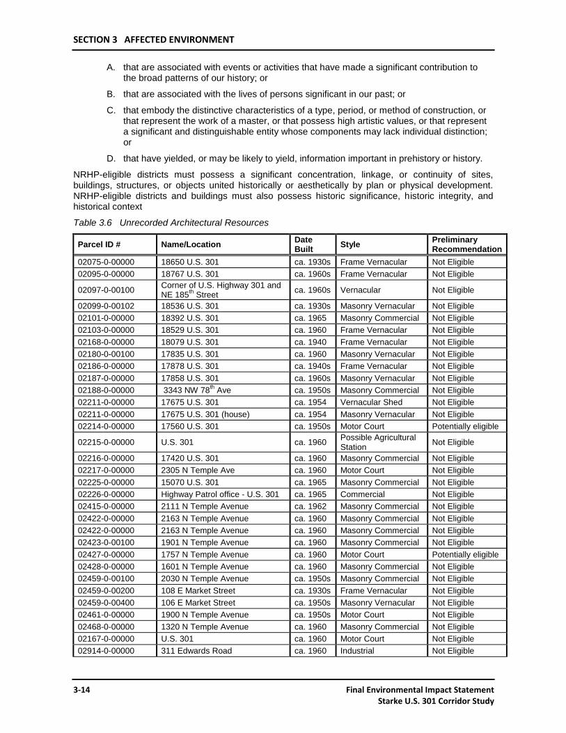
Another 73 historic structures located within the APE for the Urban Alternative were identified through review of the Bradford County Property Appraisers database and remain unrecorded. Six of the unrecorded historic structures have been determined to be potentially eligible of the NRHP. All of the unrecorded historic structures will require further review by SHPO, if the Urban Alternative is recommended. These additional unrecorded structures are listed in Table 3.6. All previously recorded and unrecorded architectural resources are designated on Figure 3.4.
The architectural field survey inventoried existing buildings, structures, and other aspects of the built environment within the project APE. Identified historic resources were photographed with a digital camera, and information regarding the architectural style, distinguishing characteristics, and condition were recorded on FMSF structure forms. Upon completion of fieldwork, forms and photographs were returned to the SEARCH offices for analysis. Date of construction, design, architectural features, condition, and integrity of the structure, as well as how the resources relate to the surrounding landscape, were carefully considered.
Cultural resources identified within the project APE were evaluated according to the criteria for listing in the NRHP. As defined by the National Park Service (NPS), the quality of significance in American history, architecture, archaeology, engineering, and culture is present in districts, sites, buildings, structures, and objects that possess integrity of location, design, setting, materials, workmanship, feeling, and association, and:
SECTION 3 AFFECTED ENVIRONMENT
3-14 Final Environmental Impact Statement Starke U.S. 301 Corridor Study
A. that are associated with events or activities that have made a significant contribution to the broad patterns of our history; or
B. that are associated with the lives of persons significant in our past; or
C. that embody the distinctive characteristics of a type, period, or method of construction, or that represent the work of a master, or that possess high artistic values, or that represent a significant and distinguishable entity whose components may lack individual distinction; or
D. that have yielded, or may be likely to yield, information important in prehistory or history.
NRHP-eligible districts must possess a significant concentration, linkage, or continuity of sites, buildings, structures, or objects united historically or aesthetically by plan or physical development. NRHP-eligible districts and buildings must also possess historic significance, historic integrity, and historical context
Table 3.6 Unrecorded Architectural Resources
Parcel ID # Name/Location Date Built
Style Preliminary Recommendation
02075-0-00000 18650 U.S. 301 ca. 1930s Frame Vernacular Not Eligible
02095-0-00000 18767 U.S. 301 ca. 1960s Frame Vernacular Not Eligible
02097-0-00100 Corner of U.S. Highway 301 and NE 185
th Street
ca. 1960s Vernacular Not Eligible
02099-0-00102 18536 U.S. 301 ca. 1930s Masonry Vernacular Not Eligible
02101-0-00000 18392 U.S. 301 ca. 1965 Masonry Commercial Not Eligible
02103-0-00000 18529 U.S. 301 ca. 1960 Frame Vernacular Not Eligible
02168-0-00000 18079 U.S. 301 ca. 1940 Frame Vernacular Not Eligible
02180-0-00100 17835 U.S. 301 ca. 1960 Masonry Vernacular Not Eligible
02186-0-00000 17878 U.S. 301 ca. 1940s Frame Vernacular Not Eligible
02187-0-00000 17858 U.S. 301 ca. 1960s Masonry Vernacular Not Eligible
02188-0-00000 3343 NW 78th Ave ca. 1950s Masonry Commercial Not Eligible
02211-0-00000 17675 U.S. 301 ca. 1954 Vernacular Shed Not Eligible
02211-0-00000 17675 U.S. 301 (house) ca. 1954 Masonry Vernacular Not Eligible
02214-0-00000 17560 U.S. 301 ca. 1950s Motor Court Potentially eligible
02215-0-00000 U.S. 301 ca. 1960 Possible Agricultural Station
Not Eligible
02216-0-00000 17420 U.S. 301 ca. 1960 Masonry Commercial Not Eligible
02217-0-00000 2305 N Temple Ave ca. 1960 Motor Court Not Eligible
02225-0-00000 15070 U.S. 301 ca. 1965 Masonry Commercial Not Eligible
02226-0-00000 Highway Patrol office - U.S. 301 ca. 1965 Commercial Not Eligible
02415-0-00000 2111 N Temple Avenue ca. 1962 Masonry Commercial Not Eligible
02422-0-00000 2163 N Temple Avenue ca. 1960 Masonry Commercial Not Eligible
02422-0-00000 2163 N Temple Avenue ca. 1960 Masonry Commercial Not Eligible
02423-0-00100 1901 N Temple Avenue ca. 1960 Masonry Commercial Not Eligible
02427-0-00000 1757 N Temple Avenue ca. 1960 Motor Court Potentially eligible
02428-0-00000 1601 N Temple Avenue ca. 1960 Masonry Commercial Not Eligible
02459-0-00100 2030 N Temple Avenue ca. 1950s Masonry Commercial Not Eligible
02459-0-00200 108 E Market Street ca. 1930s Frame Vernacular Not Eligible
02459-0-00400 106 E Market Street ca. 1950s Masonry Vernacular Not Eligible
02461-0-00000 1900 N Temple Avenue ca. 1950s Motor Court Not Eligible
02468-0-00000 1320 N Temple Avenue ca. 1960 Masonry Commercial Not Eligible
02167-0-00000 U.S. 301 ca. 1960 Motor Court Not Eligible
02914-0-00000 311 Edwards Road ca. 1960 Industrial Not Eligible
SECTION 3 AFFECTED ENVIRONMENT
Final Environmental Impact Statement 3-15 Starke U.S. 301 Corridor Study
Parcel ID # Name/Location Date Built
Style Preliminary Recommendation
03045-0-00000 163 W Jefferson Street ca. 1950s Colonial Revival Church
Potentially eligible
03140-0-00000 207 S Walnut Street ca. 1950s Masonry Commercial Not Eligible
03167-0-00000 206 W Madison Street ca. 1950s Masonry Commercial Not Eligible
03183-0-00000 307 Lafayette Street ca. 1940s Frame Vernacular Not Eligible
03234-0-00000 218 N Temple Avenue ca. 1950s Masonry Commercial Not Eligible
03235-0-00000 205 N Temple Avenue ca. 1950s Masonry Commercial Not Eligible
03253-0-00000 250 N Bay Street ca. 1930s Frame Vernacular Not Eligible
03273-0-00000 407 N Temple Avenue ca. 1950s Masonry Commercial Not Eligible
03274-0-00000 425 N Temple Avenue ca. 1960 Motor Court Not Eligible
03281-0-00000 486 N Temple Avenue ca. 1940s Frame Vernacular Not Eligible
03549-0-00000 302 N Temple Avenue ca. 1950s Gas Station Not Eligible
03554-0-00000 402 N Temple Avenue ca. 1940s Masonry Commercial Not Eligible
03570-0-00000 311 N Temple Avenue ca. 1950s Masonry Commercial Not Eligible
03572-0-00000 353 N Temple Avenue ca. 1950s Masonry Commercial Not Eligible
03572-0-00100 341 N Temple Avenue ca. 1950s Masonry Commercial Not Eligible
03572-0-00200 355 N Temple Avenue ca. 1950s Masonry Commercial Not Eligible
03586-0-00200 620 N Temple Avenue ca. 1950s Masonry Commercial Not Eligible
03617-0-00000 155 N Temple Avenue ca. 1940s Frame Vernacular Not Eligible
03623-0-00000 838 N Temple Avenue ca. 1950s Masonry Commercial Not Eligible
03624-0-00000 N Clark Street ca. 1950s Masonry Commercial Potentially eligible
03628-0-00000 744 N Temple Avenue ca. 1960 Motor Court Potentially eligible
03630-0-00000 668 N Temple Avenue ca. 1950s Masonry Commercial Not Eligible
03632-0-00000 215 Washington ca. 1940s Frame Vernacular Not Eligible
03634-0-00000 617 N Temple Avenue ca. 1950s Masonry Commercial Not Eligible
03641-0-00000 706 McMahan ca. 1965 Masonry Vernacular Not Eligible
03642-0-00000 739 N Temple Avenue ca. 1960 Motor Court Potentially eligible
03643-0-00000 705 N Temple Avenue ca. 1965 Masonry Commercial Not Eligible
04226-0-00000 1330 U.S. 301 ca. 1960 Masonry Vernacular Not Eligible
04226-0-00000 1339 U.S. 301 ca. 1960 Ranch Style Not Eligible
04231-0-00000 1211 Bradford Street ca. 1955 Masonry Commercial Not Eligible
04287-0-00000 2326 SE 129th Street ca. 1960 Masonry Commercial Not Eligible
04300-0-00000 1677 Walnut ca. 1961 Vernacular Shed Not Eligible
04300-0-00000 1677 Walnut (house) ca. 1940 Masonry Vernacular Not Eligible
04440-0-00000 1198 Walnut ca. 1930s Masonry Vernacular Not Eligible
04730-A-00100 14353 U.S. 301 ca. 1960 Masonry Commercial Not Eligible
04723-0-00000 No address (house) ca. 1930s Frame Vernacular Not Eligible
04723-0-00000 No address (outbuilding 1) ca. 1940s Frame Vernacular Not Eligible
04723-0-00000 No address (outbuilding 2) ca. 1940s Frame Vernacular Not Eligible
04723-0-00000 No address (outbuilding 3) ca. 1940s Frame Vernacular Not Eligible
04733-0-00000 13620 U.S. 301 ca. 1948 Motor Court Not Eligible
NA Alligator Creek Bridge ca. 1900 Bridge Not Eligible
Source: Cultural Resource Assessment Survey (CRAS), FDOT, 2010, and CRAS Addendum 2011.
SECTION 3 AFFECTED ENVIRONMENT
3-16 Final Environmental Impact Statement Starke U.S. 301 Corridor Study
Figure 3.4 Historic Sites and Cemeteries
Source: Cultural Resource Assessment Survey (CRAS), FDOT, 2010; and CRAS Addendum, 2011.
SECTION 3 AFFECTED ENVIRONMENT
Final Environmental Impact Statement 3-17 Starke U.S. 301 Corridor Study
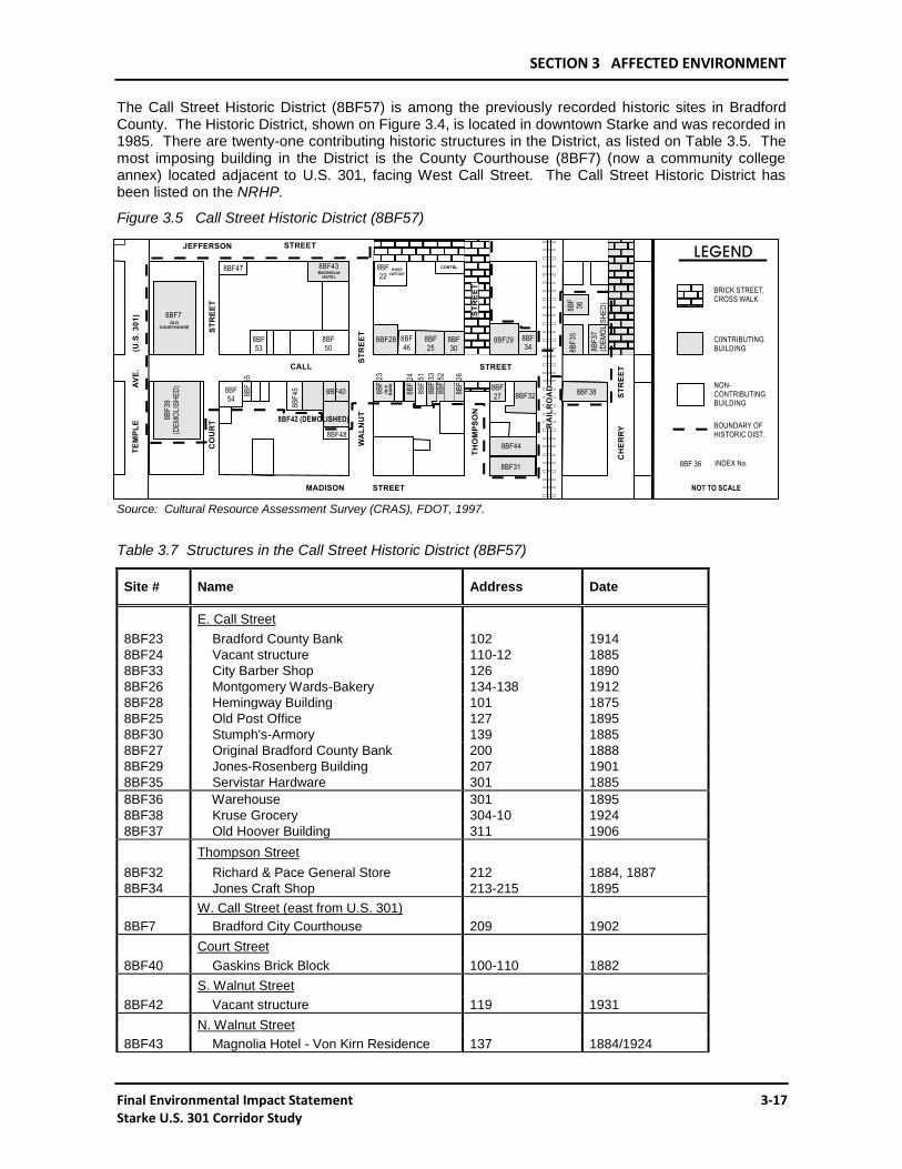
The Call Street Historic District (8BF57) is among the previously recorded historic sites in Bradford County. The Historic District, shown on Figure 3.4, is located in downtown Starke and was recorded in 1985. There are twenty-one contributing historic structures in the District, as listed on Table 3.5. The most imposing building in the District is the County Courthouse (8BF7) (now a community college annex) located adjacent to U.S. 301, facing West Call Street. The Call Street Historic District has been listed on the NRHP.
Figure 3.5 Call Street Historic District (8BF57)
Source: Cultural Resource Assessment Survey (CRAS), FDOT, 1997.
Table 3.7 Structures in the Call Street Historic District (8BF57)
Site # Name Address Date
E. Call Street
8BF23 Bradford County Bank 102 1914
8BF24 Vacant structure 110-12 1885
8BF33 City Barber Shop 126 1890
8BF26 Montgomery Wards-Bakery 134-138 1912
8BF28 Hemingway Building 101 1875
8BF25 Old Post Office 127 1895
8BF30 Stumph's-Armory 139 1885
8BF27 Original Bradford County Bank 200 1888
8BF29 Jones-Rosenberg Building 207 1901
8BF35 Servistar Hardware 301 1885
8BF36 Warehouse 301 1895
8BF38 Kruse Grocery 304-10 1924
8BF37 Old Hoover Building 311 1906
Thompson Street
8BF32 Richard & Pace General Store 212 1884, 1887
8BF34 Jones Craft Shop 213-215 1895
W. Call Street (east from U.S. 301)
8BF7 Bradford City Courthouse 209 1902
Court Street
8BF40 Gaskins Brick Block 100-110 1882
S. Walnut Street
8BF42 Vacant structure 119 1931
N. Walnut Street
8BF43 Magnolia Hotel - Von Kirn Residence 137 1884/1924
SECTION 3 AFFECTED ENVIRONMENT
3-18 Final Environmental Impact Statement Starke U.S. 301 Corridor Study
Site # Name Address Date
S. Thompson Street
8BF44 Vaughn-Johnson Company 122 1924
8BF31 Coca-Cola Bottling Company Plant
Complex 140 1931
Source: Cultural Resource Assessment Survey (CRAS), FDOT, 1997
3.3.2 PARKS AND RECREATION RESOURCES
There are nine park areas designated within the study area, including: Pratt Street Recreation Complex, Edwards Road Recreation Complex, Wainwright Park, Saratoga Heights Park, West Side Park, Jenkins Recreation Center, RJE School Recreation Center, Green Acres Park and Parkwood Park. Only the Greens Acres Park and Parkwood Park are inactive parkland. The Edwards Road Recreation Complex approximately 0.5 mi to the east of existing U.S. 301 has recently been expand-ed. There are no local public parks or recreation areas located in the surrounding unincorporated areas of Bradford County. In addition local parks, public schools provide facilities for active recreation. There are six public schools within the study area. The Bradford High School is located on U.S. 301 within the city of Starke. To the west of the high school are Starke Elementary School, Bradford Middle School, and Bradford-Union Vocational Technical School. Southside Elementary is located southeast of downtown. There are two conservation areas within proximity to the proposed project. The Edwards Bottomland along Alligator Creek is owned and managed by the City of Starke; and the Graham Conservation Area located south of Alligator Creek west of the proposed Rural Alternative is owned and managed by the SRWMD. The Florida Trail is located south of C.R. 227 outside of the project area. A nature trail is currently being considered that would follow Alligator Creek from the Edwards Road Recreation Complex to Lake Rowell west of Starke. No additional facilities are currently planned in either the county or the city.
3.3.3 SECTION 4(f) PROPERTIES
Properties that fall under the protection of Section 4(f) of the U.S. Department of Transportation (USDOT) Act of 1966 [Title 49, USC, Section 1653(f)], as amended by the Federal Highway Act of 1968, include public parks, recreation areas, wildlife and waterfowl refuges, and significant historic and archaeological resources. Section 4(f) properties within the project area include historic resources that are listed on the NHRP, historic resources that are potentially eligible for listing on the NRHP, and a number of parks and recreation areas located throughout the City of Starke. The significant historic resources within the project area are described in detail in Section 3.3.1.2, Historical Sites and Properties, and are shown on Figure 3.5. No significant archaeological resources have been found within the APE. The public parks and recreation areas within the study area are discussed in Section 3.3.2, Parks and Recreation Facilities and are shown on Figure 3.6. There are no designated wildlife management areas within proximity to the proposed project.
SECTION 3 AFFECTED ENVIRONMENT
Final Environmental Impact Statement 3-19 Starke U.S. 301 Corridor Study
Figure 3.6 Parks, Recreation, and Other Community Facilities
Source: Bradford County Property Appraisers, Parcel Data; and Florida Geographic Data Library (FGDL).
SECTION 3 AFFECTED ENVIRONMENT
3-20 Final Environmental Impact Statement Starke U.S. 301 Corridor Study
3.4 NATURAL AND PHYSICAL ENVIRONMENT
3.4.1 PEDESTRIAN AND BICYCLE FACILITIES
There are sidewalks along both sides of U.S. 301 within the city limits; however, there are no bicycle facilities on U.S. 301. There are no provisions in the City of Starke Comprehensive Plan for any future implementation of such facilities on U.S. 301. The Recreation and Open Space Element of the Bradford County Comprehensive Plan does establish a level of service goal for bicycle facilities on local roadways, which will require an approximate total of 26 miles of bicycle facilities in the year 2015.
3.4.2 GROUND WATER
Most of the water consumed in Bradford County is drawn from ground water aquifers. In order of increasing depth, the main aquifer systems under Bradford County are the surficial aquifer system, the intermediate aquifer system, and the Floridan aquifer system. The sediments making up the surficial aquifer system are mainly the sands and thin limestone layers in the Hawthorn Group. Slowly permeable clays above the sand and limestone layers generally confine the intermediate aquifer system under artesian conditions and separate it from the overlying surficial aquifer system. The Floridan Aquifer system is made up of several hundred feet of Eocene- to Oligocene-age porous marine limestones, including the Avon Park Formation and Ocala Group, and Suwannee Limestone. This system is confined by slowly permeable clays of the overlying Hawthorn Group and is under artesian conditions.
3.4.3 SURFACE WATER
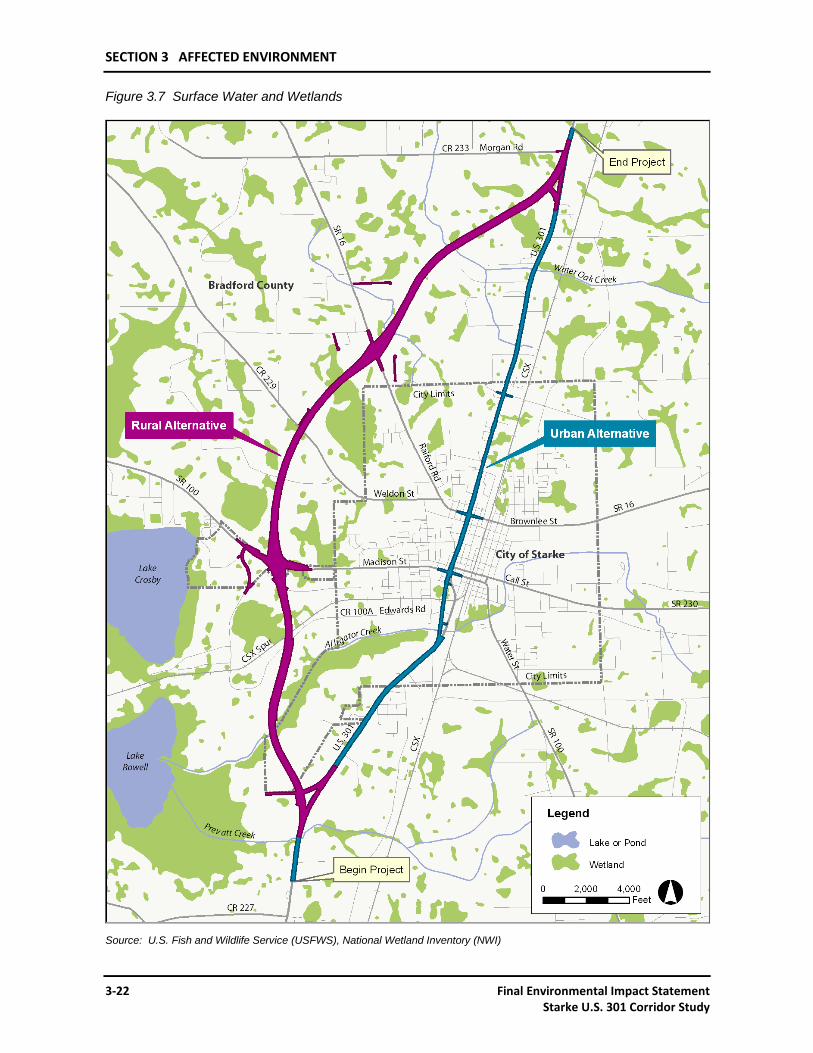
All of the surface water and wetlands in the project area are freshwater and nontidal, including: lacustrine, palustrine and riverine systems. These are currently designated Class III waters, which mean they are suitable for recreation, fish and wildlife support. The lacustrine system includes the open water areas that are comprised of permanently flooded nontidal ponds and lakes, including borrow pits. As shown on Figure 3.7, the most prominent open water sites are to the west of Starke and they include: Lake Crosby and Lake Rowell. There are three creeks that flow across the project area, including Prevatt Creek, Alligator Creek and Water Oak Creek. Large borrow pits occur to the east of Starke near the Bradford and Clay County boundaries. The palustrine system includes: ponds and open water; wet prairies, savannahs; shallow marshes; deep marshes; other emergent wetlands; scrub/shrub wetlands and forested wetlands. There are no navigable waters within the project area. The project is located in the Santa Fe River Basin.
3.4.4 FRESHWATER WETLANDS
Wetlands are widely distributed throughout the project area as indicated on Figure 3.7. These wetland systems have been identified using the USFWS National Wetlands Inventory (NWI). Wetlands identified by the NWI mapping are widely distributed throughout the study area, but they are particularly clustered in two broad belts paralleling the western and eastern project boundaries. The first and largest group occurs west of the existing U.S. 301 roadway around Lakes Crosby and Rowell. Excluding the lakes themselves, the wetlands are primarily forested and emergent types, and they extend from north to south along the entire western portion of the project area. The wetlands that are associated with Alligator Creek extend almost into the town of Starke. The second area occurs along the eastern boundary of the project (the Bradford/Clay county line); these wetlands include tracts of forested communities as well as areas of open water and emergent growth in the large group of excavated ponds south of CR 230.
Even though wetlands are abundant throughout the project area, those sites around the City of Starke and directly north and south of the city are smaller and more isolated than are those along the edges of the project. The size and vegetation makeup of the wetlands are more precisely determined by field analysis. An analysis of the types and functions of wetland is included in Section 4.4.5.3, Wetland Functional Analysis, and in the Wetland Evaluation Report (WER) which is included on the attached DVD, and available at the FDOT District Two Office in Lake City, Florida. The soils analysis for the
SECTION 3 AFFECTED ENVIRONMENT
Final Environmental Impact Statement 3-21 Starke U.S. 301 Corridor Study
project area indicates that soils underlying that portion of Bradford County are predominantly hydric, so additional land not identified, as NWI wetlands may be considered jurisdictional for the purposes of permitting road-building activities.
Wetlands in the Urban Alternative consist of channelized creeks and streams, ditches with floating, rooted and emergent vegetation, isolated herbaceous wetlands, and mixed hardwood and pine forested wetlands. Most of these wetland communities have been impacted by urban development over a long period of time. Wetlands in the Rural Alternative consist of a mixture of hardwood and pine forested wetlands, including cypress/gum swamps, pine wetlands, pine/bay head wetlands, stream floodplain wetlands, and open water/emergent marshes. Much of the original forested habitat has been impacted by agricultural and forestry operations, with large areas occurring presently as pine plantation.
3.4.5 FLOODPLAINS AND REGULATORY FLOODWAYS
There are no regulatory floodways within the project area. The limits of the flood prone areas have been delineated by the Federal Emergency Management Agency (FEMA) as found on Flood Insurance Rate Maps (FIRM) Panels for Bradford County, Florida dated November 15, 1989. Figure 3.8 illustrates the relationship of the project alternatives with the flood hazard areas. Most of the impact areas are transverse encroachments within flood Zone A.
While the flood prone areas are scattered over the entire study area, the largest and most susceptible to flooding are the large wetland systems which surround Lake Rowell and Lake Crosby to the west of the Rural Alternative. A lake restoration project in the Keystone Heights area to the east of Starke has diverted water previously flowing into Alligator Creek, thereby reducing the frequent flooding of the Alligator Creek and Lake Rowell floodplains.
3.4.6 UPLANDS
The project area is located within the Okefenokee Upland portion of the Sea Island Physiographic District of Florida. More specifically, the project area lies within the Flatwoods subdistrict, a poorly dissected upland plain (Brooks 1981). Surface drainage is sluggish, and most of the area consists of poorly drained flatwoods and swamps. Upland sand ridges, that represent relic beach dunes occurring throughout Bradford County, are apparent adjacent to lakes Rowell and Crosby west of the Rural Alternative.
The ecological communities found within the study area reflect the topography and drainage capacities of the soils on which they occur. Under natural conditions, the poorly drained soils tend to support a homogeneous pine-saw palmetto ecosystem, while well to excessively drained upland soils tend to support xeric vegetative communities, most notably turkey oak, live oak, and longleaf pine. Somewhat poorly to moderately well drained soils typically support mesic communities of pine and mixed hardwoods. Presently woodlands, pastureland, thickets, and roadside development occur along the road corridors. In downtown Starke, the Urban Alternative is lined with tightly spaced buildings.
The four most dominant upland communities identified during field survey are described below. The number in parentheses after the community name defines the Florida Land Use, Cover and Forms Classification Code System (FLUCCS) identification of the habitat type (FDOT 1999).
SECTION 3 AFFECTED ENVIRONMENT
3-22 Final Environmental Impact Statement Starke U.S. 301 Corridor Study
Figure 3.7 Surface Water and Wetlands
Source: U.S. Fish and Wildlife Service (USFWS), National Wetland Inventory (NWI)
SECTION 3 AFFECTED ENVIRONMENT
Final Environmental Impact Statement 3-23 Starke U.S. 301 Corridor Study
Figure 3.8 100-Year Floodplain Areas
Source: Federal Emergency Management Agency (FEMA) Flood Insurance Rate Maps (FIRM) Panels for Bradford County, Florida dated November 15, 1989
SECTION 3 AFFECTED ENVIRONMENT
3-24 Final Environmental Impact Statement Starke U.S. 301 Corridor Study
1) Cropland and Pastureland (210) – The Cropland and Pastureland community is characterized by either row crops or general use farming activity. Open areas dominated by various species of pasture grasses characterize the pastureland community.
2) Shrub Brushland (320) – The Shrub Brushland community was at one time a part of a different community such as pine flatwoods or pine plantation; the original vegetation at some time was timbered. The species associated with this community include saw palmetto (Serenoa repens), staggerbush (Lyonia ferruginea), bitter gallberry (Ilex glabra), wax myrtle (Myrica cerifiera), bracken fern (Pteridium aquilinum), blackberry (Rubus spp.), and wiregrass (Aristida stricta).
3) Pine Flatwoods (411) – The Pine Flatwoods community occurs throughout the areas associated with the proposed Rural Alternative. The vegetative species dominating this community include slash pine (Pinus elliottii), longleaf pine (Pinus palustris), saw palmetto (Serenoa repens), and bitter gallberry (Ilex glabra).
4) Pine Flatwoods/Pine Plantation (441) – The Pine Flatwoods/Pine Plantation community occurs throughout the proposed Rural Alternative area. The dominant plant species include slash pine, bitter gallberry, saw palmetto, high-bush blueberry (Vaccinium corymbosum), and bracken fern. Other species include blackberry and longleaf pine.
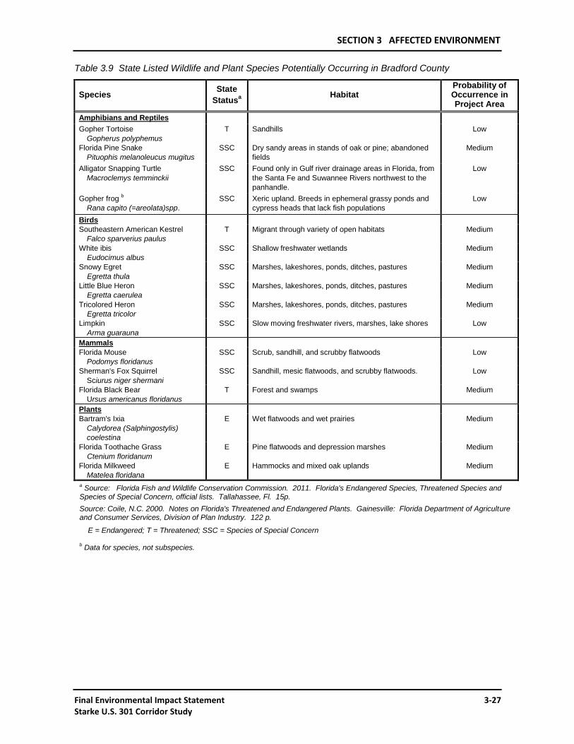
3.4.7 THREATENED AND ENDANGERED SPECIES
In accordance with Section 7(c) of the Endangered Species Act of 1973, the USFWS was contacted early in the project study to obtain a list of endangered and threatened species that may be present in the area. Additionally the Florida Fish and Wildlife Conservation Commission (FWC) (formerly, Florida Game and Fresh Water Fish Commission) and the Florida Natural Areas Inventory (FNAI) were also contacted for information regarding known and potential for occurrence of listed species in the project area. Correspondence with these agencies, as included in Appendix A, indicated that five animals listed by USFWS as federally endangered or threatened, could potentially occur in the project area; these species are listed in Table 3.8. No federally listed species of plants potentially occur in the project area. The project was also screened through the Environmental Transportation Decision-Making (ETDM) process.
A field survey was completed of the project area to confirm potential habitat and to report any of the listed species observed in the area. No federally listed species were observed within the study area during project fieldwork. All information presented is updated as of 2011 to reflect current status of Federal and State listed species and additional field work completed in 2010.
The oval pigtoe mussel (Pleurobema pyriforme), a unionid bivalve mollusk occurring in flowing freshwater streams, once was widely distributed in the Apalachicolan Region (Butler 1993). It occurs in Bradford County, but it has not been recorded in the streams flowing through the project area. Recent survey work done by USFWS (Butler 1993) and by Mason, et al. (1994) examined waters in Bradford County. Butler found one occurrence of the oval pigtoe in New River at C.R. 18, northwest of Brooker and outside the U.S. 301 project area. The study reported by Mason examined the Suwannee River system, including sampling sites on Alligator Creek and in Lake Crosby and Lake Rowell. While they were not sampling especially for mollusks, the oval pigtoe was not among the bivalve species found.
The flatwoods salamander (Ambystoma cingulatum) occurs in open, moist longleaf/slash pine forests that have well developed grass ground cover, typically wiregrass. They require shallow temporary ponds for breeding areas that are isolated wetlands characterized by fringes of cypress (Taxodium spp.), blackgum (Nyssa sylvatica var. biflora) or slash pine (Pinus elliottii) growth. The project area falls within the range of the species, and specimens have been found in Bradford County near Raiford, northwest of the project area (Palis 1995). However, the only known extant Florida population occurring east of the Suwannee River is in Osceola National Forest in counties northwest of the project area (Palis 1996).
SECTION 3 AFFECTED ENVIRONMENT
Final Environmental Impact Statement 3-25 Starke U.S. 301 Corridor Study
Table 3.8 Federally Listed Wildlife and Plant Species Potentially Occurring in Bradford County
Species FederalStatusa Habitat
Probability of Occurrence in Project
Area
Mollusks Oval Pigtoe Mussel
Pleurobema pyriforme E Flowing freshwater streams Low
Amphibians and Reptiles Flatwoods Salamander
Ambystoma cingulatum T
Pine flatwoods with temporary seasonal breeding ponds
Low
Eastern Indigo Snake Drymarchon corais couperi
T Usually xeric; seasonal association with mesic habitat
Medium
Birds Bald Eagle
Haliaeetus leucocephalus Delisted in 2007
Open water and cypress forest
Medium
Wood Stork Mycteria americana
E Marshes, ponds, and cypress swamps
Medium
Red-cockaded Woodpecker Picoides borealis
E Mature longleaf pine forests Low
Mammals None Plants None aSource: U.S. Fish and Wildlife Service. 2010, 50 CFR IB Part 17.11. Endangered and threatened wildlife and plants.
E = Endangered; T = Threatened
The eastern indigo snake (Drymarchon corais couperi) normally is associated with well-drained longleaf pine-xeric oak sandhill habitat, which does not occur in the project area. The indigo snake, however, occupies a large home range and could occupy portions of the mesic forested habitat types during warmer parts of the year.
The bald eagle (Haliaeetus leucocephalus) is known to nest in Bradford County, with one nesting site recorded by USFWS southwest of the Rural Alternative. No bald eagle nests are recorded for the project area (USFWS database, 2010). Because large bodies of water occur nearby, the eagles are likely to overfly portions of the project area, particularly the Rural Alternative, and they could make incidental use of the available forested or emergent habitat. Although the bald eagle has been delisted as a federally threatened species, protection will continue under the Bald and Golden Eagle Protection Act (BGEPA), the Migratory Bird Treaty Act (MBTA), as well as state law by the FWC.
The wood stork (Mycteria americana) is known to occur in Bradford County. The birds feed in widely varying sites, ranging from golf courses to cypress swamps and salt marshes, so they could make incidental use of habitat in the project area. However, no wood storks are reported nesting in the corridor (USFWS database, 2010), nor is the project within a Core Foraging Area (CFA).
The red-cockaded woodpecker (Picoides borealis) is known to occur in Bradford County, but none were observed during field surveys of the project area. The range of this species coincides with the ranges of several species of southern pines, including longleaf pine (Pinus palustris). Its nesting occurs almost completely in mature to over-mature longleaf pine, and this habitat does not occur in the project area.
3.4.8 OTHER WILDLIFE AND HABITAT
The project area was evaluated in relation to wildlife and habitat for indigenous species, both commonly occurring animals and State of Florida listed endangered and threatened species, and species of special concern. The wildlife study began with review of standard reference materials, including Bradford County soil survey maps and tables; U.S. Geological Survey (USGS) 7.5-minute topographic maps and the corresponding USFWS NWI maps for the Sampson and Starke, FL, quadrangles; and FWC mapping of Biodiversity Hot Spots, Priority Wetlands for Listed Species, Strategic Habitat Conservation Areas, and Landsat Land Cover types; preliminary FLUCCS mapping from FDOT; and the Bradford County Comprehensive Plan. Besides these references, a literature
SECTION 3 AFFECTED ENVIRONMENT
3-26 Final Environmental Impact Statement Starke U.S. 301 Corridor Study
search and aerial photo-interpretation were conducted to gather records on regional wildlife and habitats. The FLUCCS mapping was updated, the Advance Notification (AN) package responses received by FDOT were reviewed, and various government agencies were contacted.
Fieldwork was conducted in 1994, 1995, 1996 and 2010 to categorize and evaluate the habitat types within the project area and to record the types of flora and fauna in the vicinity. All modifications to published data were recorded on aerial photographs and maps. All roadkills were noted. Final field work was done in April 2010. The overall project area is primarily pine flatwoods with large portions of the land converted to pine plantations; monotypic stands of pines are expected to harbor fewer resident animal species because of the lack of vegetative diversity. No defined areas of regional biological significance occur. The soil types correspond to the pine flatwoods expanses and do not rank high in providing wildlife habitat. Wildlife use of the wetland communities in the project area is discussed above under Wetlands; the wildlife descriptions given in this section are more generally applicable to uplands as well as wetlands.
The Urban Alternative comprises habitat that is largely dominated by man-made influences, and the wildlife present are the species typical of such situations. Small mammals include the gray squirrel (Sciurus carolinensis), opossum (Didelphis virginiana), armadillo (Dasypus novemcinctus), and raccoon (Procyon lotor). Rodents such as normal urban pest species occur, along with small native species that are found in the more natural areas at the southern and northern ends of the Urban Alternative; these include the house mouse (Mus musculus), cotton rat (Sigmodon hispidus), and shrews (Sorex spp.). Common urban bird species occur, including cardinal (Cardinalis cardinalis), blue jay (Cyanocitta cristata), eastern mockingbird (Mimus polyglottos), red-bellied woodpecker (Melanerpes carolinus), hairy woodpecker (Picoides villosus), flicker (Colaptes auratus), and European starling (Sturnus vulgaris); the cattle egret (Bubulcus ibis) occurs along highways and in other open areas, along with turkey vultures (Cathartes aura) and black vultures (Coragyps atratus). Local bird populations would be expected to increase during spring and fall migration. A complement of small amphibians and reptiles, including bullfrog (Rana catesbeiana), southern leopard frog (Rana utricularia), green tree frog (Hyla cineria), squirrel tree frog (Hyla squirella), green anole (Anolis carolinensis), and black racer (Coluber constrictor) occur along the Urban Alternative.
The Rural Alternative comprises a relatively undeveloped area of pine flatwoods, pine plantations, agricultural land, shrub brushland, and various wetland forested communities. Some residences and other man-dominated areas also occur. Wildlife includes the same species found in the Urban Alternative as well as larger woodland animals; representative species are the bobcat (Lynx rufus), eastern cottontail (Sylvilagus floridanus), white-tailed deer (Odocoileus virginianus), and gray fox (Urocyon cinereoargenteus); raptor species include the red-tailed hawk (Buteo jamaicensis) and red-shouldered hawk (Buteo lineatus). Other more common woodland and woodlot species of the area include the eastern gray squirrel (Sciurus carolinensis), southern flying squirrel (Glaucomys volans), pileated woodpecker (Dryocopus pileatus), pine warbler (Dendroica pinus), and brown-headed nuthatch (Sitta pusilla). Game birds, including the wild turkey (Meleagris gallopavo) and wood duck (Aix sponsa) also occur. Limited habitat for wading birds is found in the Rural Alternative; the cattle egret and vultures discussed above would be expected to occur.
The Florida black bear (Ursus americanus floridanus) occurs in fragmented populations throughout Florida, and its range extends into Bradford County. Individuals from the area occur in or travel through the project area in narrow corridors of occupation that cross U.S. 301. Roadkills of bears indicate their occurrence in the general region; no roadkills have been documented by FWC in the project area. A resident population may be developing in the southern portion of the county; the greatest probability of having a resident group would be in the vicinity of the complex of lakes west and south of Starke (Lakes Sampson, Rowell, Crosby, and Hampton). More of the county may be occupied than FWC previously thought (Personal communication, November 1993, John B. Wooding, FWC Research Laboratory, Gainesville, FL). Pine flatwoods habitat, abundant in the project area, is used by black bears, as are the other forested wetland habitats.
The State of Florida has listed several species as Endangered, Threatened, or as Species of Special Concern that potentially occur in Bradford County. These species are shown on Table 3.9.
SECTION 3 AFFECTED ENVIRONMENT
Final Environmental Impact Statement 3-27 Starke U.S. 301 Corridor Study
Table 3.9 State Listed Wildlife and Plant Species Potentially Occurring in Bradford County
Species State
Statusa Habitat
Probability of Occurrence in Project Area
Amphibians and Reptiles
Gopher Tortoise
Gopherus polyphemus
T Sandhills Low
Florida Pine Snake
Pituophis melanoleucus mugitus
SSC Dry sandy areas in stands of oak or pine; abandoned
fields
Medium
Alligator Snapping Turtle
Macroclemys temminckii
SSC Found only in Gulf river drainage areas in Florida, from
the Santa Fe and Suwannee Rivers northwest to the
panhandle.
Low
Gopher frog b
Rana capito (=areolata)spp.
SSC Xeric upland. Breeds in ephemeral grassy ponds and
cypress heads that lack fish populations
Low
Birds
Southeastern American Kestrel
Falco sparverius paulus
T Migrant through variety of open habitats Medium
White ibis
Eudocimus albus
SSC Shallow freshwater wetlands Medium
Snowy Egret
Egretta thula
SSC Marshes, lakeshores, ponds, ditches, pastures Medium
Little Blue Heron
Egretta caerulea
SSC Marshes, lakeshores, ponds, ditches, pastures Medium
Tricolored Heron
Egretta tricolor
SSC Marshes, lakeshores, ponds, ditches, pastures Medium
Limpkin
Arma guarauna
SSC Slow moving freshwater rivers, marshes, lake shores Low
Mammals
Florida Mouse
Podomys floridanus
SSC Scrub, sandhill, and scrubby flatwoods Low
Sherman's Fox Squirrel
Sciurus niger shermani
SSC Sandhill, mesic flatwoods, and scrubby flatwoods. Low
Florida Black Bear
Ursus americanus floridanus
T Forest and swamps Medium
Plants
Bartram's Ixia
Calydorea (Salphingostylis)
coelestina
E Wet flatwoods and wet prairies Medium
Florida Toothache Grass
Ctenium floridanum
E Pine flatwoods and depression marshes Medium
Florida Milkweed
Matelea floridana
E Hammocks and mixed oak uplands Medium
a Source: Florida Fish and Wildlife Conservation Commission. 2011. Florida's Endangered Species, Threatened Species and
Species of Special Concern, official lists. Tallahassee, Fl. 15p.
Source: Coile, N.C. 2000. Notes on Florida's Threatened and Endangered Plants. Gainesville: Florida Department of Agriculture and Consumer Services, Division of Plan Industry. 122 p.
E = Endangered; T = Threatened; SSC = Species of Special Concern
b Data for species, not subspecies.
SECTION 3 AFFECTED ENVIRONMENT
3-28 Final Environmental Impact Statement Starke U.S. 301 Corridor Study
The gopher tortoise (Gopherus polyphemus) is typically associated with areas of sandy well drained soils. The soil conditions, rather than climatic conditions, are responsible for the xerophytic nature of habitats preferred by the gopher tortoise and its burrow associates. These well drained soils characteristically exhibit an extremely low clay and organic matter content as well (Cox 1987). The soils within the Rural and Urban Alternatives were found to include two well drained soil types, Albany fine sand, and Ocilla fine sand. Both soils exhibit a 0 to 5 percent overall slopes with an annual water table at a depth greater than 2.5 feet for most years. While these soils appear to be suitable for gopher tortoises, the areas at the southern end of the project associated with these soil types have been altered mechanically by past and present agricultural activity. The areas associated with these soil types have been converted into pasture and currently are used as grazing land for livestock.
Four gopher tortoise burrow-associated species (commensals) are listed by FWC as Endangered, Threatened, or Species of Special Concern; these include the eastern indigo snake, the Florida pine snake (Pituophis melanoleucus mugitus), the gopher frog (Rana capito [=areolata]spp.), and the Florida mouse (Podomys floridanus). One of these vertebrate species, the eastern indigo snake, is listed by USFWS and is, therefore, discussed above. All of these commensal species occupy xeric habitat and are opportunistic users of burrows, including those of tortoises and pocket gophers (Geomys pinetis) for shelter.
The alligator snapping turtle (Macroclemys temminckii) is reported to occur in the Santa Fe and Suwannee Rivers, but the project area is at or beyond the fringes of its range.
The Southeastern American kestrel (Falco sparverius paulus) frequents many of the habitat types occurring in the Rural Alternative and at the northern and southern ends of the Urban Alternative, including pine flatwoods, agricultural and other open areas, and edges between different habitats; the kestrel would be expected to occur in the project area.
The snowy egret (Egretta thula), little blue heron (Egretta caerulea) and the tricolored heron (Egretta tricolor) are three wading bird species that may occupy permanent and seasonally flooded freshwater wetlands in the project area. Nesting is conducted in colonial rookeries in inundated woody vegetation. No rookeries are known to exist in the project area. However, foraging by individuals is likely in the suitable wetland habitats in the area.
White ibis (Eudocimus albus) use feeding habitats similar to the wading birds mentioned above, but are more likely to use wet prairies and inundated or saturated open fields. They also nest in woody vegetation over inundated habitats.
Limpkin (Aramus guarauna) primarily feed in the shallow zones of freshwater lakes and streams. The common prey items include snails and mussels. Nesting occurs in low vegetation over water. Limpkins are not common in the project area.
Sherman's fox squirrel (Sciurus niger shermani) prefers fire-maintained longleaf pine/turkey oak sandhill and pine flatwoods; since the species occupies a large home range, it may occur in pine forested portions of the project area.
Florida milkweed (Matelea floridana), Florida toothache grass (Ctenium floridanum) and Bartram's ixia (Calydorea coelestina), listed as Endangered by the State of Florida, occur in Bradford County. The milkweed occupies mixed pine-oak forest and in other open, dry woodlands; it flowers best within areas that have been disturbed recently either by fire or logging. Florida milkweed is not known to occur in the project area. Bartram's ixia occurs in open areas in wet pine forest or in wet prairies. It is not known to occur in the project area. Florida toothache grass occurs in pine flatwoods ranging from scrubby to mesic or wet sites, and it also occurs in depressional marsh habitat; it is not known to occur in the project area. A total of 113 plants are listed by the state as Threatened, and some of these would be expected to occur in the project area.