80
SECTION 3.3 BIOLOGICAL RESOURCES

SECTION 3.3
BIOLOGICAL RESOURCES

3,3 BIOLOGICAL RESOURCES
3.3.1 INTRODUCTION
This section is based on a biological resources impact report prepared for the proposed project
by Dudek & Associates, Inc. ("Dudek") (May 2007). The report is presented in its entirety in
Appendix D of this EIR.
The report describes the biological character of the eight distinct sites planned for various types
of development as part of the proposed project. The report includes: (i) analysis of vegetation,
flora, wetlands, wildlife, and wildlife habitats for each site; (ii) an initial analysis of potential
project impacts based on the work envisioned within each site; and (iii) an analysis of the
significance of impacts to the resources present on each site in view of federal, state, and local
laws and policies.
3.3.2 METHODOLOGY
Dudek conducted biological resources surveys on the project sites between July and October,
2004, and between March and May, 2007. The surveys included general plant and wildlife
surveys and vegetation mapping on all sites in 2004 and 2007, as well as~fonnal wetlands
delineations on the Adobe Falls Faculty/Staff Housing and Alvarado Campus sites, focused
rare plant surveys, and focused surveys for the coastal California gnatcatcher on the Adobe
Falls Faculty/Staff Housing site.
Data regarding biological resources present on the project sites were obtained through a
review of the pertinent literature and through field reconnaissance, both of which are described below.
3.3.2.1 Literature Review
Sensitive biological resources present or potentially present on each of the proposed project
sites were identified through a literature search using the following sources: the California
Natural Diversity Database (CNDDB), U.S. Fish and Wildlife Service (2007), California
Department of Fish and Game (2007), California Native Plant Society's (CNPS) Inventory of
Rare and Endangered Vascular Plants (CNPS 2007), and the scientific literature. General
information regarding wildlife species present in the region was obtained from Unitt (1984) for
birds, Bond (1977) for mammals, Stebbins (1985) for reptiles and amphibians, and Emmel and Emmel (1973) for butterflies.
lune 2007 Draft EIRfor the 3.3-1 SDSU 2007 Campus Master Plan Revision
3.3.2.2 Field Reconnaissance
Dudek conducted field investigations of eight sites included within the proposed project area
initially during the summer and fall of 2004, and again during the spring of 2007. The Adobe
Falls Faculty/Staff Housing site was visited four times between July 26 and October 25, 2004,
including three site visits for completing vegetation mapping and general biological resources
surveys, and one visit for conducting a formal wetlands delineation of the site. During 2007, the
site was visited a total of seven times between February 20 and May 1 for conducting focused
rare plant surveys, updating vegetation mapping and wetlands delineation boundaries, and
completing focused coastal California gnatcatcher surveys. The remaining seven sites including
the Alvarado Campus site, the Alvarado Hotel site, the Villa Alvarado Residence Hall
Expansion site, the Student Union expansion site, the Student Housing site, the Campus
Conference Center site and the U-Lot Residence Hall site were visited behveen February 20 and
May 1 to conduct general biological resources surveys of each site. All surveys were conducted
by Dudek biologists Scott Boczki~tviCz (SB), Cathleen Weigand (CW), Tricia Wotipka (TW) and Paul Lemons (PL).
3.3.2.2.1 Resource Mapping and Wetland Delineation
All plant communities within the potential project disturbance areas were mappedin the field directly onto 200-scale (1" = 200') color aerial photographs (Aerial Access LLC; flown April,
2004, with mapping revised and updated as necessary on May 2006 imagery) by Scott
Boczkiewicz of Dudek. The vegetation boundaries were then transferred to same-scale
topographic maps and digitized using AutoCAD. A geographic information system (GIS)
coverage was created using ArcCAD to calculate acreages of each vegetation type and impacts
of the proposed project. Existing 2004 vegetation mapping was verified and updated in the
field during March 2007 field visits. Community classification used in this report follows Holland (1986).
A delineation of "waters of the United States" ("WOUS"), including wetlands, under
jurisdiction of the U.S. Army Corps of Engineers (ACOE) was conducted by Tricia Wotipka,
Cathleen Weigand, and Scott Boczkiewicz of Dudek on October 25, 2004 within the Adobe Falls
Faculty/Staff Housing site. An update to the 2004 Adobe Falls delineation, as well as a
delineation of WOUS, including wetlands within or adjacent to Alvarado Campus, Alvarado
Hotel and Villa Alvarado Residence Hall Expansion sites was conducted by Scott Boczkiewicz
on March 29, 2007. All previously defined jurisdictional boundaries were field checked and
verified on site. The ACOEjurisdictional wetlands delineations were conducted in accordance
with the 1987 U.S. Army Corps of Engineers WeflaMd Delineafion Manual (TRY-87-1); hydrology,
lune 2007 Draft EIRfor the 3.3-2 SDSU 2007 Campus Master Plan Revision
vegetation, and soils were examined at all of the potential wetland sites with exception to
potential vemal pools sites. Munsell Soil Color Charts were used to determine soil chroma and
value and the indicator status of the plant species was determined by using the U.S. Fish and
Wildlife Service National List of Plant Species that Occur in Wetlands: California (Region O)
(USFWS 1988). (See data stations in Appendix D, Biological Resources Report, Appx. Aj. For
this project, areas under the jurisdiction of the California Regional Water Quality Control Board
(RWQCB) matched those delineated as ACOE-jurisdictional. Areas containing hydrophytic
vegetation in association with a stream channel were described as California Department of
Fish and Game (CDFG)-jurisdictiona1. Soil pits were dug at six different locations within the site
to verify presence of wetland indicators and results of the soil investigations were recorded on
wetland data station forms which are included in EIR Appendix D, Biological Resources
Report, Appx. A.
3.3.2.2.2 Flora
General botanical surveys of the Adobe Falls Faculty/Staff Housing site were conducted
concurrent with vegetation mapping on July 26, 2004, as well as on August 2 and September 7,
2004. The surveys were updated during the focused rareplant surveys conducted on February
20 and April 17, 2007. Botanical surveys of the remaining seven project sites were conducted
between February 20 and May 1, 2007. All surveys were conducted by Scott Boczkiewicz of
Dudek. All upland and wetland areas within each proposed project site were surveyed. A
cumulative list of plant species observed in the project areas during the surveys is presented in
EIR Appendix D, Biological Resources Report, Appx. B. Those plant species that could not be
identified immediately in the field were brought into the office for identification. Latin and
common names of plants follow The Jepson Manual Higher Plants of California (Hickman 1993).
Where not listed in Hickman (1993), common names are taken from Beauchamp (1986) or
Abrams (1923).
3.3.2.2.3 Fauna
General wildlife surveys were conducted on August 2 and September 7, 2004 for the Adobe
Falls Faculty/Staff Housing site, and again on March 15 and April 17, 2007. Informal wildlife
surveys were conducted for the remaining seven sites between February 20 and May 1, 2007.
All surveys were conducted by Scott Boczkiewicz and Paul Lemons of Dudek. Binoculars were
utilized to observe wildlife species (8 x 42 power), all signs of wildlife presence including tracks,
seat, and burrows were noted, anda cumulative wildlife list resulting from these informal
surveys is presented in Appendix D, Biological Resources Report, Appx. C. Latin and
common names of animals follow Stebbins (1985) for reptiles and amphibians, American
lune 2007 Draft EIRfor the 3.3-3 SDSU 2007 Campus Master Plan Revision
Omithologists' Union (2002) for birds, Jones et al. (1997) for mammals, and Emmel and Emmel
(1973) for butterflies.
3.3.2.2.4 Survey Limitations
Limitations of the 2004 plant surveys include a summer and fall seasonal bias. Herbaceous
annual or perennial plant species that flower in spring or early summer and become senescent
prior to the onset of autumn would be difficult to observe during late summer and fall surveys.
Limitations of the 2007 surveys include a winter and spring seasonalbias. Aruzual species that
flower in summer may have been difficult to identify or detect.
Limitations on the wildlife surveys include a diurnal bias. Wildlife species that are secretive in
their habitats, nocturnally active, or may require trapping efforts to determine
presence/absence would not have been observed or detected during the general wildlife
surveys. Birds represent the largest component of the vertebrate fauna, and because most birds
are active in the daytime, diurnal surveys maximize the number of observations of this portion
of the fauna. However, daytime surveys usually result in few observations of mammals, many
of which may only be active at night and many species of reptiles and amphibians that are
secretive in their habits and are difficult to observe in the daytime or using standard
meandering transects. With the exception of some nocturnal mammals, reptiles and
amphibians, the surveys were adequate to characterize the biota of the project sites.
3.3.3 PROJECT SE'T~ING
3.3.3.1 Adobe Falls Faculty/Staff Housing Site
The Adobe Falls Faculty/Staff Housing site is the only site that is undeveloped, not located on
lands currently utilized for campus uses, and not contiguous with the existing SDSU campus.
The Adobe Falls Faculty/Staff Housing Site is located northof Interstate 8 and·includes
approximately 32 acres of undeveloped land containing a mixture of riparian vegetation, coastal sage scrub and chaparral. Alvarado %reek enters the Adobe Falls Faculty/Staff Housing Site
from a culvert under Interstate 8, and flows through the central part of the site before turning
sharply to the west and flowing along the northern border of the site. The site is bordered by
Adobe Falls Drive to the north, Interstate 8 to the south, College Avenue to the east, and
residential communities to the west. See EIR f;igure. 3.3-5 Biological Resources Index &
MHPA (Multi-Habitat Planning Area) Context Map, Figures 4 and 9.
lune 2007 Draft EIRfor the 3.3-4 SDSU 2007 Campus Master Plan Revision

r ~-s,e · i;i~xs;~~bi~ls "Y*s· ia~x: ., ~~ g""X~" i ·;e;.: -·,. ~r·xr;sr;~~ ·e rdi~ ·· r-
B ~ras · -~ '-"B $,,
r,
--~ ---I ir~ze~ lirr~~~l ?a~i%
x· r
~"~ "~~ "" ~"x" ·,. .....
"" C~i~"t .~g .Xi,X~,~g"~ii~d,-"-~:Xg ~~ i~j~iB~~1~~Xi .xr.r~ ....~a: · 7
6. 1"- ·4~ ~"x" s~ ri;
Xj81·l;, .. ;4 ~"~ ··~r ·~s E· I rxB~, ·~ .. .I
li· : ·;· ~1 .... 8,,,,: C~~·~~ ~P" x
The Adobe Falls Faculty/Staff Housing Site will serve as the location for a mixture of housing
uses for faculty and staff. Due to the deep canyon formed by the passage of Alvarado Creek
over the "Adobe Falls" (a series of falls and plunge pools), the site will be developed in two
separate areas to avoid the stream channel, adjacent steep slopes, and riparian habitat areas. The
western portion would include townhomes and/or condominiums, while the eastern portion
would include townhomes. Both segments would contain ancillary facilities including ve~hicle parking, outdoor parks and open space. The two developed areas of the site would be
surrounded by open space. Extensions of Adobe Falls Road and Mill Peak Road would provide
ingress and egress to the site. Approximately 13 acres of the 32 acre site would remain in open
space and be designated as an SDSU Field Station site.
The planned design includes up to 348 town home and condominium units, and accessory uses
such as trails through the adjacent open space. This project component would include the upper village ton the east half of the site) to be assessed at the project level, and the lower
village ton the west half of the Site) to be assessed at the program level. The upper village
would be constructed first, with the lower village planned for future construction at some
undetermined time in the future following completion of the upper village area.
3.3.3.2 Alvarado Campus Site
The Alvarado Campus component of the proposed project is located in the northeast portion of
the SDSU campus, extending eastward onto property owned bythe SDSU Research
Foundation. The Alvarado Campus is the proposed location of additional classroom academic
research and medical facilities, as well as a parking structure to serve that portion of campus.
The Alvarado Campus site consists of two distinct areas: the existing campus D parking lot,
which contains 432 spaces, and the Core Site, which contains a complex of medical offices and
research facilities and is located immediately east of D Lot. See EIR Figure 3.3-1, Biological
Resources Index & MHPA Context Map, Figures 5 and 10.
3.3.3.3 Alvarado Hotel Site
The Alvarado Hotel site component of the proposedproject is planned to be located
immediately west of the Alvarado Campus Site, within approximately 2 acres of the existing C
parking lot on the northeast portion of campus. The site abuts a protected wetland (Alvarado
Creek) to the north and east, and other campus parking lots to the west. See EIR Figure 3.3-1,
Biological Resources Index & MHPA Context Map, Figures 5 and 10.
lune 2007 Draft EIRfor the 3.3-6 SDSU 2007 Campus Master Plan Revision
3.3.3.4 Villa Alvarado Residence Hall Expansion Site
The Villa Alvarado Residence Hall Expansion site component of the proposed project is
planned to be located immediately west of the Alvarado Hotel site, adjacent to the existing
residence hall and parking area. This project component is proposed to be located on the
remainder of C Lot adjacent to the existing Villa Alvarado Hall, a coeducational apartment style
residence hall south of Alvarado Road. See EIR I;igure 3.3-1, Biological Resources Index &
MHPA Context Map, Figures 5 and 10.
3.3.3.5 Student Housing Site (G tot & Olmeca/Maya)
The Student Housing Site is proposed for development in the central portion of campus. The
project component would occupy the existing G Lot, which is bordered on the northwest by
College Avenue, the northeast by Zura Way tan internal campus street), and the south by the
East Campus Residential Hall complex, including Tepeyac, Cuicacalli and Tacuba Halls. The
project component would also include the existing OLmeca/Maya Residence Halls, the Office of
Housing Education and Residential Education ("HA/RE") building, and a lawn area north of H
Lot. See EIR Figure 3.3-1, Biological Resources Index & MHPA Context Map, Figure 6.
3.3.3.6 Student Union Expansion Site
The Student Union Expansion site component of the proposed project is planned to be located
in the existing L parking lot, on the northwest side of campus. The L Lot area is bounded on the
North by Aztec Circle Drive, on the south by Cox Arena, and on the west and east by the steps
of the former Aztec Bowl. The Student Union component of the project would include
renovation of the existing Aztec Center on the east portion of the site and construction of a new
building on the west portion of the site. See EIR I;igure 3.3-1, Biological Resources Index &
MHPA Context Map, Figure 6.
3.3.3.7 Campus Conference Center Site
The Campus Conference Center site component of the proposed project is planned to be located
in the area occupied by former tennis courts, located immediately east of Cox Arena near the
southwest comer of campus. The planned conference center would include a new 70,000 gross
square foot 3-story building on approximately 0.5 acre. See EIR Figure 3.3-11 Biological
Resources Index & MHPA Context Map, Figure 7.
lune 2007 Draft EIRfor the 3.3-7 SDSU 2007 Campus Master Plan Revision

3.3.3.8 U Lot Residence Hall Site
The U Lot Residence Hall site component of the proposed project is planned to be located
within the existing U Lot, on the far west side of campus. The U Lot area is located north of
Remington Road and west of 55th street. The north side of the lot abuts a portion of vegetated
open space which is included in the City of San Diego Multi-Habitat Planning Area ("MHPA").
See EIR Figure 3.3-5 Biological Resources Index & MHPA Context Map, Figure·8.
3.3.4 EXISTING CONDITIONS - SURVEY RESULTS
3.3.4.1 Adobe Falls Faculty/Staff Housing Site
The Adobe Falls Faculty/Staff Housing Site is located near the south end of Alvarado Canyon
in the northwestern portion of the City of San Diego, California. This component of the project
is located on the U.S. Geological Survey 7.5 minute La Mesa quadrangle; Township 16South,
Range 2 West, Section 15, NW 1/4. The approximate center of the site is located at Latitude 32"
46' 86" N and Longitude 1170 04' 40" W. The site occurs approximately one-mile upstream from
the confluence of Alvarado Creek and the San Diego River. ~e site is located within a portion
of the Alvarado Creek floodplain, and is bound by Interstate 8 and the Caltrans easement to the
south, the City of San Diego owned Adobe Falls Supplemental Environmental Project ("SEP")
open space parcel and residential developments associated with Genoa Drive and Adobe Falls
Place to the north and west, and College Avenue to the east. See Figure 3.3-1, Biological
Resources Index & MHPA Context Map, Figures 4 and 9.
The Adobe Falls Faculty/Staff Housing Site contains approximately 32.40 acres of primarily
undeveloped land that is currently utilized by local residents as open space. Utilities, including
telephone and sewer lines, are present on portions of the property, and some modifications
have been made to the flow channel of Alvarado Creek through the site, as well as portions of
the landscape adjacent to a City of San Diego Metropolitan Wastewater Department ~MWWD)
sewer easement. A majority of the site contains native vegetation in a relatively undisturbed
state. The site includes a broad, north-facing slope on the west half of the site that descends to
the Alvarado Creek floodplain north of Interstate 8, a steep, rocky canyon in the-central portion
of the site surrounding Alvarado Creek as it flows north and west through the site, and a
south-facing slope that descends to Interstate 8, immediately west of College Avenue.
Elevations onsite range from approximately 440 feet above mean sea level (AMSL) at the east
end of the site down to approximately 120 feet AMSL -at the west end of the site. The stream
channel of Alvarado Creek originates approximately 10 feet north of Znterstate 8 in the center of
the site, from a box culvert directing stream flows under the freeway from the SDSU campus. Alvarado Creek then flows west and south through the "Adobe Falls" proper, a series of
lune 2007 Draft EIRfor the 3.3-8 SDSU 2007 Campus Master Plan Revision

shallow bedrock-lined waterfalls, tail pools, and riffle and plunge pool complexes, before
descending to the floodplain, turning sharply to the west and flowing along the north property
boundary throughout the west end of the site.
The Adobe Falls Faculty/Staff Housing Site contains both upland and wetland vegetation. See
EIR Figure 3.3-2, Adobe Falls Faculty/Staff Housing Vegetation Map with Proposed Impact
Areas. Upland areas are dominated by coastal sage scrub, broom baccharis scrub, southern
mixed chaparral, and forms of chaparral domninated by lemonadeberry (Rhus integrifolia) or
California adolphia (Adolphia californica). Disturbed portions of the site contain non-native
annual grassland or bare soil. Approximately four acres of the site containing mature chaparral
and some coastal sage scrub were burned in a fire in October 2003. The fire destroyed many
mature chaparral shrubs within the four-acre area, but extensive crown-sprouting of native
shrubs and seedlings of many native herbs and shrubs was observed within the burned areas in
October 2004. Wetlands on the site include Alvarado Creek and its associated riparian areas, a
small cismontane marsh located adjacent to Alvarado Creek, and several small drainages that
convey runoff from Interstate 8 and Mill Peak Road into various portions of Alvarado Creek.
Disturbed riparian habitat along Alvarado Creek is being restored on the Adobe Falls
Supplemental Environmental Project (SEP) parcel (owned and maintained by the City of San
Diego), which is located adjacent to the north property line of the Adobe Falls Faculty/Staff
Housing parcel. However, the majority of riparian areas on the Adobe Falls Faculty/Staff
Housing site are dominated by non-native wetlands plants and are considered disturbed
riparian habitat. The Adobe Falls Faculty/Staff Housing sit~ is not included in the City of San
Diego MHPA, but was mapped for the Multipl~ Species Conservation Program (MSCP) as
containing grassland, coastal sage scrub, and riparian scrub.
3.3.4.1.1 Soils
The Adobe Falls Faculty/Staff Housing parcel contains three soil types (Bowman, 1473)
including the Friant rocky fine sandy loam on 9 to 30 percent slopes (FxE), the Olivenhain
cobbly loam on 9 to 30 percent slopes, and riverwash (Rm). The Friant rocky fine sandy loam is
the dominant soil on the east portion of the Adobe Falls Faculty/Staff Housing Site, and is
characterized as a very shallow, well-drained fine sandy loam that has formed from weathered
metasedimentary rock (rocks derived from sedimentary rocks that have been changed
chemically, mineralogically or structurally as a result of pressure, temperature or shearing
stress). Runoff is rapid and erosion potential moderate to high in this shallow soil type. As
much as 10 percent of the area mapped as Friant rocky fine sandy loam type is dominated by
large, erratic rock outcrops. The Olivenhain cobbly loam is the dominant soil in the western
lune 2007 Draft EIRfor the 3.3-9 SDSU 2007 Campus Master Plan Revision

pgi~
-Y-e ~ a. as ~ C~p~~~
~ ~3rb tt~re ~~ ~ ~ ~a~ ~e QWL~~
prc~paseil i~~ Iruat~~ FWbC~Ubh
hb~nLUF*s~ta k~~~ iblDC~
*
-6~r;r8~~""2 ,·
~ · 8,· ·,,-· "~, .,L .. r ~ ~i~ xx ·

portion of the Adobe Falls Faculty/Staff Housing Site, and is characterized as a well-drained,
deep cobby loam common on dissected marine terraces that has formed in old gravelly and
cobbly alluvium. The soil has developed a very cobbly, clay subsoil and is a moderate to high
erosion hazard. The Olivenhain cobbly loam is classified as an Alfisol clay soil type capable of
supporting sensitive plant taxa in San Diego County. RiveMTash is a soil type that occurs in
intermittent and some perennial stream channels. The soil type dominates the drainage of
Alvarado Creek throughout and adjacent to the Adobe Falls Faculty/Staff Housing Site, and is
characterized as an excessively-drained and rapidly permeable material typically composed of
sandy, gravelly, or cobbly alluvium.
3.3.4.1.2 Botany - Plant Communities and moral Diversity
Based on plant species composition and general physiognomy, there are seventeen vegetation
communities or land covers present onsite. Wetland communities include disturbed and
restored sycamore/cottonwood riparian woodland, disturbed wetland, southern willow scrub,
mulefat scrub, valley freshwater marsh, cismontane alkali marsh, and intermittent/ephemera1
unvegetated stream channel. Upland communities and land covers include baccharis scrub,
coastal sage scrub, disturbed coastal sage scrub, Adolphia californica coastal sage scrub, southern
mixed chaparral, Rhus itztegrifolia chaparral, valley needlegrass grassland, non-native annual
grassland, eucalyptus woodland, ornamental vegetation, disturbed habitat, and developed
land. These vegetative communities and land covers are described in detail below, their
acreages are presented in Table 3.3-1, Vegetative Community Types Present On The Adobe
]Falls Faculty/Staff Housing Site, and their spatial distributions are presented on Figure 3.3-2
Adobe Falls Faculty/Staff Housing Vegetation Map with Proposed Impact Areas.
lune 2007 Draft EIRfor the 3.3-11 SDSU 2007 Campus ililaster Plan Revision

Table 3.3-1
Vegetative Community Types Present On The Adobe Falls Site
,,
·- r-
s
Wetlands
Disturbed Sycamore/Cottdnwood Riparian Woodland (dSCRW) 0.08 0.28 0.36
Restored Sycamore/Cottonwood Riparian Woodland (rSCRW) 0.20 0.52 0.72
Disturbed Wetland (DW) 0.00 0.91 0.91
Southern Willow Scrub (SWS) 0.08 0.18 0.26
Mulefat Scrub (MFS) 0.06 0.35 OAl
Valley Freshwater Marsh (FWM) 0.00 0.03 0.03
Cismontane Alkali Marsh (CAM) 0.00 0.39 0.39
Intermittent/Ephemera1 Unvegetated Stream Channel (WOUS) 0.02 0.06 0.OS
Wetlands Subtotal 0.44 2.72 3.16
Uplands
Baccharis Scrub (BS) 0.09 5105 5.14
Coastal Sage Scrub (CSS) 7.62 6.36 13.98
Disturbed Coastal Sage Scrub (dCSS) O.D1 0.72 0.73
Southern Mixed Chaparral (SMX) 1.96 4.34 6.30
Valley Needlegrass Grassland (VGL) 0.00 0.04 0.04
Non-Native Annual Grassland (AGL) 0.06 1.91 1.97
Eucalyptus Woodland (EUC) 0.00 0.17 0.17
Ornamental Vegetation (ORN) 0.38 0.00 038
Disturbed Habitat (DH) 0..00 0.52 0.52
Uplands Subtotal 10.12 19.11 29.23
Adobe Falls Faculty/Staff Housing Site Total 10.56 21.83 32.39 Acres
'-The Upper Village site is being analyzed at the project level for CEQA. This site will be developed prior to the Lower Village site. For purposes of this project, the Upper and Lower Village sites are separated by the centerline of Alvarado Creek between the two sites.
2-The Lower Village site is being analyzed at the program level for CEQA. This site will be developed after completion of the Upper Village site.
lune 2007 Draft EIRfoT the 3.3-12 SDSU 2007 Campus Master Plan Ratision

Wetlands
Disturbed SycamorelCottonwood Riparian Woodland
The majority of the vegetation along Alvarado Creek within the Adobe Falls Faculty/Staff
Housing Site is disturbed sycamore/cottonwood riparian woodland. See Figure 3.3-3, Adobe
Falls Faculty/Staff Housing Wetlands Delineation With Proposed Impact Areas. This
vegetation type would be classified under Holland (1986) within the riparian woodland
community group (element code 62000), including an open canopy (less than 50 percent cover)
dominated by well spaced western sycamore (Plntanus racemosa), Fremont's cottonwood
(Populus fvemontii), arroyo willow (Salir Iasiolepis) and Goodding's black willow (Solix
gooddingii). The community is a dense, broad-leaved, winter-deciduous riparian woodland with
some areas of well-developed shrub and emergent herbaceous understories excepting those
areas heavily dominated by palms or within perennial scour zones of the stream channel. The
vegetation type is generally found in association with fine gravelly alluvium deposited near
stream channels during flood flows.
The disturbed sycamore/cottonwood riparian woodland on the site is dominated by Mexican
fan palm (Washingtonia robusfa), Brazilian pepper (Schinus terebinthifolius), western sycamore,
Fremont's cottonwood, and occasional arroyo willow and Goodding's black willow.
Additional plant species present within the community type include mulefat (Baccharis
salicifolia), weeping bottlebrush (Co2Iistemon viminalis), tree tobacco (Nicofiono glauca), and giant
reed (Arundo donor). The overall coverof non-native, exotic, and invasive species within the
wetland is approximately 60 percent of total cover, indicating the degraded nature of the
existing riparian woodland community present on the site.
Restored SycamnoreCoottonooo Riparian Woodland
Restored sycamore/cottonwood riparian woodland on the site includes areas below the "Adobe
Falls" within and adjacent to Alvarado Creek. These areas are currently being restored as part
of the Alvarado Canyon SEP through non-native plant removal including Brazilian pepper,
giant reed, and weeping bottlebrush. Mexican fan palm trees over 15 feet in height are not being
removed from this area due to the steepness of the surrounding terrain and difficulty in
removing the trees from the channel area. The restoration is occurring as part of a MWWD
Supplemental Environmental Project (SEP) on lands owned by the·City of San Diego, SDSU,
and Caltrans. The portion of restored riparian woodland on: the Adobe Falls Faculty/Staff
lune 2007 Draft EIRfor the 3.3-13 SDSU 2007 Campus Master Plan Revision

i"·" ·.·2· ;XB i: I" :
·-,
MWI=~~~ ~~~~eru ~c- ~*theU.aiEgtc~
~Mute~ ~~O(r)rrU1S~
-oc--~~ sruD=~~nr~~ ~~~puq·ld'nff0~td~
~cbare ba~gstac~ ~···~~
Fij~llb~ ~~~~FD11~
~~ ~~1B(~~
~·~ ... ~ji~a;~

Housing Site includes large areas dominated by bedrock and rock outcrops, with sparse
individual willows growing along the bedrock-lined channel. Non-native plants will be
removed annually through May 2007 or upon satisfactory completion of mitigation and
regulatory sign-off of the MWWD SEP, whichever occurs last.
Disturbed Wetland
Areas mapped as dishtrbed wetland onsite occur along the perennial drainage along the
western boundary of the site, as well as disturbed areas within the floodplain adjacent to
Alvarado Creek, along the northwestern boundary of the site. These areas receive wetland
hydrology and contain wetland soils, but are dominated by non-native wetland and some
upland plant species including sweet fennel (Foeniculum vulgare), giant reed, Mexican fan palm,
weeping bottlebrush, tree tobacco, Brazilian pepper, and umbrella sedge (Cyperus involucratus),
among others. Most of these areas support very small occurrences of southern willow scrub or mulefat scrub.
Southern Willow Scrub
Holland (1986) describes southern willow scrub as a dense, broad-leaved, winter-deciduous
riparian thicket dominated by several willow species (Salix spp.)l with scattered emergent
Fremont cottonwood and western sycamores. Willow density typically inhibits the
development of a diverse herbaceous understory.
Within the site, southern willow scrub consists of generally small, mixed stands of arroyo
willow and black willow located directly within the stream channel of Alvarado Creek or on the
lower floodpiain terrace adjacent to the stream channel. The southern willow scrub onsite is
composed of trees of varying age and cover, with very few mature trees (25+ years) present.
These stands are entirely surrounded by areas heavily invaded with Mexican fan palm and
giant reed. Southern willow scrub also occurs in small, isolated patches near the outlets of all
drainage culverts on or n~ar the boundaries of the site.
Mulefat Scrub
Fat scrub is a depauperate, tall, herbaceous riparian scrub dominated by a single species,
mulefat. This is an early seral community type maintained by disturbance associated with
frequent flooding regimes. This type would likely succeed to sycamore-dominated riparian
woodland or forest if the flooding regime were removed (Holland, 1986). Onsite, muiefat scrub
occurs in small, pure stands along the edges of the stream channel below the ordinary high
water mark (OHWM), usually isolated by large rock outcrops, exposed bedrock, or disturbed
lune 2007 Draft EIRfor the 3.3-15 SDSU 2007 Campus Master Plan Revision

riparian woodland. All mulefat scrub onsite is under the joint jurisdiction of ACOE, CDFG and
RWQCB.
Valley Freshwater Marsh
Valley freshwater marsh occurs in drainages, seepages, and other perennially moist low places.
This community is characterized by perennial, emergent monocots (e.g., grasses and lilies), 2-3
m (6-10 feet) tall, such as cattails and bulrushes (Scirpus spp.). Understory species typically
include curly dock (Runzex crispus), marsh fleabane (Pluchea odorata), and a variety of
hydrophytic grasses and herbs (Holland 1986).
Several small areas containing-obligate wetland plants characteristic of freshwater marsh
communities occur along portions of the Alvarado Creek stream channel onsite, as well as
downstream of the stormwater outlet at the far southwest comer of the site. Typical plants
include slender cattail (Typha angustifolia), winged three-square (Scirpus americanus) and yerba
santa (Anemopsis californicn).
Cismontane Alkali Marsh
According to Holland (1986), cismontane all<ali marsh is dominated by perennial, emergent,
herbaceous monocots on sites with standing water or saturated soil conditions for the majority
of the year. High evaporation and low input of freshwater render these marshes salty and
alkaline. Characteristic species include yerba santa, saltgrass (Distichlis spicata), several species
of bullrush (Scirpus spp.), as well as cattails (Typha spp.).
There is one distinct patch of cismontane alkali marsh in the central portion of the MWWD
Adobe Falls SEP mitigation site, associated with a locally high groundwater table and heavy
deposits of poorly-drained sandy-clay soils. The floristic diversity of the all<ali marsh was being
limited by a pampas grass (Cortaderia se2loana) invasion. However, the area has been restored as
mitigation for a previous MWWD sewer spill within the canyon. The cismontane all<ali marsh is
dominated by salt grass, slender cattail, southwestern spiny rush Uuncus acutus ssp. leopoldii),
pale spike rush (Eleocharis macrosfachya), California bulrush (Scirpus ca2ifornicus), bristly ox-
tongue (Picris echioides), curly dock, and Fremont's cottonwood.
Unoegetated Stream Channel
Unvegetated stream channel occurs in ephemeral and intermittent drainages which lack surface
water for the majority of the growing season. Unvegetated stream channels generally contain
rivervash (composed of unconsolidated cobbles, rocks, and sand), or exposed silt, sand, and
lune 2007 Draft EIRfor the 3.3-16 SDSU 2007 Campus Master Plan Revision

clay substrates. Plant growth in unvegetated stream channels is generally restricted by lack of
water availability during much of the year, seasonal scouring effects during high flow
conditions, or deposition of heavy rocks and sediments low in organic matter (Holland 1986).
Unvegetated ephemeral stream channel occurs along portions of Alvarado Creek, as well as
between all of the stormwater outlets on the perimeter of the site and Alvarado Creek. The
drainages vary in width from approximately one foot wide to approximately four feet wide.
Unvegetated channel occurs along portions of Alvarado Creek due to severe seasonal scour and
a shifting bedload of sand, gravel, rocks, and some boulders that prevents vegetative growth.
Unvegetated channel occurs downstream of all stormwater outlets due to the ephemeral or
intermittent nature of the flow and/or the disturbance associated with high stormwater flows
that prevents plants from establishing.
Jurisdictional Wetlands
A total of 3.16 acres of jurisdictional wetlands and waters of the U.S. (WOUS) were delineated
by Dudek on the site in October, 2004, and this total was verified in 2007. Figure 3.3-3, Adobe
Palls Faculty/Staff Housing Wetlands Delineation With Proposed Impact Areas. Of this total,
3.08 acres are wetlands and 0.08 acre is non-wetland waters of the U.S. under the joint
jurisdiction of ACOE, CDFG, and RWQCB. These joint jurisdictional wetlands and WOUS
include disturbed sycamore/cottonwood riparian woodland land restored
sycamore/cottonwood riparian woodland), disturbed wetland, southern willow scrub, mulefat
scrub, valley freshwater marsh, cismontane alkaii marsh, and intermittent and ephemeral
unvegetated stream channel. Only 0.01 acre of unvegetated ephemeral stream channel was
determined to be under the joint jurisdiction of CDFG and RWQCB only. These two isolated stream channels contain a well-defined bed and bank but no surface connection to other WOUS
or wetlands. All areas were originally delineated two days after record rainfalls in San Diego
County for the month of October when surface connections between these channels and
Alvarado Creek would have been easily been observed.
Uplands
Baccharis Scrub
Holland (1986) does not specifically treat baccharis scrub, but broom baccharis (Baccharis
sarothroides) and coyote brush (Baccharis pi2uaris) are typical co-dominant species in baccharis
scrub. Broom baccharis is an early pioneer species that colonizes disturbed chaparral and/or
coastal sage scrub areas, retun~ing minerals and bacteria to the soil. In coastal southern
California, baccharis scrub is an early seral community type often intermediate between
lune 2007 Draft EIRfor the 3.3-17 SDSU 2007 Campus Master Plan Revision

riparian scrub and disturbed upland scrub types, and is strongly associated with frequently
disturbed washes and arroyos containing loose, well-drained sand and clay soils.
Baccharis scrub occurs primarily on the western half of the site, where it intergrades with
coastal sage scrub, southern mixed chaparral, riparian scrub and annual grassland habitat
types. Baccharis scrub onsite is co-dominated by coyote brush and broom baccharis. Occasional
Mexican elderberry (Sambucus mexicana) trees are included within this habitat type. The
understory of this habitat type commonly contains teasel (Dipsacus sativus), western ragweed
(Ambrosia psilostachya), and non-native grasses including slender oat (Avena barbata) and foxtail
chess (Bromus madritensis ssp. rubens).
Coastal Sage Srmb
Coastal sage scrub is a native plant community composed of a variety o~ soft, low, aromatic shrubs, characteristically dominated by drought-deciduous species such as California sagebrush
(Artemisia californica)l flat-top buckwheat (Eriogonum fasciculatum), and sages (Salvia spp.), with
scattered evergreen shrubs, including lemonadeberry (Rhus integr·ifolia), laurel sumac (Ma2osma
2aurina), and toyon (Heteromeles arbutifolia). It typically develops on south-facing slopes and
other xeric situations. Coastal sage scrub is recognized as a sensitive plant community by local,
state, and federal resource agencies. It supports a rich diversity of sensitive. plants and animals,
and it is estimated that it has been reduced by 75-80 percent of its historical coverage
throughout southern California.
Coastal sage scrub is distributed throughout the east and west halves of the Adobe Falls
Faculty/Staff Housing Site. The habitat type is dominated by California sagebrush, flat-top
buckwheat, black sage (Sa2via mel2ifera), broom baccharis, and purple needlegrass (Nassella
pulchra). Approximately two acres of coastal sage scrub on the west half of the mitigation site
was burned in October 2003. These burned areas appear to be recovering well from the fire,
with some crown-sprouting and many native coastal sage scrub plants germinating and
establishing onsite.
A form of coastal sage scrub dominated by California adolphia occurs on the east half of the
mitigation site, near the intersection of Mill Peak Road with the site boundary. This form of
coastal sage scrub contains approximately 60 to 70 percent cover of California adolphia, mixed
with California sagebrush, flat-top buckwheat, and black sage.
lune 2007 Draft EIRfor the 3.3-18 SDSU 2007 Campus Master Plan Revision

Southern Mixed Chapatral
Southern mixed chaparral is a moderately dense chaparral, 1.5 to 3 meters tall, which is co-
dominated by several species of broad-leaved sclerophyll shrubs including wild lilac (Ceanothus
spp.), manzanita (Arctostaphylos spp.), mission manzanita (Xylococcus bicolor), and Nuttall's
scrub oak (auercus dumosa), and contains many other common chaparral shrubs including
toyon (Heteromeles arbutifo2ia) and laurel sumac (Mnlosma laurina). The community often occurs
adjacent to coastal sage scrub and is located on the more mesic north and east aspects of canyon
slopes. This chaparral community is adapted to repeated fires and many species respond to the
disturbance by stump sprouting. A dense cover of annual herbs may appear the first spring
after a fire, followed in subsequent years by a gradual return to domination by woody shrub
species (Holland 1986).
The southern mixed chaparral occurs within the western half of the Adobe Falls Faculty/Staff
Housing Site, and is dominated by a relatively dense, well-developed canopy dominated by
toyon, holly-leaved cherry (Prunus ilicifolia), laurel-sumac, andlemonadeberry. Occasional
understory species include redberry (Rhamnus crocea), fuscia-flowered gooseberry (Ribes
speciosum), many-flowered mallow (Malacothamnus densiflorus), and southern honeysuckle
(Lonicera subspicata ssp. delzudata). Approximately one acre of southern mixed chaparral was
burned in a fire in October 2003. Total cover was greatly reduced by the fire, but extensive
crown-sprouting of all native shrubs has been observed within the burned areas. Some areas of
chaparral, present on both halves of the mitigation site, consist of pure stands of lemonadebeny
that intergrade with baccharis scrub, coastal sage scrub and riparian scrub. Lemonadeberry is
an extremely good colonizer of dry slopes, and is tolerant of many different soil conditions.
Valley NeedZegrass Grassland
Valley needlegrass grassland is a mid-height (to 2 feet tall) grassland dominated by perennial,
tussock-forming purple needlegrass. Native and introduced annuals occur between the
perennials, often exceeding the bunchgrass in cover. Valley needlegrass grassland usually
occurs on fine-textured soils that are moist or even waterlogged during the winter, but very dry in summer.
A very small area of native valley needlegrass grassland occurs on the west half of the
mitigation site, near the south property boundary. ?l~e grassland occurs among a group of rock
outcrops, and is dominated by purple needlegrass. Occasional broad-lobed filaree (Erodium
botrys) and melic grass (Me2ica sp.) also occur in this habitat type.
lune 2007 Draft EIRfor the 3.3-19 SDSU 2007 Campus Master Plan Revision

Non-Nat·i·oe Annual Grassland
Non-native annual grassland is a wide-spread habitat type dominated by non-native annual
grasses including oat grass (Avena sp.), brome grass, (Bromus sp.), rye grass (Lolium sp.), and
fescue grass (Festuca sp., Vulpia sp.). Holland (1986) indicates that the habitat type is often
associated with numerous species of showy-flowered, native annual wildflowers, especially in
years of favorable rainfall. This habitat type often occurs on fine-textured usually clay soils, and
plants germinate in late autumn with growth, flowering, and seed set occurring from winter
through spring.
Non-native annual grassland occurs in the western half of the site and is dominated by wild oat
(Avena fafua), foxtail chess (Bromus hordeaceus), rip-gut grass (Bromus diandvus), black mustard
(Brassica nigr·a), wild radish (Raphanus sativa), common sow thistle (Sonchus oleraceus) and
occasionalfennel. Non-native annual grassland is considered a sensitive habitat type by CDF%
because it often suppiorts small mammals including mice, gophers, and other rodents. Extensive
small mammal activity was evident within annual grassland on the Adobe Falls Faculty/Staff
Housing Site.
Eucalyptus Woodland
Eucalyptus woodland is a form of non-native vegetation, added to the original Holland (1986)
vegetation classification by T. Oberbauer (1996) for San Diego County. The vegetation
community is dominated by non-native gum trees (Eucalyptus spp.) and due to the fecundity of
plantings of gum tree in southern California, it g~nerally intergrades with non-native grassland,
riparian forest, and a variety of other native and non-native upland and wetland habitats.
Eucalyptus woodland occurs in the far northwest corner of the site and is dominated by pure,
even-aged stands of blue gum (Eucabyptus globu2us). The understory is dominated by the grass
and herbaceous species described under non-native grassland above. All trees are established
on the slopes of the constructed flood channel downstream of the site, above the ordinary high
water mark (OHWM) that commonly defines ACOE jurisdictional limits.
Ornamental Vegetation
Ornamental vegetation is not a native vegetation community type as described by Holland
(1986), but instead consists of non-native plants used for ornamental purposes. Areas on the
Adobe Falls Faculty/Staff Housing Site mapped as ornamental vegetation include landscaping
associated with residential properties along Mill Peak Road and Arno Drive on the east half of
lune 2007 Draft EIRfor the 3.3-20 SDSU 2007 Campus Master Plan Revision

the site, including species such as Peruvian pepper (Schinus molle), ice plant (Mesembryanthemum
crystnllinum), hottentot fig (Carpobrotus edulis)l and bottlebrush (Callistemon vimiPzalis).
Disturbed Habitat
Disturbed habitat consists of areas devoid of vegetation that are not developed or paved. Areas
mapped as disturbed habitat on the Adobe Falls Faculty/Staff Housing Site include an
approximately eight-foot wide trail that extends from the floodplain on the west half of the site
up to the Adobe Falls area in the center of the site. This trail is covered with wood mulch which
precludes most plant establishment within the area.
3.3.4.1.3 Floral Diversity
A total of 119 species of vascular plants were observed during the vegetation mapping and
botany surveys conducted in September and October, 2004 and March and May, 2007. This
species list is not meant to be a comprehensive inventory of all vascular plants present within
the proposed project site, but rather an inventory of ah plants present within or adjacent to the
project area during the sunreys. Of the 119 species observed, 57 (47 percent) were non-native,
introduced, weedy, or invasive plant species, and 62 (52 percent) were plant species native to
California. Sensitive plant species with some potential to occur on the site are discussed in Section 3.3.4.1.6.
3.3.4.1.4 Wildlife Diversity
A total of 59 wildlife species were observed onsite during the general wildlife surveys in fall
2005 and spring 2007, including one amphibian species, four reptile species, 47 species of birds,
and seven species of mammals. Sensitive wildlife species with some potential to occur on the
site are discussed in Section 3.3.4.1.7. Wildlife species observed/detected on site are listed in
EIR Appendix D, Appendix C.
Birds
A total of 47 bird species were observed on the Adobe Falls Faculty/Staff Housing site,
primarily dominated by resident species. Notable bird species observed onsite included coastal
California gnatcatcher, great blue heron (Ardea herodius), green-backed heron (Butorides
virescens), and belted kingfisher (Cevy2e n2cyon). A variety of raptors was also sighted including
Cooper's hawk (Accipiter cooperii), red-tailed hawk (Buteo jamaicensis), red-shouldered hawk
(Buteo lineatus), northern hanier (Circus cynneus~ turkey vulture (Cathartes aura) and American kestrel (Falcosparverius).
lune2007 DraftElRforthe 3.3-21 SDSU 2007 Campus Master Plan Revision

Reptiles and Amphibians
The one amphibian detected on the site was the Pacific treefrog (Hylla regilla) and the reptiles
observed included the western fence lizard (Sceloporus occidentalis), sagebrush lizard (S.
gmciosus), two-striped garter snake (Thamnophis hammondii) and western diamondback
rattlesnake (Crotalus altrox). Other common amphibians and reptiles expected to occur onsite
include the western toad (Bufo boreas), California treefrog (Hyla cadaverina), side-blotched lizard
(Uta stansburiana), gopher snake (Pifuophis melano2eucus), western rattlesnake (Crota2us uiridis),
and southern alligator lizard (Gerrhonotus multicnrilzatus).
Mammals
Seven species of mammals were observed or detected on: the site: brush rabbit (Sylvagus
bachmani), California ground squirrel (Spermophilus beecheyi), Botta's pocket gopher (Thomomys
bottae), woodrat (Neotoma sp.), coyote (Canis latrans), bobcat (Lynx rufus), and domestic dog.
Other mammals likely to occur on the site include common raccoon (Procyon lotor), striped
skunk (Mephitis mephitis) and Wirginia opossum (Didelphis virginiana). Anecdotal observations
of bobcats are known from the area prior to 2005, and sign of this species (tracks) was observed
onsite during the 2007surveys.
3.3.4.1.5 Sensitive Biological Resources
Sensitive biological resources are those defined as follows: (1) species that have been given
special recognition by federal, state, or local conservation agencies and organizations due to
limited, declining, or threatened population sizes; (2) species and vegetation communities
recognized by local and regional resource agencies as sensitive; (3) habitat areas or vegetation
communities that are unique, are of relatively limited distribution, or are of particular value to
wildlife; and (4) wildlife corridors and habitat linkages. Field notes concerning biotic
components observed within or adjacent to the Adobe Falls Faculty/Staff Housing Site were
compared with lists of sensitive plants and animals from the CDFGI USFWS, and California
Native Plant Society (CNPS). Appendix D contains a summary of the various degrees of
sensitivity recognized by each of these organizations. Sources for determining sensitive
biological resources include USFWS (2000), CDFG (2000), California Native Plant Society (CNPS
2007) for plants and U.S. Fish and Wildlife Service (USEWS 2007), California Department of Fish
and Game (CDFG 2007), and Remsen (1978) for wildlife species.
3.3.4.1.6 Sensitive Plant Species
A list of potentially occurring sensitive plant species was created for the Adobe Falls
Faculty/Staff Housing Site based on a literature search, a species review of the California
lune 2007 Draft EIRfor the 3.3-22 SDSU 2007 Campus Master Plan Revision

Natural Diversity Data Base (CNDDBJ database (March 2007) and a review of information in
the San Diego MSCP. Table 3.3-2, Sensitive Plant Species Present or Potentially Present on
the Adobe Falls Faculty/Staff Housing Site, summarizes the listed and other sensitive plants,
including MSCP narrow endemics, known from the general region and indicates their potential
to occur on the Adobe Falls Faculty/Staff Housing Site.
lune 2007 Draft EIRfor the 3.3-23 SDSU 2007 Campus Master Plan Revision

Table 3~3-2
Sensitive Plant Species Present Or Potentially Present On The Adobe Falls Faculhr/Staff HousinP Site
San Diego I FWS: I Vertisol clay soils of several Low potential to occur on site. thommint' Endangered series; mesas and slopes in CNDDB historical records exist Acanthomintha DFG: I grassland and coastal sage for SDSU/Mission Valley area. ilicifo2ia Endangered I scrub; typically flowers I Not observed on site during
CNPS List: I April-June I focused surveys in April 2007; 1B.1 would have been detectable if
San Diego County FWS: None Chaparral and coastal sage Low potential to occur on site. needlegrass DFG: None scrub; typically flowers Not observed on site during late Achnatherum CNPS List: 4.2 May-June. I summer/fall surveys; would
have been detectable if
California adolphia ( FWS: None Coastal sage scrub and Occurs in coastal sage scrub. Adolphia califomica ( DFG: None grassland on heavy clay I Approximately 45 plants
CNPS List: 2.1 soils; typically flowers observed on site. December-A
Shaw's agave'·2 FWS: None Maritime succulent scrub; No potential to occur on site. Agave shawii I DFG: None known only from Point No suitable habitat present.
CNPS List: 2.1 Loma (origin questionable); flowers Ma
San Diego bur- FWS: None Coastal sage and maritime Low potential to occur on site. bush I DFG: None succulent scrubs; typically No CNDDB records for Ambrosia CNPS List: 2.1 flowers April-June. I surrounding general area. Not chenopodiifolia I I I observed on site during mid-
summer/fall surveys; would have been detectable if r,resent.
San Diego FWS: I Flood plains of San Luis Rey, Low potential to occur on site. ambrosial·2 Proposed San Diego, and Sweetwater No CNDDB historical records Ambrosia pumila DFG: None Rivers in San Diego County; for surrounding general area.
CNPS List: grassland and coastal sage Not observed on site during 1B.1 scrub; typically flowers I spring surveys; would have
June-September. I been detectable if present.
Aphanisma FWS: None Coastal bluff scrub on No potential to occur on site. Aphanisma blitoides DFG: None sandstone and sandy soils; No suitable habitat present.
CNPS List: I typically flowers April-May. 18.2
Del Mar I FWS: Southern maritime chaparral No potential to occur on site. manzanita2 Endangered on marine sandstone No suitable habitat present. Arcrostaphylos DFG: None substrate; typically flowers glandulosa var. I CNPS List: December-April.
ia · I 1B.1
lune 2007 Draft EIRfor the 3.3-24 SDSU 2007 Campus Master Plan Revision

Table 3.3-2
Sensitive Plant Species Present Or Potentially Present On The Adobe Falls Faculty/Staff Housinn Site
Otay manzanita2 FWS: None I Southern mixed chaparral I No potential to occur on site. Arctostaphylos I DFG: None on moderately steep No suitable habitat present. otayensis CNPS List: metavolcanic and gabbro
1B.2 soils over 1,000 feet AMSL;
typically flowers January- March.
San Diego I EWS: None · I Coastal sage scrub/riparian High potential to occur on site. saewort I DFG: None ecotones; typically flowers I Not observed during late Artemisia palmeri CNPS List: 4.2 1 July-September I summer/fall surveys; would
have been detectable if present. Occurs on adjacent Adobe Falls SEP Darcel to north.
Dean's milk-vetch FWS: None Chaparral, coastal sage Low potential to occur on site. Astragalus deanei I DFG: None scrub, and riparian; typically No CNDDB historical records
CNPS List: flowers April-May. for surrounding general area. 18.1 I I Not observed on site during late
summer/fall surveys; would have been detectable if Dresent.
Coastal dunes milk FWS: Coastal dunes on sandy No potential to occur on site. vetch I Endangered soils; typically flowers No suitable habitat present. Astragalus tener var. DFG: March-May. titi I Endangered
CNPS List:
1B.1
South coast FWS: None Coastal bluff scrub and I No potential to occur on site. saltscale DFG: None I dunes, playas; typically I No suitable habitat present. Atriplex pacifica CNPS List: flowers March-October.
1B.2
Encirritas I FWS: I Southern maritime, southern Low potential to occur on site. baccharis' Endangered mixed, and chamise No CNDDB historical records Baccharis vanessae I-DFG: chaparrals on metavolcanic for surrounding general area.
Endangered I and marine sandstone soils; Not observed on site during late CNPS List: I typically flowers August- summer/fall surveys; would 1B.1 November. have been detectable if Dresent.
Golden-spined FWS: None Coastal sage and maritime No potential to occur on site. cereus I DFG: None succulent scrubs; typically No suitable habitat present.
CNPS List: 2.2 1 flowers Mav-Tune.
Nevin's barberry'·2 I FWS: I Southern mixed and chamise No potential to occur on site. Berberis nevinii Endangered chaparrals on moderate I No suitable habitat present.
DFG: slopes over 1,000 feet AMSL; Endangered typically flowers March- CNPS List: April. 1B.1
lune 2007 Dr4P EIRfor the 3.3-25 SDSU 2007 Campus Master Plan Revision

Table 3~3-2
Sensitive Plant Species Present Or Potentially Present On The Adobe Falls Faculhr/Staff Housine Site
?hread-leaved IFWS: rClay soils in grasslands; I Low potential to occur on site. brodiaea' Threatened typically flowers April-June. No CNDDB historical records BrodiaeaF2ifo2ia I DFG: I I for surrounding general area,
Endangered and minimal clay habitat exists. CNPS List: I I Not observed on site during late 1B.1 I I summer/fall surveys; would
not have been detectable if
Orcutt's brodiaea FWS: None Clay soils in grasslands, Low potential to occur on site. Brodiaea orcurtii DFG: None often associated with vemal I No CNDDB historical records
CNPS List: pools; typically flowers for surrounding general area, 1B.1 I April-June. I and minimal clay habitat exists.
Not observed on site during late summer/fall surveys; would not have been detectable if
Seaside calandrinia FWS: None Coastal bluff and maritime I No potential to occur on site. Calandrinia DFG: None succulent scrubs; typically No suitable habitat present. maritime I CNPS List: 4.2 flowers March-Mav.
Dunn's mariposa FWS: None Southern mixed and chamise No potential to ocCur on site. lily' I DFG: Rare chaparrals on metavolcanic No suitable habitat present. CaIochortus dunnii CNPS List: I and gabbro soils.
1B.2
Payson's jewel FWS: None Chaparral and coastal sage I Low potential to occur on site. flower DFG: Rare scrub; sandy/granitic soils; No CNDDB historical records Caulanthus simu2ans CNPS List: 4.2 1 typically flowers March for surrounding general area.
June. Not observed on site during late summer/fall surveys; would not have been detectable if
Lakeside I FWS: None Southern mixed chaparral; I Low potential to occur on site. ceanothus2 DFG: None I typically flowers April-June. I Outside general distribution Ceanothus cyaneus CNPS List: I I area for species. Not observed
1B.2 I I on site during late summer/fall surveys; would have been detectable if
Wart-stemmed FWS: None Sandstone and metavolcanic I Low potential to occur on site. ceanothus2 DFG: None soils in mixed and maritime Not observed on site during late Ceanothus I CNPS List: 2.2 chaparrals; typically flowers summer/fall surveys; would vewucosus I I January-April. I have been detectable if present.
Southern mountain FWS: None Southern mixed and chamise No potential to occur on site. miseryl·2 I DFG: None chaparrals and coastal sage No suitable habitat present. Chamaebatia I CNPS List: 4.2 scrub on metavolcanic soils;
australis I ( typically flowers November- Mav.
June 2007 orqp ErRfor the 3.3-26 SDSU 2007 Campus Master Plan Revision

Table 3.3-2
Sensitive Plant Species Present Or Potentially Present On The Adobe Falls Faculhr/Staff Housing: Site
Summer-hollyl·2 FWS: None Southern mixed chaparral Low potential to occur on site. Comarostaphylis DFG: None on mesic slopes; typically I Not observed on site during late diversifo2ia spp. CNPS List: flowers April-June. summer/fall surveys; would diversifolia I 1B.2 have been detectable if
Small-flowered FWS: None On clay soils in coastal sage Low potential to occur on site. morning-glory DFG: None scrub, chaparral, and I No CNDDB historical records Convolvulus I CNPS List: 4.2 grassland; typically flowers for surrounding general area. simulans I I March-June. I Not observed on site during late
summer/fall surveys; would not have been detectable if
Salt marsh bird's- FWS: Upper elevations in coastal No potential to occur on site. beak Endangered saltmarsh; typically flowers I No suitable habitat present. Cordy2anthus I DFG: I May-September. maritimus ssp. Endangered maritimus CNPS List:
1B.2
Orcutt's bird-beak FWS: None Coastal sage scrub and Low potential to occur on site. Cordy2anthus DFG: None riparian habitats. I No CNDDB historical records orcuttianus CNPSList: 2.1 1 I for surrounding general area.
Not observed on site during late summer/fall surveys; would not have been detectable if
resent.
Sea dahlia FWS: None Coastal bluff scrub, coastal I Low potential to occur on site. Coreopsis maritima DFG: None sage scrub, and southern No CNDDB historical records
CNPS List: 2.2 maritime chaparral; typically I for surrounding general area. blooms March-May. I Not observed on site during late
summer/fall surveys; would not have been detectable if
resent.
San Diego sand FWS: None I Coastal sage scrub; typically I Low potential to occur on site. aster DFG: None flowers June-August. I No CNDDB historical records Corethrogyne CNPS List: I I for surrounding general area. Flaginiforia I 1B.1 I ) Not observed on site during late var. incana (= summer/fall surveys; would Lessingia I I I have been detectable if present.
Del Mar sand aster FWS: None Coastal sage scrub and No potential to occur on site. Corefhrogyne I DFG: None chaparral on marine I No suitable habitat present. Flaginifolid I CNPS List: sandstone soils; typically var. linifolia (= I 1B.1 flowers July-September. Lessingia filaginifolia var. 2inifo2ia2
lune 2007 Draft EIRfor the 3.3-27 SDSU 2007 Campus Master Plan Revision

Table 3.3-2
Sensitive Plant Species Present Or Potentially Present On The Adobe E;alls Faculty/Staff Housina Site
Tecate cypress2 FWS: None Mixed chaparral on I No potential to occur on site. Cupressusforbesii DFG: None moderate to steep slopes on No suitable habitat present.
CNPS List: metavolcanic or gabbro 1B.1 soils.
Otay tarplantl FWS: Clay soils in coastal sage Low potential to occur on site. Deinandra Endangered scrub, maritime succulent No CNDDB historical records (Hemizonia) DFG: I scrub, and grasslands; for surrounding general area. c0njugazs Endangered typically flowers May-July. Not observed on site during late
CNPS List: I I summer/fall surveys; would 1B.1 have been detectable if present.
Western dichondra FWS: None I Understory in chaparral and Low potential to occur on site. Dichondra DFG: None coastal sage scrub; typically No CNDDB historical records occidentalis CNPS List: 4.2 flowers March-May. for surrounding general area.
Not observed on site during late summer/fall surveys; would have been detectable if Dresent.
Short-leaved live- I FWS: None I Southern maritime chaparral No potential to occur on site. forever' DFG: I on Lindavista Formation No suitable habitat present. Dudleya blochmaniae Endangered (marine sandstone) soils; ssp. brevifolia CNPS List: typically flowers April-May.
1B.1
Variegated FWS: None Clay soils in coastal sage Low potential to occur on site. dudleya' I DFG: None scrub and chaparral, often Some CNDDB records for Dudleya variegata CNPS List: associated with vem81 pool surrounding areas. Not
1B.2 : I habitat; typically flowers observed on site during focused April-June. I surveys in February and April
2007; would have been detectable if
Sticky dudleya FWS: None I Steep slopes and cliff faces in No potential to occur on site. Dudleya viscida I DFG: None I coastal sage scrub and No suitable habitat present.
CNPS List: chaparral; typically flowers 1B.2 Ma
Palmer's I FWS: None Open areas in coastal sage Low potential to occur on site. ericameria2 DFG: None scrub; typically flowers No CNDDB records for Ericameria palmeri CNPS List: 2.2 August-September. surrounding areas. Not ssp. palmeri I I observed on site during late
summer/fall surveys; would have been detectable if present.
San Diego button- FWS: Vemal pools; typically No potential to occur on site. celery I Endangered flowers April-June. I No suitable habitat present. Eryngium DFG: arisfulatum ssp. Endangered parishii CNPS List:
1B.1
lune 2007 Draft EIRfor the 3.3-28 SDSU 2007 Campus Master Plan Ratision

Table 3.3-2
Sensitive Plant Species Present Or Potentially Present On The Adobe Falls Faculty/Staff Housing: Site
Cliff spurge FWS: None I Maritime succulent scrub No potential to occur on site. Euphorbia misera DFG: None and coastal bluff scrub; No suitable habitat present.
CNPS List: 2.2 typically flowers ~anuary- Aueust.
San Diego barrel I FWS: None I Coastal sage scrub, I Moderate potential to occur on cactus' DFG: None I chaparral, and grassland; site. Some CNDDB records for Ferocactus I CNPS List: 2.1 typically flowers May-June. surrounding areas. Not viridescens I ; I I observed on site during late
summer/fall surveys; would have been detectable if
Palmer's I FWS: None Clay soils in coastal sage Low potential to occur on site. grapplinghook DFG: None scrub and chaparral; No CNDDB records for HarpagonelIa CNPS List: 4.2 typically flowers March- surrounding areas. Not pa2meri I I April. I observed on site during late
summer/fall surveys; would not have been detectable if
Graceful tarplant I FWS: None Coastal sage scrub and Low potential to occur on site. Holocarpha virgata DFG: None I grassland; typically flowers I No CNDDB records for spp. elongate CNPS List: 4.2 August-November. surrounding areas. Not
observed on site during late summer/fall surveys; would have been detectable if Dresent.
San Diego marsh FWS: None I Riparian and flood plain- Occurs in cismontane alkali elder'·2 DFG: None coastal sage scrub ecotone: marsh and freshwater marsh on Iva hayesiana CNPS List: 2.2 typically flowers April- site. Approximately 100 plants
tember. I observed on site.
Spiny rushl·2 FWS: None I Drainages, alkali, and Occurs in cismontane alkali Juncus acutus var. DFG: None brackish marshes. marsh on site. Approximately
CNPSList:4.2 I 1 25 Dlants observed.
Heart-leaved FWS: None Southern mixed chaparral No potential to occur on site. pitcher-sage I DFG: None on metavolcanic and gabbro No suitable habitat present. Lepechinia CNPS List: soils over 1,000 feet AMSL; cardiophylla 1B.2 predominantly an Orange
County species, known only from Iron Mountain in San
Diego County. Typically flowers April-July.
Gander's pitcher FWS: None I Southern mixed chaparral No potential to occur on site. sage' DFG: None on metavolcanic and gabbro No suitable habitat present. LRpechinia ganderi CNPS List: soils at elevations greater
1B.3 I than 1,000 feet AMSL;
flowers June-
lune 2007 Draft EIRfor the 3.3-29 SDSU 2007 Campus Master Plan Revision

Table 3.3-2
Sensitive Plant Species Present Or Potentially Present On The Adobe Falls Faculty/Staff Housinn Site
~_1
~ll~i~
Felt-leaved I FWS: None Southern mixed and chamise No potential to occur on site. monardellal·2 I DFG: None chaparrals; metavolcanic No suitable habitat present. Monardella CNPS List: and gabbro substrates over hypoleuca ssp. lanata 1B.2 I 1,000 feet AMSL. Typically
flowers May-July.
Willowy FWS: Cobbly, intermittent streams Low potential to occur on site. monardella Endangered in riparian habitat and I No CNDDB records for Monarde2la 2inoides DFG: I coastal sage scrub; typically surrounding areas. Not ssp. viminea Endangered flowers June-August. I observed on site during late
CNPS List: I I summer/fall surveys; would 1B.1 ( I have been detectable if present.
San Diego I FWS: None I Clay soils in grassland and I Low potential to occur on site. goldenstar I DFG: None coastal sage scrub; typically Some CNDDB records for Mui2la clevelandii CNPS List: flowers May-June. I surrounding areas. Not
1B.1 observed on site during focused surveys in April 2007; would have been detectable if
Spreading ( FWS: I Vemal pools and No potential to occur on site. navarretia Threatened depressions; typically No suitable habitat present. Navarretiafossalis DFG: None flowers April-June.
CNPS List:
1B.1
Dehesa bear- FWS: None I Gabbro soils in southern No potential to occur on site. grassl·2 I DFG: mixed and chamise I No suitable habitat present. Nolina interrata Endangered chaparral; at elevations
CNPS List: I greater than 500 feet AMSL; 1B.1 I typically flowers June-
Snake cholla' FWS: None I Coastal and maritime No potential to occur on site. Opuntia califomica I DFG: None I succulent scrubs; typically No suitable habitat present. var, californica (= CNPS List: flowers April-May. Opuntilz parryi var. 1B.1
California Orcutt FWS: Vemal pools with long I No potential to occur on site. grass I Endangered pending durations; typically No suitable habitat present. Orcuttia califomica DFG: I flowers April-June.
Endangered CNPS List:
1B.1
Short-lobed broom FWS: None 1 Coastal bluff scrub, coastal I No potential to occur on site. rape DFG: None I dunes, and coastal sage I No suitable habitat present. Orobanche parishii CNPS List: 4.2 scrub with Isocoma menziesii; var. brachyloba I I typically flowers May-
Au
lune 2007 Drap EIRfor the 3.3-30 SDSU 2007 Campus Master Plan Revision
Table 3.3-2
Sensitive Plant Species Present Or Potentially Present On The Adobe Falls Faculhr/Staff Housing: Site
Torrey pine2 FWS: None I Southern maritime chaparral No potential to occur on site. Pinus torreyana ssp. DFG: None on marine sandstone soils. No suitable habitat present. torr~yana I CNPS List:
1B.2
San Diego Mesa FWS: Vemal pools; typically No potential to occur on site. mint Endangered flowers April-June; No suitable habitat present. Pogogyne abramsii DFG:
Endangered CNPS List:
1B.1
Otay Mesa mint FWS: Restricted to vemal pools on No potential to occur on site. Pogogyne nudiuscula Endangered Otay Mesa; typically flowers No suitable habitat present.
DFG: I May-June. Endangered CNPS List:
1B.1
Nuttall's scrub oak2 FWS: None Southern maritime and Low potential to occur on site. Quercus dumosa DFG: None mixed chaparrals/coastal No CNDDB records for
CNPS List: sage scrrb; typically flowers surrounding areas. Not IB.1 I February-March. observed on site during late
summer/fall surveys; would have been detectable if r,resent.
Munt's sage FWS: None Coastal and maritime No potential to occur on site. Salvia munzii DFG: None succulent scrub; typically No suitable habitat present.
CNPS List: 2.2 1 flowers February-April.
San Miguel savoryl FWS: None Metavolcanic and gabbro I No potential to occur on site. Satureja chandleri DFG: None soils in mixed and chamise No suitable habitat present.
CNPS List: chaparrals at elevations over 1B.2 1,000 feet AMSL; typically
flowers March-rav.
Ashy spike-moss2 I FWS: None I Prostrate species found as Low potential to occur on site. Se2aginella DFG: None I "bald areas" or understory No CNDDB records for cinerascens CNPS: None in coastal sage scrub and surrounding areas. Not
chaparral. observed on site during late summer/fall surveys; would have been detectable if r,resent.
Gander's I FWS: None On gabbro soils in I No potential to occur on site. buttenveed I DFG: Rare understory of mixed and No suitable habitat present. Senecio ganderi CNPS List: chamise chaparrals at
1B.2 elevations greater than 11000 feet AMSL; typically flowers
lune 2007 Draft EIRfor the 3.3-31 SDSU 2007 Campus Master Plan Revision

Table 3.3-2
Sensitive Plant Species Present Or Potentially Present On The Adobe Falls Faculty/Staff Housinn Site
t:l:~
Parry's tetracoccus2 FWS: None I Gabbro soils in southern No potential to occur on site. Tetracoccus dioicus DFG: None mixed and chamise No suitable habitat present.
CNPS List: I chaparrals occurring at over 1B.2 500 feet AMSL; typically
flowers
San Diego County FWS: None Coastal sage and maritime I Occurs on site in coastal sage viguiera2 DFG: None succulent scrubs; typically scrub. Approximately 75 plants Viguiera laciniata CNPS List: 4.2 1 flowers February-June. observed.
MSCP Narrow Endemic Species 2 Large perennial plants that would have been observed if present. Note: CNPS updated the R-E-D code in 2006. See Appendix Dfor an explanation of the new threat-extension codes.
As depicted in Table 3.3-2, California adolphia, San Diego marsh elder (~va hayesiana), San
Diego County viguiera (Viguiera Inciniata) and southwestern spiny rush are ah present onsite.
California adolphia was observed primarily on the east half of the Adobe Falls Faculty/Staff
Housing Site in areas of coastal sage scrub dominated by the species, but also was observed as
individual plants mixed within coastal sage scrub on the west half of the site. San Diego marsh
elder and southwestern spiny rush were observed entirely within the cismontane alkali marsh
along the north boundary of the west half of the site; both of these species naturally occur
within the marsh and have been planted within restored portions of the marsh following
removal of pampas grass (Cortaderia selloana). San Diego County Viguiera was observed within
coastal sage scrub on both halves of the site, with the majority occurring on the east half of the site.
Based on the vegetation mapping and general plant survey results, as well as soils distribution
mapping (Bowman, 1973) for the Adobe Falls Faculty/Staff Housing site, three additional
sensitive plants were determined to have the potential to occur onsite. Focused surveys for San
Diego thommint (Acanthomintha ilicifolia), variegated dudleya (Dudleya variegata), and San Diego
goldenstar (Muilla clevlandii) were conducted onsite on in February and April, 2007. None of
the species were observed onsite during the focused surveys. Known occurrences of each of
these target species are within five miles of the site. San Diego them-mint is an annual species
that blooms in early spring, and variegated dudleya and San Diego goldenstar are perennial
herbs that bloom in spring and can be cryptic during later seasons. The focused survey
conducted in February 2007 was conducted to observe any potential dudelya onsite during low
lune 2007 Draft EIRfor the 3.3-32 SDSU 2007 Campus Master Plan Revision

vegetative cover conditions, and the focused survey during April 2007 was conducted to
observe any potential San Diego thornmint and goldenstar onsite during their respective
blooming periods. Reference populations of these species within the City of San Diego MHPA
were utilized in determining the timing of the 2007 focused surveys for each species.
3.3.4.1.7 Sensitive Wildlife Species
A list of potentially occurring sensitive wildlife was created for the Adobe Falls Faculty/Staff
Housing Site based on a literature search, a species review of the California Natural Diversity
Data Base (CNDDB) database (March 2007) and the San Diego MSCP. Table 3.3-3, Sensitive
Wildlife Species Present or Potentially Present on the Adobe Falls I;aculty/Staff Housing
Site, summarizes the listed and other sensitive wildlife species known from the general region
and indicates their potential to occur on the Adobe Falls Faculty/Staff Housing Site.
Table 3.3-3
Sensitive Wildlife Species Present or Potentially Present on the Adobe Falls Facultr/Staff Housinrr Site
Bufo califomicus Arroyo toad FE, CNF/ Stream channels for I Low potential to occur on CSC, P breeding (typically site. Not observed during
3rd order); adjacent general wildlife surveys. stream terraces and
uplands for foraging and wintering
Spea lScaphiopus] Western None/CSC, P I Most common in Low potential to occur on hammondi spadefoot grasslands, coastal site. Not observed during
toad sage scrub near rain general wildlife surveys. pools or vemal pools; riparian habitats
Anniel2a pulchra Silvery I FS, CNF/ CSC Loose soils (sand, Low potential to occur on pulchra I legless lizard loam, humus) in site. Not observed during
coastal dune, coastal general wildlife surveys. sage scrub, woodlands, and
riparian habitats
Arizona elegans Coastal None/ None Grassland, chaparral, Low potential to occur on occidenta2is (Califomia) I · I coastal sage scrub, I site. Not observed during
glossy snake woodlands in sandy general wildlife surveys. and rocky substrates
lune 2007 Draft EIRfor the 3.3-33 SDSU 2007 Campus Master Plan Revision

Table 3.3-3
Sensitive Wildlife Species Present or Potentially Present on the Adobe Falls Faculty/Staff Housine: Site
Charina Coastal rosy I FS, CNF/ I Rocky chaparral, Low potential to occur on ILichanura] boa I None coastal sage scrub, site. Not observed during trivirgata I I I oak woodlands, general wildlife surveys. roseofusca desert and semi-
desert scrub
Emys [Clemmys] Southwestern FS, CNF/ Slow-moving Low potential to occur on marmoratapal2ida pond turtle CSC, P permanent or site. Not observed during
intermittent streams, general wildlife surveys. ponds, small lakes, reservoirs with
emergent basking sites; adjacent uplands used during winter
Aspidocolis Coastal None/None Coastal sage scnib, Moderate potential to [Cnemidophorus] western chaparral I occur on site. Not tigris I whiptail I I I observed during general multiscutatus I I I I wildlife surveys.
Aspidoco2is Orange- I None/CSC, P Coastal sage scrub, Moderate potential to ICnemidophorus] throated I I chaparral, grassland, occur on site. Not hyperythrus whiptail juniper and oak observed during general beldingi woodland I wildlife surveys.
Coleonyx I San Diego I None/None Cismontane I Low potential to occur on variegatus abbotti banded gecko chaparral, coastal site. Not observed during
sage scrub, desert general wildlife surveys. scrub; granite outcrops
Crotalus ruber Northern None/CSC Variety of shrub Low potential to occur on ruber I red-diamond habitats where there site. Not observed during
rattlesnake I ( is heavy brush, large general wildlife surveys. rocks, or boulders
Phrynosoma San Diego FS, CNF/CSC, Coastal sage scrub, Low potential to occur on coronatum homed lizard P annual grassland, site. Not observed during blainvi2lei chaparral, oak and general wildlife surveys.
riparian woodland, coniferous forest
Salvadora Coast patch- None/CSC Chaparral, washes, Low potential to occur on hexalepis I nosed snake sandy flats, rocky site. Not observed during virgutea areas I general wildlife surveys.
lune 2007 orap EIRfor the 3.3-34 SDSU 2007 Campus Master Plan Revision

Table 3.3-3
Sensitive Wildlife Species Present or Potentially Present on the Adobe Fails Faculty/Staff Housinp: Site
Sceloporus I Southern I None/None I Montane chaparral, One individual observed gTdCiosUs sagebrush I I hardwood and during 2007 general vanderburgianus lizard I I conifer forest, wildlife surveys.
juniper, coastal sage scrub
Thamnophis California None/CSC Marshes, meadows, Low potential to occur on sirta2is infema2is I red-sided I I sloughs, ponds, site. Not observed during
garter snake I slow-moving water general wildlife surveys. courses
Thamnophis Two-striped I FS, BLM, Streams, creeks, One individual observed hammondii garter snake CNF/CSC, P I pools, streams with adjacent to site during
rocky beds, ponds, 2004 general wildlife lakes, vemal pools surveys.
Accipiter cooperii Cooper's PIF, SBNF/ ( Riparian and oak Moderate potential to hawk I CSC woodlands, montane occur on site. May forage
canyons I and roost on site. Moderate potential to nest in adjacent woodland. One individual observed
foraging on site during 2007 general wildlife surveys.
Accipiter srriatus Sharp- PIF, I Nests in coniferous Moderate potential to shinned I SBNF/CSC forests, ponderosa forage on site. Low hawk I I pine, black oak, I potential to nest in
riparian deciduous, I adjacent woodland during mixed conifer, winter. Not observed
Jeffrey pine; winters during general wildlife in lowland I surveys. woodlands and
other habitats
Agelaius tricolor Tricolored PIF, Nests near I Low potential to occur on blackbird MNBMC/CSC freshwater, emergent site;limitedhabitat
wetland with cattails available. Not observed
or tules; forages in during general wildlife grasslands, I sunreys. woodland,
agriculture
lune 2007 Dr4P EIRfor the 3.3-35 SDSU 2007 Campus Master Plan ReDision

Table 3.3-3
Sensitive Wildlife Species Present or Potentially Present on the Adobe Falls Faculhr/Staff Housine: Site
Aimophi2a So. Gal. I None/CSC Grass-covered Moderate potential to ruficeps canescens rufous- I I hillsides, coastal sage occur on site. May occur
crowned scrub; chaparral with in coastal sage scrub. Not sparrow boulders and observed during general
outcrops wildlife surveys.
Ammodramus Grasshopper PIF, Open grassland and Low potential to occur on savannrum sparrow SMC/None prairie, especially site; suitable habitat very
native grassland limited in size. Not with a mix of grasses observed during general and forbs wildlife surveys.
Amphispiza belli Bell's sage PIF, Coastal sage scrub Moderate potential to belli sparrow I SMC/CSC I and dry chaparral occur on site. May occur
along coastal in coastal sage scrub. Not lowlands and inland observed during general valleys wildlife surveys.
AquiIa chrysaetos Goldeneagle IPIF, Open country, Low potential to forage SBNF/CSC, P I especially hilly and over site. No nesting
mountainous habitat. Not observed
regions; grassland, during general wildlife coastal sage scrub, surveys. chaparral, oak savannas, open coniferous forest
Ardea herodias Great blue None/None Variety of habitats, One individual observed heron I I but primarily on site in riparian scrub
wetlands; lakes, I during general wildlife rivers, marshes, surveys. mudflats, estuaries,
saltmarsh, riparian habitats
Asioflammeus I Short-eared PIF, Grassland, prairies, Low potential to occur on owl MNBMC/CSC dunes, meadows, Site. Not observed during
irrigated lands, I general wildlife surveys. saline and
freshwater emergent wetlands
Asio otus Long-eared PIF, Riparian, live oak I Low potential to occur on owl SBNF/CSC thickets, other dense site. Not observed during
stands of trees, edges general wildlife surveys. of coniferous forest
lune 2007 Draft EIRfor the 33-36 SDSU 2007 Campus Master Plan Revision

Table 333
Sensitive Wildlife Species Present or Potentially Present on the Adobe Falls Faculty/Staff HousinP Site
Athene Western I BLM, I Grassland, lowland Low potential to occur on cunicularia burrowing MNBMC/CSC scrub, agriculture, site. Not observed during
owl I I coastal dunes and general wildlife surveys. other artificial open areas
Botarus American PIF, Emergent habitat of Low potential to forage on lentiginosus bittern I SMC/None freshwater marsh site. Not observed during
and vegetation general wildlife surveys. borders of ponds and lakes
Buteo swainsoni Swainson's PIE/ST I Open grassland, Low potential to forage on hawk shrublands, site. Not observed during
croplands· general wildlife surveys.
Buteo regalis Ferruginous I PIF, Open, dry country, Low potential to forage on hawk I SMC/CSC, P grasslands, open site. Not observed during
fields, agriculture general wildlife surveys.
Buteo lineatus Red- I None/None Riparian and Moderate potential to shouldered I I woodland habitats, forage or roost adjacent to hawk I eucalyptus site; nesting habitat
limited to adjacent woodlands. Observed
flying over site during 2007 general wildlife surveys.
Campylorhynchus Coastal FS, CNF/CSC Southern cactus Low potential to occur on brunneicapil2us I cactus wren I I scrub, maritime site. May occur in coastal cousei I I I succulent scrub, sage scrub. Not observed
cactus thickets in I during general wildlife coastal sage scrub surveys.
Cathartes aura Turkey SBNF/None Rangeland, One individual observed vulture I I agriculture, foraging over site and
grassland; uses cliffs adjacent Adobe Falls SEP and large trees for property during 2004 roosting, nesting, general wildlife surveys. and resting
lune 2007 Draft EIRfor the 3.3-37 SDSU 2007 Campus Master Plan Reoision
Table 3.3-3
Sensitive Wildlife Species Present or Potentially Present on the Adobe Falls Faculty/Staff Housinn Site
Charadrius Western FT, I Nesting habitat No potential to occur; no alexandrinus snowy plover MNBMC/CSC alongcoast includes suitable habitat on site. nivosus I I (only coastal sandy or gravelly
nesting I beaches; inland population is nesting habitat is listed) barren or sparsely
vegetated ground at alkaline or saline
lakes, reservoirs,
ponds, riverine sand bars, and sewage, salt-evaporation and agriculture wastewater ponds
Charadrius Mountain PFT, SMC, Nests in open, I No potential to occur; no montanus plover I PIF/CSC shortgrass prairies or suitable habitat on site.
grasslands; winters in shortgrass plains, plowed fields, open sagebrush, and sandy deserts
Circus cyaneus Northern PIF/CSC Open wetlands One individual observed harrier I I (nesting), pasture, flying over the site during
old fields, dry 1 2007 general wildlife uplands, grasslands, surveys. rangelands, coastal sage scrub
Coccyzus Western PIF, SMC, FS, Dense, wide riparian Low potential to occur on americanus yellow-billed SBNF, I woodlands and I site; low cover in riparian occidenta2is cuckoo CNF/ST forest with well- scrub. Not observed
developed during general wildlife understories surveys.
Dendroica Yellow PIF, Nests in lowland Moderate potential to petechia warbler I SBNF/CSC and foothill riparian occur in adjacent riparian
woodlands scrub. One individual
dominated by observed foraging on site cottonwoods, alders, during 2007 general and willows; winters wildlife surveys. in a variety of habitats
lune 2007 Draft EIRfor the 3.3-38 SDSU 2007 Campus Master Plan Revision
Table 3.3-3
Sensitive Wildlife Species Present or Potentially Present on the Adobe Falls Faculhr/Staff Housine Site
Elanus leucunts White-tailed PIF, MNBMC, Open grasslands, Low potential to occur on kite SBNF/R, P savanna-like I site in riparian scrub. Not
habitats, agriculture, observed during general wetlands, oak wildlife surveys. woodlands, riparian
Empidonax Southwestern FE, PIF, I Riparian woodlands Low potential to occur on traillii extimus I willow I CNF/SE ) along streams and site in riparian scrub. Low
flycatcher I I rivers with mature, cover in disturbed dense stands of wetlands and few mature
willows or alders; trees. Not obseryed
may nest in thickets during general wildlife dominated by surveys. tamarisk
Eremophila California None/CSC Open habitats, Low potential to occur on alpestris actia homed lark grassland, site; no suitable habitat
rangeland, present. Not observed shortgrass prairie, during general wildlife montane meadows, surveys. coastal plains, fallow grain fields
Falco columbarius Merlin None/CSC Nests in open Low potential to occur on country, open site; no suitable habitat coniferous forest, present. Not observed prairie; winters in during general wildlife open woodlands, surveys. grasslands, cultivated fields, marshes, estuaries,
and sea coasts
Falco mexicanus Prairie falcon PIF, I Grassland, savannas, Low potential to occur on SBNF/CSC rangeland, I site; no suitable habitat
agriculture, desert present. Not observed scrub, alpine during general wildlife meadows;neston Isurveys. cliffs or bluffs
Falco peregrinus Peregrine FE, FS, PIF, Nests on cliffs, Low potential to occur on falcon CNF, I buildings, bridges; I site; limited suitable
MNBMC/SE, forages in wetlands, foraging habitat present. P, CDF riparian, meadows, I Not observed during
croplands, especially general wildlife surveys. where waterfowl are
present
lune 2007 Draft EIRfor the 3.3-39 SDSU 2007 Campus Master Plan Revision

Table 3.3-3
Sensitive Wildlife Species Present or Potentially Present on the Adobe Fails Faculty/Staff Housinp: Site
~hllllil~
Icteria virens I Yellow- PIF, Dense, relatively Low potential to occur on breasted chat SBNF/CSC wide riparian site in riparian scrub. Low
woodlands and cover in disturbed
thickets of willows, wetlands and few mature
vine tangles, and trees. Not observed dense brush I during general wildlife
surveys.
Lanius Loggerhead MNBMC/CSC Openground, I Low potential to occur on ludovicianus I shrike I I including grassland, site in coastal sage scrub
coastal sage scrub, I or riparian woodland. Not broken chaparral, observed during general agriculture, riparian, wildlife surveys. open woodland
Nycticorax Black- None/None Marshes, ponds, I Low potential to occur in nycticorax crowned I I reservoirs, estuaries; I marsh on site; vegetation
night heron nests in dense- not dense. Not observed foliaged trees and during general wildlife dense fresh or surveys. brackish emergent wetlands
Polioptila I California I FT, CNF/CSC Coastal sage scrub, One nesting pair observed . califomica gnatcatcher I I coastal Sage scrub- on the east half of the site califomica chaparral mix, during focused surveys in
coastal sage scrub- March/April 2007. grassland ecotone, riparian in late summer
Vireo bellii Least Bell's FE, CNF/SE Nests in southern Low potential to occur on pusil2us I vireo willow scrub with site in riparian scrub. Low
dense cover within cover in disturbed
1-2 meters of the wetlands and little shrub
ground; habitat cover. Not observed includes willows, during general wildlife cottonwoods, surveys. baccharis, wild
blackberry, or mesquite on desert areas
lune 2007 Draft EIRfor the 3.3-40 SDSU 2007 Campus Master Plan Revision

Table 3.3-3
Sensitive Wildlife Species Present or Potentially Present on the Adobe I;alls Faculty/Staff Housinn Site
Chaetodipus Northwestern None/CSC Coastal sage scrub, Low potential to occur in fallaxfallax I San Diego I I grassland, sage coastal sage scrub on site.
pocket mouse I I scrub-grassland Not observed during ecotones, sparse general wildlife surveys. chaparral; rocky substrates, loams,
and sandy loams
Chaetodipus Dulzura None/CSC Coastal sage scrub, Low potential to occur in califomicus I California chaparral, riparian- I coastal sage scrub on site. femoralis I pocket mouse I I scrub ecotone; more Not observed during
mesic areas general wildlife surveys.
Dipodomys Dulzura None/None Coastal sage scrub, Low potential to occur in simulans kangaroo rat chaparral, grassland coastal sage scrubon site.
at elevation <4,500 ft. I Not observed during general wildlife surveys.
Lepus califomicus San Diego None/CSC Arid habitats with Low potential to occur on bennettii black-tailed open ground; site in coastal sage scrub.
jackrabbit I I grasslands, coastal Not observed during Sage scrub, general wildlife surveys. agriculture, disturbed areas,
rangelands
Neotoma lepida San Diego None/CSC Coastal sage scrub, Low potential to occur in interme~ia desert I I chaparral, pinyon- coastal sage scrub. Not
woodrat juniper woodland observed during general with rock outcrops, wildlife surveys. cactus thickets,
dense undergrowth
Odocoileus Mule deer None/ I Coastal sage scrub, I Low potential to occur on hemionus I I Regulated chaparral, riparian, site due to lack of
woodlands, forest; migration corridors. No often browses in sign observed during open areas adjacent general wildlife surveys. to cover
Onychomys Southern None/CSC Grassland, sparse ) Low potential to occur in torridus Xnmona grasshopper I I coastal sage scrub coastal sage scrub. Not
mouse I I I observed during general wildlife surveys.
lune 2007 Drap EIRfor the 33-41 SDSU 2007 Campus Master Plan Revision

Table 3.3-3
Sensitive Wildlife Species Present or Potentially Present on the Adobe Falls Faculty/Staff Housine Site
Peregflathus I Pacific pocket I FE/CSC Grassland, coastal Very low potential to longimembris mouse sage scrub with occur on site; outside pacificus I I I sandy soils; along I historical range, and
immediate coast absence of sandy soils on site.
Puma conce2or Mountain SBNF/ I Coastal sage scrub, Low potential to occur on lion I Regulated chaparral, riparian, site due to lack of
woodlands, forest; migration corridors. No rests in rocky areas, sign observed during and on cliffs and ·I general wildlife surveys. ledges that provide cover
Taxidea taxus American SBNF/R Dry, open, treeless Low potential to occur on badger I I areas, grasslands, site. Not observed during
coastal sage scrub general wildlife surveys.
LlrecYen I Gray fox None/None Coastal sage scrub, Low potential to occur on cinereoargenteus chaparral, riparianl site. Not observed during
woodlands, forest general wildlife surveys.
Branchinecta Vemal pool PT/None Vemal pools; cool- No potential to occur on lynchi fairyshrimp I I water pools with low site; suitable habitat not
to moderate present. Not observed dissolved solids I during general wildlife
surveys.
Branchinecta I San Diego FE/None Small, shallow I No potential to occur on sandiogenensis fairy shrimp I I vemal pools, I site; suitable habitat not
occasionally ditches present. Not observed and road ruts during general wildlife
surveys.
Euphydryas Quino I FE, I Sparsely vegetated Low potential to occur on editha quino checkerspot I CNF/None hilltops, ridgelines, site; host plant not
butterfly occasionally rocky present. Not observed outcrops; host plant during general wildlife Plantage erecta and surveys. nectar plants must be present
Euphyes vestris I Harbison's I None/None Restricted to Low potential to occur on harbisoni dun skipper I I wetland, riparian, site; hostplant not
oak woodlands, and present. Not observed chaparral habitats during general wildlife supporting host surveys. plant Carer spissa
lune 2007 Draft EIRfor the 33-42 SDSU 2007 Campus Master Plan Revision

Table 3.3-3
Sensitive Wildlife Species Present or Potentially Present on the Adobe Falls Facultv!Staff Housine: Site
Lycaena hermes I Hermes I None/None I Coastal sage scrub, Low potential to occur on copper southern mixed site; host plant present in
chaparralsupporting I limited numbers. Not at least 5% cover of observed during general host plant Xhamnus wildlife surveys. crocea
Streptoc~phalus Riverside FE/None Deep, long-lived I No potential to occur on woottonii fairy shrimp vemal pools, vernal site; suitable habitat not
pool-like seasonal present. Not observed ponds, stock ponds; during general wildlife warm-water pools sunreys. that have low to
moderate dissolved
solids
Federal Designations:
BLM Bureau of Land Management Sensitive Species CNF Cleveland National Forest Sensitive Species FE Federally-listed Endangered FS Forest Service Region5 Sensitive Species EI~ Federally-listed as Threatened MNBMC Fish and Wildlife Service Migratory Nongame Birds of Management Concern
PE PresumedExtinct
PFT Proposed for listing as Federally Threatened PIF Partners in Flight Watch List SBNF San Bemardino National Forest Sensitive
SMC Fish and Wildlife Service Region 1 Species of Management Concern State Designations:
CDF California Department of Forestry and Fire Protection Sensitive Species CSC California Special Concern Species P California Department of Fish and Game Protected and Fully Protected Species R California Rare Species SE State-listed as Endangered ST State-listed as Threatened
Focused sun~eys for the federally-listed threatened coastal California gnatcatcher (Poliopfila
californica ca2ifornica) were conducted onsite in March and April, 2007. A nesting pair of the
species was observed on the east half of the Adobe Falls Faculty/Staff Housing site within
coastal sage scrub habitat on the slopes overlooking the west-bound lane of Interstate 8. No
other gnatcatchers were observed onsite during the surveys.
lune 2007 Draft EIRfor the 3.3-43 SDSU 2007 Campus Master Plan Revision
Eleven sensitive wildlife species including several CDFG species of special concern either occur
onsite, were observed adjacent to the site in riparian woodland, or have moderate potential to
occur onsite. Turkey vulture (Cathartes aura) was observed flying over the site during the 2004
surveys. This species is likely limited to foraging over the site occasionally and no nesting
opportunities are available. A great blue heron was also observed foraging adjacent to the site
in Alvarado Creek during the 2004 and 2007 surveys. There is limited habitat available on the
Adobe Falls Faculty/Staff Housing Site for this species to forage or roost, but extensive habitat
occurs immediately north of the site on the Adobe Falls SEP parcel. Red-shouldered hawk
(Buteo lineatus) was also observed during the 2007 general wildlife surveys foraging in the
adjacent riparian woodlands. Coastal western whiptail (Aspidocolis tigris mulficustatus) also has
moderate potential to occur on the site, but was not observed during the surveys. None of these
species have any listing or sensitivity status in San Diego County.
CDFG species of concern with moderate potential to occur in riparian woodlands adjacent to
the site include northern harrier (Circus cyanus), Cooper's hawk (Accipiter cooperii), sharp-
shinned hawk (Accipiter striatus) and yellow warbler (Dendroica petechia). Single individuals of
northern harrier and Cooper's hawk were observed foraging onsite during the 2007 general
wildlife surveys and focused gnatcatcher surveys. In addition, one yellow warbler was sighted
adjacent to the site on the Adobe Falls SEP site during the 2007 surveys. A single hyo-striped
garter snake (Thamnophis hammondii) was observed adjacent to the site on the Adobe Falls SEP
parcel during the 2004 general wildlife surveys, but limited habitat for this species occurs
onsite. Each of these species would be expected to be utilizing the riparian woodlands adjacent to the site for habitat.
CDFG species of concern with moderate potential to occur onsite include orange-throated
whiptail (Aspidocolis hyperythrus beldi~gi), Bell's sage sparrow (Amphispiza belli belli) and,.
southern California rufous-crowned sparrow (Aimophila ruficeps canescens). Each of these species
has moderate potential to occur in coastal sage scrub habitat onsite, but were not observed
during the 2004 or 2007 surveys. Bell's sage sparrow and southern California rufous-crowned
sparrow are resident species that would have been observed if present during the surveys.
No other wildlife species recognized as rare, threatened, endangered, or otherwise sensitive (i.e.,
narrow endemic) by CDFG, USFWS, or MSCP were observed or detected within the site during
the general wildlife surveys conducted by Dudek.
lune 2007 Draft EIRfor the 3.3-44 SDSU 2007 Campus Master Plan Revision

3.3.4.1.8 Sensitive Habitats
Sensitive habitats include those that are considered rare or declining in the region or support
sensitive plant and/or wildlife species. Within the Adobe Falls Faculty/Staff Housing Site,
seven types of native wetland habitat considered sensitive occur, including disturbed Cand
restored) sycamore/cottonwood riparian woodland, disturbed wetland, southern willow scrub,
mulefat scrub, cismontane alkali marsh, valley freshwater marsh, and intermittent / ephemeral
unvegetated stream channel. E;igure 3.3-3, Adobe Falls Faculty/Staff Housing Wetlands
Delineation With Proposed Impact Areas. Zn addition, a total of five upland habitat types
considered sensitive occur onsite, including baccharis scrub, coastal sage scrub land disturbed
coastal sage scrub), southern mixed chaparral, valley needlegrass grassland, and non-native
annual grassland.
3.3.4.1.9 Wildlife Corridors and Habitat Linkages
Wildlife corridors are linear features that connect large patches of natural open space and
provide avenues for dispersal or migration of animals, as well as dispersal of plants (e.g., via
wildlife vectors). Wildlife corridors contribute to population viability in several ways: (1) they
ensure continual exchange of genes between populations which helps maintain genetic
diversity; (2) they provide access to adjacent habitat areas representing additional territory for
foraging and mating; (3) they allow for a greater carrying capacity; and (4) they provide routes
for colonization of habitat lands following local population extinctions or habitat recovery from
ecological catastrophes. Habitat linkages are patches of native habitat that function to join two
larger patches of habitat. They serve as connections between habitat patches and help reduce
the adverse effects of habitat fragmentation. Although individual animals may not move
through a habitat linkage, the linkage is a potential route for gene flow and long-term dispersal.
Habitat linkages may serve both as habitat and avenues of gene flow for small animals such as
reptiles, amphibians, and rodents. Habitat linkages may be represented by continuous piitches
of habitat or by nearby habitat "islands" that function as stepping stones for dispersal and
movement (especially for birds and flying insects).
The Adobe Falls Faculty/Staff Housing Site does not function as a wildlife corridor or habitat
linkage. It is bounded on the south by Interstate 8, on the east by College Avenue, on the west
by residential developments and a constructed flood channel, and to the north by Adobe Falls
Road and residential developments. The nearest open spaces to the site occur on the
undeveloped slopes immediately north of Adobe Falls Road, in Chaparral Canyon
approximately 1,500 feet to the north, and on steep slopes south of Interstate 8 and west of the
SDSU campus. The site is physically separated from all of these open space areas by roads. The
lune 2007 Draft EIRfor the 3.3-45 SDSU 2007 Campus Master Plan Revision

only potential wildlife corridor identified in the City of San Diego MSCP Subarea Plan is within
Mission Trails Regional Park (including the San Diego River), approximately two miles to the north.
3.3.4.1.10 Regional Resource Planning Context
The Adobe Falls Faculty/Staff Housing Site is located outside the MHPA. The site is located on
undeveloped land which was identified in the MSCP as potential Urban Habitat Land, but
ultimately was not included in the MHPA. Urban Habitat Lands are scattered throughout the
City in a system of canyons that provide habitat for native species remaining in urban areas,
"stepping stones" for migrating birds and those establishing new territories, and environmental
educational opportunities for urban populations.
The portions of the MHPA in closest proximity to the site include Chaparral Canyon
approximately 1,500 feet to the north of the site, and the undeveloped slopes south of Interstate
8 and west of SDSU, approximately 1,500 feet to the southwest of the site. There are also several
open space parcels near the site including the largely undeveloped slopes immediately north of
Adobe Falls Road, as well as an undeveloped slope immediately east of College Avenue and
north of Interstate 8. Development of the Adobe Falls/North Campus parcel will not affect the
assemblage of the MSCP preserve system.
3.3.4.2 Alvarado Campus Site
The Alvarado Campus site is located in the northeast portion of the SDSU campus, bordered by
Alvarado Road to the north and an undeveloped slope and Alvarado Creek to the south. This
component of the project is located on the U.S. Geological Survey 7.5 minute La Mesa
quadrangle; Township 16 South, Range 2 West, no Section. The approximate center of the site is
located at Latitude 320 46' 63" N and Longitude 117" 03' 65" W. Elevations on the Alvarado
Campus site range from approximately 340 to 380 feet AMSL. The Alvarado Campus site
consists of two distinct areas: the existing campus D parking lot west of Alvarado Road, and the
existing Alvarado Medical Center immediately east of Alvarado Court. See Figure 3.3-1,
Biological Resources Index & MHPA Context Map, Figures 5 and 10.
3.3.4.2.1 Flora and Fauna
The boundaries for this project component are entirely within existing developed areas (roads, parking areas, buildings, etc.) and adjacent areas planted with ornamental vegetation. The
Alvarado Campus site contains 13.91 acres of developed land, 0.01 acre disturbed· habitat, and
2.79 acres of ornamental landscaping within the proposed project area. No native vegetative
lune 2007 Draft EIRfor the 3.3-46 SDSU 2007 Campus Master Plan Revision

communities are present within the site. The ornamental vegetation includes a group of blue
gum trees along the east side of Alvarado Court, groupings of western sycamore and Mexican
fan palm along the east side of Alvarado Court and the parking areas associated with the
Alvarado Medical Center, and a variety of non-native ornamental trees, shrubs, and
groundcover plants surrounding the buildings, parking areas, and walkways. Additional
ornamental species include European olive (Olea purpurea), oleander (Nerium oleander), pine
(Pinus sp.), weeping bottlebrush, Peruvian pepper (Schinus molle), arborvitae (Thuja occidentalis),
Queen palm (Syagrus romanzoffiann), maple (Acev sp.), small-flower ice plant
(Mesembryanthemullz nodifl~rum), and fountain grass (Pennisetum setaceum). See Figures 3.3-4,
Alvarado Hotel, Alvarado Campus, Villa Alvarado Residence Hall Expansion Vegetation
Map with Proposed Impact Areas, and Figure 3.3.-5, Alvarado Hotel, Alvarado campus, Villa
Alvarado Residence Hall Expansion Wetland Delineation with Proposed Impact Areas.
The slope immediately south of the Alvarado Medical Center is located in the MHPA., and
contains coastal sage scrub vegetation. This MHPA area extends to the west and includes the
outlet of Alvarado Creek up to the south boundary of the site. However, no portion of the
proposed Alvarado Campus site is included within the MHPA. There are groupings of
ornamental vegetation between the south edge of the buildings and the undeveloped coastal
sage scrub slope. Wildlife species observed during the site survey were limited to four common
resident bird species including mourning dove, Anna's hummingbird, scrub jay, and European
starling. A variety of common, urban -adapted migratory and resident bird species are expected
to use the site for foraging and roosting within ornamental trees and shrubs, Alvarado creek to
the west, and the undeveloped slopes within the MHPA to the south. However, the site does
not provide suitable habitat for most amphibians, reptiles, birds, mammals or invertebrates due
to the presence of large paved parking areas, roads (Interstate 8 and Alvarado Road), and
minimal vegetation.
lune 2007 Draft EIRfor the 3.3-47 SDSU 2007 Campus Master Plan Revision

xP" X6ixi~6i ExT EC* ~ " ~'·i~~3·Xi3r:r~~ iiig x~p8 p;~qi;iir~~p_ C ~BiBXi 1Xi XXP si" ·"~q ·· 9· ·~ ~~
~-
IP
·x·
;-·
.ia6· :I ~E~l~ 9 -%IF6S7 p ··as
·a~ ; ~··*~i~se~a~ ?":1;4~i~ i:a iX·
I ~·~·r
·a:.-~ ~L~ ~ei~aa~llp~~ · ·,j
· X1~71; C i 1L ia
I :x:ll *a " ~ " ~ir i;xr i:s 1XI *i B Ili~ gC . ~ ····.· r : l,,i irir"· .·6-

rq;,ir"i~. ~a ~ rg""B""~ q~ IrXXI~~I;IIXJ ~-:r)+~g~ii~P~~j~iP t-~i-bX. P~~i Pi~PXIXr·~~i~~ r~xr,s.~ r iai-·-~··ldi*~l:si i,s .L ;P ;8·i ii ""~ ?~4i
88 Ilr pi e;l r I·I ""
1- II··~ ~
1 9 -' ~sh~ ~~,Xg~Xg~~ ··x~
5; ~ .. ·: IIIC
.~..i"r T,s ""···i X" i""i .-· .*
~)~R, x~;f;x -r "-~~~rF
" 2) "" s"bi .xx·ibi ·s .. ..·~F: 4n,
s .. ·s :xii· "" % ·;8, ·-I ii

33.4.22 Sensitive Biological Resources
No sensitive biological resources (i.e., plants, wildlife, habitat types) are present or are expected
to be present within the site due to the extensive development that has occurred throughout the
entire site. No rare, threatened, endangered, narrow endemic, or otherwise sensitive plantsor
wildlife species were observed during the surveys, and no sensitive habitat types are present onsite. There are no CNDDB records of the federally-listed threatened coastal California
gnatcatcher within the MHPA area to the immediate south of the site or within Alvarado Creek
as it flows north and west through the site. The site does not function as a wildlife corridor due
to extensive development onsite and in surrounding areas.
3.3.4.2.3 Regional Resource Planning Context
The Alvarado Campus site is located outside the MHPA. See Figure 3.3-1. The portion of Be
MHPA in closest proximity to the site includes the slope adjacent to the south boundary of the
site, including Alvarado Creek before it enters the constructed channel adjacent to D Lot. Other
areas of the MHPA in proximity to the project site include undeveloped slopes south of
Alvarado Road and east of Reservoir Drive, approximately 1,500 feet east of the site, and the
Lake Murray reservoir, approximately 2,000 feet northeast of the site. Development of the site
will not directly affect assemblage of the MSCP preserve system, or any component piece of the
MHPA. The proposed development on the site will not introduce a more intensive land use
adjacent to the MHPA than currently exists.
3.3.4.3 Alvarado Hotel Site
The Alvarado Hotel site occurs within a developed area of campus within the existing C Lot.
This component of the project is located on the U.S. Geological Survey 7.5 minute La Mesa
quadrangle; Township 16 South, Range 2 West, no Section (Figure 5). The approximate center of
the site is located at Latitude 32" 46' 69" N and Longitude 117" 03' 83" W. Elevation of the
majority of the site varies from approximately 340 to 350 feet AMSL. See Figure 3.3.-1.
3.3.4.3.1 Flora and Fauna
The boundaries for this project component are entirely within existing developed areas (C Lot)
and adjacent areas planted with ornamental vegetation. The Alvarado Hotel site contains 1.71
acres of developed land and 0.17 acre of ornamental landscaping within the proposed project
area. No native vegetative communities are present within the site. The ornamental vegetation
includes a group of blue gum trees in the center of the parking lot, several Mexican fan palms
and Brazilian pepper trees along the edges of the lot, and groupings of a variety of non-native
ornamental shrubs and groundcover plants surrounding the parking areas including acacia
lune 2007 Draft EIRfor the 3.3-50 SDSU 2007 Campus Master Plan Revision

(Acncia sp.), oleander, ice plant and fountain grass (Pennisetum setaceum). Alvarado Creek flows
along the east side of die parking lot, and is contained within a constructed channel that is
surrounded by chain-link fencing. Some ornamental landscaping is located between the
parking area and the stream channel. See Figure 3.3-4, Alvarado Hotel, Alvarado Campus,
Villa Alvarado Residence Hall Expansion Vegetation Map with Proposed Impact Areas.
Wildlife species observed during the site survey were limited to two common resident bird
species including Anna's hummingbird (Calypte nrtnn) and scrub jay. A variety of common,
urban-adapted migratory and resident bird species are expected to use the site's ornamental
vegetation for roosting due to the proximity of the site to Alvarado Creek, a permanent source
of water. However, the site does not provide suitable habitat for most amphibians, reptiles,
birds, mammals or invertebrates due to the large paved parking area and minimal vegetation onsite.
3.3.4.3.2 Sensitive Biological Resources
No sensitive biological resources (i.e., plants, wildlife, habitat types) are present or are expected
to be present within the site due to the extensive development that has occurred. No rare,
threatened, endangered, narrow endemic, or otherwise sensitive plants or wildlife species were
observed during the surveys, and no sensitive habitat types are present onsite. The site does not
function as a wildlife corridor due to extensive development onsite and in surrounding areas,
but is located adjacent to Alvarado Creek which is expected to attract some common avian
species as mentioned above.
3.3.4.3.3 Regional Resource Planning Context
The Alvarado Campus site is located outside the MHPA. See Figure 3.3-1. The portion of the
MHPA in closest proximity to the site includes the slope adjacent to the south boundary of the
Alvarado Campus site, approximately 500 feet to the southeast. Other areas of the MHPA in
proximity to the project site include undeveloped slopes south of Alvarado Road and east of
Reservoir Drive, approximately 2,000 feet east of the site, and the Lake Murray reservoir,
approximately 2,500 feet northeast of the site. Development of the site will not directly affect
assemblage of the MSCP preserve system.
3.3.4.4 Villa Alvarado Residence Hall Expansion Site
The Villa Alvarado Residence Hall Expansion site is located in the northeast portion of the
SDSU campus. This component of the project is located on the U.S. Geological Survey 7.5
minute La Mesa quadrangle; Township 16 South, Range 2 West, no Section. The approximate
lune 2007 Draft EIRfor the 3.3-51 SDSU 2007 Campus Master Plan Ratision

center of the site is located at Latitude 32" 46' 40" N and Longitude 117" 03' 59" W. Elevations
on the Alvarado Hotel site range from approximately 340 to 350 feet AMSL. See Figure 3.3.-1.
3.3.4.4.1 Flora and Fauna
The boundaries for this project component are entirely within existing developed areas (existing
parking lots and buildings) and adjacent areas are planted with ornamental vegetation. The
Alvarado Residence Hall Expansion site contains 0.87 acre of developed land and 0.49 acre of
existing ornamental landscaping within the proposed project area. No native vegetative
communities are present within the site. The ornamental vegetation includes a variety of non-
native ornamental trees, shrubs, and groundcover plants surrounding the existing building and
adjacent parking areas. Ornamental species include oleander (Nerium oleander), pine (Pinus
sp.), arborvitae (Thuja occidentalis) and small-flower ice plant (Mesembryanthemum nodiflorum). See Pigure 3.3-4, Alvarado Hotel, Alvarado Campus, Villa Alvarado Residence Hall
Expansion Vegetation Map with Proposed Impact Areas.
No wildlife species we`re observed during the site survey. A variety of common, urban-adapted
migratory and resident bird species are expected to use the vegetation adjacent to the existing
building for foraging and roosting. The site does not provide suitable habitat for most
amphibians, reptiles, birds, mammals or invertebrates due to the presence of large paved
parking areas and nearby roads (nterstate 8 and Alvarado Road).
3.3.4.4.2 Sensitive Biological Resources
No sensitive biological resources (i.e., plants, wildlife, habitat types) are present or are expected
to be present within the site due to the extensive development that has occurred throughout the
entire site. No rare, threatened, endangered, narrow endemic, or otherwise sensitive plants or
wildlife species were observed during the surveys, and no sensitive habitat types are present
onsite. The site does not function as a wildlife corridor due to extensive development onsite
and in surrounding areas.
3.3.4.4.3 Regional Resource Planning Context
The Villa Alvarado Residence Hall Expansion site is located outside the MHPA. See Figure 3.3.-
1. The portion of the MHPA in closest proximity to the site includes vegetated slopes to the
southeast of the site near Alvarado Creek before it enters the constructed chann~l adjacent to D
Lot. Other areas of the MHPA in proximity to the project site include undeveloped slopes south
of Alvarado Road and east of Reservoir Drive, approximately 2,000 feet east of the site, and the
Lake Murray reservoir, approximately 2,500 feet northeast of the site. Development of the site
lune 2007 Draft EIRfor the . 3.3-52 SDSU 2007 Campus Master Plan Revision

will not directly affect assemblage of the MSCP preserve system, or any component piece of the
MHPA. The proposed development on the site will not introduce a more intensive land use
adjacent to the MHPA than currently exists.
3.3.4.5 Student Housing Site
The Student Housing site occurs within a developed area of campus within the existing G Lot,
Olmeca and Maya Residence Halls, HA/RE Building and a lawn area north of H Lot. This
component of the project is located on the U.S. Geological Survey 7.5 minute La Mesa
quadrangle; Township 16 South, Range 2 West, no Section. The approximate center of the site is
located at Latitude 32" 46' 40" N and Longitude 117" 04' 11" W. The site is located at
approximately 429 feet AMSL. See Figure 3.3.-1.
3.3.4.5.1 Flora and Fauna
The ·boundaries for this project component include existing developed building sites and
adjacent campus areas planted with ornamental vegetation. The Student Housing site contains
9.64 acres of developed land and 4.04 acres of ornamental landscaping within the proposed
project area. No native vegetative communities are present within the site. The ornamental
vegetation includes a planted lawn, groupings of ornamental pines along the College Avenue
street frontage and a small grouping of trees located throughout the building complex. No
wildlife species were observed during the site surveys. However, some urban-adapted resident
bird species are expected to use the ornamental plantings for occasional foraging. The site does
not provide suitable habitat to most amphibians, reptiles, birds, mammals or invertebrates due
to the presence of large paved areas with minimal vegetation and existing building uses. See
Figure 3.3-6, Student Housing - G Lot & Olmeca/Maya Vegetation Map with Proposed
Impact Areas.
3.3.4.5.2 Sensitive Biological Resources
No sensitive biological resources (i.e., plants, wildlife, habitat types) are present or are expected
to be present within the site due to the extensive development that has occurred throughout the
entire site. No rare, threatened, endangered, narrow endemic, or otherwise sensitive plants or
wildlife species were observed during the surveys, and no sensitive habitat types are present
onsite. The site does not function as a wildlife corridor due to extensive development onsite and
in surroundingareas.
lune 2007 Draft EIRfor the 3.3-53 SDSU 2007 Campus Master Plan Revision

~··a~~ ~:r~ ,~xad~~%;E~~~ia~~·~8~ ~s;?~~XB: ~i85xi~~ir~;a~ uru; ·1~~ ~· r ,i I~·1 ·zj: r·--· s~"r i"i· ~:: x·· .r I i i s iP
·~ B *i
~~a~XIU"B~
IliE" -g I r~lb~ "i .a·~~:~~
~xir·
·' I
..g "- ~i~ isf ·i·i 8 s~ *in~ ·.· ,·r i+ plx~~;d· .q·i~
s .i-. rr" .r *"Ii~:":" ar~i;" a~. " r. ·~:a· a ~· Yrl k,, r ,, ·· "x~~ ~j 42~-1~ 1C s- -·i,:· ~ fir "" ·, ~s~s: "
3.3. 4.5.3 Regional Resource Planning Context
The Student Housing site is located outside the MHPA. See Figure 3.3.-1. The portion of the
MHPA in closest proximity to the site includes the slope adjacent to the south boundary of the
Alvarado Campus site, approximately 1,000 feet to the east. Other areas of the MHPA in
proximity to the project site include undeveloped slopes south of Alvarado Road and east of
Reservoir Drive, approximately 2,000 feet east of the site, and the Lake Murray reservoir,
approximately 2,500 feet northeast of the site. Development of the site will not directly affect
assemblage of the MSCP preserve system.
3.3.4.6 Student Union Expansion Site
The Student Union Expansion site occurs within a developed area of campus within the existing
L Lot. This component of the project is located on the U.S. Geological Survey 7.5 minute La
Mesa quadrangle; Township 16 South, Range 2 West, no Section. The approximate center of the site is located at Latitude 32" 46' 46" N and Longitude 117" 04' 49" W. The L Lot is located at
approximately 420 feet AMSL, and descenhs steeply to the Aztec Recreation Center to the west and tennis courts to the east. See Figure 3.3.-1.
3.3.4.6.1 Flora and Fauna
The boundaries for this project component are entirely within an existing developed area (L
Lot) which contains limited ornamental vegetation. The Student Union site contains 2.99 acres
of developed land within the proposed project area. No native vegetative communities are
present within the site. No wildlife species were observed during the site survey. The site does
not provide suitable habitat to most amphibians, reptiles, birds, mammals or invertebrates du~
to the complete lack of vegetation onsite. See Figure 3.3-7, Campus Conference Center &
Student Union Expansion Vegetation Map with Proposed Impact Areas.
3.3.4.6.2 Sensitive Biological Resources
No sensitive biological resources (i.e., plants, wildlife, habitat types) are present or are expected
to be present within the site due to the extensive development that has occurred throughout the
entire site. No rare, threatened, endangered, narrow endemic, or otherwise sensitive plants or
wildlife species were observed during the surveys, and no sensitive habitat types are present
onsite. The site does not function as a wildlife corridor due to extensive development onsite and
in surrounding areas.
lune 2007 Draft EIRfor the 3.3-55 SDSU 2007 Campus Master Plan Revision

~~""~;:*";~6~9~:~:~~~~~~ljii;liix"P~i;"""~"";"is~~~~~x~j;~F~~ f ^";
B ~ 1~9~ "li
J~m~ I r. ssl I · · 3ir
rF
r -- U
V
r~ Xr, -,;~ii~i~%i~:ixi'MB.;x~i~g~~·nx~ar" ) i i" :ill ii
·:,·x ., ~
r x:j*~~
6~1 FPb
+"; ;, s-x ~"~" ~~; .. " .~i~·~·r~;··i: xli ·E"
I·.I·ym··l ,.:~~3~1i, ~:,,.,,,,,,~ ,~. ..~ ri · · "K:)~p, 8;
3.3.4.6.3 Regional Resource Planning Context
The Student Union Expansion site is located outside the MHPA. See Figure 3.3.-1. The portion
of the MHPA in closest proximity to the site includes the steep, undeveloped slopes
immediately south of Interstate 8 in Mission Valley, approximately 1,500 feet to the west of the
site. Other areas of the MHPA in proximity to the project site include the undeveloped slopes
south of the Alvarado Campus site, approximately 3,000 feet to the east, and Chaparral Canyon,
approximately 3,500 feet north of the site. Development of the site will not directly affect
assemblage of the MSCP preserve system.
3.3.4.7 Campus Conference Center Site
The Campus Conference Center site occurs within a developed area of campus adjacent to the
east of Cox Arena. This component of the project is located on the U.S. Geological Survey 7.5
minute La Mesa quadrangle; Township 16 South, Range 2 West, no Section. The approximate
center of the site is located at Latitude 32" 46' 17" N and Longitude 117" 04' 24" W. The K Lot is
located immediately south of the site, which is at approximately 410 feet AMSL. The site
occurs west of an existing softball field and north of the West Plaza Mall. See Figure 3.3.-1.
3.3.4.7.1 Flora and Fauna
The boundaries for this project component are entirely within an existing developed area. The
Campus Conference Center site contains 1.07 acres of developed land/disturbed habitat
(graded bare soil areas). No vegetative communities are present within the site. No wildlife
species were observed during the site survey. The site does not provide suitable habitat to most
amphibians, reptiles, birds, mammals or invertebrates due to the lack of vegetation. See E;igure
3.3-7, Campus Conference Center & Student Union Expansion Site Vegetation Map with
Proposed Impact Areas.
3.3.4.7.2 Sensitive Biological Resources
No sensitive biological resources (i.e., plants, wildlife, habitat types) are present or are expected
to be present within the site due to the extensive development that has occurred throughout;the
entire site. No rare, threatened, endangered, narrow endemic, or otherwise sensitive plants or
wildlife species were observed during the surveys, and no sensitive habitat types are present
onsite. The site does not function as a wildlife corridor due to extensive development onsite and
in surrounding areas.
lune 2007 Draft EIRfor the 3.3-57 SDSU 2007 Campus Master Plan Revision

3.3.4.7.3 Regional Resource Planning Context
Tne Campus Conference Center site is located outside the MHPA. See Figure 3.3.-1. The
portion of the MHPA in closest proximity to the site includes the steep, undeveloped slopes
immediately north of the U Lot, south of Interstate 8 in Mission Valley, approximately 1,500 feet
to the northwest of the site. Other areas of the MHPA in proximity to the project site include the
undeveloped slopes south of the Alvarado Campus site, approximately 3,500 feet to the east,
and Chaparral Canyon, approximately 4,000 feet north of the site. Development of the site will
not directly affect assemblage of the MSCP preserve system.
3.3.4.8 U Lot Residence Hall Site
The U Lot Residence Hall site occurs within a developed area of campus within the existing U
Lot. This component of the project is located on the U.S. Geological Survey 7.5 minute La Mesa
quadrangle; Township 16 South, Range 2 West, no Section. The approximate center of the site is
located at Latitude 320 46' 32" N and Longitude 117" 04' 40" W. The U Lot is located at
approximately 410 feet AMSL, and adjacent slopes to the north of the lot descend steeply to the
canyon bottom below. See Figure 3.3.-1.
3.3.4.8.1 Flora and Fauna
The boundaries for this project component are entirely within an existing developed area (U
Lot) and adjacent building areas planted with ornamental vegetation. The U Lot Residence Hall
site contains 1.07 acres of developed land and 1.22 acres of ornamental vegetation within the
proposed project area. No native vegetative communities are present within the site. Adjacent
ornamental vegetation includes several non-native ornamental shrubs and groundcover plants.
See Figure 3.3-8, U Lot Residence Hall Vegetation Map with Proposed Impact Areas.
No wildlife species were observed during the site survey. However, some resident bird species
are expected to use the ornamental plantings and adjacent canyon slopes to the north. The site
does not provide suitable habitat to most amphibians, reptiles, birds, mammals or invertebrates
due to the presence of large paved areas (U-Lot) and minimal vegetation. The slopes adjacent
to the north of the U-Lot contain sensitive coastal sage scrub vegetation dominated by flat-top
buckwheat (Eriogonum fasciculatum), California sage (Artemisia californica) and lemonadeberry
(Rhus integrifolia). These slope areas adjacent to the site may provide suitable habitat for
sensitive wildlife species including the coastal California gnatcatcher.
lune 2007 Draft EIRfor the 3.3-58 SDSU 2007 Campus Master Plan Reoision

:x I s--i~o x "F~, 6 Xi~i~x~",:k ~~i~~l -~X-i i~i- XIXI X~ ~ X BX~~ s ir ai~ ~I I?i ~·ai: ··~*ir··-- - *"~ ·- ·- ·--
rx "P
~t 41 *~
~~·I~· a te r *~ .s ~
.s ;·,,
C"~"~ i ip~i~ I
X· )I
+ Iri*·
:P '~ · · :~" · ~ ~r"C-~d~" .:?P·i·, C;
~" ~~i,~ ~· s~ ·~~ ;?-
3.3.4.8.2 Sensitive Biological Resources
No sensitive biological resources (i.e., plants, wildlife, habitat types) are present or are expected
to be present within the site due to the extensive development that has occurred throughout the
entire site. No rare, threatened, endangered, narrow endemic, or otherwise sensitive plants or
wildlife species were observed during the surveys, and no sensitive habitat types are present
onsite. The site does not function as a wildlife corridor due to extensive development onsite and
in surrounding areas.
3.3.4.8.3 Regional Resource Planning Context
The U Lot Residence Hall site is located outside the MHPA (Fi~ure 3). The portion of the MHPA
in closest proximity to the site includes the steep, undeveloped slopes immediately north of the
U Lot and south of Interstate 8 in Mission Valley. The MHPA boundary is approximately 150
feet north of the U Lot, and includes coastal sage scrub and southern mixed chaparral within
the canyon below. Development of the site will not directly affect assemblage of the MSCP
preserve system.
3.3.5 THRESHOLDS OI; SIGNIFICANCE
CEQA Guidelines Appendix G provides that a proposed project may have a significant impact
on biological resources if the project would result in any of the following conditions:
a) Have a substantial adverse effect, either directly or through habitat modifications, on
any species identified as a candidate; sensitive or special status species in local or
regional plans, policies or regulations, or by the California Department of Fish and
Game or US Fish and Wildlife Service.
b) Have a substantial adverse effect on any riparian habitat or other sensitive natural
community identified in local or regional plans, policies, regulations or by the
California Department of Fish and Game or US Fish and Wildlife Service.
c) Have a substantial adverse effect on federally protected wetlands as defined by
Section 404 of the Clean Water Act (including, but not limited to, marsh, vemal pool,
coastal, etc.) through direct removal, filling, hydrological interruption or other means.
lune 2007 Draft EIRfor the 3.3-60 SDSU 2007 Campus Master Plan Revision

d) Interfere substantially with the movement of any native resident or migratory fish or
wildlife species or with established native resident or migratory wildlife corridors, or
impeded the use of native wildlife nursery sites.
e) Conflict with any local policies or ordinances protecting biological resources, such as
a tree preservation policy or ordinance.
f) Conflict with the provisions of an adopted Habitat Conservation Plan, Natural
Community Conservation Plan, or other approved local, regional or state habitat
conservation plan.
Additionally, a proposed project may have a significant effect on the environment if the project
has the potential to "substantially degrade the quality of the environment; substantially reduce
the habitat of a fish or wildlife species; cause a fish or wildlife population to drop below self- sustaining levels; threaten to eliminate a plant or animal community; [or] substantially reduce
the number or restrict the range of an endangered, rare or threatened species..." (CEQA
Guidelines ~15065(a).)
Impacts to native habitats, sensitive plants, and sensitive wildlife species must be quantified
artd analyzed to determine whether such impacts are significant under CEQA. The evaluation
of whether or not an impact to a particular biological resource is significant must consider both
the resource itself and the role of that resource in a regionalcontext. Impacts may be important
locally because they result in an adverse alteration of existing site conditions, but considered
not significant because they do not contribute substantially to the permanent loss of that
resource regionally.
3.3.6 POTENTIAL IMPACTS
This section addresses the direct, indirect, and cumulative impacts to biological resources that
would result from implementation of the proposed project, followed by an assessment of the
significance of the identified impacts.
3.3.6.1 Direct Impacts
Direct impacts were quantified by overlaying the proposed limits of grading on the biological
resources map of each site. See E;igares 3.3.-2 through 3.3-8, which outline the impact areas for
each project component relative to vegetation and wetland impacts. For purposes of this
lune 2007 Draft EIRfor the 3.3-61 SDSU 2007 Campus Master Plan Revision

assessment, all biological resources within the limits of grading for each project component
were considered 100% lost.
3.3.6.1.1 Vegetation Communities
Implementation of all eight components of the proposed project would result in the direct and
complete loss of 58.95 acres of habitat or land cover, as shown in Table 3.3-4, Direct Impacts
Resulting f;rom Implementation of the Proposed Project - All Sites, and as depicted in ]Figures
3.3.-2 through 3.3-8. A total 19.66 acres of habitat and 40.28 acres of developed land and
associated ornamental landscaping would be affected by the proposed project. Loss of habitat
would include 0.03 acre sycamore/cottonwood riparian woodland, 0.08 acre of unvegetated
stream channel, 0.08 acre southern willow scrub, 0.06 acre muIefat scrub, 0.23 acre disturbed
wetlands, 8.77 acres coastal sage scrub, 0.69 acre disturbed coastal sage scrub, 3.75 acres
baccharis scrub, 3.87 acre southern mixed chaparral, 0.01 acre valley needlegrass grassland, 1.53
acres non-native annual grassland, and 0.55 acre disturbed habitat. In addition, 9.03 acres
ornamental vegetation and 31.26 acres developed land would be directly impacted.
lune 2007 Draft EIRfor the 3.3-62 SDSU 2007 Campus Master Plan Ratision
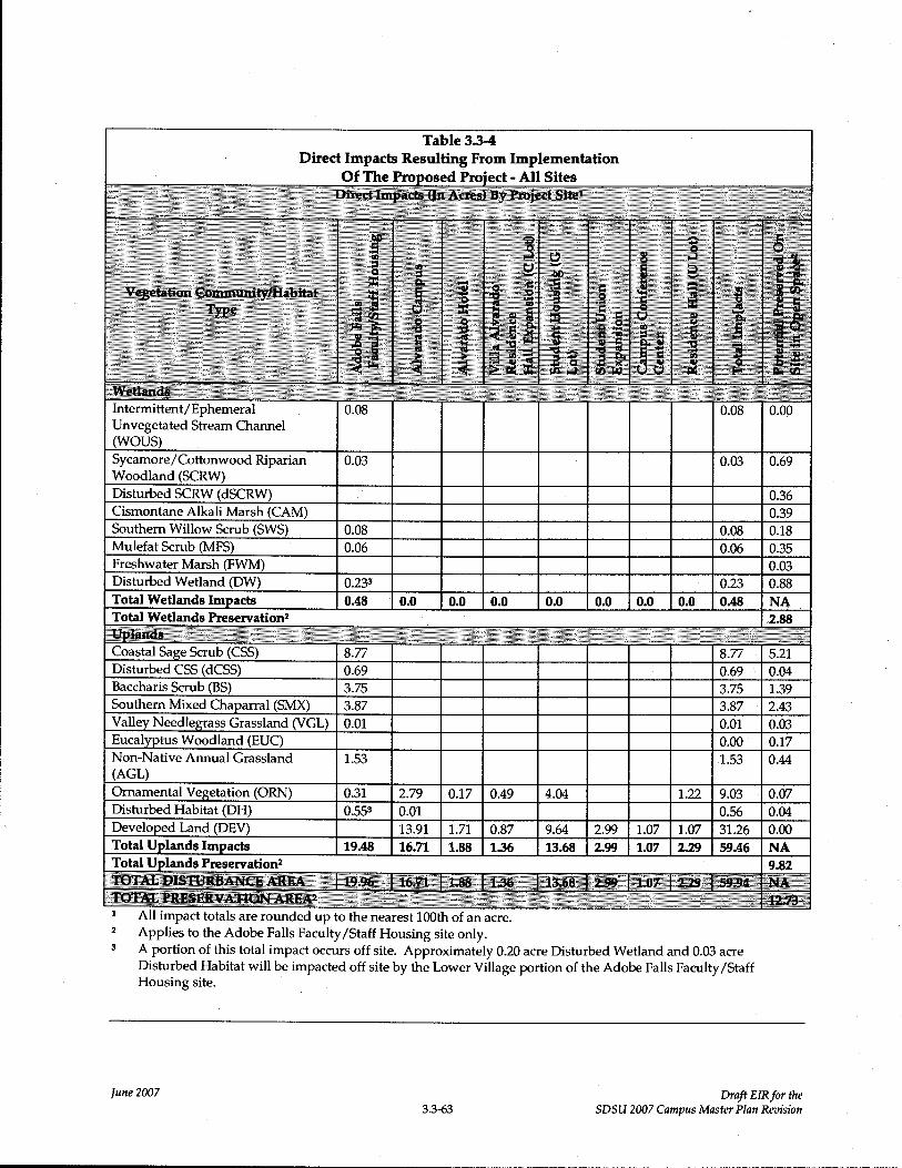
Table 3.3-4
Direct Impacts Resulting From Implementation Of The Prot,osed Proied - All Sites
~j-··i;· I
~r~~~-~i~i~~ E~I~
Intermittent/ Ephemeral 1 0.08 1 ·I I I I I I 1 0.08 0.00 Unvegetated Stream Channel OYOUS)
Sycamore/Cottonwood Riparian 0.03 1 I I I I I I 1 0.03 0.69 Woodland (SCRW) Disturbed SCRW (dSCRW) I I I I I I I I I 1 0.36 Cismontane Alkali Marsh (CAM) I I I I I I I I I 1 0.39 Southern Willow Scrub (SWS) 0.08 1 I I I I I I 1 0.08 0.18 Mulefat Scrub (MFS) 1 0.06 1 I I I I I I 1 0.06 0.35 Freshwater Marsh (FWM) I I I I I I I I I 1 0.03 Disturbed Wetland (DW) 0.233 1 I I I I I I 1 0.23 0.88 Total Wetlands Impacts 1 0.48 1 0.0 0.0 0.0 I 0.0 0.0 0.0 0.0 0.48 NA
Total Wetlands Preservationz 1 2.88
Coastal Sage Scrub (CSS) I 8.77 I I I I i I I I 8.77 1 5.21 Disturbed CSS (dCSS) 0.69 1 I I I I I I 1 0.69 1 0.04 Baccharis Scrub (BS) 1 3.75 1 I I i I I I 1 3.75 1.39
Southern Mixed Chaparral (SMX) 3.87 1 I I I I I I 1 3.87 1 2.43 Valley Needlegrass Grassland (VGL) 0.01 1 I I I I I I I 0.01 0.03
Woodland (EUC) I I I I I I I I I 0.00 1 0.17 Non-Native Annual Grassland 1.53 1 I I I I I I 1 1.53 0.44
(AGL)
Ornamental Vegetation (ORN) 0.31 1 2.79 0.17 0.49 4.04 1.22 9.03 1 0.07 Disturbed Habitat (DH) 0.553 0.01 1 I I I I I 1 0.56 0.04 Developed Land (DEV) 13.91 1.71 0.87 9.64 2.99 1.07 1.07 31.26 0.00
Total Uplands Impacts I 19.48 16.71 1.88 136 13.68 1 2.99 1 1.07 229 59.46 NA
Total Uplands Preservation2 1 9.82
i All impact totals areroundedupto;h~-;^';^~;-~ Z Applies to the Adobe Falls Faculty/Staff Housing site only.
A portion of this total impact occurs off site. Approximately 0.20 acre Disturbed Wetland and 0.03 acre Disturbed Habitat will be impacted off site by the Lower Village portion of the Adobe Falls Faculty/Staff Housing site.
lune 2007 Draft EIRfor the 3.3-63 SDSU 2007 Campus Master Plan Revision

3.3.6.1.2 Sensitive Plants
Implementation of the proposed project would result in direct impacts to all California adolphia
plants observed on the Adobe Falls Faculty/Staff Housing site (approximately 45 plants in
coastal sage scrub), as well as all San Diego County viguiera plants onsite (approximately 75
plants in coastal sage scrub). All San Diego marsh elder and southwestern spiny rush plants
observed onsite would be preserved onsite in their native wetlands habitats. No direct impacts
to any other state- or federally listed, rare, regionally sensitive, or endemic plant species would
occur as a result of project implementation.
3.3.6.1.3 Sensitive Wildlife
Implementation of the proposed project would result in direct impacts to one nesting pair of the
federally-listed threatened coastal California gnatcatcher and approximately 17.08 acres of
potential habitat for the species. The pair was observed on the east half of the Adobe Falls
Faculty/Staff Housing sit~ during focused surveys conducted onsite during the spring of 2007. Direct impacts will also occur on the Adobe Falls Faculty/Staff Housing site to approximately
18.61 acres of foraging habitat for red-tailed hawk, red-shouldered hawk, turkey vulture,
Cooper's hawk, and northern harrier, and potential nesting habitat for southern California
rufous-crowned sparrow, Bell's sage sparrow, and orange-throated whiptail. No direct impacts
to any other state- or federally listed, rare, or wildlife species of special concern would occur as
a result of project implementation.
3.3.6.1.4 Sensitive Habitats
All sensitive habitats that may be directly impacted by the project are located on the Adobe
Falls Faculty/Staff Housing site. Directly impacted sensitive wetland habitats total 0.61 acre
and include 0.03 acre sycamore/cottonwood riparian woodland, 0.08 acre ephemeral stream channel, 0.08 acre southern willow scrub, 0.06 acre mulefat scrub and 0.36 acre disturbed
wetlands. Directly impacted sensitive upland habitat communities total 18.62 acres-and include
8.77 acres coastal sage scrub, 0.69 acre disturbed coastal sage scrub, 3.87 acres southern mixed
chaparral, 3.75 acres baccharis scrub, 0.01 acre valley needlegrass grassland and 1.53 acre non-
native annual grassland.
3.3.6.1.3 Wildlife Corridors and Habitat Linkages
As stated previously, none of the component project sites function as a regional habitat linkage
or movement corridor for terrestrial species (birds, mammals, reptiles and amphibians, etc.) and
no direct impacts to existing wildlife corridors or habitat linkages are anticipated as a result of
project implementation.
lune 2007 Draft EIRfor the 3.3-64 SDSU 2007 Campus Master Plan Revision

3.3.6.2 Indirect Impacts (Short-Term and Long-Term)
Indirect impacts are difficult to identify and quantify, but are presumed to occur. They
primarily result from adverse "edge effects," and may be short-term indirect effects related to
construction or long-term indirect effects associated with development in proximity to
biological resources within natural open space. For the proposed project, it is assumedthat the
potential indirect impacts resulting from construction activities include dust, noise, and general
human presence that may temporarily disrupt species and habitat vitality and construction-
related soil erosion and runoff. With respect to these latter factors, however, mitigation is
proposed to require that all project grading will be subject to the typical restrictions and
requirements that address erosion and runoff, including the federal Clean Water Act, National
Pollution Discharge Elimination System (NPDES), and preparation of a Stormwater Pollution
Prevention Plan (SWPPP).
3.3.6.2.1 Sensitive Plants
Potential short-term indirect impacts to sensitive plants on the Adobe Falls Faculty/Staff
Housing Site may include increased erosion, dust and/or noise from construction. Excessive
dust could disrupt plant vitality in the short term, as well as construction-related soil erosion
and water runoff. Mitigation is proposed, however, that would require the implementation of
standard construction practices to control dust, erosion, and runoff, and will substantially
reduce these effects. Long-term indirect impacts on vegetation mostly may occur as a result of
trampling of vegetation by humans and domestic pets, invasions by exotic species, and
exposure to urban pollutants (e·8·· pesticides, urban runoff). Mitigation is proposed to require
that the open space areas preserved as part of the project will be fenced, and access to
surrounding open space will be largely limited to foot trails established as part of the overall
development plan. Access to the cismontane alkali marsh on the Adobe Falls Faculty/Staff
Housing Site must be limited by fencing or some other measure to protect both San Diego
marsh elder and southwestern spiny rush plants from excessive foot traffic. The introduction of
domesticated pets (e·8·, cats, dogs) to the area is not expected to create significant indirect
impacts on sensitive plants, but invasion by exotic species from surrounding landscaping could
potentially impact adjacent wetland areas not maintained by SDSU or its designee by lowering
native plant cover through the process of competitive exclusion. The cismontane alkali marsh
was recently restored through removal of an extensive pampas grass invasion, and due to the
presence of perennial water within the area, pampas grass or others exotic species that
commonly invade wetlands could establish.
lune 2007 Draft EIRfor the 3.3-65 SDSU 2007 Campus Master Plan Ratision

A final additional long-term indirect impact could be associated with a change in site hydrology
upstream of the cismontane all<ali marsh on the Adobe Falls Faculty/Staff Housing Site. The
marsh is supplied by overland flow during the rainy season and a steady flow of perched
groundwater during the summer months. The present site design preserves areas south of the
cismontane alkali marsh as open space, greatly reducing any potential for significant indirect
effects on the sensitive plant species onsite.
3.3.6.2.2 Sensitive Wildlife
Potential short-term indirect effects on sensitive wildlife may include increased noise from
construction. T~ere is a low to moderate potential for sensitive raptors or wading birds to nest
within riparian scrub adjacent to the proposed project and be indirectly affected by construction
noise. This noise could discourage foraging, roosting, breeding, or nesting behavior.
Construction noise could also affect sensitive passerine species with a moderate potential to
occur onsite including the southern California rufous-crowned sparrow.
Potential long-term indirect effects on sensitive wildlife may include a decreased prey base (e·8·,
insects for gnatcatcher) due to reduced habitat area, introduction of night lighting that may
adversely affect the activity of nocturnal animals, and increased presence of mesopredators (e.g.,
domesticated cats and dogs) within preserved open space areas around the proposed
development on the Adobe Falls Faculty/Staff Housing site. The coastal California gnatcatcher
is the only sensitive wildlife species observed on the site.
In addition, the native coastal sage scrub habitat located north of the proposed U Lot Residence
Hall site may potentially provide suitable habitat for the coastal California gnatcatcher. Indirect
impacts may occur to the species, if present, through prolonged construction noise on the
project site. This indirect impact may be considered significant, and would require mitigation.
3.3.6.2.3 Sensitive Habitats
Potential short-term indirect effects on sensitive habitats may include increased dust from
construction. As discussed above, it is anticipated that standard construction practices to reduce
dust will be employed for the project. Potential long-term indirect effects on sensitive habitats
may include introduction of non-native or invasive plant species, increased foot traffic in
wetland and upland preserve areas, drainage changes that result in substantially altered
hydrology in wetland or upland areas, reduction in fire frequencies for fire-dependent
community types, or loss of pollinators/seed dispersal mechanisms for plants within sensitive
habitat types.
lune 2007 Draft EIRfor the 3.3-66 SDSU 2007 Campus Master Plan Reoision

3.3.6.2.4 Wildlife Corridors and Habitat Linkages
None of the proposed project component sites function as a regional habitat linkage or movement corridor for terrestrial species (birds, mammals, reptiles and amphibians, etc.), and
therefore no indirect impacts to wildlife corridors or habitat linkages are anticipated.
3.3.6.2.5 Regional Planning
None of the proposed project sites are located within the MHPA, and therefore will not
indirectly affect assemblage of the MSCP preserve system. The Alvarado Campus development
plan will not be introducing a more intensive land use adjacent to the MHPA; a series of
buildings currently exists along this boundary, similar in size and height to the proposed plan.
3.3.7 ANALYSIS OF SIGNICANCE
3.3.7.1 Vegetation Communities
For the purpose of analyzing the significance of impacts to vegetation communities, all impacts
resulting from implementation of the project were considered as direct impacts. Each direct
impact is briefly analyzed below.
3.3.7.1.1 Unvegetated Ephemeral Stream Channel (Wetlands)
Implementation of the project would result in direct impacts to 0.08 acre of unvegetated
ephemeral stream channel. Ephemeral stream channel is regulated by ACOE, CDFG, and
RWQCB, generally with a "no net loss" of wetlands policy. Direct impacts to ephemeral stream
channel are considered significant and require mitigation.
3.3.7.1.2 Sycamore/Cottonwood Riparian Woodland (Wetlands)
Implementation of the project would result in direct impacts to 0.03 acre of
sycamore/cottonwood riparian woodland. Sycamore/cottonwood riparian woodland is
regulated by ACOE, CDFG, and RWQCB, generally with a "no net loss" Of wetlands policy.
Direct impacts to sycamore/cottonwood riparian woodland are considered significant and
require mitigation.
3.3.7.1.3 Southern Willow Scrub (Wetlands)
Implementation of the project would result in direct impacts to 0.08 acr~ of southern willow
scrub. Southern willow scrub is regulated by ACOE, CDFG, and RWQCB, generally with a "no
net loss" of wetlands policy. Direct impacts to southern willow scrub are considered significant
and require mitigation.
lune 2007 Draft EIRfor the 3.3-67 SDSU 2007 Campus Master Plan Revision

3.3.7.1.4 Mulefat Scrub (Wetlands)
Implementation of the project would result in direct impacts to 0.06 acre of mulefat scrub.
Mulefat scrub is generally regulated as a wetland by ACOE, CDFG, and RWQ%B with a "no net
loss" of wetlands policy. Direct impacts to mulefat scrub are considered significant and require
mitigation.
3.3.7.1.5 Disturbed Wetlands
Implementation of the project would result in direct impacts to 0.23 acre of disturbed wetlands.
Disturbed wetlands are regulated by ACOE, CDFG, and RWQCB, generally with a "no net loss"
of wetlands policy. Direct impacts to disturbed wetlands are considered significant and require
mitigation.
3.3.7.1.6 Coastal Sage Scrub/Disturbed Coastal Sage Scrub
Implementation of the project would result in direct impacts to 8.77 acres of coastal sage scrub
and 0.69 acre disturbed coastal sage scrub. Coastal sage scrub is considered a sensitive habitat
type that supports several sensitive wildlife species. The coastal sage scrub on the Adobe Falls
Faculty/Staff Housing site is occupied by the coastal California gnatcatcher. Direct impacts to
coastal sage scrub are considered significant, and require mitigation.
3.3.7.1.7 Baccharis Scrub
Implementation of the project would result in direct impacts to 3.75 acres of baccharis scrub.
Baccharis scrub is considered a form of coastal sage scrub. Direct impacts to baccharis scrub are
considered significant, and require mitigation.
3.3.7.1.8 Southern Mixed Chaparral
Implementation of the project would result in direct impacts to 3.87 acre of southern mixed
chaparral. Chaparral is a sensitive habitat type that supports some sensitive wildlife species.
Direct impacts to southern mixed chaparral are considered significant, and require mitigation.
3.3.7.1.9 Valley Needlegrass Grassland
Implementation of the project would result in direct impacts to 0.01 acre of valleyneedlegrass
grassland. Direct impacts to valley needlegrass grassland are considered significant because of
the limited distribution of this habitat onsite and within the region, and, therefore, require
mitigation.
lune 2007 Draft EIRfor the 3.3-68 SI)SU 2007 Campus Master Plan Revision

3.3.7.1.10 Non-Native Annual Grassland
Implementation of the project would result in direct impacts to 1.53 acres of non-native annual
grassland. Direct impacts to non-native annual grassland are considered significant because the
habitat supports extensive small mammal activity onsite and, therefore, require mitigation.
3.3.7.1.11 Ornamental Vegetation
Implementation of the project would result in direct impacts to 7.76 acres of ornamental
vegetation. Direct impacts to Ornamental vegetation are not considered significant and no
mitigation is required.
3.3.7.1.12 Disturbed Habitat
Implementation of the project would result in direct impacts to 0.56 acre of disturbed habitat.
Direct impacts to disturbed habitat are not considered significant and no mitigation is requiri~d.
3.3.7.1.13 Developed Land
Implementation of the project would result in direct impacts to 31.39 acres of developed land.
Direct impacts to developed land are not considered significant and no mitigation is required.
3.3.7.2 Sensitive Plants
Implementation of the project would result in the loss of 45 California adolphia plants and 75
San Diego County viguiera plants. California adolphia is a CNPS List 2.1 plant species,
indicating that the species is rare or endangered in California, but more common elsewhere and
that occurrences within California are seriously endangered. The plants occur on the Adobe
Falls Faculty/Staff Housing site, within approximately 0.21 acre of coastal sage scrub habitat.
This is a relatively small occurrence of the species, and the only occurrence on site. All plants
are expected to be directly lost due to development. San Diego County Viguiera is a CNPS List
4.2 species, indicating that it occurs with a limited distribution and that occurrences within
California are fairly endangered. The plants all occur on the Adobe Falls Faculty/Staff Housing
site within approximately 0.28 acre of coastal sagec scrub habitat. This too is a relatively small.
occurrence of the species, and is the only occurrence of the species onsite. All plants are
expected to be directly lost due to development. These species are rare but found in sufficient
numbers such that the potential for extinction is low at this time. Both species are considered
endangered throughout their range, but are more or less widespread outside of California.
The loss of 45 California adolphia plants and 75 San Diego County viguiera plants within
approximately 0.49 acre of coastal sage scrub on the Adobe Falls Faculty/Staff Housing site is
lune 2007 Draft EIRfor the 3.3-69 SDSU 2007 Campus Master Plan Revision

not considered significant. The loss would be taking most or all plants present on the Adobe
Falls Faculty/Staff Housing site, but this amount of habitat is relatively small and would not
contribute to the permanent loss of these species in California. These species are both regionally
sensitive and considered rare, but are found in sufficient numbers regionally, especially in
protected areas including the City of San Diego MHPA, that the potential for extinction due to
project impacts is low.
3.3.7.3 Sensitive Wildlife
Zn determining significance, the significance threshold applied is whether the project would
have a substantial adverse effect on the sensitive species and contribute substantially to the loss
of this species regionally. Some direct potential impacts are not considered significant for the
following reasons: (1) the suitable habitat to be impacted is relatively small and/or (2) the
species is widely distributed and common in its range. Direct potential impacts, which are
considered significant, are such because of the high sensitivity of the species (i.e., California
gnatcatcher or nesting raptors).
The proposed project would result in significant direct impacts to one sensitive wildlife species;
the federally-listed threatened coastal California gnatcatcher. A focused survey for coastal
California gnatcatcher was conducted onsite in March and April 201017, and one nesting pair of
the species was located onsite. Direct impacts to California gnatcatcher and 17.08 acres of
potential habitat for this species are considered significant because this species is federally-
listed threatened and impacts may contribute to, or result in, permanent loss of this species in
San Diego County. It is expected that project implementation would result in direct loss (take)
of one pair of California gnatcatcher. A "take" includes the direct loss of habitat for the species
on the Adobe Falls Faculty/Staff Housing site. Measures would be taken prior to project
construction to prevent the direct take of the species through physical harm or death.
The proposed project also may result in significant indirect impacts to sensitive wildlife species
including Cooper's hawk and northern harrier (among others), which have been observed
foraging on-site and have moderate potential to nest adjacent to the site. Each species may be
affected by construction-related noise while attempting to nest within riparian scrub adjacent to
the proposed project.
In addition, there could be temporary disruption to sensitive nesting passerine birds such as
southern California rufous-crowned sparrow and Bell's sage sparrow due to construction-
related noise. However, this potential indirect impact on sensitive nesting passerine birds
lune 2007 Drnp EIRfor the 3.3-70 SDSU 2007 Campus Master Plan Revision

would have a minor, temporary effect on these species. This potential temporary disruption to
nesting birds would not have a substantial adverse effect on these species; therefore, this
indirect impact is not considered significant. Direct impacts to approximately 18.61 acres of
potential habitat for southern California rufous-crowned sparrow, Bell's sage sparrow, and
orange-throated whiptail and are not considered significant. Although there is a moderate
potential for these species to occur, they have not been observed during general and focused
wildlife surveys separated by three years time, the potential habitat is fairly small, and these
species are widely distributed and common within their range.
Direct impacts to approximately 18.61 acres of foraging habitat on the Adobe Falls Faculty/Staff
Housing site for red-tailed hawk, red-shouldered hawk, turkey vulture, Cooper's hawk, and
northern harrier are not considered significant because the total amount of foraging habitat that
would be impacted is relatively small and would not contribute significantly to the loss of
foraging habitat or the sensitive species that utilize this habitat-within the region.
3.3.7.4 Wildlife Corridors and Habitat Linkages
None of the proposed component project sites function as an important habitat linkage or
wildlife corridor. The project would not have a significant adverse effect on habitat linkages or wildlife corridors.
3.3.7.5 Regional Planning
As discussed above, although the site of the proposed Alvarado Campus and U-Lot Residence
Hall sites are located adjacent to the MHPA, each of the eight project component sites are
located wholly outside of the MHPA. Therefore, the proposed project would not have a
significant direct or indirect effect on the MHPA.
3.3.7.6 Cumulative Impacts
Cumulative Impacts refer to incremental environmental effects of two or more projects when
considered together. These impacts taken individually may be minor, but collectively can be
significant as they occur over a period of time.
The proposed project includes the development of eight individual component sites including
seven developed areas (Alvarado Campus, Alvarado Hotel, Villa Alvarado Residence Hall
Expansion, Student Housing, Student Union Expansion, Campus Conference Center and U Lot
Residence Hall sites) and one undeveloped site (Adobe Falls Faculty/Staff Housing site). Re-
development of previously developed areas on or adjacent to the SDSU campus is not expected
lune 2007 Draft EIRfar the 3.3-71 SDSU 2007 Campus Master Plan Revision

to result in cumulative impacts to vegetative communities, sensitive plants, sensitive wildlife,
sensitive habitats or the MHPA in conjunction with other projects occurring adjacent to the
campus area. None of these areas contain sensitive biological resources that would be impacted
by the project and, therefore, the project's impacts would not be cumulatively considerable.
Development of the largely undeveloped Adobe Falls Faculty/Staff Housing site also is not
expected to result in cumulative impacts to vegetative communities, sensitive plants, sensitive
wildlife, sensitive habitats or the MHPA beyond the direct and indirect impacts identified in this EIR. The proposed project would be consistent with the Multiple Species Conservation
Program ("MSCP"), which was developed to eliminate cumulative impacts resulting from
development throughout the region. Development of the Adobe Falls Faculty/Staff Housing
site would not occur in areas designated for the MHPA and, thereby, is consistent with the
overall intent of the MSCP, which is to focus development in non-MHPA land and mitigate for any impacts to natural habitat within MHPA land where wildlife movement and plant
population survival is more appropriate and probable.
3.3.8 MITIGATION MEASURES
The following mitigation measures, as summarized in Table 3.3.-5, Proposed Mitigation - All
Sites, are proposed to reduce the identified significant effects to vegetation communities,
wetlands and sensitive species that would result with implementation of the proposed project to a levelbelow significant:
Iune2007 DraftElXforthe 3.3-72 SDSU 2007 Campus Master Plan Reuision

Table 3.3-5
-All Sites
0.01 acre 1 2:1 0.01 acre 0.01 acre creation 0.02 acre
ephemeral I I enhancement unvegetated
WOUS
0.06 acre mulefat 3:1 0.04 acre 0.02 acre creation 0;06 acre
scrub I I enhancement
0.08 acre southem 1 3:1 1 0.16 acre 0.08 acre creation 0.24 acre
willow scrub I I enhancement
Sub-total - 0.15 n/a 0.21 acre 0.11 acre creation 1 0.32 acre
acre I I enhancement
wetlands/WOUS
0.09 acre baccharis 2:1 none 0.18 acre 0.18 acre
scrub I I I preservation
3.30 acres coastal 1 2:1 1 4.32 acres 2.28 acres 6.60 acres
sane scrub I I preservation I preservation
0.01 acre 2:1 none 0.02 acre 1 0.02 acre
disturbed coastal I I I preservation sane scrub
1.46 acres 1:1 0.50 acre 0.96 acre i 1.46 acres
southern mixed I I preservation preservation cha
0.04 acre non- I 1:1 1 0.02 acre 1 0.02 acre 0.04 acre
native annual I I preservation preservation land
0.31 acre I n/a I none none 1 0.00 acre
ornamental
Sub-total - 5~21 n/a 4.84 acres 3.46 acres 830 acres
acres uplands I I preservation preservation
Total-5.36 acres I n/a 8.62 acres
0.07 acre 1 2:1 0.07 acre creation none 1 0.14 acre
intermittent/ephe 0.07 acre meral unvegetated enhancement
WOUS
0.03 acre 1 3:1 1 0.03acrecreation I none 0.09 acre
disturbed 0.06 acre
sycamore/cotton I I enhancement wood riparian
woodland
lune 2007 Draft EIRfor the 3.3-73 SDSU 2007 Campus Master Plan Revision

Table 3.3-5
-All Sites
0.23 acre 2:1 0.10 acre creation 0.13 acre creation 0.46 acre
disturbed wetland 0.23 acre
- 0.20 acre off site, enhancement 0.03 acre on site
Sub-total - 0.33 n/a 0.20 acre creation 0.13 acre creation 0.69 acre
acre wetlands 036 acre
enhancement
3.66 acres 2:1 1.39 acres 1 5.93 acres 7.32 acres
baccharis scrub I I Dreservation
5.47 acres coastal 2:1 0.88 acres 10.06 acres 10.94 acres
saae scrub I I Dreservation
0.67 acre 2:1 0.04 acre 1 1.30 acres 1.34 acres
disturbed coastal I I preservation preservation sae~e scrub
2.41 acres 1:1 1 1.93 acres 0.48 acre 2.41 acres
southern mixed preservation I preservation cha
0.01 acre valley 1 2:1 1 0.02 acre I none 1 0.02 acre needlegrass I I preservation
land
1.49 acres non- 1:1 0.41 acre 1.08 acres 1.49 acres
native annual preservation preservation land
0.48 acre n/a none I none 0.00 acre
disturbed habitat
- 0.07 acre off site, 0.41 acre on site
Sub-total- 14.19 n/a 4.67 acres 18.85 acres 1 23.52 acres
acres uplands preservation preservation
ProjectTotals - I n/a 0.57 acre on site 0.26 acre off site 33.94 acres total All Sites wetlands wetlands creation mitigation 0.48 acre enhancement 2231 acre off site
wetlandsMTOUS I I 0.20acreonsite I uplands impacts wetlands creation preservation
19.40 acres I I 9,51acres onsite
uplands impacts 4 1 I uplands
1- Wetlands impacts rrsulting from the Upper Village site will be mitigated, to the extent possible, within open space lands on the Lower Village site.
Uplands impacts resulting from the Upper and Lower Village sites will be mitigated, to the extent possible, on the site where the impacts occur.
2 - Off site mitigation will be comprised of purchase of wetlands/uplands mitigation lands (credits) within agency approved mitigation banks.
3 - Total includes approximately 0.23 acre of offsite impacts.
4- Impact total does not include ornamental vegetation or developed areas. No mitigation is proposed forthese impacts, which occur on all SDSU project
sites (see Table 3.3-4).
lune 2007 Draft EIRfor the 33-74 SDSU 2007 Campus Master Plan Revision

3.3.8.1 Mitigation for Direct Impacts
3.3.8.1.1 Vegetation Communities
Proposed mitigation for significant direct impacts to vegetative communities (including
wetlands) may be accomplished through on-site and/or off-site preservation, enhancement, or
creation of habitat. The following proposed mitigation measures for direct impacts resulting
from the project include both on-site preservation of upland habitats (outside of the MHPA)
within the Adobe Falls Faculty/Staff Housing Upper and Lower Village sites, and off-site
preservation of upland habitats (within the MHPA)r
BR-1 Prior to commencement of grading activities on the Adobe Falls Faculty/Staff
Housing Upper Village site, SDSU, or its designee, shall, presen~e, or cause to be
preserved, a total of 9.51 acres of onsite native habitats. The preservation areas
shall occur outside of the Multi-Habitat Planning Area ("MHPA"), within the
proposed open space on the Adobe Falls Faculty/Staff Housing Site, and shall
include 5.20 acres of coastal sage scrub, 1.39 acres of baccharis scrub, 2.43 acres of
southern mixed chaparral, 0.02 acre of valley needlegrasS grassland, and 0.43
acre non-native annual grassland.
SDSU also shall create up to 0.20 acre of wetlands along the western boundary of
the Adobe Falls Faculty/Staff Housing site within existing eucalyptus woodland
and disturbed habitat on the Lower Village site, and shall enhance up to 0.56
acres of wetlands within existing disturbed sycamore/cottonwood riparian
woodland and disturbed wetlands habitats on the Lower Village site.
BR-2 Prior to commencement of grading activities on the Adobe Falls Faculty/Staff
Housing site, SDSU, or its designee, shall create 0.26 acre of wetlands off site,
which requirement may be satisfied through the purchase of wetlands mitigation
credits at an approved offsite mitigation bank, preferably within the San Diego River watershed.
SDSU also shall purchase and preserve a total of 22.31 acres of uplands habitat,
which shall include gnatcatcher occupied Diegan coastal sage scrub habitat
offsite within the Multi-Habitat Planning Area ("MHPA"). The purchase and
preservation may occur on Mt. Fortuna, adjacent to Mission Trails Regional Park,
which would contribute to the overall assembly of the MHPA preserve system in
San Diego County and ensure that a sensitive area is preserved in perpetuity.
Ittne 2007 Draft EIRfor the 3.3-75 SDSU 2007 Campus Master Plan Revision
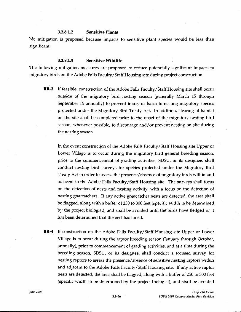
3.3.8.1.2 Sensitive Plants
No mitigation is proposed because impacts to sensitive plant species would be less than
significant.
3.3.8.1.3 Sensitive Wildlife
The following mitigation measures are proposed to reduce potentially significant impacts to
migratory birds on the Adobe Falls Faculty/Staff Housing site during project construction:
BR-3 If feasible, construction of the Adobe Falls Faculty/Staff Housing site shall occur
outside of the migratory bird nesting season (generally March 15 through
September 15 annually) to prevent injury or harm to nesting migratory species
protected under the Migratory Bird Treaty Act. In addition, clearing of habitat
on the site shall be completed prior to the onset of the migratory nesting bird
season, whenever possible, to discourage and/or prevent nesting on-site during
the nesting season.
In the event construction of the Adobe Falls Faculty/Staff Housing site Upper or
Lower Village is to occur during the migratory bird general breeding season, prior to the commencement of grading activities, SDSU, or its designee, shall
conduct nesting bird surveys for species protected under the Migratory Bird
Treaty Act in order to assess the presence/absence of migratory birds within and
adjacent to the Adobe Falls Faculty/Staff Housing site. The surveys shall focus
on the detection of nests and nesting activity, with a focus on the detection of
nesting gnatcatchers. If any active gnatcatcher nests are detected, the area shall
be flagged, along with a buffer of 250 to 300 feet (specific width to be determined
by the project biologist), and shall be avoided until the birds have fledged or it
has been determined that the nest has failed.
BR-4 If construction on the Adobe Falls Faculty/Staff Housing site Upper or Lower
Village is to occur during the raptor breeding season aanuary through October,
annually), prior to commencement of grading activities, and at a time during the
breeding season, SDSU, or its designee, shall conduct a focused survey for
nesting raptors to assess the presence/absence of sensitive nesting raptors within
and adjacent to the Adobe Falls Faculty/Staff Housing site. If any active raptor
nests are detected, the area shall be flagged, along with a buffer of 250 to 300 feet
(specific width to be determined by the project biologist), and shall be avoided
lune 2007 Draft EIRfor the 33-76 SDSU 2007 Campus Master Plan Revision

until the birds have fledged, or it has been determined that the nest has failed.
3.3.8.2 Mitigation for Indirect Impacts
Mitigation measures to reduce potential long-term indirect impacts of the project on sensitive
biological resources are presented below. Note that all sensitive biological resources occur on
the Adobe Falls Faculty/Staff Housing site, and adjacent to the U Lot Residence Hall site.
3.3.8.2.1 Vegetation Communities
Potentially significant long-term indirect impacts to vegetation communities and sensitive
habitat types include the introduction of non-native or invasive species; increased foot traffic
and other disturbances in wetland and upland preserve areas; and drainage changes that result
in altered hydrology in wetland and upland habitat areas. Mitigation measures to reduce long-
term indirect impacts associated with implementation of the Adobe Falls Faculty/Staff Housing
component of the proposed project to below a level of significance include ~he following measures:
BR-5 During the respective design phase of the proposed Adobe Falls Faculty/Staff
Housing Upper and Lower Village sites, SDSU, or its designee, shall not locate
non-native or invasive plant species in landscaping adjacent to native habitat
areas, on slopes adjacent to Alvarado Creek, or in upland habitat next to Interstate 8.
BR-6 During the respective design phase of the proposed Adobe Falls Faculty/Staff
Housing Upper and Lower Village sites, SDSU, or its designee, shall develop a
system of trails within open space preserved areas that encourage foot traffic
within the least sensitive habitat types, while providing views·of more sensitive
areas adjacent to the proposed development.
BR-7 During the respective design phase of the proposed Adobe Falls Faculty/Staff
Housing Upper and Lower Villages, SDSU, or its designee, shall develop a Storm
Water Pollution Prevention Plan ("SWPPP"), including a Water Quality
Management Plan, to address potential water quality impacts.
BR-8 During the respective design phase of the proposed Adobe Falls Faculty/Staff
Housing Upper and Lower Villages, SDSU, or its designee, shall develop buffers
between the proposed development and preserved onsite wetlands. The
lune 2007 Draft EIRfor the 3.3-77 SDSU 2007 Campus Master Plan Revision

perennial drainage along the west boundary of the site shall include a minimum
25-foot wide buffer along the edge of the development to maintain wildlife
habitat functions, and a general 100-foot buffer shall be maintained along the
floodplain of Alvarado Creek to avoid the existing Federal Emergency
Management Area ("FEMA") floodplain.
BR-9 During the respective design phase of the proposed Adobe Falls Faculty/Staff
Housing Upper and Lower Villages, SDSU, or its designee, shall install outdoor
lighting so that it faces away from preserved areas on the periphery of the Adobe
Falls Faculty/Staff Housing Site, and shall use low-pressure sodium lights if
possible to decrease negative effects associated with artificial night lighting.
3.3.8.2.2 Sensitive Plants
Potentially significant long-term indirect impacts to sensitive plants include trampling by
humans and invasion by exotic plants. The following mitigation measures will reduce these
potential impacts to a level below significant.
BR-10 During the respective design phase of the proposed Adobe Falls Faculty/Staff
Housing Upper and Lower Villages, SDSU, or its designee, shall provide native
landscaping in areas adjacent to preserved native habitat.
BR-11 During the respective design phase of the proposed Adobe Falls Faculty/Staff
Housing Upper and Lower Villages, SDSU, or its designee, shall. develop fencing
at the interface between the development boundary and any native habitat to
preclude human intrusion into preserved areas.
The preparation of a Storm Water Pollution Prevention Plan, as provided in mitigation measure
r BR-7, also will serve to reduce potentially significant long-term indirect impacts to sensitive
plants.
3.3.8.2.3 Sensitive Wildlife
Potentially significant long-term indirect impacts to sensitive wildlife include the introduction
of night lighting that could interfere with the activities of nocturnal wildlife, and increased
predation by domesticated pets. The following mitigation measures are proposed to reduce
these potential impacts to a levelbelow significant:
lune 2007 Draft EIRfor the 3.3-78 SDSU 2007 Campus Master Plan Reoision

BR-12 During the respective design phase of the proposed Adobe Falls Faculty/Staff
Housing Upper and Lower Villages, SDSU, or its designee, shall develop policies
and design measures to reduce the intrusion of domestic pets into native habitat
areas, including sensitive habitat signage, installing well-defined trails along
habitat areas so recreationaiists/dog walkers understand trail limits, and
incorporating leash laws.
BR-13 Prior to construction of the proposed U Lot Residence Hall site, SDSU, or its
designee, shall conduct a focused survey for the coastal California gnatcatcher on
the coastal sage scrub covered slopes adjacent to the site. The surveys shall be
conducted to determine the presence or absence of any nesting gnatcatchers
within 500 feet of the proposed construction site. If nests are located within this
distance, noise mitigation measures may be required to avoid significant indirect
impacts to the gnatcatcher during the nesting season.
The installation of outdoor lighting so that it faces away from the preserved areas, as provided
in mitigation measure BR-9, also will serve to reduce potentially significant long-term indirect
impacts to sensitive wildlife.
3.3.8.3 Resource Management and Monitoring
A portion of the Adobe Falls Faculty/Staff Housing site will be preserved as open space for
natural habitat values, and will become part of the SDSU Field Stations Program, an educational
and research program for undergraduate and graduate students that includes restoration and
management of the lands for the long-term preservation of native flora and fauna. Under the
Field Stations Program, the habitat and hydrology of the Adobe Falls site would be managed
and restored`to the maximum extent practicable, while providing an opportunity for research
and education related to restoration and management. The Program would include watershed,
wildlife and habitat monitoring to help inform management and restoration activities on the
property. The Field Stations Program is described furtherin EIR Appendix D.
3.3.9 LEVEL OF SIGNIFICANCE AE~I1ER MITIGATION
With implementation of the proposed mitigation measures identified in this section,
development of the proposed project would not result in any unavoidable significant impacts to
biological resources.
lune 2007 Draft EIRfor the 3.3-79 SDSU 2007 Campus Master Plan Revision


