SECTION 4.3.9: RISK ASSESSMENT – SUBSIDENCE/SINKHOLE DMA 2000 Hazard Mitigation Plan Update – Lehigh Valley, Pennsylvania 4.3.9-1 March 2013 4.3.9 Subsidence/Sinkhole This section provides a profile and vulnerability assessment for the subsidence/sinkhole hazard. According to the U.S. Geological Survey (USGS), “ground failure” is the term used to describe zones of ground cracking, fissuring, and localized horizontal and vertical permanent ground displacement that may be caused by surface rupture along faults; secondary movement on shallow faults; shaking-induced compaction of natural deposits in sedimentary basins and river valleys; liquefaction of loose, sandy sediment (USGS, 2005); landslides; and land subsidence and sinkholes. For the purpose of this HMP, the ground failure hazard to which the Lehigh Valley is vulnerable includes, but is not limited to, land subsidence or sinkholes, which are further defined as follows: Land subsidence can be defined as the sudden sinking or gradual downward settling of the earth’s surface with little or no horizontal motion, owing to the subsurface movement of earth materials (USGS, 2007). Subsidence often occurs through the loss of subsurface support in Karst terrain, which may result from a number of natural and human-caused occurrences. Karst is a distinctive topography in which the landscape is largely shaped by the dissolving action of water on carbonate bedrock (usually limestone, dolomite, or marble). Sinkholes, the type of subsidence most frequently seen in the Lehigh Valley, are a natural and common geologic feature in areas with underlying limestone, carbonate rock, salt beds, or other rocks that are soluble in water. Over periods of time measured in thousands of years, the carbonate bedrock can be dissolved through acidic rain water moving in fractures or cracks in the bedrock. This creates larger openings in the rock through which water and overlying soil materials will travel. Over time, the deposited soils compromise the strength of the bedrock, until it is unable to support the land surface above, and a collapse or sinkhole occurs. In this example the sinkhole occurs naturally, but in other cases the root causes of a sinkhole are anthropogenic, especially those that involve changes to the water balance of an area including: over-withdrawal of groundwater, diverting surface water from a large area and concentrating it in a single point, artificially creating ponds of surface water, and drilling new water wells. These actions can also serve to accelerate the natural processes of bedrock degradation, which can have a direct impact on sinkhole creation. Both natural and man-made sinkholes can occur without warning. Slumping or falling fence posts, trees, or foundations; sudden formation of small ponds; wilting vegetation; discolored well water; and/or structural cracks in walls and floors, are all specific signs that a sinkhole is forming. They can form into steep-walled holes to bowl or cone shaped depressions. When sinkholes occur in developed areas they can cause severe property damage, injury and loss of life, disruption of utilities, and damage to roadways. In urban and suburban areas, sinkholes can destroy highways and buildings. 4.3.9.1 Location and Extent Forty-seven of the 62 municipalities in Lehigh and Northampton counties (or about 76% of municipalities) are underlain entirely or in part by carbonate bedrock. The carbonate rock formations have developed karst landforms, resulting in significant land subsidence problems. These limestone and dolomite formations underlie the heart of the Lehigh Valley’s urban core, and soils produced from the weathering of carbonate bedrock also provide the area’s most fertile farmland. The bedrock itself serves as a source of raw material for the cement industry. The Saucon Valley of Lehigh County is one of the most common sinkhole locations throughout Pennsylvania.
DMA 2000 Hazard Mitigation Plan Update – Lehigh Valley, Pennsylvania 4.3.9-1 March 2013
4.3.9 Subsidence/Sinkhole
This section provides a profile and vulnerability assessment for the subsidence/sinkhole hazard. According to the U.S. Geological Survey (USGS), “ground failure” is the term used to describe zones of ground cracking, fissuring, and localized horizontal and vertical permanent ground displacement that may be caused by surface rupture along faults; secondary movement on shallow faults; shaking-induced compaction of natural deposits in sedimentary basins and river valleys; liquefaction of loose, sandy sediment (USGS, 2005); landslides; and land subsidence and sinkholes. For the purpose of this HMP, the ground failure hazard to which the Lehigh Valley is vulnerable includes, but is not limited to, land subsidence or sinkholes, which are further defined as follows:
Land subsidence can be defined as the sudden sinking or gradual downward settling of the earth’s surface with little or no horizontal motion, owing to the subsurface movement of earth materials (USGS, 2007). Subsidence often occurs through the loss of subsurface support in Karst terrain, which may result from a number of natural and human-caused occurrences. Karst is a distinctive topography in which the landscape is largely shaped by the dissolving action of water on carbonate bedrock (usually limestone, dolomite, or marble).
Sinkholes, the type of subsidence most frequently seen in the Lehigh Valley, are a natural and common geologic feature in areas with underlying limestone, carbonate rock, salt beds, or other rocks that are soluble in water. Over periods of time measured in thousands of years, the carbonate bedrock can be dissolved through acidic rain water moving in fractures or cracks in the bedrock. This creates larger openings in the rock through which water and overlying soil materials will travel. Over time, the deposited soils compromise the strength of the bedrock, until it is unable to support the land surface above, and a collapse or sinkhole occurs. In this example the sinkhole occurs naturally, but in other cases the root causes of a sinkhole are anthropogenic, especially those that involve changes to the water balance of an area including: over-withdrawal of groundwater, diverting surface water from a large area and concentrating it in a single point, artificially creating ponds of surface water, and drilling new water wells. These actions can also serve to accelerate the natural processes of bedrock degradation, which can have a direct impact on sinkhole creation.
Both natural and man-made sinkholes can occur without warning. Slumping or falling fence posts, trees, or foundations; sudden formation of small ponds; wilting vegetation; discolored well water; and/or structural cracks in walls and floors, are all specific signs that a sinkhole is forming. They can form into steep-walled holes to bowl or cone shaped depressions. When sinkholes occur in developed areas they can cause severe property damage, injury and loss of life, disruption of utilities, and damage to roadways. In urban and suburban areas, sinkholes can destroy highways and buildings.
4.3.9.1 Location and Extent
Forty-seven of the 62 municipalities in Lehigh and Northampton counties (or about 76% of municipalities) are underlain entirely or in part by carbonate bedrock. The carbonate rock formations have developed karst landforms, resulting in significant land subsidence problems. These limestone and dolomite formations underlie the heart of the Lehigh Valley’s urban core, and soils produced from the weathering of carbonate bedrock also provide the area’s most fertile farmland. The bedrock itself serves as a source of raw material for the cement industry. The Saucon Valley of Lehigh County is one of the most common sinkhole locations throughout Pennsylvania.
DMA 2000 Hazard Mitigation Plan Update – Lehigh Valley, Pennsylvania 4.3.9-2 March 2013
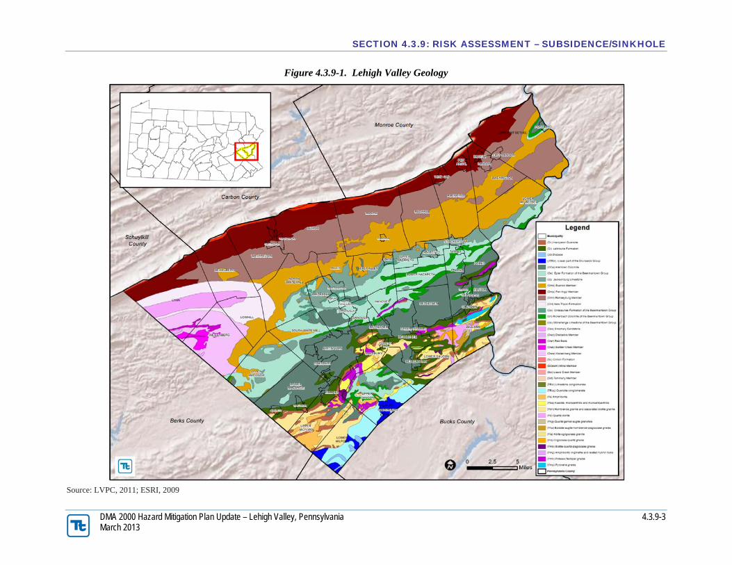
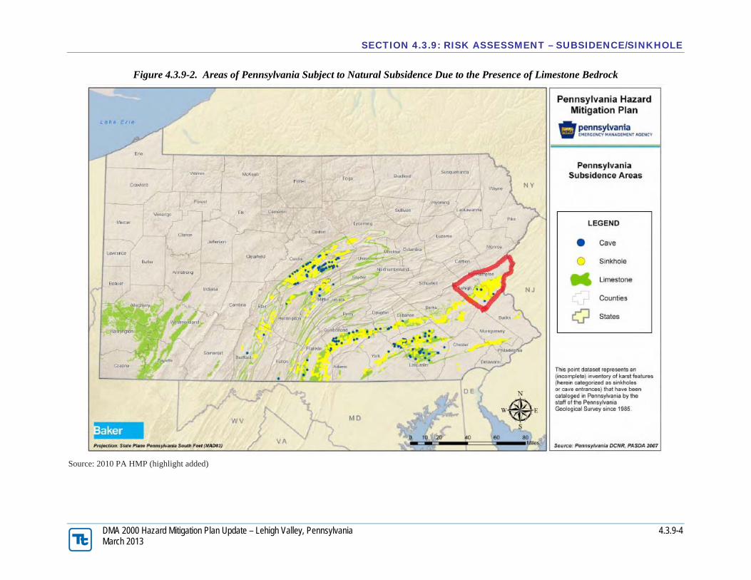
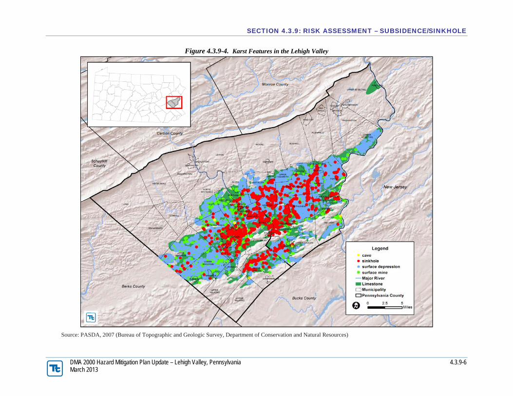
Figure 4.3.9-1 illustrates the geology across the Lehigh Valley. Figure 4.3.9-2 illustrates the areas of Pennsylvania subject to natural subsidence due to the presence of limestone bedrock. Locations of known subsidence and sinkhole events as well as cave locations are also shown.
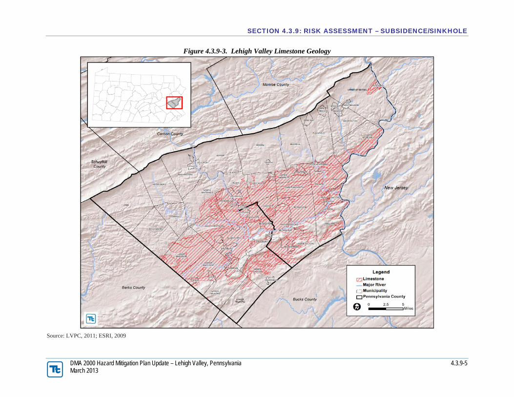
More specifically, Figure 4.3.9-3 shows the distribution of limestone in the Lehigh Valley and the areas vulnerable to subsidence. Figure 4.3.9-4 shows the areas of the region that are underlain by carbonate bedrock that are characterized by closed depressions, sinkholes and caves (karst features).
DMA 2000 Hazard Mitigation Plan Update – Lehigh Valley, Pennsylvania 4.3.9-8 March 2013
In summary, in Lehigh County, 19 of the 25 municipalities and approximately 80,399 acres are within the carbonate area. In Northampton County, 29 of 38 municipalities with approximately 87,516 acres are within the carbonate area for a total of 167,915 acres (262.4 square miles) in the Lehigh Valley. In Lehigh County, only five (5) of the 19 municipalities have less than 50% of their total acres in carbonate areas. These include Lower Milford Township, North Whitehall Township, Salisbury Township, Upper Milford Township and Weisenberg Township. Both Lower Milford Township and Weisenberg Township have less than 5% of their total acres in a carbonate area and, therefore, have a much lower hazard risk than the other municipalities.
In Northampton County, only eight (8) of the 29 municipalities have less than 50% of their total acres underlain by carbonate bedrock. These include Allen Township, Bushkill Township, Lower Mt. Bethel Township, Lower Saucon Township, Moore Township, Plainfield Township, Upper Mt. Bethel Township, Williams Township, and the Borough of Hellertown. Of these, Bushkill Township, Moore Township, Plainfield Township and Upper Mt. Bethel Township have less than 5% of their total acres in a carbonate area and also have a much lower hazard risk than the other municipalities. For purposes of this plan, we have assumed that the higher the percentage of carbonate bedrock in a municipality, the higher the risk for sinkhole formation.
While fewer karst features have been mapped in existing urban areas, human activity can often be the cause of a subsidence or sinkhole event. Furthermore, the lack of karst features exhibited in maps of urban areas is likely a result of development activities that disguise, cover, or fill existing features rather than an absence of the features themselves (PADCNR, 2003). Leaking water pipes or structures that convey storm-water runoff may also result in areas of subsidence as the water dissolves substantial amounts of rock over time. In some cases, construction, land grading or earthmoving activities that cause changes in stormwater flow can trigger sinkhole events. Subsidence or sinkhole events may occur in the presence of mining activity, especially in areas where the cover of a mine is thin, even in areas where bedrock is not necessarily conducive to their formation. Piggott and Eynon (1978) indicated that sinkhole development normally occurs where the interval to the ground surface is less than three to five times the thickness of the extracted seam and the maximum interval is up to ten times the thickness of the extracted seam. Sub-surface (i.e. underground) extraction of materials such as oil, gas, coal, metal ores (i.e. copper, iron, and zinc), clay, shale, limestone, or water may result in slow-moving or abrupt shifts in the ground surface.
4.3.9.2 Range of Magnitude
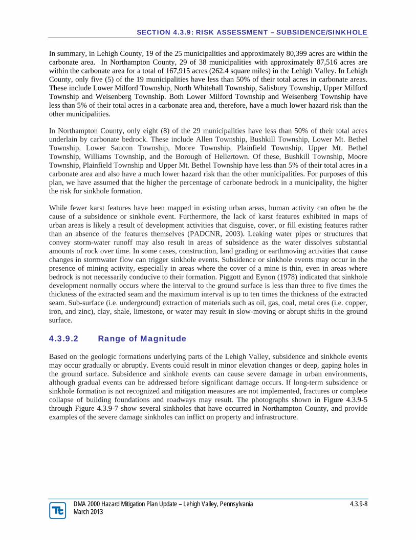
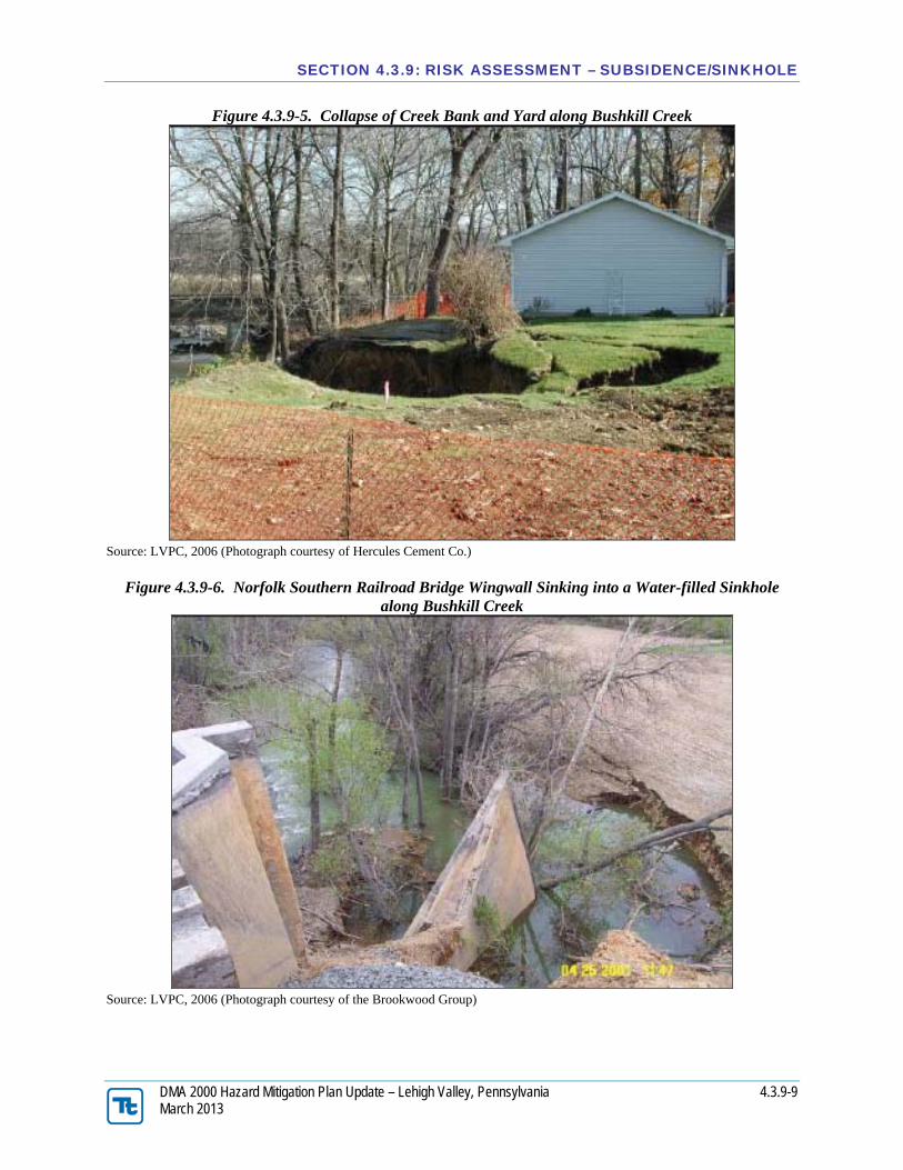
Based on the geologic formations underlying parts of the Lehigh Valley, subsidence and sinkhole events may occur gradually or abruptly. Events could result in minor elevation changes or deep, gaping holes in the ground surface. Subsidence and sinkhole events can cause severe damage in urban environments, although gradual events can be addressed before significant damage occurs. If long-term subsidence or sinkhole formation is not recognized and mitigation measures are not implemented, fractures or complete collapse of building foundations and roadways may result. The photographs shown in Figure 4.3.9-5 through Figure 4.3.9-7 show several sinkholes that have occurred in Northampton County, and provide examples of the severe damage sinkholes can inflict on property and infrastructure.
DMA 2000 Hazard Mitigation Plan Update – Lehigh Valley, Pennsylvania 4.3.9-10 March 2013
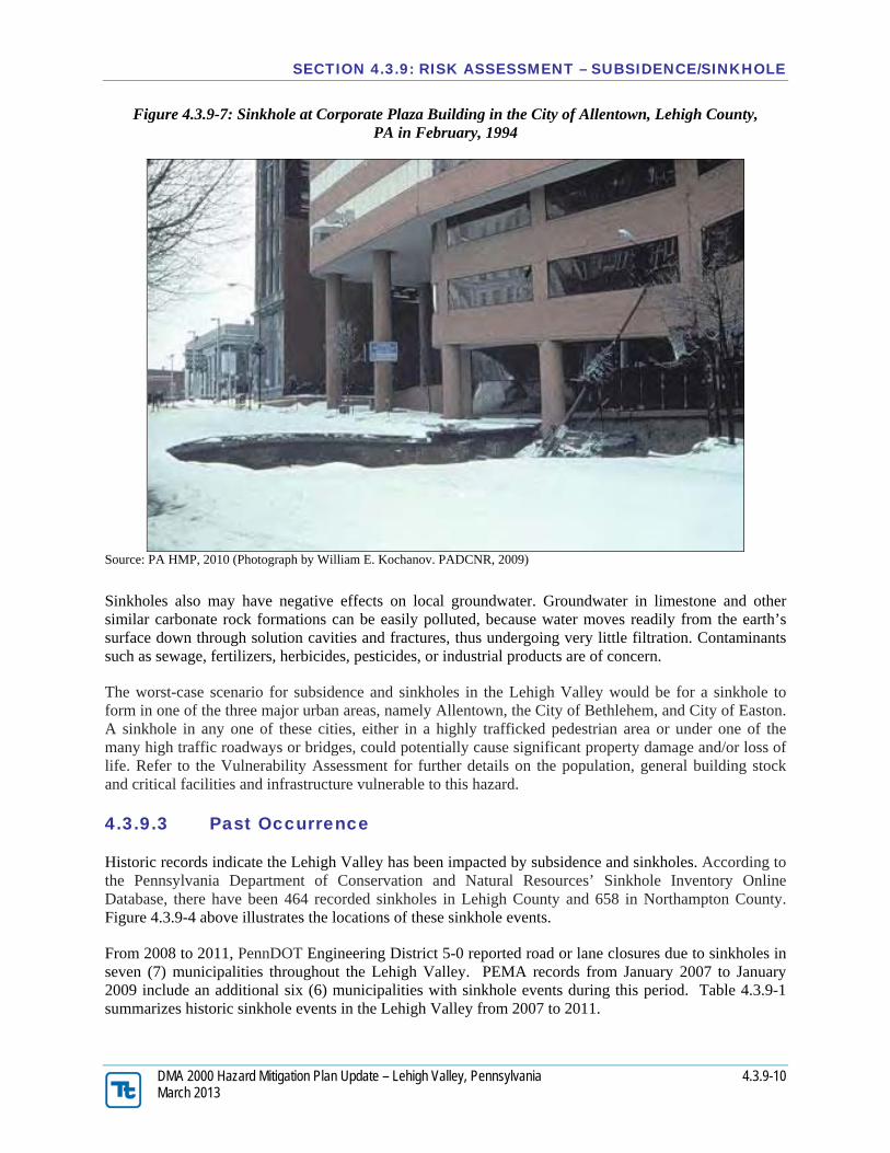
Figure 4.3.9-7: Sinkhole at Corporate Plaza Building in the City of Allentown, Lehigh County, PA in February, 1994
Source: PA HMP, 2010 (Photograph by William E. Kochanov. PADCNR, 2009)
Sinkholes also may have negative effects on local groundwater. Groundwater in limestone and other similar carbonate rock formations can be easily polluted, because water moves readily from the earth’s surface down through solution cavities and fractures, thus undergoing very little filtration. Contaminants such as sewage, fertilizers, herbicides, pesticides, or industrial products are of concern.
The worst-case scenario for subsidence and sinkholes in the Lehigh Valley would be for a sinkhole to form in one of the three major urban areas, namely Allentown, the City of Bethlehem, and City of Easton. A sinkhole in any one of these cities, either in a highly trafficked pedestrian area or under one of the many high traffic roadways or bridges, could potentially cause significant property damage and/or loss of life. Refer to the Vulnerability Assessment for further details on the population, general building stock and critical facilities and infrastructure vulnerable to this hazard.
4.3.9.3 Past Occurrence
Historic records indicate the Lehigh Valley has been impacted by subsidence and sinkholes. According to the Pennsylvania Department of Conservation and Natural Resources’ Sinkhole Inventory Online Database, there have been 464 recorded sinkholes in Lehigh County and 658 in Northampton County. Figure 4.3.9-4 above illustrates the locations of these sinkhole events.
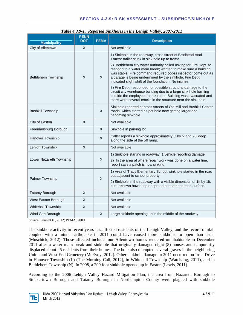
From 2008 to 2011, PennDOT Engineering District 5-0 reported road or lane closures due to sinkholes in seven (7) municipalities throughout the Lehigh Valley. PEMA records from January 2007 to January 2009 include an additional six (6) municipalities with sinkhole events during this period. Table 4.3.9-1 summarizes historic sinkhole events in the Lehigh Valley from 2007 to 2011.
DMA 2000 Hazard Mitigation Plan Update – Lehigh Valley, Pennsylvania 4.3.9-11 March 2013
Table 4.3.9-1. Reported Sinkholes in the Lehigh Valley, 2007-2011
Municipality
PENN DOT PEMA Description
City of Allentown X Not available
Bethlehem Township X X
1) Sinkhole in the roadway, cross street of Brodhead road. Tractor trailer stuck in sink hole up to frame.
2) Bethlehem city water authority called asking for Fire Dept. to respond to a water main break; wanted to make sure a building was stable. Fire command required codes inspector come out as a garage is being undermined by the sinkhole. Fire Dept. indicated slight shift of the foundation. No injuries.
3) Fire Dept. responded for possible structural damage to the circuit city warehouse building due to a large sink hole forming outside the employees break room. Building was evacuated and there were several cracks in the structure near the sink hole.
Bushkill Township X Sinkhole reported at cross streets of Old Mill and Bushkill Center roads, which started as pot hole now getting larger and becoming sinkhole.
City of Easton X Not available
Freemansburg Borough X Sinkhole in parking lot.
Hanover Township X Caller reports a sinkhole approximately 6' by 5' and 20' deep along the side of the off ramp.
Lehigh Township X Not available
Lower Nazareth Township X
1) Sinkhole starting in roadway. 1 vehicle reporting damage.
2) In the area of where repair work was done on a water line, report says a patch is now sinking.
Palmer Township X
1) Area of Tracy Elementary School, sinkhole started in the road but adjacent to school property;
2) Sinkhole in the roadway with a visible dimension of 1ft by 1ft, but unknown how deep or spread beneath the road surface.
Tatamy Borough X Not available
West Easton Borough X Not available
Whitehall Township X Not available
Wind Gap Borough X Large sinkhole opening up in the middle of the roadway.
Source: PennDOT, 2012; PEMA, 2009
The sinkhole activity in recent years has affected residents of the Lehigh Valley, and the record rainfall coupled with a minor earthquake in 2011 could have caused more sinkholes to open than usual (Muschick, 2012). Those affected include four Allentown homes rendered uninhabitable in December 2011 after a water main break and sinkhole that originally damaged eight (8) houses and temporarily displaced about 25 residents from their homes. The hole also disrupted several graves in the neighboring Union and West End Cemetery (McEvoy, 2012). Other sinkhole damage in 2011 occurred on Irma Drive in Hanover Township (L) (The Morning Call, 2012), in Whitehall Township (Watchdog, 2011), and in Bethlehem Township (N). In 2008, a 200 foot sinkhole opened up in Easton (Lewis, 2011).
According to the 2006 Lehigh Valley Hazard Mitigation Plan, the area from Nazareth Borough to Stockertown Borough and Tatamy Borough in Northampton County were plagued with sinkhole
DMA 2000 Hazard Mitigation Plan Update – Lehigh Valley, Pennsylvania 4.3.9-12 March 2013
problems in the early to mid-2000’s. The new Nazareth Area Middle School on Tatamy Road had a sinkhole in its parking lot that was expensive and difficult to fix. Other occurrences in Northampton County included sinkholes opening up on three (3) residential properties near Newburg Road in Lower Nazareth Township. Sinkholes opened up on farmland near the border of Palmer and Upper Nazareth Townships threatening a Nazareth Borough Municipal Authority sewer line. Sinkholes damaged roadways in both Townships. Damage amounts for these events are not known.
Sinkholes along the Bushkill Creek led to the closure of the bridge on the main road between Tatamy Borough and Stockertown Borough in 2000. During the time when PENNDOT was attempting to repair the sinkholes near the bridge, a large sinkhole opened up in the rear yard of a residence to the south and west of the bridge, and a portion of the creek bank adjacent to the property collapsed. The damage extended from the creek bank to the location of the original sinkhole repair.
In terms of monetary damages, the worst sinkhole event on record was reported in January 2004. A sinkhole caused structural damage to the Route 33 Bridge over the Bushkill Creek. PENNDOT closed the bridge and determined the bridge needed to be demolished and replaced. The southbound bridge was also replaced for a total project cost of about $6 million. The total project cost was approximately $6 million. This event resulted in a disaster declaration by the Governor.
On December 8, 2004, a large sinkhole opened up on St. John Street in Easton. A two-block section of the road was closed when a 200-foot long and 30-foot deep sinkhole opened. An apartment building with seven (7) units nearby had to be demolished. The state allocated $300,000 for the road repair work.
The February 1994 event in the City of Allentown, shown in Figure 4.3.9-7, is one of the worst known events in Pennsylvania. The sinkhole measured 100-feet long, 50-feet wide and 20-feet deep and collapsed a portion of 7th Street and the adjoining new Corporate Plaza Building in downtown Allentown. The building was ultimately demolished and replaced with a parking lot. Damage amounts are not known.
News reports identified 13 sinkholes or clusters of sinkholes that had been active during the late 1980s. The sinkholes ranged in size from one in the City of Bethlehem, that measured three feet in diameter with a depth of five feet, to one in Upper Saucon Township that measured 120 feet in diameter with a depth of 55 feet.
In seven (7) instances, sinkholes engulfed public roads. In five of these seven instances the collapse of the road was accompanied by the disruption of underground utility lines as the lines broke or service was cut-off to prevent problems. The roads damaged were located in Macungie Borough, Allentown, Upper Saucon Township, and Hanover Township (L), Easton, City of Bethlehem and Bethlehem Township. In each instance the road was closed for repairs. While some repairs could be accomplished quickly, others involved repair periods as long as three years (Upper Saucon Township) before the damage could be fixed.
According to the State hazard mitigation plan, the road in Upper Saucon Township cost nearly $800,000 to repair and a new sinkhole opened outside the repair area within six months. These sinkholes also damaged privately-owned structures. A sinkhole occurrence damaged a church and a college dormitory in Allentown. In the case of the dormitory, 51 students had to be relocated for nearly one month. Homes in the City of Bethlehem, Hanover Township (L), and Bethlehem Township were damaged. More specific details on these events are not known.
These sinkhole event descriptions are just a sampling of some of the sinkhole occurrences in the Lehigh Valley. Many others have occurred over the years. It should be noted that many other sinkhole
DMA 2000 Hazard Mitigation Plan Update – Lehigh Valley, Pennsylvania 4.3.9-13 March 2013
occurrences go unreported as they occur on private property and do not endanger structures such as in farm fields and woodlots.
4.3.9.4 Future Occurrence
Sinkhole occurrence is a continuing phenomenon and is fairly common in the carbonate areas of the Lehigh Valley, and the probability of a sinkhole forming in the Lehigh Valley is high. As these areas become increasingly developed, and as more people move out of the Boroughs and into the Townships, the strain on underground aquifers will increase. This will pose an even greater threat for sinkholes in those areas resulting from groundwater depletion.
Based on geological conditions, subsidence events are likely to occur in the future for the areas of the Lehigh Valley underlain by carbonate bedrock and experiencing increased development. It would be difficult to calculate potential losses for all existing buildings, critical facilities and infrastructure due to sinkhole formation as the hazard area amounts to approximately one third of the entire Lehigh Valley. However, the future occurrence of subsidence and sinkholes is considered unlikely as defined by the Risk Factor Methodology probability criteria (refer to Section 4.4).
4.3.9.5 Vulnerability Assessment
To understand risk, a community must evaluate what assets are exposed or vulnerable in the identified hazard area. The following section discusses the potential impact of the subsidence and sinkhole hazard on the Lehigh Valley including:
Overview of vulnerability Data and methodology used for the evaluation Impact on: (1) life, health and safety of residents, (2) general building stock, (3) critical facilities,
(4) economy and (5) future growth and development Effect of climate change on vulnerability Further data collections that will assist understanding this hazard over time
4.3.9.5.1 Overview of Vulnerability
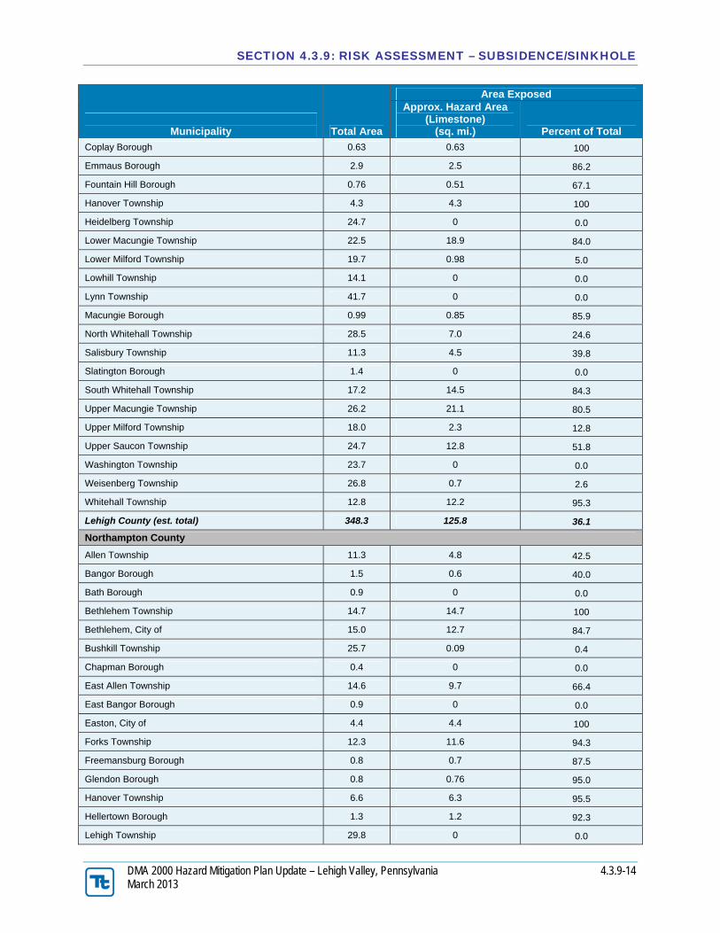
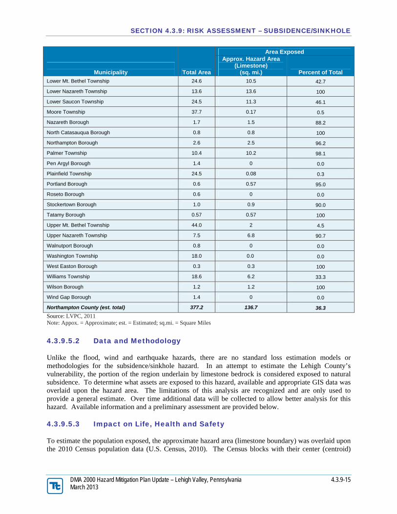
Approximately 35% of the Lehigh Valley is underlain by carbonate bedrock. The carbonate rock formations have developed karst landforms, resulting in significant land subsidence problems. Table 4.3.9-2 below summarizes the areas within Lehigh Valley underlain by limestone and within the subsidence/sinkhole hazard area defined for this planning effort.
Table 4.3.9-2. Area Located in the Approximate Subsidence/Sinkhole Hazard Area
DMA 2000 Hazard Mitigation Plan Update – Lehigh Valley, Pennsylvania 4.3.9-15 March 2013
Municipality Total Area
Area Exposed Approx. Hazard Area
(Limestone) (sq. mi.) Percent of Total
Lower Mt. Bethel Township 24.6 10.5 42.7
Lower Nazareth Township 13.6 13.6 100
Lower Saucon Township 24.5 11.3 46.1
Moore Township 37.7 0.17 0.5
Nazareth Borough 1.7 1.5 88.2
North Catasauqua Borough 0.8 0.8 100
Northampton Borough 2.6 2.5 96.2
Palmer Township 10.4 10.2 98.1
Pen Argyl Borough 1.4 0 0.0
Plainfield Township 24.5 0.08 0.3
Portland Borough 0.6 0.57 95.0
Roseto Borough 0.6 0 0.0
Stockertown Borough 1.0 0.9 90.0
Tatamy Borough 0.57 0.57 100
Upper Mt. Bethel Township 44.0 2 4.5
Upper Nazareth Township 7.5 6.8 90.7
Walnutport Borough 0.8 0 0.0
Washington Township 18.0 0.0 0.0
West Easton Borough 0.3 0.3 100
Williams Township 18.6 6.2 33.3
Wilson Borough 1.2 1.2 100
Wind Gap Borough 1.4 0 0.0
Northampton County (est. total) 377.2 136.7 36.3
Source: LVPC, 2011 Note: Appox. = Approximate; est. = Estimated; sq.mi. = Square Miles
4.3.9.5.2 Data and Methodology
Unlike the flood, wind and earthquake hazards, there are no standard loss estimation models or methodologies for the subsidence/sinkhole hazard. In an attempt to estimate the Lehigh County’s vulnerability, the portion of the region underlain by limestone bedrock is considered exposed to natural subsidence. To determine what assets are exposed to this hazard, available and appropriate GIS data was overlaid upon the hazard area. The limitations of this analysis are recognized and are only used to provide a general estimate. Over time additional data will be collected to allow better analysis for this hazard. Available information and a preliminary assessment are provided below.
4.3.9.5.3 Impact on Life, Health and Safety
To estimate the population exposed, the approximate hazard area (limestone boundary) was overlaid upon the 2010 Census population data (U.S. Census, 2010). The Census blocks with their center (centroid)
DMA 2000 Hazard Mitigation Plan Update – Lehigh Valley, Pennsylvania 4.3.9-16 March 2013
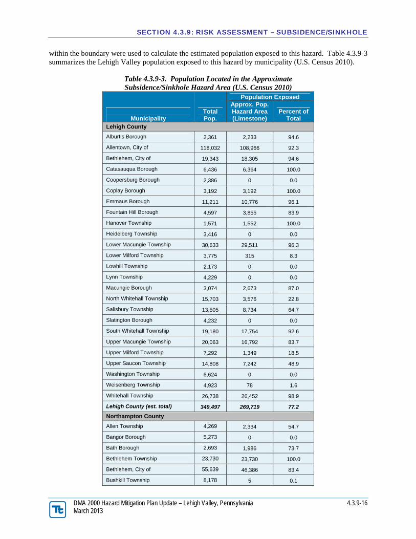
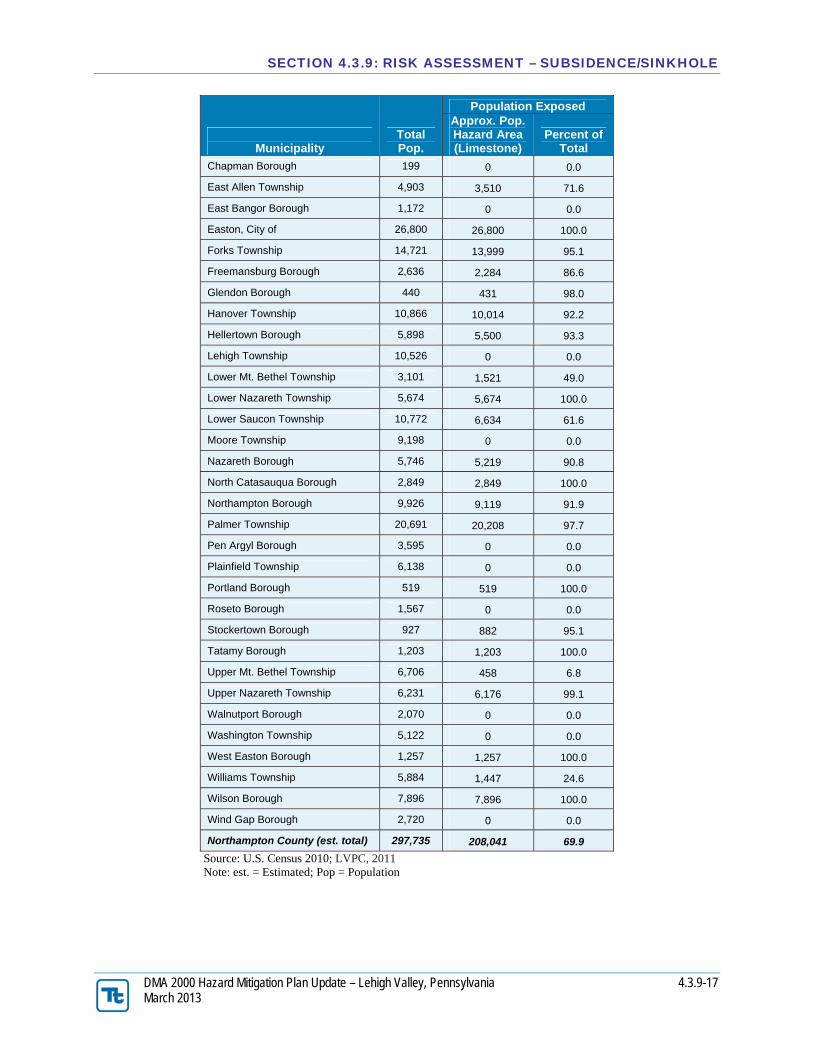
within the boundary were used to calculate the estimated population exposed to this hazard. Table 4.3.9-3 summarizes the Lehigh Valley population exposed to this hazard by municipality (U.S. Census 2010).
Table 4.3.9-3. Population Located in the Approximate Subsidence/Sinkhole Hazard Area (U.S. Census 2010)
Municipality
Total Pop.
Population Exposed Approx. Pop. Hazard Area (Limestone)
DMA 2000 Hazard Mitigation Plan Update – Lehigh Valley, Pennsylvania 4.3.9-18 March 2013
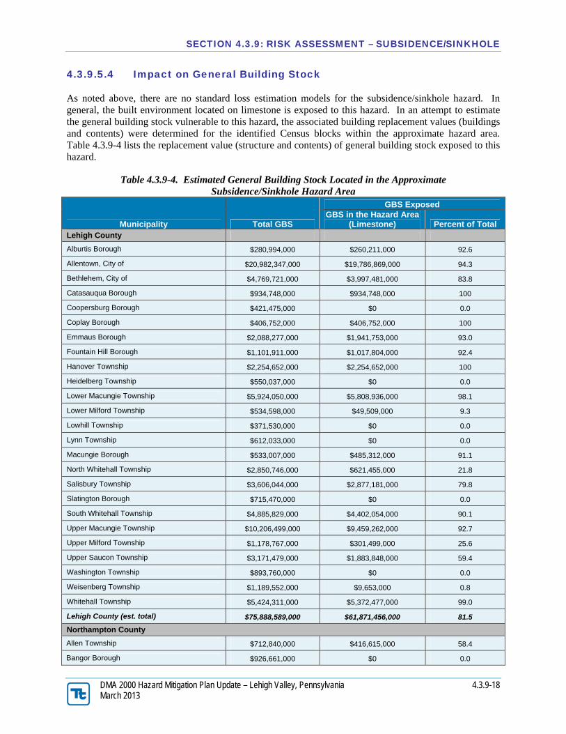
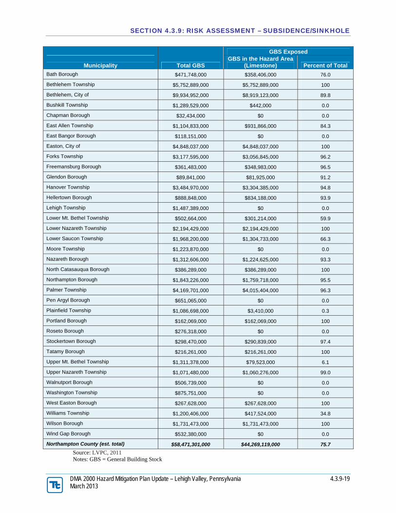
4.3.9.5.4 Impact on General Building Stock
As noted above, there are no standard loss estimation models for the subsidence/sinkhole hazard. In general, the built environment located on limestone is exposed to this hazard. In an attempt to estimate the general building stock vulnerable to this hazard, the associated building replacement values (buildings and contents) were determined for the identified Census blocks within the approximate hazard area. Table 4.3.9-4 lists the replacement value (structure and contents) of general building stock exposed to this hazard.
Table 4.3.9-4. Estimated General Building Stock Located in the Approximate Subsidence/Sinkhole Hazard Area
Municipality Total GBS
GBS Exposed GBS in the Hazard Area
(Limestone) Percent of Total Lehigh County
Alburtis Borough $280,994,000 $260,211,000 92.6
Allentown, City of $20,982,347,000 $19,786,869,000 94.3
Bethlehem, City of $4,769,721,000 $3,997,481,000 83.8
Catasauqua Borough $934,748,000 $934,748,000 100
Coopersburg Borough $421,475,000 $0 0.0
Coplay Borough $406,752,000 $406,752,000 100
Emmaus Borough $2,088,277,000 $1,941,753,000 93.0
Fountain Hill Borough $1,101,911,000 $1,017,804,000 92.4
DMA 2000 Hazard Mitigation Plan Update – Lehigh Valley, Pennsylvania 4.3.9-20 March 2013
Please note this data does not include agricultural buildings for Northampton County.
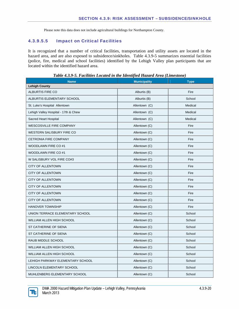
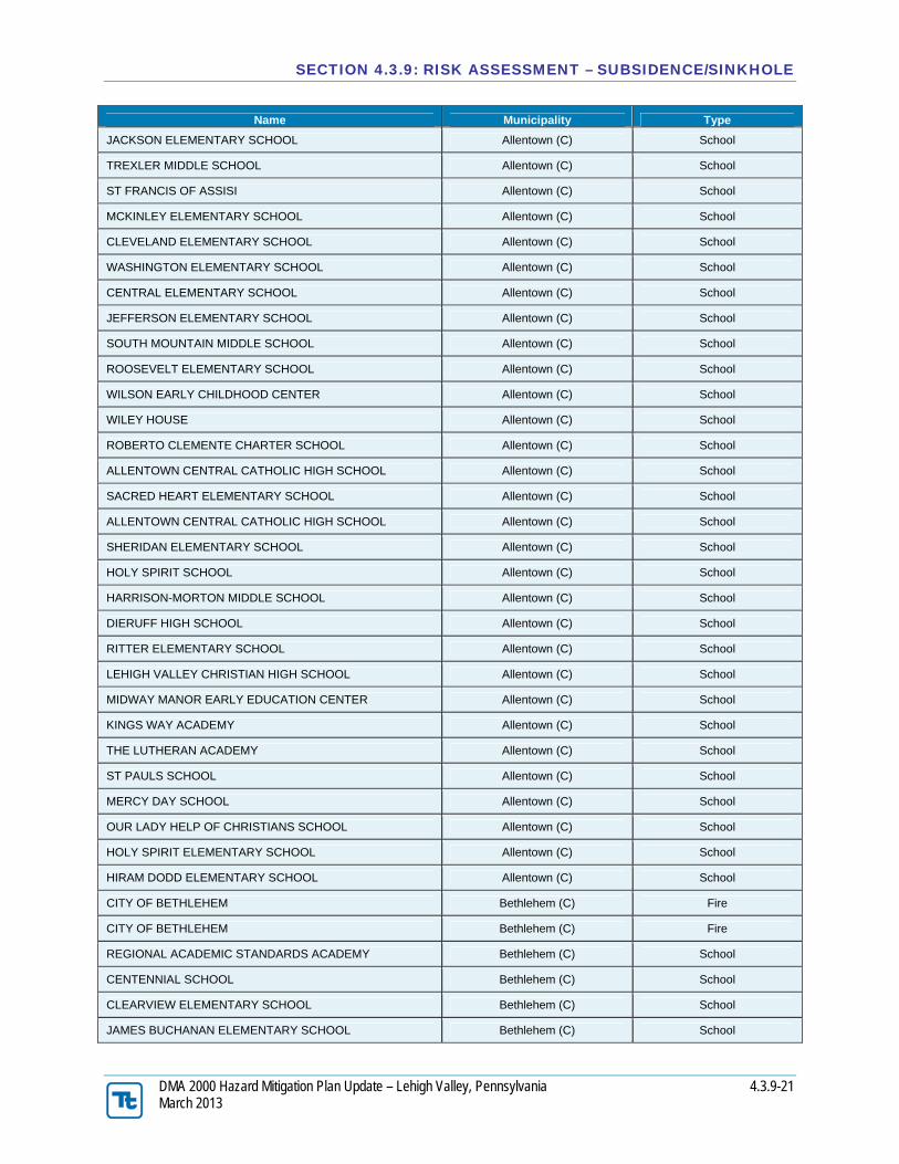
4.3.9.5.5 Impact on Critical Facilities
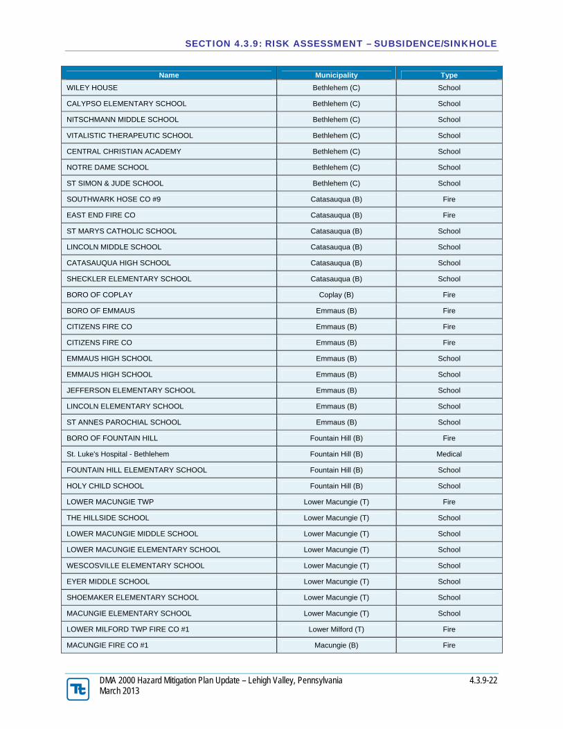
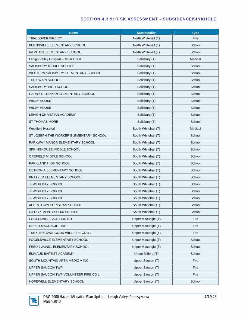
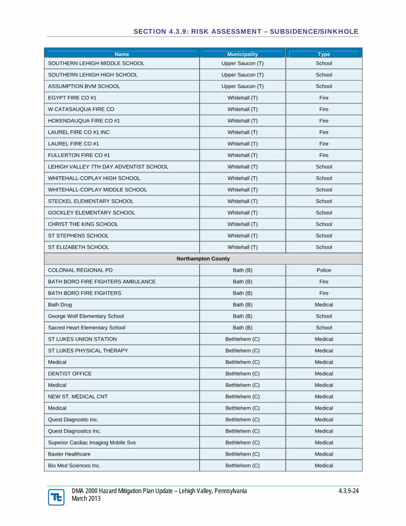
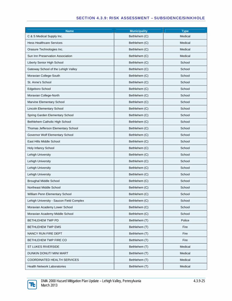
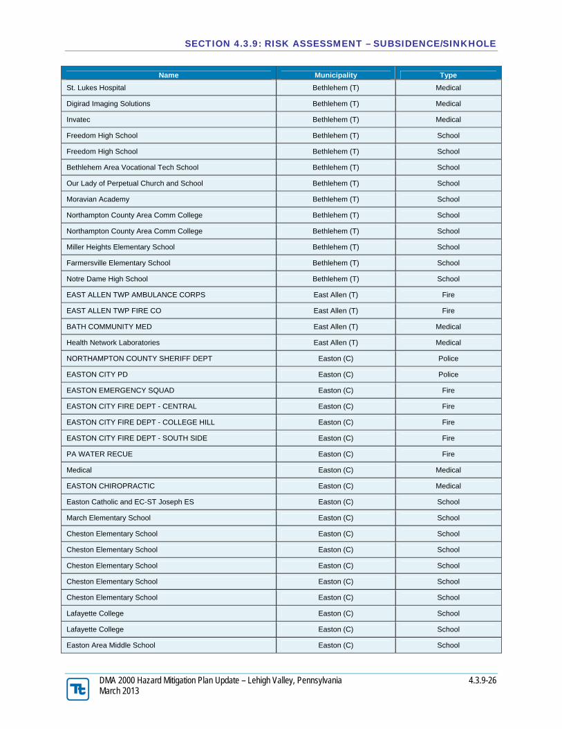
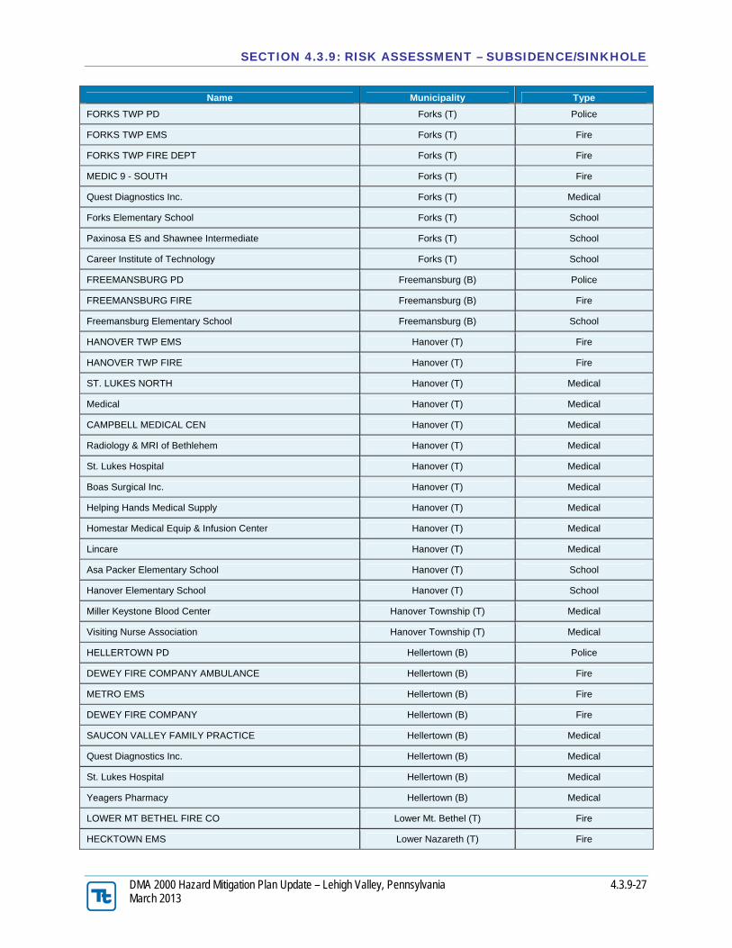
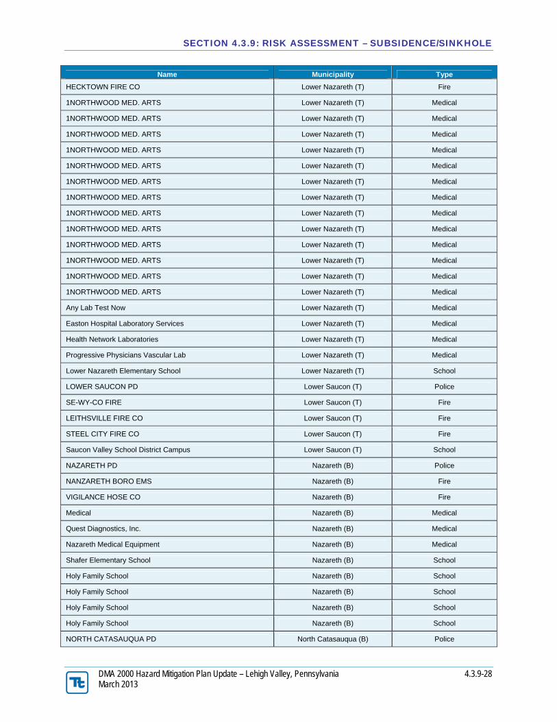
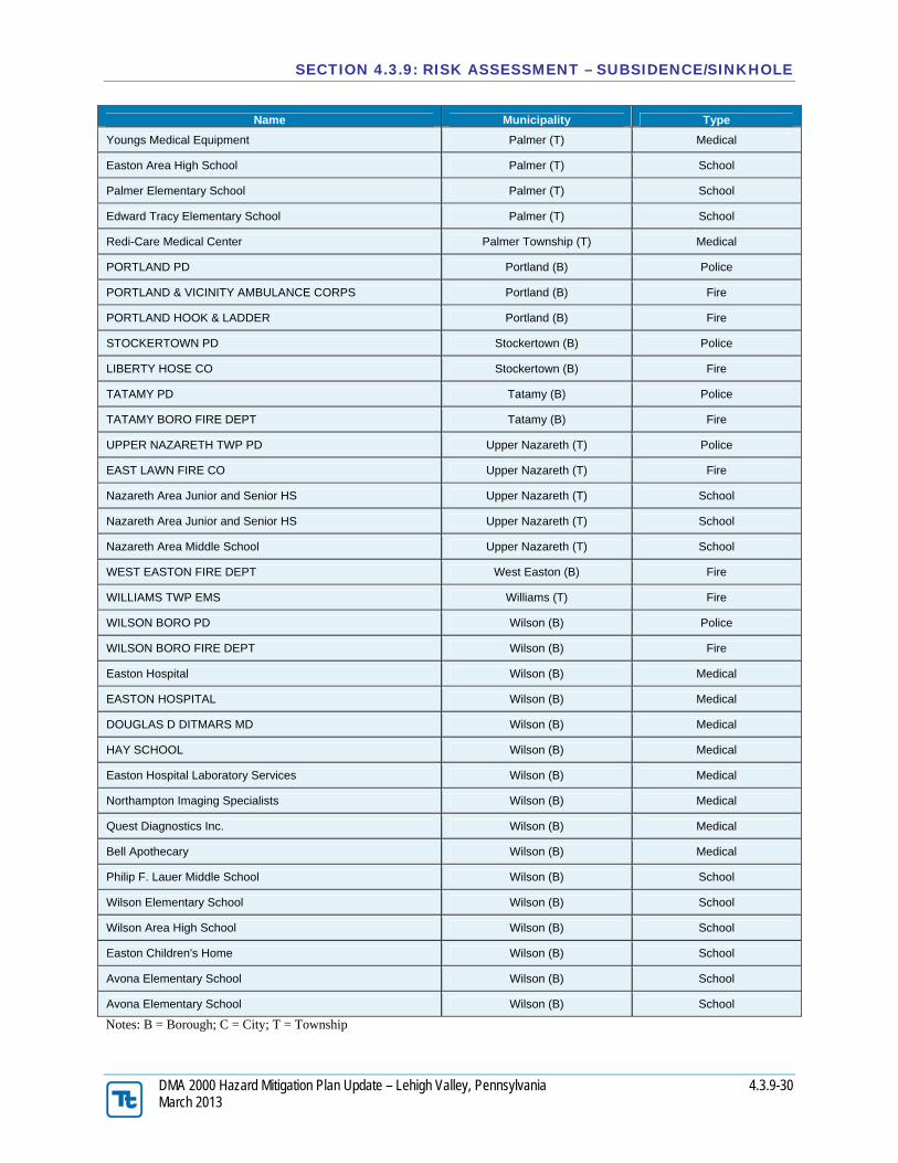
It is recognized that a number of critical facilities, transportation and utility assets are located in the hazard area, and are also exposed to subsidence/sinkholes. Table 4.3.9-5 summarizes essential facilities (police, fire, medical and school facilities) identified by the Lehigh Valley plan participants that are located within the identified hazard area.
Table 4.3.9-5. Facilities Located in the Identified Hazard Area (Limestone) Name Municipality Type
Lehigh County
ALBURTIS FIRE CO Alburtis (B) Fire
ALBURTIS ELEMENTARY SCHOOL Alburtis (B) School
St. Luke's Hospital Allentown Allentown (C) Medical
Lehigh Valley Hospital - 17th & Chew Allentown (C) Medical
Sacred Heart Hospital Allentown (C) Medical
WESCOSVILLE FIRE COMPANY Allentown (C) Fire
WESTERN SALISBURY FIRE CO Allentown (C) Fire
CETRONIA FIRE COMPANY Allentown (C) Fire
WOODLAWN FIRE CO #1 Allentown (C) Fire
WOODLAWN FIRE CO #1 Allentown (C) Fire
W SALISBURY VOL FIRE CO#3 Allentown (C) Fire
CITY OF ALLENTOWN Allentown (C) Fire
CITY OF ALLENTOWN Allentown (C) Fire
CITY OF ALLENTOWN Allentown (C) Fire
CITY OF ALLENTOWN Allentown (C) Fire
CITY OF ALLENTOWN Allentown (C) Fire
CITY OF ALLENTOWN Allentown (C) Fire
HANOVER TOWNSHIP Allentown (C) Fire
UNION TERRACE ELEMENTARY SCHOOL Allentown (C) School
WILLIAM ALLEN HIGH SCHOOL Allentown (C) School
ST CATHERINE OF SIENA Allentown (C) School
ST CATHERINE OF SIENA Allentown (C) School
RAUB MIDDLE SCHOOL Allentown (C) School
WILLIAM ALLEN HIGH SCHOOL Allentown (C) School
WILLIAM ALLEN HIGH SCHOOL Allentown (C) School
LEHIGH PARKWAY ELEMENTARY SCHOOL Allentown (C) School
DMA 2000 Hazard Mitigation Plan Update – Lehigh Valley, Pennsylvania 4.3.9-31 March 2013
4.3.9.5.6 Impact on the Economy
Subsidence and sinkholes can also severely impact roads and infrastructure. As noted earlier, these limestone and dolomite formations underlie the heart of the Lehigh Valley’s urban core including many of the major roadways through the region. The Lehigh Valley is served by six (6) expressways, two (2) of which are Interstate highways located in the identified subsidence/sinkhole hazard area (I-78 and I-476). Other expressways exposed include Route 22, Route 33, a portion of Route 309, and a portion of Route 378 through the City of Bethlehem. Bridges with high traffic volumes in the area include the Route 22 Lehigh River Bridge, Hamilton Street and Tilghman Street bridges in Allentown; Hill-to-Hill, Fahy, and Minsi Trail bridges in the City of Bethlehem; 25th Street Bridge in Palmer Township and the 3rd Street Bridge in Easton. It is not possible to estimate potential future economic losses due to subsidence/sinkhole events at this time.
4.3.9.5.7 Future Growth and Development
Areas targeted for potential future growth and development in the next five (5) years have been identified across the Lehigh Valley at the municipal level. Refer to the jurisdictional annexes in Volume II of this HMP. Table B.1 in each jurisdictional annex lists the location of the potential new development and its exposure (if any) to known hazard zones. It is anticipated that new development within the identified hazard areas will be exposed to such risks.
4.3.9.5.8 Effect of Climate Change on Vulnerability
Climate is defined not simply as average temperature and precipitation but also by the type, frequency and intensity of weather events. Both globally and at the local scale, climate change has the potential to alter the prevalence and severity of extremes (U.S. Environmental Protection Agency [EPA], 2006).
Climate change factors such as an extended growing season, higher temperatures, and the possibility of more intense, less frequent summer rainfall, may lead to changes in water resource availability. As stated earlier in this profile, changes to the water balance of an area including over-withdrawal of groundwater, diverting surface water from a large area and concentrating it in a single point, artificially creating ponds of surface water, and drilling new water wells will cause sink holes. These actions can also serve to accelerate the natural processes of bedrock degradation, which can have a direct impact on sinkhole creation.
The potential effects of climate change on the Lehigh Valley’s vulnerability to subsidence/sinkhole events shall need to be considered as a greater understanding of regional climate change impacts develop.
4.3.9.5.9 Additional Data and Next Steps
While it is not possible to predict when and where the next event may take place, the Lehigh Valley emergency services including local fire and police departments are well-equipped and prepared to respond to emergencies as they arise. The status of subsidence/sinkhole risk in the Lehigh Valley will continue to be monitored and ongoing and new mitigation efforts will continue to be developed.