US 6 Bridges Design Build Project BR 0061-083 Sub Account Number 18838 (CN) Section 4(f)/Section 6(f) Technical Report Prepared for: Colorado Department of Transportation Federal Highway Administration Prepared by: January 2013
Transcript
US 6 Bridges Design Build Project BR 0061-083
Sub Account Number 18838 (CN)
Section 4(f)/Section 6(f) Technical Report
Prepared for: Colorado Department of Transportation Federal Highway Administration Prepared by:
2. Project Background .................................................................................................................................... 1 2.1 The Valley Highway Project .................................................................................................................... 1 2.2 US 6 Bridges Design Build Project ........................................................................................................... 3 2.3 Relationship of the Valley Highway Project and the US 6 Bridges Design Build Project ........................ 5
2.3.1 Phasing of the FEIS Preferred Alternative.................................................................................. 5 2.3.2 Additional Project Elements in the Project ................................................................................ 5
4. Section 4(f) Properties ............................................................................................................................... 8 4.1 Barnum Park South Impacts ................................................................................................................. 12 4.2 Barnum Park North Impacts ................................................................................................................. 13 4.3 Barnum Park East Impacts .................................................................................................................... 13 4.4 South Platte River Trail Impacts ............................................................................................................ 13 4.5 West and Southside Interceptor Sewer Impacts .................................................................................. 13 4.6 Frog Hollow and Milstein Parks ............................................................................................................ 16 4.7 Minimization of Harm to Barnum Park South, Barnum Park North, Barnum Park East, the
South Platte River Trail, and the West and Southside Interceptor Sewer ............................................ 16 4.7.1 Barnum Park South .................................................................................................................. 16 4.7.2 Barnum Park North .................................................................................................................. 16 4.7.3 Barnum Park East ..................................................................................................................... 19 4.7.4 South Platte River Trail ............................................................................................................ 20 4.7.5 West and Southside Interceptor Sewer ................................................................................... 20
5. Section 6(f) Properties ............................................................................................................................. 22 5.1 Barnum Park North Description and Impacts ....................................................................................... 22 5.2 South Platte River Greenway Description and Impacts ........................................................................ 22 5.3 Minimization of Harm to Barnum Park North and the South Platte River Greenway .......................... 25
5.3.1 Barnum Park North .................................................................................................................. 26 5.3.2 South Platte River Greenway ................................................................................................... 26
Figure 1: I-25 Valley Highway Project Preferred Alternative ............................................................................... 2 Figure 2: Project ................................................................................................................................................... 4 Figure 3: FEIS Phased Implementation of the Preferred Alternative .................................................................. 6 Figure 4: Project Elements ................................................................................................................................... 7 Figure 5: Project Area Parkland ........................................................................................................................... 9 Figure 6: Barnum Park North Boundaries .......................................................................................................... 10 Figure 7: Parkland Near I-25/US 6 Improvements ............................................................................................. 11 Figure 8: Barnum Park North Uses ..................................................................................................................... 14 Figure 9: West and Southside Interceptor Sewer .............................................................................................. 15 Figure 10: Barnum Park North Section 4(f) Mitigation ...................................................................................... 19 Figure 11: Barnum Park East Section 4(f) Mitigation ......................................................................................... 20 Figure 12: South Platte River Greenway Boundary ........................................................................................... 23 Figure 13: Project Improvements at I-25/US 6 Interchange and South Platte River Trail ................................. 24 Figure 14: Parcels to be Converted to Parkland as Section 6(f) Mitigation ....................................................... 27
List of Abbreviated Terms CCD City and County of Denver CDOT Colorado Department of Transportation EB eastbound FEIS Final Environmental Impact Statement FHWA Federal Highway Administration I-25 Interstate 25 IGA Intergovernmental Agreement LWCF Land and Water Conservation Fund NB northbound NPS National Park Service PA Programmatic Agreement ROD Record of Decision ROD2 Record of Decision 2 ROW Right-of-Way RTP Regional Transportation Plan SB southbound SF square feet SHPO State Historic Preservation Officer US 6 United States Highway 6 (6th Avenue) U.S.C. United States Code WB westbound
v
This page intentionally left blank
1
1. Introduction This Technical Report documents a Section 4(f)/Section 6(f) analysis and study conducted in support of a Re-evaluation under 23 Code of Federal Regulations § 771.129 for the United States Highway (US) 6 Bridges Design Build Project (herein referred to as the Project). It takes into consideration the following factors relative to the Interstate 25 (I-25) Valley Highway Project Final Environmental Impact Statement (FEIS) and the resultant 2007 Record of Decision (ROD):
• Have there been changes in the Project or its surroundings? • Have any new issues been identified? • Are there new circumstances to be considered? • Is there new information that was not considered in the original document? • Are there changes in laws or regulations that apply to the Project?
2. Project Background The Project includes modifications to the roadway, interchanges, and bridges along 6th Avenue (US 6) between Sheridan Boulevard and the BNSF Railway in Denver, Colorado. The Colorado Department of Transportation (CDOT) is preparing a Reevaluation and Record of Decision (ROD2) to document the impacts of and mitigation for the Project.
2.1 The Valley Highway Project The Federal Highway Administration (FHWA) and CDOT prepared a FEIS in 2006 and a ROD in 2007 for the I-25 Valley Highway Project, located in Denver, Colorado. The Valley Highway Project includes the reconstruction of I-25 and reconfiguration of interchanges from Logan Street to US 6, US 6 from I-25 to Federal Boulevard, and the crossing of Santa Fe Drive and Kalamath Street at the Consolidated Main Line railroad. The Preferred Alternative, as described in the FEIS, includes the following elements:
• I-25 Mainline: Widening of I-25 to provide a consistent section with four through lanes plus auxiliary lanes in each direction throughout the project area
• I-25/Broadway: Tight diamond interchange • I-25/Santa Fe Drive: Single point urban interchange with a flyover ramp for northbound (NB)
Santa Fe Drive to NB I-25 • I-25/Alameda/Santa Fe/Kalamath: Offset partial urban interchange at I-25 and Alameda Avenue;
Santa Fe Drive and Kalamath Street grade separated under the railroad close to their current alignments
• US 6: Ramp improvements at the I-25/US 6 interchange; closure of the Bryant Street interchange; diamond interchange at US 6/Federal Boulevard with slip ramps to Bryant Street and a braided ramp from Federal Boulevard to eastbound (EB) US 6; reconstruction of US 6 with collector-distributor roads/auxiliary lanes throughout the project area
The Preferred Alternative of the Valley Highway Project is shown in Figure 1.
2
Figure 1: I-25 Valley Highway Project Preferred Alternative
3
2.2 US 6 Bridges Design Build Project The Project includes the reconstruction of US 6, reconfiguration of interchanges from Federal Boulevard to I-25, and replacement of the US 6 bridges from Federal Boulevard to the bridge over the BNSF Railway. More specifically, the Project includes the following elements:
• The replacement of five bridges along US 6: Federal Boulevard, Bryant Street, South Platte River, I-25, and BNSF Railway. Three of these bridges are in poor condition and the other two are functionally obsolete. The project would also add a tunnel immediately east of I-25 under US 6 to separate traffic on NB I-25 from traffic exiting the interstate to travel east and west on US 6.
• Ramp improvements at the I-25/US 6 interchange, closure of the westbound (WB) US 6 to Bryant Street ramp, a diamond interchange at US 6/Federal Boulevard with slip ramps to Bryant Street, and a braided ramp from Federal Boulevard to EB US 6.
• Reconstruction of US 6 with collector-distributor roads/auxiliary lanes from Federal Boulevard to the BNSF Railway bridge structure
• Conversion of 5th Avenue to two-way traffic from Federal Boulevard to Decatur Street • Widening of Federal Boulevard, from five to six lanes, from 5th to 7th Avenues to accommodate
current and future improvements • Pavement resurfacing of US 6 from Knox Boulevard to Sheridan Boulevard • In-kind replacement of impacted facilities for Barnum East Park • A bicycle/pedestrian bridge structure over US 6, connecting Barnum North Park and Barnum
Park (also known as Barnum Park South, and herein referred to as Barnum Park South) • Upgrading portions of the South Platte River Trail to current standards
Figure 2 shows the Project.
4
Figure 2: Project
5
2.3 Relationship of the Valley Highway Project and the US 6 Bridges Design Build Project
At the time of the FEIS, funding had not been identified for the entire Preferred Alternative. Although budget placeholders were included in the 2030 Regional Transportation Plan (RTP), these budgets fell short of the estimated cost of the Preferred Alternative. Therefore, FHWA and CDOT planned for a phased implementation of the Preferred Alternative. These six phases are outlined in Chapter 7 of the FEIS. The ROD2 for the Project will reevaluate part of Phase 1 (the part including the US 6/Federal Boulevard interchange) as presented in the 2007 ROD, and provide a decision for Phase 5 of the Valley Highway Project. The ROD2 for the Project will also address six new, minor project elements, which were not part of the FEIS. Due to the minor environmental significance and nature of these additional components, they are included in the ROD2 and will not affect the independent utility, logical termini, or Preferred Alternative of the Valley Highway Project.
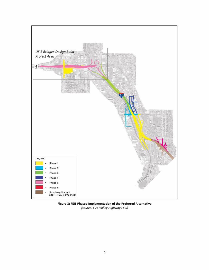
2.3.1 Phasing of the FEIS Preferred Alternative The Project includes elements of two of the six construction phases—Phase 1 and Phase 5—from the Valley Highway Project. A decision on construction Phase 1 of the Valley Highway Project, which included the US 6/Federal Boulevard bridge and ramps, excluding the braided ramp, was made in the 2007 ROD. Figure 3 shows the phases of the Valley Highway Project’s Preferred Alternative and Figure 4 shows the Project Elements and how they relate to the FEIS phasing.
2.3.2 Additional Project Elements in the Project At this time, the Project includes six additional elements that were not included in the FEIS or 2007 ROD:
• Reconstruction of the southbound (SB) I-25 to EB US 6 ramp; • A bicycle/pedestrian bridge structure over US 6, connecting Barnum North and Barnum South
parks; • Replacement of the US 6 bridge over Bryant Street; • Replacement of the US 6 bridge over I-25; • Replacement of the US 6 bridge over the BNSF Railway; and • Pavement resurfacing of US 6 between Sheridan Boulevard and Knox Court
6
Figure 3: FEIS Phased Implementation of the Preferred Alternative
(source: I-25 Valley Highway FEIS)
US 6 Bridges Design Build Project Area
7
Figure 4: Project Elements
8
3. Section 4(f)/Section 6(f) Introduction
3.1 Purpose
The purpose of this technical report is to evaluate the Project to address the following questions:
• Is there a substantive difference in impacts to properties protected under Section 4(f) of the Department of Transportation Act of 1966 (49 United States Code [U.S.C.] 303) and Section 6(f) of the Land and Water Conservation Fund (LWCF) Act of 1965 (16 U.S.C. 4601-04 et seq.) associated with the Preferred Alternative presented in the FEIS and 2007 ROD and the design for the Project?
• Is the Project located within the project footprint that previously received environmental clearances through the FEIS/2007 ROD?
• Is there is a substantive difference between the previous and currently proposed Section 4(f) and Section 6(f) mitigation measures, and are they adequate to offset anticipated uses or conversions, respectively?
A Final Section 4(f) Evaluation was included in the FEIS and 2007 ROD. This appendix to ROD2 provides an update to that Section 4(f) Evaluation and provides a Section 6(f) Evaluation.
4. Section 4(f) Properties The Section 4(f) properties that are park and recreation resources within the Project area are listed in Table 1. All of these facilities are owned and maintained by the City and County of Denver (CCD), and are shown in Figures 5 through 7.
Table 1: Park and Recreation Resources
Park or Recreation Resource
Year Acquired/
Established
Size (acres) Facilities
Barnum Park South 1906 35.6 Basketball court, drinking fountain, flower garden, fishing lake, outdoor swimming pool, playground, picnic tables/shelter, recreation center, restroom, soccer field, tennis court, bike/pedestrian path
Barnum Park North 1937 11.8 Lighted softball fields, bleachers, bike/pedestrian path, bike skills course*
Barnum Park East 1951 13.6 Soccer field, lighted softball field, drinking fountain, restroom
South Platte River Trail 1980 19 miles Paved bike/pedestrian trail
Milstein Park 1980 5.0 Paved bike/pedestrian trail, fishing, picnic tables
Source: CCD, Department of Parks and Recreation, 2003 *This facility was added in the southwest corner of the park after approval of the FEIS and 2007 ROD.
9
Figure 5: Project Area Parkland
10
Figure 6: Barnum Park North Boundaries
11
Figure 7: Parkland Near I-25/US 6 Improvements
12
The FEIS identified direct and indirect uses of all phases of the Preferred Alternative on publicly owned parkland and recreation resources, which are afforded protection under Section 4(f). The FEIS addressed all elements of a Section 4(f) analysis including an evaluation of avoidance alternatives and measures to minimize harm. The avoidance alternatives included widening US 6 without park encroachments and locating the proposed improvements elsewhere in the study area.
The FEIS and 2007 ROD documented Section 4(f) uses in three parks under the Preferred Alternative: Barnum Park South, Barnum Park East, and Barnum Park North. The FEIS concluded that there were no prudent or feasible alternatives to the use of the three aforementioned Section 4(f) properties, and that the Preferred Alternative included all possible planning to minimize harm to these properties. The 2007 ROD reaffirmed FHWA’s FEIS determination.
The Project has Section 4(f) impacts that are different from the FEIS Preferred Alternative because of design refinements made since the FEIS and 2007 ROD. Two parks (Barnum Park North and Barnum Park East) and one historic resource (West and Southside Interceptor Sewer, which is described in Section 4.5) are subject to a Section 4(f) use with implementation of the Project.
Table 2 shows the Section 4(f) uses due to the Project as compared to the Preferred Alternative in the 2007 ROD. The FEIS contains the Section 4(f) Evaluation, but the 2007 ROD clarifies and updates the impacts and mitigation measure for Barnum Park North and Barnum Park East.
Table 2: Section 4(f) Use Comparison
Section 4(f) Resource
Use by 2007 ROD Preferred Alternative
(acres)
Use by Project (acres)
Barnum Park South 0.01 No use (temporary occupancy)
Barnum Park North 0.42 0.63
Barnum Park East 2.1 1.64
Frog Hollow Park No use No use
South Platte River Trail No use (temporary occupancy) No use (temporary occupancy)
Milstein Park Not identified No use
West and Southside Interceptor Sewer
Not identified 240 linear feet
Source: 2007 ROD
4.1 Barnum Park South Impacts The FEIS documented a small (0.01-acre) use of Barnum Park South under the Preferred Alternative due to the Federal Boulevard widening. The current Project has eliminated this impact by modifying the design of the Federal Boulevard interchange. However, there will be a temporary occupancy of the park during construction of the bicycle/pedestrian bridge.
13
4.2 Barnum Park North Impacts In Barnum Park North, the FEIS identified small uses of parkland on the east side of the park (0.02-acre) associated with a redesigned WB on-ramp to US 6 from Federal Boulevard and on the south side of the park (0.03-acre) for the US 6 ramp. The 2007 ROD confirmed the use on the east side of the park, but the use on the south side increased to 0.4-acre. The Project will convert 0.63-acres of Barnum Park North to transportation use as a result of a reconstructed WB Federal Boulevard to US 6 ramp and Federal Boulevard right-of-way (ROW) widening. This impact is shown in Figure 8. In addition to the 0.63-acre use, a 0.27-acre licensed access area associated with the maintenance of a retaining wall along the reconstructed ramp will be required. This area is not considered a use under Section 4(f).
4.3 Barnum Park East Impacts The 2007 ROD documented a 2.1-acre conversion of Barnum Park East to transportation use (this updated what was documented in the FEIS). This would occur on the northern and western park edges due to the widening of Federal Boulevard and the new EB on-ramp from Federal Boulevard to US 6. The Project has less impact (1.64-acres) because the footprint of the US 6/Federal Boulevard interchange has been compressed.
4.4 South Platte River Trail Impacts The 2007 ROD documented a temporary occupancy of the South Platte River Trail during construction activities through detours, though it noted that the trail will ultimately be improved by the project. The 2007 ROD concluded that the temporary construction impacts to the South Platte River Trail would not constitute a use within the meaning of Section 4(f). Those findings are still valid for the Project. There will be a temporary trail detour in place during construction.
4.5 West and Southside Interceptor Sewer Impacts Replacement of the US 6 bridge over the South Platte River will require removal of a segment of the West and Southside Interceptor Sewer, located west of the river. The West and Southside Interceptor Sewer is a Section 4(f) resource because it is a historic resource for which the State Historic Preservation Officer (SHPO) found an adverse effect; this is discussed in more detail in Appendix I of the ROD2. The sewer was not identified as a historic or Section 4(f) resource in the FEIS or 2007 ROD. A segment of the sewer is shown in Figure 9.
A 240-foot portion of the seven-mile-long brick-lined sewer segment needs to be removed because it could sustain damage during construction due to pile driving and drilling. Preservation in place is not prudent due to potential damage. The sewer will be replaced with a new concrete pipe.
For the West and Southside Interceptor, the SHPO determined that the Project met the criteria in order to use the Section 4(f) Evaluation and Approval for Transportation Projects That Have a Net Benefit to a Section 4(f) Property, and that there are no feasible and prudent alternatives to the relocation and reconstruction of the sanitary sewer. The letters between CDOT and SHPO regarding this determination can be found in Appendix B of the ROD2.
14
Figure 8: Barnum Park North Uses
15
Figure 9: West and Southside Interceptor Sewer
16
4.6 Frog Hollow and Milstein Parks Both the FEIS and 2007 ROD indicated there would be no Section 4(f) use of Frog Hollow Park. The same is true for the Project. Neither the FEIS nor the 2007 ROD identified Milstein Park as a Section 4(f) resource. With construction of the Project, there would be no Section 4(f) use of Milstein Park.
4.7 Minimization of Harm to Barnum Park South, Barnum Park North, Barnum Park East, the South Platte River Trail, and the West and Southside Interceptor Sewer
When no prudent and feasible alternative exists, Section 4(f) requires that harm to the protected resources be minimized. During the FEIS and 2007 ROD processes, FHWA and CDOT worked with the CCD to identify appropriate measures to minimize harm. This coordination between the agencies has continued through the Project and ROD2 process, and is discussed in Section 4.8.
Table 3 shows the Section 4(f) mitigation measures for the Project relative to the ones included in the FEIS and 2007 ROD. The Section 4(f) and Section 6(f) mitigation measures proposed for the Project are similar to those cited in the FEIS and 2007 ROD, with additional measures to offset Section 4(f) uses.
Because this is a design build project, the final design and construction of the Project may result in adjustments that affect the area impacted or the improvements proposed within one or more of the park or recreation resource areas. If one of these adjustments is proposed, the design build contractor will need to work with CDOT to secure support from CCD Department of Parks and Recreation and approval from FHWA for any changed impacts and mitigation commitments.
4.7.1 Barnum Park South As shown in Table 3, mitigation for the temporary occupancy of Barnum Park South by the Project will include limiting construction staging within the park limits, replacing landscaping that is damaged as a result of construction activities, and providing on-site public notices of construction activities. These mitigation measures are due to temporary occupancy during construction of the bicycle/pedestrian bridge, and not the result of a Section 4(f) use.
4.7.2 Barnum Park North Specific harm minimization measures from the 2007 ROD for Barnum Park North included:
• North of US 6, move Federal Boulevard widening to the east to avoid Barnum Park North • Relocate bicycle/pedestrian trail in the south part of the park due to the Federal Boulevard to
US 6 on-ramp realignment.
Section 4(f) mitigation for the uses in Barnum Park North includes the construction of a bicycle/pedestrian bridge over US 6 west of Federal Boulevard to improve access between Barnum Park North and Barnum Park South, as shown in Figure 10. This mitigation is more substantial than that documented in the FEIS and 2007 ROD. The ramp connection from this bridge to Barnum Park North will cross over a 0.03-acre area in the easternmost portion of Trestle Bike Skills Course, a new BMX facility that was installed after the FEIS and 2007 ROD were approved, connecting to existing bicycle/pedestrian paths in the park. The northern landing of the bridge will not impact the function of the course, but will require sidewalk reconfiguration by the contractor to provide connectivity commensurate with existing conditions. The relocation of the hiking/bike trail along the south side of the park was included in the 2007 ROD as mitigation.
17
Table 3: Section 4(f) Mitigation Comparison
Section 4(f) Resource
Mitigation from Valley Highway Project FEIS/ROD
Mitigation for Project
All resources within Project limits
N/A CDOT will be immediately notified for any Section 4(f) impacts greater than those anticipated in ROD2. If additional impacts than those already anticipated cannot be avoided, the Contractor will be responsible for all coordination and mitigation measures.
Barnum Park South*
Minimize acquisition by shifting Federal Boulevard widening to the east
• Ensure that all environmentally sensitive areas have clearly labeled "No Parking and No Staging Areas" on the final plan sheets
• Replace landscaping that is damaged as a result of construction activities
• Provide on-site public notices of construction activities
Barnum Park North North of US 6, move Federal Boulevard widening to the east to avoid Barnum Park North.
• For any new or additional impacts, minimize acquisition by shifting Federal Boulevard widening to the east to avoid additional impacts to Barnum Park North.
• Construction of a bicycle/pedestrian bridge over US 6 to connect Barnum Park North and Barnum Park South
Relocate bicycle/pedestrian trail along the south side of the park
• Relocate trail north of its current location; replace fencing, turf and irrigation system; and provide all CDOT commitments included in the IGA with Denver Department of Parks and Recreation.
• Reconfigure the trail near the tie-in to the new bicycle/pedestrian bridge landing to maintain existing and provide for new connectivity
Barnum Park East Minimize size of interchange and ROW acquisition
Limit use to 1.64-acres
CDOT to financially compensate CCD for ROW acquisition. Comply with the 2007 intergovernmental agreement (IGA) between CDOT and CCD detailing the in-kind replacement of Barnum Park East facilities.
Comply with 2012 IGA between CDOT and CCD
Provide additional, new parkland along the east edge of the park by vacating the existing on-ramp to US 6 and acquiring a strip of land from an adjacent property owner. Add 0.5-acres to the east edge of the park.
Provide additional, new parkland along the east edge of the park by vacating the existing on-ramp to US 6 and acquiring a strip of land from an adjacent property owner. Add 0.4-acres to the east end of the park.*
18
Section 4(f) Resource
Mitigation from Valley Highway Project FEIS/ROD
Mitigation for Project
Barnum Park East (continued)
CCD to make arrangements to provide alternative play locations from permitted field users during seasons that will be disrupted by construction; CDOT to financially compensate CCD for costs associated with this effort.
CCD to make arrangements to provide alternative play locations from permitted field users during seasons that will be disrupted by construction; CDOT to financially compensate CCD for costs associated with this effort.
South Platte River Trail**
Provide detour for trail users Contractor to provide mitigation during construction as defined in Book 2 Section 16.2.8 (Trail and Pedestrian Impacts) for the temporary use of the South Platte River Trail: • Existing trail systems, temporary trails,
sidewalks, and pedestrian routes must be maintained at all times. An approved detour is included in Book 2 Section 16.2.8.
• The Contractor shall meet all requirements of the Americans with Disabilities Act.
• No trail closures shall be allowed from 5:00 a.m. to 8:00 p.m. any day of the week.
• Temporary trail detours will be allowed under the following conditions: Public Information Plan requirements shall be identified and appropriate public notifications provided; the Contractor shall comply with the CDOT Construction Detour Standards for Multi-Use Trails.
West and Southside Interceptor Sewer
Not identified
• Interagency PA on Denver brick-lined sewers***
• CDOT to develop an in-depth report on the history of the development of Denver’s brick-lined sewers****
*Though the 0.4-acres being added to the east end of the park is less than 0.5 identified in the FEIS/2007 ROD, the Federal Boulevard interchange footprint has been reduced (from 2.1-acres to 1.64-acres) and less parkland is being acquired by the Project compared to the FEIS/2007 ROD Preferred Alternative. **No Section 4(f) use, but mitigation measure has been agreed upon by CDOT and CCD for temporary occupancy. ***Mitigation identified as part of the cultural resources (Section 106) consultation; is also being used as Section 4(f) mitigation. **** Mitigation identified as part of the cultural resources (Section 106) consultation; is also being used as Section 4(f) mitigation. An initial report has already been developed.
19
Figure 10: Barnum Park North Section 4(f) Mitigation
4.7.3 Barnum Park East Specific harm minimization measures from the 2007 ROD for Barnum Park East include:
• Minimize intersection spacing on Federal Boulevard at the US 6 ramp terminals to minimize size of interchange
• CDOT to financially compensate CCD for ROW acquisition. Comply with the IGA between CDOT and CCD detailing the in-kind replacement of Barnum Park East facilities.
• Provide additional, new parkland along the east edge of the park by vacating the existing on-ramp to US 6 and acquiring a strip of land from an adjacent property owner.
• CCD to make arrangements to provide alternative play locations from permitted field users during seasons that will be disrupted by construction; CDOT to financially compensate CCD for costs associated with this effort.
In Barnum Park East, the Project provides similar mitigation as had been planned for the Valley Highway Project, but it would add 0.4-acre to the east end of the park, as shown in Figure 11.
20
Figure 11: Barnum Park East Section 4(f) Mitigation
4.7.4 South Platte River Trail As shown in Table 3, mitigation for the temporary use of the South Platte River Trail by both projects would include providing detours, minimizing closure times, and providing public notices in advance of any closures.
4.7.5 West and Southside Interceptor Sewer In the FEIS and 2007 ROD, no measures were included for the West and Southside Interceptor Sewer because it was not identified as a Section 4(f) resource.
A specific harm minimization measure for the Project includes limiting the length of the brick-lined sewer destruction and relocation to a 240-foot-long segment under the new US 6 bridge over the South Platte River. Section 4(f) mitigation for the use of the West and Southside Interceptor Sewer includes:
• CDOT to develop an in-depth report on the history of the development of Denver’s brick-lined sewers
• CDOT to develop a city-wide PA between CDOT, FHWA, SHPO, CCD, and Metro Wastewater regarding Denver's brick-lined sewers
21
• For the West and Southside Interceptor Sewer, CDOT developed a project specific Section 4(f) Net Benefits Programmatic, which documents FHWA’s finding that the use of the Net Benefits nationwide programmatic is appropriate for the Section 4(f) evaluation for this property for this Project. The project specific programmatic can be found in Appendix B of ROD2.
4.8 Coordination Coordination has been conducted with agencies having jurisdiction or regulatory oversight of Section 4(f) properties. Coordination efforts build upon the FEIS coordination, and to date have included:
• Consultation and coordination with the SHPO for cultural resources and historic sites including the West and Southside Interceptor Sewer.
• Coordination with the CCD Parks and Recreation Department and the Department of Public Works concerning the impacts and mitigation for Section 4(f) resources.
• Completion of an IGA between CDOT and CCD. This IGA will include roles and responsibilities of CDOT and CCD, details and requirements of Section 4(f) and Section 6(f) mitigation, and design requirements for Barnum Park East, Barnum Park North, and the bicycle/pedestrian bridge.
• Completion of a PA between CDOT, FHWA, SHPO, CCD, and Metro Wastewater regarding Denver’s brick-lined sewers. The PA has been initiated, but not completed.
4.9 Section 4(f) Finding At the time of the FEIS, FHWA found that there were no prudent and feasible alternatives that met the purpose and need of the project and avoided the use of Barnum Park North and Barnum Park East. Because the impacts of the Project are within the same general footprint and of the same general scale as the FEIS Preferred Alternative and 2007 ROD Selected Alternative, these findings are still valid. For the West and Southside Interceptor Sewer, the SHPO determined that the Project met the criteria in order to use the Section 4(f) Evaluation and Approval for Transportation Projects That Have a Net Benefit to a Section 4(f) Property and that there are no feasible and prudent alternatives to the relocation and reconstruction of the sanitary sewer. FHWA also finds that there are no prudent and feasible alternatives to the use of the West and Southside Interceptor Sewer, and the Project includes all possible planning to minimize harm resulting from such use. The project specific Section 4(f) Net Benefits Programmatic documents FHWA’s finding that the use of the Net Benefits nationwide programmatic is appropriate for the Section 4(f) evaluation for this property for this Project.
22
5. Section 6(f) Properties There are three Section 6(f) properties in the Project area, according to information provided by Colorado Parks and Wildlife (State Parks). They include:
1. Barnum Park North 2. Barnum Park South 3. South Platte River Greenway, which contains three features in the Project area: Frog Hollow
Park, the South Platte River Trail, and Milstein Park
Improvements made with the LWCF are protected under Section 6(f) of the Act from conversion to uses other than public outdoor recreation without appropriate mitigation.
The FEIS documented no Section 6(f) conversions under the Preferred Alternative. The current Project has 6(f) impacts that are different from the FEIS Preferred Alternative because of design refinements made since the FEIS and 2007 ROD. One park (Barnum Park North) is subject to a Section 6(f) conversion with implementation of the Project. One recreation area (the South Platte River Greenway, which includes the South Platte River Trail) is subject to a temporary impact during construction activities.
According to information provided by State Parks, the Section 6(f) improvements that were made at Barnum Park South were confined to the southeastern portion of the park, which is outside of the Project area. No grants from the LWCF have been used in Barnum Park East. Thus, no conversion of such resources would occur.
5.1 Barnum Park North Description and Impacts Barnum Park North was previously described in Section 3.5. This park contains improvements made with LWCF grants. Section 6(f) improvements were made at Barnum North Park in 1973 and 1976.
Construction of the new WB on-ramp at Federal Boulevard will result in a 0.63-acre encroachment into Barnum Park North, and constitutes a Section 6(f) resource conversion to a transportation facility. Figure 8 shows the area to be converted. This conversion would cover the same area that is being documented as a Section 4(f) use. This conversion will impact the existing bicycle/pedestrian trail, currently located in CDOT ROW.
5.2 South Platte River Greenway Description and Impacts A portion of the South Platte River floodplain contains improvements made with LWCF grants. This area is called the South Platte River Greenway, and it includes Denver-owned lands in the floodplain, according to information provided by State Parks. The Section 6(f) boundary associated with the South Platte River Greenway is shown in Figure 12.
At this time, there is no assumed need for conversion of the South Platte River Greenway; however, because this Project will be constructed as a design/build project, it is possible that the final design may include a small conversion such as new bridge piers or water quality structures. As such, CDOT is working on the assumption that as much as five acres (but likely much less) may be converted from the South Platte River Greenway. A Section 6(f) conversion less than five acres is considered a de minimis conversion.
23
Figure 12: South Platte River Greenway Boundary
The South Platte River Trail, which extends 19 miles north and south of US 6 within the South Platte River Greenway, is a bicycle and pedestrian trail along the river, as shown in Figure 13. Replacing the US 6 bridge over the South Platte River and I-25 will not result in the conversion of this recreational facility to transportation use, but will require temporary closures and detours during bridge and ramp construction.
Table 4 shows the Section 6(f) conversions due to the Project as compared to the Preferred Alternative in the FEIS and 2007 ROD.
24
Figure 13: Project Improvements at I-25/US 6 Interchange and South Platte River Trail
Table 4: Section 6(f) Conversion Comparison
Section 6(f) Resource Conversion of Valley Highway Project FEIS/ROD Preferred
Alternative (acres)
Conversion of Proposed Project (acres)
Barnum Park South No conversion; Section 6(f) resources are located on opposite side of park, away from US 6 improvements
No conversion; Section 6(f) resources are located on opposite side of park, away from US 6 improvements
Barnum Park North No conversion 0.63
South Platte River Greenway
No conversion Up to five acres, to be determined by the design/build contractor
Source: FEIS (2006)
25
5.3 Minimization of Harm to Barnum Park North and the South Platte River Greenway
Table 5 summarizes the mitigation measures for Barnum Park North and the South Platte River Greenway as a result of Section 6(f) conversions, comparing the mitigation to what was documented in the FEIS and 2007 ROD.
Table 5: Section 6(f) Mitigation Comparison
Section 6(f) Resource Mitigation from Valley Highway Project FEIS/ROD
Mitigation for Project
All resources within Project limits
N/A CDOT will be immediately notified for any Section 6(f) impacts greater than those anticipated in ROD2. If additional impacts than those already anticipated cannot be avoided, the Contractor will be responsible for all coordination and mitigation measures. CDOT and CPW to continue coordination with NPS to obtain approval for the Section 6(f) conversions and mitigations. CPW to submit official conversion request to NPS during construction, but after all impacts are known and finalized and the value of the land is assessed.
Barnum Park North Not identified Acquire additional parkland to offset land conversion
South Platte River Greenway
Not identified Keep an accurate and detailed record of all impacts to the South Platte River Greenway. These records need to include square footage of the impacts and the value of that land. The Contractor will be required to furnish these records when requested so that CDOT can provide them to CCD, Colorado Parks and Wildlife (CPW) and the National Park Service (NPS) once all impacts are known. If less than or equal to five acres of Section 6(f) land is converted, CDOT to assure that there is an equal value exchange. If greater than five acres is converted, CDOT shall reopen coordination with State Parks to determine next steps.
Source: FEIS (2007)
26
5.3.1 Barnum Park North The mitigation for the potential 0.63-acre Section 6(f) conversion at Barnum Park North will be land-for-land replacement at a minimum one-to-one ratio in square footage and value. The replacement land will potentially come from several parcels that are being acquired by the Project and will be converted to parkland totaling 0.94-acre. These include, but are not limited to, 720 square feet (SF) adjacent to 5th Avenue east of Federal Boulevard (parcels 206-210), 18,227 SF adjacent to Barnum Park East (parcel 212c), and 22,090 SF along the South Platte River adjacent to Frog Hollow Park that is privately owned (parcel 225). Figure 14 shows these parcels. The official conversion request will occur post-construction when the value of the land will be assessed prior to the NPS final approval. There will be an equal value exchange for all Section 6(f) properties acquired.
In addition, the trail in Barnum Park North that is located along the south side of the park will be relocated out of the impacted area and the landscaping and irrigation along this trail will be reinstalled.
5.3.2 South Platte River Greenway CDOT will assure that there is an equal value exchange for any Section 6(f) property acquired. The fair market valuation of the replacement land will exceed the fair market value of the lands acquired as determined by the application of the Uniform Relocation Assistance and Real Property Acquisition Policies Act of 1970. If there is the potential for greater than five acres of conversion as the design progresses, CDOT will reopen coordination with State Parks to determine appropriate next steps.
Temporary occupancy of the South Platte River Trail would be adequately mitigated by the same means described earlier for Section 4(f) mitigation.
27
Figure 14: Parcels to be Converted to Parkland as Section 6(f) Mitigation
28
5.4 Coordination Coordination has occurred with agencies having jurisdiction or regulatory oversight of Section 6(f) properties. Coordination to date has included:
• A scoping meeting with State Parks staff on May 11, 2012 to discuss the Section 6(f) properties and boundaries within the Project area. During this meeting, CDOT obtained information about Section 6(f) improvements to specific parks as well as the process for mitigating impacts to parks with Section 6(f) improvements.
• Letters of coordination between CDOT, CCD, State Parks, and the NPS concerning Section 6(f) impacts and mitigation measures. All agencies have indicated support for the project and have agreed to the proposed mitigation measures. The coordination letters can be found in Appendix B of ROD2.
• State Parks has begun the consultation process with the NPS for conversion of Barnum Park North and the South Platte River Greenway. State Parks sent a letter to NPS in August 2012 requesting conversion of Barnum Park North and requesting their acceptance of mitigation measures for Barnum Park North and the South Platte River Trail. These mitigation measures included the new bicycle/pedestrian bridge connecting Barnum Park North and South, which is also included as Section 4(f) mitigation. NPS responded with the requirement that Section 6(f) conversions must be mitigated with a replacement of land-for-land at a one-to-one ratio and equivalent value, and that the new bridge could not count as mitigation.
• CDOT sent a revised letter to State Parks on November 6, 2012 requesting approval to convert Section 6(f) assisted land within Barnum Park North for the Project, and requesting acceptance of the revised mitigation measures that have been proposed for Barnum Park North and the South Platte River Trail. The mitigation measures were modified since the August 2012 correspondence to include a land-for-land replacement at a one-to-one ratio and equivalent value. State Parks coordinated with NPS on the revised mitigation. NPS responded via telephone call to State Parks on November, 19, 2012 indicating agreement in concept with the mitigation approach. This documented conversation can be found in Appendix B of ROD2.
• Per NPS request, after construction of the Project, the value of land will be assessed and an official Section 6(f) conversion request will be made to NPS.
5.5 Section 6(f) Conclusion Table 6 summarizes the conversions associated with the Project elements and the total acres of land proposed as mitigation.
Table 6: Summary of Section 6(f) Conversions
Project Element Section 6(f) Site Acres of
Conversion
US 6/Federal Boulevard Interchange Barnum Park North 0.63
I-25/US 6 Interchange: Bridge and Ramp Improvements South Platte River Greenway <5
Total 0.63 – 5.62
29
CDOT will assure that the mitigation plan for the project will include replacement of land-for-land at a one-to-one ration and equivalent value. The official conversion request will occur post-construction when the value of the land will be assessed prior to NPS final approval. There will be an equal value exchange for all Section 6(f) properties acquired. Such exchange will be valued according to the requirements of the Uniform Relocation Assistance and Real Property Acquisition Policies Act of 1970 for both the property acquired and for any properties used as part of the payment. In all situations where the valuation of the property acquired exceeds the value of the property to be used as payment, the difference shall be paid as cash, and that cash shall be used in a manner consistent with Section 6(f) principles. Appraisals are conducted as part of CDOT’s ROW process, which occurs once design is more complete and project funds have been identified.
Because this is a design/build project, the final design and construction of the Project may result in adjustments that affect the area impacted or the improvements proposed within one or more of the park or recreation resource areas, including the South Platte River Greenway. If one of these adjustments is proposed, the design build contractor will be required to work with CDOT to secure support from CCD Department of Parks and Recreation and approval from FHWA and/or NPS for any changed impacts and mitigation commitments.
6. References City and County of Denver. Denver Parks & Recreation. Concurrence with Mitigation Measures Pertaining to the Conversion of Section 6(f) Assisted Properties at Barnum Park North, and the Temporary Closure of the South Platte River Trail for the Proposed US 6 Bridges Design Build Project, Denver Colorado. August 6, 2012.
City and County of Denver. Denver Parks & Recreation. Concurrence with Mitigation Measures Pertaining to the Use of Section 4(f) Protected Properties at Barnum Park North and Barnum Park East, and the Temporary Occupancy of Barnum Park South and the South Platte River Trail for the Proposed US 6 Bridges Design Build Project, Denver, Colorado. December 6, 2012.
City and County of Denver. Denver Parks & Recreation. Concurrence with Mitigation Measures Pertaining to the Conversion of Section 6(f) Assisted Properties at Barnum Park North and the Temporary Closure of the South Platte River Trail for the Proposed US 6 Bridges Design Build Project, Denver Colorado. November 20, 2012.
Colorado Department of Transportation. November 2006. Final Environmental Impact Statement/Final Section 4(f) Evaluation: I-25 Valley Highway Project, Logan to US 6.
Colorado Department of Transportation. Request for Concurrence with Mitigation Measures Pertaining to the Use of Section 4(f) Protected Properties and the Conversion of Section 6(f) Assisted Properties at Barnum Park North, Barnum Park East, and the South Platte River Trail for the Proposed US 6 Bridges Design Build Project, Denver Colorado. July 20, 2012.
Colorado Department of Transportation. Section 106 Determinations of Effect within the 6th Avenue Corridor of the I-25 Valley Highway Environmental Impact Statement Project (CDOT Subaccount Nos. 18838, 18202, and 18192 [overall project number]; CHS # 40477); Notification of Section 4(f) net benefits evaluation and request for SHPO comment. August 2, 2012.
Colorado Department of Transportation. Request for Permission to Convert One Property Funded with Land and Water Conservation Funds to a Transportation Use in Denver, Colorado: Barnum Park North; and Request for Permission for Temporary Transportation Use of One Property Funded with Land and Water Conservation Funds in Denver, Colorado: South Platte River Trail. August 10, 2012.
Colorado Department of Transportation. Request for Permission to Convert One Property Funded with Land and Water Conservation Funds to a Transportation Use in Denver, Colorado: Barnum Park North; and Request for Permission for Temporary Transportation Use of One Property Funded with Land and Water Conservation Funds in Denver, Colorado: South Platte River Trail. November 6, 2012.
Colorado Department of Transportation. Section 4(f) Net Benefits Programmatic for the Adverse Effect to the Historic Brick-Lined Sewer due to the US 6 Bridges Design Build Project (CDOT Subaccount Number 18838). January 24, 2013.
Federal Highway Administration. July 2007. Record of Decision: I-25 Valley Highway Project, Logan to US 6.
Personal communication: Troy Halouska, CDOT (July 13, 2012), indicated no new right of way is needed from Barnum Park south.
Personal communication: Troy Halouska, CDOT (August 3, 2012), provided information regarding the Section 4(f)/Section 6(f) technical Report.Personal communication: Thomas M. Morrissey, PE, State Trails, Program Manager, Colorado Parks and Wildlife (November 15, 2012) request for tentative concurrence from both State of Colorado and National Parks Service to proceed with plans to bid and initiate construction.