SECTION 5.4.4: RISK ASSESSMENT – GROUND FAILURE DMA 2000 Hazard Mitigation Plan – Onondaga County, New York 5.4.4-1 April 2010 5.4.4 GROUND FAILURE This section provides a profile and vulnerability assessment for the ground failure hazard. HAZARD PROFILE This section provides profile information including description, extent, location, previous occurrences and losses and the probability of future occurrences. Description According to the U.S. Geological Survey (USGS), “ground failure” is the term used to describe zones of ground cracking, fissuring, and localized horizontal and vertical permanent ground displacement that can form by a variety of mechanisms on gently sloping valley floors. Ground failure may be caused by surface rupture along faults, secondary movement on shallow faults, shaking-induced compaction of natural deposits in sedimentary basins and river valleys, and liquefaction of loose, sandy sediment (USGS, 2005). For the purpose of this HMP, the ground failure hazard includes, but is not limited to, landslides, land subsidence, erosion, debris flows and sinkholes, which are further defined as follows: Landslide : Landslides are a type of slope failure, resulting in a downward and outward movement of rock, debris or soil down a slope under the force of gravity (New York State Disaster Preparedness Commission [NYSDPC], 2008). They are one of the forms of erosion called mass wasting, which is broadly defined as erosion involving gravity as the agent causing movement. Because gravity constantly acts on a slope, landslides only occur when the stress produced by the force of the gravity exceeds the resistance of the material (Organization of American States [OAS], 1991). Landslides consist of free-falling material from cliffs, broken or unbroken masses sliding down mountains or hillsides, or fluid flows. Materials can move up to 120 miles per hour (mph) or more, and slides can last a few seconds or a few minutes, or can be gradual, slower movements over several hours or days. There are several different types of landslides including: • Rock Falls are when a mass detaches from a steep slope or cliff and descends by free-fall, bounding, or rolling. • Rock Topples are a mass tilts or rotates forward as a unit. • Slides area mass displaces on one or more recognizable surfaces, which may be curved or planar. • Flows are a mass moves downslope with a fluid motion. A significant amount of water may or may not be part of the mass (OAS, 1991). Landslides can occur naturally or be triggered by human-related activities. Naturally-occurring landslides can occur on any terrain, given the right condition of soil, moisture, and the slope’s angle. They are caused from an inherent weakness or instability in the rock or soil combined with one or more triggering events, such as heavy rain, rapid snow melt, flooding, earthquakes, vibrations and other natural causes. Other natural triggers include the removal of lateral support through the erosive power of streams, glaciers, waves, and longshore and tidal currents; through weathering, and wetting, drying and freeze-thaw cycles in surficial materials; or through land subsidence or faulting that creates new slopes (International Union of Geological Sciences [IUGS], Date Unknown). Long-term climate change can influence landslide occurrences through increased precipitation, ground
Transcript
SECTION 5.4.4: RISK ASSESSMENT – GROUND FAILURE
DMA 2000 Hazard Mitigation Plan – Onondaga County, New York 5.4.4-1 April 2010
5.4.4 GROUND FAILURE
This section provides a profile and vulnerability assessment for the ground failure hazard.
HAZARD PROFILE
This section provides profile information including description, extent, location, previous occurrences and losses and the probability of future occurrences.
Description According to the U.S. Geological Survey (USGS), “ground failure” is the term used to describe zones of ground cracking, fissuring, and localized horizontal and vertical permanent ground displacement that can form by a variety of mechanisms on gently sloping valley floors. Ground failure may be caused by surface rupture along faults, secondary movement on shallow faults, shaking-induced compaction of natural deposits in sedimentary basins and river valleys, and liquefaction of loose, sandy sediment (USGS, 2005). For the purpose of this HMP, the ground failure hazard includes, but is not limited to, landslides, land subsidence, erosion, debris flows and sinkholes, which are further defined as follows:
Landslide: Landslides are a type of slope failure, resulting in a downward and outward movement of rock, debris or soil down a slope under the force of gravity (New York State Disaster Preparedness Commission [NYSDPC], 2008). They are one of the forms of erosion called mass wasting, which is broadly defined as erosion involving gravity as the agent causing movement. Because gravity constantly acts on a slope, landslides only occur when the stress produced by the force of the gravity exceeds the resistance of the material (Organization of American States [OAS], 1991). Landslides consist of free-falling material from cliffs, broken or unbroken masses sliding down mountains or hillsides, or fluid flows. Materials can move up to 120 miles per hour (mph) or more, and slides can last a few seconds or a few minutes, or can be gradual, slower movements over several hours or days. There are several different types of landslides including:
• Rock Falls are when a mass detaches from a steep slope or cliff and descends by free-fall, bounding, or rolling.
• Rock Topples are a mass tilts or rotates forward as a unit.
• Slides area mass displaces on one or more recognizable surfaces, which may be curved or planar.
• Flows are a mass moves downslope with a fluid motion. A significant amount of water may or may not be part of the mass (OAS, 1991).
Landslides can occur naturally or be triggered by human-related activities. Naturally-occurring landslides can occur on any terrain, given the right condition of soil, moisture, and the slope’s angle. They are caused from an inherent weakness or instability in the rock or soil combined with one or more triggering events, such as heavy rain, rapid snow melt, flooding, earthquakes, vibrations and other natural causes. Other natural triggers include the removal of lateral support through the erosive power of streams, glaciers, waves, and longshore and tidal currents; through weathering, and wetting, drying and freeze-thaw cycles in surficial materials; or through land subsidence or faulting that creates new slopes (International Union of Geological Sciences [IUGS], Date Unknown). Long-term climate change can influence landslide occurrences through increased precipitation, ground
SECTION 5.4.4: RISK ASSESSMENT – GROUND FAILURE
DMA 2000 Hazard Mitigation Plan – Onondaga County, New York 5.4.4-2 April 2010
saturation, and a rise in groundwater level, which reduces the strength and increases the weight of the soil (City of Homer, 2004; U.S. Search and Rescue Task Force [USSARTF], 2007]; USGS, 2005). Landslides can also be induced, accelerated or retarded by human actions. Human-related causes of landslides can include grading, terrain/slope cutting and filling, quarrying, removal of retaining walls, lowering of reservoirs, vibrations from explosions, machinery, road and air traffic and excessive development. Normally stable slopes can fail if disturbed by development activities. Often, a slope can also become unstable by earthmoving, landscaping, or vegetation clearing activities (New Jersey Office of Emergency Management [NJOEM], 2005; IUGS, Date Unknown). Changing drainage patterns, groundwater level, slope and surface water through agricultural or landscape irrigation, roof downspouts, septic-tank effluent or broken water or sewer lines can also generate landslides (City of Homer, 2004; USSARTF, 2007). Due to the geophysical or human factors that can induce a landslide event; they can occur in developed areas, undeveloped areas, or any areas where the terrain was altered for roads, houses, utilities, buildings, and even for lawns in one’s backyard. Landslides occur in all fifty states with varying frequency. More than half the states have rates sufficient to be classified as a significant natural hazard (American Planning Association, 2007). Depending on where the landslides occur, they can pose significant risks to health and safety or interruption to transportation and other services (Northern Virginia Regional Commission [NVRC], 2006; NYSDPC, 2008). Land Subsidence: Land subsidence can be defined as the sudden sinking or gradual downward settling of the earth’s surface with little or no horizontal motion, owing to the subsurface movement of earth materials (NYSDPC, 2008; USGS, 2007). Subsidence often occurs through the loss of subsurface support in Karst terrain, which may result from a number of natural and human-caused occurrences. Karst is a distinctive topography in which the landscape is largely shaped by the dissolving action of water on carbonate bedrock (usually limestone, dolomite, or marble) (NYSDPC, 2008). In Karst areas, water enriched with carbon dioxide flows along natural bedrock fractures and can slowly dissolve the bedrock to create solution-widened pathways. In time, small cavities in the bedrock can become small caverns, and if the caverns become large enough, and the overlying weight of soil and bedrock is great enough, collapse can occur which may involve the land surface, often causing serious damage to buildings or roads (Kappel, 2009; Federal Institute of Geosciences and Natural Resources (BGR), Date Unknown). Subsidence is caused by either human actions, alterations to the surface and underground hydrology or natural geologic processes. Such causes include: underground mining of coal, metallic ores, limestone, salt, and sulfur; withdrawal of groundwater, petroleum, and geothermal fluids from underground reservoirs or certain types of rock (evaporite rock [salt and gypsum], or carbonate rock [limestone and dolomite]); collapse of underground mines; dewatering or drainage of organic soils; pumping of groundwater from limestone (sinkholes); wetting of dry, low-density soil (hydrocompaction); natural sediment compaction; melting of permafrost; liquefaction; and crustal deformation. Resource and land development practices, mainly underground mining, groundwater and petroleum withdrawal, and the drainage of organic soil, are key contributors to the problem of subsidence (USGS, 2006). More than 80-percent of the identified subsidence in the U.S. is a consequence of human exploitation of underground water, and the increasing development of land and water resources threatens to exacerbate existing land-subsidence problems and initiate new ones (USGS, 2007). Mudboils or Mud Volcanoes: Another, less common cause of land subsidence is a natural phenomenon known as mudboils. Mudboils are volcano-like cones of fine sand and silt that range from several inches to several feet high and from several inches to more than 30 feet in diameter.
SECTION 5.4.4: RISK ASSESSMENT – GROUND FAILURE
DMA 2000 Hazard Mitigation Plan – Onondaga County, New York 5.4.4-3 April 2010
Active mudboils are dynamic ebb-and-flow features that can erupt and form a large cone in several days, then cease flowing, or they may discharge continuously for several years. Mudboils continuously discharge sediment-laden (turbid) water, pulling sediments from the subsurface, which can lead to gradual land subsidence (Kappel and McPherson, 1998; Kappel et al., 1996). Land subsidence is one of the most varied forms of ground failure affecting the U.S., ranging from broad regional lowering of land surfaces to local collapses. Regional lowering may aggravate the flood potential or permanently inundate an area, particularly in coastal or riverine settings. Local collapse may damage or destroy buildings, roads, and utilities (Federal Emergency Management Agency [FEMA], 1997; National Research Council Commission on Engineering and Technical Systems, 1991). Other impacts of subsidence include, but are not limited to changes in elevation and slope of streams, canals, and drains; damage to bridges, roads, railroads, storm drains, sanitary sewers, canals, and levees; damage to private and public buildings; and failure of well casings from forces generated by compaction of fine-grained materials in aquifer systems. In some coastal areas, subsidence has resulted in tides moving into low-lying areas that were once above high-tide levels (Leake, 2004). Typically, land subsidence poses a greater risk to property than to human life. The average annual damage throughout the U.S. from all types of subsidence is estimated to be at least $125 million. Damage consists primarily of direct structural damage and property loss and depreciation of land values. It also includes business and personal losses that accrue during periods of repair (FEMA, 1997). Erosion: Erosion is the gradual breakdown and movement of land, due to both physical and chemical processes of water, wind, and general meteorological conditions. Natural (geologic) erosion has occurred since the Earth’s formation and continues each year at a very slow and uniform rate. There are two types of soil erosion: wind erosion and water erosion. Wind erosion can cause significant soil loss. Winds blowing across sparsely vegetated or disturbed land can pick up soil particles and carry them through the air, causing the soil to be displaced. Water erosion can occur over land or in streams and channels. Water erosion that takes place on land can be caused by rain, shallow sheets of water flowing off the land, or shallow surface flow. Stream channel erosion may occur as the volume and velocity of water flow increases enough to cause movement of the streambed and bank soils (NVRC, 2006). Debris Flows: Debris flows, sometimes referred to as mudslides, mudflows, lahars, or debris avalanches, are common types of rapidly-moving landslides. They are flowing rivers of rock, earth, and other water-saturated debris that develop when water rapidly accumulates in the ground, during heavy rainfall or rapid snowfall (Federal Emergency Management Agency [FEMA], 2006). Debris flows generally start on steep hillsides as shallow landslides that liquefy and accelerate to speeds that are typically around 10 miles per hour, but can exceed 35 miles per hour. As they continue to flow down hills and through channels, they grow in volume with the addition of water, sand, mud, boulders, trees, and other materials (National Disaster Education Coalition, Date Unknown). Sinkholes: Sinkholes are a natural and common geologic feature in areas with underlying limestone, carbonate rock, salt beds, or other rocks that are soluble in water. As the rock dissolves, spaces and caverns develop underground. The land usually stays intact until the underground cavities become too large. If there is not enough support for the land above these voids, a sudden collapse of overlying sediments can occur, creating a sinkhole (USGS, 2008). There are three general types of sinkholes: collapse, solution and subsidence. Collapse sinkholes are the most common in areas where the overburden is thick with soils and heavy clay. This type can
SECTION 5.4.4: RISK ASSESSMENT – GROUND FAILURE
DMA 2000 Hazard Mitigation Plan – Onondaga County, New York 5.4.4-4 April 2010
form with little warning and leave behind a deep, steep-sided hole (Cervone, 2003). Solution sinkholes form where no overburden is present and the limestone is exposed at land surface (NVRC, 2006). A bowl-shaped depression (solution sinkhole) forms slowly and continuously as chemical and physical processes dissolve and erode the rock respectively, usually where the overburden soil is thin. The limestone is slowly dissolved and creates a depression in the land surface which is filled with sediment carried into it. Water in the depression either evaporates and/or flows out through the bottom of the depression, usually flowing into a natural fracture. As the sediment continues to accumulate, the discharge of water from the bottom of the depression may cease as the bedrock fracture becomes clogged with sediment and other organic debris. Water many then accumulate and a pond or lake can form (Cervone, 2003). Sinkholes can form without warning. Slumping or falling fence posts, trees, or foundations; sudden formation of small ponds; wilting vegetation; discolored well water; and/or structural cracks in walls and floors, are all specific signs that a sinkhole is forming. They can form into steep-walled holes to bowl or cone shaped depressions. Sinkholes can also be triggered by human activities, including: over-withdrawal of groundwater, diverting surface water from a large area and concentrating it in a single point, artificially creating ponds of surface water, and drilling new water wells. In urban and suburban areas, sinkholes can destroy highways and buildings (St. John’s River Water Management District, 2003).
These types of ground failures, particularly landslides and land subsidence, impose many direct and indirect costs on a community. Direct costs include the actual damage sustained by buildings and property. Indirect costs are harder to measure and include business disruption, loss of tax revenues, reduced property values, loss of productivity, losses in tourism, and losses from litigation. They have a significant adverse effect on infrastructure and threaten transportation corridors, fuel and energy conduits, and communications linkages. Ground failure events have devastating economic effects on Federal, State, local, and private roads, bridges, and tunnels every year. Railroads, pipelines, electric and telecommunication lines, dams, offshore oil and gas production facilities, port facilities, and waste repositories are continually affected by land movement. Road building and construction often exacerbate the landslide problem in hilly areas by altering the landscape, slopes, and drainages and by changing runoff directions and causing channeling, thereby increasing the potential for landslides. Landslides and others forms of ground failure also have adverse environmental consequences, such as dramatically increased soil erosion, siltation of streams and reservoirs, blockage of stream drainages, and loss of valuable watershed, grazing, and timber lands (Spiker and Gori, 2000). Historic records indicate Onondaga County has been impacted by ground failure, more specifically landslide and land subsidence, in the past. The County is still vulnerable to this natural hazard. For the purpose of this HMP, only these two types of ground failure, landslide and land subsidence, will be discussed in more detail. Few incidences of other types of ground failures were found; therefore, no further assessments of erosion, mudslides and sinkholes were deemed necessary, unless they are linked with a landslide or land susceptibility incident.
Extent Landslide To determine the extent of a landslide hazard, the affected areas need to be identified and the probability of the landslide occurring within some time period needs to be assessed. Natural variables that contribute to the overall extent of potential landslide activity in any particular area include soil properties, topographic position and slope, and historical incidence. Predicting a landslide is difficult, even under
SECTION 5.4.4: RISK ASSESSMENT – GROUND FAILURE
DMA 2000 Hazard Mitigation Plan – Onondaga County, New York 5.4.4-5 April 2010
ideal conditions. As a result, the landslide hazard is often represented by landslide incidence and/or susceptibility, defined below:
• Landslide incidence is the number of landslides that have occurred in a given geographic area. High incidence means greater than 15-percent of a given area has been involved in landsliding; medium incidence means that 1.5 to 15-percent of an area has been involved; and low incidence means that less than 1.5-percent of an area has been involved. (Geological Hazards Program, Date Unknown).
• Landslide susceptibility is defined as the probable degree of response of geologic formations to natural or artificial cutting, to loading of slopes, or to unusually high precipitation. It can be assumed that unusually high precipitation or changes in existing conditions can initiate landslide movement in areas where rocks and soils have experienced numerous landslides in the past. Landslide susceptibility depends on slope angle and the geologic material underlying the slope. Landslide susceptibility only identifies areas potentially affected and does not imply a time frame when a landslide might occur. High, medium, and low susceptibility are delimited by the same percentages used for classifying the incidence of landsliding (Geological Hazards Program, Date Unknown; OAS, 1991).
Figure 5.4.4-1 depicts the landslide incidence and susceptibility of the northeastern U.S., identifying areas that have the potential for landslides. These areas are determined by correlating some of the principal factors that contribute to landsliding, such as steep slopes, weak geologic units that lose strength when saturated, and poorly drained rock or soil, with the past distribution of landslides. On Figure 5.4.4-1, warm colors (red, orange, and yellow) indicate unstable and marginally unstable areas and cool colors (green and beige) indicate stable areas (USGS, 2007). Onondaga County is shown as having a low landslide incidence with a moderate susceptibility/low incidence.
SECTION 5.4.4: RISK ASSESSMENT – GROUND FAILURE
DMA 2000 Hazard Mitigation Plan – Onondaga County, New York 5.4.4-6 April 2010
Figure 5.4.4-1. Landslide Overview Map of the Northeast U.S.
Source: Godt, 2007; Hall et al., 1982. Note: Circle indicates the approximate location of Onondaga County.
SECTION 5.4.4: RISK ASSESSMENT – GROUND FAILURE
DMA 2000 Hazard Mitigation Plan – Onondaga County, New York 5.4.4-7 April 2010
Land Subsidence Several methods are available to monitor the extent and severity of land subsidence. The most basic approaches use repeated surveys with conventional or Global Positioning System (GPS) leveling. Another approach is to use permanent compaction recorders, or vertical extensometers. These devices use a pipe or a cable inside a well casing. The pipe inside the casing extends from land surface to some depth through compressible sediments. A table at land surface holds instruments that monitor change in distance between the top of the pipe and the table. If the inner pipe and casing go through the entire thickness of compressible sediments, then the device measures actual land subsidence. If both groundwater levels and compaction of sediments are measured, then the data can be analyzed to determine properties that can be used to predict future subsidence (Leake, 2004). A new mapping tool called Interferometric Synthetic Aperture Radar (InSAR) is a powerful tool that uses radar signals to measure deformation of the earth’s crust. This is a critical element in the assessment and mitigation of subsidence. InSAR is capable of remotely sensing small changes in land surface elevation. InSAR is being used by the USGS and others to map and monitor land subsidence caused by the compaction of aquifer systems. The new displacement maps enhance the capabilities of monitoring and managing subsidence caused by the compaction of susceptible aquifer systems (Galloway et al., 2007).
Location
Landslide The entire U.S. experiences landslides and other ground failure hazards, with 36 states having moderate to highly severe landslide hazards (Figure 5.4.4-2). Figure 5.4.4-2. Landslide Potential of the Conterminous U.S. United States
Source: USGS, 2007 Note: Red areas have very high potential, yellow areas have high potential, and green areas have moderate potential. Landslides can and do occur in the black areas, but the potential is low. Map not to scale. Circle indicates the approximate location of Onondaga County.
SECTION 5.4.4: RISK ASSESSMENT – GROUND FAILURE
DMA 2000 Hazard Mitigation Plan – Onondaga County, New York 5.4.4-8 April 2010
The potential for landslides does exist throughout the entire northeast U.S., which includes New York State. Scientific and historical landslide data indicate that some areas of northern and eastern New York State have a substantial landslide risk. However, compared to other states, New York State is not identified as a state with having a serious landslide threat. According to information provided by USGS and NYSGS, it is estimated that 80-percent of New York State has a low susceptibility to landslide hazard. In general, the highest potential for landslides can be found along major rivers and lake valleys that were formerly occupied by glacial lakes resulting in glacial lake deposits (glacial lake clays) and usually associated with steeper slopes. A good example of this is the Hudson and Mohawk River Valley (NYSDPC, 2008). A landslide hazard susceptibility map was created by New York State Emergency Management Office (NYSEMO) based on a USGS landslide susceptibility map for New York State (Figure 5.4.4-3). Figure 5.4.4-3 was created including two primary characteristics that define landslide potential, terrain slopes and soil makeup or type. Figure 5.4.4-3. Landslide Susceptibility in New York State
Source: NYSDPC, 2008 As illustrated in Figure 5.4.4-3, the northern section of Onondaga County has a moderate susceptibility to landslide with a low incidence. Moderate landslide incidence is located within the Onondaga Lake Watershed, in the vicinity of Tully Valley. Overall, Onondaga County, as a whole, has a low landslide
SECTION 5.4.4: RISK ASSESSMENT – GROUND FAILURE
DMA 2000 Hazard Mitigation Plan – Onondaga County, New York 5.4.4-9 April 2010
Source: Pair et al., 2000
incidence; however, the steep valley walls have a moderate incidence. Onondaga County has been ranked as the 9th county in New York State most threatened by landslides and vulnerable to landslide loss (NYSDPC, 2008). Landslides have been known to occur nearly every year within the Onondaga Lake Watershed, located in southern Onondaga County, particularly in the Tully Valley area within the Town of Lafayette (Onondaga Lake Partnership [OLP], 2005-2006). Tully Valley The Tully Valley is a 6-mile long, 1-mile wide glacial trough located in the eastern Finger Lakes region of the Allegheny Plateau, approximately 15 miles south of the City of Syracuse (Figure 5.4.4-4). Like the Finger Lakes, Tully Valley is a glacially carved valley into which lake sediments were deposited. Onondaga Creek flows north through the valley and eventually drains to Lake Ontario. The valley walls are forested and steep and generally consist of colluvium (weathered bedrock) and glacial till (dense soils) over bedrock. The valley floor consists of more than 400 feet of glacial lake deposits (gravel and sand grading upward to silt and clay at land surface). The valley floor terrain slopes gently (generally less than 10°) from the valley walls toward the center of the valley. At land surface the valley floor is mantled with a 60-foot-thick silt and clay unit; some of the clays within this unit are saturated and extremely soft. These materials were deposited during and after the last period of glaciation, which ended approximately 14,000 years ago. The upstream (south) end of the valley is covered by coarser sediments that form the head of the Tully (Valley Heads) Moraine. Alluvial fans emanate from the tributary valleys of Rainbow Creek and Rattlesnake Gulf, halfway up the valley and just north of Otisco Road (Kappel et al, 1996). Land use in Tully Valley is mostly agricultural and low-density residential. Brine mining (solution mining of salt) took place from 1889 to 1986 at the southern end of the valley. As a result of the former brine mining operations, the valley walls and bedrock beneath them contains fractures. Also, north of the Tully Moraine, a section of the valley floor has sunk from the salt removal that occurred beneath it (Wieczorek et al., 1999; Tamulonis, 2007; Pair et al., 2000; Onondaga Environmental Institute, Date Unknown). Tully Valley has a landslide history dating back to 9,870 14C yr B.P. (before present). The Department of Geography at the University of Heidelberg and the USGS developed a landslide inventory ranging from 14,000 years ago to the present day based on the interpretation of aerial photographs of the Tully Valley
Figure 5.4.4-4 Physical Features of Tully Valley
SECTION 5.4.4: RISK ASSESSMENT – GROUND FAILURE
DMA 2000 Hazard Mitigation Plan – Onondaga County, New York 5.4.4-10 April 2010
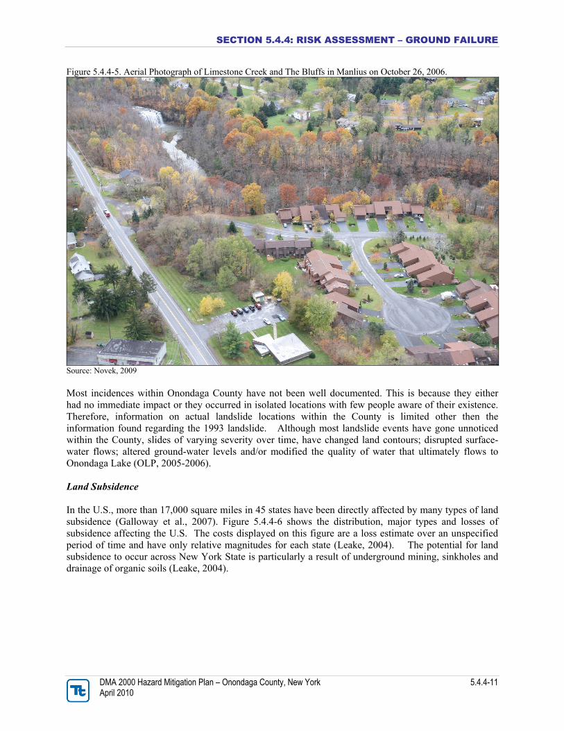
area. This inventory indicated that 73 total landslides have occurred, of which 22-percent (16) were classified as active/recently-active (present to 200 years), 52-percent (38) fall in the category old (200 to 10,000 years), and 26-percent (19) are termed ancient (10,000 to 40,000 years) (Jäger and Wieczorek, 2001; Tamulonis, 2007). The most recent and most documented landslide in Onondaga County and the Tully Valley area occurred on April 27, 1993 along the west wall of the Valley at the base of Bare Mountain. Debris from the landslide covered 1,500 feet of Tully Farms Road with more than 15 feet of mud. Three homes were destroyed due to this event. Most residents were away from their homes at the time, and no fatalities or serious injuries were reported (Pair et al., 2000). According to the NYSGS, this slide was the largest to have occurred in the State in more than 75 years. The location of this landslide, as well as other recent landslide events, is depicted on Figure 5.4.4-4. Details regarding this landslide event are discussed further in the “Previous Occurrences” section of this hazard profile. The 1993 Tully Valley landslide and smaller recently-active landslides in the area, particularly along the base of Bare Mountain, have resulted in property damage, suggesting that landslides are an important hazard and potential risk within this particularly area of Onondaga County (Jäger and Wieczorek, 2001). In the aftermath of the 1993 Tully Valley landslide, residents and public officials became concerned about the potential landslide hazards in settings similar to the Tully Valley within the County. Federal and State environmental agencies and several universities conducted many studies and investigations in the Tully Valley area to identify the cause of landslides and assess the potential for future landslides (Pair, et al., 2000). Also, the USGS and the NYSGS prepared a map of 160 square miles of southern Onondaga County showing the susceptibility to landsliding categorized as low, moderate, or high. The map has been used by the cities of Tully and LaFayette and agencies of Onondaga County. Results of investigations for landslide potential, followed by mitigation efforts before land-use development, help prevent or reduce most adverse economic consequences of landslides (USGS, 1996; Kappel and McPherson, 1998). The Bluffs (along Bluffview) in the Town of Manlius overlooking Limestone Creek have experienced ground failure in the past. According to an Engineering Feasibility Study conducted in 2005, four attached condominiums along Bluffview in the Town of Manlius were constructed (before 1994) close to the edge of an approximately 80-foot high bluff overlooking Limestone Creek (The Bluffs). In May 2002, an approximate 40-foot wide area of the bluff slid into Limestone Creek carrying the ground surrounding the south-side of condominium unit 8181. The earth slope failed after a heavy rain event. According to the study, a glacial till layer (fine-grained silt, sand, gravel, cobbles and boulders) supports the floors and footings of the condominiums which is susceptible to erosion by precipitation and roof runoff. The bedrock below the soil is ‘thinly bedded and fractured limestone that is susceptible to surface unraveling from weathering.” The study also states that deeper large scale instability in the rock cannot be ruled out and without repair, the building’s structure will eventually suffer (John P. Stopen Engineering Partnership, 2005). Figure 5.4.4-5 shows an aerial photograph of the Limestone Creek and the Bluffs in Manlius on October 26, 2006.
SECTION 5.4.4: RISK ASSESSMENT – GROUND FAILURE
DMA 2000 Hazard Mitigation Plan – Onondaga County, New York 5.4.4-11 April 2010
Figure 5.4.4-5. Aerial Photograph of Limestone Creek and The Bluffs in Manlius on October 26, 2006.
Source: Novek, 2009 Most incidences within Onondaga County have not been well documented. This is because they either had no immediate impact or they occurred in isolated locations with few people aware of their existence. Therefore, information on actual landslide locations within the County is limited other then the information found regarding the 1993 landslide. Although most landslide events have gone unnoticed within the County, slides of varying severity over time, have changed land contours; disrupted surface-water flows; altered ground-water levels and/or modified the quality of water that ultimately flows to Onondaga Lake (OLP, 2005-2006). Land Subsidence In the U.S., more than 17,000 square miles in 45 states have been directly affected by many types of land subsidence (Galloway et al., 2007). Figure 5.4.4-6 shows the distribution, major types and losses of subsidence affecting the U.S. The costs displayed on this figure are a loss estimate over an unspecified period of time and have only relative magnitudes for each state (Leake, 2004). The potential for land subsidence to occur across New York State is particularly a result of underground mining, sinkholes and drainage of organic soils (Leake, 2004).
SECTION 5.4.4: RISK ASSESSMENT – GROUND FAILURE
DMA 2000 Hazard Mitigation Plan – Onondaga County, New York 5.4.4-12 April 2010
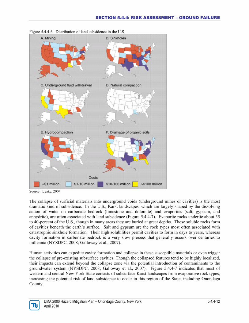
Figure 5.4.4-6. Distribution of land subsidence in the U.S
Source: Leake, 2004 The collapse of surficial materials into underground voids (underground mines or cavities) is the most dramatic kind of subsidence. In the U.S., Karst landscapes, which are largely shaped by the dissolving action of water on carbonate bedrock (limestone and dolomite) and evaporites (salt, gypsum, and anhydrite), are often associated with land subsidence (Figure 5.4.4-7). Evaporite rocks underlie about 35 to 40-percent of the U.S., though in many areas they are buried at great depths. These soluble rocks form of cavities beneath the earth’s surface. Salt and gypsum are the rock types most often associated with catastrophic sinkhole formation. Their high solubilities permit cavities to form in days to years, whereas cavity formation in carbonate bedrock is a very slow process that generally occurs over centuries to millennia (NYSDPC, 2008; Galloway et al., 2007). Human activities can expedite cavity formation and collapse in these susceptible materials or even trigger the collapse of pre-existing subsurface cavities. Though the collapsed features tend to be highly localized, their impacts can extend beyond the collapse zone via the potential introduction of contaminants to the groundwater system (NYSDPC, 2008; Galloway et al., 2007). Figure 5.4.4-7 indicates that most of western and central New York State consists of subsurface Karst landscapes from evaporative rock types, increasing the potential risk of land subsidence to occur in this region of the State, including Onondaga County.
SECTION 5.4.4: RISK ASSESSMENT – GROUND FAILURE
DMA 2000 Hazard Mitigation Plan – Onondaga County, New York 5.4.4-13 April 2010
Figure 5.4.4-7. Rock Types Associated with Land Subsidence Collapse throughout the U.S.
Source: Galloway et al., 2007 As indicated further in Figure 5.4.4-8, most of Onondaga County consists of subsurface rock types that create a high potential for land subsidence to occur, particularly in the southern half of the County where the Tully Valley exists. Figure 5.4.4-8. Mineral Resources in Central New York State
Source: NYSDPC, 2008 Note: Information provided by the New York State Museum in 2003
SECTION 5.4.4: RISK ASSESSMENT – GROUND FAILURE
DMA 2000 Hazard Mitigation Plan – Onondaga County, New York 5.4.4-14 April 2010
These rock types and conditions have contributed to subsidence events in the Tully Valley area of Onondaga County. Documented subsidence within the Tully Valley area has been attributed to:
• Discharge of mudboil sediments;
• Salt-solution mining; or
• Aquifer dewatering of fine-grained deposits (Kappel, 2009).
The discharge of mudboil sediments and salt-solution mining have been the main causes of subsidence within the Tully Valley, and are further described below: Mudboils: Mudboils have been documented in the Tully Valley since the late 1890s and have continuously discharged sediment-laden (turbid) water into nearby Onondaga Creek since the 1950s. This discharge causes turbidity in the Creek, which is a tributary to Onondaga Lake. Mudboil activity has caused a gradual land-surface subsidence that has led to the rerouting of a major petroleum pipeline and a buried telephone cable, and caused two road bridges to collapse. Figure 5.4.4-9 illustrates the approximate location of where mudboil activity continues to occur in southern Onondaga County (Kappel, 2009).
SECTION 5.4.4: RISK ASSESSMENT – GROUND FAILURE
DMA 2000 Hazard Mitigation Plan – Onondaga County, New York 5.4.4-15 April 2010
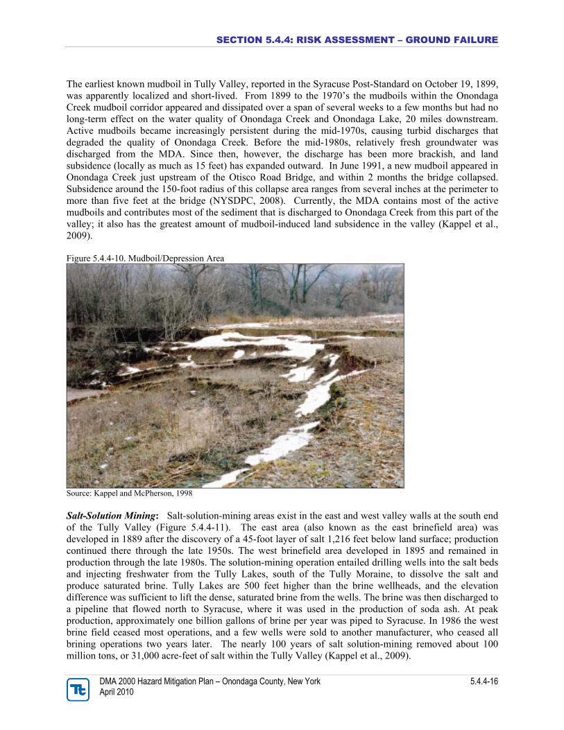
Figure 5.4.4-9. Geographic Features of Tully Valley
Source: Kappel, 2009 Mudboil discharge within the County is driven by artesian pressure in unconsolidated sediments that are confined by a 60-foot layer of silt and red clay. This process, once begun, has been self-propagating. Artesian pressures are about 20 feet above land surface over most of the Tully Valley floor but exceed 30 feet above land surface along Onondaga Creek where Rattlesnake Gulf and Rainbow Creek enter the Tully Valley (Figure 5.4.4-9). The source of artesian pressure is recharge from the Tully (Valley Heads) Moraine at the south end of the valley, and the alluvial fans of Rattlesnake Gulf and Rainbow Creek (Kappel et al., 2009). Mudboils have been observed in the Tully Valley for nearly 100 years. Most of the mudboils are in two areas of the Tully Valley: (1) the Onondaga Creek mudboil “corridor,” which is 1,500 feet long and 300 feet wide along Onondaga Creek, south of Otisco Road, and (2) the 5-acre area of subsidence, locally known as the mudboil/depression area (MDA), just west of the southern (upstream) end of the mudboil corridor (Figure 5.4.4-10).
SECTION 5.4.4: RISK ASSESSMENT – GROUND FAILURE
DMA 2000 Hazard Mitigation Plan – Onondaga County, New York 5.4.4-16 April 2010
The earliest known mudboil in Tully Valley, reported in the Syracuse Post-Standard on October 19, 1899, was apparently localized and short-lived. From 1899 to the 1970’s the mudboils within the Onondaga Creek mudboil corridor appeared and dissipated over a span of several weeks to a few months but had no long-term effect on the water quality of Onondaga Creek and Onondaga Lake, 20 miles downstream. Active mudboils became increasingly persistent during the mid-1970s, causing turbid discharges that degraded the quality of Onondaga Creek. Before the mid-1980s, relatively fresh groundwater was discharged from the MDA. Since then, however, the discharge has been more brackish, and land subsidence (locally as much as 15 feet) has expanded outward. In June 1991, a new mudboil appeared in Onondaga Creek just upstream of the Otisco Road Bridge, and within 2 months the bridge collapsed. Subsidence around the 150-foot radius of this collapse area ranges from several inches at the perimeter to more than five feet at the bridge (NYSDPC, 2008). Currently, the MDA contains most of the active mudboils and contributes most of the sediment that is discharged to Onondaga Creek from this part of the valley; it also has the greatest amount of mudboil-induced land subsidence in the valley (Kappel et al., 2009). Figure 5.4.4-10. Mudboil/Depression Area
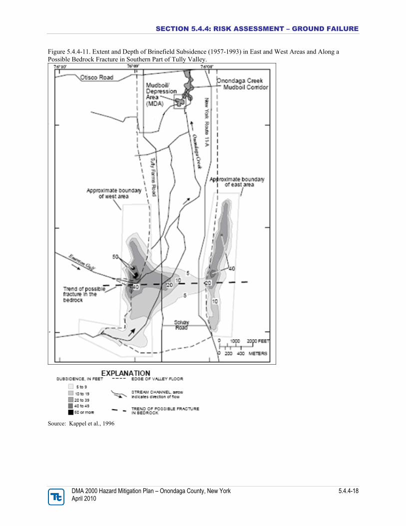
Source: Kappel and McPherson, 1998 Salt-Solution Mining: Salt-solution-mining areas exist in the east and west valley walls at the south end of the Tully Valley (Figure 5.4.4-11). The east area (also known as the east brinefield area) was developed in 1889 after the discovery of a 45-foot layer of salt 1,216 feet below land surface; production continued there through the late 1950s. The west brinefield area developed in 1895 and remained in production through the late 1980s. The solution-mining operation entailed drilling wells into the salt beds and injecting freshwater from the Tully Lakes, south of the Tully Moraine, to dissolve the salt and produce saturated brine. Tully Lakes are 500 feet higher than the brine wellheads, and the elevation difference was sufficient to lift the dense, saturated brine from the wells. The brine was then discharged to a pipeline that flowed north to Syracuse, where it was used in the production of soda ash. At peak production, approximately one billion gallons of brine per year was piped to Syracuse. In 1986 the west brine field ceased most operations, and a few wells were sold to another manufacturer, who ceased all brining operations two years later. The nearly 100 years of salt solution-mining removed about 100 million tons, or 31,000 acre-feet of salt within the Tully Valley (Kappel et al., 2009).
SECTION 5.4.4: RISK ASSESSMENT – GROUND FAILURE
DMA 2000 Hazard Mitigation Plan – Onondaga County, New York 5.4.4-17 April 2010
Initial solution mining in the east brinefield area resulted in the removal of most of the 35- to 45-foot-thick salt layer at 31 wells. Early and frequent caving within the solution-mined cavities was documented, but no general surface subsidence was noted. Surface-subsidence measurements did not begin in either brinefield area until the late 1950s. From 1895 through 1900, 21 solution wells were drilled in the western brinefield area and resulted in similar caving. As more wells were drilled into the deeper salt beds, other well-development and pumping strategies were tried in an attempt to decrease the caving and increase brine production. By 1950, a total of 99 wells had been drilled in the eastern and western areas, 86 of which were abandoned as a result of caving, shearing of well casings, and the collapse of the overlying bedrock into solution-mined salt cavities (Kappel et al., 2009). As early as 1943, general land subsidence and development of rock fissures along the eastern side of the east brine field area were noted. In the late 1950’s, subsequent development of several chimney-collapse areas (or rock-filled cylinders) prompted land-subsidence surveys in both brine field areas. The extent of land subsidence due to the removal of salt since 1957, when the initial survey was made, is depicted in Figure 5.4.4-11. This map indicates subsidence of 5 feet to more than 50 feet in the two brine-field areas. Although subsidence outside the brine field has not been documented, local landowners have noted bedrock fracturing upslope of the east brinefield area (Kappel et al., 2009).
SECTION 5.4.4: RISK ASSESSMENT – GROUND FAILURE
DMA 2000 Hazard Mitigation Plan – Onondaga County, New York 5.4.4-18 April 2010
Figure 5.4.4-11. Extent and Depth of Brinefield Subsidence (1957-1993) in East and West Areas and Along a Possible Bedrock Fracture in Southern Part of Tully Valley.
Source: Kappel et al., 1996
SECTION 5.4.4: RISK ASSESSMENT – GROUND FAILURE
DMA 2000 Hazard Mitigation Plan – Onondaga County, New York 5.4.4-19 April 2010
Previous Occurrences and Losses Many sources provided historical information regarding ground failures events in Onondaga County. Ground failure events within the County occurred in the Tully Valley area in the form of a landslide or land subsidence. According to a landslide inventory prepared by the USGS and Department of Geography at the University of Heidelberg, landslide history of the Tully Valley dates back 14,000 years ago. This inventory indicates that 73 total landslides have occurred, of which 22-percent (16) are classified as active/recently-active (present to 200 years), 52-percent (38) fall in the category old (200 to 10,000 years), and 26-percent (19) are termed ancient (10,000 to 40,000 years) (Jäger and Wieczorek, 2001; Tamulonis, 2007). The approximate location of these 73 landslide events was not available in the documents reviewed for this plan. Most landslide events within the Tully Valley area were an immediate occurrence with little to no warning. However, land subsidence within the County occurred over a longer period of time. The approximate date or period of occurrence of many landslides or land subsidence events is unknown. Additionally, many landslide or land subsidence events may have occurred in remote areas causing their existence or impact to go unnoticed. Therefore, this hazard profile may not identify all ground failure events that have impacted the County.
SECTION 5.4.4: RISK ASSESSMENT – GROUND FAILURE
DMA 2000 Hazard Mitigation Plan – Onondaga County, New York 5.4.4-20 April 2010
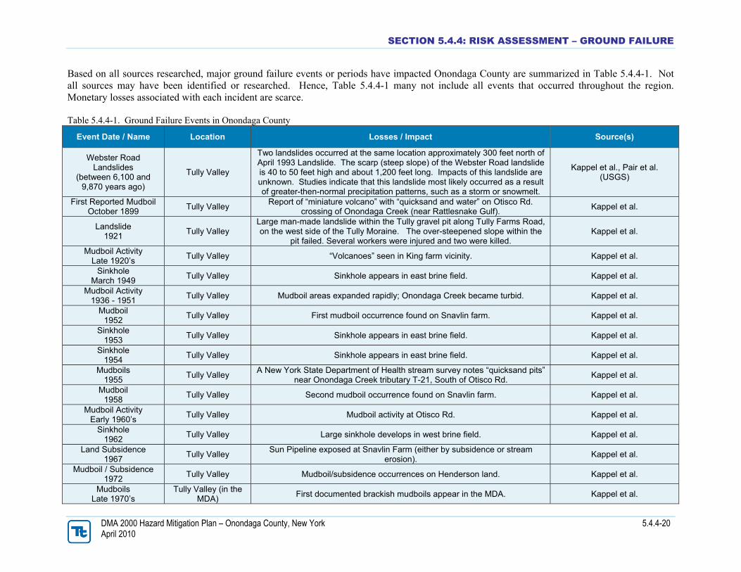
Based on all sources researched, major ground failure events or periods have impacted Onondaga County are summarized in Table 5.4.4-1. Not all sources may have been identified or researched. Hence, Table 5.4.4-1 many not include all events that occurred throughout the region. Monetary losses associated with each incident are scarce. Table 5.4.4-1. Ground Failure Events in Onondaga County
Event Date / Name Location Losses / Impact Source(s)
Webster Road Landslides
(between 6,100 and 9,870 years ago)
Tully Valley
Two landslides occurred at the same location approximately 300 feet north of April 1993 Landslide. The scarp (steep slope) of the Webster Road landslide is 40 to 50 feet high and about 1,200 feet long. Impacts of this landslide are unknown. Studies indicate that this landslide most likely occurred as a result of greater-then-normal precipitation patterns, such as a storm or snowmelt.
Kappel et al., Pair et al. (USGS)
First Reported Mudboil October 1899 Tully Valley Report of “miniature volcano” with “quicksand and water” on Otisco Rd.
crossing of Onondaga Creek (near Rattlesnake Gulf). Kappel et al.
Landslide 1921 Tully Valley
Large man-made landslide within the Tully gravel pit along Tully Farms Road, on the west side of the Tully Moraine. The over-steepened slope within the
pit failed. Several workers were injured and two were killed. Kappel et al.
Mudboil Activity Late 1920’s Tully Valley “Volcanoes” seen in King farm vicinity. Kappel et al.
Sinkhole March 1949 Tully Valley Sinkhole appears in east brine field. Kappel et al.
Mudboil Activity 1936 - 1951 Tully Valley Mudboil areas expanded rapidly; Onondaga Creek became turbid. Kappel et al.
Mudboil 1952 Tully Valley First mudboil occurrence found on Snavlin farm. Kappel et al.
Sinkhole 1953 Tully Valley Sinkhole appears in east brine field. Kappel et al.
Sinkhole 1954 Tully Valley Sinkhole appears in east brine field. Kappel et al.
Mudboils 1955 Tully Valley A New York State Department of Health stream survey notes “quicksand pits”
near Onondaga Creek tributary T-21, South of Otisco Rd. Kappel et al.
Mudboil 1958 Tully Valley Second mudboil occurrence found on Snavlin farm. Kappel et al.
Mudboil Activity Early 1960’s Tully Valley Mudboil activity at Otisco Rd. Kappel et al.
Sinkhole 1962 Tully Valley Large sinkhole develops in west brine field. Kappel et al.
Land Subsidence 1967 Tully Valley Sun Pipeline exposed at Snavlin Farm (either by subsidence or stream
erosion). Kappel et al.
Mudboil / Subsidence 1972 Tully Valley Mudboil/subsidence occurrences on Henderson land. Kappel et al.
Mudboils Late 1970’s
Tully Valley (in the MDA) First documented brackish mudboils appear in the MDA. Kappel et al.
SECTION 5.4.4: RISK ASSESSMENT – GROUND FAILURE
DMA 2000 Hazard Mitigation Plan – Onondaga County, New York 5.4.4-21 April 2010
Event Date / Name Location Losses / Impact Source(s)
Sinkholes 1979 Tully Valley Sinkhole appears near well in west brine field. Kappel et al.
Mudboil Activity 1983 - 1987 Tully Valley Significant increase in mudboil activity noted. Kappel et al.
Land Subsidence 1989 Tully Valley More than 9 feet of subsidence noted at former Sun Pipeline location since
1978. Kappel et al.
Mudboil / Subsidence June 1991 Tully Valley Otisco Road Bridge collapsed in response to mudboil-induced subsidence. Kappel et al., Kappel and
McPherson (USGS)
Landslide April 27, 1993 Tully Valley
The largest landslide in New York State since the early 1900's. It occurred on east-facing slope of Bare Mountain, between Nickols and Webster Roads. Three houses destroyed, four houses evacuated, 1,200 feet of Tully Farms Rd. covered with over 12 feet of mud and debris. The total volume of earth
moved by the slide is estimated to be about 1.3 million cubic yards. Most residents were away from their homes at the time of the slide; there were no
fatalities or serious injuries reported.
Kappel et al., NYSDPC, USGS, The Living Schoolbook
Landslide April 9, 2001
Town of Lafayette and Lysander Closed one road in Town of Lysander. NYSDPC
May 2002 Manlius
A landslide occurred at Limestone Creek in Manlius behind Suburban Park Apartments (also known as The Bluffs), just 1,000 feet below Edwards Falls. These apartments are currently located on the edge of a cliff. Homeowners
at 8181 Bluffview (one of four condominiums on the bluff) have incurred approximately $100K in costs to date.
Footprint Press Inc.; Novek, 2009
Landslide Fall 2004
Tully Valley (near Rainbow Creek)
A 1,000-foot long section of hillside collapsed into the Rainbow Creek channel from the eroded toe of a steep hillside. On the opposite side of the
stream channel, another shorter section of hillside also collapsed. OLP
Landslide April 2005
Tully Valley (near Rattlesnake Gulf)
A 1,200-foot section of the hillside in the middle reach of Rattlesnake Gulf failed. As the hillside gave away, large masses of clay slid into the bedrock ravine, blocking the stream and causing massive amounts of sediment to
flow downstream to Tully Farms Road. Several farm fields were inundated with water, sand and gravel deposits.
OLP
MDA Mudboil/Depression Area NYSDPC New York State Disaster Preparedness Commission OLP Onondaga Lake Partnership USGS U.S. Geological Survey
SECTION 5.4.4: RISK ASSESSMENT – GROUND FAILURE
DMA 2000 Hazard Mitigation Plan – Onondaga County, New York 5.4.4-22 April 2010
Further descriptions of select ground failure events that have impacted Onondaga County are provided below with details regarding their impact (where available). As discussed earlier, land subsidence has generally occurred gradually over an extended period of time within the Tully Valley; therefore, information on a specific event or incident was scarce. Therefore, only major landslide events are mentioned below. These descriptions are provided to give the reader a context of the landslide events that have affected the County and to assist local officials in locating event-specific data for their municipalities based on the time and proximity of these events. Webster Road Landslide: A paleolandslide, referred to as the “Webster Road Landslide”, occurred over 6,100 years ago at the base of Bare Mountain in the Tully Valley area of Onondaga County. Based on a series of recent investigations, the geomorphology (geology and physical character) of the Webster Road landslide is strikingly similar to that of a 1993 landslide on Tully Farms Road, located 300-feet to the south (Figure 5.4.4-12). The scarp of the Webster Road Landslide is between 40 and 50 feet high and about 1,200 feet in length, whereas the scarp of the Tully Farms Road landslide between 30 and 50 feet high and 1,400 feet in length. Another similarity is the topography— large, transported soil blocks, some of which had retained vegetation and trees, were found at the base of the slope and within the toe of the 1993 landslide and have weathered such that the topography now resembles an area of hummocky ground at the toe of the Webster Road slide. Thus, the 1993 Tully Farms Road Landslide and the Webster Road Landslide are approximately the same size and probably displaced the same volume of material from the lower slope of Bare Mountain (Pair and Kappel, 2001; Pair et al., 2000). The age of the Webster Road Landslide was estimated from radiocarbon dating of peat-like organic and woody material found directly beneath mudflow deposits at several locations within the toe of the Webster Road landslide. Radiocarbon ages on these organics indicate that the land surface and associated vegetation were buried by a mudflow approximately 6,100 years ago (Pair and Kappel, 2001). This landslide is further depicted in Figure 5.4.4-12 under the 1993 Tully Farms Road description. Figure 5.4.4-12. Aerial View of Webster Road and 1993 Tully Farms Road Landslides
Source: Pair and Kappel, 2001 Note: Aerial view of the 1993 Tully Farms Road landslide taken May 1, 1993, 4 days after the slide occurred, and approximate location of Webster Road landslide to the north. Dashed lines indicate probable extent of the Webster Road landslide beyond Onondaga Creek. Numbers reference figures located in the Pair / Kappel report.
SECTION 5.4.4: RISK ASSESSMENT – GROUND FAILURE
DMA 2000 Hazard Mitigation Plan – Onondaga County, New York 5.4.4-23 April 2010
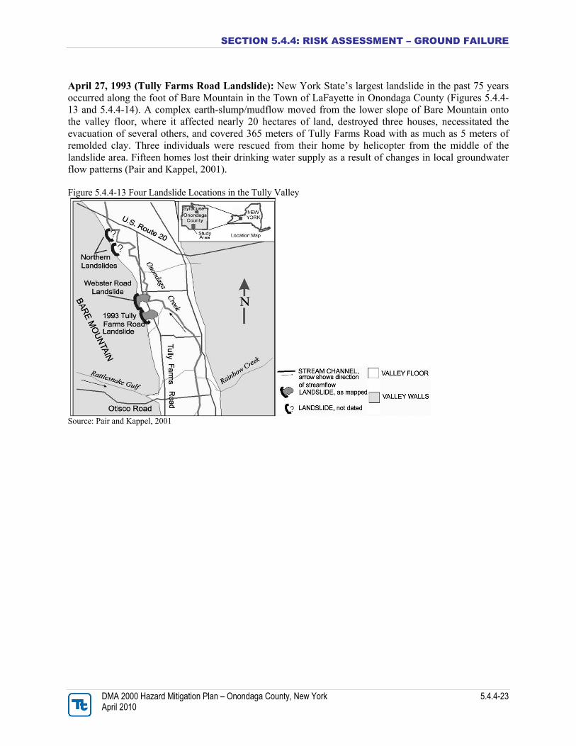
April 27, 1993 (Tully Farms Road Landslide): New York State’s largest landslide in the past 75 years occurred along the foot of Bare Mountain in the Town of LaFayette in Onondaga County (Figures 5.4.4-13 and 5.4.4-14). A complex earth-slump/mudflow moved from the lower slope of Bare Mountain onto the valley floor, where it affected nearly 20 hectares of land, destroyed three houses, necessitated the evacuation of several others, and covered 365 meters of Tully Farms Road with as much as 5 meters of remolded clay. Three individuals were rescued from their home by helicopter from the middle of the landslide area. Fifteen homes lost their drinking water supply as a result of changes in local groundwater flow patterns (Pair and Kappel, 2001). Figure 5.4.4-13 Four Landslide Locations in the Tully Valley
Source: Pair and Kappel, 2001
SECTION 5.4.4: RISK ASSESSMENT – GROUND FAILURE
DMA 2000 Hazard Mitigation Plan – Onondaga County, New York 5.4.4-24 April 2010
Figure 5.4.4-14. Photograph of Tully Farm Road Landslide
Source: Jäger and Wieczorek, 2001 Initial efforts were directed toward stabilizing the landslide and draining the water discharging from fresh and brackish springs at the base of the main scarp area. Remediation activities (construction of diversion ditches and road clearing) were funded and directed by the NRCS through their Watershed Protection Program. The Onondaga County Department of Highways constructed all remedial works. Media coverage continued over the ensuing weeks, and several town meetings were held to keep the affected residents informed as to the stability of the landslide and vicinity, how soon homeowners could safely return, when Tully Farms Road would be reopened, and when electric and telephone utilities would be restored (Pair and Kappel, 2001). Two weeks after the slide, the area was considered stable enough to allow most homeowners to return. However, Tully Farms Road remained blocked for several months because of the high water content of the remolded clay. Utility lines were redirected from either end of the slide but still do not pass through the slide area. A local citizens group, the Tully Valley Conservation Association, quickly formed to secure financial aid because the economic losses were not large enough to warrant financial aid under federal or state disaster formulas. The citizens met with a Deputy White House Secretary who assembled representatives from several federal agencies. As a result of this meeting, affected landowners received small loans and grants to assist in either rebuilding or relocating. Within about a year, residents whose houses had been destroyed or severely damaged had relocated. About 10 landowners within and adjacent to the slide area received a property-tax reduction from the Town of LaFayette as a means of providing further economic relief. Soon after the 1993 slide occurred, 15 households north of the 1993 landslide lost their water supply from springs within the scarp of the Webster Road landslide area. These ‘‘reliable’’ springs remained dry during the summer of 1993, which forced the residents to obtain water from other sources. At present, the springs flow from the late fall through spring but are dry the remainder of the year. The Town of Lafayette has sought alternative sources of water for these residents but found that connection to the county water-authority system or development of nearby water sources for a small community system would be too costly. Efforts to
SECTION 5.4.4: RISK ASSESSMENT – GROUND FAILURE
DMA 2000 Hazard Mitigation Plan – Onondaga County, New York 5.4.4-25 April 2010
supply water for these residents continue, but the costs associated with a community-based water supply remain prohibitive (Pair and Kappel, 2001). In the seven years following the 1993 slide, several studies were conducted by federal and state environmental agencies and by local universities to identify the cause of the 1993 landslide; investigate the history of landslides within the area and assess the potential for future landslides (Pair and Kappel, 2001). These studies identified several geologic, climatologic, and hydrologic factors as probable causes of the 1993 Tully Farms Road landslide, including:
• Interbeds of clay within the sand and gravel deposit at the base of the hillside: The fresh scarp face of the 1993 landslide reveals interbeds of clay within the sand and gravel deposit. These clay layers could have trapped groundwater in the coarse sand and gravel, and when the artesian pressure exceeded the weight of the overlying soil, this may have led to soil movement. Also, below the clay and sand and gravel interbeds is a thick lacustrine unit with a stiffupper part and an extremely soft middle that possibly created a “slip surface.”
• A dense till layer below the clay, sand, and gravel: This unit confines brackish water in the bedrock aquifer and separates it from freshwater in the upper aquifer. Pressure from the confined brackish water may have increased the artesian pressure in the overlying glacial and colluvial sediments.
• Instability of the lower hillside in the Tully Farms Road landslide area before 1993: In 1990, the New York State Department of Environmental Conservation noted ground cracks, earth bulging, and slumping on the lower hillside. The basement wall of a house along Tully Farms Road was slowly failing in 1992, apparently from the increasing soil pressure on the wall facing Bare Mountain.
• Greater-than-normal snowfall in the winter of 1992-93, followed by the blizzard of March 1993: Snow melt increased the water content of near-surface soils and increased the artesian pressures in the confined interbed unit. This condition, followed by heavy rainfall in April, increased the already greater-than-normal surface-water and groundwater flow throughout the Tully Valley and increased pore-water pressures within the interbed units along the base of Bare Mountain. This pressure, coupled with the unstable soil conditions along the lower slope, resulted in the April 27, 1993 landslide (Pair et. al., 2000; Pair and Kappel, 2001).
Scientists have concluded that the 1993 slide was the result of a combination of natural processes. Despite newspaper accounts speculating otherwise, no human activity, such as land-use changes (the backscarp of the slide was within a cultivated area at the base of a forested hillside) or brine field operations at the southern end of the valley, appears to have played a role (Pair and Kappel, 2001). Monetary losses in the Tully Valley associated with this landslide were not available in the materials reviewed for this plan. May 2002: Four attached condominiums along Bluffview in the Town of Manlius (The Bluffs) located close to the edge of an approximately 80-foot high bluff overlooking Limestone Creek, experienced a landslide/ground failure in May of 2002. In May 2002, an approximate 40-foot wide area of the bluff slid into Limestone Creek carrying the ground surrounding the south-side of condominium unit 8181. The earth slope failed after a heavy rain event. According to an Engineering Feasibility Study conducted, if repair is not done, the building’s structure will eventually suffer. A remedy suggested in the study is to strengthen the ground in order to stabilize the slope utilizing soil nails (steel bars) and heavy steel cable netting. At the time this study was published, the estimated cost of the project was approximately $350,000 and $440,000 (2005 dollars) (John P. Stopen Engineering Partnership, 2005). Homeowners are still living at 8181 Bluffview and are concerned for their safety and the structural soundness of their
SECTION 5.4.4: RISK ASSESSMENT – GROUND FAILURE
DMA 2000 Hazard Mitigation Plan – Onondaga County, New York 5.4.4-26 April 2010
home. They have tried to mitigate the ground failure behind their home and have incurred tremendous costs in doing so (over $100K) (Novek, 2009). Figures 5.4.4-15 and 5.4.4-16 illustrate the slope behind 8181 Bluffview. Figure 5.4.4-15. Aerial Photograph of The Bluffs on October 26, 2006.
Source: Novek, 2009
SECTION 5.4.4: RISK ASSESSMENT – GROUND FAILURE
DMA 2000 Hazard Mitigation Plan – Onondaga County, New York 5.4.4-27 April 2010
Figure 5.4.4-16. The Rear of 8181 Bluffview Drive in Manlius on April 30, 2007
Source: Novek, 2009 Notes: This photograph was taken prior to a jute mat placed on the soil behind this unit to mitigate the eroding soil. Fall 2004 through Spring 2005 (Landslides): The southern Onondaga Valley experienced two landslides in 2004 and 2005. These landslides occurred in isolated locations, therefore few people know of their existence. Residents became aware of these events because nearby streams carried massive
SECTION 5.4.4: RISK ASSESSMENT – GROUND FAILURE
DMA 2000 Hazard Mitigation Plan – Onondaga County, New York 5.4.4-28 April 2010
amounts of sediment down to the valley floor blocking bridge openings and flooding adjacent farm fields (OLP, 2005-2006). During the fall of 2004, excess rainfall and runoff from several tropical storms resulted in over-saturated soil conditions on the upper slopes of Rainbow Creek, between Interstate-81 and U.S. Route 11A in the Tully Valley. A 1,000-foot long section of hillside collapsed into the creek channel from the eroded toe of a steep hillside. On the opposite side of the stream channel, another shorter section of hillside also collapsed. Most of the hillside was sand and gravel, and much of this sediment traveled rapidly downstream and eventually clogged two 6-foot culverts under Route 11A. Hundreds of truck loads of gravel had to be removed from the channel to allow the culverts to function properly and to prevent flooding of nearby property (OLP, 2005-2006). In April 2005, rapid snowmelt, followed by several days of persistent rain caused flooding throughout central and southern New York State. While the volume of flow measured in Onondaga Creek was not as great as that measured the previous fall, there was enough water to cause a 1,200-foot section of the hillside in the middle reach of Rattlesnake Gulf to fail. Unlike the Creek Rainbow Landslide, the Rattlesnake soils consist almost entirely clay and silt over bedrock. There were a number of streams flowing off the upper slopes into the landslide area, saturating the entire soil column. As the hillside gave way, large masses of clay, the size of homes slid into the bedrock ravine, blocking the stream and causing massive amounts of sediment to flow downstream to Tully Farms Road. A large buildup of sand and gravel was found at the Tully Farms Road bridge crossing of Rattlesnake Gulf. These sediments were removed from the area around the bridge, but downstream, the sediment forced the stream to abandon its channel and inundate several farm fields with water, sand and gravel deposits. Figure 5.4.4-17 illustrates damage from the Rattlesnake Gulf landslide, showing blocks of clay (not bedrock) that slid into the channel of the Rattlesnake Creek, partially blocking the flow of the stream (OLP, 2005-2006). Rattlesnake Gulf usually flows turbid each spring due to small slope failures. Review of aerial photography for the last 30 years indicates that this area has slowly been failing, probably due to a number of springs which saturate the hillside, but the spring runoff in 2005 probably caused the massive failure (The Upstate Freshwater Institute, 2008). Figure 5.4.4-17. Rattlesnake Gulf Landslide
Source: OLP, 2005-2006
SECTION 5.4.4: RISK ASSESSMENT – GROUND FAILURE
DMA 2000 Hazard Mitigation Plan – Onondaga County, New York 5.4.4-29 April 2010
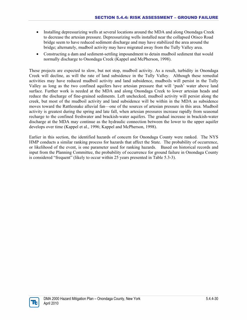
Probability of Future Events Landslides As indicated in the NYS HMP, given the history of landslide occurrences in New York State, it is certain that future landslides will occur. Therefore, the probability of future landslides in New York State is considered high. However, the severity of landslides cannot be determined. Using documented historical occurrences from the NYSGS Landslide Inventory Study to estimate the probability of future landslides, New York State can expect on average approximately two major landslides each year, a greater number of smaller but still significant slides/slumps/flows each year and at least one landslide causing a fatality, is expected once every 12 years. Although historical data indicates a high frequency of landslide occurrence, the NYSGS estimates that 80-percent of the State has a low susceptibility to landslides. The frequency of damaging landslides within and adjacent to New York State has been and can be classified, relative to other higher risk states, as low. However, the fact that high landslide susceptibility exists and landslides have occurred in the past suggests that the states infrastructure and many people are at risk from damaging landslide hazards in New York State. Onondaga County is one of the top 10 counties within New York State with a higher susceptibility to landslides. It is ranked as the 9th County in the state most threatened by landslides and vulnerable to landslides loss (NYSDPC, 2008). Therefore, Onondaga County is at greater risk of future landslide events than other sections of the State. Since landslides can occur as a result of many factors within Onondaga County, including past landslides and their distribution; bedrock; slope steepness or inclination, hydrologic factor and human-initiated effects; it is extremely difficult to predict landslide hazards in absolute terms (OAS, 1991). However, a sufficient understanding of landslide processes within the County does exist through various studies and mapping sources to be able to make an estimation of landslide hazard potential. The potential increase in the risk posed by the landslide hazard can be curbed through a continued understanding and mapping of the hazards and improved capabilities to mitigate and respond to the landslide hazard (Spiker and Gori, 2000). Land Subsidence Given that land subsidence is a documented occurrence in New York State, including within Onondaga County, it is certain that future land subsidence will occur. With Onondaga County consisting of subsurface rock types that could further influence the risk of land subsidence, there is a possibility that the likelihood of subsidence could occur more frequently then other counties within the State. However, the sparse historical record of occurrences and the lack of comprehensive summarized and readily-available scientific studies make it difficult to predict the probability and severity of future occurrences and their locations (NYSDPC, 2008). Regarding mudboil activity in the Tully Valley, the OLP indicates that there is no way to predict future activity of the mudboils, although it is surmised that they won’t go away within the near future (OLP, Date Unknown). Since 1992, the Onondaga Lake Management Conference began remediation efforts to decrease mudboil discharge. Remediation projects have been designed to reduce artesian pressure that drives mudboil activity and decrease the discharge of sediment. Remedial efforts near the Tully Valley mudboils include:
• Diverting flow from the tributary that feeds the MDA to an adjacent tributary. The diversion of water and the impoundment of water and sediment at the MDA outflow, decreased mudboil-sediment discharge to Onondaga Creek by about 80-percent.
SECTION 5.4.4: RISK ASSESSMENT – GROUND FAILURE
DMA 2000 Hazard Mitigation Plan – Onondaga County, New York 5.4.4-30 April 2010
• Installing depressurizing wells at several locations around the MDA and along Onondaga Creek to decrease the artesian pressure. Depressurizing wells installed near the collapsed Otisco Road bridge seem to have reduced sediment discharge and may have stabilized the area around the bridge; alternately, mudboil activity may have migrated away from the Tully Valley area.
• Constructing a dam and sediment-settling impoundment to detain mudboil sediment that would normally discharge to Onondaga Creek (Kappel and McPherson, 1998).
These projects are expected to slow, but not stop, mudboil activity. As a result, turbidity in Onondaga Creek will decline, as will the rate of land subsidence in the Tully Valley. Although these remedial activities may have reduced mudboil activity and land subsidence, mudboils will persist in the Tully Valley as long as the two confined aquifers have artesian pressure that will ‘push’ water above land surface. Further work is needed at the MDA and along Onondaga Creek to lower artesian heads and reduce the discharge of fine-grained sediments. Left unchecked, mudboil activity will persist along the creek, but most of the mudboil activity and land subsidence will be within in the MDA as subsidence moves toward the Rattlesnake alluvial fan—one of the sources of artesian pressure in this area. Mudboil activity is greatest during the spring and late fall, when artesian pressures increase rapidly from seasonal recharge to the confined freshwater and brackish-water aquifers. The gradual increase in brackish-water discharge at the MDA may continue as the hydraulic connection between the lower to the upper aquifer develops over time (Kappel et al., 1996; Kappel and McPherson, 1998). Earlier in this section, the identified hazards of concern for Onondaga County were ranked. The NYS HMP conducts a similar ranking process for hazards that affect the State. The probability of occurrence, or likelihood of the event, is one parameter used for ranking hazards. Based on historical records and input from the Planning Committee, the probability of occurrence for ground failure in Onondaga County is considered “frequent” (likely to occur within 25 years presented in Table 5.3-3).
SECTION 5.4.4: RISK ASSESSMENT – GROUND FAILURE
DMA 2000 Hazard Mitigation Plan – Onondaga County, New York 5.4.4-31 April 2010
VULNERABILITY ASSESSMENT To understand risk, a community must evaluate what assets are exposed or vulnerable in the identified hazard area. The following section discusses the potential impact of the ground failure hazard on Onondaga County including: • Overview of vulnerability • Data and methodology used for the evaluation • Impact, including: (1) impact on life, safety and health of County residents, (2) general building
stock, (3) critical facilities, (4) economy and (5) future growth and development • Further data collections that will assist understanding of this hazard over time • Overall vulnerability conclusion
Overview of Vulnerability Vulnerability to ground failure hazards is a function of location, geology, type of human activity, use, and frequency of events. The effects of ground failure on people and structures can be lessened by total avoidance of hazard areas or by restricting, prohibiting, or imposing conditions on hazard-zone activity. Local governments can reduce landslide effects through land use policies and regulations. Individuals can reduce their exposure to hazards by educating themselves on past hazard history of the site and by making inquiries to planning and engineering departments of local governments (National Atlas, 2007). As described earlier in this profile, Onondaga County has been ranked as the 9th county in New York State most threatened by landslides and vulnerable to landslide loss. A landslide hazard susceptibility map was created by NYSEMO based on a USGS landslide susceptibility map for New York State (Figure 5.4.4-3). According to this map, the northern portion of Onondaga County has a moderate susceptibility/low incidence to landslide, Tully Valley has a high susceptibility/moderate incidence to landslide and the remainder of the County has a low landslide incidence. Additionally, a large portion of the County is underlain by salt and gypsum rock; rock types associated with subsidence. The geology of the County in combination with historic human activities (brine mining) has made Onondaga vulnerable to ground failure (NYSDPC, 2008).
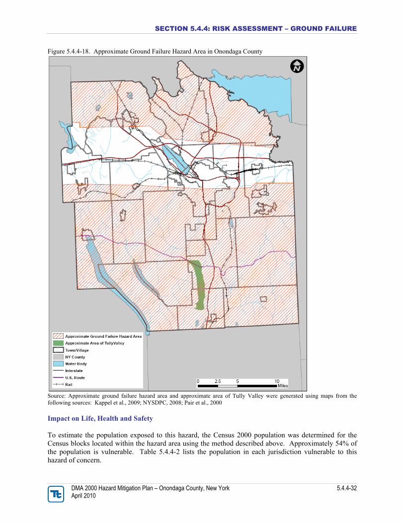
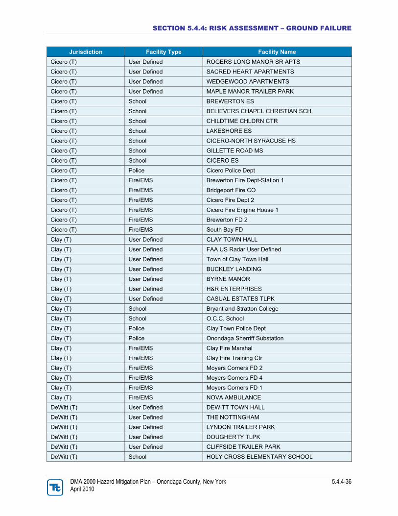
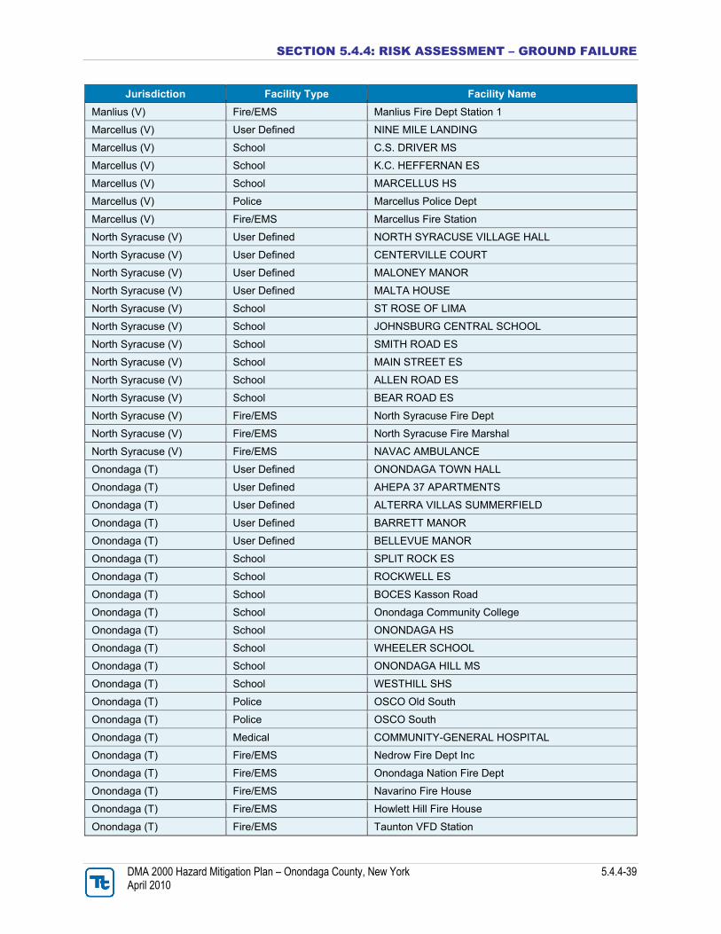
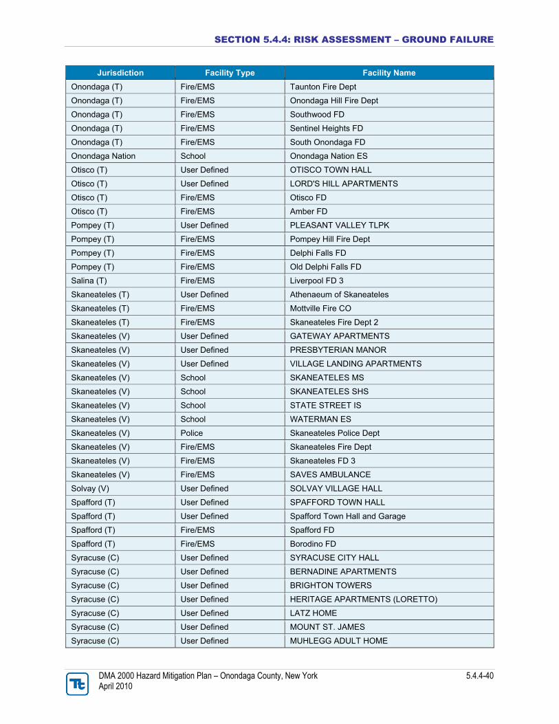
Data and Methodology To estimate the population and general building stock vulnerable to this hazard of concern, a GIS layer was created to capture the general ground failure susceptible area (hazard area) in Onondaga County (Figure 5.4.4-18). The area noted as “moderate susceptibility to landslide/low incidence” on the ‘Landslide Susceptibility’ map in the NYS HMP, Tully Valley, and the southern portion of the County underlain by salt were used to generate the approximate hazard area in GIS (see Figures 5.4.4-1, 5.4.4-3 and 5.4.4-8 earlier in this profile). This approximate hazard area encompasses historic ground failure sites and more localized hazard areas including the mudboil depression area, Onondaga Creek mudboil corridor and extent of brinefield subsidence in Tully Valley. This GIS layer was then overlaid upon the population and general building stock data available in HAZUS-MH MR3. The Census blocks with their center within the hazard area were used to estimate the population and building stock exposed to this hazard. As noted in the NYS HMP, the limitations of this analysis are recognized and are only used to provide a general estimate. Over time additional data will be collected to allow better analysis for this hazard. Available information and a preliminary assessment are provided below.
SECTION 5.4.4: RISK ASSESSMENT – GROUND FAILURE
DMA 2000 Hazard Mitigation Plan – Onondaga County, New York 5.4.4-32 April 2010
Figure 5.4.4-18. Approximate Ground Failure Hazard Area in Onondaga County
Source: Approximate ground failure hazard area and approximate area of Tully Valley were generated using maps from the following sources: Kappel et al., 2009; NYSDPC, 2008; Pair et al., 2000
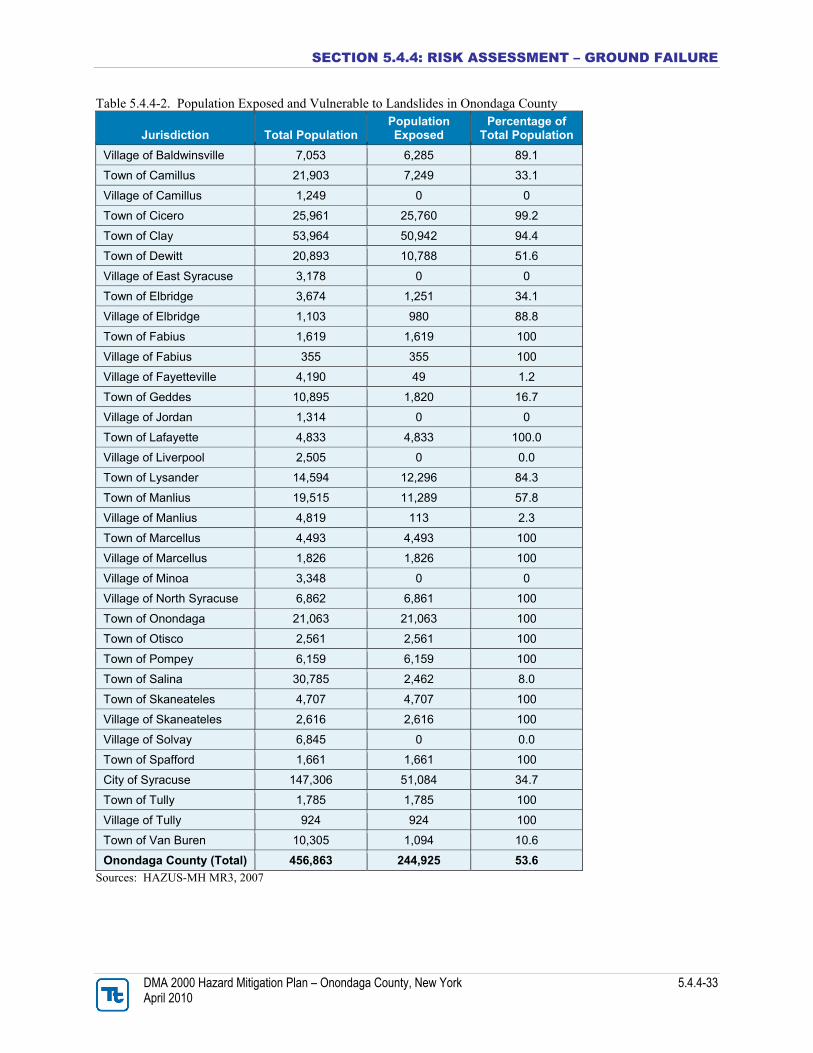
Impact on Life, Health and Safety To estimate the population exposed to this hazard, the Census 2000 population was determined for the Census blocks located within the hazard area using the method described above. Approximately 54% of the population is vulnerable. Table 5.4.4-2 lists the population in each jurisdiction vulnerable to this hazard of concern.
SECTION 5.4.4: RISK ASSESSMENT – GROUND FAILURE
DMA 2000 Hazard Mitigation Plan – Onondaga County, New York 5.4.4-33 April 2010
Table 5.4.4-2. Population Exposed and Vulnerable to Landslides in Onondaga County
Jurisdiction Total Population Population Exposed
Percentage of Total Population
Village of Baldwinsville 7,053 6,285 89.1
Town of Camillus 21,903 7,249 33.1
Village of Camillus 1,249 0 0
Town of Cicero 25,961 25,760 99.2
Town of Clay 53,964 50,942 94.4
Town of Dewitt 20,893 10,788 51.6
Village of East Syracuse 3,178 0 0
Town of Elbridge 3,674 1,251 34.1
Village of Elbridge 1,103 980 88.8
Town of Fabius 1,619 1,619 100
Village of Fabius 355 355 100
Village of Fayetteville 4,190 49 1.2
Town of Geddes 10,895 1,820 16.7
Village of Jordan 1,314 0 0
Town of Lafayette 4,833 4,833 100.0
Village of Liverpool 2,505 0 0.0
Town of Lysander 14,594 12,296 84.3
Town of Manlius 19,515 11,289 57.8
Village of Manlius 4,819 113 2.3
Town of Marcellus 4,493 4,493 100
Village of Marcellus 1,826 1,826 100
Village of Minoa 3,348 0 0
Village of North Syracuse 6,862 6,861 100
Town of Onondaga 21,063 21,063 100
Town of Otisco 2,561 2,561 100
Town of Pompey 6,159 6,159 100
Town of Salina 30,785 2,462 8.0
Town of Skaneateles 4,707 4,707 100
Village of Skaneateles 2,616 2,616 100
Village of Solvay 6,845 0 0.0
Town of Spafford 1,661 1,661 100
City of Syracuse 147,306 51,084 34.7
Town of Tully 1,785 1,785 100
Village of Tully 924 924 100
Town of Van Buren 10,305 1,094 10.6
Onondaga County (Total) 456,863 244,925 53.6
Sources: HAZUS-MH MR3, 2007
SECTION 5.4.4: RISK ASSESSMENT – GROUND FAILURE
DMA 2000 Hazard Mitigation Plan – Onondaga County, New York 5.4.4-34 April 2010
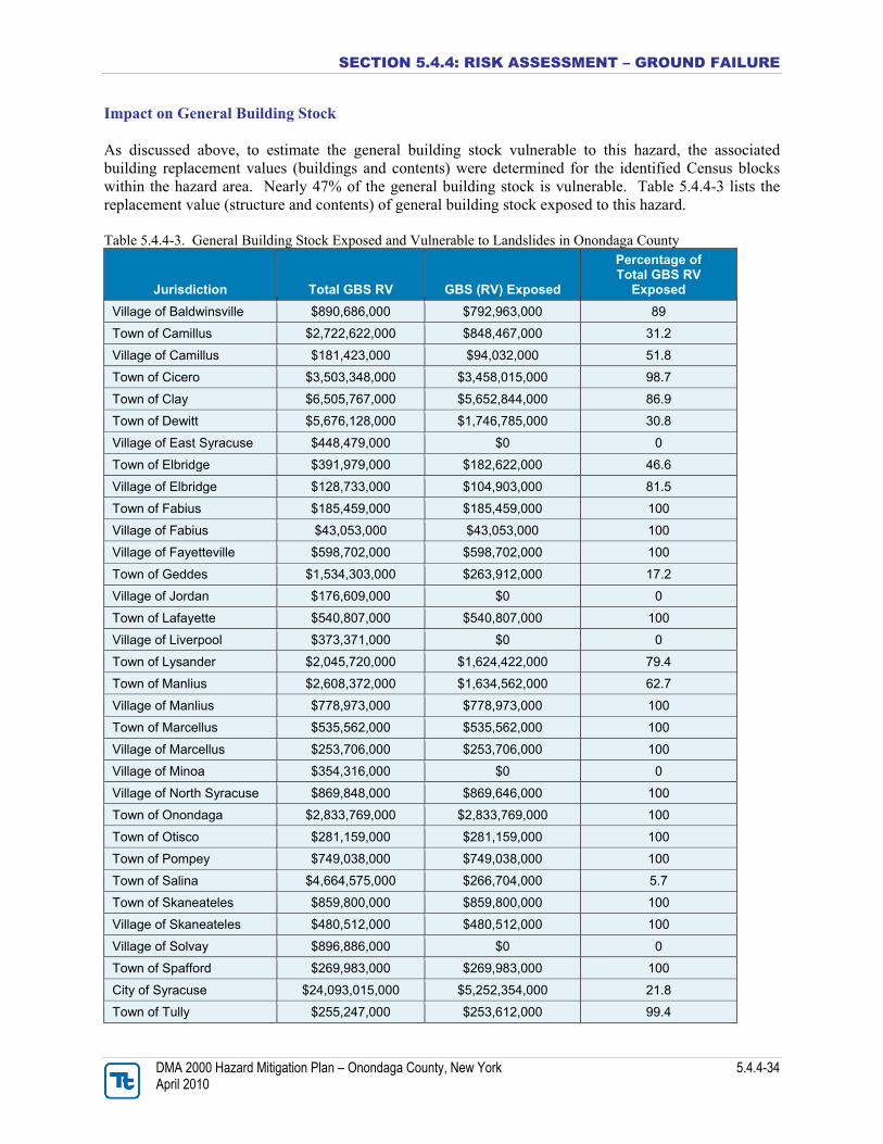
Impact on General Building Stock As discussed above, to estimate the general building stock vulnerable to this hazard, the associated building replacement values (buildings and contents) were determined for the identified Census blocks within the hazard area. Nearly 47% of the general building stock is vulnerable. Table 5.4.4-3 lists the replacement value (structure and contents) of general building stock exposed to this hazard. Table 5.4.4-3. General Building Stock Exposed and Vulnerable to Landslides in Onondaga County
Jurisdiction Total GBS RV GBS (RV) Exposed
Percentage of Total GBS RV
Exposed
Village of Baldwinsville $890,686,000 $792,963,000 89
Town of Camillus $2,722,622,000 $848,467,000 31.2
Village of Camillus $181,423,000 $94,032,000 51.8
Town of Cicero $3,503,348,000 $3,458,015,000 98.7
Town of Clay $6,505,767,000 $5,652,844,000 86.9
Town of Dewitt $5,676,128,000 $1,746,785,000 30.8
Village of East Syracuse $448,479,000 $0 0
Town of Elbridge $391,979,000 $182,622,000 46.6
Village of Elbridge $128,733,000 $104,903,000 81.5
Town of Fabius $185,459,000 $185,459,000 100
Village of Fabius $43,053,000 $43,053,000 100
Village of Fayetteville $598,702,000 $598,702,000 100
Town of Geddes $1,534,303,000 $263,912,000 17.2
Village of Jordan $176,609,000 $0 0
Town of Lafayette $540,807,000 $540,807,000 100
Village of Liverpool $373,371,000 $0 0
Town of Lysander $2,045,720,000 $1,624,422,000 79.4
Town of Manlius $2,608,372,000 $1,634,562,000 62.7
Village of Manlius $778,973,000 $778,973,000 100
Town of Marcellus $535,562,000 $535,562,000 100
Village of Marcellus $253,706,000 $253,706,000 100
Village of Minoa $354,316,000 $0 0
Village of North Syracuse $869,848,000 $869,646,000 100
Town of Onondaga $2,833,769,000 $2,833,769,000 100
Town of Otisco $281,159,000 $281,159,000 100
Town of Pompey $749,038,000 $749,038,000 100
Town of Salina $4,664,575,000 $266,704,000 5.7
Town of Skaneateles $859,800,000 $859,800,000 100
Village of Skaneateles $480,512,000 $480,512,000 100
Village of Solvay $896,886,000 $0 0
Town of Spafford $269,983,000 $269,983,000 100
City of Syracuse $24,093,015,000 $5,252,354,000 21.8
Town of Tully $255,247,000 $253,612,000 99.4
SECTION 5.4.4: RISK ASSESSMENT – GROUND FAILURE
DMA 2000 Hazard Mitigation Plan – Onondaga County, New York 5.4.4-35 April 2010
Jurisdiction Total GBS RV GBS (RV) Exposed
Percentage of Total GBS RV
Exposed
Village of Tully $156,839,000 $156,839,000 100
Town of Van Buren $1,297,980,000 $135,305,000 10.4
Onondaga County (Total) $68,271,979,000 $31,748,510,000 46.5
Source: HAZUS-MH MR3 Notes: GBS = General Building Stock. RV = Replacement Value. The total building count and total replacement values are the sum of all seven general occupancy classifications (residential, commercial, industrial, agricultural, religious, government and educational) for that jurisdiction. The valuation of general building stock and loss estimates determined in Onondaga County were based on the default general building stock database provided in HAZUS-MH MR3. The general building stock valuations provided in HAZUS-MH MR3 are Replacement Cost Value from RS Means as of 2006. Due to a lack of data regarding past losses specific to Onondaga County or its municipalities, it is not possible at this time to estimate potential future losses to ground failure events.
Impact on Critical Facilities Table 5.4.4-4 lists the emergency critical facilities (i.e., police, fire, EOCs and hospitals) located within the Census Tracts identified as susceptible to landslides. Table 5.4.4-4. Emergency Critical Facilities Susceptible to Landslides in Onondaga County
Jurisdiction Facility Type Facility Name
Baldwinsville (V) User Defined CONIFER VILLAGE
Baldwinsville (V) User Defined MERCER MILL APARTMENTS
Baldwinsville (V) User Defined ST MARY'S APARTMENTS
Baldwinsville (V) School CHILDTIME CHILDRENS CENTER
Baldwinsville (V) Fire/EMS Baldwinsville Fire Dept
Baldwinsville (V) Fire/EMS Baldwinsville Vlg Fire Dept
Baldwinsville (V) Fire/EMS Plainville Fire District CO 3
Baldwinsville (V) Fire/EMS GBAC - Rescue
Camillus (T) School EAST HILL ES
Camillus (T) School CAMILLUS MS
Camillus (V) User Defined CAMILLUS VILLAGE HALL
Camillus (V) User Defined CONNELLY ACRES APTS
Camillus (V) Police Camillus PD Substation
Cicero (T) User Defined CICERO TOWN HALL
Cicero (T) User Defined BAY SHORE NORTH APTS
Cicero (T) User Defined COBBLESTONE SQUARE
Cicero (T) User Defined LUCILLE MANOR
SECTION 5.4.4: RISK ASSESSMENT – GROUND FAILURE
DMA 2000 Hazard Mitigation Plan – Onondaga County, New York 5.4.4-36 April 2010
Jurisdiction Facility Type Facility Name
Cicero (T) User Defined ROGERS LONG MANOR SR APTS
Cicero (T) User Defined SACRED HEART APARTMENTS
Cicero (T) User Defined WEDGEWOOD APARTMENTS
Cicero (T) User Defined MAPLE MANOR TRAILER PARK
Cicero (T) School BREWERTON ES
Cicero (T) School BELIEVERS CHAPEL CHRISTIAN SCH
Cicero (T) School CHILDTIME CHLDRN CTR
Cicero (T) School LAKESHORE ES
Cicero (T) School CICERO-NORTH SYRACUSE HS
Cicero (T) School GILLETTE ROAD MS
Cicero (T) School CICERO ES
Cicero (T) Police Cicero Police Dept
Cicero (T) Fire/EMS Brewerton Fire Dept-Station 1
Cicero (T) Fire/EMS Bridgeport Fire CO
Cicero (T) Fire/EMS Cicero Fire Dept 2
Cicero (T) Fire/EMS Cicero Fire Engine House 1
Cicero (T) Fire/EMS Brewerton FD 2
Cicero (T) Fire/EMS South Bay FD
Clay (T) User Defined CLAY TOWN HALL
Clay (T) User Defined FAA US Radar User Defined
Clay (T) User Defined Town of Clay Town Hall
Clay (T) User Defined BUCKLEY LANDING
Clay (T) User Defined BYRNE MANOR
Clay (T) User Defined H&R ENTERPRISES
Clay (T) User Defined CASUAL ESTATES TLPK
Clay (T) School Bryant and Stratton College
Clay (T) School O.C.C. School
Clay (T) Police Clay Town Police Dept
Clay (T) Police Onondaga Sherriff Substation
Clay (T) Fire/EMS Clay Fire Marshal
Clay (T) Fire/EMS Clay Fire Training Ctr
Clay (T) Fire/EMS Moyers Corners FD 2
Clay (T) Fire/EMS Moyers Corners FD 4
Clay (T) Fire/EMS Moyers Corners FD 1
Clay (T) Fire/EMS NOVA AMBULANCE
DeWitt (T) User Defined DEWITT TOWN HALL
DeWitt (T) User Defined THE NOTTINGHAM
DeWitt (T) User Defined LYNDON TRAILER PARK
DeWitt (T) User Defined DOUGHERTY TLPK
DeWitt (T) User Defined CLIFFSIDE TRAILER PARK
DeWitt (T) School HOLY CROSS ELEMENTARY SCHOOL
SECTION 5.4.4: RISK ASSESSMENT – GROUND FAILURE
DMA 2000 Hazard Mitigation Plan – Onondaga County, New York 5.4.4-37 April 2010
Jurisdiction Facility Type Facility Name
DeWitt (T) School MANLIUS-PEBBLE HILL SCHOOL
DeWitt (T) School MOSES DEWITT ES
DeWitt (T) School Jamesville-Dewitt HS
DeWitt (T) School MONTESSORI LEARNING CENTER
DeWitt (T) School JAMESVILLE-DEWITT MS
DeWitt (T) School TECUMSEH ES
DeWitt (T) School JAMESVILLE ES
DeWitt (T) School CHRISTIAN BROS ACADEMY
DeWitt (T) Fire/EMS Jamesville Fire Dept
DeWitt (T) Fire/EMS DeWitt FD
East Syracuse (V) User Defined E SYRACUSE VILLAGE HALL
Elbridge (T) User Defined MOBIL MANOR TRAILER PARK
Elbridge (T) User Defined CHAMPION TRAILER PARK
Elbridge (T) User Defined ROLLING WHEELS TRAILER PARK
Elbridge (T) User Defined WINTER PARK TRLR PARK
Elbridge (V) User Defined Elbridge Village Hall
Elbridge (V) School School (Village of Elbridge)
Elbridge (V) Police SP Elbridge
Elbridge (V) Fire/EMS Elbridge Fire Station
Fabius (T) User Defined FABIUS TOWN OFFICES
Fabius (T) School FABIUS ES
Fabius (T) School FABIUS MS HS
Fabius (T) School TULLY ES
Fabius (T) Fire/EMS Apulia Community Bldg
Fabius (V) Fire/EMS Fabius Fire House
Fayetteville (V) User Defined MANLIUS TOWN HALL
Fayetteville (V) User Defined FAYETTEVILLE VILLAGE HALL
Fayetteville (V) School CREATIVE ENVIRONMENT DAY SCH
Fayetteville (V) School FAYETTEVILLE ES
Fayetteville (V) School WELLWOOD MS
Fayetteville (V) Fire/EMS Fayetteville Fire Dept
Geddes (T) User Defined BISHOP LUDDEN APARTMENTS
Geddes (T) School Bishop Ludden Catholic School
Jordan (V) User Defined JORDAN VILLAGE HALL
Lafayette (T) User Defined LAFAYETTE TOWN HALL
Lafayette (T) User Defined EVERGREEN MANOR
Lafayette (T) User Defined FESTIVAL GARDEN APTS
Lafayette (T) User Defined PARC DUBOIS
Lafayette (T) User Defined BUTTERNUT LANDING TRL
Lafayette (T) User Defined DOUPE TRL
Lafayette (T) User Defined JAMESVILLE BEACH PARK
SECTION 5.4.4: RISK ASSESSMENT – GROUND FAILURE
DMA 2000 Hazard Mitigation Plan – Onondaga County, New York 5.4.4-38 April 2010
Jurisdiction Facility Type Facility Name
Lafayette (T) School C. GRANT GRIMSHAW SCHOOL
Lafayette (T) School LA FAYETTE JSHS
Lafayette (T) Police NYS Police
Lafayette (T) Fire/EMS La Fayette Fire Dept
Lafayette (T) Fire/EMS La Fayette Fire Dept
Liverpool (V) User Defined LIVERPOOL VILLAGE HALL
Liverpool (V) School MORGAN ROAD ES
Liverpool (V) School CRAVEN CRAWFORD ES
Liverpool (V) School ELMCREST ES
Liverpool (V) School LIVERPOOL HS
Liverpool (V) School WILLOW FIELD ES
Liverpool (V) School WETZEL ROAD ES
Liverpool (V) School SOULE ROAD ES
Liverpool (V) School SOULE ROAD MS
Lysander (T) User Defined GREENWAY APARTMENTS
Lysander (T) User Defined PARK TERRACE AT RADISSON
Lysander (T) User Defined THE MEADOWS (LYSANDER)
Lysander (T) Police SP Lysander
Lysander (T) Fire/EMS Plainville FD 1
Lysander (T) Fire/EMS Plainville FD 3
Lysander (T) Fire/EMS Lysander FD 1
Lysander (T) Fire/EMS Pheonix FD 3
Lysander (T) Fire/EMS Belgium Cold Spr FD
Lysander (T) Fire/EMS Belgium Cold Spr FD
Lysander (T) Fire/EMS Lysander FD 2
Manlius Fire/EMS Manlius FD Station 2
Manlius (T) User Defined MAPLE DOWNS
Manlius (T) User Defined REDFIELD VILLAGE APARTMENTS
Manlius (T) School IMMACULATE CONCEPTION SCHOOL
Manlius (T) School MOTT ROAD ES
Manlius (T) School Shining Stars Day Care
Manlius (T) School EAGLE HILL MS
Manlius (T) School ENDERS ROAD ES
Manlius (T) Police COR East Substation
Manlius (V) User Defined MANLIUS VILLAGE HALL
Manlius (V) User Defined ALTERRA WYNWOOD OF MANLIUS
Manlius (V) User Defined LIMESTONE GARDENS
Manlius (V) User Defined MANLIUS ADULT HOME
Manlius (V) School Sonshine Day Care
Manlius (V) School FAYETTEVILLE-MANLIUS SHS
Manlius (V) Police Manlius Town Police Dept
SECTION 5.4.4: RISK ASSESSMENT – GROUND FAILURE
DMA 2000 Hazard Mitigation Plan – Onondaga County, New York 5.4.4-39 April 2010
Jurisdiction Facility Type Facility Name
Manlius (V) Fire/EMS Manlius Fire Dept Station 1
Marcellus (V) User Defined NINE MILE LANDING
Marcellus (V) School C.S. DRIVER MS
Marcellus (V) School K.C. HEFFERNAN ES
Marcellus (V) School MARCELLUS HS
Marcellus (V) Police Marcellus Police Dept
Marcellus (V) Fire/EMS Marcellus Fire Station
North Syracuse (V) User Defined NORTH SYRACUSE VILLAGE HALL
North Syracuse (V) User Defined CENTERVILLE COURT
North Syracuse (V) User Defined MALONEY MANOR
North Syracuse (V) User Defined MALTA HOUSE
North Syracuse (V) School ST ROSE OF LIMA
North Syracuse (V) School JOHNSBURG CENTRAL SCHOOL
North Syracuse (V) School SMITH ROAD ES
North Syracuse (V) School MAIN STREET ES
North Syracuse (V) School ALLEN ROAD ES
North Syracuse (V) School BEAR ROAD ES
North Syracuse (V) Fire/EMS North Syracuse Fire Dept
North Syracuse (V) Fire/EMS North Syracuse Fire Marshal
North Syracuse (V) Fire/EMS NAVAC AMBULANCE
Onondaga (T) User Defined ONONDAGA TOWN HALL
Onondaga (T) User Defined AHEPA 37 APARTMENTS
Onondaga (T) User Defined ALTERRA VILLAS SUMMERFIELD
Onondaga (T) User Defined BARRETT MANOR
Onondaga (T) User Defined BELLEVUE MANOR
Onondaga (T) School SPLIT ROCK ES
Onondaga (T) School ROCKWELL ES
Onondaga (T) School BOCES Kasson Road
Onondaga (T) School Onondaga Community College
Onondaga (T) School ONONDAGA HS
Onondaga (T) School WHEELER SCHOOL
Onondaga (T) School ONONDAGA HILL MS
Onondaga (T) School WESTHILL SHS
Onondaga (T) Police OSCO Old South
Onondaga (T) Police OSCO South
Onondaga (T) Medical COMMUNITY-GENERAL HOSPITAL
Onondaga (T) Fire/EMS Nedrow Fire Dept Inc
Onondaga (T) Fire/EMS Onondaga Nation Fire Dept
Onondaga (T) Fire/EMS Navarino Fire House
Onondaga (T) Fire/EMS Howlett Hill Fire House
Onondaga (T) Fire/EMS Taunton VFD Station
SECTION 5.4.4: RISK ASSESSMENT – GROUND FAILURE
DMA 2000 Hazard Mitigation Plan – Onondaga County, New York 5.4.4-40 April 2010
Jurisdiction Facility Type Facility Name
Onondaga (T) Fire/EMS Taunton Fire Dept
Onondaga (T) Fire/EMS Onondaga Hill Fire Dept
Onondaga (T) Fire/EMS Southwood FD
Onondaga (T) Fire/EMS Sentinel Heights FD
Onondaga (T) Fire/EMS South Onondaga FD
Onondaga Nation School Onondaga Nation ES
Otisco (T) User Defined OTISCO TOWN HALL
Otisco (T) User Defined LORD'S HILL APARTMENTS
Otisco (T) Fire/EMS Otisco FD
Otisco (T) Fire/EMS Amber FD
Pompey (T) User Defined PLEASANT VALLEY TLPK
Pompey (T) Fire/EMS Pompey Hill Fire Dept
Pompey (T) Fire/EMS Delphi Falls FD
Pompey (T) Fire/EMS Old Delphi Falls FD
Salina (T) Fire/EMS Liverpool FD 3
Skaneateles (T) User Defined Athenaeum of Skaneateles
Skaneateles (T) Fire/EMS Mottville Fire CO
Skaneateles (T) Fire/EMS Skaneateles Fire Dept 2
Skaneateles (V) User Defined GATEWAY APARTMENTS
Skaneateles (V) User Defined PRESBYTERIAN MANOR
Skaneateles (V) User Defined VILLAGE LANDING APARTMENTS
Skaneateles (V) School SKANEATELES MS
Skaneateles (V) School SKANEATELES SHS
Skaneateles (V) School STATE STREET IS
Skaneateles (V) School WATERMAN ES
Skaneateles (V) Police Skaneateles Police Dept
Skaneateles (V) Fire/EMS Skaneateles Fire Dept
Skaneateles (V) Fire/EMS Skaneateles FD 3
Skaneateles (V) Fire/EMS SAVES AMBULANCE
Solvay (V) User Defined SOLVAY VILLAGE HALL
Spafford (T) User Defined SPAFFORD TOWN HALL
Spafford (T) User Defined Spafford Town Hall and Garage
Spafford (T) Fire/EMS Spafford FD
Spafford (T) Fire/EMS Borodino FD
Syracuse (C) User Defined SYRACUSE CITY HALL
Syracuse (C) User Defined BERNADINE APARTMENTS
Syracuse (C) User Defined BRIGHTON TOWERS
Syracuse (C) User Defined HERITAGE APARTMENTS (LORETTO)
Syracuse (C) User Defined LATZ HOME
Syracuse (C) User Defined MOUNT ST. JAMES
Syracuse (C) User Defined MUHLEGG ADULT HOME
SECTION 5.4.4: RISK ASSESSMENT – GROUND FAILURE
DMA 2000 Hazard Mitigation Plan – Onondaga County, New York 5.4.4-41 April 2010
Jurisdiction Facility Type Facility Name
Syracuse (C) User Defined ONONDAGA BLVD SR APTS
Syracuse (C) User Defined PROVIDENCE HOUSE
Syracuse (C) User Defined VALLEY VISTA
Syracuse (C) School ST ANN'S SCHOOL
Syracuse (C) School MOST HOLY ROSARY SCHOOL
Syracuse (C) School OUR LADY OF LOURDES SCHOOL
Syracuse (C) School ALL SAINTS JR HIGH SCHOOL
Syracuse (C) School FAITH HERITAGE SCHOOL
Syracuse (C) School ST JAMES SCHOOL
Syracuse (C) School KYNDA MONTESSORI SCHOOL
Syracuse (C) School JAMES A. SHEA MS
Syracuse (C) School BELLEVUE ES
Syracuse (C) School ELMWOOD ES
Syracuse (C) School APPLIED SCI MAGNET AT M L K CO
Syracuse (C) School BEARD SCHOOL
Syracuse (C) School HUGHES ACAD MAGNET SCHOOL
Syracuse (C) School EDWARD SMITH ES
Syracuse (C) School CORCORAN HS
Syracuse (C) School ROBERTS SCHOOL
Syracuse (C) School DANFORTH MAGNET ES
Syracuse (C) School MCKINLEY-BRIGHTON MAGNET ES
Syracuse (C) School VAN DUYN ES
Syracuse (C) School CLARY MATH/SCIENCE MAGNET MS
Syracuse (C) School FRANK G. MCCARTHY SCHOOL
Syracuse (C) School MEACHEM ES
Syracuse (C) School Anthony's Alternative School
Syracuse (C) Police Syracuse Community Police Ctr
Syracuse (C) Police North Syracuse Police Dept
Syracuse (C) Police SPD South
Syracuse (C) Fire/EMS SFD Station 3
Syracuse (C) Fire/EMS SFD Station 8
Syracuse (C) Fire/EMS SFD Station 18
Tully (T) School TULLY JSHS
Tully (V) User Defined TULLY TOWN HALL
Tully (V) User Defined THE MEADOWS (TULLY)
Tully (V) Fire/EMS Tully Fire Dept
Tully (V) Fire/EMS Tully FD 2
Van Buren (T) Fire/EMS Fire Dept (New) Source: Syracuse-Onondaga County Planning Agency; Planning Committee Notes: C = City; FD = Fire Department; T = Town; V = Village
SECTION 5.4.4: RISK ASSESSMENT – GROUND FAILURE
DMA 2000 Hazard Mitigation Plan – Onondaga County, New York 5.4.4-42 April 2010
Impact on the Economy Ground failure’s impact on the economy and estimated dollar losses are difficult to measure. As stated earlier, landslides and other ground failure can impose direct and indirect impacts on society. Direct costs include the actual damage sustained by buildings, property and infrastructure. Indirect costs, such as clean-up costs, business interruption, loss of tax revenues, reduced property values, and loss of productivity are difficult to measure. Additionally, ground failure threatens transportation corridors, fuel and energy conduits and communication lines (USGS, 2003). Estimated potential damages to general building stock can be quantified as discussed above. For the purposes of this analysis, general building stock damages are discussed further. Direct building losses are the estimated costs to repair or replace the damage caused to the building. The estimated replacement value of general building stock located in landslide susceptible areas is nearly $32 billion. This estimate represents 47% of the total building stock value inventory in the County. These dollar value losses to the County’s total building inventory replacement value would impact Onondaga County’s tax base and the local economy. Future Growth and Development As discussed in Section 4 and Volume II, Section 9, areas targeted for future growth and development have been identified across the County. It is anticipated that new development within the identified hazard area will be exposed to such risks. Additional Data and Next Steps Obtaining historic damages to buildings and infrastructure incurred due to ground failure will help with loss estimates and future modeling efforts, given a margin of uncertainty. Overall Vulnerability Assessment Ground failure can significantly impact the County’s population health and safety, general building stock and economy. The overall hazard ranking determined for this Plan for the ground failure hazard is “low”, (see Table 5.3-6).