S D (B N)
Shadehill
Reservoir
Flat CreekDam
JohnsonDam
East
Creek
Flat
Flat
RIVER
GRAND
Flat
Creek
Creek
T 2
2 N
T 2
3 N
T 2
2 N
R 15 E
29
20
17
8
5
29
20
17
8
5
32
29
20
28
33
4
182 A
VE
9
16
21
28
33
27
22
15
10
3
34
27
22
26
35
2
11
14
23
26
3534
25
36
1
12
13
24
25
36
33
4
9
16
21
2829
20
17
8
56
7
18
19
30
3133
16
9
45
8
LLEWELLYN JOHNS MEMORIALSTATE RECREATION AREA
29 28
22
15
27
33 3473
SHADEHILL
6
31
24
12
1
36
25
24
HUGH GLASSMONUMENT
14
11
15
10
3
34 35
2
2322
27
4
9
33
28
21
11 12
1
36 31
131415
10
3
34 35
4
33
188
AV
E
9
16
29
20
17
8
32
32
5
8
28
21 22
27
189 A
VE
190 A
VE
26
23 24
25
191 A
VE
19
30
193
AV
E
194 A
VE
2
20
2930
31
6 5
18
184 A
VE
185 A
VE
186 A
VE
187 A
VE
WHITE BUTTE
183 A
VE
181 A
VE
4
16
9
21
28
3335
26
23
14
1110
3 2 1
SHADEHILL RESERVOIRSTATE RECREATION AREA
25
24
36 31
30
19
30
31
6
29
33
7
73
LEMMONPOP.1,227
32
MRM 231.00+0.090 Range 16 East of the B.H.M.Corner of Section 17 - Township 21 North -
BEGIN P-PH 0073(60)231PCN 023A Station 117+00 144.97’ South of the N Corner of the SW1/4
ADAMS COUNTY
NORTH DAKOTASOUTH DAKOTA
END NH 0012(159)91PCN 02R8 Station 58+0035.86’ South and 89.49’ East of the SE Corner of Lot 8, Block 6 of
MRM 92.15+0.011Borrensen’s Addition to the City of Lemmon
BEGIN NH 0012(159)91PCN 02R8 Station 19+00 25.43’ South and 136.18’ West ofthe SW Corner of Lot 7, Block 5 ofReno’s Addition to the City of LemmonMRM 91.08+0.345
END P-PH 0073(60)231PCN 023A Station 673+00
MRM 241.63Range 16 East of the B.H.M.N1/4 Corner of Section 29 - Township 23 North -
MRM 91.45+0.003of the B.H.M.Township 23 North - Range 16 East NW Corner of Section 29 - 671.35’ East and 19.11’ South of the PCN 02QB Station 571+00
END NH-PH 0012(168)80
T 2
1 N
R 15 ER 14 E
T 2
1 N
T 2
3 N
R 14 ER 16 E
R 16 E
12
12
MRM 80.56+0.165 Range 14 West of the B.H.M. Corner of Section 21 - Township 23 North -
BEGIN NH-PH 0012(168)80PCN 02QB Station 18+00 410.00’ South and 1183.13’ East of the N1/4
DAKOTA
SOUTH
STATE OFPROJECT
SHEETSHEETS
TOTAL
NH-PH 0012(168)80P-PH 0073(60)231NH 0012(159)91
Plotting Date: 06/29/2017
INDEX OF SHEETS
Standard Plates
SDDOT Construction Entrance
Erosion and Sediment Control Plan Sheets
Erosion and Sediment Control Legend
Stormwater Pollution Prevention Plan Checklist
Estimate with General Notes and Tables
General Layout with Index
D51 to D53
D50
D12 to D49
D11
D8 to D10
D2 to D7
D1
SECTION D: EROSION AND SEDIMENT CONTROL PLANS D1 D53
PROJECT STATE OF SOUTH
DAKOTA
NH-PH 0012(168)80 P-PH 0073(60)231 NH 0012(159)91
SHEET
TOTAL SHEETS
SECTION D ESTIMATE OF QUANTITIES
NH-PH 0012(168)80 PCN 02QB
P-PH 0073(60)231 PCN 023A
NH 0012(159)91 PCN 02R8
PLACING TOPSOIL
The thickness will be approximately 4 inches within the right-of-way and 6 inches on temporary easements.
The estimated amount of topsoil to be placed is as follows:
PCN 02QB CuYd PCN 023A CuYd Stationing for HWY 12 Topsoil Stationing for HWY 73 Topsoil
18+00 to 40+00 2,762 117+00 to 140+00 2,867 40+00 to 70+00 4,554 140+00 to 170+00 4,398 70+00 to 100+00 3,515 170+00 to 200+00* 4,164 100+00 to 130+00 5,041 200+00 to 230+00* 4,047 130+00 to 160+00 4,573 230+00 to 260+00 3,669 160+00 to 190+00 5,265 260+00 to 290+00 3,545 190+00 to 220+00 4,492 290+00 to 320+00 4,013 220+00 to 250+00 3,542 320+00 to 350+00 3,882 250+00 to 280+00 4,165 350+00 to 380+00 3,822 280+00 to 310+00 3,521 380+00 to 410+00 3,887 310+00 to 340+00 3,817 410+00 to 440+00 4,163 340+00 to 370+00 3,793 440+00 to 470+00 4,303 370+00 to 400+00 3,843 470+00 to 500+00 4,617 400+00 to 430+00 3,830 500+00 to 530+00 3,515 430+00 to 460+00 4,258 530+00 to 560+00 4,264 460+00 to 490+00 4,213 560+00 to 590+00 3,904 490+00 to 520+00 5,940 590+00 to 620+00 4,647 520+00 to 550+00 5,111 620+00 to 650+00 3,652 550+00 to 571+00 2,400 650+00 to 673+00 2,705
Total: 78,635 Total: 74,063
*Includes topsoil on adjacent wetland mitigation areas REMOVE AND REPLACE TOPSOIL
Topsoil shall also be salvaged and stockpiled prior to constructing the curb ramps on project PCN 02R8. Limits of this work, depth of salvage, and stockpile location will be directed by the Engineer. Following completion of construction, topsoil shall be spread evenly over the disturbed areas.
All costs associated with removing and replacing the topsoil along areas to be resurfaced shall be incidental to the contract lump sum price for “Remove and Replace Topsoil”. COVER CROP SEEDING Cover crop seeding may be used on this project as a temporary erosion control measure on topsoil stockpiles and other areas determined by the Engineer during construction. MYCORRHIZAL INOCULUM Mycorrhizal inoculum shall consist of mycorrhizal fungi spores and mycorrhizal fungi-infected root fragments in a solid carrier. The carrier may include organic materials, calcinated clay, or other materials consistent with application and good plant growth. The supplier shall provide certification of the fungal species claimed and the live propagule count. The inoculum shall include the following fungal species: Glomus intraradices 25% Glomus aggregatu 25% Glomus mosseae 25% Glomus etunicatum 25%
Revised 7/19/2017 MLD
All seed in Type F Permanent Seed Mixture shall be inoculated by the seed supplier with a minimum of 100,000 live propagules of mycorrhizal fungi per acre. All costs of inoculating the seed in Type F Permanent Seed Mixture shall be incidental to the contract unit price per pound for the corresponding permanent seed mixture. The mycorrhizal inoculum shall be as shown below or an approved equal:
Product Manufacturer
MycoApply
Mycorrhizal Applications, Inc. Grants Pass, OR Phone: 1-866-476-7800 www.mycorrhizae.com
PERMANENT SEEDING The areas to be seeded consist of all newly graded areas within the project limits except for the top of roadways and temporary easements under cultivation. Type D Permanent Seed Mixture shall be used on PCN 02R8 and shall be incidental to the contract lump sum price for Erosion Control. Type D Permanent Seed Mixture shall consist of the following:
Grass Species
Variety
Pure Live Seed (PLS) (Pounds/1000 SqFt)
Kentucky Bluegrass Avalanche, Appalachian, Wildhorse, Blue Bonnet, Action
1.4
Perennial Ryegrass Turf Type Varieties 1.4
Creeping Red Fescue Epic, Boreal, Chantilly 1.4
Chewings Fescue Ambrose, K2, Zodiac, Shadow III
1.4
Alkali Grass Fults, Fults II, Quill, Salty 1.4
Total: 7
Type F Permanent Seed Mixture shall be used on all newly graded areas on PCNs 02QB and 023A. Type F Permanent Seed Mixture shall consist of the following:
Grass Species
Variety
Pure Live Seed (PLS)
(Pounds/Acre)
Western Wheatgrass Arriba, Flintlock, Rodan, Rosana, Walsh
7
Green Needlegrass Lodorm, AC Mallard Ecovar 4
Sideoats Grama Butte, Pierre 3
Blue Grama Bad River 2 Oats or Spring Wheat: April through May;
Winter Wheat: August through November
10
Total: 26
D2 D53
PROJECT STATE OF SOUTH
DAKOTA
NH-PH 0012(168)80 P-PH 0073(60)231 NH 0012(159)91
SHEET
TOTAL SHEETS
FERTILIZING The Contractor shall apply an all-natural slow release fertilizer prior to seeding or placing sod. The all-natural fertilizer shall have a minimum guaranteed analysis of 4-6-4 and be USDA Certified BioBased. It should provide a minimum of 4% (N) nitrogen with a minimum water insoluble nitrogen (WIN) fraction of 3.2%, a minimum of 6% (P2O5) available phosphate, a minimum of 4% (K2O) soluble potash, and a maximum carbon to nitrogen ratio (C:N ratio) of 5:1. The all-natural fertilizer shall be free of weed-seed and pathogens accomplished through thermophilic composting, and not mechanical or chemical sterilization, to assure presence of beneficial soil microbiology. The fertilizer shall have a near neutral pH, a low salt index, a low biological oxygen demand, contain organic humic and fulvic acids, and have high aerobic organism counts. The fertilizer shall also be stable, free of bad odors, and be unattractive as a food source for animals. It should also be in a granular form that is easily spread. The fertilizer shall be applied at a rate of 1,500 pounds per acre on areas to be seeded with Type F Permanent Seed Mixture in accordance with the manufacturer’s recommended method of application. The application rate is 34 pounds per 1,000 square feet on areas to be seeded with Type D Permanent Seed Mixture in accordance with the manufacturer’s recommended method of application. All costs associated with fertilizing areas to be seeded with Type D Permanent Seed Mixture shall be incidental to the contract lump sum price for Erosion Control. The all-natural slow release fertilizer shall be as shown below or an approved equal:
Product Manufacturer
Sustane
Sustane Corporate Headquarters Cannon Falls, Minnesota Phone: 1-800-352-9245 www.sustane.com
Perfect Blend
Perfect Blend, LLC Bellevue, Washington Phone: 1-866-456-8890 www.perfect-blend.com
MULCHING (GRASS HAY OR STRAW) Mulch may be placed prior to seeding as a temporary erosion control measure when seeding cannot be completed within 2 weeks of final grading given the Contractor has a no-till drill to seed with later.
EROSION CONTROL The estimated area requiring erosion control on NH 0012(159)91 will depend on the amount of area disturbed by the Contractor while installing curb ramps. All costs for the erosion control work for furnishing, placing, and maintaining erosion control including equipment, labor, seeding, fertilizing, and hydraulic straw mulch shall be incidental to the contract lump sum price for “Erosion Control”. The limits of erosion control work will be determined by the Engineer during construction. Hydraulic Straw Mulch Hydraulic straw mulch shall be applied to the areas noted in the table. Hydraulic straw mulch shall not be placed in channels. Hydraulic straw mulch shall be applied after hydroseeding and before water for vegetation. Areas designated for hydraulic straw mulch application do not require a grass hay or straw mulch application. The application rate is 3,000 pounds per acre. All costs for furnishing and applying the hydraulic straw mulch including the manufacturer recommended soil stabilizer or tackifier, hauling, materials, equipment, labor, and incidentals necessary shall be paid for at the lump sum price for Erosion Control. The hydraulic straw mulch shall be from the list below or an approved equal:
Product Manufacturer
HydroStraw, HydroStraw Cellulose Fiber Plus,
HydroStraw Guar Plus Formulation, or
HydroStraw BFM
HydroStraw, LLC Manteno, IL Phone: 1-800-545-1755 hydrostraw.com
SOIL STABILIZER An estimated quantity of 25 acres of soil stabilizer has been included in the Estimate of Quantities for each grading project. The soil stabilizer shall be applied on areas requiring temporary stabilization during construction where mulching, surface roughening, or seeding cannot be completed within 14 days of finish grading and on other areas deemed necessary by the Engineer.
The Contractor shall apply soil stabilizer according to the manufacturer’s application instructions and at the rate specified in the list of approved soil stabilizers.
Wood fiber mulch that contains a green dye shall be mixed with the soil stabilizer to be used as a tracer when the soil stabilizer is applied hydraulically. Wood fiber mulch shall be added at a rate of 300 pounds per acre to all of the approved soil stabilizers listed in the table except for the Pam-12 Plus product. The wood fiber mulch shall be a 100% wood fiber product and does not need to contain a tackifier.
All costs for furnishing and applying the soil stabilizer including wood fiber mulch, hauling, materials, equipment, labor, and incidentals necessary shall be paid for at the contract unit price per Acre for “Soil Stabilizer”.
Revised 7/19/2017 MLD
The soil stabilizer shall be from the list below or an approved equal:
Product Manufacturer
StarTak 600 Applied at a rate of 150 Lb/Acre
Chemstar Products Company Minneapolis, MN Phone: 1-800-328-5037 www.chemstar.com
Pam-12 Plus Applied at a rate of:
Slope None to 4:1 1000 Lb/Acre 4:1 to 3:1 1000 to 2000 Lb/Acre 3:1 to 2:1 2000 to 3000 Lb/Acre
ENCAP, LLC Green Bay, WI Phone: 1-877-405-5050 http://professional.encap.net/
M-Binder Applied at a rate of 150 Lb/Acre
Ecology Controls Carpinteria, CA Phone: 1-805-684-0436 www.ssseeds.com
FiberRX Applied at a rate of:
Slope None to 4:1 50 Lb/Acre 3:1 60 Lb/Acre 2:1 70 Lb/Acre 1:1 or steeper 80 Lb/Acre
Hydrostraw, LLC Manteno, IL Phone: 1-800-545-1755 hydrostraw.com
Enviropam Applied at a rate of 9 Lb/Acre
Innovative Turf Solutions, LLC Cincinnati, OH Phone: 1-513-317-8311 www.innovativeturfsolutions.com
HydraTack, Tack Plus, Tack-P, or Tack-P Plus
Applied at a rate of 30 Lb/Acre
Innovative Turf Solutions, LLC Cincinnati, OH Phone: 1-513-317-8311 www.innovativeturfsolutions.com
Fl-1045 Hydrobond or Fl-1046 Hydrobond
Applied at a rate of 15 Lb/Acre
JRM Chemical, Inc. Cleveland, OH Phone: 1-216-475-8488 www.soilmoist.com
HF5000 Tack or Super Tack Applied at a rate of 60 Lb/Acre
Rantec Corporation Ranchester, WY Phone: 1-307-655-9565 www.ranteccorp.com
R-Tack Applied at a rate of 150 Lb/Acre
Rantec Corporation Ranchester, WY Phone: 1-307-655-9565 www.ranteccorp.com
SpecTac Applied at a rate of:
Slope None 30 to 80 Lb/Acre 4:1 50 to 100 Lb/Acre 3:1 80 to 120 Lb/Acre 2:1 100 to 170 Lb/Acre
Rantec Corporation Ranchester, WY Phone: 1-307-655-9565 www.ranteccorp.com
EarthGuard SFM Applied at a rate of 60 LB/Acre
(approx. 6 Gallons/Acre)
Terra Novo Inc. Bakersfield, CA Phone: 1-661-747-5956 www.terranovo.com
D3 D53
PROJECT STATE OF SOUTH
DAKOTA
NH-PH 0012(168)80 P-PH 0073(60)231 NH 0012(159)91
SHEET
TOTAL SHEETS
EROSION CONTROL BLANKET Erosion control blanket shall be installed 16 feet wide at the locations noted in the table and at locations determined by the Engineer during construction. The erosion control blanket provided shall be from the approved product list. The approved product list for erosion control blanket may be viewed at the following internet site: http://sddot.com/business/certification/products/Default.aspx TABLE OF TYPE 3 EROSION CONTROL BLANKET PCN 023A
Quantity
Stationing Shaping (Ft) (SqYd)
117+00 to 118+00 L 100 190
145+00 to 146+00 L 100 190
145+44 to 152+00 R 656 1,210
160+00 to 161+00 L 100 190
160+00 to 161+00 R 100 190
202+00 to 210+50 L 850 1,560
202+00 to 209+00 R 700 1,290
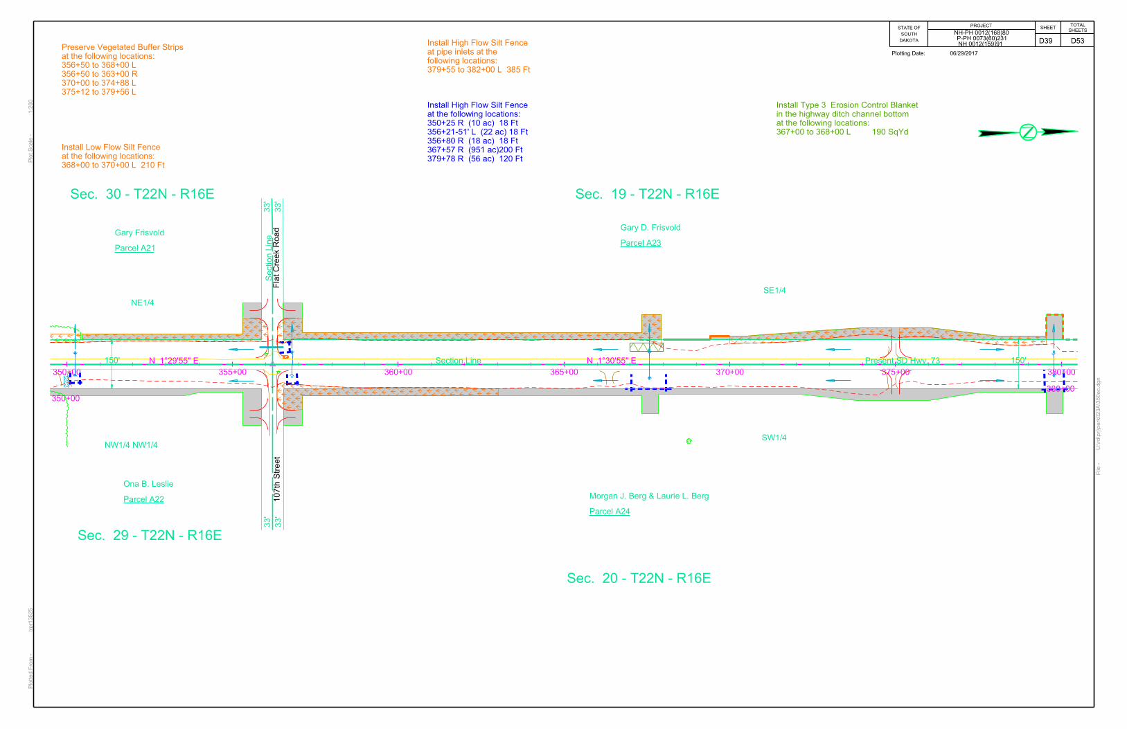
367+00 to 368+00 L 100 190
387+40 to 390+50 R 310 570
391+00 to 393+00 R 200 370
413+00 to 417+00 R 400 740
418+00 to 424+00 L 600 1,100
417+65 to 421+59 R 395 730
428+00 to 430+00 R 200 370
443+00 to 448+50 L 550 1,010
443+00 to 445+50 R 250 460
454+00 to 458+00 L 400 740
455+00 to 457+76 R 276 510
469+00 to 470+00 L 100 190
469+00 to 474+76 R 576 1,060
475+00 to 480+00 L 500 920
475+00 to 480+00 R 500 920
498+00 to 504+80 R 680 1,250
526+00 to 529+60 R 360 660
530+31 to 543+50 R 1,319 2,420
530+50 to 537+50 L 700 1,290
550+50 to 552+00 R 150 280
556+50 to 558+00 R 150 280
567+00 to 568+00 R 100 190
581+00 to 587+00 L 600 1,100
581+40 to 583+80 R 240 440
592+00 to 597+50 L 550 1,010
620+82 to 626+00 L 518 950
621+00 to 625+50 R 450 830
665+00 to 665+94 R 94 180
671+50 to 672+75 R 125 230
Total: 13,999 25,810
TABLE OF TYPE 3 EROSION CONTROL BLANKET PCN 02QB
Quantity
Stationing Shaping (Ft) (SqYd)
109+00 to 119+00 L 1,000 1,840
109+00 to 113+30 R 450 830
114+00 to 116+00 R 200 370
123+00 to 132+00 R 900 1,650
127+50 to 132+00 L 465 900
150+00 to 151+00 R 100 190
167+00 to 173+00 L 600 1,100
167+00 to 169+82 R 282 520
170+55 to 173+00 R 245 450
181+00 to 185+00 L 400 740
181+00 to 185+00 R 400 740
215+85 to 218+25 L 240 440
216+00 to 218+50 R 150 280
250+00 to 253+00 R 300 550
477+00 to 480+00 L 300 550
472+50 485+00 R 1,250 2,290
480+85 to 485+00 L 485 890
488+00 to 494+00 L 600 1,100
491+00 to 494+50 R 350 650
515+00 to 531+81 R 1,670 3,060
532+55 to 537+00 R 455 840
564+75 to 570+50 R 575 1,060
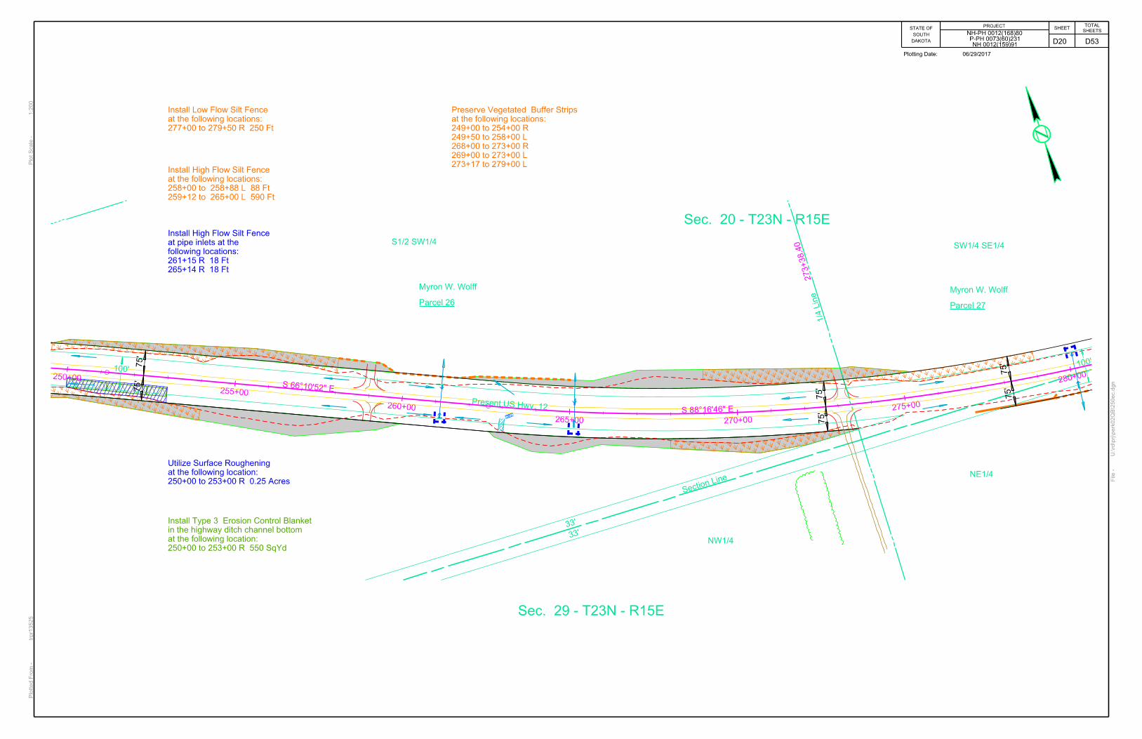
Total: 11,417 21,040 SHAPING FOR EROSION CONTROL BLANKET The ditches shall be shaped for the erosion control blanket as specified on Standard Plate 734.01. VEGETATED BUFFER STRIPS Vegetated buffer strips have been called out on plan sheets. The Contractor is to avoid disturbing existing vegetation in these areas. Preservation of these areas will help capture sediment and prevent erosion and runoff. No additional payment will be made for preserving vegetated buffer strips. SURFACE ROUGHENING Surface roughening shall be done within 14 days of soil disturbance unless the area will be worked or seeded within 21 days. Refer to Standard Plate 734.25 for details.
TABLE OF SURFACE ROUGHENING PCN 023A
Quantity
Stationing (Acres)
145+50 to 150+00 R 0.29
150+50 to 155+00 R 1.22
151+00 to 157+00 L 1.09
202+00 to 210+50 L 0.87
202+00 to 209+00 R 0.69
388+00 to 390+50 R 0.21
391+00 to 393+00 R 0.17
391+50 to 397+00 L 0.51
397+50 to 403+00 R 1.57
398+00 to 403+00 L 1.02
413+00 to 417+00 R 0.25
418+00 to 425+00 L 0.74
418+00 to 421+59 R 0.60
423+00 to 425+00 R 0.51
428+00 to 430+00 R 0.13
443+00 to 448+00 L 1.05
443+00 to 445+50 R 0.21
449+00 to 451+00 R 0.38
469+00 to 470+00 L 0.08
469+00 to 474+50 R 0.45
475+00 to 480+00 L 0.57
475+50 to 480+00 R 0.66
492+00 to 505+00 R 1.54
495+50 to 499+00 L 1.00
501+00 to 504+50 L 0.29
515+50 to 518+00 R 0.34
521+50 to 525+00 L 0.48
521+50 to 525+50 R 0.53
526+00 to 529+50 R 0.28
530+50 to 537+50 L 0.77
530+50 to 541+50 R 1.34
541+50 to 549+00 L 0.88
541+50 to 549+00 R 0.94
550+50 to 553+50 R 0.35
556+50 to 563+00 R 1.19
557+00 to 563+00 L 0.74
581+00 to 587+00 R 0.74
581+50 to 583+80 R 0.23
589+00 to 592+00 L 0.45
589+00 to 591+00 R 0.20
592+50 to 597+50 L 0.64
595+00 to 598+00 R 0.23
597+50 to 605+00 L 1.79
609+50 to 612+50 R 0.41
614+00 to 619+00 R 0.85
621+00 to 624+00 L 0.34
621+00 to 625+50 R 0.43
671+50 to 672+75 R 0.14
Total: 30.39
D4 D53
PROJECT STATE OF SOUTH
DAKOTA
NH-PH 0012(168)80 P-PH 0073(60)231 NH 0012(159)91
SHEET
TOTAL SHEETS
TABLE OF SURFACE ROUGHENING PCN 02QB
Quantity
Stationing (Acres)
65+00 to 70+00 L 0.37
65+00 to 70+00 R 0.48
98+00 to 112+00 L 3.39
98+00 to 131+50 L 5.00
109+00 to 131+00 R 2.45
150+00 to 155+00 L 0.37
150+00 to 155+00 R 0.39
157+50 to 162+00 L 1.07
158+00 to 162+00 R 0.65
167+00 to 174+00 L 0.54
167+00 to 169+50 R 0.25
171+00 to 175+50 R 0.33
181+00 to 185+00 L 0.81
181+00 to 185+00 R 0.31
194+50 to 200+00 L 1.17
195+00 to 200+00 R 0.71
215+85 to 218+25 L 0.30
216+00 to 218+50 R 0.21
250+00 to 253+00 R 0.25
344+50 to 352+00 R 1.12
439+50 to 446+00 L 1.5
473+00 to 485+00 R 2.17
477+00 to 480+41 L 0.33
485+00 to 490+00 L 0.69
505+00 to 513+00 L 1.94
505+00 to 508+50 R 0.39
515+00 to 531+50 R 5.89
532+55 to 537+00 R 0.39
564+50 to 570+50 R 0.6
565+00 to 568+00 L 0.36
Total: 34.43 LOW FLOW SILT FENCE
The low flow silt fence fabric provided shall be from the approved product list. The approved product list for low flow silt fence may be viewed at the following internet site:
http://sddot.com/business/certification/products/Default.aspx
Low flow silt fence shall be placed at the locations noted in the table and at locations that will minimize siltation of adjacent streams, lakes, dams, or drainage areas as determined by the Engineer during construction. Refer to Standard Plate 734.04 for details.
An additional quantity of Low Flow Silt Fence has been added to the Estimate of Quantities for temporary sediment control.
TABLE OF LOW FLOW SILT FENCE PCN 023A
Quantity
Stationing (Feet)
264+50 to 274+00 L 950
266+00 to 276+84 R 1,130
277+10 to 285+00 R 835
285+50 (TBD) Box Culverts 1,000
320+30 to 325+22 L 495
368+00 to 370+00 L 210
387+12 to 390+24 L 340
391+30 to 397+05 L 600
393+00 to 396+00 R 320
403+00 to 406+60 L 380
403+00 to 407+50 R 470
407+50 to 409+00 R 235
414+00 to 417+49 L 370
429+00 to 430+32 L 305
431+57 to 434+27 L 270
436+00 to 439+50 R 350
445+50 to 446+50 R 105
452+00 to 455+00 R 305
470+15 to 475+00 L 500
480+00 to 482+25 L 230
480+00 to 482+25 R 230
486+00 to 492+00 R 610
486+50 to 493+00 L 665
500+80 to 503+36 L 265
518+50 to 521+50 R 300
526+50 to 529+73 L 330
537+00 to 541+56 L 465
549+00 to 553+50 R 445
556+00 to 557+50 L 160
563+00 to 565+00 L 210
563+44 to 567+40 R 475
586+50 to 588+50 L 200
593+00 to 598+60 R 570
603+00 to 604+50 R 150
605+00 to 612+00 L 700
614+00 to 618+00 L 400
626+00 to 627+00 L 395
654+80 (TBD) Box Culverts 1,000
Subtotal: 16,970
Additional Quantity: 1,730
Total: 18,700
TABLE OF LOW FLOW SILT FENCE PCN 02QB
Quantity
Stationing (Feet)
59+00 to 67+00 L 1,000
64+50 to 66+00 R 165
85+00 to 86+25 L 125
85+00 to 86+50 R 44
87+00 to 95+00 L 800
87+50 to 98+00 R 1,050
105+00 to 110+50 R 565
112+83 to 115+23 R 300
118+94 to 121+84 L 246
175+50 L Box Culvert 200
176+00 L Box Culvert 200
176+50 to 180+00 R 350
191+00 to 193+00 R 200
224+00 to 229+00 R 500
225+00 to 231+00 L 605
233+00 to 234+00 L 100
233+00 to 235+00 R 200
277+00 to 279+50 R 250
281+00 to 284+50 R 350
286+35 to 286+56 R 21
286+80 to 286+99 R 19
323+00 to 326+00 L 117
327+50 to 343+00 L 1730
381+00 to 384+00 R 300
381+50 to 386+50 L 525
434+00 to 440+00 R 600
495+00 to 500+00 R 515
495+50 to 500+00 L 440
Subtotal: 11,517
Additional Quantity: 283
Total: 11,800
D5 D53
PROJECT STATE OF SOUTH
DAKOTA
NH-PH 0012(168)80 P-PH 0073(60)231 NH 0012(159)91
SHEET
TOTAL SHEETS
HIGH FLOW SILT FENCE
The high flow silt fence fabric provided shall be from the approved product list. The approved product list for high flow silt fence may be viewed at the following internet site:
http://sddot.com/business/certification/products/Default.aspx
High flow silt fence shall be placed at the locations noted in the table and at locations that will minimize siltation of adjacent streams, lakes, dams, or drainage areas as determined by the Engineer during construction. Refer to Standard Plate 734.05 for details.
An additional quantity of high flow silt fence has been added to the Estimate of Quantities for temporary sediment control. TABLE OF HIGH FLOW SILT FENCE PCN 023A
Quantity
Stationing (Feet)
116+25 R 40
116+50 R 40
116+75 R 40
117+48 L (35 ac) 18
130+71 L (101 ac) 200
145+44 R (6 ac) 18
149+87 to 150+73 L 170
150+45 R (1 ac) 18
159+00 to 165+31 R 640
160+27 L (261 ac) 200
171+27-51' L 18
171+27-51' R 18
176+30 L (6 ac) 18
182+80 L (23 ac) 18
182+55 to 183+05 R 50
197+36 to 197+54 R 18
197+89 to 199+69 R 261
199+00 to 201+00 L 200
206+41 R (3 ac) 18
223+00 to 225+50 R 250
224+14-51' L (18 ac) 18
225+26 L (67 ac) 120
235+38 to 238+70 R 332
239+26 L (44 ac) 18
244+40 L (16 ac) 18
251+13 L (77 ac) 18
264+50 to 266+00 R 150
265+90 L (52 ac) 120
276+96-51' L 18
283+00 to 287+50 L 500
285+00 to 287+00 R 315
287+09-51' R 30
304+72 to 306+00 L 380
304+00 R Across Ditch 40
304+30 R Across Ditch 40
304+50 R Across Ditch 40
304+70 R Across Ditch 40
313+11 R (11 ac) 18
317+23 R (56 ac) 120
329+80-51' L 18
330+34 R 18
336+86 R (11 ac) 30
341+04 R (814 ac) 200
346+05-51' R (6 ac) 18
350+25 R (10 ac) 18
356+21-51' L (22 ac) 18
356+80 R (18 ac) 18
367+57 R (951 ac) 200
379+55 to 382+00 L 385
379+78 R (56 ac) 120
387+00-51' R (44 ac) 30
390+20 to 391+30 L 150
391+00 R (1 ac) 18
397+05 to 397+55 L 155
397+31 R (1 ac) 18
406+55 to 409+00 L 240
408+00 R (36 ac) 30
409+21 to 411+50 L 382
410+20 R (29 ac) 30
417+49 to 417+96 L 195
417+78 R (2 ac) 18
422+00-51' R 18
428+13 R (44 ac) 30
428+41 to 429+00 L 60
437+00 to 439+50 L 250
438+06 R (15 ac) 18
446+50 to 448+50 R 200
448+26 R (88 ac) 120
448+50 to 449+50 L 100
451+50 to 453+00 L 160
452+25 R (719 ac) 200
458+16-51' R 18
463+50 to 465+50 R 200
465+07 L (41 ac) 30
475+22 R (2 ac) 18
482+50-51' R 18
499+22 L (2 ac) 18
503+18 to 505+00 L 237
504+75 R (79 ac) 120
506+50 to 509+00 L 250
507+47 R (49 ac) 30
517+00 to 520+50 L 350
520+18 R (163 ac) 200
525+00 to 526+50 L 300
526+06 R (7 ac) 18
530+00-51'R 18
553+50 to 556+00 L 250
554+84 R (40 ac) 30
565+00 to 567+40 L 290
565+99 R (23 ac) 18
577+15 R (20 ac) 18
580+99-51' R 18
584+00 to 588+50 R 460
587+11 L (93 ac) 120
591+00 to 593+00 R 205
592+33 L (12 ac) 18
612+00 to 614+00 L 200
613+12 R (2 ac) 18
620+40-51' L 18
625+39 L (527 ac) 200
625+50 to 633+50 R 800
632+11 L (85 ac) 120
634+00-47' L 18
634+00-49' R 18
638+00-51' R 18
641+84-51' L 18
648+50-51' L 18
653+25 to 661+50 R 825
654+50 to 656+00 L 150
661+88-51' L 18
661+78-51' R (7 ac) 18
666+42-51' R 18
671+50 R (5 ac) 18
Subtotal: 13,798
Additional Quantity: 902
Total: 14,700
D6 D53
PROJECT STATE OF SOUTH
DAKOTA
NH-PH 0012(168)80 P-PH 0073(60)231 NH 0012(159)91
SHEET
TOTAL SHEETS
TABLE OF HIGH FLOW SILT FENCE PCN 02QB
Quantity
Stationing (Feet)
30+00 to 32+50 R 250
31+85 L 18
51+20 L 120
62+00 to 64+50 60
70+50 to 71+50 L 40
71+00-51’ R 18
79+00-51’ R 18
86+60-51’ R 18
87+03-51’ R 18
90+20 R 18
105+19 L 18
112+70 L 18
118+94 to 120+00 R 115
119+40 L 18
125+19 R 18
151+50 to 154+00 R 250
152+17 L 30
170+15-51’ R 18
174+00 to 177+00 L 315
174+95 to 176+50 R 155
188+00 to 191+00 R 300
189+15 L 18
194+70 L 18
200+00 to 201+50 L 150
200+61 R 30
218+67-51' L 18
223+00 to 225+00 L 200
224+15 R 18
231+00 to 233+00 L 200
232+20 R 18
241+00 to 244+50 L 355
243+15 R 30
245+25 to 249+50 L 430
258+00 to 258+88 L 88
259+12 to 265+00 590
261+15 R 18
265+14 R 18
279+50 to 281+00 R 150
280+14 L 18
289+50 to 290+80 R 130
290+13 L 18
311+98 L 18
326+27-51' L 18
327+50 to 341+00 L 1,530
333+61 L (226 ac) 200
346+00-51'L 18
356+11 L 18
360+00-47' L 18
386+09 L 30
413+38 L 30
431+84-51' L 18
431+84-51' R 18
52+50 to 456+50 R 400
455+08 R 18
458+24 R &Ah 18
462+11-51'L 18
470+00 to 474+00 L 400
472+56 R 30
485+00 to 486+40 L 345
486+08 R 18
489+83 to 490+35 R 130
490+59 L 18
504+12-51' L 18
504+12-51' R 18
508+50 to 509+50 R 125
508+67 L 18
514+08 R 30
520+34 R 18
532+16-51' R 18
537+00 to 546+00 L 900
537+00 to 543+50 R 685
542+62 L (643 ac) 200
556+00 to 561+50 R 590
556+86 L 30
563+94-150' L 18
564+29-57'L (25 ac) 18
564+62-150' L &Ah (11 ac) 18
568+78-57' L 18
570+70-51' L 18
Subtotal: 10,399
Additional Quantity: 2,101
Total: 12,500 CONSTRUCTION ENTRANCE
The Contractor shall install a Construction Entrance at locations where there is a potential for mud tracking and sediment flow from the construction site and work area onto a paved public roadway.
It is the Contractor’s option to use the SDDOT Construction Entrance (See SDDOT Construction Entrance notes and details), a product from the list provided in these notes, or other products or processes as approved by the Engineer during construction.
If the Contractor elects to use one of the products listed in the table, then the Contractor shall install the construction entrance product in accordance with the manufacturer’s installation instructions or as directed by the Engineer.
The Contractor shall maintain the construction entrance such that mud tracking and sediment flow will not enter the roadway or adjacent drainage areas. The construction entrance shall be routinely inspected and the Contractor shall repair or replace material as deemed necessary by the Engineer.
All costs for furnishing, installing, maintaining, and removal of the construction entrance including equipment, labor, materials, and incidentals shall be included in the contract unit price per each for “Construction Entrance”.
The following table is a list of known construction entrance products available for use:
Product Manufacturer
Grizzly Rumble Grate (10’ width and 24’ length required)
Trackout Control, LLC Tempe, AZ Phone: 1-800-761-0056 www.trackoutcontrol.com
Rumble Grid (12’ width and 24’ length including combination of grids and ramps
required)
Pro-Tec Equipment, Inc. Charlotte, MI Phone: 1-800-292-1225 www.pro-tecequipment.com
Tracking Pad (12’ width and 24’ length
(2 – 12’x12’ pads) and 2 – 4’x4’ turning flares)
Tracking Pads LLC Denver, CO Phone: 1-719-371-3791 www.trackingpads.com
SDDOT CONSTRUCTION ENTRANCE
If the SDDOT Construction Entrance is utilized, then the Contractor shall install the SDDOT Construction Entrance in accordance with these notes and the detail drawings.
Pit run material shall be obtained from a granular source and shall conform to the following gradation:
Sieve Size Percent Passing
6” 100%
#4 0-60%
#200 0-20%
The pit run material shall be compacted to the satisfaction of the Engineer.
The aggregate for the granular material shall conform to the following gradation requirements:
Sieve Size Percent Passing
3” 100%
2 ½” 90-100%
1 ½” 25-60%
¾” 0-10%
½” 0-5%
The granular material shall be placed in 6” maximum lifts.
It is anticipated that the granular material will need to be periodically removed and replaced as it becomes inundated with mud and sediment.
The reinforcement fabric (MSE) shall conform to Section 831 of the Specifications. The MSE geotextile shall be on the Approved Products List for this material or will be certified by the supplier to meet this specification prior to installation.
The reinforcement fabric (MSE) should be kept as taut as possible prior to placing.
Equipment shall not be allowed on the reinforcement fabric (MSE) until the first lift of granular material is in place.
All seams in the reinforcement fabric (MSE) shall be overlapped at least 2’ and shingled.
D7 D53
PROJECT STATE OF SOUTH
DAKOTA
NH-PH 0012(168)80 P-PH 0073(60)231 NH 0012(159)91
SHEET
TOTAL SHEETS
STORM WATER POLLUTION PREVENTION PLAN CHECKLIST (The numbers right of the title headings are reference numbers to the GENERAL PERMIT FOR STORM WATER DISCHARGES ASSOCIATED WITH CONSTRUCTION ACTIVITIES
SITE DESCRIPTION (4.2 1)
� Project Limits: See Title Sheet (4.2 1.b) � Project Description: See Title Sheet (4.2 1.a.) � Site Map(s): See Title Sheet and Plans (4.2 1.f. (1)-(6)) � Major Soil Disturbing Activities (check all that apply)
� Clearing and grubbing � Excavation/borrow � Grading and shaping � Filling � Cutting and filling � Other (describe):
� Total Project Area 02QB-248 Acres, 023A-233 Acres (4.2 1.b.) � Total Area To Be Disturbed 02QB-185 Acres, 023A-233 Acres � Existing Vegetative Cover (%) � Soil: clay sand, sandy clay, silty clay, silty sand, clay silt, gravel, sand � Name of Receiving Water: 02QB-Flat Creek, 023A-East Flat Creek
ORDER OF CONSTRUCTION ACTIVITIES (4.2 1.c.)
(Stabilization measures shall be initiated as soon as possible, but in no case later than 14 days after the construction activity in that portion of the site has temporarily or permanently ceased. Initiation of final or temporary stabilization may exceed the 14-day limit if earth disturbing activities will be resumed within 21 days.)
� Special sequencing requirements (see Section C). � Install stabilized construction entrance(s). � Install low flow silt fence or erosion control wattles on contour
where runoff sheets from the site. � Clearing and grubbing. � Remove and store topsoil. � Stabilize disturbed areas that will not be permanently seeded or
worked within 14 days of disturbance by cover crop seeding, mulching, soil stabilizer, or completing surface roughening.
� Install inlet protection around new inlets and existing inlets that outlet offsite and aren’t being immediately removed.
� Complete final grading. � Complete final paving and sealing of concrete. � Complete traffic control installation and protection devices. � Reseed areas disturbed by removal activities as soon as
possible, mulch areas not already mulched or cover with Erosion Control Blanket.
EROSION AND SEDIMENT CONTROLS (4.2 2.a.(1)(a)-(f)) � Stabilization Practices (See Detail Plan Sheets)
� Temporary Seeding (Cover Crop Seeding) � Permanent Seeding � Sodding � Planting (Woody Vegetation for Soil Stabilization) � Mulching (Grass Hay or Straw) � Hydraulic Straw Mulch � Soil Stabilizer � Bonded Fiber Matrix � Erosion Control Blankets � Vegetation Buffer Strips � Roughened Surface (e.g. tracking) � Dust Control (See Section F – Surfacing Plans) � Other:
� Structural Temporary Erosion and Sediment Controls � Silt Fence � Floating Silt Curtain � Straw Bale Check � Temporary Berm � Temporary Slope Drain � Straw Wattles or Rolls � Turf Reinforcement Mat � Rip Rap � Gabions � Rock Check Dams � Sediment Traps/Basins � Inlet Protection � Outlet Protection � Surface Inlet Protection (Area Drain) � Curb Inlet Protection � Stabilized Construction Entrances � Entrance/Exit Equipment Tire Wash � Interceptor Ditch � Concrete Washout Facility (as required by spec book) � Temporary Diversion Channel � Work Platform � Temporary Water Barrier � Temporary Water Crossing (Temporary Diversion) � Other:
� Storm Water Management (4.2 2.b., (1) and (2)) Storm water management will be handled by temporary controls outlined in “EROSION AND SEDIMENT CONTROLS” above, and any permanent controls needed to meet permanent storm water management needs in the post construction period. Permanent controls will be shown on the plans and noted as permanent.
� Wetland Avoidance Will construction and/or erosion and sediment controls impinge on regulated wetlands? Yes No If yes, the structural and erosion and sediment controls have been included in the total project wetland impacts and have been included in the 404 permit process with the USACE.
� Other Storm Water Controls (4.2 2.c., (1) and (2)) � Waste Disposal
All liquid waste materials will be collected and stored in sealed metal containers approved by the project engineer. All trash and construction debris from the site will be deposited in the approved containers. Containers will be serviced as necessary, and the trash will be hauled to an approved disposal site or licensed landfill. All onsite personnel will be instructed in the proper procedures for waste disposal, and notices stating proper practices will be posted in the field office. The general Contractor’s representative responsible for the conduct of work on the site will be responsible for seeing waste disposal procedures are followed.
� Hazardous Waste All hazardous waste materials will be disposed of in a manner specified by local or state regulations or by the manufacturer. Site personnel will be instructed in these practices, and the individual designated as the Contractor’s on-site representative will be responsible for seeing that these practices are followed.
� Sanitary Waste Portable sanitary facilities will be provided on all construction sites. Sanitary waste will be collected from the portable units in a timely manner by a licensed waste management Contractor or as required by any local regulations.
Revised 07/19/2017 MLD
MAINTENANCE AND INSPECTION (4.2 3. and 4.2 4.) � Maintenance and Inspection Practices
� Inspections will be conducted at least one time per week and after a storm event of 0.50 inches or greater.
� All controls will be maintained in good working order. Necessary repairs will be initiated within 24 hours of the site inspection report.
� Silt fence will be inspected for depth of sediment and for tears in order to ensure the fabric is securely attached to the posts and that the posts are well anchored. Sediment buildup will be removed from the silt fence when it reaches
1/3 of the height of
the silt fence. � Sediment basins and traps will be checked. Sediment will be
removed when depth reaches approximately 50 percent of the structure’s capacity, and at the conclusion of the construction.
� Check dams will be inspected for stability. Sediment will be removed when depth reaches ½ the height of the dam.
� All seeded areas will be checked for bare spots, washouts, and vigorous growth free of significant weed infestations.
� Inspection and maintenance reports will be prepared on form DOT 298 for each site inspection, this form will also be used to document changes to the SWPPP. A copy of the completed inspection form will be filed with the SWPPP documents.
� The SDDOT Project Engineer and Contractor’s Erosion Control Supervisor are responsible for inspections. Maintenance, repair activities are the responsibility of the Contractor. The SDDOT Project Engineer will complete the inspection and maintenance reports and distribute copies per the distribution instructions on DOT 298.
MATERIALS INVENTORY (4.2. 2.c.(2)) The following materials or substances are expected to be present on the site during the construction period. These materials will be handled as noted under the headings “EROSION AND SEDIMENT CONTROLS” and “SPILL PREVENTION” (check all that apply). � Concrete and Portland Cement � Detergents � Paints � Metals � Bituminous Materials � Petroleum Based Products � Cleaning Solvents � Wood � Cure � Texture � Chemical Fertilizers � Other:
NON-STORM WATER DISCHARGES (3.0) The following non-storm water discharges are anticipated during the course of this project (check all that apply). � Discharges from water line flushing. � Pavement wash-water, where no spills or leaks of toxic or
hazardous materials have occurred. � Uncontaminated ground water associated with dewatering
activities.
D8 D53
PROJECT STATE OF SOUTH
DAKOTA
NH-PH 0012(168)80 P-PH 0073(60)231 NH 0012(159)91
SHEET
TOTAL SHEETS
SPILL PREVENTION (4.2 2.c.(2)) � Material Management
� Housekeeping
• Only needed products will be stored on-site by the Contractor.
• Except for bulk materials the contractor will store all materials under cover and in appropriate containers.
• Products must be stored in original containers and labeled.
• Material mixing will be conducted in accordance with the manufacturer’s recommendations.
• When possible, all products will be completely used before properly disposing of the container off-site.
• The manufacturer’s directions for disposal of materials and containers will be followed.
• The Contractor’s site superintendent will inspect materials storage areas regularly to ensure proper use and disposal.
• Dust generated will be controlled in an environmentally safe manner.
• Vegetation areas not essential to the construction project will be preserved and maintained as noted on the plans.
� Hazardous Materials
• Products will be kept in original containers unless the container is not resealable.
• Original labels and material safety data sheets will be retained in a safe place to relay important product information.
• If surplus product must be disposed of, manufacturer’s label directions for disposal will be followed.
• Maintenance and repair of all equipment and vehicles involving oil changes, hydraulic system drain down, de-greasing operations, fuel tank drain down and removal, and other activities which may result in the accidental release of contaminants will be conducted on an impervious surface and under cover during wet weather to prevent the release of contaminants onto the ground.
• Wheel wash water will be collected and allowed to settle out suspended solids prior to discharge. Wheel wash water will not be discharged directly into any storm water system or storm water treatment system.
• Potential pH-modifying materials such as: bulk cement, cement kiln dust, fly ash, new concrete washings, concrete pumping, residuals from concrete saw cutting (either wet or dry), and mixer washout waters will be collected on site and managed to prevent contamination of storm water runoff.
� Product Specific Practices (6.8) � Petroleum Products
All on-site vehicles will be monitored for leaks and receive regular preventive maintenance to reduce the chance of leakage. Petroleum products will be stored in tightly sealed containers which are clearly labeled.
� Fertilizers Fertilizers will be applied only in the amounts specified by the SDDOT. Once applied, fertilizers will be worked into the soil to limit the exposure to storm water. Fertilizers will be stored in an enclosed area. The contents of partially used fertilizer bags will be transferred to sealable containers to avoid spills.
� Paints All containers will be tightly sealed and stored when not required for use. The excess will be disposed of according to the manufacturer’s instructions and any applicable state and local regulations.
� Concrete Trucks
Contractors will provide designated truck washout facilities on the site. These areas must be self-contained and not connected to any storm water outlet of the site. Upon completion of construction, the area at the washout facility will be properly stabilized.
� Spill Control Practices (4.2 2 c.(2)) In addition to the previous housekeeping and management practices, the following practices will be followed for spill prevention and cleanup if needed. � For all hazardous materials stored on site, the manufacturer’s
recommended methods for spill cleanup will be clearly posted. Site personnel will be made aware of the procedures and the locations of the information and cleanup supplies.
� Appropriate cleanup materials and equipment will be maintained by the Contractor in the materials storage area on-site. As appropriate, equipment and materials may include items such as brooms, dust pans, mops, rags, gloves, goggles, kitty litter, sand, sawdust, and plastic and metal trash containers specifically for cleanup purposes.
� All spills will be cleaned immediately after discovery and the materials disposed of properly.
� The spill area will be kept well ventilated and personnel will wear appropriate protective clothing to prevent injury from contact with a hazardous substance.
� After a spill a report will be prepared describing the spill, what caused it, and the cleanup measures taken. The spill prevention plan will be adjusted to include measures to prevent this type of spill from reoccurring, as well as clean up instructions in the event of reoccurrences.
� The Contractor’s site superintendent, responsible for day-to-day operations, will be the spill prevention and cleanup coordinator. The Contractor is responsible for ensuring that the site superintendent has had appropriate training for hazardous materials handling, spill management, and cleanup.
� Spill Response (4.2 2 c.(2)) The primary objective in responding to a spill is to quickly contain the material(s) and prevent or minimize migration into storm water runoff and conveyance systems. If the release has impacted on-site storm water, it is critical to contain the released materials on-site and prevent their release into receiving waters. If a spill of pollutants threatens storm water or surface water at the site, the spill response procedures outlined below must be implemented in a timely manner to prevent the release of pollutants. � The Contractor’s site superintendent will be notified immediately
when a spill or the threat of a spill is observed. The superintendent will assess the situation and determine the appropriate response.
� If spills represent an imminent threat of escaping erosion and sediment controls and entering receiving waters, personnel will be directed to respond immediately to contain the release and notify the superintendent after the situation has been stabilized.
� Spill kits containing appropriate materials and equipment for spill response and cleanup will be maintained by the Contractor at the site.
� If oil sheen is observed on surface water (e.g. settling ponds, detention ponds, swales), action will be taken immediately to remove the material causing the sheen. The Contractor will use appropriate materials to contain and absorb the spill. The source of the oil sheen will also be identified and removed or repaired as necessary to prevent further releases.
� If a spill occurs the superintendent or the superintendent’s designee will be responsible for completing the spill reporting form and for reporting the spill to SD DENR.
� Personnel with primary responsibility for spill response and clean up will receive training by the Contractor’s site superintendent or designee. The training must include identifying the location of the spill kits and other spill response equipment and the use of spill response materials.
� Spill response equipment will be inspected and maintained as necessary to replace any materials used in spill response activities.
SPILL NOTIFICATION In the event of a spill, the Contractor’s site superintendent will make the appropriate notification(s), consistent with the following procedures: � A release or spill of a regulated substance (includes petroleum and
petroleum products) must be reported to DENR immediately if any one of the following conditions exists: � The discharge threatens or is in a position to threaten the waters
of the state (surface water or ground water). � The discharge causes an immediate danger to human health or
safety. � The discharge exceeds 25 gallons. � The discharge causes a sheen on surface water. � The discharge of any substance that exceeds the ground water
quality standards of ARSD (Administrative Rules of South Dakota) chapter 74:51:01.
� The discharge of any substance that exceeds the surface water quality standards of ARSD chapter 74:51:01.
� The discharge of any substance that harms or threatens to harm wildlife or aquatic life.
� The discharge of crude oil in field activities under SDCL (South Dakota Codified Laws) chapter 45-9 is greater than 1 barrel (42 gallons).
To report a release or spill, call DENR at 605-773-3296 during regular office hours (8 a.m. to 5 p.m. Central time). To report the release after hours, on weekends or holidays, call State Radio Communications at 605-773-3231. Reporting the release to DENR does not meet any obligation for reporting to other state, local, or federal agencies. Therefore, the responsible person must also contact local authorities to determine the local reporting requirements for releases. DENR recommends that spills also be reported to the National Response Center at (800) 424-8802.
CONSTRUCTION CHANGES (4.4) When changes are made to the construction project that will require alterations in the temporary erosion controls of the site, the Storm Water Pollution Prevention Plan (SWPPP) will be amended to provide appropriate protection to disturbed areas, all storm water structures, and adjacent waters. The SDDOT Project Engineer will modify the SWPPP plan (DOT 298) and drawings to reflect the needed changes. Copies of changes will be routed per DOT 298. Copies of forms and the SWPPP will be retained in a designated place for review over the course of the project.
D9 D53
PROJECT STATE OF SOUTH
DAKOTA
NH-PH 0012(168)80 P-PH 0073(60)231 NH 0012(159)91
SHEET
TOTAL SHEETS
CERTIFICATIONS
� Certification of Compliance with Federal, State, and Local
Regulations The Storm Water Pollution Prevention Plan (SWPPP) for this project reflects the requirements of all local municipal jurisdictions for storm water management and sediment and erosion control as established by ordinance, as well as other state and federal requirements for sediment and erosion control plans, permits, notices or documentation as appropriate.
� South Dakota Department of Transportation
I certify under penalty of law that this document and all attachments were prepared under my direction or supervision in accordance with a system designed to assure that qualified personnel properly gather and evaluate the information submitted. Based on my inquiry of the person or persons who manage the system, or those persons directly responsible for gathering the information, the information submitted is, to the best of my knowledge and belief, true, accurate, and complete. I am aware that there are significant penalties for submitting false information, including the possibility of fine and imprisonment for knowing violations.
Authorized Signature (See the General Permit, Section 6.9.1.C.)
� Prime Contractor This section is to be executed by the General Contractor after the award of the contract. This section may be executed any time there is a change in the Prime Contractor of the project.
I certify under penalty of law that this document and all attachments will be revised or maintained under my direction or supervision in accordance with a system designed to assure that qualified personnel properly gather and evaluate the information submitted. Based on my inquiry of the person or persons who manage the system, or those persons directly responsible for gathering the information, the information submitted is, to the best of my knowledge and belief, true, accurate, and complete. I am aware that there are significant penalties for submitting false information, including the possibility of fine and imprisonment for knowing violations.
_________________________________________________________
Authorized Signature
CONTACT INFORMATION
� Contractor Information:
� Prime Contractor Name: ______________________________
� Contractor Contact Name: _____________________________
� Address: _____________________________
� _____________________________________
� City: ____________________State: _________Zip: _________
� Office Phone: _________________Field: __________________
� Cell Phone: ___________________Fax: ___________________
� Erosion Control Supervisor
� Name: ______________________________
� Address: _____________________________
� _____________________________________
� City: ____________________State: _________Zip: _________
� Office Phone: _________________Field: __________________
� Cell Phone: ___________________Fax: ___________________
� SDDOT Project Engineer
� Name: ______________________________
� Business Address: _____________________________
� Job Office Location: _____________________________
� City: ____________________State: _________Zip: _________
� Office Phone: _________________Field: __________________
� Cell Phone: ___________________Fax: ___________________
� SD DENR Contact Spill Reporting � Business Hours Monday-Friday (605) 773-3296 � Nights and Weekends (605) 773-3231
� SD DENR Contact for Hazardous Materials. � (605) 773-3153
� National Response Center Hotline � (800) 424-8802.
D10 D53
DAKOTA
SOUTH
STATE OFPROJECT
SHEETSHEETS
TOTAL
NH-PH 0012(168)80P-PH 0073(60)231NH 0012(159)91
Low Flow Silt Fence
High Flow Silt Fence
High Flow Silt Fence at Pipe
Temporary Sediment Barrier
Temporary Water Barrier
Floating Silt Curtain
Sediment Filter Bags
Triangular Silt Barriers
Erosion Control Wattles on Slopes
Erosion Control Wattles at Inlets
Erosion Control Wattles in Ditches
Erosion Bales
Surfacing Roughening
Type 2 Erosion Control Blanket
Type 3 Erosion Control Blanket
Type 4 Erosion Control Blanket
Type 1 Turf Reinforcement Mat
Type 2 Turf Reinforcement Mat
Type 3 Turf Reinforcement Mat
Transition Mat
Rock Check Dam
Temporary Slope Drain
Topsoil Stockpile
Borrow Area
Stabilized Construction Entrance
Concrete Washout
Asphalt Plant Site
Concrete Plant Site
Vehicle and Equipment Parking, Fueling, and Maintenance Areas
Dumpster or other Trash and Debris Containers
On-Site Construction Material Storage Area
Spill Kit
Work Platform
Cut Interceptor Ditch
If these items are applicable they are to be shown in the updated SWPPP using the Symbols given.
Best Management Practices (BMPs) are split into three categories and are to be used throughout construction.
Bonded Fiber Matrix/ Fiber Reinforced Matrix
Temporary Grass Hay or Straw Mulch/ Soil Stabilizer
Type 1 Erosion Control Blanket
BEST MANAGEMENT PRACTICES
and in the Final Phase to achieve final stabilization.
in the Initial Phase prior to earth disturbing activitIes and remain in place for the Intermediate Phase for temporary stabilization
BMPs from the Legend shown as Orange Symbols on the Erosion and Sediment Control Plan Sheets are to be installed
INITIAL PHASE
Intermediate Phase for temporary stabilization and remain in place in the Final Phase to achieve final stabilization.
BMPs from the Legend shown as Blue Symbols on the Erosion and Sediment Control Plan Sheets are to be installed in the
INTERMEDIATE PHASE
Final Phase to achieve final stabilization.
BMPs from the Legend shown as Green Symbols on the Erosion and Sediment Control Plan Sheets are to be installed in the
FINAL PHASE
Sediment Control at Inlet After Placement of Surfacing
Sediment Control at Inlet Before Placement of Surfacing
Silt Trap (See Standard Plate 734.04)
Vegetated Buffer Strip
...\rd\prj\p
erk
02
QB\E
&S
CLegend.d
gn
File -
Plotting Date: 06/29/2017
Plot Scale -
1:2
00
Plotted Fro
m -
trpr1
3525
TS
B
CE
M
SK
WP
CW
AP
CP
V
D
EROSION AND SEDIMENT CONTROL LEGEND D11 D53
SHEETS
TOTALPROJECT
DAKOTA
SOUTH
STATE OF SHEET
NH-PH 0012(168)80P-PH 0073(60)231 NH 0012(159)91
10+00 40+00
35+00
30+00
25+00
20+0015+00
U:\rd\prj\p
erk
02
QB\0
10ec.d
gn
File -
Plotting Date: 06/29/2017
Plot Scale -
1:2
00
Plotted Fro
m -
trpr1
3525
Begin NH-PH 0012(168)80Station 18+00
33’
Parcel 1
James A. Perea & Wendy S. Perea
State Line
Section Line 3
3’
33’
Government Lot 4Government Lot 1NORTH DAKOTA
SOUTH DAKOTA
33’
Sec. 21 - T23N - R14E
200’ 100’
100’
200’
Present US Hwy. 12
Section Line
32+51.2
2
19+24.5
3
33’
33’
Government Lot 2
1/4 Line
Sec. 22 - T23N - R14E
75’
75’
75’
75’
250 Ft30+00 to 32+50 R
at the following location:
for Perimeter Protection
Install High Flow Silt Fence
31+85 L Pipe Inlet 18 Ft
at the following location:
Install High Flow Silt Fence
D12 D53
40+0070+00
DAKOTA
SOUTH
STATE OFPROJECT
SHEETSHEETS
TOTAL
NH-PH 0012(168)80P-PH 0073(60)231NH 0012(159)91
40+0045+00
50+0055+00
60+00 65+00
70+00
U:\rd\prj\p
erk
02
QB\0
40ec.d
gn
File -
Plotting Date: 06/29/2017
Plot Scale -
1:2
00
Plotted Fro
m -
trpr1
3525
Government Lot 4
1/4 Line
Sec. 22 - T23N - R14E
Government Lot 3
1/4 Line
Government Lot 2
Sec. 22 - T23N - R14E
div63
Present US Hwy. 12
100’ 100’
Parcel 2
James A. Perea & Wendy S. Perea
Parcel 1
James A. Perea & Wendy S. Perea
Parcel A1
James A. Perea & Wendy S. Perea
Parcels 3 & 4
Kenneth Zentner & Lucinda Zentner
45+80.6
2
59+10.9
7
65+81.78
N1/2 SE1/4
SW1/4
51+20 L Pipe Inlet 120 Ft
at the following locations:
Install High Flow Silt Fence
0.48 Acres65+00 to 70+00 R
0.37 Acres65+00 to 70+00 L
at the following locations:
Utilize Surface Roughening
165 Ft64+50 to 66+00 R
1,000 Ft59+00 to 67+00 L
at the following locations:
Install Low Flow Silt Fence
60 Ft62+00 to 64+50 R
at the following locations:
Install High Flow Silt Fence
75’
75’
75’
75’
D13 D53
DAKOTA
SOUTH
STATE OFPROJECT
SHEETSHEETS
TOTAL
NH-PH 0012(168)80P-PH 0073(60)231NH 0012(159)91
70+0075+00 80+00 85+00 90+00 95+00 100+00
66’
66’ 1/16 Line
1/1
6 Line
1/64 Line
Sec. 23 - T23N - R14E
BLOCK 16
3
Alley
20’
Second A
venue E
ast
66’
12
6
5
4
First
Avenue E
ast
Fourt
h Stre
et
10
7
8
9
Third Street
BLOCK 9
Alley
6
5
4
3
2
66’
1
20’
Sec. 22 - T23N - R14E
Section Line
50’
Third
Street
First
Avenue W
est
Second A
venue W
est
Third A
venue W
est
Secon
d Stre
et
66’
66’
66’
66’
66’
66’
BLOCK 12
BLOCK 13BLOCK 14
BLOCK 18
BLOCK 19
Alley
Alley
Alley
20’
20’
20’
20’
BLOCK 11
1/4 Lin
e
Government Lot 1
First Stre
et
Second A
venue W
est
FIRST
ADDITION
66’ BLOCK 5
BLOCK 17
Alley
Alley
20’
20’
66’
66’
12
Main Street
50’
50’
Secon
d Stre
et
66’
BLOCK 6
BLOCK 7
BLOCK 11
Alley
20’
66’
Alley
20’
11
10
1
2
3
45
12
11
10
9
8
7
1
2
3
4
5
6
18
17
16
15
14
13
1
2
3
4
5
6
7
8
9
10
11
12
18
17
16
15
14
13
12
11
10
9
8
7
1
2
3
45
18
17
16
15
14
13
12
7
12
11
10
9
8
7
6
5
4
3
2
1
12
1
2
10
11
12
1
2
3
4
13
14
15
16
17
18
1
2
3
4
5
6
7
8
9
10
11
12
11
10
9
8
7
6
5
4
3
13
14
12
11
101512 2
68916 7
66’
50’
66’
BLOCK 15
BLOCK 10
Alley
Alley
20’
20’
6
5
4
3
11 10
1
2
3
4
5
66’
18
17
16
15
14
13
12
11
10
9
8
7
1
8
6
4
3
2
5
11
66’
6
11
10
9
8
7
7
Alley
12
6
Present US Hwy. 12100’
100’
White B
utte R
oad
BLOCK 17
86+80.2
5
NW1/4 SW1/4WHITE BUTTE
U:\rd\prj\p
erk
02
QB\0
70ec.d
gn
File -
Plotting Date: 06/29/2017
Plot Scale -
1:2
00
Plotted Fro
m -
trpr1
3525
18 Ft90+20 R
18 Ft87+03-51’ R
18 Ft86+60-51’ R
18 Ft79+00-51’ R
18 Ft71+00-51’ R
inlets at the following locations:
Install High Flow Silt Fence at pipe
70+50 to 71+50 L Perimeter Protection 40 Ft
Install High Flow Silt Fence at the following locations:
1,050 Ft87+50 to 98+00 R
800 Ft87+00 to 95+00 L
44 Ft85+00 to 86+50 R
125 Ft85+00 to 86+25 L
at the following locations:
for Perimeter Protection
Install Low Flow Silt Fence
75’75’
75’75’
D14 D53
DAKOTA
SOUTH
STATE OFPROJECT
SHEETSHEETS
TOTAL
NH-PH 0012(168)80P-PH 0073(60)231NH 0012(159)91
100+00
105+00
110+00 115+00
120+00
125+00
130+00
1/4 Line
1/16 Line
1/1
6 Line 1/6
4 Line
Sec. 23 - T23N - R14E1/64 Line
Sec. 23 - T23N - R14E
Present US Hwy. 12
100’100’
Parcel 18
Shawn F. Fogerty & Vicki R. Fogerty
Parcel 18
Shawn F. Fogerty & Vicki R. Fogerty
100+85.5
0
107+61.6
0
114+25.1
5
108+57.12
S1/2 SW1/4
SW1/4 NE1/4 SW1/4SE1/4 NE1/4 SW1/4
SE1/4
SE1/4
Parcel 19
Charles L. Edwards & Deanna M. Edwards
U:\rd\prj\p
erk
02
QB\1
00ec.d
gn
File -
Plotting Date: 06/29/2017
Plot Scale -
1:2
00
Plotted Fro
m -
trpr1
3525
18 Ft125+19 R
18 Ft119+40 L
18 Ft112+70 L
18 Ft105+19 L
following locations:
at pipe inlets at the
Install High Flow Silt Fence
118+94 to 120+00 R Perimeter Protection 115 Ft
Install High Flow Silt Fence at the following location:
118+94 to 121+84 L 246 Ft
112+83 to 115+23 R 300 Ft
105+00 to 110+50 R 565 Ft
at the following locations:
for Perimeter Protection
Install Low Flow Silt Fence
2.45 Acres109+00 to 131+00 R
5.00 Acres98+00 to 131+50 L
3.39 Acres98+00 to 112+00 L
Utilize Surface Roughening at the following locations:
127+50 to 132+00 L 900 Ft
123+00 to 132+00 R 1,650 Ft
114+00 to 116+00 R 370 Ft
109+00 to 113+30 R 830 Ft
109+00 to 119+00 L 1,840 Ft
at the following locations:
in the highway ditch channel bottom
Install Type 3 Erosion Control Blanket
128+00 to 132+00 L
121+50 to 127+00 L
115+40 to 125+00 R
113+00 to 119+00 L
111+00 to 112+75 R
at the following locations:
Preserve Vegetated Buffer Strips
Parcel 20
Kevin Oliver
75’ 7
5’7
5’ 7
5’
D15 D53
DAKOTA
SOUTH
STATE OFPROJECT
SHEETSHEETS
TOTAL
NH-PH 0012(168)80P-PH 0073(60)231NH 0012(159)91
130+00 135+00 140+00 145+00 150+00 155+00 160+00
Sec. 23 - T23N - R14E
Section Line
33’
33’
33’
33’
Sec. 24 - T23N - R14E
Present US Hwy. 12100’ 100’
184th A
venue
Parcel 21
Darryl L. Dix
140+67.3
0
SE1/4
SW1/4
151+50 to 154+00 R 250 Ft
at the following locations:
Install High Flow Silt Fence
30 Ft152+17 L
at the following locations:
Install High Flow Silt Fence
0.65 Acres158+00 to 162+00 R
1.07 Acres157+50 to 162+00 L
0.39 Acres150+00 to 155+00 R
0.37 Acres150+00 to 155+00 L
Utilize Surface Roughening at the following locations:
150+00 to 151+00 R 190 Ft
at the following locations:
in the highway ditch channel bottom
Install Type 3 Erosion Control Blanket
145+00 to 155+00 R
128+50 to 140+00 R
at the following locations:
Preserve Vegetated Buffer Strips
U:\rd\prj\p
erk
02
QB\1
30ec.d
gn
File -
Plotting Date: 06/29/2017
Plot Scale -
1:2
00
Plotted Fro
m -
trpr1
3525
Parcel 20
Kevin Oliver
75’
75’
75’
75’
D16 D53
SHEETS
TOTALPROJECTSHEET
DAKOTA
SOUTH
STATE OF
NH-PH 0012(168)80P-PH 0073(60)231 NH 0012(159)91
5+00
0+00 8+55
170+00 175+00160+00 165+00 180+00 185+00 190+00
Plotting Date: 06/29/2017
1:2
00
Plot Scale -
Sec. 24 - T23N - R14E Sec. 24 - T23N - R14E
SE1/4
U:\rd\prj\p
erk
02
QB\1
60ec.d
gn
SW1/4
Parcel 21
Darryl L. Dix
Parcel 22
Darryl L. Dix
File -
167+05.1
1
100’ 100’Present US Hwy. 12
div175
trpr1
3525
1/4 Line
Plotted Fro
m -
75’
75’
75’
75’
188+00 to 191+00 R 300 Ft
174+95 to 176+50 R 155 Ft
at the following locations:
Install High Flow Silt Fence
189+15 L 18 Ft
170+15-51’ R 18 Ft
following locations:
at pipe inlets at the
Install High Flow Silt Fence
176+50 to 180+00 R Perimeter Protection 350 Ft
200 Ft176+00 L (25’ shown) Box Culvert
200 Ft175+50 L (31’ shown) Box Culvert
Install Low Flow Silt Fence at the following locations:
0.31 Acres181+00 to 185+00 R
0.81 Acres181+00 to 185+00 L
0.33 Acres171+00 to 175+50 R
0.25 Acres167+00 to 169+50 R
0.54 Acres167+00 to 174+00 L
Utilize Surface Roughening at the following locations:
740 SqYd181+00 to 185+00 R
740 SqYd181+00 to 185+00 L
450 SqYd170+55 to 173+00 R
520 SqYd167+00 to 169+82 R
1,100 SqYd167+00 to 173+00 L
at the following locations:
in the highway ditch channel bottom
Install Type 3 Erosion Control Blanket
188+00 R180+00 to
186+00 L179+00 to
176+00 R170+50 to
172+00 L167+00 to
at the following locations:
Preserve Vegetated Buffers Strips
D17 D53
DAKOTA
SOUTH
STATE OFPROJECT
SHEETSHEETS
TOTAL
NH-PH 0012(168)80P-PH 0073(60)231NH 0012(159)91
190+00 195+00 200+00 205+00 210+00 215+00 220+00
Section Line
Government Lot 6
1/1
6 Line
33’
33’
33’
33’
Government Lot 5
Sec. 19 - T23N - R15E
1/4 Line
Sec. 24 - T23N - R14E
100’ 100’
Parcel 22
Darryl L. Dix
193+42.9
3
205+46.5
2
218+66.8
7
E1/2 SW1/4
SE1/4
Present US Hwy. 12
Parcel 24
White Butte Ranch, LLC
75’
75’
75’
75’
U:\rd\prj\p
erk
02
QB\1
90ec.d
gn
File -
Plotting Date: 06/29/2017
Plot Scale -
1:2
00
Plotted Fro
m -
trpr1
3525
191+00 to 193+00 R 200 Ft
at the following locations:
Install Low Flow Silt Fence
218+67-51’ L 18 Ft
30 Ft200+61 R
194+70 L 18 Ft
following locations:
at pipe inlets at the
Install High Flow Silt Fence
200+00 to 201+50 L 150 Ft
at the following locations:
Install High Flow Silt Fence
0.21 Acres216+00 to 218+50 R
0.30 Acres215+85 to 218+25 L
0.71 Acres195+00 to 200+00 R
1.17 Acres194+50 to 200+00 L
Utilize Surface Roughening at the following locations:
216+00 to 218+50 R 280 SqYd
215+85 to 218+25 L 440 SqYd
at the following locations:
in the highway ditch channel bottom
Install Type 3 Erosion Control Blanket
213+00 to 219+00 R
194+00 to 197+00 R
at the following locations:
Preserve Vegetated Buffer Strips
D18 D53
DAKOTA
SOUTH
STATE OFPROJECT
SHEETSHEETS
TOTAL
NH-PH 0012(168)80P-PH 0073(60)231NH 0012(159)91
220+00
225+00
230+00
235+00 240+00
245+00
250+00
Sec. 19 - T23N - R15E
Section Line
33’
33’
33’
33’
1/16 Line
Sec. 20 - T23N - R15E
Present US Hwy. 12
100’100’
Parcel 26
Myron W. Wolff
SE1/4
S1/2 SW1/4
Parcel 25
White Butte Ranch, LLC
U:\rd\prj\p
erk
02
QB\2
20ec.d
gn
File -
Plotting Date: 06/29/2017
Plot Scale -
1:2
00
Plotted Fro
m -
trpr1
3525
233+00 to 235+00 R 200 Ft
233+00 to 234+00 L 100 Ft
225+00 to 231+00 L 605 Ft
224+00 to 229+00 R 500 Ft
at the following locations:
Install Low Flow Silt Fence
245+25 to 249+50 L 430 Ft
241+00 to 244+50 L 355 Ft
231+00 to 233+00 L 200 Ft
223+00 to 225+00 L 200 Ft
at the following locations:
Install High Flow Silt Fence
30 Ft243+15 R
18 Ft232+20 R
18 Ft224+15 R
following locations:
at the pip inlets at the
Install High Flow Silt Fence
235+50 to 238+00 R
219+00 to 223+00 Lat the following locations:
Preserve Vegetated Buffer Strips
75’
75’
75’
75’
245+31.7
8
D19 D53
DAKOTA
SOUTH
STATE OFPROJECT
SHEETSHEETS
TOTAL
NH-PH 0012(168)80P-PH 0073(60)231NH 0012(159)91
250+00
255+00
260+00
265+00 270+00
275+00
280+00
U:\rd\prj\p
erk
02
QB\2
50ec.d
gn
File -
Plotting Date: 06/29/2017
Plot Scale -
1:2
00
Plotted Fro
m -
trpr1
3525
Parcel 26
Myron W. Wolff
Sec. 20 - T23N - R15E
33’
33’
Sec. 29 - T23N - R15E
Section Lin
e
100’
1/4 Line
Present US Hwy. 12
100’
75’
75’
75’
75’
75’
75’
Parcel 27
Myron W. Wolff
273+38.4
0
S1/2 SW1/4
SW1/4 SE1/4
NE1/4
NW1/4
277+00 to 279+50 R 250 Ft
at the following locations:
Install Low Flow Silt Fence
265+14 R 18 Ft
261+15 R 18 Ft
following locations:
at pipe inlets at the
Install High Flow Silt Fence
259+12 to 265+00 L 590 Ft
258+00 to 258+88 L 88 Ft
at the following locations:
Install High Flow Silt Fence
250+00 to 253+00 R 0.25 Acres
at the following location:
Utilize Surface Roughening
250+00 to 253+00 R 550 SqYd
at the following location:
in the highway ditch channel bottom
Install Type 3 Erosion Control Blanket
273+17 to 279+00 L
269+00 to 273+00 L
268+00 to 273+00 R
249+50 to 258+00 L
249+00 to 254+00 R
at the following locations:
Preserve Vegetated Buffer Strips
D20 D53
DAKOTA
SOUTH
STATE OFPROJECT
SHEETSHEETS
TOTAL
NH-PH 0012(168)80P-PH 0073(60)231NH 0012(159)91
280+00285+00 290+00 295+00 300+00 305+00 310+00
Parcel 27
Myron W. Wolff
U:\rd\prj\p
erk
02
QB\2
80ec.d
gn
File -
Plotting Date: 06/29/2017
Plot Scale -
1:2
00
Plotted Fro
m -
trpr1
3525
Parcel 29
Kevin Oliver
Sec. 20 - T23N - R15E
1/1
6 Line
Sec. 29 - T23N - R15E
Section Line
33’
33’
33’
33’
Sec. 21 - T23N - R15E
Sec. 28 - T23N - R15E
Present US Hwy. 12
75’
75’
75’
75’
100’100’
Parcel 30
Terry L. Hoffman & Cindy Hoffman
Parcel 31
Rodney Hoffman & Kathleen Hoffman
286+67.0
5
299+88.1
0
284+62.98
S1/2 SW1/4
NW1/4
SE1/4 SW1/4
NE1/4
Section Line
Parcel 28
Kevin Oliver
303+00 to 307+00 L
286+99 to 301+00 R
286+86 to 289+00 L
284+50 to 286+35 R
at the following locations:
Preserve Vegetated Buffer Strips
286+80 to 286+99 R 19 Ft
286+35 to 286+56 R 21 Ft
281+00 to 284+50 R 350 Ft
at the following locations:
Install Low Flow Silt Fence
289+50 to 290+80 R 130 Ft
279+50 to 281+00 R 150 Ft
at the following locations:
Install High Flow Silt Fence
18 Ft290+13 L
18 Ft280+14 L
at the following locations:
Install High Flow Silt Fence
D21 D53
DAKOTA
SOUTH
STATE OFPROJECT
SHEETSHEETS
TOTAL
NH-PH 0012(168)80P-PH 0073(60)231NH 0012(159)91
310+00 315+00 320+00 325+00 330+00 335+00 340+00
U:\rd\prj\p
erk
02
QB\3
10ec.d
gn
File -
Plotting Date: 06/29/2017
Plot Scale -
1:2
00
Plotted Fro
m -
trpr1
3525
Section Line
1/4 Line
Sec. 28 - T23N - R15E
Sec. 21 - T23N - R15E
1/1
6 Line
Present US Hwy. 12100’
75’
75’
100’
75’
75’
Parcel 30
Terry L. Hoffman & Cindy Hoffman
Parcel 31
Rodney Hoffman & Kathleen Hoffman
Parcel 32
Terry L. Hoffman & Cindy Hoffman
326+26.9
6
339+44.4
3
S1/2 SW1/4
NW1/4
W1/2 NE1/4
W1/2 SE1/4
Parcel 34
Joseph and Rondii Shockley Living Trust
317+00 to 323+00 L
313+00 to 320+00 R
at the following locations:
Preserve Vegetated Buffer Strips
327+50 to 343+00 L 1,730 Ft
323+00 to 326+00 L 117 Ft
at the following locations:
Install Low Flow Silt Fence
327+50 to 341+00 L 1,530 Ft
at the following locations:
Install High Flow Silt Fence
200 Ft333+61 L (226 ac)
18 Ft326+27-51’ L
18 Ft311+98 L
at the following locations:
Install High Flow Silt Fence
D22 D53
DAKOTA
SOUTH
STATE OFPROJECT
SHEETSHEETS
TOTAL
NH-PH 0012(168)80P-PH 0073(60)231NH 0012(159)91
340+00 345+00 350+00 355+00 360+00 365+00 370+00
U:\rd\prj\p
erk
02
QB\3
40ec.d
gn
File -
Plotting Date: 06/29/2017
Plot Scale -
1:2
00
Plotted Fro
m -
trpr1
3525
Sec. 21 - T23N - R15E
Sec. 28 - T23N - R15E
Section Line
33’
33’
Sec. 27 - T23N - R15E
1/1
6 Line
Section Line
Sec. 22 - T23N - R15E
Present US Hwy. 12100’
75’
75’
75’
75’
100’
4 Mile R
oad
Parcel 33
Tara Hoffman
Parcel 35
Paula Johnson
Parcel 36
Tara Hoffman
Parcel 37
John Broadbent & Vadne Broadbent
Parcel 38
Edward J. Froelich
352+61.9
0
E1/2 SE1/4W1/2 SW1/4
S1/2 SE1/4 SW1/4
NW1/4 E1/2 NE1/4
352+63 to 368+00 R
352+63 to 358+00 L
346+12 to 352+47 L
344+50 to 347+00 R
343+00 to 345+88 L
at the following locations:
Preserve Vegetated Buffer Strips
18 Ft360+00-47’ L
18 Ft 356+11 L
18 Ft346+00-51’L
following locations:
at inlets of pipes at the
Install High Flow Silt Fence
344+50 to 352+00 R 1.12 Acres
at the following location:
Utilize Surface Roughening
D23 D53
DAKOTA
SOUTH
STATE OFPROJECT
SHEETSHEETS
TOTAL
NH-PH 0012(168)80P-PH 0073(60)231NH 0012(159)91
370+00 375+00 380+00 385+00 390+00 395+00 400+00
U:\rd\prj\p
erk
02
QB\3
70ec.d
gn
File -
Plotting Date: 06/29/2017
Plot Scale -
1:2
00
Plotted Fro
m -
trpr1
3525
Sec. 22 - T23N - R15E
1/4 Line
Sec. 27 - T23N - R15E
Section Line Present US Hwy. 12100’
75’
75’
100’
75’
75’
Parcel 37
John Broadbent & Vadne Broadbent
Parcel 38
Edward J. Froelich
Parcel 39
Leal Mitchell
Parcel 40
Edward J. Froelich
379+03.3
0
NW1/4
NE1/4
SE1/4
S1/2 SE1/4 SW1/4
380+00 to 405+00 R
368+50 to 374+00 R
at the following locations:
Preserve Vegetated Buffer Strips
381+50 to 386+50 L 525 Ft
381+00 to 384+00 R 300 Ft
at the following locations:
Install Low Flow Silt Fence
386+09 L Inlet end of pipe 30 Ft
at the following locations:
Install High Flow Silt Fence
D24 D53
DAKOTA
SOUTH
STATE OFPROJECT
SHEETSHEETS
TOTAL
NH-PH 0012(168)80P-PH 0073(60)231NH 0012(159)91
400+00 405+00 410+00 415+00 420+00 425+00 430+00
U:\rd\prj\p
erk
02
QB\4
00ec.d
gn
File -
Plotting Date: 06/29/2017
Plot Scale -
1:2
00
Plotted Fro
m -
trpr1
3525
Sec. 26 - T23N - R15E
Section Line
33’
33’
33’
33’
Sec. 23 - T23N - R15E
Section LinePresent US Hwy. 12100’
75’
75’
100’
75’
75’
189th A
venue
Parcel 41
Edward J. Froelich
Parcel 42
Edward J. Froelich
SE1/4
NE1/4
SW1/4
NW1/4
415+00 to 425+00 R
415+00 to 418+00 L
400+12 to 405+00 Lat the following locations:
Preserve Vegetated Buffer Strips
Inlet end of pipe 30 Ft413+38 L
at the following locations:
Install High Flow Silt Fence
Parcel 39
Leal Mitchell
Parcel 40
Edward J. Froelich
405+44.7
1
D25 D53
DAKOTA
SOUTH
STATE OFPROJECT
SHEETSHEETS
TOTAL
NH-PH 0012(168)80P-PH 0073(60)231NH 0012(159)91
430+00 435+00 440+00 445+00 450+00 455+00 460+00
U:\rd\prj\p
erk
02
QB\4
30ec.d
gn
File -
Plotting Date: 06/29/2017
Plot Scale -
1:2
00
Plotted Fro
m -
trpr1
3525
1/4 Line
1/6
4 Line
1/1
6 Line
Sec. 23 - T23N - R15E
33’
33’
Section Line
33’
33’
Sec. 26 - T23N - R15E
Present US Hwy. 12100’ 100’
75’
75’
75’
75’
190th Street
Parcel 44
Edward J. Froelich
431+83.9
9
438+43.8
1
445+03.6
4
458+23.2
8
Section Line
SE1/4
E1/2 NW1/4 NE1/4W1/2 NW1/4 NE1/4 NE1/4 NE1/4
Parcel 43
Robertson Living TrustGeorge A. Robertson and Lavon O’Neal
456+50 to 458+00 R
451+00 to 457+90 L
447+13 to 453+50 R
at the following locations:
Preserve Vegetated Buffer Strips
Acres439+50 to 446+00 L 1.5
at the following locations:
Utilize Surface Roughening
452+50 to 456+50 R 400 Ft
at the following locations:
Install High Flow Silt Fence
462+11-51’L 18 Ft
458+24 R &Ah 18 Ft
455+08 R 18 Ft
431+84-51’ R 18 Ft
18 Ft431+84-51’ L
following locations:
at the pipe inlets at the
Install High Flow Silt Fence
434+00 to 440+00 R 600 Ft
at the following locations:
Install Low Flow Silt Fence
D26 D53
DAKOTA
SOUTH
STATE OFPROJECT
SHEETSHEETS
TOTAL
NH-PH 0012(168)80P-PH 0073(60)231NH 0012(159)91
460+00 465+00 470+00 475+00 480+00 485+00 490+00
U:\rd\prj\p
erk
02
QB\4
60ec.d
gn
File -
Plotting Date: 06/29/2017
Plot Scale -
1:2
00
Plotted Fro
m -
trpr1
3525
Parcel 45
Edward J. Froelich
Parcel 46
Dustin Ham & Emily Ham
Sec. 24 - T23N - R15E
Sec. 25 - T23N - R15E
Section Line
1/4 Line
Present US Hwy. 12100’
75’
75’
100’
75’
75’
Parcel 47
(Contract Berg Living Trust)Ruth Berg & Vaughn Berg
484+60.9
4
SW1/4
NW1/4
S1/2 SE1/4
W1/2 NE1/4
Parcel 49
Dustin Ham & Emily Ham
488+00 to 490+00 R
486+50 to 490+00 L
458+50 to 470+00 R
458+50 to 470+00 L
at the following locations:
Preserve Vegetated Buffer Strips
489+83 to 490+35 R 130 Ft
485+00 to 486+40 L 345 Ft
at the following locations:
Install High Flow Silt Fence
18 Ft486+08 R
30 Ft472+56 R
following locations:
at the pipe inlets at the
Install High Flow Silt Fence
485+00 to 490+00 L 0.69 Acres
477+00 to 480+41 L 0.33 Acres
473+00 to 485+00 R 2.17 Acres
439+50 to 446+00 L 1.50 Acres
at the following locations:
Utilize Surface Roughening
480+85 to 485+00 L 890 SqYd
472+50 to 485+00 R 2,290 SqYd
477+00 to 480+00 L 550 SqYd
at the following locations:
in the highway ditch channel bottom
Install Type 3 Erosion Control Blanket
D27 D53
DAKOTA
SOUTH
STATE OFPROJECT
SHEETSHEETS
TOTAL
NH-PH 0012(168)80P-PH 0073(60)231NH 0012(159)91
490+00
495+00
500+00
505+00
510+00
515+00
520+00
U:\rd\prj\p
erk
02
QB\4
90ec.d
gn
File -
Plotting Date: 06/29/2017
Plot Scale -
1:2
00
Plotted Fro
m -
trpr1
3525
33’
Sec. 24 - T23N - R15E
1/1
6 Line
33’
33’
1/6
4 Line
33’
33’
Section Line
33’
33’
33’
Section Line
33’
33’
Section Line
Government Lot 6
Government Lot 1
Sec. 25 - T23N - R15E
Sec. 30 - T23N - R16E
Sec. 19 - T23N - R16E
Present US Hwy. 12
100’
75’
75’
100’
75’
75’
Parcel 47
(Contract Berg Living Trust)Ruth Berg & Vaughn Berg
Parcel 48
Edward J. Froelich
Parcel 50
Martin J. Paul
Parcel 51
(Contract Berg Living Trust)Ruth Berg & Vaughn Berg
511+60.6
8
496+95.54
S1/2 SE1/4
W1/2 NE1/4
W1/2 E1/2 NE1/4
E1/2 E1/2 NE1/4
S1/2 SE1/4 SE1/4
Parcel 49
Dustin Ham & Emily Ham
512+00 to 526+00 L
509+50 to 513+87 R
505+50 to 508+50 R
500+00 to 503+00 R
at the following locations:
Preserve Vegetated Buffer Strips
495+50 to 500+00 L 440 Ft
495+00 to 500+00 R 515 Ft
at the following locations:
Install Low Flow Silt Fence
514+08 R 30 Ft
508+67 L 18 Ft
504+12-51’ R 18 Ft
18 Ft504+12-51’ L
490+59 L 18 Ft
following locations:
at pipe inlets at the
Install High Flow Silt Fence
508+50 to 509+50 R 125 Ft
following locations:
Install High Flow Silt Fence
5.89 Acres515+00 to 531+50 R
0.39 Acres505+00 to 508+50 R
1.94 Acres505+00 to 513+00 L
Utilize Surface Roughening at the following locations:
3,060 SqYd515+00 to 531+81 R
650 SqYd491+00 to 494+50 R
1,100 SqYd488+00 to 494+00 L
at the following locations:
in the highway ditch channel bottom
Install Type 3 Erosion Control Blanket
D28 D53
DAKOTA
SOUTH
STATE OFPROJECT
SHEETSHEETS
TOTAL
NH-PH 0012(168)80P-PH 0073(60)231NH 0012(159)91
520+00 525+00
530+00
535+00540+0
0
545+00
550+00
GB
U:\rd\prj\p
erk
02
QB\5
20ec.d
gn
File -
Plotting Date: 06/29/2017
Plot Scale -
1:2
00
Plotted Fro
m -
trpr1
3525
75’
75’
75’
75’
Sec. 19 - T23N - R16E1/1
6 Line
Section Line
Government Lot 6
33’
33’
1/4 Line
1/1
6 Line
Sec. 30 - T23N - R16E
100’
Present US Hwy. 12
100’
Parcel 51
(Contract Berg Living Trust)Ruth Berg & Vaughn Berg
Parcel 53
Darin Scott HaaseMichele Haase &
Parcel 54
David C. Sonn & Victoria L. SonnParcel 57
David C. Sonn & Victoria L. Sonn
523+96.0
7
537+88.1
1
540+27.24
E1/2 SW1/4
W1/2 SE1/4
W1/2 NE1/4
E1/2 NW1/4
SE1/4 SW1/4
W1/2 SE1/4
Parcel 52
Christian Living Trust et al. Parcel 55
Christian Living Trust et al.
537+00 to 543+50 R 685 Ft
537+00 to 546+00 L 900 Ft
at the following locations:
Install High Flow Silt Fence
200 Ft542+62 L (643 ac)
18 Ft532+16-51’ R
18 Ft520+34 R
following locations:
at pipe inlets at the
Install High Flow Silt Fence
0.39 Acres532+55 to 537+00 R
Utilize Surface Roughening at the following locations:
840 SqYd532+55 to 537+00 R
at the following locations:
in the highway ditch channel bottom
Install Type 3 Erosion Control Blanket
543+50 to 550+50 R
at the following location:
Preserve Vegetated Buffer Strips
D29 D53
DAKOTA
SOUTH
STATE OFPROJECT
SHEETSHEETS
TOTAL
NH-PH 0012(168)80P-PH 0073(60)231NH 0012(159)91
550+00 555+00 560+00 565+00 570+00 575+00 580+00
Station 571+00
End NH-PH 0012(168)80
Sec. 20 - T23N - R16E
Lot 10
33’
33’
Tract 2
OUTLOT D
Tract 1
Lot 1
Section Line
Street66’
Lot 5
Section Line50’ 50’
75’
Lot 8Lot 7Lot 6
ADDITION
100’
Lot 1
1/1
6 Line
Lot 5
Lot 4
Lot 3
Lot 2
ROBERTS
Sec. 30 - T23N - R16E
Sec. 29 - T23N - R16E
Sec. 19 - T23N - R16E
TRACT A
CIT
Y LIM
ITS
200’
60’
Nineth A
venue W
est
20’
GREATPLAINS
Lot 7
ADDITION
BLOCK 1
LEMMON
TR
ACT 2
A
WEST RIVERLIVESTOCKMARKET CO. 1ST.ADDITION
RENNICHADDITION
Present US Hwy. 12100’
75’
75’
75’
75’
75’
Parcel 58
Holly WaddellLynn R. Waddell a/k/a Lynn Waddell &
Parcel 59
James Stock
Parcel 60
Jo Sanders & Gary Sanders
Parcel 62
Jo Sanders & Gary Sanders
Parcel A2
Kimberly K. AndersonJack D. Anderson &
Lot 2TRACT ALot 1
TRACT B
551+08.5
6
564+28.3
8
TRACT A
SD H
wy. 73
Parcel 56
Johnson Family Trust
Parcel 56A
Marilyn WoolstonLarry Woolston &
Parcel 61
D A Peterson & Associates, LLC
U:\rd\prj\p
erk
02
QB\5
50ec.d
gn
File -
Plotting Date: 06/29/2017
Plot Scale -
1:2
00
Plotted Fro
m -
trpr1
3525
561+50 to 563+50 R
551+50 to 556+00 R
at the following locations:
Preserve Vegetated Buffer Strips
556+00 to 561+50 R 590 Ft
at the following locations:
Install High Flow Silt Fence
570+70-51’ L 18 Ft
568+78-57’ L 18 Ft
564+62-150’ L &Ah (11 ac) 18 Ft
564+29-57’L (25 ac) 18 Ft
563+94-150’ L 18 Ft
556+86 L 30 Ft
following locations:
at pipe inlets at the
Install High Flow Silt Fence
0.36 Acres565+00 to 568+00 L
0.60 Acres564+50 to 570+50 R
Utilize Surface Roughening at the following locations:
564+75 to 570+50 R 1,060 SqYd
at the following locations:
in the highway ditch channel bottom
Install Type 3 Erosion Control Blanket
185’
D30 D53
140+00
DAKOTA
SOUTH
STATE OFPROJECT
SHEETSHEETS
TOTAL
NH-PH 0012(168)80P-PH 0073(60)231 NH 0012(159)91
110+00115+00 120+00 125+00 130+00 135+00 140+00
Parcel A5
Timothy N. Gossman & Daniel Gossman
U:\rd\prj\p
erk
023
A\1
10ec.d
gn
File -
Plotting Date: 06/29/2017
Plot Scale -
1:2
00
Plotted Fro
m -
trpr1
3525
Sec. 17 - T21N - R16E
Sec. 18 - T21N - R16E
TRACT B
R.O.W. Line
TRACT C
75’1/4 Line
Present SD Hwy. 73
ADDITION
150’
TRACT 1
LOT A
1/1
6 Line
Parcel A7
Jillayne J. Cain-Healy
Parcel A5
Timothy N. Gossman & Daniel Gossman
Parcel A6
Judy J. BrushMelvin J. Brush &
Parcel A3
Timothy N. Gossman & Daniel Gossman(Bureau of Reclamation) &United States - Department of Interior
HIRSCH
Begin P-PH 0073(60)231Station 117+00
Section Line
E1/2 SE1/4 NE1/4N1/2 NE1/4
N1/2 NW1/4SW1/4 NW1/4
NE1/4 SE1/4
Parcel A4
Rosenau Enterprises
133+00 to 144+70 L
118+20 to 132+00 R
at the following locations:
Preserve Vegetated Buffer Strips
40 Ft116+75 R
40 Ft116+50 R
40 Ft116+25 R
at the following locations:
Install High Flow Silt Fence
130+71 L (101 ac) 200 Ft
117+48 L (35 ac) 18 Ft
following locations:
at pipe inltes at the
Install High Flow Silt Fence
117+00 to 118+00 L 190 SqYd
at the following locations:
in the highway ditch channel bottom
Install Type 3 Erosion Control Blanket
150’
De
Witt
Road
D31 D53
140+00 170+00
DAKOTA
SOUTH
STATE OFPROJECT
SHEETSHEETS
TOTAL
NH-PH 0012(168)80P-PH 0073(60)231 NH 0012(159)91
140+00 145+00 150+00 155+00 160+00 165+00 170+00
U:\rd\prj\p
erk
023
A\1
40ec.d
gn
File -
Plotting Date: 06/29/2017
Plot Scale -
1:2
00
Plotted Fro
m -
trpr1
3525
Present SD Hwy. 73 150’150’ Section Line
Sec. 8 - T21N - R16E
Sec. 7 - T21N - R16E
Section Line
33’
33’
33’
33’
Sec. 18 - T21N - R16E
Sec. 17 - T21N - R16E
Parcel A8
Jillayne J. Cain-Healy
Parcel A5
Timothy N. Gossman & Daniel Gossman
Parcel A7
Jillayne J. Cain-Healy
Parcel A9
Jannelle K. Cain
E1/2 SE1/4
SW1/4
165+31 to 171+00 R
150+00 to 159+00 R
144+98 to 160+00 L
at the following locations:
Preserve Vegetated Buffer Strips
1.09 Acres151+00 to 157+00 L
1.22 Acres150+50 to 155+00 R
0.29 Acres145+50 to 150+00 R
Utilize Surface Roughening at the following locations:
640 Ft159+00 to 165+31 R
170 Ft149+87 to 150+73 L
at the following locations:
Install High Flow Silt Fence
200 Ft160+27 L (261 ac)
18 Ft150+45 R (1 ac)
18 Ft145+44 R (6 ac)
at the following locations:
Install High Flow Silt Fence
190 SqYd160+00 to 161+00 R
190 SqYd160+00 to 161+00 L
1,210 SqYd145+44 to 152+00 R
190 SqYd145+00 to 146+00 L
at the following locations:
in the highway ditch channel bottom
Install Type 3 Erosion Control Blanket
D32 D53
170+00 200+00
DAKOTA
SOUTH
STATE OFPROJECT
SHEETSHEETS
TOTAL
NH-PH 0012(168)80P-PH 0073(60)231 NH 0012(159)91
170+00 175+00 180+00 185+00 190+00 195+00 200+00
Parcel A11
Jannelle K. Cain
Sec. 8 - T21N - R16E
U:\rd\prj\p
erk
023
A\1
70ec.d
gn
File -
Plotting Date: 06/29/2017
Plot Scale -
1:2
00
Plotted Fro
m -
trpr1
3525
Present SD Hwy. 73
Section Line
33’
33’
33’
33’
150’150’ Section Line
1/4 Line
Sec. 7 - T21N - R16E
Rocky Rid
ge R
oad
Le
mon L
ake R
oad
Parcel A10
Jack A. Hoffman
NE1/4
W1/2 NW1/4
171+50 to 197+00 R
at the following locations:
Preserve Vegetated Buffer Strips
200 Ft199+00 to 201+00 R
261 Ft197+89 to 199+69 R
18 Ft197+36 to 197+54 R
50 Ft182+55 to 183+05 R
at the following locations:
Install High Flow Silt Fence
18 Ft182+80 L (23 ac)
18 Ft176+30 L (6 ac)
18 Ft171+27-51’ R
18 Ft171+27-51’ L
200 Ft160+27 L (261 ac)
following locations:
at pipe inlets at the
Install High Flow Silt Fence
D33 D53
DAKOTA
SOUTH
STATE OFPROJECT
SHEETSHEETS
TOTAL
NH-PH 0012(168)80P-PH 0073(60)231 NH 0012(159)91
200+00 205+00 210+00 215+00 220+00 225+00 230+00
U:\rd\prj\p
erk
023
A\2
00ec.d
gn
File -
Plotting Date: 06/29/2017
Plot Scale -
1:2
00
Plotted Fro
m -
trpr1
3525
Parcel A12
(Contract Charles W. Anderson & Koreen Anderson)William J. Leingang & Phyllis M. Leingang
Parcel 63
Brian K. Knox & Ginger E. Knox
Sec. 6 - T21N - R16E
Section Line
Sec. 5 - T21N - R16E
150’ 150’Present SD Hwy. 73
30’
1/4 Line
30’
Parcel A14
(Contract Charles W. Anderson & Koreen Anderson)William J. Leingang & Phyllis M. Leingang
SE1/4
SW1/4
Parcel A13
Ruth M. BergVaughn E. Berg &
211+00 to 233+00 R
204+00 to 211+00 L
199+69 to 202+00 R
at the following locations:
Preserve Vegetated Buffer Strips
223+00 to 225+50 R 250 Ft
at the following locations:
Install High Flow Silt Fence
225+26 L (67 ac) 120 Ft
224+14-51’ L (18 ac) 18 Ft
206+41 R (3 ac) 18 Ft
following locations:
at pipe inlets at the
Install High Flow Silt Fence
0.69 Acres202+00 to 209+00 R
0.87 Acres202+00 to 210+50 L
Utilize Surface Roughening at the following locations:
1,290 SqYd202+00 to 209+00 R
1,560 SqYd202+00 to 210+50 L
at the following locations:
in the highway ditch channel bottom
Install Type 3 Erosion Control Blanket
D34 D53
230+00260+00
DAKOTA
SOUTH
STATE OFPROJECT
SHEETSHEETS
TOTAL
NH-PH 0012(168)80P-PH 0073(60)231 NH 0012(159)91
230+00 235+00 240+00 245+00 250+00 255+00 260+00
RR
U:\rd\prj\p
erk
023
A\2
30ec.d
gn
File -
Plotting Date: 06/29/2017
Plot Scale -
1:2
00
Plotted Fro
m -
trpr1
3525
Sec. 6 - T21N - R16E
Sec. 32 - T22N - R16E
Sec. 31 - T22N - R16E
Sec. 5 - T21N - R16E
33’
Present SD Hwy. 73 150’
Section Line
33’
33’
33’
150’ Section Line
Government Lot 1
Government Lot 4
1/1
6 Line
Parcel A14
(Contract Charles W. Anderson & Koreen Anderson)William J. Leingang & Phyllis M. Leingang
Parcel A15
Ona B. Leslie
Parcel A16
Ona B. Leslie
Parcel A13
Ruth M. BergVaughn E. Berg &
SE1/4 NE1/4
SE1/4
SW1/4
S1/2 NW1/4
251+00 to 257+00 R
247+00 to 250+00 L
244+00 to 246+00 R
234+00 to 240+00 R
at the following locations:
Preserve Vegetated Buffer Strips
332 Ft235+38 to 238+70 R
at the following locations:
Install High Flow Silt Fence
251+13 L (77 ac) 18 Ft
244+40 L (16 ac) 18 Ft
239+26 L (44 ac) 18 Ft
following locations:
at pipe inlets at the
Install High Flow Silt Fence
D35 D53
260+00 290+00
DAKOTA
SOUTH
STATE OFPROJECT
SHEETSHEETS
TOTAL
NH-PH 0012(168)80P-PH 0073(60)231 NH 0012(159)91
0+00
5+00
8+61
260+00 265+00 270+00 275+00 280+00 285+00 290+00
M
U:\rd\prj\p
erk
023
A\2
60ec.d
gn
File -
Plotting Date: 06/29/2017
Plot Scale -
1:2
00
Plotted Fro
m -
trpr1
3525
Sec. 32 - T22N - R16E
Sec. 31 - T22N - R16E
Section Line
1/4 Line
150’ 150’Present SD Hwy. 73
Parcel A15
Ona B. Leslie
Parcel A16
Ona B. Leslie
Parcel A17
Ona B. Leslie
Parcel A18
Ona B. Leslie
SE1/4
SW1/4
NE1/4
NW1/4
260+00 to 264+50 R
260+00 to 264+50 L
at the following locations:
Preserve Vegetated Buffer Strips
285+50 (TBD) Box Culverts 1,000 Ft
835 Ft277+10 to 285+00 R
1,130 Ft266+00 to 276+84 R
950 Ft264+50 to 274+00 L
at the following locations:
Install Low Flow Silt Fence
315 Ft285+00 to 287+00 R
150 Ft264+50 to 266+00 R
at the following locations:
Install High Flow Silt Fence
30 Ft287+09-51’ R
18 Ft276+96-51’ L
Ft120265+90 L (52 ac)
following locations:
at pipe inlets at the
Install High Flow Silt Fence D36 D53
290+00320+00
DAKOTA
SOUTH
STATE OFPROJECT
SHEETSHEETS
TOTAL
NH-PH 0012(168)80P-PH 0073(60)231 NH 0012(159)91
8+61
290+00 295+00 300+00 305+00 310+00 315+00 320+00
Sec. 30 - T22N - R16E
Sec. 31 - T22N - R16E
Sec. 32 - T22N - R16E Sec. 29 - T22N - R16E
U:\rd\prj\p
erk
023
A\2
90ec.d
gn
File -
Plotting Date: 06/29/2017
Plot Scale -
1:2
00
Plotted Fro
m -
trpr1
3525
Section Line
33’
33’
Section Line
33’
33’
150’150’ Present SD Hwy. 73
108th Street
Parcel A17
Ona B. LeslieParcel A19
Morgan J. Berg & Laurie L. Berg
Parcel A18
Ona B. Leslie Parcel A20
Ona B. Leslie
SE1/4
SW1/4
NE1/4
NW1/4
306+00 to 320+30 L
289+00 to 303+00 L
287+50 to 303+00 R
at the following locations:
Preserve Vegetated Buffer Strips
380 Ft304+72 to 306+00 L
at the following locations:
Install High Flow Silt Fence 317+23 R (56 ac) 120 Ft
313+11 R (11 ac) 18 Ft
304+70 R Across Ditch 40 Ft
304+50 R Across Ditch 40 Ft
304+30 R Across Ditch 40 Ft
304+00 R Across Ditch 40 Ft
following locations:
at pipe inlets at the
Install High Flow Silt Fence
D37 D53
320+00
350+00
DAKOTA
SOUTH
STATE OFPROJECT
SHEETSHEETS
TOTAL
NH-PH 0012(168)80P-PH 0073(60)231 NH 0012(159)91
320+00 325+00 330+00 335+00 340+00 345+00 350+00
Sec. 29 - T22N - R16E
Sec. 30 - T22N - R16E
U:\rd\prj\p
erk
023
A\3
20ec.d
gn
File -
Plotting Date: 06/29/2017
Plot Scale -
1:2
00
Plotted Fro
m -
trpr1
3525
Parcel A19
Morgan J. Berg & Laurie L. Berg
Parcel A21
Gary Frisvold
Present SD Hwy. 73
1/1
6 Line
150’150’ Section Line
1/4 Line
Present SD Hwy. 73
Parcel A20
Ona B. Leslie Parcel A22
Ona B. Leslie
SE1/4
SW1/4NW1/4 NW1/4
NE1/4
NW1/4
325+22 to 356+00 L
at the following locations:
Preserve Vegetated Buffer Strips
320+30 to 325+22 L 495 Ft
at the following locations:
Install Low Flow Silt Fence
18 Ft346+05-51’ R (6 ac)
200 Ft341+04 R (814 ac)
30 Ft336+86 R (11 ac)
18 Ft330+34 R
18 Ft329+80-51’ L
following locations:
at pipe inlets at the
Install High Flow Silt Fence D38 D53
350+00
380+00
DAKOTA
SOUTH
STATE OFPROJECT
SHEETSHEETS
TOTAL
NH-PH 0012(168)80P-PH 0073(60)231 NH 0012(159)91
350+00 355+00 360+00 365+00 370+00 375+00 380+00
Sec. 30 - T22N - R16E
Sec. 29 - T22N - R16E
Sec. 19 - T22N - R16E
Sec. 20 - T22N - R16E
U:\rd\prj\p
erk
023
A\3
50ec.d
gn
File -
Plotting Date: 06/29/2017
Plot Scale -
1:2
00
Plotted Fro
m -
trpr1
3525
Present SD Hwy. 73 150’150’ Section Line
33’
33’
Section Line
33’
33’
107th Street
Flat
Cre
ek R
oad
Parcel A21
Gary Frisvold
Parcel A22
Ona B. Leslie
Parcel A23
Gary D. Frisvold
Parcel A24
Morgan J. Berg & Laurie L. Berg
NW1/4 NW1/4
SE1/4
SW1/4
NE1/4
375+12 to 379+56 L
370+00 to 374+88 L
356+50 to 363+00 R
356+50 to 368+00 L
at the following locations:
Preserve Vegetated Buffer Strips
368+00 to 370+00 L 210 Ft
at the following locations:
Install Low Flow Silt Fence
120 Ft379+78 R (56 ac)
200 Ft367+57 R (951 ac)
18 Ft356+80 R (18 ac)
356+21-51’ L (22 ac) 18 Ft
18 Ft350+25 R (10 ac)
at the following locations:
Install High Flow Silt Fence
379+55 to 382+00 L 385 Ft
following locations:
at pipe inlets at the
Install High Flow Silt Fence
190 SqYd367+00 to 368+00 L
at the following locations:
in the highway ditch channel bottom
Install Type 3 Erosion Control Blanket
D39 D53
380+00 410+00
DAKOTA
SOUTH
STATE OFPROJECT
SHEETSHEETS
TOTAL
NH-PH 0012(168)80P-PH 0073(60)231 NH 0012(159)91
380+00 385+00 390+00 395+00 400+00 405+00 410+00
R
Sec. 19 - T22N - R16E
Sec. 20 - T22N - R16E
U:\rd\prj\p
erk
023
A\3
80ec.d
gn
File -
Plotting Date: 06/29/2017
Plot Scale -
1:2
00
Plotted Fro
m -
trpr1
3525
Present SD Hwy. 73
Section Line
33’
33’
33’
33’
150’150’
1/1
6 Line
Section Line
1/4 Line
106th Street
Parcel A26
Charlotte Schott & Ray Schott Parcel A27
John E. Hunter
NE1/4
S1/2 NW1/4
N1/2 NW1/4
Parcel A25
Gary D. Frisvold & Norman Frisvold
397+55 to 403+00 L
at the following locations:
Preserve Vegetated Buffer Strips
235 Ft407+50 to 409+00 R
470 Ft403+00 to 407+50 R
380 Ft403+00 to 406+60 L
320 Ft393+00 to 396+00 R
600 Ft391+30 to 397+05 L
340 Ft387+12 to 390+24 L
at the following locations:
Install Low Flow Silt Fence240 Ft406+55 to 409+00 L
155 Ft397+05 to 397+55 L
150 Ft390+20 to 391+30 L
following locations:
at the pipe inlets at the
Install High Flow Silt Fence
30 Ft408+00 R (36 ac)
18 Ft397+31 R (1 ac)
18 Ft391+00 R (1 ac)
387+00-51’ R (44 ac) 30 Ftfollowing locations:
at the pipe inlets at the
Install High Flow Silt Fence
1.02 Acres398+00 to 403+00 L
1.57 Acres397+50 to 403+00 R
0.51 Acres391+50 to 397+00 L
0.17 Acres391+00 to 393+00 R
0.21 Acres388+00 to 390+50 R
Utilize Surface Roughening at the following locations:
370 SqYd391+00 to 393+00 R
570 SqYd387+40 to 390+50 R
at the following locations:
in the highway ditch channel bottom
Install Type 3 Erosion Control Blanket
D40 D53
DAKOTA
SOUTH
STATE OFPROJECT
SHEETSHEETS
TOTAL
NH-PH 0012(168)80P-PH 0073(60)231 NH 0012(159)91
410+00 415+00 420+00 425+00 430+00 435+00 440+00
Sec. 18 - T22N - R16E
Sec. 17 - T22N - R16E Parcel A32
William B. Penfield & Vickie R. Penfield
Parcel A30
William B. Penfield & Vickie R. Penfield
Parcel A29
John E. Hunter
U:\rd\prj\p
erk
023
A\4
10ec.d
gn
File -
Plotting Date: 06/29/2017
Plot Scale -
1:2
00
Plotted Fro
m -
trpr1
3525
Present SD Hwy. 73
1/4 Line
150’ Section Line
1/1
6 Line
150’
Parcel A28
Ruth Kruse Adams & Lo-Ella Adams Gramlich
Parcel A31
Barber Living Trust
SE1/4
W1/2 SW1/4 SW1/4
NW1/4 SW1/4
SW1/4 NW1/4
427+91 to 428+41 L
422+12 to 426+00 R
418+00 to 425+50 L
411+50 to 414+00 L
at the following locations:
Preserve Vegetation Buffer Strips
350 Ft436+00 to 439+50 R
270 Ft431+57 to 434+27 L
305 Ft429+00 to 430+32 L
370 Ft414+00 to 417+49 L
at the following locations:
Install Low Flow Silt Fence
250 Ft437+00 to 439+50 L
60 Ft428+41 to 429+00 L
195 Ft417+49 to 417+96 L
382 Ft409+21 to 411+50 L
at the following locations:
Install High Flow Silt Fence
18 Ft438+06 R (15 ac)
30 Ft428+13 R (44 ac)
18 Ft422+00-51’ R
18 Ft417+78 R (2 ac)
30 Ft410+20 R (29 ac)
following locations:
at pipe inlets at the
Install High Flow Silt Fence
0.13 Acres428+00 to 430+00 R
0.51 Acres423+00 to 425+00 R
0.60 Acres418+00 to 421+59 R
0.74 Acres418+00 to 425+00 L
0.25 Acres413+00 to 417+00 R
Utilize Surface Roughening at the following locations:
370 SqYd428+00 to 430+00 R
730 SqYd417+65 to 421+59 R
1,100 SqYd418+00 to 424+00 L
740 SqYd413+00 to 417+00 R
at the following locations:
in the highway ditch channel bottom
Install Type 3 Erosion Control Blanket
D41 D53
440+00
470+00
DAKOTA
SOUTH
STATE OFPROJECT
SHEETSHEETS
TOTAL
NH-PH 0012(168)80P-PH 0073(60)231 NH 0012(159)91
440+00 445+00 450+00 455+00 460+00 465+00 470+00
M
U:\rd\prj\p
erk
023
A\4
40ec.d
gn
File -
Plotting Date: 06/29/2017
Plot Scale -
1:2
00
Plotted Fro
m -
trpr1
3525
Section Line
Sec. 17 - T22N - R16E
Sec. 18 - T22N - R16E
150’ 150’
Section Line
33’
33’
Present SD Hwy. 73
33’
33’
Sec. 7 - T22N - R16E
Sec. 8 - T22N - R16E
NE1/4
SW1/4 NW1/4
NW1/4 NW1/4
453+00 to 461+75 L
441+00 to 444+50 R
441+00 to 444+00 L
at the following locations:
Preserve Vegetated Buffer Strips
305 Ft452+00 to 455+00 R
105 Ft445+50 to 446+50 R
at the following locations:
Install Low Flow Silt Fence
200 Ft463+50 to 465+50 R
160 Ft451+50 to 453+00 L
100 Ft448+50 to 449+50 L
200 Ft446+50 to 448+50 R
at the following locations:
Install High Flow Silt Fence
30 Ft465+07 L (41 ac)
18 Ft458+16-51’ R
200 Ft452+25 R (719 ac)
120 Ft448+26 R (88 ac)
following locations:
at pipe inlets at the
Install High Flow Silt Fence
0.08 Acres469+00 to 470+00 L
0.38 Acres449+00 to 451+00 R
0.21 Acres443+00 to 445+50 R
1.05 Acres443+00 to 448+00 L
Utilize Surface Roughening at the following locations:
190 SqYd469+00 to 470+00 L
510 SqYd455+00 to 457+76 R
740 SqYd454+00 to 458+00 L
460 SqYd443+00 to 445+50 R
1,010 SqYd443+00 to 448+50 L
at the following locations:
in the highway ditch channel bottom
Install Type 3 Erosion Control Blanket
D42 D53
DAKOTA
SOUTH
STATE OFPROJECT
SHEETSHEETS
TOTAL
NH-PH 0012(168)80P-PH 0073(60)231 NH 0012(159)91
470+00 475+00 480+00 485+00 490+00 495+00 500+00
U:\rd\prj\p
erk
023
A\4
70ec.d
gn
File -
Plotting Date: 06/29/2017
Plot Scale -
1:2
00
Plotted Fro
m -
trpr1
3525
Section Line
1/4 Line
150’ 150’Present SD Hwy. 73
Parcel A33
Clarence Smebakken
Parcel A35
Anthony Waller & Joyce Waller
Parcel A34
Marie E. Edwards
Parcel A37
Marie E. Edwards
SE1/4
SW1/4
SE1/4 NE1/4
NW1/4
499+00 to 500+00 R
497+00 to 500+00 L
494+00 to 497+00 R
493+00 to 495+00 L
483+00 to 486+00 R
at the following locations:
Preserve Vegetated Buffer Strips
665 Ft486+50 to 493+00 L
610 Ft486+00 to 492+00 R
230 Ft480+00 to 482+25 R
230 Ft480+00 to 482+25 L
500 Ft470+15 to 475+00 L
at the following locations:
Install Low Flow Silt Fence
18 Ft499+22 L (2 ac)
18 Ft482+50-51’ R
18 Ft475+22 R (2 ac)
at the following locations:
Install High Flow Silt Fence
1.00 Acres495+50 to 499+00 L
1.54 Acres492+00 to 505+00 R
0.66 Acres475+50 to 480+00 R
0.57 Acres475+00 to 480+00 L
0.45 Acres469+00 to 474+50 R
Utilize Surface Roughening at the following locations:
920 Ft475+00 to 480+00 R
920 Ft475+00 to 480+00 L
1,060 Ft469+00 to 474+76 R
at the following locations:
in the highway ditch channel bottom
Install Type 3 Erosion Control Blanket
Sec. 7 - T22N - R16E
Sec. 8 - T22N - R16E
D43 D53
500+00
530+00
DAKOTA
SOUTH
STATE OFPROJECT
SHEETSHEETS
TOTAL
NH-PH 0012(168)80P-PH 0073(60)231 NH 0012(159)91
500+00 505+00 510+00 515+00 520+00 525+00 530+00
Sec. 6 - T22N - R16ESec. 7 - T22N - R16E
Sec. 5 - T22N - R16ESec. 8 - T22N - R16E
Parcel A36
Marie E. Edwards
Parcel A38
Marie E. Edwards
Parcel A37
Marie E. Edwards
Parcel A39
(Contract Charles W. Anderson & Koreen Anderson)William J. Leingang & Phyllis M. Leingang
U:\rd\prj\p
erk
023
A\5
00ec.d
gn
File -
Plotting Date: 06/29/2017
Plot Scale -
1:2
00
Plotted Fro
m -
trpr1
3525
Present SD Hwy. 73 150’150’ Section Line
Section Line
33’
33’
1/1
6 Line
33’
33’
104th Street
SE1/4N1/2 NE1/4
W1/2 SW1/4
521+50 to 523+00 R
521+50 to 525+00 L
514+94 to 517+00 L
509+00 to 514+66 L
at the following locations:
Preserve Vegetated Buffer Strips
330 Ft526+50 to 529+73 L
300 Ft518+50 to 521+50 R
265 Ft500+80 to 503+36 L
at the following locations:
Install Low Flow Silt Fence
300 Ft525+00 to 526+50 L
350 Ft517+00 to 520+50 L
250 Ft506+50 to 509+00 L
237 Ft503+18 to 505+00 L
at the following locations:
Install High Flow Silt Fence
18 Ft526+06 R (7 ac)
200 Ft520+18 R (163 ac)
30 Ft507+47 R (49 ac)
120 Ft504+75 R (79 ac)
following locations:
at pipe inlets at the
Install High Flow Silt Fence 0.28 Acres526+00 to 529+50 R
0.53 Acres521+50 to 525+50 R
0.48 Acres521+50 to 525+00 L
0.34 Acres515+50 to 518+00 R
0.29 Acres501+00 to 504+50 L
Utilize Surface Roughening at the following locations:
660 SqYd526+00 to 529+60 R
1,250 SqYd498+00 to 504+80 R
at the following locations:
in the highway ditch channel bottom
Install Type 3 Erosion Control Blanket
D44 D53
DAKOTA
SOUTH
STATE OFPROJECT
SHEETSHEETS
TOTAL
NH-PH 0012(168)80P-PH 0073(60)231 NH 0012(159)91
530+00 535+00 540+00 545+00 550+00 555+00 560+00
U:\rd\prj\p
erk
023
A\5
30ec.d
gn
File -
Plotting Date: 06/29/2017
Plot Scale -
1:2
00
Plotted Fro
m -
trpr1
3525
Government Lot 1
Government Lot 4
Present SD Hwy. 73
1/1
6 Line
150’150’
1/4 Line
Sec. 5 - T22N - R16E
Sec. 6 - T22N - R16E
Parcel A38
Marie E. Edwards
Parcel A39
(Contract Charles W. Anderson & Koreen Anderson)William J. Leingang & Phyllis M. Leingang
Parcel A40
Douglas D. Ham
Parcel A41
(Contract Charles W. Anderson & Koreen Anderson)William J. Leingang & Phyllis M. Leingang
Section Line
SW1/4 NW1/4
SE1/4 NE1/4
557+00 to 563+00 L
553+50 to 556+50 R
548+50 to 550+50 R
542+00 to 548+00 R
541+50 to 549+00 L
533+00 to 533+00 R
530+13 to 535+00 L
at the following locations:
Preserve Vegetated Buffer Strips
563+44 to 567+40 R 475 Ft
563+00 to 565+00 L 210 Ft
556+00 to 557+50 L 160 Ft
549+00 to 553+50 R 445 Ft
537+00 to 541+56 L 465 Ft
at the following locations:
Install Low Flow Silt Fence
290 Ft565+00 to 567+40 L
250 Ft553+50 to 556+00 L
at the following locations:
Install High Flow Silt Fence
18 Ft565+99 R (23 ac)
30 Ft554+84 R (40 ac)
18 Ft530+00-51’R
at the following locations:
Install High Flow Silt Fence 0.74 Acres557+00 to 563+00 L
1.19 Acres556+50 to 563+00 R
0.35 Acres550+50 to 553+50 R
0.94 Acres541+50 to 549+00 R
0.88 Acres541+50 to 549+00 L
1.34 Acres530+50 to 541+50 R
0.77 Acres530+50 to 537+50 L
Utilize Surface Roughening at the following locations:
190 SqYd567+00 to 568+00 R
280 SqYd556+50 to 558+00 R
280 SqYd550+50 to 552+00 R
1,290 SqYd530+50 to 537+50 L
2,420 SqYd530+31 to 543+50 R
at the following locations:
in the highway ditch channel bottom
Install Type 3 Erosion Control Blanket
D45 D53
DAKOTA
SOUTH
STATE OFPROJECT
SHEETSHEETS
TOTAL
NH-PH 0012(168)80P-PH 0073(60)231 NH 0012(159)91
560+00 565+00 570+00 575+00 580+00 585+00 590+00
RR
U:\rd\prj\p
erk
023
A\5
60ec.d
gn
File -
Plotting Date: 06/29/2017
Plot Scale -
1:2
00
Plotted Fro
m -
trpr1
3525
Sec. 5 - T22N - R16E
Sec. 6 - T22N - R16E
Parcel A40
Douglas D. Ham
150’150’
Section Line
33’
33’
33’
33’
Section Line
Sec. 31 - T23N - R16E
Sec. 32 - T23N - R16E
Present SD Hwy. 73
Parcel A41
(Contract Charles W. Anderson & Koreen Anderson)William J. Leingang & Phyllis M. Leingang
SE1/4
SW1/4
Parcel A43
Ronald T. Ford & Charolette L. Ford
Parcel A42
R. Ray Schott & Charlotte SchottRuth D. Friez, Deloris M. Hintz &
588+50 to 591+00 R
572+00 to 580+00 R
568+00 to 583+00 L
562+00 to 563+00 Rat the following locations:
Preserve Vegetated Buffer Strips
586+50 to 588+50 L 200 Ft
at the following locations:
Install Low Flow Silt Fence
584+00 to 588+50 R 460 Ft
at the following locations:
Install High Flow Silt Fence
120 Ft587+11 L (93 ac)
18 Ft580+99-51’ R
18 Ft577+15 R (20 ac)
following locations:
at pipe inlets at the
Install High Flow Silt Fence
0.23 Acres581+50 to 583+80 R
0.74 Acres581+00 to 587+00 R
Utilize Surface Roughening at the following locations:
440 SqYd581+40 to 583+80 R
1,100 SqYd581+00 to 587+00 L
at the following locations:
in the highway ditch channel bottom
Install Type 3 Erosion Control Blanket
D46 D53
590+00 620+00
DAKOTA
SOUTH
STATE OFPROJECT
SHEETSHEETS
TOTAL
NH-PH 0012(168)80P-PH 0073(60)231 NH 0012(159)91
590+00 595+00 600+00 605+00 610+00 615+00 620+00
U:\rd\prj\p
erk
023
A\5
90ec.d
gn
File -
Plotting Date: 06/29/2017
Plot Scale -
1:2
00
Plotted Fro
m -
trpr1
3525
33’
Section Line
33’
LOT 13
LOT 14LOT 15
2ND ADDITION
150’
LOT 16
150’
BRODIE’S
1/1
6 Line
Section Line
1/4 Line
Present SD Hwy. 73
Sec. 31 - T23N - R16E
Sec. 32 - T23N - R16E
102nd Street
Parcel A44
Arlys K. BartholomewLarry L. Trautman, Alice M. Trautman &
Parcel A46
Leon Brodie & Edith Brodie
S1/2 NW1/4
NE1/4
Parcel A43
Ronald T. Ford & Charolette L. Ford
Parcel A45
Ronald T. Ford & Charolette L. Ford
Parcel A42
R. Ray Schott & Charlotte SchottRuth D. Friez, Deloris M. Hintz &
598+95 to 606+48 R
at the following locations:
Preserve Vegetated Buffer Strips
614+00 to 618+00 L 400 Ft
605+00 to 612+00 L 700 Ft
603+00 to 604+50 R 150 Ft
593+00 to 598+60 R 570 Ft
at the following locations:
Install Low Flow Silt Fence
200 Ft612+00 to 614+00 L
205 Ft591+00 to 593+00 R
at the following locations:
Install High Flow Silt Fence
18 Ft613+12 R (2 ac)
18 Ft592+33 L (12 ac)
following locations:
at pipe inlets at the
Install High Flow Silt Fence
0.85 Acres614+00 to 619+00 R
0.41 Acres609+50 to 612+50 R
1.79 Acres597+50 to 605+00 L
0.23 Acres595+00 to 598+00 R
0.64 Acres592+50 to 597+50 L
0.20 Acres589+00 to 591+00 R
0.45 Acres589+00 to 592+00 L
Utilize Surface Roughening at the following locations:
592+00 to 597+50 L 1,010 SqYd
at the following locations:
in the highway ditch channel bottom
Install Type 3 Erosion Control Blanket
D47 D53
620+00 650+00
DAKOTA
SOUTH
STATE OFPROJECT
SHEETSHEETS
TOTAL
NH-PH 0012(168)80P-PH 0073(60)231 NH 0012(159)91
620+00 625+00 630+00 635+00 640+00 645+00 650+00
GB
Sec. 30 - T23N - R16E
Sec. 29 - T23N - R16E
U:\rd\prj\p
erk
023
A\6
20ec.d
gn
File -
Plotting Date: 06/29/2017
Plot Scale -
1:2
00
Plotted Fro
m -
trpr1
3525
150’150’150’
TRACT A-1
1/4 Line
TRACT B
125’ 125’
TRACT A-2
ADDITION
ADDITION
TRACT A-2
Section Line
TRACT C
TRACT A-3
Lot 2
Lot 1KOSTELECKY’S
LOT 3Lot 2
ADDITION
BRODIE 60’
Road
way
60’
KOSTELECKYADDITION
60’
1/1
6 Line
WADDELL
Roadway
33’
33’
Section Line
33’
33’
Present SD Hwy. 73
75’
75’
102nd Street
Parcel A51
Kostelecky Family Trust
Parcel A52
Jeff Riley & Marianne Riley
Parcel A54
(Contract Paul Huffman)Esther V. KosteleckyGeorge Kostelecky &
Parcel A50
Paul Huffman
Parcel A47
David C. Sonn & Victoria L. Sonn
Parcel A48
Delwyn L. Newman & Linda M. Newman
Parcel 64
Linda M. NewmanDelwyn L. Newman &
Parcel 65
Revokable TrustThelma J. Lemke William B. Lemke &
Parcel A53
Holly WaddellLynn R. Waddell a/k/a Lynn Waddell &
SE1/4 SE1/4
LOT A2-R
Parcel A49
Craig AndersonTerry Anderson &
645+12 to 648+38 L
642+00 to 644+88 L
634+12 to 641+72 L
at the following locations:
Preserve Vegetated Buffer Strips
626+00 to 627+00 L 395 Ft
at the following locations:
Install Low Flow Silt Fence
800 Ft625+50 to 63+50 R
at the following locations:
Install High Flow Silt Fence
18 Ft648+50-51’ L
18 Ft641+84-51’ L
18 Ft638+00-51’ R
18 Ft634+00-49’ R
18 Ft634+00-47’ L
120 Ft632+11 L (85 ac)
200 Ft625+39 L (527 ac)
18 Ft620+40-51’ L
following locations:
at pipe inlets at the
Install High Flow Silt Fence
0.43 Acres621+00 to 625+50 R
0.34 Acres621+00 to 624+00 L
Utilize Surface Roughening at the following locations:
830 SqYd621+00 to 625+50 R
950 SqYd620+82 to 626+00 L
at the following locations:
in the highway ditch channel bottom
Install Type 3 Erosion Control Blanket
TRACT A
LOT A1-R
D48 D53
650+00
DAKOTA
SOUTH
STATE OFPROJECT
SHEETSHEETS
TOTAL
NH-PH 0012(168)80P-PH 0073(60)231 NH 0012(159)91
0+00
5+00
8+098+09650+00 655+00 660+00 665+00 670+00 673+26
560+00
565+00
U:\rd\prj\p
erk
023
A\6
50ec.d
gn
File -
Plotting Date: 06/29/2017
Plot Scale -
1:2
00
Plotted Fro
m -
trpr1
3525
150’
TRACT A
Section Line
Section Line
50’
50’
Tract 2
OUTLOT
D
Street
66’
Lot 3Lot 4Lot 5
Property Line
33’
33’33’75’
Lot 8
Lot 7
Lot 6
ROBERTS
ADDITION
Section Line
Tract 1Lot 10 Lot 9 Lot 8
1/1
6 Line
Present SD Hwy. 73150’
75’
75’
Parcel A53
Holly WaddellLynn R. Waddell a/k/a Lynn Waddell &
Parcel A54
(Contract Paul Huffman)George Kostelecky & Esther V. Kostelecky
Parcel A55
Lemmon Livestock, Inc.
End P-PH 0073(60)231Station 673+00
SW1/4 NW1/4
E1/2 NE1/4
665+00 to 672+49 L
648+62 to 654+50 L
at the following locations:
Preserve Vegetated Buffer Strips
654+80 (TBD) Box Culverts 1,000 Ft
at the following locations:
Install Low Flow Silt Fence
654+50 to 656+00 L 150 Ft
653+25 to 661+50 R 825 Ft
at the following locations:
Install High Flow Silt Fence
0.14 Acres671+50 to 672+75 R
Utilize Surface Roughening at the following locations:
230 SqYd671+50 to 672+75 R
180 SqYd665+00 to 65+94 R
at the following locations:
in the highway ditch channel bottom
Install Type 3 Erosion Control Blanket
18 Ft671+50 R (5 ac)
18 Ft666+42-51’ R
661+78-51’ R (7 ac)18 Ft
18 Ft661+88-51’ L
at the following locations:
Install High Flow Silt Fence
100’
Sec. 19 - T23N - R16E
Sec. 20 - T23N - R16E
Sec. 30 - T23N - R16E
Sec. 29 - T23N - R16E
D49 D53
DAKOTA
SOUTH
STATE OFPROJECT
SHEETSHEETS
TOTAL
NH-PH 0012(168)80P-PH 0073(60)231NH 0012(159)91
A
11
A
...\perk
02
QB\Sta
bilizedconent.dgn
File -
Plotting Date: 06/29/2017
Plot Scale -
1:2
00
Plotted Fro
m -
trpr1
3525
Existing Roa
d
6" to 8" Berm
(If Necessary)
Drainage Pipe
(If Necessary)
Embankment12" of Granular Material
Reinforcement Fabric (MSE)
12" of Pit Run Material
(Min.)
12"
(Min.)
12"
(Min.)15
’
B
B
6" to 8"
33
15’
Roadway
SECTION A-A
15’
(Min.)
12" of Granular Material
12" Pit Run Material
SECTION B-B
Reinforcement Fabric (MSE)
GENERAL NOTES:
See SECTION A-A.
shall be used to prevent sediment or mud from being deposited on the roadway.
If the grade of the entrance slopes down to the roadway, a berm of extra rock
to meet field conditions. All cost shall be incidental to the various bid items.
If a drainage pipe is necessary the size and type shall be determined by the Contractor
If embankment is necessary it shall be pit run material.
TRANSVERSE TO ROADWAY PARALLEL TO ROADWAY
10’ 50’
(Min.)
Work Area
12" of Granular material
12" Pit Run MaterialSECTION A-A
Reinforcement Fabric (MSE)
Existing Surface
Existing Surface
15’
(Min.)
Reinforcement Fabric (MSE)12" of Granular Material
12" Pit Run Material
SECTION B-B
Traffic Dire
ctio
n
Traffic Direction
PLAN VIEW
15’
(Min.)
Work Area
A
10’
B B
50’
(Min.)
Granular Material
12" of
Surface
Existing Channelizing Device
Legend
A
(Min.)
50’
SDDOT CONSTRUCTION ENTRANCE D50 D53
DAKOTA
SOUTH
STATE OFPROJECT
SHEETSHEETS
TOTAL
NH-PH 0012(168)80P-PH 0073(60)231NH 0012(159)91
...\perk
02
QB\s
73401s73404_1.d
gn
File -
Plotting Date: 06/29/2017
Plot Scale -
1:2
00
Plotted Fro
m -
trpr1
3525
D51 D53
DAKOTA
SOUTH
STATE OFPROJECT
SHEETSHEETS
TOTAL
NH-PH 0012(168)80P-PH 0073(60)231NH 0012(159)91
...\perk
02
QB\s
73404_2s73405_1.d
gn
File -
Plotting Date: 06/29/2017
Plot Scale -
1:2
00
Plotted Fro
m -
trpr1
3525
D52 D53