Monterey Bay National Marine Sanctuary – Draft Management Plan Section I – Introduction 11 Section I Introduction • Background • Monterey Bay National Marine Sanctuary Setting • Regulations • Implementing the Management Plan
Transcript
Monterey Bay National Marine Sanctuary – Draft Management Plan Section I – Introduction
11
Section I
Introduction
• Background • Monterey Bay National Marine Sanctuary
Setting • Regulations • Implementing the Management Plan
Monterey Bay National Marine Sanctuary – Draft Management Plan Section I – Introduction: Background
13
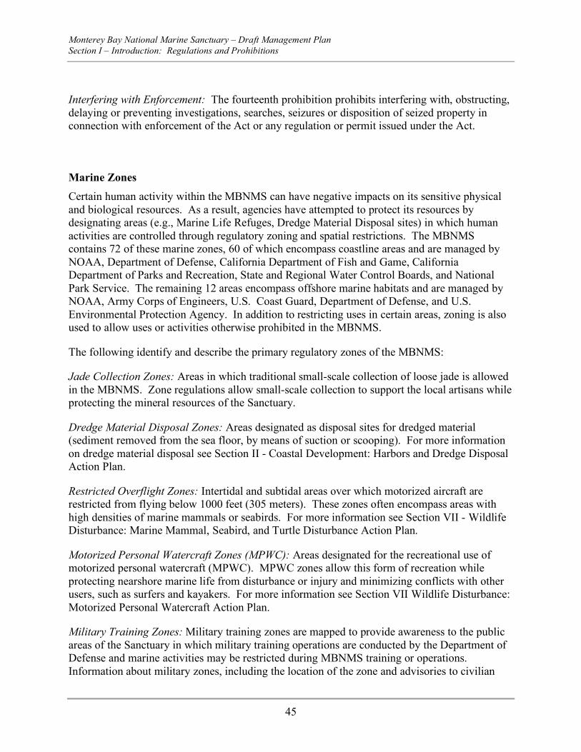
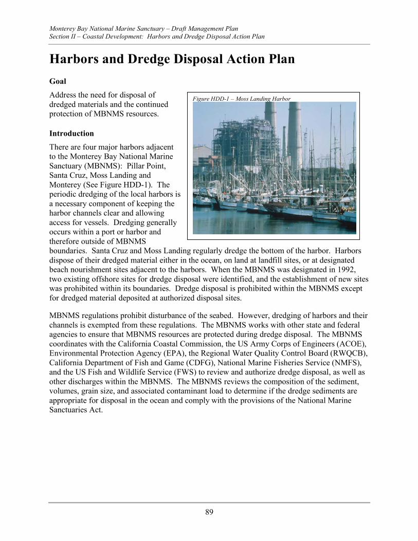
Background The Monterey Bay National Marine Sanctuary (MBNMS), designated in 1992, is a federally protected marine area offshore of California’s central coast. Stretching from Marin to Cambria, the MBNMS encompasses a shoreline length of 276 miles and 5,322 square miles of ocean, extending an average distance of twenty-five miles from shore. At its deepest point, the MBNMS reaches down 10,663 feet (more than two miles). The MBNMS encompasses a range of habitats from sandy beaches to rocky intertidal areas to open ocean, as well as the nation’s largest kelp forest and submarine canyon. Its highly productive biological communities host one of the highest levels of marine biodiversity in the world, including twenty-six threatened and endangered species. The MBNMS is adjacent to one of the largest urban concentrations in North America with several population centers of approximately 8 million people living within fifty miles of its shoreline, many who rely on MBNMS resources for pleasure or work.
This draft management plan is a revision of the original management plan adopted with MBNMS designation in 1992 and is focused on how to best understand and protect the resources of the MBNMS. By centering around issues, this draft management plan is structured differently from the original 1992 management plan, and provides guidance to the public and the National Marine Sanctuary Program as to how the MBNMS will address the priority resource management issues, challenges, and opportunities of the future. This plan was developed with extensive public input from twenty public scoping meetings, over 12,000 written comments, twenty Sanctuary Advisory Council meetings, and sixty-eight meetings of volunteer working groups, offering input and recommendations regarding which issues the MBNMS must address and how to address them. The invaluable time provided by members of the public and government agencies to offer advice and guidance to the MBNMS in public meetings alone totals well over 8,000 hours in the development of this plan.
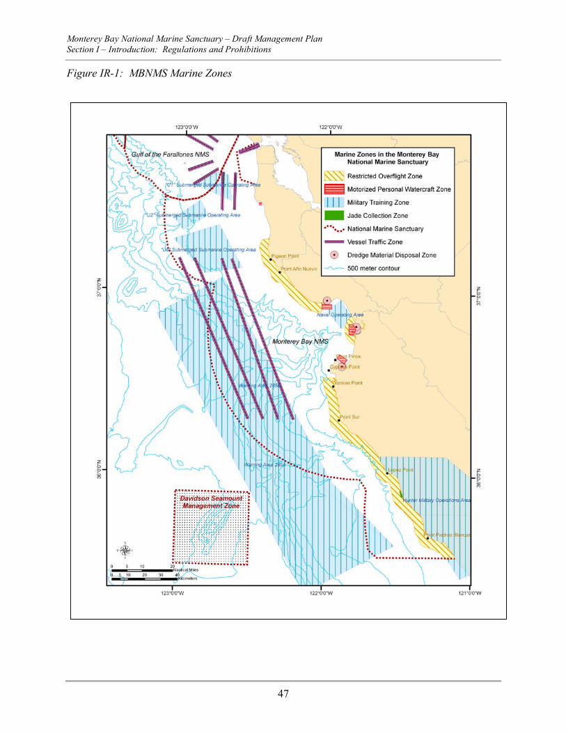
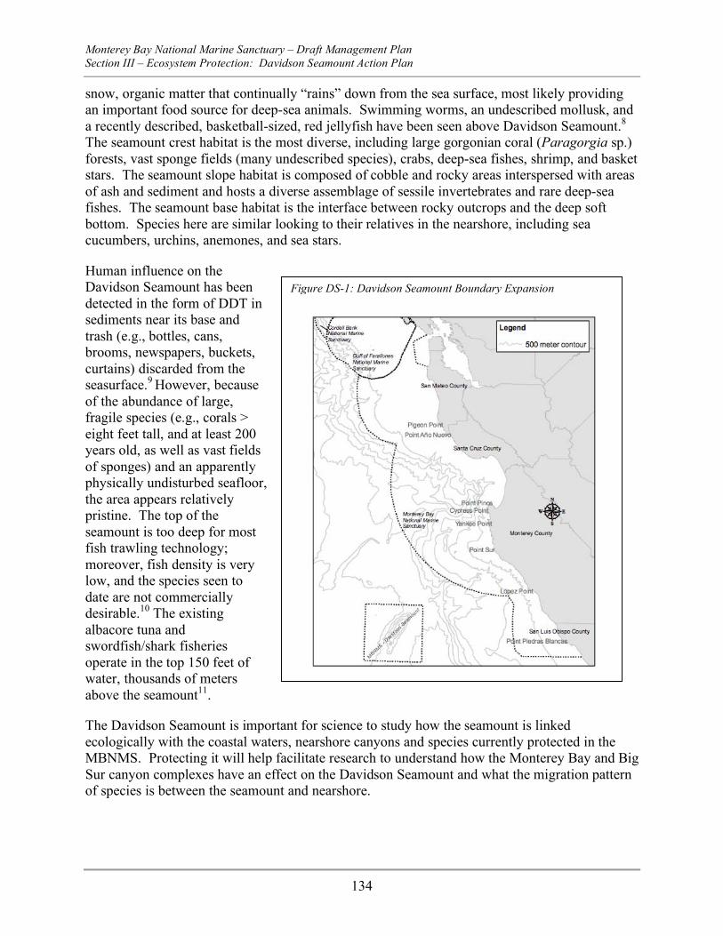
Figure 1.1 – MBNMS Boundary
Monterey Bay National Marine Sanctuary – Draft Management Plan Section I – Introduction: Background
14
There are many marine resource management issues confronting the MBNMS. The action plans that make up this management plan provide strategies to understand the issues, understand the coastal and marine environments which comprise the marine sanctuary, and address those issues through education and outreach, research and monitoring, collaborative planning and management efforts, and regulation and enforcement where necessary. All actions are addressed in partnership with the local, state and other federal agencies, as well as the many stakeholders that have an interest in the MBNMS.
This management plan is comprised of twenty-three action plans guideing the MBNMS for at least the next five years. The action plans are grouped into four main marine management themes: Coastal Development, Ecosystem Protection, Water Quality and Wildlife Disturbance. Each section contains several action plans that address issues that were determined to be a priority for the MBNMS to address through the public scoping process and prioritization by the Sanctuary Advisory Council (SAC). Two additional management themes, Partnerships and Opportunities, as well as Operations and Administration, are comprised of action plans and strategies addressing how the MBNMS will function and operate, and work with our partners in providing the services necessary to implement the mandates outlined in the National Marine Sanctuaries Act as well as address the priority marine management issues.
Each action plan details the management action and provides an estimated cost to fully implement the action plan. The action plans also contain mechanisms to evaluate the performance of the MBNMS in addressing the goals and a description of the products and services necessary to accomplish those goals.
This section provides background on the National Marine Sanctuary Program (NMSP), the MBNMS, and the management plan review process. It describes the organic act establishing the NMSP and the administrative hierarchy within which the program resides. Next, it details the history, mission, goals, and accomplishments of the MBNMS. Finally, this section introduces the fundamental steps of the management plan review process concluding with development of the new draft management plan.
Overview of the National Marine Sanctuary Program The NMSP resides within the Department of Commerce, managed by the National Ocean Service (NOS) in the National Oceanic and Atmospheric Administration (NOAA). The NMSP is comprised of a system of thirteen marine protected areas encompassing marine and freshwater resources from Washington State to the Florida Keys, from Massachusetts to American Samoa, and from Lake Huron to the Gulf of Mexico. Additionally, the NMSP is currently considering sanctuary designation for the Northwestern Hawaiian Islands Coral Reef Ecosystem Reserve.
The national marine sanctuaries system contains many unique and special marine features, including kelp forests, deep ocean gardens, near-shore coral reefs, areas for whale feeding, reproduction and migration, deep-sea canyons and underwater archaeological sites. Sanctuaries range in size from one-quarter square mile in American Samoa’s Fagatele Bay to the more than 5,300 square miles of the MBNMS, one of the largest marine protected areas in the world. Together, these sanctuaries protect nearly 18,000 square miles of coastal, open ocean and Great Lake waters and habitats.
Monterey Bay National Marine Sanctuary – Draft Management Plan Section I – Introduction: Background
15
The NMSP provides oversight and coordination among the thirteen sanctuaries by setting priorities for addressing resource management issues and directing program and policy development. The NMSP also has responsibility for ensuring that the management plan prepared for each sanctuary is consistent with the National Marine Sanctuaries Act (NMSA), addresses current threats and management strategies, and provides a general budget to estimate expenditures for program development, operating costs, and staffing.
On an annual basis, the NMSP reviews and adjusts funding priorities and requirements to reflect resource management needs at each of the thirteen sanctuaries. The NMSP also monitors the effectiveness of the management plan, makes recommendations to promulgate regulatory changes where necessary and monitors intra- and inter-agency agreements.
The National Marine Sanctuaries Act The National Marine Sanctuaries Act (NMSA) of 1972 (16 U.S.C. §1431 et seq.) is the legislative mandate that governs the NMSP. The NMSA authorizes the Secretary of Commerce to designate as national marine sanctuaries areas of the marine environment or Great Lakes with special national significance due to their conservation, recreational, ecological, historical, scientific, cultural, archeological, educational, or aesthetic qualities. Additionally, the NMSA established the NMSP as the federal program charged with managing national marine sanctuaries. The primary objective of the NMSA is to protect marine resources. The NMSA also directs the NMSP to facilitate all public and private uses of those resources compatible with the primary objective of resource protection.
The purposes and policies of the NMSA (15 C.F.R., Part 922.2(b)) are:
1. To identify and designate as national marine sanctuaries areas of the marine environment which are of special national significance and to manage these areas as the National Marine Sanctuaries Program;
2. To provide authority for comprehensive and coordinated conservation and management of these marine areas, and activities affecting them, in a manner that complements existing regulatory authorities;
3. To maintain the natural biological communities in the national marine sanctuaries, and to protect, and, where appropriate, restore and enhance natural habitats, populations, and ecological processes;
4. To enhance public awareness, understanding, appreciation, and wise and sustainable use of the marine environment, and the natural, historical, cultural, and archeological resources of the National Marine Sanctuaries Program;
5. To support, promote, and coordinate scientific research on, and long-term monitoring of, the resources of these marine areas;
6. To facilitate to the extent compatible with the primary objective of resource protection, all public and private uses of the resources of these marine areas not prohibited pursuant to other authorities;
7. To develop and implement coordinated plans for the protection and management of these areas with appropriate federal agencies, state and local governments, Native American tribes and
Monterey Bay National Marine Sanctuary – Draft Management Plan Section I – Introduction: Background
16
organizations, international organizations, and other public and private interests concerned with the continuing health and resilience of these marine areas;
8. To create models of, and incentives for, ways to conserve and manage these areas, including the application of innovative management techniques; and
9. To cooperate with global programs encouraging conservation of marine resources.
A complete version of the NMSA (as amended) is available from the NMSP website at www.sanctuaries.nos.noaa.gov.
Monterey Bay National Marine Sanctuary – Draft Management Plan Section I – Introduction: Background
17
Figure 1.2 – National Marine Sanctuary System
Ecosystem-Based Management in the NMSP The NMSA states that the NMSP shall “maintain for future generations the habitat and ecological services of the natural assemblage of living resources that inhabit [Sanctuaries]” (16 U.S.C. 1431 et seq., §301(a)(4)(A),(C)) and “while the need to control the effects of particular activities has led to enactment of resource-specific legislation, these laws cannot in all cases provide a coordinated and comprehensive approach to the conservation and management of the marine environment” (16 U.S.C. 1431 et seq., §301(a)(3)). As such, the thirteen national marine Sanctuaries subscribe to a broad and comprehensive management approach that is in keeping with the NMSA’s primary objective of resource protection. This approach differs from the various national and local agencies and laws directed at managing single or limited numbers of species or specific human activities within the ocean. Ecosystem-based management serves as a framework for addressing long-term protection of a wide range of living and non-living marine resources, while allowing multiple uses of the Sanctuary that are compatible with resource protection. These ecosystems managed by the NMSP span diverse geographic, administrative, political and economic boundaries, and the need for strong partnerships among resource agencies, non-governmental interests, members of the public and scientific community, user groups and conservationists is essential.
Monterey Bay National Marine Sanctuary – Draft Management Plan Section I – Introduction: Background
18
Monterey Bay National Marine Sanctuary
Designation The MBNMS was established for the purpose of resource protection, research, education and public use. Its natural resources include our nation’s largest contiguous kelp forests, one of North America’s largest underwater canyons and the closest-to-shore, deep ocean environment off the continental United States. It is home to one of the most diverse and productive marine ecosystems in the world, including a vast diversity of marine life, with 33 species of marine mammals (it’s one of the best places in the world to view elephant seals, sea otters, and a huge variety of whales and dolphins), 94 species of seabirds, 345 species of fish, four species of sea turtles, 31 phyla of invertebrates, and more than 450 species of marine algae. It is the “Serengeti of the Sea.” It is also home to 26 species that receive special protection under the Endangered Species Act. Federally-listed threatened or endangered species include six species of large whales, the Southern sea otter, Steller sea lion, Guadalupe fur seal, California Brown Pelican, California Clapper Rail, Western Snowy Plover, Marbled Murrelet, four species of sea turtles, six species of salmon or steelhead, and the tidewater goby. The MBNMS is also a meeting place for the geographic ranges of many species. It lies at the southern end of the range for some species, like the Steller sea lion, occurring from central California north to Alaska and Japan; and it lies at the northern end of the range for others, like giant kelp, occurring from San Francisco to Baja California, Mexico.
The MBNMS includes one of four major coastal upwelling regions worldwide. Coastal upwelling occurs along the western edges of continents, where winds moving from the poles to the equator drive oceanic surface waters away from shore due to the Coriolis effect. These shallow, warm waters are replaced by deep, cold and nutrient rich waters driving high primary productivity, allowing phytoplankton to bloom, which in turn support zooplankton, providing a key prey resource for higher-order predators such as fishes, birds, and whales. Globally, these upwelling regions rival the productivity of tropical rain forests, and account for nearly 95 percent of the annual global production of marine biomass, in spite of only representing 0.1 percent of the ocean’s total surface area.
There are a variety of potential resource threats and opportunities within the MBNMS due to the sensitivity of habitats and species in the region, the long stretch of adjacent populated coastline with several urban centers along the MBNMS’s shoreline, and the multiple uses of the marine environment. MBNMS research and monitoring programs evaluate the status and health of marine species, habitats and ecosystems, provide critical information to resource managers, and coordinate activities with the array of world-class research institutions in the region. Resource protection activities use a variety of means to reduce or prevent detrimental human impacts, including collaborative planning and management efforts, regulations and permits, emergency response activities, and enforcement. Education and outreach is used as a critical element in enhancing understanding and stewardship of this national treasure, utilizing tools ranging from public events and interactive teacher workshops to extensive written materials.
Cultural resources abound as well and are protected by MBNMS regulations. Archeologists estimate approximately 445 reported vessel (shipwrecks or aircraft) losses within the waters of the MBNMS, and 718 historic sites line its shores.
Monterey Bay National Marine Sanctuary – Draft Management Plan Section I – Introduction: Background
19
History As directed congressionally by the Oceans Act of 1992, the MBNMS was officially established in 1992 by authority of the Secretary of Commerce under the 1972 Marine Protection, Research, and Sanctuaries Act (Title III, as amended 16 U.S.C. §§1431 et seq.). This designation was achieved 15 years after it was first nominated by the State of California for consideration as a national marine sanctuary. During this period, many site analyses and meetings were conducted to determine whether this region met the designation criteria required by the NMSA, that is,
A. "the area is of special national significance due to its resource or human-use values, B. existing state and federal authorities are inadequate to ensure coordinated and
comprehensive conservation and management of the area, including resource protection, scientific research, and public education,
C. designation of the area will ensure comprehensive conservation and management, including resource protection, scientific research, and public education,
D. the area is of a size and nature that will permit comprehensive and coordinated conservation and management."
Under the 1988 reauthorization of the Marine Protection, Research, and Sanctuaries Act, NOAA was directed to designate Monterey Bay as a national marine sanctuary. On August 3, 1990, NOAA released the DEIS/MP for the proposed MBNMS and published proposed regulations. NOAA held public hearings and published the Final Management Plan and Environmental Impact Statement in June of 1992. The MBNMS Regulations and Final Rule were published in the Federal Register on September 18, 1992.
Goals and Accomplishments The MBNMS Program’s goals are to:
1. Enhance resource protection, through comprehensive and coordinated conservation and management tailored to the specific resources that complements existing regulatory authorities
2. Support, promote and coordinate scientific research on, and monitoring of, the site-specific marine resources to improve management decision-making
3. Enhance public awareness, understanding, and wise use of the marine environment through public interpretive and recreational programs
4. Facilitate, to the extent compatible with the primary objective of resource protection, multiple uses of these marine areas not prohibited pursuant to other authorities
Four program areas generally divide the administration of the MBNMS: research and monitoring, resource protection, education and outreach, and program operations. Following is a description of these areas and accomplishments since MBNMS designation.
Research and Monitoring The research and monitoring program’s focus is on science for resource management: determining information gaps; developing collaborative studies to improve understanding of
Monterey Bay National Marine Sanctuary – Draft Management Plan Section I – Introduction: Background
20
issues; and interpreting research for decision makers. Much of the credit for the research in the MBNMS belongs to the world-renowned and extremely collaborative research community in central California. For example, approximately twenty research institutions are represented on the MBNMS Research Activity Panel, which wrote the first-ever MBNMS Research Plan. Many members also contributed text and bibliography files to a web-based Site Characterization that summarizes existing information on the MBNMS’s natural resources. In turn, the MBNMS identified the need for research to address specific resource management issues and provided a method for applying scientific results to public policy. This resulted in several multi-million dollar efforts to map MBNMS habitats, monitor nearshore ecosystems, and model ocean circulation.
Through MBNMS funding, writing issue reviews, building collaborations, providing research platforms, and obtaining grants, the research and monitoring program achieved notable success in:
− Monitoring beach-cast seabirds and marine mammals, seabirds, marine mammals, and krill in Monterey Bay; gray whale migrations; kelp canopies; rocky shores; and water quality in Elkhorn Slough
− Characterizing pinniped rookeries; seafloor habitats in the nearshore, offshore, and in formerly restricted military zones; and even management issues such as marine zoning regulation and kelp harvesting
− Providing extensive information in technical reports available on the web; at symposia coordinated with the MBNMS Education Program and local governments; and through numerous technical advisory committees
− Studying tidal erosion in Elkhorn Slough; distribution of introduced species; sea lion deaths caused by harmful algal blooms; fishery impacts from trawling and gillnet by-catch; coastal erosion; impacts of ship groundings and oil spills; and human use effects in kelp forest and rocky shore systems
As public and resource management needs are clarified through MBNMS advisory groups and in coordination with the MBNMS resource protection program, it becomes evident more research and monitoring is needed than has been completed. Habitat mapping has improved since 1992, yet most of the habitats and distribution and abundance of key species have not been mapped or measured. Moreover, little data exists on how human activities are changing the MBNMS ecosystem through time. The MBNMS initiated its ecosystem monitoring program, the Sanctuary Integrated Monitoring Network (SIMoN), in 1999 with grant funding awarded in 2001. After hiring staff and developing the infrastructure, the website for SIMoN was launched in 2003 which provides the public, decision makers and the research community with monitoring data and an integrated view of data collecting efforts.
Resource Protection A key objective of the management plan is to ensure that human activities in the MBNMS do not adversely affect natural resources, including habitats. This is accomplished through a variety of approaches, including collaborative planning efforts to prevent and reduce human impacts, regulations, permits, and enforcement efforts. Management efforts also involve helping to
Monterey Bay National Marine Sanctuary – Draft Management Plan Section I – Introduction: Background
21
educate the public and MBNMS users about how they can minimize or eliminate harmful behavior. The resource protection program also administers the Conservation Working Group (CWG), which was originally formed to focus the knowledge and talent of local, regional, and national conservation groups on the designation process for the Monterey Bay National Marine Sanctuary. The CWG now works to serve as a forum for conservation issues, identify resource protection needs, and provide advice, views, and factual information on resource protection, Sanctuary management, and other issues in response to requests from staff, the SAC and associated working groups, and other appropriate parties.
The MBNMS’s long coastline, including four harbors and several urban areas, create multiple, complex threats to a healthy coastal ecosystem. A key goal is to actively prevent damage to the resources, thereby avoiding crisis situations apparent elsewhere in the country. The resource protection program accomplished many important objectives such as:
− A Water Quality Protection Program developed and partially implemented three plans to improve or protect water quality (related to urban runoff, harbors and marinas, and agriculture and rural lands) as well as plans to strengthen coordinated regional water quality monitoring by government agencies and citizen groups
− Strategies, now approved at the international level, to move large commercial ships farther offshore and use north-south transit lanes to reduce threats of spills from vessel traffic such as container ships, bulk product carriers, and tankers
− Participation in research and a long-range management plan for Highway 1 reducing impacts from landslide repair and disposal activities
− Establishment of an Interpretive Enforcement Program, including a NOAA Office of Law Enforcement officer assigned to focus exclusively on MBNMS enforcement issues
− Development of a cooperative enforcement agreement with state agencies − A hazardous material/emergency response program for events such as spills and
vessel groundings − Collaborative educational products and outreach on resource protection issues such as
water quality, motorized personal watercraft (MPWCs), boating, and vessel traffic − Development of a permit program to review planned activities that may harm
MBNMS resources and to issue permits or other authorizations with conditions to minimize impacts
− Coordinated review of projects, plans and permits of other agencies to minimize impacts
Education and Outreach The MBNMS’s education and outreach efforts help connect people to the marine environment. The Education program’s goal is to promote public understanding of our national marine Sanctuaries and empower citizens with the knowledge necessary to make informed decisions leading to the responsible stewardship of aquatic ecosystems. Partnerships and collaboration have played a key role in the development and implementation of the MBNMS’s educational efforts. The MBNMS Education Panel, comprised of marine educators representing twenty
Monterey Bay National Marine Sanctuary – Draft Management Plan Section I – Introduction: Background
22
organizations and schools, is a prime example of how the MBNMS works with the regional community to shape the MBNMS’s educational focus. The Education and Outreach Program has accomplished or has underway some important objectives of the management plan, such as:
Increasing public awareness of our Sanctuaries through a variety of techniques, including:
− Public lectures and forums and the annual MBNMS Currents Symposium − Anniversary celebrations and a variety of public events − Interpretive signs and displays at state parks, beaches, and interpretive facilities − Educational products and materials including books, brochures, posters, maps,
newsletters, annual reports, videos, and an extensive web site − Operation of MBNMS’s Team Ocean Conservation Education Action Network
(OCEAN) and support of volunteer programs, including Bay Net, Save Our Shores, and Friends of the Elephant Seal
− Providing education to address specific issues that may threaten MBNMS resources by:
− Developing a variety of water quality programs and products to address urban runoff − Providing public outreach to promote stewardship of endangered species, fragile
habitats like tidepools, and protected species such as marine mammals − Developing and distributing educational materials on shipping lanes to mariners − Providing educational opportunities for teachers and students by: − Developing school curricula − Organizing teacher workshops − Providing shipboard and submersible “teacher-in-the-sea” opportunities − Coordinating teacher-led intertidal monitoring programs for high school students − Supporting the development of Camp SEA (Science, Education, and Adventure) Lab,
a residential marine science program
Program Operations Critical to the MBNMS’s successful operation is an effective program to support the research, resource protection, education, and outreach efforts.
Important parts of the program operations function already in place include:
− Computer system and associated network − A geographic information system (GIS) − Shared NOAA aircraft (with Channel Islands National Marine Sanctuary) − One small patrol boat for enforcement, research, monitoring, and buoy maintenance − A diving program for enforcement, research and monitoring − Support and operation of the Sanctuary Advisory Council − Support and operation of the Business and Tourism Activities Panel (BTAP)
Monterey Bay National Marine Sanctuary – Draft Management Plan Section I – Introduction: Background
23
− Non-profit foundation to support MBNMS activities and projects − One main office and two smaller field offices
Public Participation and the Sanctuary Advisory Council The citizens of central California are very politically and socially engaged on issues affecting their communities and the surrounding environment, including the ocean. The MBNMS owes its existence largely to the dedication and determination of thousands of local citizens and elected officials who strongly advocated for its designation. To this day, public participation permeates nearly every aspect of Sanctuary management and operation, from participating in the MBNMS Advisory Council and its working groups, to volunteering for one of many organizations helping the MBNMS achieve its education and research missions, to participating in community festivals and symposia.
Establishing the Sanctuary Advisory Council (SAC) for the purpose of advising the superintendent on policy issues affecting the MBNMS was identified in the MBNMS’s 1992 Management Plan and one of the MBNMS’ first accomplishments. As local involvement in the MBNMS was a vision by the community in 1992, the Management Plan directed the MBNMS to consult with all interested groups and agencies to ensure that the Advisory Council was representative of a broad-based constituency. The SAC is comprised of twenty voting members and six non-voting members representing various stakeholders. Since its establishment in March 1994, the group has played a vital role in many decisions affecting the central California coast. The SAC also has four standing working groups:
− Conservation Working Group: coordinates the efforts of existing organizations and helps promote and achieve comprehensive and long-lasting stewardship of the MBNMS through continued oversight and advocacy.
− Research Activity Panel: promotes a comprehensive understanding of existing research activities and institutions, reviews research proposals, advises on research priorities, provides scientific advice and objective information, and assists in the implementation of programs to increase our scientific understanding of the MBNMS.
− Sanctuary Education Panel: promotes a comprehensive understanding of existing education activities and organizations, reviews program proposals, advises on educational priorities, and assists in implementation of programs to increase understanding and stewardship of the MBNMS.
− Business and Tourism Activity Panel: strengthens economic partnerships with the MBNMS and provides a forum for local businesses to discuss MBNMS-related issues.
Monterey Bay National Marine Sanctuary – Draft Management Plan Section I – Introduction: Monterey Bay National Marine Sanctuary Setting
25
Monterey Bay National Marine Sanctuary Setting Human Environment
Regional Context Five counties border the Monterey Bay National Marine Sanctuary (MBNMS): Marin, San Mateo, Santa Cruz, Monterey and San Luis Obispo. Two additional inland counties, Santa Clara and San Benito drain directly into the MBNMS. Each is diverse in terms of population and economic base. The northern region borders Marin County and the San Francisco Peninsula. This includes San Mateo County and Santa Clara County, an inland county home to the San Jose metropolitan area commonly known as Silicon Valley due to the large concentration of high technology businesses. Growth along the coast has been somewhat constrained by limited water availability, few access roadways, and strong environmental advocacy. However, due to the rapid growth of the technology sector, the Silicon Valley area exerts significant development pressure to the south and westward toward the coast. In the southern region, Monterey County faces significant growth challenges. Agriculture is the leading industry, followed by tourism. San Luis Obispo County’s economy focuses on agriculture, tourism, and education. These counties face significant economic and developmental challenges in addressing population growth. Limited infrastructure to accommodate the coastal population growth, a lack of labor for growing companies, a growing gap between the wealthy and other residents, and environmental pressures comprise the main constraints to urban expansion.
Figure S-1: MBNMS Boundary and Coastal Counties
Monterey Bay National Marine Sanctuary – Draft Management Plan Section I – Introduction: Monterey Bay National Marine Sanctuary Setting
26
Socio-Economic Environment There is a rich history of human use of central California’s marine resources, beginning with the Native Americans and continuing to the present. Today the MBNMS’s spectacular scenery, moderate climate, abundance of marine life, and relatively clean ocean waters all draw large numbers of divers, kayakers, boaters, fishermen, surfers, tidepoolers, and bird and mammal watchers. Coastal tourism, agriculture, and commercial fisheries are all pillars of the regional economy with direct links to the MBNMS.
Travel and tourism is one of the most significant industries, with total travel-spending revenue in 2003 of $5.9 billion for the five counties adjacent to the MBNMS. San Mateo leads in total spending at $2.0 billion, followed by Monterey at $1.8 billion, and San Luis Obispo at $ 930 million. (Source: Dean Runyan and Associates) Two of the main reasons given for travel to the coastal region are its natural and scenic beauty and recreational opportunities. Agriculture is also an important industry in the MBNMS region and the area is a national leader in the production of artichokes, strawberries, and salad greens. It was valued at $3.65 billion for the region (including the inland counties of Santa Clara and San Benito) in 1999. Monterey County, valued at $2.44 billion, is by far the most significant producer in the region and ranks third highest statewide. Other MBNMS-related industries include aquaculture, kelp harvesting, sand mining, and commercial shipping. The adjacent San Francisco Harbor is the largest harbor on the U.S. Pacific Coast with over 60,000,000 tons of cargo passing through the Golden Gate.
The fishing industry constitutes a relatively small portion of the overall economy, both regionally and statewide. However, it reflects an important component to the historical, economic, and cultural fabric of the region. Most fish caught within the MBNMS are landed at one of five main ports: Princeton /Half Moon Bay, Santa Cruz, Moss Landing, Monterey Bay, or Morro Bay. More than 600 commercial vessels fish within the MBNMS annually, and more than 80 percent of the commercial landings are comprised of squid, rockfishes, Dover sole, anchovy, mackerel, sardines, sablefish, albacore, and salmon. In 2003, ex-vessel revenues for all species within the MBNMS totaled almost $16.6 million dollars paid to commercial fishers in California. Additional revenue is also generated from the businesses associated with fishing operations, including marinas, maintenance operations, and equipment.
The rich biodiversity and close proximity of the deep sea also provide unparalleled research opportunities for approximately twenty-five marine science facilities that, in 2004, employed almost 2,000 people in staff and researchers with a combined budget of over $200,000,000. This includes government agencies, public and private university research institutions, and private facilities such as the Monterey Bay Aquarium and the Monterey Bay Aquarium Research Institute.
Human History and Resource Use Humans settled in the vicinity of MBNMS at least 10,000 years ago. At the time of Spanish arrival in the early 1700’s, about forty Native American tribes populated coastal areas from San Francisco Bay to Point Sur, consuming acorns, terrestrial plants and animals, intertidal invertebrates, fish, and marine mammals. The Spanish called the Indians "Costanoans,” meaning "coast dwellers." Today they are known as the Ohlone, meaning "people of the west.” Shell midden piles left by the Costanoans have been found at most substantial drainages and shorelines
Monterey Bay National Marine Sanctuary – Draft Management Plan Section I – Introduction: Monterey Bay National Marine Sanctuary Setting
27
between Morro Bay and Monterey Bay, comprised primarily of remains of abalone, California mussels, clams, snails, chitons, limpets, and other invertebrate groups. The quantity of shells suggests that Costanoan Indians were "a principal control of animal population sizes" in the intertidal zone in some areas. Costanoans also used fire to manage terrestrial vegetation for purposes such as enhancing growth and preparing plants for harvest.
Spanish settlements arose in the late 1700’s, and they began to exploit both natural resources and the Ohlone. They established a pastoral lifestyle and an extensive network of missions that relied heavily on livestock. Sweeping changes in the resulting landscape included greatly enlarged pasturelands throughout fertile drainages of the MBNMS and incidental importation of many exotic grasses and other plants. The Spanish also hired imported Russian or local Indian hunters to hunt sea otters. These valuable pelts were exported to Asia, Europe, and the Americas. Sea otters became scarce around Monterey Bay by the late 1800’s. The Spanish harvested abalone for trade with northwest coast Indians. Indian populations plummeted after establishment of the Missions due to introduced diseases, cultural dissolution, and exploitation by the Spanish and later the Mexicans. Many European traders and explorers of the late 1700’s wrote of the remarkable abundance and richness of wildlife in the Monterey Bay area. French explorer Jean Francoise de La Perouse, the first foreign visitor to the Spanish outposts, wrote his ships were "surrounded by pelicans and spouting whales. There is not a country in this world which more abounds in fish and game of every description."
New England whalers often hunted along the central coast in the late 1700’s and early 1800’s, feeding a voracious east coast market for oil, baleen and meat. Portuguese whalers from the Azores, originally brought to Monterey Bay as crew on the deep-water ships, settled in Monterey Bay by the 1850’s. The Portuguese worked in shore-whaling operations begun by Yankee whaler John Davenport, which targeted humpbacks and gray whales (though other species were also captured). As the price of whale oil decreased due to the production of kerosene in the 1880’s, shore whaling died out. A brief resurgence in whaling occurred along the California coast in the 1900’s, including a short-lived Norwegian-style and -owned modern whaling operation between 1919-1926 in Moss Landing.
In the 1850’s, ethnic Chinese settled in Monterey to harvest kelp and to fish for abalone, squid and shark. These products were dried and shipped to San Francisco and China. This industry helped feed California’s burgeoning Gold Rush population. By 1900, abalone were so scarce the commercial harvest was banned, and the Chinese turned to other fisheries, especially as market demand from San Francisco increased. The construction of the San Francisco/Monterey railway in the 1860’s allowed for rapid transport of fresh fish. Genovese Italian immigrants established fishing settlements around Monterey Bay in the 1870’s, providing a variety of fresh fish to the San Francisco markets via railroad. Sicilian fishermen followed in 1906, and soon focused on the sardine fishery. The sardine fishery peaked from 1910-1930, collapsed in the 1930’s, and has not yet recovered to its former size. Several other ethnic groups harvested MBNMS natural resources during this century, including Japanese hard-hat abalone divers (1900-1941), Vietnamese gillnet fishermen (1979-present), and offshore foreign (Russian, Polish and others) fishing fleets. All adapted to become part of the multicultural population that continues to utilize the resources of this biologically rich region. (Adapted from MBNMS Site Characterization, 1996.)
Monterey Bay National Marine Sanctuary – Draft Management Plan Section I – Introduction: Monterey Bay National Marine Sanctuary Setting
28
Physical Environment and Natural Habitats
Regional Geography The MBNMS contains one of the world’s most geologically diverse and complex seafloors and continental margins. The MBNMS is located on a plate boundary that separates the North American Plate from the Pacific Plate, and is marked by the San Andreas Fault system. This is an active tectonic region with common occurrences of earthquakes, submarine landslides, turbidity currents, flood discharges and coastal erosion. It is also a region of extensive natural and economic resources.
Coastal topography varies greatly, encompassing steep bluffs with flat-topped terraces and pocket beaches to the north; large sandy beaches bordered by cliff and large dune fields mid-MBNMS; and predominately steep, rocky cliffs to the south. Low- to high-relief mountain ranges and broad, flat-floored valleys are prevalent farther inland.
The Santa Cruz and Gabilan mountain ranges dominate the topography in the northern and central half of the region. Two major rivers (San Lorenzo and Pajaro Rivers) and a major creek (Scott Creek) enter Monterey Bay from these highlands through well defined valleys. Elkhorn Slough, an old river estuary occupied today only by tidal salt marshes, extends inland from Moss Landing for more than six miles. The broad, extensive Salinas Valley, the Gabilan Range, and the northern Santa Lucia Range are the dominant topographic features in the southern half of the region; the Salinas River is the major drainage system. South of Monterey, the west flank of the Santa Lucia Range drops abruptly into the ocean. Here, the valleys of the Carmel and Little Sur Rivers are dominant topographic features. From Point Sur to Morro Bay, many streams and creeks drain the southern Santa Lucias and cut the steep western face of the mountain range.
The watersheds of much of Northern and Central California, including the Central Valley, drain into the San Francisco Bay and Sacramento-San Joaquin Delta, which contain most of the state’s remaining coastal wetlands. More than a third of the state’s land mass drains from the Central Valley, Sierra Nevadas, and Cascade range into the bay which is the largest estuary on the west coast of North America.
Geology The MBNMS is within the active North American-Pacific plate boundary along the western margin of the San Andreas Fault system. The San Gregorio-Palo Colorado and Monterey Bay fault zones are the main southeast-northwest trending fault zones in the MBNMS. The San Gregorio-Palo Colorado fault zone is mapped as largely an offshore fault crossing nearly the entire MBNMS from offshore Partington Point in the Big Sur coast to north of Montara Point near Half Moon Bay, California. This fault zone is considered active with a 10 percent probability of an earthquake of magnitude 6.7 or greater by 2032. The formation and linear shape of the Carmel submarine Canyon is attributed to this fault zone. The Monterey Bay fault zone lies primarily offshore between the cities of Monterey and Santa Cruz and is approximately six to nine miles wide. It consists of a number of relatively short fault segments potentially affecting local submarine physiography.
Monterey Bay National Marine Sanctuary – Draft Management Plan Section I – Introduction: Monterey Bay National Marine Sanctuary Setting
29
Continental shelf (less than 400 feet water depth) sediments of the northern portion of the MBNMS vary from sand-dominated near shore and at the shelf edge to mud and silt-dominated in mid-shelf areas. The thickest accumulations of modern sediments are in mid-shelf regions. These sediment accumulation patterns determine biological habitats. In dynamic areas with high sediment deposition, organisms that are adapted to shifting substrate are found. Organisms that depend on shelter and steady algal growth are found on rocky substrate that does not experience major changes regularly. Bluff erosion, dune erosion, and sediment input from rivers and streams are the most significant sediment sources to the continental shelf in the MBNMS. The greatest concentrations of coarse-sand deposits have been found on the southern Monterey Bay shelf and on the shelf off the Big Sur coast. Submarine canyons, common to the MBNMS, are thought to contribute sediment to the deep sea. Erosion is greatest in winter months, especially during El Niño years. Beaches tend to rebuild whereas sand dunes and cliffs continuously retreat. The organisms that inhabit beaches are adapted for life in a continually changing environment, while sand dune communities transform as the dunes and cliffs retreat from the water’s edge. The highest erosion rates are found on dunes in southern Monterey Bay.
Oceanography Oceanographic processes in the MBNMS are influenced largely by the California Current. The California Current is an eastern boundary current that has been generally characterized as a broad, shallow, slow southward moving current, exhibiting high spatial and temporal variability. The California Current is the eastward portion of the clockwise North Pacific Gyre and transports cool water with low salinity towards the equator. Associated with the coastal surface flow is an undercurrent moving in the direction of the North Pole, the California Undercurrent, also referred to as the Davidson Current.
The California Current has many semi-stationary jets and eddies. Satellite imagery has shown cold filaments approximately thirty miles wide, extending approximately 150 miles offshore. The importance of these features, which represent the highly variable oceanographic weather of the California Current, lies in their offshore transport of cool, nutrient-rich water from depths to the surface, referred to as upwelling. The surface and intermediate depth water masses in the MBNMS are a mixture of Pacific Subarctic water having low salinity and cool temperatures and the warmer, saltier Pacific Equatorial water. The proportion of the types of water changes as does the strength of the northward flowing Davidson Current. Nearshore surface temperatures vary from 46°F during winter and early spring to 62°F during fall. Nearshore surface salinities vary from 34.0 psu (practical salinity units) when upwelling is strong to 33.2 psu otherwise. Streams and rivers can have large local effects on salinity.
There are three oceanic seasons in the Monterey Bay area during which upwelling, wind relaxation, and winter storm conditions prevail: the "upwelling period" from early spring to late summer when cool surface waters are found in the MBNMS; the "oceanic period" from late summer to early fall; and the "Davidson Current period" from late fall to late winter. Those descriptions may be useful to describe the changing hydrographic conditions along the MBNMS, but in reality these periods overlap extensively and do not recur with clockwork punctuality. The timing reflects changes in local winds and external effects such as El Niño and other long-term weather shifts. Within the coastal regime, sea surface flow undergoes a seasonal reversal. During the late fall and winter the direction is primarily poleward while equatorward flow
Monterey Bay National Marine Sanctuary – Draft Management Plan Section I – Introduction: Monterey Bay National Marine Sanctuary Setting
30
dominates during the spring and summer. The equatorward flow is coupled with the intensification of northwesterly winds that generally parallel the central California coastline. The sudden strengthening of the northwesterly winds, usually in March-May, may result in the "spring transition" in which upwelling commences and local sea surface temperatures fall by as much as 41°F within a few days. During late fall, the North Pacific High weakens and migrates southward and the thermal low disappears. The surface flow reverses to poleward.
When winds are strong from the northwest, water from the surface to about 165 feet has an offshore component. The sea surface is lowest along the coast and tilts upward by about eight inches across the width of the California Current (620 miles). Surface waters that moved seaward, are replaced by deeper upwelled waters that flow shoreward and upward. Although the seasonal changes in the MBNMS are important, longer-term inter-annual variations, principally "El Niño" events, also affect local physical and biological systems. El Niño is a warming of nearshore waters of the Eastern Pacific, caused by relaxation of the trade winds in the equatorial Pacific. Cessation or weakening of the trade winds allows the sea surface, which usually tilts upward by about one mile from east to west, to relax. This is accomplished as an eastward propagating pulse or Kelvin wave that takes several months to transit the equatorial Pacific. The wave propagates poleward along the coast of Central and North America and eventually is observed locally as warmer surface waters and higher than normal sea level. Local temperature anomalies up to 41°F and sea level anomalies of up to eight inches occur more or less periodically at intervals of three to five years.
Tides, the periodic rise and fall of the seas, are caused by the earth rotation, and the gravitational pull of the moon, the sun, and other celestial bodies. The MBNMS tides follow a mixed semidiurnal tidal pattern with two high-water and low-water phases per day. The tides are mixed because consecutive highs and lows have different tidal height. The internal tide in the Monterey Submarine Canyon is one of the remarkable oceanographic effects caused by the presence of the canyon cutting across the middle of Monterey Bay. Large internal underwater waves measuring up to 393 feet were recorded within three miles of the Monterey Canyon head. Energy lost upon breaking at the head of the Canyon leads to tidal rectification and promotes a net up-canyon flow, whose effects are similar to wind-driven upwelling. Internal waves may contribute up to 30 percent of the nutrients assimilated by phytoplankton during periods when upwelling is absent, and perhaps 10 percent of the required nutrients during periods of upwelling. The Canyon acts as a deep water conduit bringing offshore waters and organisms directly into the Bay and at the same time acts as a sediment drain.
Monterey Bay National Marine Sanctuary – Draft Management Plan Section I – Introduction: Monterey Bay National Marine Sanctuary Setting
31
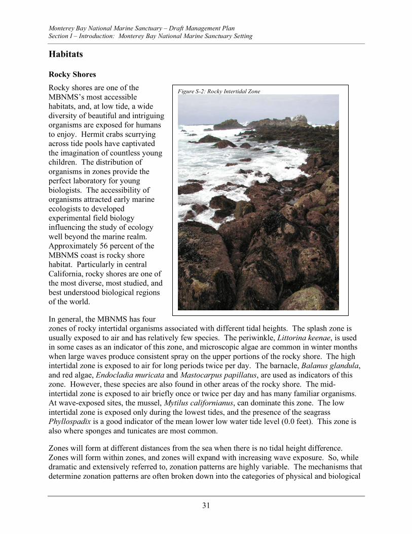
Habitats
Rocky Shores Rocky shores are one of the MBNMS’s most accessible habitats, and, at low tide, a wide diversity of beautiful and intriguing organisms are exposed for humans to enjoy. Hermit crabs scurrying across tide pools have captivated the imagination of countless young children. The distribution of organisms in zones provide the perfect laboratory for young biologists. The accessibility of organisms attracted early marine ecologists to developed experimental field biology influencing the study of ecology well beyond the marine realm. Approximately 56 percent of the MBNMS coast is rocky shore habitat. Particularly in central California, rocky shores are one of the most diverse, most studied, and best understood biological regions of the world.
In general, the MBNMS has four zones of rocky intertidal organisms associated with different tidal heights. The splash zone is usually exposed to air and has relatively few species. The periwinkle, Littorina keenae, is used in some cases as an indicator of this zone, and microscopic algae are common in winter months when large waves produce consistent spray on the upper portions of the rocky shore. The high intertidal zone is exposed to air for long periods twice per day. The barnacle, Balanus glandula, and red algae, Endocladia muricata and Mastocarpus papillatus, are used as indicators of this zone. However, these species are also found in other areas of the rocky shore. The mid-intertidal zone is exposed to air briefly once or twice per day and has many familiar organisms. At wave-exposed sites, the mussel, Mytilus californianus, can dominate this zone. The low intertidal zone is exposed only during the lowest tides, and the presence of the seagrass Phyllospadix is a good indicator of the mean lower low water tide level (0.0 feet). This zone is also where sponges and tunicates are most common.
Zones will form at different distances from the sea when there is no tidal height difference. Zones will form within zones, and zones will expand with increasing wave exposure. So, while dramatic and extensively referred to, zonation patterns are highly variable. The mechanisms that determine zonation patterns are often broken down into the categories of physical and biological
Figure S-2: Rocky Intertidal Zone
Monterey Bay National Marine Sanctuary – Draft Management Plan Section I – Introduction: Monterey Bay National Marine Sanctuary Setting
32
factors, and it is a combination of these that determines each site’s biological characteristics. Within zones, patchily distributed organisms are common. Indeed, rocky shores are sometimes referred to as mosaics of patches undergoing succession after a variety of possible disturbance events and times. Disturbances that open up space for colonization are caused by waves, predation by sea otters eating mussels, wave-tossed rocks and logs, substratum weathering and exfoliation, and human collection and trampling. Disturbances are common enough that some species persist as fugitives, dispersing from one patch to another, as the dominant competitors crowd them out.
Kelp Forests Kelp provides a unique and diverse habitat utilized by numerous species, including marine mammals, fishes, other algae, and vast numbers of invertebrates. Hugging the rocky coastline just beyond breaking waves, several species of kelp cling to hard substrates with their tenacious holdfasts and lend added vertical structure to the rocky reef habitat. Although some individual kelps can persist for up to three years, the overall structure of the kelp forest is very dynamic. Kelp canopy cover varies seasonally. It is thickest in late summer and thins or disappears in winter when large swells and old age combine to remove weakened adults. During the following spring, the next generation takes advantage of the thin canopy cover and increase in available light to grow rapidly. When coupled with upwelling, which brings cold, nutrient-rich waters to the surface, these conditions allow some species of kelp to grow up to twelve inches per day. The measured productivity (per square foot of sea floor) of a kelp forest is among the highest of any natural community in the world; only an Iowa cornfield is more productive.
Like terrestrial forests, kelp forests consist of layers. In central California, the two primary canopy-forming species in kelp forests are giant kelp, Macrocystis pyrifera, and bull kelp, Nereocystis luetkeana. Both of these seaweeds are brown algae (Phaeophyta). While both can be found within the same kelp forest, giant kelp is more typical of the Monterey Bay area and bull kelp is more common north of Santa Cruz and along the Big Sur coastline. The understory is the layer three to six feet above the bottom and is dominated by stalked brown algae such as Pterygophora californica and Laminaria setchellii. The lowest layer, turf algae, consists of several red algae, including corallines. These layers support a rich assemblage of fishes and invertebrates.
Figure S-2: Giant Kelp Forest
Monterey Bay National Marine Sanctuary – Draft Management Plan Section I – Introduction: Monterey Bay National Marine Sanctuary Setting
33
Some vertebrates, such as sea otters and many fishes, reside within kelp forests. Other vertebrates, such as seabirds, harbor seals, sea lions, and even gray whales will visit kelp forests while foraging for food. Giant kelp and other algae support large populations of benthic invertebrates, which in turn attract higher-order predators. SCUBA divers are also attracted to kelp forests and their rich invertebrate fauna, making dive sites in Monterey Bay and along the Big Sur coast among the most scenic in the world. And while kelp forests are used by dozens of seabirds and marine mammals, and hundreds of fishes and algae, it is the thousands of invertebrate species that make this system so rich and diverse.
Kelp forests and their associated flora and fauna are also important resources to humans. The complex canopies serve as nurseries for juvenile rockfishes, providing refuge during vulnerable stages of the life cycle. As these rockfish grow, some leave the kelp forest for deeper waters and support commercial and recreational fisheries. Kelp forests and their associated marine life are also an important part of the aesthetic experience that attracts visitors to Monterey Bay from all over the world. In addition, kelp is itself a resource, harvested as food for abalone farms and as a source of algin, an emulsifying and binding agent used in ice cream, toothpaste, and cosmetics.
Sandy Bottoms Most of the ocean floor in the MBNMS is covered with sand or mud. Waves and currents create sand waves and ripples, and organize sediment particles in different group sizes. The lack of hard substrate and the shifting sand prevents algae from settling, and therefore these vast sandy plains stretching in all directions appear to be lifeless deserts. However, many organisms live in the sand. There are two broad zones, including a shallow region dominated by crustaceans and a deeper area dominated by more sedentary polychaete worms. The crustacean zone continues up into the surf zone and intertidal beach zone, areas where sediment is constantly moving around. The main crustacean groups include those that burrow into the sand and those that are active on the surface of the sandy floor. All burrow into the seafloor and flourish in wave disturbed sandy bottoms. Here only few animals live in relatively permanent burrows or tubes. Most live close to the seafloor surface and do not burrow deeply. Benthic fishes are also less abundant in the crustacean zone than farther offshore.
Estuaries An estuary is a coastal body of water that connects a watershed to the open ocean. The resulting mix of land, fresh and salt water creates a mosaic of habitats and communities, changing from terrestrial to marine over small distances. By their very nature, estuaries are highly variable, affected by both marine and terrestrial processes. Environmental variables influencing the communities found within an estuary include tides, salinity, temperature, currents, sediment type, and dissolved oxygen. Unlike purely marine or freshwater habitats, which have relatively stable salinities and temperature ranges, an estuary is subject to dramatic changes in both temperature and salinity. The dramatic changes in temperature and salinity can stress the flora and fauna that make the estuary their home. As the tide flows in, fresh and salt water mix to form a gradient, which can move up and down the estuary over the course of a day. Some animals burrow into the soft sediments to seek refuge from these fluxes. Other animals thrive, having broad physiological tolerances that evolved in response to these stressors. Some environmental variables change spatially as well as over time, and influence the distribution of animals.
Monterey Bay National Marine Sanctuary – Draft Management Plan Section I – Introduction: Monterey Bay National Marine Sanctuary Setting
34
At the head of an estuary, where fresh water enters the system, salinity is very low, tidal influence is minimal, and the currents are dominated by watershed input and flow down stream. In the upper reaches of an estuary there is more of a marine influence, which leads to higher salinities and deposition of fine marine sediments. Topography of the area, as well as the extent and pattern of channels, determine the degree of the marine influence. In the middle reaches, sand may be present and mixed in with the fine mud, and water is generally brackish (salinity 18-25 parts per thousand). At the lower reaches, the marine influence dominates the system, with more sand, high flow patterns dominated by the tides, and salinities near marine levels. At the mouth of an estuary, there is usually little mud on the bottom, but fine sediments suspended in the water column can make turbid plumes that are clearly visible from the surface and extend out into the open ocean.
Beyond the communities of invertebrates and fishes that spend most or all of their time underwater, terrestrial communities add to the tremendous diversity of an estuary. Estuary habitats and communities include mudflats, eelgrass beds, salt marshes, beaches, coastal dunes, coastal maritime chaparral, and oak woodlands. Many birds use estuaries as important rest or feeding stops while migrating along the Pacific flyway. Partially within the MBNMS, Elkhorn Slough serves an important role in sustaining both resident and migratory birds, which utilize the resources generated by this highly productive ecosystem. Elkhorn Slough, designated in 2000 as a Globally Important Bird Area by the American Bird Conservancy, is a must-see site for avid bird watchers and visitors to Monterey Bay. In addition, the Elkhorn Slough National Estuarine Research Reserve is one of twenty-six National Estuarine Research Reserves established nationwide as field laboratories for scientific research and estuarine education. The Reserve is administered by the National Oceanic and Atmospheric Administration and managed by the California Department of Fish and Game and is the only National Estuarine Research Reserve contiguous with a National Marine Sanctuary.
Submarine Canyons Submarine canyons are prominent geomorphic features within the MBNMS. The Monterey Canyon is the largest of these submarine features and is similar in size to the Grand Canyon in Arizona. Submarine canyons share physical characteristics with onshore river valleys. Submarine canyons are erosional features carving into the seafloor and exposing older, underlying strata in canyon walls. Submarine canyons can have sinuous channel axes and may also have a number of branching channels. The positions of some channels coincide with geologic faults, like Carmel Canyon.
The deepest and largest submarine canyon on the coast of North America is the Monterey Canyon in the center of Monterey Bay. It is 292 miles long, approximately 7 miles wide at its widest point, and has a maximum rim to floor relief of 5577 feet. Numerous smaller canyons also exist in the MBNMS and incise the continental shelf and slope. Canyons terminating at the shoreline are thought to be active and are the major sediment transport conduits to the deep sea. The heads of Monterey Canyon, Carmel Canyon, and Partington Canyon reach the modern-day shoreline whereas most of the other canyons within the MBNMS terminate near the continental shelf edge. Much of the sediment carried by longshore currents ends up in the axes of active submarine canyons. Approximately 14,125,000 cubic feet of sand as well as large volumes of finer grained material descend into Monterey Canyon each year. The organic material associated
Monterey Bay National Marine Sanctuary – Draft Management Plan Section I – Introduction: Monterey Bay National Marine Sanctuary Setting
35
with these sediments provides nutrients to deep-sea organisms. Submarine landslides from canyon walls are also deposited in the canyons. Sand, gravel, mud, and skeletal remains of marine mammals have been observed in the axis of Monterey Canyon.
Submarine canyon sediment transport events are thought to be episodic. Potential triggering events include storms, earthquakes, moderate sea and surf conditions, tidal fluctuation, and flooding rivers. The frequency of these events is not well known. Repeat bathymetric mapping using high-resolution tools and installation of instruments in the canyons enable scientists to determine locations where deposition and erosion take place and to quantify the frequency and intensity of sediment transport events. Submarine canyons in MBNMS are also ecologically important to many species of fish. Canyons provide habitat for larger sized rockfish that seem to prefer structures of high relief such as boulders, vertical walls, and ridges. The cover and protection offered by submarine canyons allow pockets of rockfish populations to flourish, in contrast to more exposed areas where the populations are more easily fished. Monitoring programs in the sanctuary study the habitat use of rockfish in submarine canyons. These programs typically used manned and remotely operated submersibles to map the substrate type and quantify the amount of rock habitat available to fish.
Deep Sea The deep sea is a dark and cold environment which includes a variety of habitats from the midwater to the abyss that are populated by a wide array of animals, specially adapted to live under the tremendous water pressure and low level of oxygen of this harsh environment. The mesopelagic zone starts at 656 feet below the surface and extends to about 3300 feet. Available light, nutrients and dissolved oxygen diminishes and water pressure increases. Mesopelagic fish and some macroinvertebrates have large and elaborate eyes that allow them to see under low light conditions. The bathypelagic zone starts below 3300 feet and extends to the seafloor. This cold realm of total darkness and immense pressure is poor in nutrients and dissolved oxygen. Unlike mesopelagic fishes, bathypelagic fishes typically have small eyes or no eyes at all. To adapt to life in an environment with no other light than bioluminescence, they developed other senses to find mates and food, and to escape predators.
Bioluminescence is the production of visible light by living organisms. Most of the species living in the deep sea are bioluminescent. They possess organs called photophores which produce light from chemical reactions. This elaborate adaptation
Figure S-3: Mystery Mollusk at Davidson Seamount
Monterey Bay National Marine Sanctuary – Draft Management Plan Section I – Introduction: Monterey Bay National Marine Sanctuary Setting
36
may provide many advantages in the deep sea. Deep-sea inhabitants may use bioluminescence for attracting and capturing prey, for escaping from predators by scaring them or creating a diversion, or for communication.
Plant life, including phytoplankton, needs light to thrive and is absent in the deep sea. After sunset, many small mesopelagic fishes and zooplanktons, including krill, feed on phytoplankton by migrating from the deep sea to the surface layer. At dawn, they return to the deep sea. This daily vertical migration to the surface may provide protection from surface water predators relying on sight to hunt. The range and intensity of the vertical migration varies seasonally and among species.
The distribution of benthic communities appears to be patchy, and the specific species assemblages differ at various sites between years and among seasons. Benthic invertebrate communities below 6500 feet in depth are not as well known as the sedimentary invertebrate communities of the continental shelf. The most abundant large invertebrates are sea cucumbers. It appears the dominant invertebrates in terms of abundance are infaunal and are all deposit feeders. Specialized benthic invertebrates feed on marine snow, which is the minute debris left over from animals, plants, and non-living matter that sinks from the surface layer to the deep sea. Other abundant invertebrate groups include anemones, brittle stars, sea pens, and sea stars.
In the late 1980s, scientists discovered cold seeps deep in the axial valley of the Monterey Canyon 10,500 feet below the ocean surface. Cold seeps are sites where sulfide or methane-rich fluids are released from the sea floor. Specialized chemosynthetic communities are often associated with cold seeps. Chemosynthetic communities, unlike the other deep sea communities that depend on food sinking from the above water column, rely on chemical energy from the fluid released from the sea floor. On earth, most of the food web starts with plants depending on sunlight as a primary energy source. In cold seeps, bacterial mats, at the base of the food web, use the chemical energy in a similar way plants use the energy from the sunlight. The concentrations of sulfide, methane, and other chemical constituents, the mechanism regulating fluid flow and the biological communities differ among the cold seeps within the MBNMS.
Cold seep communities are composed of species found only in cold seep areas and include vesicomyd clams and vestimentiferan worms basing all or most of their nutrition on chemosynthetic production by bacteria. They include species of anemones, brachyuran and galatheid crabs, gastropods, and soft corals utilizing seep-derived production but are also found in different habitats in the MBNMS. The ecology of cold seep communities is poorly understood. Seep communities, similar to seamounts (underwater mountains), can be viewed as isolated oases in a relatively energy-poor deep seafloor landscape. A variety of species of cosmopolitan benthic fauna appear to benefit from foraging at cold seeps. The extent to which chemosynthetic production at these underwater oases fuels secondary productivity by the local non-seep biological assemblage is unknown. Little or no information is available concerning ecological processes that influence demographic rates of biological populations at cold seeps. Predation, competition, and disturbance likely play a major role, but few hypotheses regarding these population processes have been addressed.
Monterey Bay National Marine Sanctuary – Draft Management Plan Section I – Introduction: Monterey Bay National Marine Sanctuary Setting
37
Open Ocean Although oceans cover 70 percent of the Earth’s surface, only 5 percent consists of what one might consider typical marine ecosystems, like coral reefs or kelp forests for example. The remaining 65 percent make up the open ocean ecosystem, which typically lies well offshore where the water depth is greater than 330 feet. The Pacific Ocean, one of four major ocean basins, accounts for nearly half of the total ocean surface area and is twice as large as the Atlantic Ocean. The waters of MBNMS are part of the eastern Pacific Ocean. The eastern Pacific waters are cooler and more nutrient rich than the western Pacific waters found along the coast of Asia.
Open ocean waters are 13,100 feet deep on average, and in the Pacific basin reach a maximum depth of 36,000 feet. However, in the upper 330 feet of the photic zone, sunlight drives photosynthesis that is highly productive and teems with life. In the eastern Pacific, recirculation of nutrients from deeper waters drives phytoplankton to bloom, which in turn feed zooplankton and their predators.
Oceanic surface currents generated by sustained winds transport water, nutrients, and sometimes organisms across large distances. As these currents collide with continents, they are diverted along the edge of the landmass. In the North Pacific Ocean, the north-south continental boundary currents are also acted upon by the Earth’s rotation and produce a clockwise pattern of flow called a gyre. The major north-south flow along the eastern Pacific (western U.S.) is called the California Current, even though it begins in Alaska and extends down to Baja California. The California Current, which is usually located several miles offshore, strongly influences the pelagic ecosystem. Several agencies and research groups are studying the physical, chemical, and biological properties of this system, and how atmospheric conditions influence oceanic conditions, which in turn affect productivity.
Seamounts Seamounts have been defined as steep geologic features rising from the seafloor with a minimal elevation of 3300 feet and with a limited extent across the summit. This definition is not strictly adhered to, and steep undersea mountains are often referred to as seamounts regardless of size. Seamounts have a variety of shapes, but are most often conical with a circular, elliptical, or more elongate base. They usually have volcanic origins. It has been estimated that more than 30,000 seamounts over 1,000 meters tall are found in the Pacific Ocean, approximately 800 are in the Atlantic Ocean, and an unknown number exist in the Indian Ocean. Seamounts create complex current patterns influencing sea life above them. Commercially valuable fish species often concentrate around relatively shallow seamounts. Current-topography interactions on seamounts include semi-stationary eddies (Taylor columns), internal wave reflection, tidally induced currents and eddies, trapped waves, and eddies shed downstream. Currents over seamounts have been measured up to nineteen inches per second, or 0.9 knots. Evidence for concentrations of fish and zooplankton over seamounts due to enhanced primary productivity is sparse. Some even suggest that productivity over seamounts is more influenced by the physical prevention of zooplankton diurnal migrations to deep water, making the zooplankton more vulnerable to predation. The proximity of the seamount summit is to the seasurface is likely an important variable that could influence water column productivity, but this has not yet been definitively addressed. Though relatively close to shore and one of the largest seamounts on the west coast,
Monterey Bay National Marine Sanctuary – Draft Management Plan Section I – Introduction: Monterey Bay National Marine Sanctuary Setting
38
Davidson Seamount is apparently relatively pristine. Davidson Seamount has large assemblages of corals and sponges adjacent to each other like never seen at other seamounts, and many of these species are rare or new to science.
Living Marine Resources
Marine Mammals The Sanctuary has one of the most diverse and abundant assemblages of marine mammals in the world, including six species of pinnipeds (seals and sea lions), twenty-six species of cetaceans (whales, dolphins, and porpoises), and one species of fissiped (sea otter). California sea lions are the most common pinnipeds in the Sanctuary, and their numbers continue to increase. During the El Niño event in 1997-1998, more sea lions were observed at Año Nuevo Island than ever before, and the number of pups born also increased. Probably the fastest growing population of marine mammals in the Sanctuary is the northern elephant seal, with haul-out sites at Año Nuevo, Point Piedras Blancas, and isolated Big Sur beaches. The most dramatic increase in their population has occurred at beaches near Point Piedras Blancas from 400 adults in 1991 to over 5,000 in 1999.
A common cetacean and visitor in the Sanctuary, the gray whale, has increased in number over the years (approximately 2.5 percent per year), resulting in the 1994 delisting of the California stock (or Eastern North Pacific stock) from the federal list of endangered and threatened species. In 1999, however, there was a dramatic increase in the number of stranded gray whales on beaches along their migration route from Mexico to Alaska. Aerial surveys indicated there were fewer pregnant females that migrated south, and fewer calves migrated north. Researchers do not know whether these changes are the result of a short-term shift in their environment or whether they signal a long-term change in the population. It is suspected that the gray whale population has neared or reached its carrying capacity. Scientists studying the gray whale’s primary prey (benthic amphipods) reported a decrease in these small crustacean populations in the northern Bering Sea from what they were a decade ago.
Recent counts of the California sea otter have made population trends difficult to interpret. In the late 1990’s, sea otter numbers consistently declined, but in the spring of 2000 there was an apparent 10.9 percent increase from the spring 1999 counts. Surveys from fall 2000 reported a 4.7 percent decrease in adults from the previous fall, but pup production was up 22 percent. On a longer time scale, however, the sea otter population has increased by approximately 10 percent since Sanctuary designation in 1992.
Although we know a great deal about many of the pinnipeds and the California sea otter, we know very little about most cetaceans. One of the most important ecological questions that needs more study is the relationship between the prey resources and the marine mammal populations. Monterey Bay itself has become an active feeding area for many large cetaceans, most of which are protected. Quite rare species such as sperm whales and North Pacific Right Whales have been seen on canyon edges well within the bay. Research of the whales as well as tourist whale watching has increased since 1992 in the bay. However, we know relatively little about marine mammal ecology at the northern and southern borders of the Sanctuary, although
Monterey Bay National Marine Sanctuary – Draft Management Plan Section I – Introduction: Monterey Bay National Marine Sanctuary Setting
39
the MBNMS anticipates expansion of research outward from the ports and research institutes bordering Monterey Bay.
Seabirds & Shorebirds Sanctuary waters are among the most heavily utilized by seabirds worldwide. Ninety-four species of seabirds are known to occur regularly within and near the Sanctuary. Approximately ninety species of tidal and wetland birds regularly occur on the shores, marshes and estuaries bordering on Sanctuary waters. Their success depends, in part, on fluctuating marine conditions, specifically El Niño.
Recently, researchers in central California had a unique chance to prepare specific studies of the response of seabirds to an El Niño event at the Southeast Farallon (SEFI) and Año Nuevo (ANI) Islands. This was due to the advance forecast of the dispersion of the 1997-1998 El Niño to the temperate northern Pacific. SEFI is located approximately fifty-six miles north of ANI (home of the Rhinoceros Auklet) and supports core populations of Brandt’s and Pelagic Cormorants, Common Murres, Cassin’s Auklets, and Pigeon Guillemots in central California. During the non-breeding season, individuals disperse to the north and south. While seabird breeding at these sites in 1997 was relatively unaffected by El Niño, things were different in 1998. Egg laying dates were delayed for Common Murres and Cassin’s Auklets. Breeding populations were much reduced for all five seabird species from SEFI. Moreover, for those that attempted reproduction, success was poor. El Niño’s influence on Rhinoceros Auklets on ANI was apparent as well. Changes in normal prey availability and diet may help explain reduced productivity in this species. As highly visible upper trophic level predators, birds can be used as accurate and immediate gauges to the timing and intensity of both relatively short- and long-term oceanographic anomalies.
Fishes The status of commercial and recreational fisheries, including the status or health of fish populations, is influenced by numerous social, economic, environmental, and biological variables and is characterized by constant change. The MBNMS does not manage fisheries, however, it does play a role in protecting fishery habitat and conducting research on fish and fish populations as well as providing advice and recommendations to federal and state fishery managers. In 2002, researchers examined the status of fish stocks in the Sanctuary from 1981-2000. (Starr et al., 2002) About 200 species are typically caught in commercial and recreational fisheries in the Sanctuary, and most are landed at one of five main ports: Princeton/Half Moon Bay, Santa Cruz, Moss Landing, Monterey Bay, and Morro Bay. More than 80 percent by weight of the commercial fish landings at these five harbors are comprised of squid, rockfishes, Dover sole, anchovy, mackerel, sardines, sablefish, albacore, and salmon. In the last twenty years, catches of some pelagic species have increased (mainly sardine and squid), but landings of all other species combined have greatly decreased. Regulatory restrictions have led to shorter seasons and lower quotas. (Ibid). The population status of a many species harvested in the MBNMS is unknown.
Monterey Bay National Marine Sanctuary – Draft Management Plan Section I – Introduction: Monterey Bay National Marine Sanctuary Setting
40
Invertebrates Invertebrate species in the MBNMS include squid, sponges, anemones, jellies, worms, corals, tunicates, snails, octopus, clams, and athropods such as barnacles and shrimp. Thousands of various species of invertebrates populate the MBNMS. For the most part, they are not considered a commercially harvested species, with the exception of squid, clams, and shrimp. Various types of invertebrates are found in all habitats from the sandy beach to intertidal, mid-water, and deep sea.
Algae Algae forms one the primary components in the marine food web by converting solar energy using chlorophyll. The marine algae found in the MBNMS is some of the most diverse in the world, from microscopic phytoplankton to seaweed and surfgrasses to giant kelp, which can be found over sixty feet into the photoactive zone and can grow up to ten inches a day.
Species of Special Concern (or Endangered and Threatened Species) More than 55 percent of all species federally listed as threatened or endangered reside in California. Twenty-four of these reside within the Sanctuary. Of these twenty-four species, nine species and/or anadromous fish populations inhabiting the Sanctuary have been placed on the federal list of endangered and threatened wildlife since Sanctuary designation in 1992. These new listed species include the Western Snowy Plover (threatened), the Marbled Murrelet (threatened), winter and spring runs of Chinook Salmon (Endangered), fall/late fall run of Chinook Salmon (candidate), central California Coho Salmon (threatened), and central and south/central California Steelhead (threatened). Two species bring a hopeful sign for the future: the gray whale (Eastern North Pacific or California stock) was delisted in June 1994; and the American Peregrine Falcon was removed as a threatened species in August 1999. Other threatened or endangered species showing an increasing population trend include the blue whale, humpback whale, sperm whale, southern sea otter, California condor (slowly), and tidewater goby.
Monterey Bay National Marine Sanctuary – Draft Management Plan Section I – Introduction: Regulations and Prohibitions
41
Regulations and Prohibitions All activities (e.g. fishing, boating, diving, research, and education) may be conducted in the MBNMS unless prohibited or otherwise regulated by the Monterey Bay National Marine Sanctuary (MBNMS). All activities are subject to all prohibitions, regulations, restrictions, and conditions validly imposed by any government authority of competent jurisdiction and are also subject to liability for destruction, loss, or injury to Sanctuary resources under Section 312 of the National Marine Sanctuaries Act, as amended.
Scope of Regulations Each national marine sanctuary is designated with a broad “scope of regulations” within which special regulations may be promulgated as necessary to ensure the protection and management of the conservation, ecological, recreational, research, educational, historical and aesthetic resources and qualities of the MBNMS. The designation document of the MBNMS includes the following activities within the “scope of regulations,” including prohibition, to the extent necessary and reasonable. The prohibitions of the MBNMS follow this section. For complete text of the revised Designation Document please see Appendix E.
Activities subject to regulation in the MBNMS include:
a. Exploring for, developing, or producing oil, gas, or minerals (e.g., clay, stone, sand, metalliferous ores, gravel, non-metalliferous ores, or any other solid material or other matter of commercial value) within the Sanctuary;
b. Discharging or depositing, from within or into the Sanctuary, any material or other matter, except specific types of vessel discharges and dredged material deposited at disposal sites authorized prior to the effective date of Sanctuary designation, provided that the activity is pursuant to, and complies with the terms and conditions of, a valid Federal permit or approval existing on the effective date of Sanctuary designation;
c. Discharging or depositing, from beyond the boundary of the Sanctuary, any material or other matter, except dredged material deposited at the authorized disposal sites described in Appendix D to the site regulations, provided that the activity is pursuant to, and complies with the terms and conditions of, a valid Federal permit or approval;
d. Taking, removing, moving, catching, collecting, harvesting, feeding, injuring, destroying, or causing the loss of, or attempting to take, remove, move, catch, collect, harvest, feed, injure, destroy, or cause the loss of, a marine mammal, sea turtle, seabird, historical resource, or other Sanctuary resource;
e. Drilling into, dredging, or otherwise altering the submerged lands of the Sanctuary; or constructing, placing, or abandoning any structure, material, or other matter on or in the submerged lands of the Sanctuary;
f. Possessing within the Sanctuary a Sanctuary resource or any other resource, regardless of where taken, removed, moved, caught, collected, or harvested, that, if it had been found within the Sanctuary, would be a Sanctuary resource;
g. Possessing any Sanctuary historical resource; h. Flying a motorized aircraft above the Sanctuary; i. Operating a vessel (i.e., water craft of any description) within the Sanctuary; j. Aquaculture or kelp harvesting within the Sanctuary;
Monterey Bay National Marine Sanctuary – Draft Management Plan Section I – Introduction: Regulations and Prohibitions
42
k. Interfering with, obstructing, delaying, or preventing an investigation, search, seizure, or disposition of seized property in connection with enforcement of the Act or any regulation or permit issued under the Act;
l. Introducing or otherwise releasing from within or into the Sanctuary an introduced species.
In the event of an emergency and where necessary to prevent or minimize the destruction of, loss of, or injury to a Sanctuary resource or quality, or minimize the imminent risk of such destruction, loss or injury, any and all activities, including those not listed above, may be subject to immediate regulation.
Regulations Following is a summary of the MBNMS regulations. The exact language of the regulations can be found in Appendix F.
Oil, Gas and Mineral Development: The first activity prohibited is exploring for, developing or producing oil, gas or minerals within the Sanctuary except for jade in certain areas and subject to restriction.
Discharge and Disposal: The second activity prohibited is depositing or discharging in or in to the Sanctuary materials or other substances except: (1) fish, fish parts, chumming materials or bait used in or resulting from traditional fishing operations in the Sanctuary; (2) biodegradable effluent incidental to vessel use and generated by Type I or Type II marine sanitation devices; (3) biodegradable vessel deck wash down, vessel engine cooling water, vessel generator cooling water, anchor wash, clean bilge water (meaning not containing detectable levels of harmful matter as defined), or biodegradable graywater; (4) vessel engine or generator exhaust; and (5) dredged materials deposited at disposal sites authorized by COE or the EPA prior to the effective date of Sanctuary designation, provided that the activity is pursuant to, and complies with the terms and conditions of, a valid federal permit or approval existing on the effective date of Sanctuary designation.
This prohibition also prohibits all discharges from cruise ships (defined as having more than 250 passenger births for hire) except biodegradable vessel engine cooling water, generator cooling water and anchor wash.
Point source discharges, including, but not limited to, desalination plants, are allowed provided such discharge is certified or approved by NOAA.
This prohibition also prohibits depositing or discharging, from beyond the boundary of the Sanctuary, materials or other matter that subsequently enter the Sanctuary and injure a Sanctuary resource or quality.
Protection of Historical Resources: The third activity prohibited is possessing, moving, removing or injuring or attempting to move, remove or injure a Sanctuary historical resource. Historical resources in the marine environment are fragile, finite and non-renewable. This prohibition is designed to protect these resources so that they may be researched and information
Monterey Bay National Marine Sanctuary – Draft Management Plan Section I – Introduction: Regulations and Prohibitions
43
about their contents and type made available for the benefit of the public. This prohibition does not apply to moving, removing or injury resulting incidentally from kelp harvesting, aquaculture or traditional fishing operations.
Alteration of the Submerged Lands within the Sanctuary: The fourth activity prohibited is drilling into, dredging or otherwise altering the submerged lands of the Sanctuary; or constructing, placing or abandoning any structure, material or other matter on the submerged lands of the Sanctuary, except if any of the above result incidentally and necessary to: (1) conduct traditional fishing operations (2) anchor a vessel; (3) conduct kelp harvesting, aquaculture or traditional fishing operations; (4) install navigation aids; (5) conduct harbor maintenance in the areas necessarily associated with federal projects in existence on the effective date of Sanctuary designation, including dredging of entrance channels and repair, replacement or rehabilitation of breakwaters and jetties; (6) construct, repair, replace or rehabilitate docks or piers; or (7) conduct the unassisted collection of jade in authorized areas. Federal Projects are any water resources development projects conducted by COE or operating under a permit or other authorization issued by COE and authorized by federal law. The only exception to this regulation that applies in the Davidson Seamount Management Zone is that for traditional fishing. However, while this regulation does not prohibit fishing at the Davidson Seamount, NOAA fisheries regulations (50 CFR Part 660) prohibit fishing below 3000 at this location. The intent of the prohibition against altering the submerged lands within the Sanctuary is to protect the resources and qualities of the Sanctuary from the harmful effects of activities such as archaeological excavations, drilling into the seabed, strip mining, laying of pipelines and outfalls, and offshore commercial development, which may disrupt and/or destroy sensitive marine resources.
Protection of Marine Mammals, Sea Turtles, and Seabirds: The fifth activity prohibited is taking marine mammals, sea turtles or seabirds in or above the Sanctuary, except as permitted by regulations, as amended, promulgated under the Marine Mammal Protection Act, as amended, (MMPA), 16 U.S.C. 1361 et seq., the Endangered Species Act, as amended, (ESA), 16 U.S.C. 1531 et seq., and the Migratory Bird Treaty Act, as amended, (MBTA), 16 U.S.C. 703 et seq. The term "taking" includes all forms of harassment. The MMPA, ESA and MBTA prohibit the taking of species protected under those Acts. The prohibition overlaps with the MMPA, ESA and MBTA but also extends protection for Sanctuary resources on an environmentally holistic basis and provides a greater deterrent with civil penalties of up to $130,000 per taking. The prohibition covers all marine mammals, sea turtles and seabirds in or above the Sanctuary.
Overflight of Motorized Aircraft: The sixth activity prohibited is flying motorized aircraft at less than 1,000 feet (305 miles) above the Sanctuary within four specified zones. This area- specific prohibition on overflights below 1,000 feet (305 miles) is designed to limit potential noise impacts, particularly those that might startle hauled-out seals and sea lions, sea otters or birds nesting along the shoreline margins of the Sanctuary. For more information, see the Marine Mammal, Seabird and Turtle Disturbance Action Plan in Section VII.
Motorized Personal Watercraft: The seventh activity prohibited is the operation of motorized personal watercraft within the Sanctuary except in four specified zones and access routes to and from these zones. This regulation is intended to provide enhanced resource protection by prohibiting operation of motorized personal water craft in areas of high marine mammal and
Monterey Bay National Marine Sanctuary – Draft Management Plan Section I – Introduction: Regulations and Prohibitions
44
seabird concentrations, kelp forest areas, river mouths, estuaries, lagoons and other similar areas where sensitive marine resources are concentrated and most vulnerable to disturbance and other injury from personal water craft. The regulation is also intended to allow the continuation of this form of recreation while minimizing conflicts with other recreational users, as well as reducing aesthetic disturbance. For more information, see the Motorized Personal Watercraft Action Plan in Section VII.
Possessing a marine mammal, seabird, or turtle: The eighth prohibition serves to facilitate enforcement actions for violations of Sanctuary regulations. It prohibits the possession within the Sanctuary of any marine mammal, sea turtle or seabird, regardless of where the resource was taken, except in compliance with the ESA, MMPA and MBTA.
Deserting a vessel aground, at anchor, or adrift in the Sanctuary: The ninth prohibited activity is deserting a vessel aground, at anchor, or adrift in the Sanctuary. This regulation is intended to reduce the number of derelict vessels coming aground on the beaches or going adrift within the Sanctuary prior to causing harm to the natural resources.
Leaving harmful matter aboard either a grounded deserted vessel: The tenth prohibited activity is leaving harmful matter aboard either a grounded or an adrift and unmanned vessel. This prohibition requires removal of harmful substances (as defined) from these vessels to preempt any harm to the environment from their discharge.
Protection of the Davidson Seamount: The eleventh prohibited activity is, in the Davidson Seamount Management Zone, The regulations prohibit:
(i) Moving, removing, taking, collecting, catching, harvesting, disturbing, breaking, cutting, or otherwise injuring, or attempting to move, remove, take, collect, catch, harvest, disturb, break, cut, or otherwise injure, any Sanctuary resource located more that 3,000 feet below the sea surface within the Davidson Seamount Management Zone. This prohibition does not apply to fishing below 3000 feet within the DSMZ, which is prohibited pursuant to 50 CFR part 660 (Fisheries off West Coast States and in the Western Pacific).
(ii) Possessing any Sanctuary resource the source of which is more than 3,000 feet below the sea surface within the Davidson Seamount Management Zone. This prohibition does not apply to possession of fish resulting from fishing below 3000 feet within the DSMZ, which is prohibited pursuant to 50 CFR part 660 (Fisheries off West Coast States and in the Western Pacific).
Introduced Species: The twelfth prohibited activity is the release or introduction of non-native species into the MBNMS. This regulation is intended to restrict activities displacing native species and cause biological or economic harm to the MBNMS or its users. For more information, see the Introduced Species Action Plan.
Attraction of White Sharks: The thirteenth activity prohibited is the attraction of white sharks by any means within the MBNMS. This regulation is intended to restrict activities that might harm white sharks or change their behavior in a manner that may cause conflicts with other users of the MBNMS (i.e. surfing, kayaking, swimming).
Monterey Bay National Marine Sanctuary – Draft Management Plan Section I – Introduction: Regulations and Prohibitions
45
Interfering with Enforcement: The fourteenth prohibition prohibits interfering with, obstructing, delaying or preventing investigations, searches, seizures or disposition of seized property in connection with enforcement of the Act or any regulation or permit issued under the Act.
Marine Zones Certain human activity within the MBNMS can have negative impacts on its sensitive physical and biological resources. As a result, agencies have attempted to protect its resources by designating areas (e.g., Marine Life Refuges, Dredge Material Disposal sites) in which human activities are controlled through regulatory zoning and spatial restrictions. The MBNMS contains 72 of these marine zones, 60 of which encompass coastline areas and are managed by NOAA, Department of Defense, California Department of Fish and Game, California Department of Parks and Recreation, State and Regional Water Control Boards, and National Park Service. The remaining 12 areas encompass offshore marine habitats and are managed by NOAA, Army Corps of Engineers, U.S. Coast Guard, Department of Defense, and U.S. Environmental Protection Agency. In addition to restricting uses in certain areas, zoning is also used to allow uses or activities otherwise prohibited in the MBNMS.
The following identify and describe the primary regulatory zones of the MBNMS:
Jade Collection Zones: Areas in which traditional small-scale collection of loose jade is allowed in the MBNMS. Zone regulations allow small-scale collection to support the local artisans while protecting the mineral resources of the Sanctuary.
Dredge Material Disposal Zones: Areas designated as disposal sites for dredged material (sediment removed from the sea floor, by means of suction or scooping). For more information on dredge material disposal see Section II - Coastal Development: Harbors and Dredge Disposal Action Plan.
Restricted Overflight Zones: Intertidal and subtidal areas over which motorized aircraft are restricted from flying below 1000 feet (305 meters). These zones often encompass areas with high densities of marine mammals or seabirds. For more information see Section VII - Wildlife Disturbance: Marine Mammal, Seabird, and Turtle Disturbance Action Plan.
Motorized Personal Watercraft Zones (MPWC): Areas designated for the recreational use of motorized personal watercraft (MPWC). MPWC zones allow this form of recreation while protecting nearshore marine life from disturbance or injury and minimizing conflicts with other users, such as surfers and kayakers. For more information see Section VII Wildlife Disturbance: Motorized Personal Watercraft Action Plan.
Military Training Zones: Military training zones are mapped to provide awareness to the public areas of the Sanctuary in which military training operations are conducted by the Department of Defense and marine activities may be restricted during MBNMS training or operations. Information about military zones, including the location of the zone and advisories to civilian
Monterey Bay National Marine Sanctuary – Draft Management Plan Section I – Introduction: Regulations and Prohibitions
46
users, are included on nautical and aeronautical charts. Military zones allow military training while avoiding interference from and harm to civilian vessels and aircraft. Military activities that were specifically identified in the MBNMS designation document are exempt from Sanctuary regulations. For new activities, or activities not identified in the designation document, MBNMS requests modification or prohibition of the activities to minimize impacts to MBNMS resources.
Vessel Traffic Zones: Vessel traffic zones apply primarily to the following vessel types: tankers, ships containing hazardous materials, barges, and large commercial vessels. This zone is regulated by the U.S. Coast Guard, U.S. Department of Transportation, NOAA, U.S. Department of Commerce, International Maritime Organization, and the United Nations. Enforcement is voluntary but recommended and accomplished by cooperative agreements between large vessel operators and regulating agencies. To fulfill this mandate, in 1997, the United States Coast Guard (USCG) and the National Oceanic and Atmospheric Administration (NOAA) established a workgroup of key stakeholders in the issue, including representatives from federal, state and local governments, environmental groups and industry to review existing practices and risks, and recommend a package of strategies which would maximize protection of Sanctuary resources while allowing for the continuation of safe, efficient and environmentally sound transportation. The group’s recommendations included alteration of the Traffic Separation Scheme off San Francisco to move vessels away from the sensitive San Mateo shoreline. Most importantly, container ships, bulk freighters, and vessels carrying hazardous materials were moved approximately 10 miles further offshore to reduce the risk of groundings, and organized into north-south lanes to reduce the risk of collision. These recommendations were approved by the International Maritime Organization and implemented in 2000.
Davidson Seamount Management Zone: The Davidson Seamount Management Zone (DSMZ) is a special zone in which the only exception to the prohibition on disturbance of the submerged lands of the Sanctuary is for impacts incidental and necessary to conduct traditional fishing operations. Also in the DSMZ, NOAA fisheries regulations prohibit fishing below 3000 feet and the sanctuary prohibition prohibits take by any other means. The DSMZ was designated to protect the fragile and pristine seamount environment that includes rare corals and sponge communities that are not found in other MBNMS habitats. For more information, see Section III Ecosystem Protection – Davidson Seamount.
Monterey Bay National Marine Sanctuary – Draft Management Plan Section I – Introduction: Regulations and Prohibitions
47
Figure IR-1: MBNMS Marine Zones
Monterey Bay National Marine Sanctuary – Draft Management Plan Section I – Introduction: Regulations and Prohibitions
48
Exceptions to Regulations and Permitting When an activity is prohibited in the sanctuary, it may still be conducted under certain circumstances. Some activities may be permitted by the MBNMS or they may be excepted from regulation. Many of the regulations contain exceptions for activities conducted in the MBNMS that would otherwise conflict with the regulations. For example, it is prohibited to drill into, dredge or otherwise alter the submerged lands of the MBNMS. However this would prevent certain activities such as anchoring a vessel or installing navigational aids. The regulations therefore provide exceptions for many activities conflicting with the broad a broad regulation. For a complete list of the exceptions to the regulations, see Appendix F for the exact language of the MBNMS regulations.
Permit Some prohibited activities may be allowed by regulatory exceptions (briefly described above) or by a “sanctuary permit,” “special use permit,” or “authorization” issued by the MBNMS. Regardless of potential impacts, in no case may the MBNMS issue a sanctuary permit, special use permit, or authorization for: (1) the exploration for, development of or production of oil, gas or minerals in the Sanctuary; (2) the discharge of primary-treated sewage within the Sanctuary; or (3) the disposal of dredged material within the Sanctuary other than at sites authorized by the EPA prior to the effective date of designation. The MBNMS may issue a Sanctuary permit for an otherwise prohibited activity that will have only short term negligible effects on MBNMS resources and qualities. To be considered for such a permit, an activity must either further: research related to MBNMS resources or qualities; educational, natural, or historical value of the MBNMS; or further salvage or recovery operations.
MBNMS receives approximately sixty requests per year to conduct prohibited activities. The number of requests has grown each year since MBNMS designation in 1992. Generally, these requests are for research or education purposes, but may be to conduct of an activity otherwise prohibited, but authorized by another agency permit, such as overflights or coastal construction. The MBNMS evaluates these requests on a case-by-case basis in detail to determine if the activity would have only negligible short-term adverse effects on MBNMS resources or qualities. If the proposed activity meets that criterion, then a permit may be granted to the applicant. Implementation of the MBNMS permit program is addressed further in the Operations and Administration Action Plan, Strategy OA-8 Permit Program.
Special Use Permits Some prohibited activities, with adequate mitigation measures, may not adversely impact a Sanctuary resource. Several of these activities are of a nature that does not qualify for other NMS permits because the proposed activity is not for the purpose of resource management, research or education. Special Use Permits are designated for instances where a commercial “use” of the MBNMS is proposed, and are used when a typical MBNMS permit would not be applicable. Special Use Permits may be issued for the narrow range of activities prohibited by the National Marine Sanctuary Program (NMSP) regulations and will result in no adverse effect to the Sanctuary resource or qualities. The MBNMS nominated various activities for which it could consider issuing a Special Use Permit in a Draft Federal Register notice to identify program-wide uses for Special Use Permits. These activities include:
Monterey Bay National Marine Sanctuary – Draft Management Plan Section I – Introduction: Regulations and Prohibitions
49
− The disposal of cremated human remains by a commercial entity − Commercial and private overflights in restricted zones − The placement on and subsequent recovery from the seafloor of objects associated
with public events or uses on non-living substrate − The deposit and immediate recovery of objects related to special effects of motion
pictures − The continued presence of commercial submarine cables on or beneath the seafloor
The provisions for issuing Special Use Permits as outlined in the National Marine Sanctuaries Act (NMSA) allow the NMSP to recover the administrative costs of issuing the permit and for general expenses of managing the MBNMS. The MBNMS will determine suitable fees to be scheduled. Fees would include:
− The costs incurred, or expected to be incurred, by the MBNMS in issuing the permit − The costs incurred, or expected to be incurred, by the MBNMS as a direct result of
the conduct of the activity for which the permit is issued, including the costs of monitoring the conduct of the activity
− An amount that represents the fair market value of the use of the MBNMS resource
Authorization When the MBNMS was designated in 1992, it was recognized that other agencies had regulatory authority that interfaced with MBNMS regulations. Activities prohibited in the MBNMS, but were not proposed for “resource management, research or education purposes,” could be permitted by these agencies. Thus, MBNMS regulations included an ability to “authorize” other agency’s permits to allow otherwise prohibited activities, provided the Sanctuary Superintendent can determine the activity will have only negligible short-term adverse effects on MBNMS resources and qualities. An authorization must be issued in conjunction with a valid lease, permit, license, approval or other authorization issued by any federal, state, or local authority of competent jurisdiction. MBNMS staff coordinates with the agency issuing the original permit to address concerns of the MBNMS. If the original agency does not impose conditions MBNMS staff believes are essential, then the MBNMS may impose specific conditions or terms in issuing its authorization.
The authorization process is intended to be a streamlining measure alleviating the need to get permits from multiple government agencies. The MBNMS examines requests from an ecosystem-based perspective, whereas other agencies usually have a narrower, more focused mandate. Authorizations allow for a more integrated process among agencies with overlapping jurisdictions. The September 18, 1992 Federal Register notice that designated the MBNMS outlines the process for notification and review of applications for leases, licenses, permits, approvals or other authorizations to conduct a prohibited activity. The MBNMS has several procedural options when issuing authorizations.
Authorizations of projects that may affect water quality are conducted under a Memorandum of Agreement (MOA) between NOAA, the State of California, the Environmental Protection Agency, and the Association of Monterey Bay Area Governments (AMBAG) regarding the
Monterey Bay National Marine Sanctuary – Draft Management Plan Section I – Introduction: Regulations and Prohibitions
50
MBNMS regulations relating to water quality within state waters within the MBNMS. This MOA prohibits any permit from being renewed or otherwise issued, allowing the discharge of primary-treated sewage within the MBNMS. With regard to permits, the MOA encompasses:
− National Pollutant Discharge Elimination System (NPDES) permits issued by the State of California under section 13377 of the California Water Code
− Waste Discharge Requirements issued by the State of California under section 13263 of the California Water Code
The MOA specifies how the MBNMS authorization process will be administered within state waters within the MBNMS in coordination with the state permit program.
Other Exceptions There are other broad exceptions to the regulations. As noted above regarding permits, in no case do the two broad exceptions below apply to oil and gas development, the discharge of primary treated sewage, or the disposal of dredge material at new disposal sites. The MBNMS regulatory prohibitions do not apply if one of the following situations applies:
1. The activity is necessary to respond to an emergency threatening life, property or the environment; authorized by a NMS permit issued under section 944.9; or authorized by a Special Use Permit issued under Section 310 of the Act.
2. With regard to Department of Defense activities: the activity is an existing military activity, or the activity is a new activity and exempted by the Director of the Office of the National Marine Sanctuaries or designee after consultation between the Director or designee and the Department of Defense. The regulations require that the Department of Defense carry out its activities in a manner that avoids, to the maximum extent practicable, any adverse impact on Sanctuary resources and qualities and that it, in the event of threatened or actual destruction of, loss of, or injury to a Sanctuary resource or quality resulting from an untoward incident, including but not limited to spills and groundings, caused by it, promptly coordinate with the Director or designee for the purpose of taking appropriate actions to respond to and mitigate the harm and, if possible, restore or replace the Sanctuary resource or quality. The final regulation regarding Department of Defense activities differs from the proposed regulation principally by: (i) making all military activities (as specifically identified in FEIS/MP) currently being carried out by the Department of Defense exempt from the Sanctuary regulatory prohibitions, not just those determined necessary for the national defense; (ii) adding the requirement to avoid to the maximum extent practicable any adverse impacts; and (iii) adding the requirement of prompt coordination, in the event of an untoward incident, for the purpose of taking appropriate actions.
Monterey Bay National Marine Sanctuary – Draft Management Plan Section I – Introduction: Implementing the Management Plan
51
Implementing the Management Plan Joint Management Plan Review Management plan review, which is required by the National Marine Sanctuaries Act (NMSA) (16 U.S.C. §1434(e)) for all national marine Sanctuaries, is conducted to ensure that each site properly conserves and protects its living and cultural resources. Management plans are documents that describe regulations and boundaries, outline staffing and budget needs, present management actions and performance measures, and guide development of future budgets and management activities. The Monterey Bay National Marine Sanctuary (MBNMS) had not reviewed its management plan since its designation in 1992. Through the process of reviewing the management plans it was clear that recent scientific discoveries, advancements in managing marine resources, and new resource management issues were not adequately addressed in the 1992 plan.
The management plan review process is based on three fundamental steps: (1) public scoping meetings; (2) the prioritization of issues and development of action plans; and (3) the preparation of draft and final management plans and the relevant National Environmental Policy Act (NEPA) documentation (such as an Environmental Impact Statement or Environmental Assessment). Public meetings and formal public hearings on the draft plan help staff revise the document into a final management plan outlining the MBNMS’s priorities for at least the next five years.
The National Marine Sanctuary Program (NMSP) reviewed the management plans of the MBNMS together with the Cordell Bank and Gulf of the Farallones National Marine Sanctuaries as part of a process known as the Joint Management Plan Review (JMPR). These Sanctuaries are located adjacent to one another, managed by the same program, and share many of the same resources and issues. In addition, all three sites share many overlapping interest and user groups. Using a community-based process that provides numerous opportunities for public input, the NMSP examined the current issues and threats to the resources and whether the management plan put in place at that time is adequately protecting MBNMS resources.
Identification and Prioritization of Issues The NMSP selected the issues to be addressed in the JMPR following an extensive public process of scoping and issue prioritization. Twenty scoping meetings were held jointly with Cordell Bank and Gulf of the Farallones National Marine Sanctuaries between November 2001 and January 2002, and over 12,500 comments were received. A Summary Scoping Report (February 25, 2002) was used by the Sanctuary Advisory Councils to help them provide advice on the highest priority issues. The Sanctuary Advisory Councils are advisory bodies representing various stakeholder and user groups who meet bi-monthly to advise Sanctuary management on issues of concern. Through a series of workshops in April 2002, Sanctuary Advisory Council members provided feedback and recommendations on the resource issues to be addressed. The results from the workshops were published, in a “Report on MBNMS Advisory Council Prioritization Workshops” on May 13, 2002. Based on input from the Sanctuary Advisory Councils, a report, “Selection of Priority Issues to be addressed in the Joint Management Plan Review” was presented in July 2002. Following selection of the priority
Monterey Bay National Marine Sanctuary – Draft Management Plan Section I – Introduction: Implementing the Management Plan
52
issues, NMSP staff developed a work plan (“Priority Issue Work Plan,” December 4, 2002) that characterized the issues to be addressed, identified potential working group members, outlined the timelines for completion, and described the potential products to be produced as part of the working group or internal team efforts. For many of the priority issues, working groups comprised of staff, Sanctuary Advisory Council members, stakeholders and subject experts were established to further characterize the issue and develop strategies to address them. For the MBNMS, 223 members of the public or representing public agencies met in sixty-eight meetings over a period of five months to develop sixteen of the draft action plans. Internal teams comprised of NMSP staff addressed other issues and developed proposed action plans that were forwarded to the Sanctuary Advisory Council for review. These documents are available for viewing on the JMPR website (www.sanctuaries.nos.noaa.gov/jointplan/).
The NMSP determined that certain issues should be addressed as site-specific issues that are to be addressed by the individual Sanctuary. Other issues were determined to cut across two or three Sanctuaries and were to be addressed as cross-cutting issues. These cross-cutting issues were issues that will be addressed by all three Sanctuaries in a coordinated fashion.
Action Plan Development This report is comprised of action plans developed by working groups and internal teams that were tasked with identifying recommended strategies and activities that address specific priority issues identified during the scoping and prioritization phases of the JMPR. Meetings of the working groups were meant to be working meetings focused on collaboratively developing a recommendation to the Sanctuary Advisory Council (SAC) regarding their specific issue. The working groups met approximately once a month between January 2003 and May 2003 and focused on the development of the action plans and recommendations in this report.
The action plans were then brought to the SAC in July and August of 2003 for review. The SAC reviewed, modified and recommended a series of action plans to the MBNMS. Generally, the SAC recommended the strategies and activities as proposed by the working groups and internal teams. The original action plans as well as modifications and recommendations from the MBNMS Advisory Council can be reviewed at http://sanctuaries.nos.noaa.gov/jointplan/m_reptoad.html.
Monterey Bay National Marine Sanctuary – Draft Management Plan Section I – Introduction: Implementing the Management Plan
53
Action Plan Components
Strategies and Activities: Generally, the action plans are the means by which the MBNMS identifies and organizes the various management issues and the tools with which to address a given issue. They articulate how programs and projects will be implemented, the various steps in the program or project, and who will be accomplishing the work. The action plans are generally divided into strategies. These strategies describe the necessary programs to address a priority resource management issue identified in the scoping and prioritization processes. Each strategy is made up of “activities” describing the actions necessary for successful implementation.
Performance Measures: Each action plan contains one or more identified measures by which the MBNMS will evaluate progress toward the desired outcome. These measures will be evaluated periodically and reported as explained in the Performance Evaluation Action Plan.
Timelines: The action plans also contain estimated timelines that reflect both when a strategy can expect to start and end and the level of implementation. While the timelines may indicate how long the strategy should take, this may vary depending on the resources and partners available for implementation.
Budgets: The budgets identify the resources necessary for implementation of each strategy and in summary, the action plan on an annual basis. These budgets were developed by estimating aggregate costs associated with staff time, facilities, outreach materials, boat, plane, and diving operations, website needs, and outside contracts for studies or monitoring efforts.
Multidisciplinary Implementation The action plans are grouped by common themes and issues: Coastal Development, Ecosystem Protection, Operations and Administration, Partnerships and Opportunities, Water Quality, Wildlife Disturbance, and Cross-Cutting Issues. Each action plan is intended to be a discrete plan that will address the issue or problem. However, all issues require common tools of research, monitoring, education, outreach, enforcement, agency coordination, and partnership development. The MBNMS will seek to maximize the synergy between plans by exploring mutual research and monitoring needs for the various issues and combining outreach needs to common audiences. The priority issues identified in this action plan require research, monitoring, education, outreach, enforcement and operational support to be implemented. The MBNMS will implement the new management plan by addressing the action plans in a multi-program team approach where members of the education, research and resource protection programs will each play a critical role in the success of addressing the goals of the action plans. Each of the action plans also requires support from the program operations team to ensure that the multi-disciplinary approach of the action plans and the MBNMS as a whole are a success.
Performance Evaluation This success will be evaluated through performance measures identified in each of the action plans and summarized in the Performance Evaluation Action Plan. In addition to members from different teams working toward the implementation of each of the action plans, the MBNMS will work cooperatively with its partners, including federal, state, and local agencies, non-
Monterey Bay National Marine Sanctuary – Draft Management Plan Section I – Introduction: Implementing the Management Plan
54
governmental organizations, as well as the Sanctuary Advisory Council and working groups. Successful implementation of this management plan relies on the MBNMS’s traditional multi-stakeholder and partnership-based approach, which will continue as the MBNMS addresses the many marine management issues outlined in this plan.
Budget Development MBNMS management staff developed the budgets in each action plan by evaluating the resources necessary to completely implement each action plan. MBNMS staff estimated the number of hours of personnel staff required to address each activity, the number of field operation (boat, air, dive) days required, as well as materials, supplies, and travel time. Some activities were assumed to be contracted out to other parties and in these cases, the total cost of the contract was included in the budget estimate. Some assumptions were also necessary to arrive at a cost for each strategy. Staffing was estimated at $80,000 per year for a full time employee. Each day at sea or in the air was estimated to cost $2,000 and diving days were estimated to cost $400 per day in addition to the personnel time. Outreach materials, supplies, travel, and outside contracts were estimated at their dollar value. A summary of the cost for each action plan is included in Table I-1.
The budgets were also developed assuming work would begin in the first year. Naturally, given resource limitations as well as the necessary program and partner development to fully implement all of the action plans, the MBNMS will not be able to operate at the necessary capacity for some time. After assessment of the likely resource needs for full implementation, the MBNMS and Sanctuary Advisory Council could then prioritize the implementation of the action plans.
Table I-1: Estimated Annual Costs for Action Plans Estimated Annual Cost (in thousands)* Action Plan
YR 1 YR 2 YR 3 YR 4 YR 5 Coastal Development Action Plans
Coastal Armoring $227 $173.5 $194.5 $120.5 $119.9
Desalination $99.5 $404.9 $74.3 $198.4 $17
Harbors and Dredge Disposal $71.8 $156.9 $53.1 $49.1 $45.1
Submerged Cables $83 $128 $112 $8 $8
Ecosystem Protection Action Plans Big Sur Coastal Ecosystem Coordination $391 $307 $291 $283 $259
Monterey Bay National Marine Sanctuary – Draft Management Plan Section I – Introduction: Implementing the Management Plan
56
Estimated Annual Cost (in thousands)* Action Plan YR 1 YR 2 YR 3 YR 4 YR 5
Northern Management Area Transition $50 $50 $50 $50 $50
Total Estimated Annual Cost $11,791.9 $15,060.4 $13,645.2 $14,033.8 $11,270.3
* Cost estimates are for both “programmatic” and “base” (salaries and overhead) expenses.
Action Plan Prioritization The action plans and strategies in this management plan comprise a body of work that if fully implemented would require resources well beyond what is currently available to the MBNMS and NMSP. MBNMS staff worked with the Sanctuary Advisory Council and NMSP leadership to examine prioritization of the issues in order to identify which action plans should be implemented in which order or with the most initial emphasis. Implementation of some action plans may also be dependent on a variety of funding scenarios such as grant applications, funding priorities of outside parties, or reliance on partner participation. The implementation of various action plans in the management plan may therefore occur at different stages based on urgency, benefit to Sanctuary resources, and resource availability.
Management Plan Implementation and Funding Scenarios The following table (Table 1.0) provides an outline of the how the various strategies in the management plan will be implemented. The implementation of the strategies depends on various factors including:
• status of strategy implementation
• priority of strategy implementation based on resources available,
• coordination level necessary with partners for implementation, and
• funding source for strategy implementation
The status of the strategy indicates the amount of work completed or the level of implementation of a strategy at the time of the management plan review. Certain strategies and activities have been partially or wholly implemented prior to or during the management plan review. Other strategies are new as part of the updated management plan or may not be initiated until the future.
The level of implementation indicates the priority of a strategy or action plan and subsequent level of effort based on resources available. As stated previously, full implementation of the management plan exceeds the resources available to the MBNMS therefore requiring some prioritization of the action plan or strategies. As resources become available, a greater level of implementation is possible. This table outlines how much implementation could occur with the existing amount of resources and how increases in resources would affect the amount of implementation possible for each strategy or action plan.
Monterey Bay National Marine Sanctuary – Draft Management Plan Section I – Introduction: Implementing the Management Plan
57
Implementation of most of the strategies in this management plan will require some input or coordination from partners, particularly other government agencies, research institutions, and NGO’s. The table outlines the level of involvement expected from partners to achieve full implementation of each strategy. Many action plans and strategies are completely dependent on involvement from other agencies or dependent on research conducted by a research institution.
Funding for implementation of many of the strategies will require a mix of internal NMSP funds as well as funding from external sources such as grants, the Monterey Bay Sanctuary Foundation, or in-kind work from partner agencies. The table highlights the probably source of the funding; primarily internal or external or a mix of funding sources.
Table 1.0 - Legend Column A Column B, C, D Column E Column F Strategy Status: – Existing w/o significant modification – Existing w/ significant modification – New (since ‘05) or future (Not yet implemented.)
Implementation* (w/ NMSP Funding): H – High M – Medium L – Low * Implementation ranking considers the priority of each strategy as well as the percentage of activities that could be initiated, maintained, and/or completed under differing funding scenarios.
Necessary Partnership Coordination: – Not possible w/o partners – Significant reliance on partners – Little reliance on partners
Monterey Bay National Marine Sanctuary – Draft Management Plan Section I – Introduction: Implementing the Management Plan
58
Table I-1.0 Action Plan Strategy Funding Scenarios A B C D E F
Action Plan Strategies
Stra
tegy
Sta
tus:
Impl
emen
tatio
n Le
vel F
undi
ng:
Scen
ario
1
10%
per
yea
r In
crea
se:
Scen
ario
2
20%
per
yea
r In
crea
se:
Scen
ario
3
Part
ners
hip
Coo
rdin
atio
n
Prim
ary
Fund
ing
Sour
ce
Coastal Development Coastal Armoring Action Plan CA-1 Conduct Issue Characterization and Needs
Assessment M M H CA-2 Develop and Implement Regional Approach
to Coastal Armoring M M M CA-3 Improve Permit Program Improvements L M M CA-4 Implement Programs and Increase Training L L L Desalination Action Plan DESAL-1 Develop and Implement Regional
Desalination Program L L M DESAL-2 Develop Facility Siting Guidelines M H H DESAL-3 Identify Environmental Standards for
Desalination Facilities M M H DESAL-4 Develop Modeling and Monitoring Program L L M DESAL-5 Conduct Outreach and Information
Exchange L L M Harbors and Dredge Disposal Action Plan HDD-1 Improve Agency Coordination M M M HDD-2 Review Offshore Dredge Disposal Activities M M M HDD-3 Coordinate with Sediment Monitoring and
Reduction Programs L L M HDD-4 Disposal of Fine-Grained Material L L M HDD-5 Alternative Disposal Methods L L M Submerged Cables Action Plan SC-1 Identify Routing and Zones for Submerged
Cable Projects L L M SC-2 Develop Submerged Cable Project Permit
Guidelines L L M Ecosystem Protection
Big Sur Coastal Ecosystem Action Plan BSP-1 Provide Integrated Data and Information to
the Public L L L BSP-2 Interagency Coordination Program L L L Bottom Trawling Effects on Benthic Habitats Action
Plan BH-1 Develop Partnerships with Fishermen M H H BH-2 Assess Trawl Activity M M M
Monterey Bay National Marine Sanctuary – Draft Management Plan Section I – Introduction: Implementing the Management Plan
59
A B C D E F
Action Plan Strategies
Stra
tegy
Sta
tus:
Impl
emen
tatio
n Le
vel F
undi
ng:
Scen
ario
1
10%
per
yea
r In
crea
se:
Scen
ario
2
20%
per
yea
r In
crea
se:
Scen
ario
3
Part
ners
hip
Coo
rdin
atio
n
Prim
ary
Fund
ing
Sour
ce
BH-3 Identify Habitats Vulnerable to Trawling M M M BH-4 Develop a Management Tracking Program M M M BH-5 Develop an Impact Identification and
Research Program L L M BH-6 Identify and Implement Potential Ecosystem
Protection Measures L L L BH-7 Develop Education and Outreach Program L L M Davidson Seamount Action Plan DS-1 Conduct Site Characterization L L M DS-2 Conduct Ecological Processes Investigations L L L DS-3 Develop Resource Protection Program L L L DS-4 Conduct Seamount Education and Outreach
Initiatives L L M Emerging Issues Action Plan EI-1 Identify and Track Emerging Issues L L L EI-2 Develop Process to Address Emerging
Issues L L L EI-3 Develop Emerging Issues Staffing and
Operations Structure L L L Introduced Species Action Plan IS-1 Address Known Pathways of Introduction L M M IS-2 Develop Prevention Program for Known
Pathways of Introduction L M M IS-3 Develop Baseline Information, Research &
Monitoring Program L L L Sanctuary Integrated Monitoring Network (SIMoN)
Action Plan SI-1 Implement Monitoring Programs Needed to
Support Management Priorities H H H SI-2 New Monitoring Efforts for Basic MBNMS
Characterization and Understanding of Changes in Natural Resources
H H H
SI-3 Integrate Regional Monitoring Efforts H H H SI-4 Integrate, Synthesize, and Analyze New and
Existing Data H H H SI-5 Increase Outreach and Information
Dissemination H H H SI-6 Expand SIMoN as a Model for the National
Marine Sanctuary System H H H Special Marine Protected Areas Action Plan MPA-1 Develop Partnerships M H H
Monterey Bay National Marine Sanctuary – Draft Management Plan Section I – Introduction: Implementing the Management Plan
60
A B C D E F
Action Plan Strategies
Stra
tegy
Sta
tus:
Impl
emen
tatio
n Le
vel F
undi
ng:
Scen
ario
1
10%
per
yea
r In
crea
se:
Scen
ario
2
20%
per
yea
r In
crea
se:
Scen
ario
3
Part
ners
hip
Coo
rdin
atio
n
Prim
ary
Fund
ing
Sour
ce
MPA-2 Define Conservation Goals and Objectives and Habitats and Resources to be Protected M H H
MPA-3 Develop General Design Criteria M H H MPA-4 Determine Types of Use M H H MPA-5 Develop Integrated Management System M H H MPA-6 Conduct Socioeconomic Impact Analysis
and Identify Mitigation M H H MPA-7 Develop Enforcement and Compliance
Program M H H MPA-8 Develop Education and Outreach Program M H H MPA-9 Build Research and Monitoring Program M H H MPA-10 Develop Timing Strategies and Phasing/
Effectiveness Evaluations M H H MPA-11 Develop Interagency Coordination and
Implementation Mechanisms in Federal and State Waters
M H H
Operations and Administration Operations and Administration Action Plan OA-1 Assess Staffing Needs H H H OA-2 Develop Volunteer Program M M H OA-3 Coordinate and Support Sanctuary Advisory
Council H H H OA-4 Conduct Facilities Assessment H H H OA-5 Conduct Administrative Initiatives H H H OA-6 Coordinate and Conduct Boat Operations M M H OA-7 Oversee and Conduct Dive Operations L L M OA-8 Oversee and Conduct Aircraft Operations L L M OA-9 Maintain and Enhance Permit Program M M M OA-10 Increase Interagency Program Review M M M Performance Evaluation Action Plan PE-1 Measure Sanctuary Performance Over Time M M M
Partnerships and Opportunities Fishing Related Education and Research Action Plan FER-1 Educate About Fisheries Management M M M FER-2 Enhance Stakeholder and Public
Communication M M M FER-3 Facilitate Sustainable Fisheries Definition
and Promotion M M M
Monterey Bay National Marine Sanctuary – Draft Management Plan Section I – Introduction: Implementing the Management Plan
61
A B C D E F
Action Plan Strategies
Stra
tegy
Sta
tus:
Impl
emen
tatio
n Le
vel F
undi
ng:
Scen
ario
1
10%
per
yea
r In
crea
se:
Scen
ario
2
20%
per
yea
r In
crea
se:
Scen
ario
3
Part
ners
hip
Coo
rdin
atio
n
Prim
ary
Fund
ing
Sour
ce
FER-4 Involve Fishermen in Education and Outreach Programs M M M
FER-5 Fisheries Related Data Collection and Distribution M M H
FER-6 Collect and Distribute Socioeconomic, Cultural, and Historical Data L M M
FER-7 Conduct Public Outreach on Links Between Healthy Ecosystems and Fish Stocks L M M
Interpretive Facilities Action Plan IF-1 Construct and Operate Visitor Center H H H IF-2 Develop Smaller Regional Interpretive
Facilities M M H IF-3 Increase Sanctuary-Wide Interpretive
Signage M M H IF-4 Virtual Experiences M M H Ocean Literacy and Constituent Building MERITO-1 Implement Regional Planning Approach to
Address Multicultural Outreach M M M MERITO-2 Community-Based Bilingual Outreach
Program M M M MERITO-3 Implement Site-Based Bilingual Outreach
Program M M M MERITO-4 Implement Teacher Training and Internship
Program M M M MERITO-5 Develop Comprehensive Communications
Plan L M M MERITO-6 Integrate Multicultural Elements Into
Existing MBNMS Programs and Materials M M M MERITO-7 Intra-Sanctuary Expansion of MERITO M M M
Water Quality Beach Closures and Microbial Contamination Action
Plan
BC-1 Research M M M BC-2 Monitoring M M H BC-3 Notification Program M M H BC-4 Geographic Information System (GIS) M M H BC-5 Increase Source Control Program H H H BC-6 Increase Technical Training for Industry
Professionals H H H BC-7 Enhance Public Outreach of Contamination
Sources and Solutions H H H BC-8 Increase and Coordinate Enforcement M M H
Monterey Bay National Marine Sanctuary – Draft Management Plan Section I – Introduction: Implementing the Management Plan
62
A B C D E F
Action Plan Strategies
Stra
tegy
Sta
tus:
Impl
emen
tatio
n Le
vel F
undi
ng:
Scen
ario
1
10%
per
yea
r In
crea
se:
Scen
ario
2
20%
per
yea
r In
crea
se:
Scen
ario
3
Part
ners
hip
Coo
rdin
atio
n
Prim
ary
Fund
ing
Sour
ce
BC-9 Improve Emergency Response M M H Cruise Ship Discharges Action Plan CS-1 Increase Outreach and Coordination M M M CS-2 Develop Enforcement and Monitoring
Program M M M Water Quality Protection Program Implementation
Action Plan WQPP-1 Increase Public Education and Outreach M H H WQPP-2 Increase Technical Training M H H WQPP-3 Collaborate with Regional Urban Runoff
Management Efforts M M M WQPP-4 Promote Structural/ Non-structural Controls M M H WQPP-5 Promote Sedimentation/Erosion Controls L L M WQPP-6 Increase Storm Drain Inspection M H H WQPP-7 Produce and Promote CEQA Additions L L M WQPP-8 Increase Regional Monitoring M M M WQPP-9 Increase Access to Monitoring Data M M M WQPP-10 Increase Interagency Coordination M M M WQPP-11 Increase Public Education and Outreach L L L WQPP-12 Develop and Implement Technical Training
Team L L L WQPP-13 Promote Bilge Waste Disposal and Waste
Oil Recovery L L M WQPP-14 Promote Topside and Haul-out Vessel
Maintenance L L M WQPP-15 Increase Underwater Hull Maintenance L L M WQPP-16 Establish Agricultural Industry Networks to
Address Water Quality H H H WQPP-17 Strengthen Technical Information and
Outreach to Agriculture H H H WQPP-18 Improve Education and Public Relations on
Watersheds and Agricultural Conservation measures
H H H
WQPP-19 Coordinate and Streamline Regulations for Conservation Projects M M M
WQPP-20 Improve Funding Mechanisms and Incentives for Water Quality Improvements M M M
WQPP-21 Improve Water Quality Management on Public Lands and Rural Roads H H H
WQPP-22 Develop Wetlands and Riparian Corridor Action Plan L L L
Wildlife Disturbance
Monterey Bay National Marine Sanctuary – Draft Management Plan Section I – Introduction: Implementing the Management Plan
63
A B C D E F
Action Plan Strategies
Stra
tegy
Sta
tus:
Impl
emen
tatio
n Le
vel F
undi
ng:
Scen
ario
1
10%
per
yea
r In
crea
se:
Scen
ario
2
20%
per
yea
r In
crea
se:
Scen
ario
3
Part
ners
hip
Coo
rdin
atio
n
Prim
ary
Fund
ing
Sour
ce
Marine Mammal, Seabird, and Turtle Disturbance Action Plan
MMST-1 Mitigate Impacts From Marine Vessels M M H MMST-2 Mitigate Impacts From Low Flying Aircraft L L M MMST-3 Mitigate Impacts From Shore-Based
Activities M M M MMST-4 Mitigate Impacts From Marine Debris L L L MMST-5 Evaluate Impacts From Commercial Harvest L L M MMST-6 Assess Impacts From Acoustics L L M MMST-7 Reduce Sea Turtle Disturbance L L L MMST-8 Maintain and Enhance Enforcement M M H Motorized Personal Watercraft Action Plan MPWC-1 Maintain Motorized Personal Watercraft
Zones M M M MPWC-2 Consider Zone Restriction Exceptions L L M MPWC-3 Conduct Educational Outreach to MPWC
Community M M M MPWC-4 Enhance Enforcement Efforts M M M Tidepool Protection Action Plan TP-1 Assess the Problem M M M TP-2 Conduct Education and Outreach L M M TP-3 Strengthen Enforcement L L M TP-4 Improve Tracking and Evaluation of
Collection and Take L L L TP-5 Consider Limitation on Use in Selected
Locations L L L TP-6 Identify Implementation Opportunities L L M TP-7 Address Other Human Activities L L L
Cross-Cutting Administration and Operations Action Plan XAO-1 Improve Internal Communications Among
the Three Sanctuaries H H H XAO-2 Improve the Efficiency and Cost-
Effectiveness of Program Operations M H H XAO-3 Improve the Efficiency and Cost-
Effectiveness of Program Administration M M H XAO-4 Improve the Coordination of Sanctuary
Resource Protection Activities and Programs L M H Community Outreach Action Plan
Monterey Bay National Marine Sanctuary – Draft Management Plan Section I – Introduction: Implementing the Management Plan
64
A B C D E F
Action Plan Strategies
Stra
tegy
Sta
tus:
Impl
emen
tatio
n Le
vel F
undi
ng:
Scen
ario
1
10%
per
yea
r In
crea
se:
Scen
ario
2
20%
per
yea
r In
crea
se:
Scen
ario
3
Part
ners
hip
Coo
rdin
atio
n
Prim
ary
Fund
ing
Sour
ce
XCO-1 Build Upon and Expand Existing Ocean and Coastal Outreach L M H
XCO-2 Enhance and Coordinate Ocean and Coastal Education L M H
XCO-3 Enhance Ocean and Coastal Stewardship L M H Ecosystem Monitoring Action Plan XEM-1 Coordinate Existing Targeted Monitoring
Activities to Promote Greater Efficiency and Effectiveness
M M H XEM-2 Coordinate and Implement Existing
Regional Ecosystem Monitoring Activities L L M XEM-3 Identify Shared Monitoring Needs With
Respect to Management Concerns and Responsibilities at Each of the Sanctuaries
M M H
XEM-4 Establish a Joint Internal Monitoring Coordination Team H H H
XEM-5 Consider Establishing Additional Site-Specific or a Joint Research Activities Panel to Enhance Research and Monitoring Collaborations
Monterey Bay National Marine Sanctuary – Draft Management Plan Section II – Coastal Development: Coastal Armoring Action Plan
69
Coastal Armoring Action Plan Goal Reduce expansion of hard coastal armoring in the coastal areas near Monterey Bay National Marine Sanctuary (MBNMS) through proactive regional planning, project tracking, and comprehensive permit analysis and compliance.
Introduction Shoreline protective structures have been used extensively along California’s coastline to protect infrastructure and other development from wave action, or to retain soil to avoid erosion. Private landowners, and local, state, or federal governments have typically installed structures in an attempt to protect development threatened by coastal erosion. Structures have also been installed to protect public infrastructure such as Highway 1, which in some stretches, is vulnerable to erosion related to bluff retreat. This practice is commonly known as coastal armoring, and seawalls, bulkheads and revetments are some of the structures that are used. Seawalls are barriers, usually vertical walls, between the land and water that protect from wave erosion. A bulkhead is used as a retainer, providing protection and stabilizing the land that it supports. Revetments are protective structures placed along slopes and are constructed of a sturdy material such as stone.
Increases in development and continued, natural erosion of coastal bluffs will cause additional pressure to install structures to protect private and public property from erosion. Development is continuing to occur in vulnerable areas along California’s coast, followed by a desire to protect both private and public property. The situation presents a serious predicament to both resource managers and property owners. However, it is clear that current policies need strengthening, and there is a need to develop collaborative approaches to address the issues of erosion and the demand for coastal armoring, including improved guidance to enable better decision making.
Sanctuary regulations prohibit alteration of the seabed, and all armoring structures placed below the mean high tide line require approval from the MBNMS. The Sanctuary regulates coastal armoring by authorizing California Coastal Commission permits, and placing specific conditions on those permits. Many seawalls have been constructed with no notification to or authorization from the MBNMS. Since 1992, MBNMS review of seawalls primarily focused on minimizing impacts from the construction process rather than long-term impacts from the armoring itself. Since its designation, MBNMS has reviewed and authorized California Commission permits for seawalls, riprap or other coastal armoring projects at fifteen sites. Only a portion of the total coastal armoring projects underway in the region came to the Sanctuary for review, clearly indicating a need for improved inter-agency coordination.
Figure CA-1: NOAA LIDAR Image of Armored Coastline Surrounding Monterey Beach Hotel
Monterey Bay National Marine Sanctuary – Draft Management Plan Section II – Coastal Development: Coastal Armoring Action Plan
70
As with any activity that alters natural processes, there can be significant long-term impacts related to coastal armoring. Environmental impacts of coastal armoring vary significantly depending on the type of structure constructed, the magnitude of the project, and the specific geological, biological, and oceanographic conditions in the vicinity of the structure. Coastal armoring can potentially damage or alter local coastal habitats, deprive beaches of sand, lead to accelerated erosion of adjacent beaches, hinder access, and present problems with public safety. Coastal armoring projects may impede and eventually cut off access to significant stretches of public beaches.
Currents, waves, and wind normally transport sediment throughout the littoral system. Armoring of the coast can interfere with littoral transport, which in a natural state may reach a dynamic equilibrium. When the availability of sediment is reduced due to the existence of a structure, erosion can increase in other nearby locations. Vertical structures in particular can deflect wave energy causing increased erosion and altering natural habitat in front of the structure. Reflected wave energy may make it difficult for organisms to inhabit the area because of high turbidity.1
Coastal armoring can negatively impact certain biological resources by causing changes in abundance and distribution of species. Coastal armoring structures can influence the structure of benthic communities, due to potential differences in settlement patterns for natural substrates and armoring structures. Armoring structures can encroach into the intertidal zone or disturb important buffer areas such as marsh habitat between the marine and terrestrial environments, which naturally mitigate erosion, and play an important role in flushing certain contaminants.2 Certain structures can also provide habitat for predatory species not normally associated with the beach and intertidal zone such as rats and squirrels, which can feed on intertidal organisms, compete for food with native species, and transmit disease. Additionally, coastal armoring can act as a barrier to wildlife, by blocking access of certain species to the beach.
The construction phase of coastal armoring projects generally causes short-term impacts, lasting only a few days to a few weeks. Problems include increased turbidity caused by suspended solids in the immediate vicinity of the construction site, and the risk of chemicals or other materials entering the ocean from construction activities. Structures constructed in the intertidal zone generally have more impact than those constructed above the high tide line. Many short-term construction impacts can be minimized through appropriate mitigation measures, including scheduling of the construction phase to reduce impacts by considering animal migration patterns and spawning patterns or specific actions such as the use of silt curtains. However, the long-term impacts of coastal armoring projects are more difficult to address or prevent, and they are a key focus of this action plan.
Strategy CA-1: Conduct Issue Characterization and Needs Assessment Implementation of this strategy will identify existing information and data gaps, and compile and produce the necessary scientific data and evaluation tools. This will also involve an in-depth analysis of a subregion of the MBNMS and then development of a long-term monitoring program based on its success.
Monterey Bay National Marine Sanctuary – Draft Management Plan Section II – Coastal Development: Coastal Armoring Action Plan
71
Activity 1.1: Produce MBNMS-wide Maps and Database for use as Planning and Permit Review Tools The MBNMS will coordinate with partners to map existing coastal armoring sites and potential future site requests based on evaluation of coastal erosion rates and development patterns. The MBNMS will also coordinate with partners to develop a regional integrated database and Geographic Information System (GIS) layers showing land use types, parcels, coastal armoring locations, beach and bluff erosion and replenishment rates, bottom types, biological habitats, and geology/geomorphology. This database system should become integrated with Sanctuary Integrated Monitoring Network (SIMoN) to facilitate use by other agencies and the public.
Activity 1.2: Compile and Analyze Ecological and Socioeconomic Data This activity is a long-term characterization that will begin as a pilot project with an in-depth analysis on a critical subregion. The MBNMS will first coordinate with partners to identify methods and to assess individual and cumulative impacts of coastal armoring on sand supply dynamics, marine biological habitats and ecosystems, and public access. Compilation of this data should include studies to estimate coastal bluff erosion rates, and shoreline change rates and a regional evaluation of sand transport dynamics and beach nourishment.
Activity 1.3: Incorporate Data and link with State Programs Incorporate data into maps and database from Activity 1.1, and link to State of California’s COASTAL SEDIMENT MANAGEMENT MASTER PLAN.
Activity 1.4: Develop and Implement a Long-term Monitoring Program Quantify and compare the impacts of different types of coastal armoring structures in various habitat types and conditions. Considerations for monitoring program include intertidal biological community structure, changes in beaches, wave refraction patterns, and impacts on sand budget.
Strategy CA-2: Develop and Implement Regional Approach to Coastal Armoring MBNMS will collaborate with partners to develop and implement a more proactive and comprehensive regional approach that minimizes the negative impacts of coastal armoring. This approach will consider impacts throughout the life of the structure from construction and maintenance to the long-term cumulative impacts.
Activity 2.1: Apply Hierarchy of Preferred Responses to Erosion The MBNMS will use the following hierarchy of responses as preferred approaches to addressing coastal erosion that may threaten structures.
A. Use of preventative measures Identify and evaluate preventative measures aimed at reducing the need for coastal armoring. Considerations may include increased setback requirements, incorporation of a “no hard armoring” policy (possibly in covenants, codes, and restrictions) for new subdivisions or situations when coastal agricultural land is converted to development, re-alignment of coastal roads and highways, and new setback requirements to be established for demolition/rebuild projects in urbanized areas.
Monterey Bay National Marine Sanctuary – Draft Management Plan Section II – Coastal Development: Coastal Armoring Action Plan
72
B. Alternatives to coastal armoring Identify and evaluate alternatives to coastal armoring, including but not limited to: (a) alternatives conforming to MBNMS regulations such as relocation of vulnerable structures, re-alignment of coastal infrastructure such as roads, bridges, and highways, and control of surficial erosion; and (b) alternatives not conforming to MBNMS regulations, including some sand supply strategies and artificial reef structures.
C. Preferred types of coastal armoring In cases where armoring is deemed necessary, identify and evaluate the least environmentally damaging types of coastal armoring, including more natural alternatives for specific conditions and geographic locations, taking into account engineering, environmental, aesthetic and public access concerns.
Activity 2.2: Develop and Implement Guidelines for Identifying Sub-regions Guidelines will be developed with partners to identify pristine or particularly sensitive areas where coastal armoring should be strongly discouraged or not allowed; urban zones that are already heavily armored and where efforts should focus on restoration and improved armoring techniques; and areas in-between where thorough case-by-case review and additional research is needed.
Activity 2.3: Identify Planning Sub-regions MBNMS staff will work with partners to identify boundaries for sub-regions and consider measures developed in Activity 2.1 to determine planning approaches for each sub-region. Sub-region and size will be based on complexity and continuity of similar habitats or land uses. This may include continual habitats of rocky shores, sandy beaches, littoral cells, estuarine environments, and land use such as existing armoring, urban areas, rural coastlines, or beaches with heavy visitation. These areas will be identified based on ecological and land use criteria for identifying planning sub-regions for coastal armoring policies and strategies. Identifying sub-regions should be based on: (a) biological sensitivity of habitats; (b) physical considerations, including geological factors such as sediment sources and sinks, beach nourishment needs, shoreline orientation and erosion rates; and (c) development pressures, including the extent of existing armoring, potential for new armoring requests, types of structures to be protected, and level of development and infrastructure.
Activity 2.4: Develop Specific Planning Guidelines for each Sub-region MBNMS staff will work with partners to develop specific planning guidelines for each sub-region identified in Activity 2.3, based on application of the hierarchical approach as stated in Activity 2.1. All policy development and application of guidelines to sub-regions should involve significant outreach to affected parties and agencies. Sub-regions will be addressed sequentially beginning with an initial pilot region in Southern Monterey Bay.
Activity 2.5: Develop Maintenance and Restoration Program MBNMS staff will work with partners to develop a program for maintenance and restoration of existing armoring, including “clean-up” of poorly maintained sites, for both authorized and illegal structures. If or when maintenance is requested, MBNMS and partners will re-evaluate the need for protection. All maintenance and restoration programs should incorporate improvements in beach access and public safety. In heavily armored areas where maintenance is
Monterey Bay National Marine Sanctuary – Draft Management Plan Section II – Coastal Development: Coastal Armoring Action Plan
73
necessary and appropriate, MBNMS and partners will consider the potential for installation of a comprehensive, uniform structure to replace multiple individual structures.
Activity 2.6: Reduce Need for Emergency Permits The MBNMS will coordinate with partners to reduce the use of and need for emergency coastal development permits through better predictive erosion analyses, potential alteration of current guidelines regarding initiation of work, and more proactive regional planning. Staff will consider areas where it is appropriate to either initiate the work or develop alternative solutions, before the site becomes an emergency.
Activity 2.7: Broaden the Multi-Agency Enforcement Program MBNMS will work with partners to develop cooperative enforcement mechanisms for inspection of permitted coastal armoring structures, tracking/notification and corrective action regarding illegal structures, assessment of fines, and removal of emergency structures that are not permitted to remain in place permanently.
Activity 2.8: Pursue Pilot Program for Alternatives to Coastal Armoring Based on the scientific and needs assessment, MBNMS will pursue a pilot program to investigate environmentally sound alternatives to coastal armoring, and develop and implement monitoring protocols for the program. Alternatives will include but not be limited to: preventative measures, planned retreats, beach nourishment, and structural responses such as groins or breakwaters.
MBNMS will convene interagency working groups to identify and help design sub-region specific design alternatives for the coastal erosion responses identified in Activity 2.1. Considerations will include:
D. Identifying the suite of preventative measures such as restricting activities that contribute to erosion, predevelopment conditioning of projects and the necessary legal measures or relocation of structures such as road realignment or development demolition, or enhanced vegetation of exposed, erosion prone areas.
E. Identifying hard structures that may preempt erosion or help retain sand on beaches. Types of structures may include groins (narrow wooden or concrete constructions that extend from a shore into the sea to protect a beach from erosion), offshore seawalls, breakwater, or submerged structures such as artificial reefs that dissipate wave energy prior to reaching the shoreline. All hard structures would alter the seabed and therefore trigger review by MBNMS as a prohibited activity.
F. Identifying appropriate sources of beach quality material and one or more locations for one or more pilot demonstration projects that might receive an MBNMS scientific research permit (and other necessary agency permits) to test and develop appropriate sand supply and beach nourishment program options. MBNMS will develop a coordinating mechanism with the California Coastal Sediment Management Workgroup to promote the exchange of information and ideas. If appropriate sources of sand and potentially beneficial nourishment sites can be identified, the pilot study or studies would develop specific research objectives and study methodologies. Criteria for “success” will also be developed. The criteria could include minimal environmental impacts, recreational access, shoreline protection and habitat benefits, the potential for using maintained
Monterey Bay National Marine Sanctuary – Draft Management Plan Section II – Coastal Development: Coastal Armoring Action Plan
74
nourishment to avoid or mitigate for shoreline armoring, and other identifiable overall benefits to MBNMS resources.
At the conclusion of this/these demonstration pilot project(s), the agency working group will evaluate the desirability of, and necessary steps for, continuing such a program involving beach nourishment within MBNMS boundaries. If the sand supply project is to continue, this evaluation will also examine whether revision of MBNMS regulations may be warranted, if a beneficial program might continue via MBNMS permit or authorization in concert with other regulatory agencies.
Strategy CA-3: Improve Permit Program MBNMS will improve the current case-by-case permit system and strengthen coordination with other agencies regarding coastal armoring permit processing.
Activity 3.1: Integrate State and Federal Planning Programs Where possible, MBNMS will link and integrate aspects of the MBNMS coastal armoring plan with California state erosion policy and Coastal Sediment Management Master Plan.
Activity 3.2: Develop Consistent Permitting Conditions Following the initiation of regional analysis from Strategy 2, identify permit conditions and authorization criteria of the agencies involved in the regulation of coastal armoring. Staff will subsequently compare typical multi-agency seawall permit conditions, identify and discuss selected discrepancies, and where possible seek to rectify discrepancies.
Activity 3.3: Incorporate MBNMS Standard Conditions into Other Agency Permits The MBNMS will coordinate with the California Coastal Commission to incorporate current MBNMS standard conditions regarding construction processes into Coastal Commission permits
Activity 3.4: Clarify Level of MBNMS Involvement in Projects and Develop Review Thresholds MBNMS staff will develop and identify a threshold for full MBNMS review of selected projects based on overall footprint, location, and potential impacts, and ensure early communication on these projects.
Activity 3.5: Share Information with Other Agencies Continue to improve early sharing of information on projects and permits among all relevant agencies.
Activity 3.6: Conduct Permit Enforcement Inspections and Actions The MBNMS will conduct enforcement inspections of permitted coastal armoring activities and follow up to ensure compliance with conditions of permits and authorizations. The MBNMS will conduct general surveillance patrols to detect coastal armoring activities being conducted without required permits.
Monterey Bay National Marine Sanctuary – Draft Management Plan Section II – Coastal Development: Coastal Armoring Action Plan
75
Strategy CA-4: Implement Programs and Increase Training MBNMS will provide outreach and training to local, state and federal agencies and the general public about the sanctuary’s sub-regional approach to addressing the issue of coastal erosion.
Activity 4.1: Conduct Needs Assessment MBNMS staff will conduct a needs assessment to determine best strategies for reaching target groups including: decision makers, agencies, coastal landowners, and coastal developers.
Activity 4.2: Conduct Outreach to Agencies and Property Owners MBNMS will coordinate with partners to increase outreach to agencies not involved in the planning process, developers, and private property owners about regional approaches to coastal erosion, existing guidelines, and the impacts of coastal armoring.
Activity 4.3: Review and Comment on Local Land Use Decisions MBNMS staff will track and evaluate local and regional land use decisions where coastal development may impact MBNMS resources. Where appropriate, produce verbal or written comments on specific projects.
Activity 4.4: Review and Comment on Local Coastal Program Updates MBNMS will coordinate with the California Coastal Commission and local agencies during Local Coastal Program updates to improve existing policies and incorporate coastal armoring guidelines where possible.
Action Plan Partners: California Coastal Commission, United States Geological Survey, California Department of Transportation, California Department of Boating and Waterways, Local Municipalities, Research Institutions, California Department of Fish and Game, Local Jurisdictions, Local Experts, Elkhorn Slough NERR, Property Owners
Monterey Bay National Marine Sanctuary – Draft Management Plan Section II – Coastal Development: Coastal Armoring Action Plan
76
Table CA.1: Measuring Performance of the Coastal Armoring Action Plan
Desired Outcome(s) For This Action Plan:
Reduce expansion of hard coastal armoring in the coastal areas near MBNMS through proactive regional planning, project tracking, and comprehensive permit analysis and compliance.
Performance Measure Explanation
By 2010, complete three collaborative coastal erosion response plans for the planning sub-regions of the MBNMS.
MBNMS will track performance annually through the development of three detailed plans for three sub-regions that will include: an analysis of coastal erosion and management response including an analysis of local and regional alternatives to manage coastal erosion.
Table CA.2: Estimated Timelines for the Coastal Armoring Action Plan
Coastal Armoring Action Plan YR 1 YR 2 YR 3 YR 4 YR 5
Strategy CA-1: Conduct Issue Characterization and Needs Assessment
Strategy CA-2: Develop and Implement Regional Approach to Coastal Armoring
Strategy CA-3: Improve Permit Program
Strategy CA-4: Implement Programs and Increase Training
Legend
Year Beginning/Ending : Major Level of Implementation:
Ongoing Strategy : Minor Level of Implementation:
Monterey Bay National Marine Sanctuary – Draft Management Plan Section II – Coastal Development: Coastal Armoring Action Plan
77
Table CA.3: Estimated Costs for the Coastal Armoring Action Plan
Estimated Annual Cost (in thousands)* Strategy
YR 1 YR 2 YR 3 YR 4 YR 5
Strategy CA-1: Conduct Issue Characterization and Needs Assessment
$198 $98 $106 $64 $80.4
Strategy CA-2: Develop and Implement Regional Approach to Coastal Armoring
$17 $53 $61 $33 $24
Strategy CA-3: Improve Permit Program $8 $8 $8 $8 $4
Strategy CA-4: Implement Programs and Increase Training $4 $14.5 $19.5 $15.5 $11.5
Total Estimated Annual Cost $227 $173.5 $194.5 $120.5 $119.9
* Cost estimates are for both “programmatic” and “base” (salaries and overhead) expenses.
Monterey Bay National Marine Sanctuary – Draft Management Plan Section II – Coastal Development: Desalination Action Plan
79
Desalination Action Plan Goal Minimize the impacts to marine resources from desalination activities.
Introduction Desalination is the process by which salts and other chemicals are removed from salt or brackish water and other impaired water resources. It is also known as desalinization or desalting or commonly referred to as “desal.” As traditional sources of fresh water continue to be depleted and degraded, society is increasingly looking toward desalination as an option for obtaining water for both private and municipal freshwater supply. Various water project proponents are increasingly attracted to desalination due to increasing efficiency in desalting technologies’ ability to produce the water as well as escalating costs of obtaining fresh water from conventional sources.
Three desalination facilities currently operate within the boundaries of the Monterey Bay National Marine Sanctuary (MBNMS), however there has recently been an increase in interest for both private and public desalination plants. Approximately ten facilities have recently been proposed. Rather than utilizing a coordinated regional planning approach, each plant has been conceived and designed as a separate project. Due to population growth in the area, continuing shortages and degradation of conventional water supplies, and advances in desalination technology, the trend will likely continue.
Desalination plants can impact the marine environment through the introduction of brine effluent and other substances to MBNMS waters. Construction of desalination facilities and associated pipelines often causes alteration of the seabed. Intake of water directly from the ocean typically results in biological impacts as a result of impingement and entrainment. Impingement is when organisms collide with screens at the intake, and entrainment is when species are taken into the plant with the feed water and are killed during plant processes. In addition, desalination facilities bring a potential for community growth. Along most of California’s central coast, fresh water supply is the limiting factor for community growth. With the addition of an unlimited source of freshwater, growth can be allowed to occur. While population growth is not addressed directly by MBNMS regulations, it is of major concern. Significantly increased development of the coastline adjacent to the MBNMS could lead to degradation of water quality and many other challenges to the protection of MBNMS resources.
This action plan is developed as a regional approach to address desalination, aimed at reducing impacts to marine resources in the MBNMS through consideration of regional planning, facility siting issues, on-site mitigation measures, modeling and monitoring, and outreach and information exchange.
Desalination in the Sanctuary Three of the Sanctuary’s regulations relate directly to desalination. The first involves a prohibition on discharging or depositing any material within Sanctuary boundaries. Since the
Monterey Bay National Marine Sanctuary – Draft Management Plan Section II – Coastal Development: Desalination Action Plan
80
brine effluent, and in some cases other materials, are usually disposed of in ocean waters, this activity requires Sanctuary authorization of Regional Water Quality Control Board (RWQCB) permits. The second Sanctuary regulation pertains to discharging materials outside of the boundaries, which subsequently enter Sanctuary waters and negatively impact MBNMS resources. As with the previous regulation, Sanctuary approval via authorization of the RWQCB permit is required. The third relevant regulation involves a prohibition on activities that cause alteration of the seabed. Thus installation of certain desalination facility structures such as an intake/outfall pipeline on or beneath the ocean floor will also require Sanctuary authorization.
Three small desalination plants currently operate in the Sanctuary:
Duke Power Plant in Moss Landing contains a seawater distillation plant that produces a little less than 0.5 million gallons per day (MGD) for use in its boiler tubes for the power production process. This facility uses power plant cooling water as the source for the desalination feed water and brine effluent discharge. Due to the large volume of cooling water being discharged by the plant, the brine effluent is diluted and impacts from the salinity are eliminated.
Marina Coast Water District in the City of Marina operates a small plant with the capacity of 0.45 MGD, which currently supplies about 13 percent of the city’s annual municipal water consumption. This plant uses a beach well for intake water and an injection well for discharging brine effluent. This facility, originally built in 1996, will be renovated in the near future with new technologies that will greatly increase its efficiency.
The Monterey Bay Aquarium operates a very small facility that provides about 0.040 MGD for maintenance purposes such as flushing the toilets. The saline brine discharge is blended with, and effectively diluted by, the exhibit water outfall.
Although there are currently only three facilities in operation, there has recently been an increase in proposals for both private and public desalination plants. Approximately ten additional facilities in the Sanctuary region are in some stage of initial consideration or planning (See Figure DESAL-1). These range from small, less than 50,000 GPD private facilities such as the proposed reverse osmosis plant for the Ocean View Plaza to be built on Cannery Row in Monterey, to larger multi-city regional projects like the ones Cal-Am and Pajaro Sunny Mesa Community Services District are currently investigating. There are also several proposals for smaller projects to serve a single city, such as the proposed plants in Cambria or Sand City. Due to population growth in the area, continuing shortages and degradation of conventional water supplies, and advances in desalination technology, the trend will likely continue.
Monterey Bay National Marine Sanctuary – Draft Management Plan Section II – Coastal Development: Desalination Action Plan
81
Figure DESAL-1. Proposed or Potential Desalination Facilities
Monterey Bay National Marine Sanctuary – Draft Management Plan Section II – Coastal Development: Desalination Action Plan
82
Strategy DESAL-1: Develop and Implement Regional Desalination Program MBNMS will collaborate with partners to encourage the development and implementation of a regional planning program to address desalination facility development and operation in the MBNMS. A comprehensive regional approach to desalination issues would likely minimize the impacts to resources by providing increased coordination and planning among desalination proponents and relevant agencies that are now addressing a multitude of independent desalination proposals.
Activity 1.1: Encourage the Development of and Provide Input to a Regional Planning Program The MBNMS staff will collaborate with partners in the development and implementation of a regional planning approach to desalination that considers siting, volume of water requested, service areas, and potential collaborations. The following system standards and an analysis will be incorporated into the program:
A. Develop and implement a system for improved coordination among agencies involved in permitting desalination, and among interested parties, in implementing the following strategies and activities in this action plan.
B. Ensure opportunity for input from local jurisdictions and the interested public. C. Investigate potential for and encourage use of full capacity of existing desalination
facilities before approval of construction of new plants. D. Develop and implement a system to improve tracking of new desalination proposals in
order for the MBNMS and other agencies to enter into discussion with desalination plant proponents and interested parties early on in the process.
E. Evaluate regional opportunities for joint facilities serving multiple jurisdictions, collocation of facilities at existing discharge sites, etc. Evaluate advantages and disadvantages of joint facilities versus several smaller well-sited plants.
F. In collaboration with the California Coastal Commission, consider the ramifications of public versus private ownership of desalination facilities.
G. Facilitate assessment and analysis of the potential growth inducing impacts of desalination plants in the region with other interested agencies and parties. Affected local governments, Association of Monterey Bay Area Governments (AMBAG), the Coastal Commission and other appropriate land use entities will be looked to for providing information and analysis on potential growth inducing impacts.
Strategy DESAL-2: Develop Facility Siting Guidelines Environmental impacts in large part depend on specific physical and biological conditions in the vicinity of the facility, including the intake and outfall. Through proper siting of facilities and intake/outfall structures, impacts can be minimized. The goal of this strategy is to develop and implement a set of desalination facility siting guidelines and recommendations to minimize impacts to MBNMS resources.
Monterey Bay National Marine Sanctuary – Draft Management Plan Section II – Coastal Development: Desalination Action Plan
83
Activity 2.1: Identify Preferred Conditions and Habitats Building on the work done by California Department of Fish and Game and others, identify preferred conditions and habitats types that are the most resilient to the impacts of brine effluent, as well as sensitive species and habitats where brine effluent disposal should be avoided.
Activity 2.2: Develop Intake/Outfall Siting Guidelines The MBNMS will coordinate with the appropriate regulatory agencies to develop and implement recommendations and guidelines for siting of intake and outfall structures, which require appropriate outfall siting and design that ensures adequate mixing and dilution of brine effluent. Considerations for siting include avoiding areas with limited water circulation and ensuring discharge to an appropriate depth and distance offshore. Guidelines should encourage use of appropriately sited existing pipelines of acceptable structural integrity to minimize seabed alteration. Other considerations include mixing of brine effluent with power plant cooling water or sewage treatment plant discharges where appropriate and ensuring that temporal variations in operation and maintenance of facilities are addressed to ensure sufficient dilution of brine effluent. In cases where new pipeline construction is required, ensure proper routing and construction techniques to minimize environmental and recreational impacts, impingement and entrainment, potential for the effluent to be entrained in the intake, and potential for concentration of contaminants in the feed water.
Activity 2.3: Ensure Comprehensive Consideration of Potential Impacts The MBNMS will coordinate with the appropriate regulatory agencies, to develop and implement recommendations and guidelines to ensure that planned facilities consider:
A. Aesthetic, recreational, public access, and safety aspects B. The effects of surface waves, circulation, density, and mixing, on the dispersal of brine
effluent C. Surface wave and sea level effects and geological considerations, including earthquake
hazards, liquefaction, sand transport patterns, and beach erosion rates for proposed structures to be located on or near beach
D. Review of alternatives analysis for water supply needs and supply options under NEPA and CEQA
E. Emergency contingencies and incorporation of system-wide fail-safe technologies to address the potential for emergency scenarios (mechanical failures, terrorist attacks, etc.)
F. Potential cumulative impacts from multiple facilities
Strategy DESAL-3: Identify Environmental Standards for Desalination Facilities Specific engineering and design aspects of desalination plants are a major determinant of the severity of the impacts to the marine environment. There is an increasing range of technologies available, including many promising new advances in intake design, pretreatment, reverse osmosis, and brine disposal technology. This strategy defines and seeks to implement environmental standards for desalination facilities operating in the MBNMS. The MBNMS will collaborate with partners to define specific standards that proposed facilities would be required
Monterey Bay National Marine Sanctuary – Draft Management Plan Section II – Coastal Development: Desalination Action Plan
84
to meet through proper design and engineering. Compliance with standards shall be measured using requirements included in Strategy DESAL-4: Modeling and Monitoring Requirements.
Activity 3.1: Define Limits for Constituents of Brine Effluent MBNMS staff will collaborate with the appropriate regulatory agencies to define and implement limits for salinity levels, toxicity, anti-corrosion additives, and other constituents of brine effluent. Standards shall take into consideration potential cumulative impacts from multiple facility operations.
Activity 3.2: Define Entrainment and Impingement Standards MBNMS staff will coordinate with partners to define and implement environmental standards for entrainment and impingement including identification of preferred designs, screening, intake well siting, and maximum flow velocities. Standards shall also consider potential cumulative impacts from multiple facility operations.
Strategy DESAL-4: Develop Modeling and Monitoring Program MBNMS will work with partners to develop a comprehensive modeling and monitoring program to determine predicted properties of brine plume and measure short-term, long-term, and cumulative impacts. The program will include information requirements for parties seeking permits, as well as a multi-tiered modeling and monitoring program. This multi-tiered approach includes identifying different levels of requirements based on characteristics of a proposed facility such as its location, the biological sensitivity of the habitat near its intake and outfall, specific properties of the brine discharge plume, and other characteristics.
Activity 4.1: Establish Regional Modeling Guidelines MBNMS staff will coordinate with partners to establish and implement regional guidelines for modeling of expected brine effluent plumes by evaluating accuracy of existing plume and circulation models applied to desalination, including field testing, if necessary and identify acceptable models.
Activity 4.2: Identify Submittal Information Required for Project Application MBNMS staff will coordinate with the appropriate regulatory agencies to identify the minimum requirements for the standard information submitted by the applicant for any proposed facilities seeking permits. These should include:
A. Initial evaluation of recreational, public use, and commercial impacts in vicinity of desalination facility
B. Initial monitoring to determine currents, tides, water depth and similar parameters of receiving waters
C. Pre-construction biological analysis with consideration of seasonal variability, of marine organisms in the affected area and control site to include indices, species richness, and abundance, along with evaluation of entrainment and impingement impacts
D. Pre-construction estimation of expected brine composition, volumes, and dilution rates of the brine in the zone of initial dilution
E. Plan for toxicity testing of the whole effluent as an ongoing monitoring requirement
Monterey Bay National Marine Sanctuary – Draft Management Plan Section II – Coastal Development: Desalination Action Plan
85
F. Studies to determine properties of combined discharges (cooling water or sewage), and their effects and toxicity on local species
G. Post-operational monitoring of salinity in zone of initial dilution and control site, as an indicator for plume spreading and dispersal, to be compared with expected results from plume and circulation modeling; if not in compliance, then identify and implement corrective actions
H. End of pipe monitoring program to verify results from expected brine composition and dilution
I. Facility plans, and anticipated operations and management plans, including identification of potential land and water use implications stemming from plans to ensure public safety against possible hostile actions
Activity 4.3: Identify Additional Submittal Requirements for Projects in Sensitive Areas Staff will coordinate with the appropriate regulatory agencies to identify additional requirements for those proposed facilities that may affect sensitive habitats or may have increased or significant impacts on coastal resources. Based upon sensitivity of habitat in vicinity of the discharge and size of zone of initial dilution, additional requirements may include:
A. Pre-construction monitoring of affected area as well as a control site to include sampling of water column and sediments
B. Post operational monitoring of affected area as well as a control site, to include sampling of water column and sediments, to be compared with pre-operational monitoring results
C. Post operational monitoring of oxygen levels, turbidity, heavy metals or other chemical concentrations with regard to water quality standards
D. Post operational sampling of sediments for heavy metals to monitor possible accumulation (possible bio-monitoring to sample tissues for heavy metals)
E. Post-operational biological analysis of marine organisms in the affected area and control site, including indices, species richness, and abundance to be compared with the pre-operational results
F. Monitoring of long-term impacts of discharge (e.g. potential changes in species composition etc.)
Activity 4.4: Coordinate Enforcement and Permit Compliance The MBNMS will coordinate with state partners to evaluate permitted desalination facilities and follow up to ensure compliance with conditions of permits and authorizations. Activity 4.5: Determine Cumulative Impacts from Multiple Facilities MBNMS staff will coordinate with partners and other agencies to develop and implement a regional monitoring program to evaluate cumulative impacts from multiple facilities, including methods to assess impacts of saline brine effluent and cumulative entrainment and impingement.
Strategy DESAL-5: Conduct Outreach and Information Exchange Extensive outreach on the guidelines and recommendations developed by this working group will be conducted.
Monterey Bay National Marine Sanctuary – Draft Management Plan Section II – Coastal Development: Desalination Action Plan
86
Activity 5.1: Continue Participation in Other Desalination Initiatives MBNMS staff will continue to participate in other desalination initiatives, including state and federal task forces and workgroups, and will actively seek to include the information and relevant recommendations resulting from those efforts into this action plan, as appropriate.
Activity 5.2: Develop Outreach Plan for MBNMS Desalination Guidelines and Regulations MBNMS staff will develop and implement a program for outreach to agencies, desalination plant proponents, and other interested parties about the guidelines as well as relevant regulations.
Activity 5.3: Develop Outreach Plan for Information about Desalination Issues MBNMS will coordinate with partners to develop and implement strategies for ongoing outreach to the public and agencies regarding desalination projects, issues, and potential impacts to MBNMS resources.
Activity 5.4: Track and Evaluate Emerging Desalination Technology MBNMS staff will develop a program to track and evaluate new and emerging desalination technologies, and a system to incorporate these into existing and proposed plants.
Activity 5.5: Conduct Community Growth Impact Outreach MBNMS staff will work with partners to share information and concerns with agencies and local jurisdictions about the potential impacts of community growth to MBNMS resources.
Action Plan Partners: California Coastal Commission, Central Coast Regional Water Quality Control Board, State Water Resources Control Board, local jurisdictions, Counties, Land use and environmental organizations, California Department of Fish and Game, Scientific consultation, C-Clean monitoring project, Elkhorn Slough National Estuarine Research Reserve
Monterey Bay National Marine Sanctuary – Draft Management Plan Section II – Coastal Development: Desalination Action Plan
87
Table DESAL.1: Measuring Performance of the Desalination Action Plan
Desired Outcome(s) For This Action Plan: Minimize entrainment, concentrated discharges and impacts to the seabed from desalination facility construction and operation.
Performance Measure Explanation 100% of new desalination plants permitted in the MBNMS have been reviewed in a coordinated regional approach and constructed consistent with MBNMS siting guidelines and environmental standards for intakes and outfalls.
MBNMS will track the review of new facility applications and determine the number of projects reviewed in a coordinated regional approach.
Table DESAL.2: Estimated Timelines for the Desalination Action Plan Desalination Action Plan YR 1 YR 2 YR 3 YR 4 YR 5
Strategy DESAL-1: Develop and Implement Regional Desalination Program
Strategy DESAL-3: Identify Environmental Standards for Desalination Facilities
$16 $16 $4 $0 $0
Strategy DESAL-4: Develop Modeling and Monitoring Program $8 $284.4 $29.8 $176.4 $0
Strategy DESAL-5: Conduct Outreach and Information Exchange
$31.5 $59.5 $15.5 $13 $9
Total Estimated Annual Cost $99.5 $404.9 $74.3 $198.4 $17
* Cost estimates are for both “programmatic” and “base” (salaries and overhead) expenses.
Monterey Bay National Marine Sanctuary – Draft Management Plan Section II – Coastal Development: Harbors and Dredge Disposal Action Plan
89
Harbors and Dredge Disposal Action Plan Goal Address the need for disposal of dredged materials and the continued protection of MBNMS resources.
Introduction There are four major harbors adjacent to the Monterey Bay National Marine Sanctuary (MBNMS): Pillar Point, Santa Cruz, Moss Landing and Monterey (See Figure HDD-1). The periodic dredging of the local harbors is a necessary component of keeping the harbor channels clear and allowing access for vessels. Dredging generally occurs within a port or harbor and therefore outside of MBNMS boundaries. Santa Cruz and Moss Landing regularly dredge the bottom of the harbor. Harbors dispose of their dredged material either in the ocean, on land at landfill sites, or at designated beach nourishment sites adjacent to the harbors. When the MBNMS was designated in 1992, two existing offshore sites for dredge disposal were identified, and the establishment of new sites was prohibited within its boundaries. Dredge disposal is prohibited within the MBNMS except for dredged material deposited at authorized disposal sites.
MBNMS regulations prohibit disturbance of the seabed. However, dredging of harbors and their channels is exempted from these regulations. The MBNMS works with other state and federal agencies to ensure that MBNMS resources are protected during dredge disposal. The MBNMS coordinates with the California Coastal Commission, the US Army Corps of Engineers (ACOE), Environmental Protection Agency (EPA), the Regional Water Quality Control Board (RWQCB), California Department of Fish and Game (CDFG), National Marine Fisheries Service (NMFS), and the US Fish and Wildlife Service (FWS) to review and authorize dredge disposal, as well as other discharges within the MBNMS. The MBNMS reviews the composition of the sediment, volumes, grain size, and associated contaminant load to determine if the dredge sediments are appropriate for disposal in the ocean and comply with the provisions of the National Marine Sanctuaries Act.
Figure HDD-1 – Moss Landing Harbor
Monterey Bay National Marine Sanctuary – Draft Management Plan Section II – Coastal Development: Harbors and Dredge Disposal Action Plan
90
Figure HDD-2. Harbors and Dredge Disposal Sites
Monterey Bay National Marine Sanctuary – Draft Management Plan Section II – Coastal Development: Harbors and Dredge Disposal Action Plan
91
Strategy HDD-1: Improve Agency Coordination The MBNMS will continue to authorize other agency’s permits for dredge disposal and consider improving the interagency review process.
Activity 1.1: Continue to Improve and Participate in Coordinated Permit Review Increased efficiency, collaboration and coordination are necessary in the review of permits for dredge disposal. The MBNMS will continue to coordinate with the Commission, ACOE, and EPA to review permits and authorizations. The MBNMS will work collaboratively with others to establish an interagency Central Coast Dredge Team that would meet at regular intervals and develop a regional plan to:
A. Improve understanding of joint agency roles B. Encourage harbors to undertake advanced planning and coordination that may minimize
the need for emergency permits C. Schedule permit planning meetings with agencies and harbors in advance of the
application process to address needs and collectively evaluate both the regular and emergency permit process, to include agency concerns and conditions in the permit
D. Evaluate other joint-permit programs E. Where possible, align agency permits so each permit or authorization is valid for the
same time interval F. Evaluate changes to dredge disposal practices, methods, and operations to benefit the
resources, such as timing disposal events with winter storms, changing the methodology to increase oxygen levels or adding an additional pipe, where appropriate, or attempt to mimic natural sedimentation processes
Activity 1.2: Issue Multi-year Authorizations for Dredge Disposal Activities The authorization intervals may be increased to provide efficiency for both the harbor as well as the MBNMS. MBNMS will work with partners to coordinate the timing and conditions of the multi-year permit process. The MBNMS will also work with partners to evaluate multi-year authorizations and the conditions of the authorizations to include additional testing, or sampling and monitoring requirements as necessary.
Activity 1.3: Enforcement and Permit Compliance The MBNMS will coordinate with partners to monitor dredge activities and follow up to ensure compliance with conditions of permits and authorizations.
Strategy HDD-2: Review Offshore Dredge Disposal Activities MBNMS recognizes four sites as approved for disposal of dredge material including SF-12, SF-14, and limited disposal sites at Monterey and Santa Cruz Harbor. MBNMS will review and process permit applications for these sites consistent with these locations. Further analysis of additional sites or modifications to existing sites may occur as necessary, however a modification to the designation document and regulations is required to allow dredged material to be deposited at a disposal site not authorized prior to January 1, 1993.
Monterey Bay National Marine Sanctuary – Draft Management Plan Section II – Coastal Development: Harbors and Dredge Disposal Action Plan
92
Activity 2.1: Review Santa Cruz Dredge Disposal Activities MBNMS will continue to work with its partners and the Santa Cruz Port District in reviewing proposals to dispose of dredged material at the Twin Lakes Disposal Site adjacent to the harbor entrance. The MBNMS will also coordinate with partners in reviewing future applications to modify the disposal area or location.
Activity 2.2: Review Dredge Disposal Activities at Monterey Harbor MBNMS staff will continue to work with its partners and the City of Monterey in reviewing proposals to dispose of dredged material at its site adjacent to Wharf 2, adjacent to the harbor.
Activity 2.3: Review Dredge Disposal Activities and Evaluate Redefinition of SF-12 (Moss Landing) MBNMS staff will continue to work with its partners and the Moss Landing Harbor District (or other parties using the site for disposal) in reviewing proposals to dispose of dredge material at EPA Dredge Disposal Site SF-12. MBNMS staff will also coordinate with the Environmental Protection Agency (EPA), Army Corps of Engineers (ACOE), and California Coastal Commission (CCC) in evaluating redefinition of SF-12 to ensure disposal of dredge material at the head of the Monterey Canyon.
Activity 2.4: Coordinate with Gulf of the Farallones National Marine Sanctuary (GFNMS) in Evaluation of Dredge Disposal Site for Pillar Point Harbor The Pillar Point Harbor has not been dredged since the 1980’s when the inner harbor was created. The harbor is considering dredging the outer and inner harbor areas to eliminate sedimentation that has accumulated. The estimated volume of this project would be approximately 72,000 cubic yards for the maintenance-dredging component. Upon submission of a project application, MBNMS will coordinate with the GFNMS to evaluate options for allowing maintenance of this local harbor disposal. MBNMS will also coordinate with GFNMS to explore ways to better manage dredging needs as identified in Strategy HDD-3. Any addition of dredge disposal sites to the MBNMS will require modifications to the regulations and designation document.
Regulatory Modification: MBNMS will define and recognize a location of dredge disposal site SF-12. Redefinition of the SF-12 site is needed to clarify its exact location and to allow disposal of dredge material to occur at the intended location, at the head of the Monterey Canyon. Defining and codifying the Monterey and Santa Cruz areas of disposal in MBNMS’s regulations is proposed to provide exact coordinates for the disposal area and formally recognizing historic sites used prior to the designation of the MBNMS.
Monterey Bay National Marine Sanctuary – Draft Management Plan Section II – Coastal Development: Harbors and Dredge Disposal Action Plan
93
Strategy HDD-3: Coordinate with Sediment Monitoring and Reduction Programs This strategy recognizes the need to track and evaluate the call for increased disposal volumes, identify areas where improvements could be made to reduce increased sedimentation in harbors, evaluate contamination levels and sources, and conduct research to minimize information gaps.
Activity 3.1: Assess Changes in Aquatic Disposal Volumes Harbors in the MBNMS have applied for and received significant increases in the permit volume of dredge disposal sediments over the past ten years. The Santa Cruz Harbor has increased their allowable permit volume by greater than 275 percent of the disposal quantity identified at the time of MBNMS designation. The Moss Landing Harbor has increased their allowable permit volume by 100 percent since MBNMS designation. In both instances, the MBNMS has authorized these increases. There are currently information gaps as to why this permitted increase is needed. MBNMS will work with the EPA, ACOE and Harbors to develop an interagency database for tracking volumes and sediment types while facilitating submittal of electronic data, increase accessibility for the public via a website, and work with others to promote monitoring at designated disposal sites to establish and evaluate long-term trends and related habitat and biological impacts from increased volumes.
Activity 3.2: Coordinate with Sediment Reduction Programs In order to reduce the amount of material dredged from harbors, the MBNMS will encourage reduction of the amount of sediment entering the harbors by evaluating the watershed as a whole to determine where sediment reduction efforts could be implemented. MBNMS will work with partners to promote retention of sediment in the watershed. The MBNMS will continue to encourage these efforts with the agricultural and rural community as part of the MBNMS Agriculture and Rural Lands Plan, which encourages farmers, ranchers, and rural landowners to use conservation practices on their properties to reduce runoff in the form of sediments, nutrients and pesticides. The MBNMS will also work with others to prevent urban runoff and sedimentation into the watersheds. The MBNMS will also work with partners to explore tools to reduce entrapment of sediments by harbors, breakwaters, and other structures.
Activity 3.3: Address Dredge Sediments Contamination Contamination is typically associated with fine-grain sediment where higher sand contents and larger grain sizes are relatively free of contamination. The physical characteristics of the sediment play a role in the strength of chemical adsorption and the active surface area of the particles. Contamination is a particularly acute problem in the sediments at Moss Landing. MBNMS will encourage partners to coordinate with the MBNMS Water Quality Protection Program to identify the upland sources of contaminated sediment and actively manage contamination, including pesticides, biological contaminants, PCB’s, Butyltins, DDT, and other pollutants.
Activity 3.4: Coastal and Estuarine Erosion and Sediment Flow In coordination with implementation of the Coastal Armoring Action Plan, the MBNMS will encourage partners to analyze coastal and estuarine erosion associated with harbor dredging and dredge disposal and to further characterize sediment flow. Further monitoring of dredging and
Monterey Bay National Marine Sanctuary – Draft Management Plan Section II – Coastal Development: Harbors and Dredge Disposal Action Plan
94
disposal activities must be associated with future projects to evaluate the fate of sediments at Santa Cruz Harbor and Moss Landing Harbor and to evaluate potential exacerbation of tidal scour in Elkhorn Slough associated with dredging of Moss Landing Harbor.
Strategy HDD-4: Disposal of Fine-Grained Material The disposal of fine-grained material is authorized at SF-12 and SF-14 and on a limited basis at the Santa Cruz Harbor/Twin Lakes disposal site. When determining if material is suitable for intertidal and subtidal disposal on local beaches adjacent to the harbors, EPA guidelines state that material for disposal must be at least 80 percent sand.
Activity 4.1: Continue to Evaluate Grain Sizes of Dredged Material MBNMS will continue to coordinate with EPA/ACOE to evaluate sediment disposal suitability and coordinate on any project that would vary from EPA national guidelines on a case-by-case basis. The MBNMS will analyze any variances from those guidelines to ensure adequate protection of MBNMS resources and coordinate with other agencies to determine criteria for disposing dredged material that is less than 80 percent sand.
Strategy HDD-5: Alternative Disposal Methods Approximately 98 percent of harbor sediments appropriate for unconfined aquatic disposal have been authorized by the MBNMS for disposal in the marine environment. Occasionally, there may be other uses for dredged sediments that meet standards for the given beneficial use. The Santa Cruz Harbor and the Moss Landing Harbor both have areas adjacent to the harbors that have been designated as beach nourishment sites. Both harbors dispose dredged material below mean high water at those locations. Two additional areas at Moss Landing (Zmudowski Beach and the north jetty) are deemed beach nourishment sites. These sites are above mean high water and therefore outside of the MBNMS. These sites are not authorized by the MBNMS for subtidal disposal. Disposal at Zmudowski Beach and the north jetty has not taken place since MBNMS designation. Any future disposal there would need to be accomplished above mean high water. At this time there does not seem to be a need for additional beach nourishment sites within the MBNMS, except for possibly at Pillar Point Harbor.
Activity 5.1: Evaluate Potential Beneficial Usage of Dredged Materials MBNMS will work with partners to examine the potential beneficial uses for dredged material. Recognizing that littoral sand is a MBNMS resource for various habitat, recreation, access and shoreline protection reasons, MBNMS and other agencies should identify if, when and where beach nourishment is appropriate. As discussed in the Coastal Armoring Action, MBNMS may identify the criteria and data needed to make that determination, including an evaluation of sand transport and science needs and pursuit of a comprehensive research strategy. In addition, MBNMS will work with partners to assess individual and cumulative impacts to sand transport and shoreline dynamics due to existing harbors and artificial groins within the MBNMS. Studies should estimate the quantity of sand and sand-generating beach material that is trapped by such structures and assess means to bypass such material and replicate natural processes to the degree feasible. If investigations indicate that employment of additional beach nourishment sites using clean dredged harbor material would be possible and appropriate, MBNMS may examine whether revision of MBNMS regulations may be warranted; or if a beneficial program might occur via MBNMS permit or authorization in concert with other agencies.
Monterey Bay National Marine Sanctuary – Draft Management Plan Section II – Coastal Development: Harbors and Dredge Disposal Action Plan
95
Action Plan Partners: California Coastal Commission, US Army Corps of Engineers, Environmental Protection Agency, Regional Water Quality Control Board, California Department of Fish and Game, National Marine Fisheries Service, US Fish and Wildlife Service, Santa Cruz Port District, City of Monterey, Moss Landing Harbor District, San Mateo County Harbor District, Santa Cruz Harbor District, City of Santa Cruz
Monterey Bay National Marine Sanctuary – Draft Management Plan Section II – Coastal Development: Harbors and Dredge Disposal Action Plan
96
Table HDD.1: Measuring Performance of the Harbors and Dredge Disposal Action Plan
Desired Outcome(s) For This Action Plan: Increase interagency coordination to ensure protection of MBNMS resources while allowing harbors to remain open for navigation.
Performance Measure Explanation
By 2010, 100% of dredge disposal permits will be authorized for the same duration among the EPA, CCC, ACOE, and MBNMS.
MBNMS staff will work with the various agencies to align the permitting of dredging and disposal of material in the four approved sites in the MBNMS.
Table HDD.2: Estimated Timelines for the Harbors and Dredge Disposal Action Plan Harbors and Dredge Disposal Action Plan YR 1 YR 2 YR 3 YR 4 YR 5
Strategy HDD-3: Coordinate with Sediment Monitoring and Reduction Program
$16 $122.9 $18.9 $14.9 $14.9
Strategy HDD-4: Disposal of Fine-Grained Material $8 $0 $0 $0 $0
StrategyHDD-5: Alternative Disposal Methods $0 $0 $25.2 $25.2 $25.2
Total Estimated Annual Cost $71.8 $156.9 $53.1 $49.1 $45.1
* Cost estimates are for both “programmatic” and “base” (salaries and overhead) expenses.
Monterey Bay National Marine Sanctuary – Draft Management Plan Section II – Coastal Development: Submerged Cables Action Plan
99
Submerged Cables Action Plan Goal Provide clear guidance regarding installation, operation, or removal of submerged cables to protect the natural resources of the Monterey Bay National Marine Sanctuary (MBNMS).
Introduction Installation of submerged cables in the MBNMS alters the seabed, causing environmental impacts and potential hazards for fishing activities. Submerged cables are typically used for commercial, defense or research related activities. MBNMS regulations currently prohibit alteration of the seabed, yet allow, via permit or authorization, for some otherwise prohibited activities. MBNMS regulations recognize certain activities that may benefit the MBNMS, such as education, research, or management, thus a cable that provides these benefits could be permitted under existing regulations. Activities that are for commercial purposes, such as a telecommunications cable, are less preferred under existing MBNMS regulations.
MBNMS regulations prohibit the installation of submerged cables. Such regulatory prohibitions include those against: drilling into, dredging or otherwise altering the seabed of the MBNMS; constructing, placing or abandoning any structure, material or other matter on the seabed of the MBNMS; moving or injuring historical resources; and discharging or depositing any material or other matter in the MBNMS. Therefore, installing submerged cables would involve violations of MBNMS regulations. The National Marine Sanctuaries Act (NMSA) prohibits destroying, causing the loss of, or injuring any MBNMS resource managed under law or regulations for that Sanctuary. Prohibited activities may be conducted under certain limited circumstances to the extent they are compatible with the resource protection mandate and meet regulatory and other requirements for a MBNMS permit or other authorization.
Currently submerged cable applications are reviewed on a case-by-case basis. Policy guidance for future applicants would provide for a more efficient permitting process and inform future applicants as to preferred alternatives prior to submitting an application. In 1999, due to expanding interest in constructing submerged telecommunications cables in national marine sanctuaries, including the MBNMS, the National Marine Sanctuaries Program (NMSP) initiated a process to consider guidance for cable projects proposed for national marine sanctuaries. Also, there has been a recent increase in interest to develop cabled observatories nationwide for research and monitoring purposes, including in the MBNMS. In implementation of this action plan, the MBNMS will develop a framework to identify sensitive areas of the seafloor within the MBNMS and provide clear structure with which to review future submerged cable development applications.
MBNMS regulations recognize certain activities that may benefit the MBNMS, such as education, research, or management, thus a submerged cable that provides these benefits could be permitted under existing regulations. A proposed research cable project must demonstrate the benefit that it would provide to MBNMS, as well as that the project would have no long-term, adverse effects on Sanctuary resources. In deciding whether to issue a permit, the Superintendent shall consider such factors as: the professional qualifications and financial
Monterey Bay National Marine Sanctuary – Draft Management Plan Section II – Coastal Development: Submerged Cables Action Plan
100
ability of the applicant as related to the proposed activity, the duration of the activity, and the duration of its effects; and the appropriateness of the methods and procedures proposed by the applicant for the conduct of the activity. In addition, the Superintendent may consider other factors, as he or she deems appropriate.
The MBNMS may allow construction and operation of a cable for commercial purposes, such as a trans-ocean fiber optic cable. The MBNMS may issue a Special Use permit to allow specific activities in the MBNMS if such authorization is necessary to establish conditions of access to and use of any MBNMS resource. A commercial submerged cable project’s continued presence and use of the seabed during operation is considered a special use. (Special Use Permits may be issued for the narrow range of activities that are both prohibited by NMSP regulations and will result in no adverse effect to the MBNMS resource or qualities, and thus, must meet a higher standard than other categories of permits.) The MBNMS does not consider intrusive activities related to commercial submarine cables such as installation, removal, and maintenance/repair work to qualify for a Special Use permit. Those activities would require a permit or an authorization of another agency’s permit. These authorizations, if approved, generally include a variety of conditions to minimize impacts to MBNMS resources.
The NMSA requires that Special Use permits shall:
A. Authorize the conduct of an activity only if that activity is compatible with the purposes for which the MBNMS is designated and with protection of MBNMS resources
B. Not authorize the conduct of any activity for a period of more than five years C. Require that activities carried out under the permit be conducted in a manner that does
not destroy, cause the loss of, or injure MBNMS resources D. Require the permittee to purchase and maintain comprehensive general liability
insurance, or post an equivalent bond, against claims arising out of activities conducted under the permit and to agree to hold the United States harmless against such claims
Existing Submerged Cables in MBNMS Projects that include submerged cables for research, military and commercial uses are already in place within MBNMS. Known cables include:
A. San Francisco-Honolulu 1903 telegraph cable, decommissioned B. Pioneer Seamount Cable (formerly Acoustic Thermometry of Ocean Climate (ATOC)),
presently under the responsibility of the National Oceanic and Atmospheric Administration (NOAA) Oceanic and Atmospheric Research Division, used for passive acoustic research, http://oceanexplorer.noaa.gov/explorations/sound01/sound01.html
C. Pt. Sur cable, U.S. Navy, used for research D. Monterey Inter-Shelf Observatory (MISO) cable, owned and operated by the Naval
Postgraduate School for oceanographic research, www.oc.nps.navy.mil/~stanton/miso/ E. Orpheus, National Marine Sanctuaries Program, video link to the Mystic Aquarium and
Institute for Exploration, www.mysticaquarium.org/newthings/articles/immersion.asp F. Unknown coaxial cable, near ATOC cable
Monterey Bay National Marine Sanctuary – Draft Management Plan Section II – Coastal Development: Submerged Cables Action Plan
101
Strategy SC-1: Identify Routing and Zones for Submerged Cable Projects The MBNMS recommends keeping submerged cables out of special management areas such as national marine sanctuaries and state marine reserves. The MBNMS exercises a precautionary, comprehensive approach to installation of cables in the MBNMS. Before permitting installation of a cable, the MBNMS will consult with the affected state and federal agencies and interested persons to determine the route which best meets the MBNMS requirements.
Activity 1.1: Identify Environmentally Sensitive Areas The MBNMS will develop, and update annually as more refined data become available, Geographic Information System (GIS) data layers of environmentally sensitive habitat areas on a broad, MBNMS-wide scale, using the best available data. The MBNMS’s permitting staff will use this data as a guide to identify areas to avoid, as well as potential cable laying regions. Initially this map will include fragile habitats, known archaeological sites, and other areas of concern:
A. High-relief rocky substrate and other hard bottom areas B. Sea grass communities C. Areas known or likely to have maritime heritage resources D. Kelp forests E. Critical habitat for endangered or threatened species F. Areas set aside as “no take” zones, “special marine protected areas,” or “marine or
ecological reserves” G. Known spawning aggregation areas H. Estuarine habitats I. Essential Fish Habitat J. Cold seep communities K. Marine trenches, valleys or canyons, regarding the likelihood of (a) cable breakage and
resulting repair impacts and (b) suspensions and resulting entanglement risk
The map will also include:
A. All known cables in the MBNMS, active, inactive and stored B. Other known structures, such as pipelines, outfalls, and buoys C. Known research sites where cable construction would interfere with the research D. Location of present and historic trawling areas within the MBNMS E. Characterization of the coast and landfalls (e.g. cliffs, dunes, sediment type)
This database system should become integrated with Sanctuary Integrated Monitoring Network (SIMoN) to facilitate use by other agencies and the public.
Activity 1.2: Develop Guidelines for Siting Constraints for Submerged Cables Submerged cables will generally not be permitted in the environmentally sensitive habitat areas. However, the MBNMS may allow submerged cables to be built into or through these areas where they will have clear and demonstrable resource management, research, and/or educational value.
Monterey Bay National Marine Sanctuary – Draft Management Plan Section II – Coastal Development: Submerged Cables Action Plan
102
A. The MBNMS may set restrictions for the number of cables that will be allowed in certain areas, as “corridors” for future cables. This is designed to establish clearer guidance for future cable applicants and more predictability about future routing of cables.
B. The MBNMS will produce these guidelines after completing Activity 1.1 and consulting with interested parties and stakeholders.
These guidelines would be considered a work in progress, to be updated by MBNMS annually. MBNMS will continue to work to improve the level of understanding and knowledge about the laying and operation of submarine cables. As new information and technology develops, the policies and permit requirements and conditions will evolve accordingly.
Strategy SC-2: Develop Submerged Cable Project Permit Guidelines MBNMS regulatory prohibitions require it to issue a permit or authorizations before any proposed submerged cable project can be built. The MBNMS may impose the terms and conditions of such authorization or right consistent with the purposes for which the MBNMS is designated.
Activity 2.1: Refine and Implement Permit Pathway and Applicant Guidelines The following steps in the permit and application process will be refined and/or implemented.
A. Permit Process The MBNMS has two options for potentially allowing commercial cables within the MBNMS. The installation, maintenance, or removal of the cable will require a permit or an authorization, whereas the continued presence of the cable could be permitted with a Special Use Permit. Permits will be required by MBNMS for the following activities related to submerged cables:
Discharging or depositing, from within the boundary of the MBNMS, any material or other matter Drilling into, dredging or otherwise altering the seabed of the MBNMS; or constructing, placing or abandoning any structure, material or other matter on the seabed of the MBNMS Taking any marine mammal, sea turtle or seabird in or above the MBNMS B. Project Description
The project applicant initially provides a complete and thorough application in order to facilitate the permit process. Specifics and detail enable MBNMS permitting staff to evaluate the proposed project more quickly.
C. Site Characterization and pre-construction surveys Biological, cultural and habitat surveys along the proposed and alternative cable routes must be completed in advance by the project applicant. Project applicants may be required to collect baseline data in order to properly assess post-deployment impacts. The site characterization shall include the percent of the route where the cable can be buried and expect to remain buried over the cable lifetime. This characterization should also include penetration depths of bottom fishing activities and expected anchor penetration depths of vessels using the area. Other factors such as wave energy intensity, bottom current strength, seasonal sand/sediment movement, coastal erosion rates of the
Monterey Bay National Marine Sanctuary – Draft Management Plan Section II – Coastal Development: Submerged Cables Action Plan
103
shore landing relative to the cable project’s life, landslide and other geological hazards should also be addressed.
D. National Environmental Policy Act (NEPA) Review and Interagency Cooperation MBNMS will coordinate with other federal and state agencies throughout the permitting process. MBNMS will act as a Federal Lead Agency in the NEPA process, and as such will work with the State Lead Agency to produce a joint EIR. For every project considered, the environmental impact analysis must evaluate, at a minimum, the following topics:
Potential cumulative impacts Feasible alternatives to transiting MBNMS, including alternative routes over land Potential impacts to habitat from laying the cable (e.g., trenching) and long-term placement of the cable in its location Potential for impacts on sensitive, threatened and endangered species and their habitats Potential impact on submerged cultural resources, and traditional cultural uses Potential impacts of removing the cable at the end of its useful life Potential socioeconomic impacts (e.g., fishing interests, ecotourism, etc.)
Activity 2.2: Identify Development Standards MBNMS staff will identify development standards for the following issues:
A. Cable Laying, Installation and Burial Required burial depth and preferred cable laying techniques will be identified. Cables shall be buried to a depth pre-determined by the project applicant and approved by the MBNMS Superintendent. Optimal burial depth is specific to site, other human uses, and bottom type. It accounts for the uses of seabed, including the cable, and is required to be at a depth sufficient to avoid conflicts with other ocean users and industries. Optimal burial depth also ensures that the natural sediment conditions will not unbury the cable with time. The project applicant shall also use the best available proven technology to bury the cable and to alleviate the potential for strumming when passing through rocky habitats. MBNMS will develop criteria to determine the preferred method of installation for a new conduit in a given location.
B. Onshore Landing and Drilling All proposed sites for shore crossings and cable landings must first consider using any pre-existing available onshore conduits. If there are no pre-existing conduits, or available conduits do not suit the project, then a new conduit may be proposed. Additionally, proposed sites for shore crossings and cable landings must first consider utilizing co-landings or the installation of more than one cable in a single conduit through the nearshore environment. The use of co-landings would minimize the potential impacts associated with directional drilling or beach trenching operations.
C. Cable Removal MBNMS regulations prohibit “drilling into, dredging, or otherwise altering the seabed of the MBNMS, or constructing, placing or abandoning any structure, material or other matter on the seabed of the MBNMS.” Therefore, the project applicant must remove all of the cable within MBNMS at the termination of the cable project. Upon the conclusion
Monterey Bay National Marine Sanctuary – Draft Management Plan Section II – Coastal Development: Submerged Cables Action Plan
104
of the cable project, MBNMS may support the transfer of a cable to a new project applicant, provided that applicant is granted the necessary MBNMS permits. Permit review for a transfer would include a cable integrity analysis to evaluate the status and expected future viability of the cable and other information as required by MBNMS. New project applicants would have to agree to all existing terms of existing permits, including cable removal. Storage of cable offshore, within the MBNMS boundary, will not be allowed.
D. Cable Monitoring A monitoring strategy will be developed for both post-construction and for the life of the project. The project applicant will be required to monitor the cable throughout its permitted life for cable integrity, burial depth and its effects on the benthos. The feasibility of monitoring may be challenging and the costs associated with monitoring are likely to be high. MBNMS may also choose to monitor the cable, and if so, will notify the cable applicant and provide them with the results of the survey.
Activity 2.3: Identify Standard Permit Conditions In addition to developing a list of general and special permit conditions, MBNMS will work with other agencies to develop a comprehensive list of all permit requirements for submerged cable projects.
Activity 2.4: Consider Standard Fee Structure for Submerged Cable Continued Presence on Seafloor and Operation MBNMS staff will consider a Special Use Permit standard fee structure for monitoring and operation of submerged cables within the MBNMS. Special Use Permits can be issued for commercial activities that require access to and use of any MBNMS resource. Pursuant to NMSA regulations, a fee may be assessed for any approved commercial submerged cable project. This fee includes:
A. The costs incurred, or expected to be incurred by MBNMS, to review and issue the permit (including labor, printing costs, and contracts for the preparation of supporting documentation). The MBNMS Superintendent will provide a cost estimate once a project is defined. However, if additional environmental studies are required by MBNMS, the applicant is responsible for study costs.
B. The costs incurred, or expected to be incurred by MBNMS, as a direct result of the conduct of the activity for which the permit is issued, including the costs of monitoring the conduct of the activity (includes amounts to fund monitoring projects designed to assess the success or failure of the permittee to comply with the terms and conditions of the permit. Costs may also include money to fund a compliance monitoring program and to recoup any costs incurred by the NMSP in enforcing permit terms and conditions). These costs on existing projects tend to be very high due to the challenging nature of monitoring a project on the ocean floor.
C. An amount that represents the fair market value of the use of the MBNMS resource (calculated using economic valuation methods appropriate to the situation).3
Monterey Bay National Marine Sanctuary – Draft Management Plan Section II – Coastal Development: Submerged Cables Action Plan
105
MBNMS will require the project applicant to post a bond to cover the costs of negative impacts resulting from the cables, to ensure permit condition compliance, and to provide for cable removal.
Activity 2.5: Enforcement and Permit Compliance The MBNMS will inspect and evaluate permitted cable activities including cable laying, maintenance and removal, and follow up to ensure that permit conditions are met.
Action Plan Partners: National Marine Fisheries Service, California Department of Fish and Game, California Coastal Commission
Monterey Bay National Marine Sanctuary – Draft Management Plan Section II – Coastal Development: Submerged Cables Action Plan
106
Table SC.1: Measuring Performance of the Submerged Cables Action Plan
Desired Outcome(s) For This Action Plan:
To minimize impacts to MBNMS seafloor and habitats from installation, maintenance and removal of submerged cables.
Performance Measure Explanation By 2006, complete mapping of best available data on sensitive areas to avoid for cable routes. By 2007, identify standard interagency list of permit conditions to minimize disturbance of sensitive habitats.
Performance toward meeting the objectives can be measured incrementally by identifying the amount of mapping that has been gathered, identified as sensitive and made available to the public. Staff will also track the development of permit conditions that will provide the public and applicant an understanding of standard requirements prior to project application.
Table SC.2: Estimated Timelines for the Submerged Cables Action Plan Submerged Cables Action Plan YR 1 YR 2 YR 3 YR 4 YR 5
Strategy SC-1: Identify Routing and Zones for Submerged Cable Projects
* Cost estimates are for both “programmatic” and “base” (salaries and overhead) expenses. ** Contributions from outside funding sources also anticipated.
Monterey Bay National Marine Sanctuary – Draft Management Plan Section III – Ecosystem Protection
109
Section III
Ecosystem Protection
• Big Sur Coastal Ecosystem Action Plan • Bottom Trawling Effects on Benthic Habitats
Action Plan • Davidson Seamount Action Plan • Emerging Issues Action Plan • Introduced Species Action Plan • Sanctuary Integrated Monitoring Network
(SIMoN) Action Plan • Marine Protected Areas Action Plan
Monterey Bay National Marine Sanctuary – Draft Management Plan Section III – Ecosystem Protection
111
Ecosystem Protection Action Plans Background
Several issues under the theme of Ecosystem Protection involve how NOAA addresses the impacts of fishing on the ecosystem in the MBNMS. Members of the public and the science community raised several issues during the scoping phase of management plan review. Certain recommendations during the JMPR involved regulatory action and coordination with other agencies as part of the rulemaking process. The MBNMS Advisory Council also discussed and recommended MBNMS take certain actions at the present time and for the MBNMS to implement certain action plans that may involve fishing regulations. Other action plans involved further analysis and work with stakeholders prior to a identifying a specific action. Following is a description of some of the issues that relate to fishing and their potential outcomes regarding fishing related regulations.
Development of Fishing Regulations in National Marine Sanctuaries
The regulation of fishing in a national marine sanctuary requires certain steps to be taken that are different from regulation of other activities. Specifically, NOAA must consult the regional fishery management council (i.e., Pacific Fishery Management Council) and provide the council with the opportunity for the council to draft the regulations. Section 304(a) (5) of the National Marine Sanctuaries Act (NMSA) requires this step in the rulemaking process. Following this consideration by the appropriate Fishery Management Council, NOAA determines whether to address the issue with certain statutory authorities. In these areas, NOAA has two statutory authorities, the National Marine Sanctuaries Act and the Magnuson-Stevens Fishery Conservation and Management Act (MSA) that can be used to regulate fishing activities. NOAA uses two regulatory tools, either exclusively or in conjunction with one another, to manage fishing activities in the national marine sanctuaries to meet the various goals and objectives identified to fulfill the resource protection mandates of the NMSA. It is the National Oceanic and Atmospheric Administration’s (NOAA) policy to consider, on a case-by-case basis, the appropriate authority for issuing fishing regulations or establishing no- take marine reserves for National Marine Sanctuaries.
Krill Harvesting Recommendations from Sanctuary Advisory Council
Krill are a critical component of the marine ecosystem and fundamental to the trophic structure of the marine life within the Sanctuary. These species are preyed upon by almost all commercially important species within Sanctuary waters including salmon, rockfish, squid, sardine, mackerel and flatfish. Blue whales, humpbacks, and numerous seabirds including sooty shearwaters, marbled murrelets, and common murres are dependent on krill as forage. Reliable regional estimates of biomass and prey requirements do not exist. However, it has been estimated that krill makes up between 15 and 60 percent of the diet of commercially significant fish in ecosystems with comparable trophic structures.
Krill are currently not harvested within the Sanctuary, however the potential exists for this fishery to develop in the future due to an increasing need for aquaculture feed. A krill fishery
Monterey Bay National Marine Sanctuary – Draft Management Plan Section III – Ecosystem Protection
112
could not only severely impact the integrity of the marine ecosystem but could adversely affect commercial and recreational fisheries of all kinds as most target species are directly or indirectly dependent on the resource. A krill fishery may have serious adverse impacts on many of the local commercially important fish stocks including salmon, rockfish, sardine and squid as these species are heavily dependent on krill as a food source.
To address this issue, MBNMS, as part of the JMPR explored the potential for the future harvest of krill, outlined the current regulatory framework, and presented the recommendations from the working group to the Sanctuary Advisory Council. The Monterey Bay Sanctuary Advisory Council recommended that MBNMS provide a presentation to the Pacific Fishery Management Council and recommend permanent restrictions in the Sanctuary. This concluded the necessary actions and therefore, the Krill Harvesting Action Plan was not included in this management plan. If krill harvesting were to evolve as a fishery in the MBNMS, the MBNMS would revisit the recommendations of the working group, Advisory Council, and actions taken to protect the ecosystem.
Davidson Seamount Recommendations
The Davidson Seamount working group and Sanctuary Advisory Council recommend that the Davidson Seamount met standards for designation as a national marine sanctuary after consideration of the resources and qualities of the area. The Advisory Council also recommended that if existing fishing practices within the area around Davidson Seamount would not be affected, then the MBNMS should restrict all potential forms of disturbance to the seabed and those activities above the seabed that may have the potential to harm the fragile coral and sponge communities should also be restricted. One activity with the potential to disturb the area is fishing either through a bottom or mid-water trawl. The MBNMS therefore proposed a regulation to restrict any disturbance, collection, or harvest, including by fishing, below 3,000 feet in the areas. While currently there is no fishing that takes place at that depth, the MBNMS provided the Pacific Fishery Management Council with the opportunity to draft fishing regulations. The Pacific Fishery Management Council, while unanimously supporting the goals and objectives of the MBNMS proposal, recommended changes to the Groundfish Management Plan to address the MBNMS proposal to restrict fishing below 3,000 feet in that area. To address other types of disturbance or collection in the area, the MBNMS proposed a regulation that reflects the restrictions found in the Groundfish Management Plan as well as the in the MBNMS regulations. With both regulations in place, no disturbance, including by fishing may occur below 3,000 feet in the area.
Marine Protected Areas Action Plan Implementation
The Marine Protected Areas Action Plan, as implemented, will look to determine if additional MPAs are to be created in the MBNMS. The action plan provides a framework for the investigation, outlines how the MBNMS will work with the State of California during its implementation of the Marine Life Protection Act (MLPA). For federal waters of the MBNMS, NOAA may propose MPAs to complement the State’s network to ensure an appropriate range of habitats and ecosystems are protected.
Monterey Bay National Marine Sanctuary – Draft Management Plan Section III – Ecosystem Protection
113
It is the National Oceanic and Atmospheric Administration’s (NOAA) policy to consider, on a case-by-case basis, the appropriate authority for issuing fishing regulations or establishing no- take marine reserves for National Marine Sanctuaries. NOAA will include a range of spatial and regulatory alternatives in the Draft Environmental Impact Statements for fishing related actions in California national marine sanctuaries and does not preclude use of either the NMSA or MSA to implement the goals and objectives of those sanctuaries. For example, in the Channel Islands National Marine Sanctuary and the Florida Keys National Marine Sanctuary, NOAA used the authority of both the NMSA and MSA to implement marine reserves and marine conservation areas.
Bottom Trawling Effects on Benthic Habitats Action Plan Implementation
The Bottom Trawling Effects on Benthic Habitats Action Plan, when implemented, will assess current trawling activity in the MBNMS, identify the habitats vulnerable to trawling, and identify protection measures. In this case, the MBNMS will present the potential management measures to the relevant fishery management agency.
Monterey Bay National Marine Sanctuary – Draft Management Plan Section III – Ecosystem Protection: Big Sur Coastal Ecosystem Action Plan
115
Big Sur Coastal Ecosystem Action Plan Goal The Monterey Bay National Marine Sanctuary (MBNMS) will lead an effort to design and facilitate a program to enhance communication between the public and agencies with jurisdiction in the Big Sur coastal region while improving resource agency coordination and providing enhanced protection and management of coastal and marine resources.
Introduction Presently, there are several local, state and federal agencies producing new or revised management plans affecting the Big Sur coast. Public groups and individuals have raised a concern that all these agencies will develop separate plans for pieces of the Big Sur coastal ecosystem, rather than a single plan that identifies the related roles and interconnectedness among agencies and components of the ecosystem. MBNMS is working to identify a framework for a comprehensive, multi-agency “Big Sur Coastal Ecosystem Plan,” integrating resource protection, education and outreach, and research and monitoring activities specifically for the Big Sur area. Many of these agencies currently coordinate on several of these issues. However, no formal plan or guidelines exists that offers the agencies clear guidance on existing programs, contact information and resource collaboration opportunities.
Specific planning efforts underway or in the early stages of development include:
A. Joint Management Plan Review, MBNMS (United States Department of Commerce (DOC) / National Oceanic and Atmospheric Administration (NOAA) / Monterey Bay National Marine Sanctuary (MBNMS))
B. Monterey County Periodic Review (California Coastal Commission) C. Monterey County General Plan Update (Monterey County) D. Los Padres National Forest, Forest Plan Update (USDA/LPNF) – United States
Department of Agriculture / Los Padres National Forest E. CalTrans’ Big Sur Coast Highway Management Plan (California Dept. of
Transportation) F. California Coastal National Monument Management Plan (United States Department of
the Interior (DOI)/Bureau of Land Management) G. Regional General Plan Updates (California State Parks)
Multi-agency coordination of programs and projects can be difficult. At the same time, most agencies lack adequate resources to fully implement all of their mandates, and expectations often exceed capabilities. Partnerships between agencies, the public and/or nonprofit groups help ease the lack of resources and extend an agency’s capabilities to meet its mandates. Along the Big
Figure BSP -1: RV Shearwater Surveys Big Sur Coast
Monterey Bay National Marine Sanctuary – Draft Management Plan Section III – Ecosystem Protection: Big Sur Coastal Ecosystem Action Plan
116
Sur coast, the timing of all seven agencies updating or producing management plans enhances the ability of the coordinating efforts of these agencies. More effective coordination in the development and implementation of programs along the Big Sur coast should help the public understand agency roles and ensure more efficient management and protection of natural resources.
Implementation Overview Three strategies have been developed to meet the goals of the Big Sur Coastal Ecosystem Coordination Plan. First, before attempting to integrate the programs and policies of all agency management systems for the Big Sur area, MBNMS will facilitate coordination of agency actions on priority resource issues. The first strategy integrates the relevant data and mapping information for the public and provides access to all of the plans and documents for the various agencies. As this information is developed and made available and usable online, this will form the foundation for an online integrated management plan that integrates the plans, policies, and programs for the public agencies involved in resource management in the Big Sur area. The second strategy lays out the framework for each of the agencies and stakeholders to coordinate on producing action plans for priority issues as identified in this plan. The third strategy would be the integration of these issue action plans. The MBNMS offers to facilitate this process in order to meet the goals. However, MBNMS implementation priorities will focus on the following products as they best address the mission of the MBNMS. The following specific outcomes or products should result from this effort:
A. Coordinated online access to planning documents B. Increased understanding of watershed resource protection, research, and monitoring
needs C. Coordinated coastal and marine resource education programs D. Coordinated enforcement programs E. Provide a forum to address resource issues among and between agencies F. Integrated management planning document
Strategy BSP-1: Provide Integrated Data and Information to the Public The purpose of this strategy is to provide a simple way for the public to access all of the various agencies, plans, programs, notices, documents, and contact information for the main resources agencies with jurisdiction in the Big Sur Region.
Activity 1.1: Create Multi-Agency Website for Big Sur Region MBNMS staff will work with the multiple government agencies to provide an initial “one-stop-shop” online portal allowing access to the multiple agencies with jurisdiction, programs, policies and operations in the Big Sur region. This will be a first step towards making access easier and less confusing. The website will have an internet domain name that will be easily recognizable and intuitive such as www.bigsur.gov or www.bigsur.ca.us; this will be determined after exploration of availability of domain names.
Monterey Bay National Marine Sanctuary – Draft Management Plan Section III – Ecosystem Protection: Big Sur Coastal Ecosystem Action Plan
117
Activity 1.2: Provide Online Access for Planning Documents MBNMS staff will work with other agency staff to provide links to public agency management processes such as Draft and Final Management Plans, agency contact information, public notice information and a meeting calendar. Other suggested information includes emergency information and the public mapping and database information such as geographic information system data. This website and users’ manuals will be available for public access at the Big Sur Library, Big Sur Station, and the Henry Miller Library.
Activity 1.3: Develop Integrated Geographic Information System (GIS) Database for Big Sur Coastal and Marine Resource Management The website will provide many layers of information related to resource data for the Big Sur region. MBNMS GIS staff will facilitate meetings of agencies with information related to the Big Sur area to compile one integrated GIS Database for Big Sur Coastal and Marine Resource Management. Additional layers can be added through “live” portals to the various agency servers and as information is updated by individual agencies, the integrated Big Sur Database would also be updated.
Activity 1.4: Update Website as Agencies Update Plans and Programs The website described in Activity 1.2 will need to be updated as plans and programs are adopted or updated. While the update of the plans will be accomplished by the individual agencies, a group of agency representatives must meet to ensure that the website is accurate and up to date. This should be accomplished through the portal system of linking to the agency website, however the quarterly meetings of stakeholders described in Strategy BSP-2 must discuss the status of the updates and “enforce” the updates as agencies take actions or make modifications to plans or programs.
Activity 1.5: Develop and Implement Process to Keep Public Informed About Website MBNMS staff will work with agencies to provide links on other agency websites as well as commercial or informational websites that involve the Big Sur area. MBNMS staff will work with the Big Sur Multi-Agency Advisory Council to ensure that the public is aware of updates and has the ability to comment or provide suggested modifications in order to better attain the program goals. This could include a bulletin board or an email address to provide suggestions or public input on various issues.
Activity 1.6: Attend and Participate in the Big Sur Multi-Agency Advisory Council (MAAC) The Big Sur Multi-Agency Advisory Council is administered by the 5th Supervisorial District Office of Monterey County. Members include representatives from the 5th District Supervisor, 17th Congressional District, State Assembly 27th District, California State Senate, Monterey County Planning and Building, California Coastal Commission, Monterey Regional Parks District, California Department of Transportation, local residents, the Coast Property Owners Association, Big Sur Chamber of Commerce, California State Parks, and the MBNMS. The Big Sur MAAC provides a forum for agencies to coordinate and interact with the Big Sur residents. The meetings occur four times per year.
Monterey Bay National Marine Sanctuary – Draft Management Plan Section III – Ecosystem Protection: Big Sur Coastal Ecosystem Action Plan
118
Strategy BSP-2: Develop an Interagency Coordination Program This second strategy identifies the framework for each of the agencies and stakeholders to coordinate in addressing priority issues as identified in this plan. Overlapping jurisdictions, different agency mandates and limited resources necessitate the development of a relationship bringing together multiple agencies for the common purpose of ecosystem management. The long-term goal will be one ecosystem plan, identifying all agency responsibilities and programs with identified areas of common management mandates and opportunities for coordination. This plan would live “online” at a website maintained by the National Oceanic and Atmospheric Administration (NOAA) but controlled by the Agency Coordination Team.
Activity 2.1: Facilitate an Ad Hoc Agency Coordination Team MBNMS will facilitate regular coordination sessions for agency planning staff and stakeholders to address agency coordination needs and implementation progress. Agency representatives will identify technical representatives for coordination meetings to address specific priority issues. All agencies must commit to implementation of the plan and participation in the Coordination Team. Reporting of progress should be brought to the Big Sur Multi-Agency Advisory Council. Advice from the Council would be provided to the Coordination Team.
Activity 2.2: Facilitate Priority Issue Coordination Task Forces MBNMS will facilitate certain agency coordination task forces charged with addressing coastal and marine resource management issues. Other agencies will likely facilitate as “lead agencies” on certain issues, depending on agency mandates and responsibilities. Task forces composed of agencies, stakeholders, experts, and partners would address all priority issues by developing action plans to address specific priority issues. Each agency with relevant programs or policies must bring their relevant sections of management plans, programs and policies to the table and work with other agencies and stakeholders to identify the coordination objectives, potential overlapping programs, complementary policies, mutual needs, and potential policy or program conflicts. Depending on the outcome of issue discussions, an agency may need to modify regulations and policies.
A. Big Sur Coastal Oil Spill Response Plan The Big Sur coast remains one of the most exposed and vulnerable coastlines in central California for a major oil spill given the extensive vessel traffic between San Francisco and Los Angeles and the relative distance of oil spill response vessels and equipment. Adding to the risk and lack of immediate responders, many areas of the coastline are inaccessible to typical shore-based clean up response equipment. In addition to the MBNMS, a major oil spill in the area would directly impact lands managed by US Forest Service, State Parks, the California Coastal National Monument, and CalTrans, as well as private landowners. Strategies and activities that should be undertaken by the MBNMS to address this issue would include:
Coordinate with NOAA’s Office of Response and Restoration, Coast Guard and California Department of Fish and Game Office of Spill Prevention and Response (Office of) Oil Spill Prevention and Response to assess current response capabilities and equipment resource gaps in the Area Contingency Plan;
Monterey Bay National Marine Sanctuary – Draft Management Plan Section III – Ecosystem Protection: Big Sur Coastal Ecosystem Action Plan
119
Assess available research, characterization and monitoring of the intertidal and nearshore subtidal resources, and seabird and marine mammal aggregation areas to identify the most sensitive areas of the coastline; Determine need and location for immediate contingency measures planning; Determine if a specific subsection of the U.S. Coast Guard’s Area Contingency Plan could be identified to allow for additional coordination with MBNMS, CalTrans and US Forest Service, California Coastal National Monument, State Parks, County OES, and local experts; Based on above assessments, update Area Contingency Plan subsection to clearly articulate the resource protection and management responsibilities of the MBNMS and other agencies, as well as the necessary additional equipment, training, and storage locations; and Work with USCG and DFG OSPR to conduct a major oil spill drill involving all agencies to ensure readiness and identify additional resource or contingency needs. B. Potential Offshore Disposal of Landslide Material
As portions of the Big Sur coast are highly erosive, Highway 1 along the Big Sur coast is subject to landslides from above the highway that bury it, and from below the highway that under cut it. CalTrans’ Coast Highway Management Plan (CHMP) identifies strategies for prevention and handling landslides. The CHMP identifies the need to consider offshore disposal of excess landslide debris into the marine environment. Strategies and activities that must be undertaken by the MBNMS include:
Conduct research, characterization and monitoring of the intertidal and nearshore subtidal resources, and seabird and marine mammal aggregation areas below the highway; Assess sensitivity of various habitat types and locations to landslide disposal; Integrate above data with GIS data layers from CalTrans and US Forest Service, California Coastal National Monument, and State Parks to map all sensitive resource areas; With best data available, determine offshore sediment transport along Big Sur coast, including estimating natural inflows and outputs, and physical characteristics of sediment; With California Coastal National Monument, Coastal Commission, US Forest Service, State Parks and possibly other resource management agencies, consider natural resource constraints, and collaborate with CalTrans to develop a proposal to address CalTrans’ disposal needs, while protecting MBNMS resources; and Facilitate appropriate interagency environmental review of proposals.
Monterey Bay National Marine Sanctuary – Draft Management Plan Section III – Ecosystem Protection: Big Sur Coastal Ecosystem Action Plan
120
Figure BSP-2: Landslide Area and Kelp Mapping in Big Sur
Monterey Bay National Marine Sanctuary – Draft Management Plan Section III – Ecosystem Protection: Big Sur Coastal Ecosystem Action Plan
121
The MBNMS would work with other agencies, residents, NGO’s, stakeholders and constituents to address other issues requiring coordination. Implementation of this management plan will involve addressing many issues identified that require interagency coordination and public involvement.
Activity 2.3: Integrate Priority Action Plans The Agency Coordination Team would compile the completed action plans to form a coordinated and integrated plan identifying agency responsibilities, stakeholders, and partners in implementation of the plans to address the individual natural resource issues.
Activity 2.4: Maintain Plan with Agency Coordination Team and Task Force Representatives The MBNMS will work with partners to update action plans’ program actions or as new priorities are identified.
Activity 2.5: Conduct Workshops to Facilitate Public Comment on Integrated Comprehensive Plan The Agency Coordination Team will conduct public workshops to facilitate public comment and input on the Integrated Plan and individual action plans as they are developed. These workshops may serve to provide input to agencies as they relate to individual agency programs or policies. This input would then be provided to decision makers at the appropriate agencies.
Action Plan Partners: Monterey County, Cal Trans, State Parks, US Forest Service, Coastal Commission, Big Sur Volunteer Fire Department, United States Coast Guard, California Department of Fish and Game (Office of) Oil Spill and Prevention and Response, California Department of Forestry, California Highway Patrol, Fire Departments, Pacific Valley School, Bureau of Land Management, United States Fish and Wildlife Service, volunteer groups (BAY NET, Friends of the Elephant Seal), fishing community, (Monterey, Morro Bay, Port San Luis Harbors), NOAA OR&R, Clean Seas, Clean Bay, Bureau of Land Management/California Coastal National Monument
Monterey Bay National Marine Sanctuary – Draft Management Plan Section III – Ecosystem Protection: Big Sur Coastal Ecosystem Action Plan
122
Table BSP.1: Measuring Performance of the Big Sur Coastal Ecosystem Coordination Action Plan
Desired Outcome(s) For This Action Plan:
Protection of the Big Sur coastal ecosystem through increased agency coordination and public involvement to address resource protection issues in the coastal watersheds and nearshore marine environment.
Performance Measure Explanation By 2007, complete and implement a landslide disposal policy for the Big Sur Coast.
MBNMS will track the implementation of this plan by first developing a landslide disposal policy. If the outcome is successful on this initiative, MBNMS will initiate other activities for agency coordination in the plan.
Table BSP.2: Estimated Timelines for the Big Sur Coastal Ecosystem Coordination Action Plan Big Sur Ecosystem Protection Plan YR 1 YR 2 YR 3 YR 4 YR 5
Strategy BSP-1: Provide Integrated Data and Information to the Public
Strategy BSP-2: Develop an Interagency Coordination Program
Legend
Year Beginning/Ending: Major Level of Implementation:
Ongoing Strategy: Minor Level of Implementation:
Table BSP.3: Estimated Costs for the Big Sur Coastal Ecosystem Coordination Action Plan
Estimated Annual Cost (in thousands)* Strategy
YR 1 YR 2 YR 3 YR 4 YR 5
Strategy BSP-1: Provide Integrated Data and Information to the Public $84 $52 $32 $32 $28
Strategy BSP-2: Develop an Interagency Coordination Program $307 $255 $259 $251 $231
Total Estimated Annual Cost $391 $307 $291 $283 $259
* Cost estimates are for both “programmatic” and “base” (salaries and overhead) expenses. ** Contributions from outside funding sources also anticipated.
Monterey Bay National Marine Sanctuary – Draft Management Plan Section III – Ecosystem Protection: Bottom Trawling Effects on Benthic Habitats Action Plan
123
Bottom Trawling Effects on Benthic Habitats Action Plan Goal To maintain the natural biological communities and ecological processes in the MBNMS by evaluating and minimizing adverse impacts of bottom trawling in benthic habitats while facilitating the long-term continuation of sustainable local fisheries in the Monterey Bay National Marine Sanctuary (MBNMS).
Introduction International studies have examined the direct effects of bottom trawling, including the incidental killing of benthic and demersal species, and mortality caused by increased vulnerability to predation. Increased food availability is another direct effect as trawling creates fish offal, discarded fish, and dead benthic organisms that provide food for scavenging species. As in any fishery, indirect effects include reductions in the total biomass of unnaturally high levels of target fish, which could be expected to affect predators, prey, competitors of a target species, and overall seafloor community structure. These downstream consequences also encompass potential changes in the flow of materials and energy through ecosystems and shifts in the balance of production and consumption.
Bottom trawling is widely believed to adversely affect benthic habitats based on numerous scientific studies. In other marine protected areas such as the Great Barrier Reef Marine Park in Australia as well as others in New Zealand, Canada and Italy, managers have banned benthic trawling while allowing for other fishing activities within protected areas because of the indiscriminate damage to seafloor habitats and the associated bycatch. In the MBNMS, there is an incomplete picture about the extent of these impacts and the potential need for local protective action. In a 1994 report, the National Research Council stated, “Habitat alteration by fishing activities is perhaps the least understood of the important environmental effects of fishing.” Since that report was published, there has been extensive research on the effects of trawl gear on the seafloor. However, the inherent difficulty in studying offshore habitats, and the problems associated with determining causation under shifting environmental conditions (current, temperature variation, natural migration, storm activity), have left many questions unanswered.
Both despite and because of the uncertainty that remains, the use of trawl gear is a source of concern for the MBNMS. This is due in part to the potential modification of the substrate, the possible disturbance of benthic communities, and the removal of non-target species. There has been little research conducted within the MBNMS boundaries, however, a 1998 study indicated the occurrence of many of these suspected impacts.4 There is also a perception that declines in
Figure BH-1: Bottom trawling involves towing a net along the seafloor
Monterey Bay National Marine Sanctuary – Draft Management Plan Section III – Ecosystem Protection: Bottom Trawling Effects on Benthic Habitats Action Plan
124
many traditional fisheries could lead to increased efforts to find under-exploited fish populations in more remote and lightly fished areas. These efforts would be facilitated by the development of new types of gear and navigational aids, possibly exposing new regions of the continental shelf, slope, submarine canyons, and seamounts to the effects of bottom trawling.
The Sustainable Fisheries Act of 1996 required that fishery management plans describe and identify essential fish habitat (EFH) and address how it is affected by fishing activities. The seafloor has thus become an area of acute environmental concern and a focus of scientific research. Legal challenges have been brought alleging that the Fishery Management Councils, who help implement the Sustainable Fisheries Act, have not adequately addressed this issue. Additionally, the Councils generally address habitat issues on a species-specific or species-assemblage basis. By contrast, the MBNMS is concerned not only with the nexus between habitat and the health of a particular species, but with the role the benthic habitat plays in the health of the ecosystem. Therefore, the MBNMS is looking to address both the direct and indirect effects on seafloor habitat that can result from the fishing practice of bottom trawling.
Strategy BH-1: Develop Partnerships with Fishermen Fishermen have a wealth of knowledge not only about their fishery but also about the physical and biological environment. The MBNMS recognizes that tapping into this knowledge base is critical to obtain quality information regarding the extent and potential impacts of bottom trawling. Recent regulations have been dramatic and have had severe economic impacts on trawlers. These are an example of the kind of reactive regulation that the MBNMS seeks to avoid by finding means to conserve the habitat that the fishery is dependent on. Working cooperatively with fishermen is critical to effectively accomplish this goal.
Activity 1.1: Engage Fishermen to Work with the MBNMS to Address Impacts from Bottom Trawling The MBNMS will work with fishermen to help identify potential impacts from bottom trawling and find workable solutions. This type of coordination will in part be conducted through implementation of the Fishing Related Research and Education Action Plan. Given recent regulatory actions, fishermen may be reluctant to engage in a discussion on this issue. However, the MBNMS has worked to create partnerships with fishermen in the past and would continue to draw from and build on these relationships.
Strategy BH-2: Assess Trawl Activity In order to determine when and where trawling is taking place, the MBNMS will need to examine a number of existing indicators. The MBNMS and its partners will evaluate the need for recommending measures that would improve the quality of the data available. Existing tools will be utilized to determine where and when trawling is taking place, including landing receipts, logbooks, and anecdotal information. The MBNMS realizes many of these activities may require additional work from partners, in particular California Department of Fish and Game staff, which may be limited by resource availability. In addition, some data collection may be limited by confidentiality.
Monterey Bay National Marine Sanctuary – Draft Management Plan Section III – Ecosystem Protection: Bottom Trawling Effects on Benthic Habitats Action Plan
125
Activity 2.1: Compile Fishing Data Building off existing databases, MBNMS staff will work with California Department of Fish and Game, National Marine Fishery Service, and fishermen to agree on an appropriate level of resolution for existing trawl data. This will involve the consideration of logbook, landing receipt, and anecdotal information regarding where, when, and what kind of trawling has been taking place in the MBNMS.
Activity 2.2: Evaluate Effect of Current and Projected Regulations on Future Fishing Effort The MBNMS will facilitate the assessment of the capabilities and potential impacts of a full-scale fishery, including potential displacement from other areas. Determining the number of potential participants will help establish the spectrum of effort that can be applied in MBNMS waters. This will affect the range of potential impacts on benthic habitats. This analysis will also evaluate the potential for a shift to factory vessels, the impact of buy-back programs, retiring permits, individual trade quotas, individual fishing quotas, and the potential revision of existing regulations.
Activity 2.3: Improve Data Gathering MBNMS staff will encourage the continued development of a more refined system of gathering data, as this has been initiated by federal fishery agencies. The current forms of information provide relatively coarse data regarding the spatial and temporal extent of trawling. The MBNMS will examine the data collected by fishery management agencies, including the degree of resolution in the start and stop points of trawl lines. The MBNMS will assess the need for recommending measures that could produce more refined data that would help managers to effectively manage and protect resources.
Strategy BH-3: Identify Habitats Vulnerable to Trawling The level of adverse impacts to benthic habitats from trawling depends on the vulnerability of the specific habitat. The MBNMS will examine what habitats are particularly susceptible and identify these locations within its jurisdiction.
Activity 3.1: Consult Literature and Scientists to Develop Criteria for Selecting and Prioritizing Habitats Vulnerable to Effects of Bottom Trawling The MBNMS will work to identify what makes a given habitat vulnerable to trawling, and it will address them in the order of this susceptibility. Initially defining habitat vulnerability and susceptibility is a critical first step of this process. Vulnerability will be established in part by reference to stressed local species. The MBNMS’s partners will help establish criteria for this assessment.
Activity 3.2: Consult with Local Scientists, Fishermen, and Primary Literature to Determine What and Where Vulnerable Habitats are Located There is an extensive amount of international research focused on the effects of trawling in benthic habitats. The MBNMS in partnership with local scientists and fishermen will seek to identify what habitats within the MBNMS are vulnerable (as defined in 3.1) and what the specific impacts are likely to be.
Monterey Bay National Marine Sanctuary – Draft Management Plan Section III – Ecosystem Protection: Bottom Trawling Effects on Benthic Habitats Action Plan
126
Activity 3.3: Gather Existing Data on Habitat Distribution and Incorporate into Geographic Information System (GIS) Format There are several existing mapping projects that have focused on portions of the MBNMS. These include work by United States Geological Survey, Moss Landing Marine Laboratories, California Department of Fish and Game, and California State University Monterey Bay. Using the Sanctuary Integrated Monitoring Network (SIMoN) program, the MBNMS will generate a series of habitat maps that depict where vulnerable habitats are located and the level of threat posed by trawling activity.
Activity 3.4: Evaluate the Need for and Develop Strategy to Obtain Additional Habitat Distribution Data if Necessary The MBNMS will determine the availability of habitat information in areas where trawling is occurring. It will identify data gaps and will work with local scientists to design research projects that target these needs.
Strategy BH-4: Develop a Management Tracking Program Trawlers are heavily restricted by a maze of regulations and exceptions. In order to assess the risk of adverse impacts to benthic habitats and identify appropriate management strategies, the MBNMS and community members helping with this action plan must have a comprehensive understanding of the current regime. Additionally, given that regulations are subject to alteration, the MBNMS must be able to stay abreast of regulatory and statutory changes.
Activity 4.1: Compile Database of Regulations and Restrictions The MBNMS will work with fishery management agencies to compile the relevant regulations and restrictions and incorporate this information into a series of GIS maps. Having an easily accessible and updateable database is critical to making informed decisions and in identifying important issues. National Marine Fisheries Service and California Department of Fish and Game have done much of this work. The MBNMS would offer its support to these agencies in its continued evolution. Additionally, the MBNMS would incorporate the information into its own GIS program and update information as needed.
Activity 4.2: Track Changes in Regulatory Environment The MBNMS will seek to partner with fishery management agencies to address mutual concerns and interests, and will create a means for staying apprised of the current and pending regulatory environment. Developing a relationship with fishery management agencies early in this process will be critical to forming an effective partnership and will help the MBNMS stay apprised of the current regulatory setting. Staying up to date will require that the MBNMS allocate sufficient staff resources to the issue and maintain relationships with fishery managers who can keep the MBNMS current with regard to regulation changes and pending management action.
Strategy BH-5: Develop an Impact Identification and Research Program This strategy recognizes the need to articulate what the potential impacts are to benthic habitats from trawling. Being as specific as possible in this regard will help ensure that any remedial action recommended will be narrowly tailored and as effective as possible at addressing MBNMS concerns. Additionally, clearly identifying impacts will help design specific solutions
Monterey Bay National Marine Sanctuary – Draft Management Plan Section III – Ecosystem Protection: Bottom Trawling Effects on Benthic Habitats Action Plan
127
that have as little impact as possible on the economic viability of commercial fishing within the MBNMS. Information gaps will be identified and research projects to address data needs will be pursued with MBNMS partners.
Activity 5.1: Identify Impacts from Bottom Trawling in MBNMS The MBNMS will draw on the local scientific expertise to create an inventory of local impacts from trawling. Identifying the extent of some of these impacts will be the subject of additional activities focusing on research needs. However it is important to generate a preliminary list of known impacts in order to guide plan development and to allow the MBNMS to address issues while data needs are identified and more information is obtained. The following is an initial list of direct and indirect impacts from trawling that will be augmented by future discussion and research.
Direct Impacts:
− Altered ecosystem function due to removal of target species − Incidental mortality of non-target species − Alteration or damage to habitat − Increased short-term food availability for scavengers from discards, offal, and dead
benthic organisms − Shift towards smaller organisms
Indirect Impacts:
− Alteration of the seafloor community structure − Shift in the flow of materials and energy in the ecosystem − Shift in production and balance between non-human consumers − Alteration of biodiversity − Increased vulnerability to other natural or anthropogenic stressors
Activity 5.2: Identify and Conduct Necessary Research on Trawling Impacts Conducting, supporting, and coordinating research in benthic habitats is a critical aspect of the MBNMS’s role in protecting this resource. Further study should be performed on the impacts of trawling on benthic habitats, particularly at a local level. Once MBNMS identifies what areas are most at risk, it will be able to determine what the research needs are for that habitat. Initial efforts will be to promote study that addresses the recovery rates and dynamics of community structures through post-regulatory monitoring. In order to discern the severity of trawling impacts, it is necessary to examine the rate at which a trawled site recovers and the ecological dynamics of that recovery over time. Evaluating these on a local, habitat specific level can help identify the severity of impacts and the need for and design of tailored remedial action. This study would also examine the impact on the physical structure of these habitats as it relates to benthic ecology.
Monterey Bay National Marine Sanctuary – Draft Management Plan Section III – Ecosystem Protection: Bottom Trawling Effects on Benthic Habitats Action Plan
128
Strategy BH-6: Identify and Implement Potential Ecosystem Protection Measures After assessing the location and extent of impacts from trawling and consulting with fishermen, the MBNMS will present potential management measures to the relevant fishery management agency.
Activity 6.1: Generate Socio-economic Profile of Local Trawl Fishery A socio-economic profile of the trawl fishery needs to be created and considered in any management action or recommendation. Understanding the socio-economic characteristics of the trawl fishery and fishermen is critical in the ability to appropriately consider the economic effects of regulation and impact mitigation measures. Fisheries within the MBNMS are a critical component of the region’s economy and culture. The study would consider potential future impacts, and the spatial and temporal distribution of markets and the relative value/impact of the market vs. regulations. The MBNMS will also work with economists and fishermen to describe the effects that recent regulatory changes such as the groundfish closure have had on markets and employment.
Activity 6.2: Develop Criteria For Potential Ecosystem Protection Measures After defining the benthic habitats in need of protection, the MBNMS will consider the type of protection needed, and the expected costs and benefits of that protection. The MBNMS will develop criteria, including the impact of trawling on vulnerable habitats in the MBNMS, the socio-economics of the local trawl fishery, protection afforded by existing management, and costs and benefits of increased protection.
Activity 6.3: Explore Regulatory Modifications with Fishermen, Other Stakeholders, and Fishery Managers The MBNMS will consult with fishermen, researchers, and agencies to evaluate the potential benefits, effectiveness, and costs of different management options, including special marine protected areas.
Activity 6.4: Consider Socioeconomic Impacts of Proposed Management Actions If and when the MBNMS determines it may need to restrict trawling activities or consider other measures, it will consider the impact on fishery participants and the community.
Activity 6.5: Identify Proposed Ecosystem Protection Measures MBNMS will determine needs for recommended management with input from stakeholders and agencies. Action may involve coordination with the MBNMS special marine protected areas working group.
Activity 6.6: Evaluate Utility of Economic Mitigation Measures The MBNMS recognizes that the trawling industry has been subject to strict regulation that has made it economically challenging for many participants. These fishermen are frequently heavily invested in the fishery and may find it difficult to find other employment. Mitigation measures such as buy-out programs, money required for gear changes, and re-education programs that are
Monterey Bay National Marine Sanctuary – Draft Management Plan Section III – Ecosystem Protection: Bottom Trawling Effects on Benthic Habitats Action Plan
129
designed to ameliorate the economic condition of these fishermen are options that the MBNMS will evaluate and consider endorsing.
Strategy BH-7: Develop Education and Outreach Program Fishermen, managers, and researchers must be able to effectively communicate and share information with one another. All three of these groups have valuable information to share with the public at large. The MBNMS has a separate action plan for incorporating fisheries’ issues into research and education. Activities specifically identified for this plan will likely fit into broader strategies identified by that group, and efforts will therefore be closely coordinated. The goal of this strategy is to educate the public regarding the impacts of bottom trawling and to facilitate and encourage information exchange between managers, researchers, and fishermen.
Activity 7.1: Define Educational Needs and Develop Outreach Program MBNMS staff will conduct a needs assessment based on determined target audiences and synthesize and package the results of research, analysis, and recommendations into an educational and outreach program.
Action Plan Partners: Alliance of Communities for Sustainable Fisheries, Pacific Coast Federation of Fisherman’s Associations, UC Sea Grant, Fisherman’s Marketing Association, California Department of Fish and Game, National Marine Fisheries Service, Pacific Fishery Management Council, Pacific States Marine Fisheries Commission, regional research institutions, fishermen, local trawlers, California State University Monterey Bay, UCSB - Bren School, Sea Studios, Monterey Bay Aquarium, Sanctuary Education Panel, United States Geological Survey, NOAA’s National Undersea Research Program, Maritime Museum of Monterey
Monterey Bay National Marine Sanctuary – Draft Management Plan Section III – Ecosystem Protection: Bottom Trawling Effects on Benthic Habitats Action Plan
130
Table BH.1: Measuring Performance of the Bottom Trawling Effects on Benthic Habitats Action Plan
Desired Outcome(s) For This Action Plan:
Maintain the natural biological communities and ecological processes in the MBNMS and evaluate and minimize impacts of bottom trawling in benthic habitats.
Performance Measure Explanation By 2010, spatial identification of 100% vulnerable areas in the MBNMS and identification of protective measures under a range of potential authorities.
MBNMS staff will measure its performance in implementing the action plan by developing habitat vulnerability criteria; assessing the progress in engaging the fishery management agencies, scientists and fishermen in identifying the areas that have been trawled in the MBNMS and assessing impacts and recovery.
Table BH.2: Estimated Timelines for the Bottom Trawling Effects on Benthic Habitats Action Plan Bottom Trawling Effects on Benthic Habitats Action Plan YR 1 YR 2 YR 3 YR 4 YR 5
Strategy BH-1: Develop Partnerships with Fisherman
Strategy BH-2: Assess Trawl Activity
Strategy BH-3: Identify Habitats Vulnerable to Trawling
Strategy BH-4: Develop a Management Tracking Program
Strategy BH-5: Develop an Impact Identification and Research Program
Strategy BH-6: Identify and Implement Potential Ecosystem Protection Measures
Strategy BH-7: Develop Education and Outreach Program
Legend
Year Beginning/Ending : Major Level of Implementation:
Ongoing Strategy : Minor Level of Implementation:
Table BH.3: Estimated Costs for the Bottom Trawling Effects on Benthic Habitats Action Plan
Strategy Estimated Annual Cost (in thousands)*
Monterey Bay National Marine Sanctuary – Draft Management Plan Section III – Ecosystem Protection: Bottom Trawling Effects on Benthic Habitats Action Plan
Strategy BH-4: Develop a Management Tracking Program $4 $4 $0 $0 $0
Strategy BH-5: Develop an Impact Identification and Research Program
$12 $298 $298 $16 $0
Strategy BH-6: Identify and Implement Potential Ecosystem Protection Measures
$0 $0 $5 $13 $47
Strategy BH-7: Develop Education and Outreach Program $8 $26.5 $70 $8 $18
Total Estimated Annual Cost $317 $484 $513 $165 $65
* Cost estimates are for both “programmatic” and “base” (salaries and overhead) expenses.
Monterey Bay National Marine Sanctuary – Draft Management Plan Section III – Ecosystem Protection: Davidson Seamount Action Plan
133
Davidson Seamount Action Plan Goal Incorporate the Davidson Seamount into the Monterey Bay National Marine Sanctuary (MBNMS) and develop and implement a resource protection plan for the seamount, increase understanding of the seamount through characterization and ecological process studies, and develop education programs for the seamount and other seamounts throughout the nation.
Introduction Less than 0.1 percent of the world’s seamounts have been explored for what species live on them, and many species found on the seamounts that have been explored are new to science. Studies indicate that seamounts function as deep-sea "islands" of localized species distributions, dominated by suspension feeders, like corals, that grow on rock in an otherwise flat, low biomass, sediment-covered abyssal plain. Seamounts create complex current patterns that can influence sea life above them. Commercially valuable fish species often concentrate around relatively shallow seamounts. Conservation issues relevant to seamounts revolve around endemism, harvest, and the low resilience of species. A survey in the southwest Pacific suggests that up to one-third of the species on seamounts can be endemics.
Davidson Seamount is located seventy-five miles to the southwest of Monterey, due west of San Simeon, and is one of the largest known seamounts in U.S. waters. Davidson Seamount is twenty-six miles long and eight miles wide. From base to crest, Davidson Seamount is 7,874 feet tall; yet, it is still 4,101 feet below the sea surface. Davidson Seamount has an atypical seamount shape, having northeast-trending ridges created by a type of volcanism only recently described. It last erupted about 12 million years ago.5 This large geographic feature was the first underwater formation to be characterized as a “seamount” and was named after the Coast and Geodetic Survey (forerunner to the National Ocean Service) scientist George Davidson.
Species associated with the Davidson Seamount can be divided into habitats including: the sea surface habitat (birds in flight and on the sea surface), the midwater habitat (0 – 4,100 feet below sea surface), the seamount crest habitat (4,100 – 4,900 feet), the seamount slope habitat (4,900 – 8,200 feet), and the seamount base habitat (8,200 – 11,500 feet)6. The surface habitat hosts a variety of seabirds, marine mammals, and surface fishes, including albatross, shearwaters, jaegers, sperm whales, killer whales, albacore tuna, and ocean sunfish. At this time, there is no published evidence that the species composition in this surface habitat is different than adjacent areas without a seamount below, although in some years the Davidson Seamount may enhance albacore fishing7. Organisms in the midwater habitat have a patchy distribution with marine
Figure DS-1: Fragile coldwater corals at Davidson Seamount
Monterey Bay National Marine Sanctuary – Draft Management Plan Section III – Ecosystem Protection: Davidson Seamount Action Plan
134
snow, organic matter that continually “rains” down from the sea surface, most likely providing an important food source for deep-sea animals. Swimming worms, an undescribed mollusk, and a recently described, basketball-sized, red jellyfish have been seen above Davidson Seamount.8 The seamount crest habitat is the most diverse, including large gorgonian coral (Paragorgia sp.) forests, vast sponge fields (many undescribed species), crabs, deep-sea fishes, shrimp, and basket stars. The seamount slope habitat is composed of cobble and rocky areas interspersed with areas of ash and sediment and hosts a diverse assemblage of sessile invertebrates and rare deep-sea fishes. The seamount base habitat is the interface between rocky outcrops and the deep soft bottom. Species here are similar looking to their relatives in the nearshore, including sea cucumbers, urchins, anemones, and sea stars.
Human influence on the Davidson Seamount has been detected in the form of DDT in sediments near its base and trash (e.g., bottles, cans, brooms, newspapers, buckets, curtains) discarded from the seasurface.9 However, because of the abundance of large, fragile species (e.g., corals > eight feet tall, and at least 200 years old, as well as vast fields of sponges) and an apparently physically undisturbed seafloor, the area appears relatively pristine. The top of the seamount is too deep for most fish trawling technology; moreover, fish density is very low, and the species seen to date are not commercially desirable.10 The existing albacore tuna and swordfish/shark fisheries operate in the top 150 feet of water, thousands of meters above the seamount11.
The Davidson Seamount is important for science to study how the seamount is linked ecologically with the coastal waters, nearshore canyons and species currently protected in the MBNMS. Protecting it will help facilitate research to understand how the Monterey Bay and Big Sur canyon complexes have an effect on the Davidson Seamount and what the migration pattern of species is between the seamount and nearshore.
Figure DS-1: Davidson Seamount Boundary Expansion
Monterey Bay National Marine Sanctuary – Draft Management Plan Section III – Ecosystem Protection: Davidson Seamount Action Plan
135
Threats to the Davidson Seamount Conservation issues related to seamounts revolve around endemism (species found on only one seamount), harvest, and low resilience of species. Existing and potential threats to the Davidson Seamount include bio-prospecting, cumulative impacts from research collecting of long-lived species, new or unknown forms of seafloor disturbance, new technologies to harvest from the seabed, “exploratory” benthic fishing which could destroy habitat and long-lived species, and marine debris/dumping. Although management agencies are responsible for some activities that may occur at the seamount, there is currently no comprehensive protection and management of organisms on the seamount or the surrounding ecosystem. Also, there are no coordinated education or research programs addressing Davidson Seamount issues. By incorporating the seamount into the MBNMS, its resources will be protected and opportunities will be provided for a better understanding of the seamount.
Expansion of the MBNMS to Include Davidson Seamount Management Zone The Davidson Seamount Management Zone (DSMZ) is proposed to be included within the MBNMS boundary as part of the adoption of this management plan. This area encompasses approximately 585 square nautical miles of ocean waters and the submerged lands there under. The boundary resembles a square box, approximately twenty-five nautical miles per side, centered on the summit of Davidson Seamount. The preferred alternative of uniform lines and symmetry of the boundary configuration offer easy navigation by longitude and latitude even though the seamount is physically disconnected from the MBNMS boundaries contiguous with the shoreline (See Figure DS-1). If incorporated into the MBNMS, within the DSMZ, standard MBNMS regulations would apply without the exemptions for seabed alteration. Below 3,000 feet, a prohibition on collecting plants and animals is proposed to address potential threats to the seamount and natural resources.
New or Modified Regulation: The Davidson Seamount Management Zone would be defined as the ocean waters and submerged lands thereunder, bounded by coordinates West: 123W; East: 122.5W; North: 35.9N; South: 35.5N. All of the current MBNMS regulations would apply within the Davidson Seamount Management Zone. The existing MBNMS regulations include seven exceptions to the prohibition against disturbing or otherwise altering the submerged lands. The only one of these that would apply in the DSMZ would be that for traditional fishing. While Sanctuary regulations do not prohibit fishing in the DSMZ, NOAA fisheries regulation prohibit all fishing below 3000 feet in this area. A new Sanctuary regulation which would apply only in the Davidson Seamount Management Zone would prohibit: (i) Moving, removing, taking, collecting, catching, harvesting, disturbing, breaking, cutting, or otherwise injuring, or attempting to move, remove, take, collect, catch, harvest, disturb, break, cut, or otherwise injure, any Sanctuary resource located more that 3,000 feet below the sea surface within the Davidson Seamount Management Zone. This prohibition does not apply to fishing below 3000 feet within the DSMZ, which is prohibited pursuant to 50 CFR part 660 (Fisheries off West Coast States and in the Western Pacific). (ii) Possessing any Sanctuary resource the source of which is more than 3,000 feet below the sea surface within the Davidson Seamount Management Zone. This prohibition does not apply to possession of fish resulting from fishing below 3000 feet within the DSMZ, which is prohibited pursuant to 50 CFR part 660 (Fisheries off West Coast States and in the Western Pacific).
Monterey Bay National Marine Sanctuary – Draft Management Plan Section III – Ecosystem Protection: Davidson Seamount Action Plan
136
Strategy DS-1: Conduct Site Characterization The purpose of this strategy is to complete a number of already initiated studies on the DSMZ ranging from geological and biological characterization to zoological and oceanographic surveys, while further initiating a socioeconomic survey. The strategy will also result in a complete cultural history analysis and site characterization document for the Davidson Seamount.
Activity 1.1: Complete Geologic and Biological Characterization of the Seamount In addition to initiated studies, a complete analysis of existing video transects from the Davidson Seamount Management Zone (DSMZ) of species and habitat types from past National Oceanic and Atmospheric Administration (NOAA) and the Monterey Bay Aquarium Research Institute (MBARI) research cruises will be completed. In 2005, a collaborative research cruise is planned with MBARI and the British Broadcasting Corporation (BBC) to obtain information from other unvisited areas of the Davidson Seamount and to produce an education video.
Activity 1.2: Identify Taxonomy and Natural History of Rare or New Species Seamounts are known to have a high percentage of endemism. This creates many taxonomic questions concerning the possible discovery of new deep-water corals. Past surveys of the Davidson Seamount indicate species that are rare or new to science altogether.
Activity 1.3: Conduct Zoological Survey of Surface and Midwater Areas Above the Seamount Additional cruises from the NOAA ship McArthur II are necessary to describe midwater species, birds, and mammals. At the outset, aerial surveys will also be conducted with NOAA planes for several seasons. These surveys will be incorporated into the MBNMS’s monitoring program.
Activity 1.4: Initiate Oceanographic Surveys of Seamount Region Oceanographic surveys will be conducted using the NOAA ship McArthur II and satellite imagery. The data from the surveys will be linked with national coastal observatories (i.e., Central and Northern California Ocean Observing System) resulting in a better understanding of ocean current patterns on and around the Davidson Seamount. This will also enable researchers to determine how the ocean current patterns affect life on and around the Davidson Seamount and generally, how the Davidson Seamount has an influence on the regional ecology.
Activity 1.5: Complete Socioeconomic (Commercial, Recreational, Research Uses) Analysis In comparison to the rest of the MBNMS, there are relatively few user groups in the Davidson Seamount region. However, a better understanding of who uses the seamount region is needed. Learning more about who uses the seamount region over a period of time is critical to effective education and protection.
Activity 1.6: Characterize Cultural History of Davidson Seamount Throughout history the Davidson Seamount has played a role in mapping, fishing, whaling, and research. By working with the Monterey History and Art Association / Maritime Museum of Monterey, the MBNMS can characterize this past and further highlight the history of the seamount’s namesake, George Davidson. His many contributions to maritime history and his personality as a maritime figure are important and have heuristic value. Additionally, a history
Monterey Bay National Marine Sanctuary – Draft Management Plan Section III – Ecosystem Protection: Davidson Seamount Action Plan
137
concerning the types of seamounts nationally and worldwide will be included. Among the results of this activity will be reports and a video to aid in developing visitor center displays.
Activity 1.7: Incorporate Site Characterization Document in MBNMS Websites All relevant data from above activities (1.1-1.5) will be incorporated into the MBNMS websites, updating all physical and biological information. A Davidson Seamount chapter will be added to the MBNMS Site Characterization, while incorporating all seamount information into the geology chapter.
Strategy DS-2: Conduct Ecological Processes Investigations In addition to characterizing the seamount region, Strategy DS-2 will result in the description of seamount oceanography, as well as in process studies to determine the causes of distribution and abundance of species.
Activity 2.1: Conduct Regular Benthic Surveys of the Davidson Seamount The DSMA benthos must be monitored. Based on information from early site characterization and preliminary studies, a benthic monitoring plan will be developed for the Davidson Seamount. The data from this monitoring program will be made available through the Sanctuary Integrated Monitoring Network (SIMoN) website.
Activity 2.2: Conduct Deepwater Coral Aging and Restoration Studies Cold-water corals are receiving increased attention in terms of scientific studies and conservation. The relatively pristine nature of Davidson Seamount and its diverse coral populations provide for a number of opportunities for aging and restoration efforts to historical locations of corals in impacted areas of the MBNMS. A research plan for deep water coral studies will be developed, linking the activities to the resource protection portion of the Davidson Seamount action plan.
Activity 2.3: Perform Research on Seamount to Expand Understanding Distribution and Abundance of Species Designation of Davidson Seamount as a managed area will provide the status and opportunity for advancing the basic ecological understanding of seamounts. One such example would be to determine causes of high diversity and patchiness of Davidson Seamount corals and sponges.
Activity 2.4: Understand Links with Coastal Area of Sanctuary It is important to understand how the seamount is linked ecologically with the coastal area of the Sanctuary. For effective ecosystem management, we should understand questions, such as how the Monterey Bay and Big Sur canyon complexes have an effect on the DSMZ, or what the migration pattern of species is between these diverse systems.
Strategy DS-3: Develop Resource Protection Program MBNMS regulations will protect and enhance understanding of the Davidson Seamount, if incorporated into the MBNMS. Two modifications are also proposed to address resource threats: (1) because of the depth of the seamount, there is no need to have exceptions to the regulation prohibiting drilling into, dredging or otherwise altering the seabed that allow for anchoring
Monterey Bay National Marine Sanctuary – Draft Management Plan Section III – Ecosystem Protection: Davidson Seamount Action Plan
138
vessels, aquaculture, kelp harvesting or traditional fishing operations, harbor maintenance, or collection of jade, therefore these exceptions will not apply in the DSMA; and (2) an additional regulation has been initiated to prohibit the removal, collection or extraction of animals or other biological material in areas below 3,000 feet of the sea surface (unless a permit is obtained for this activity).
Activity 3.1: Continuously Characterize the Potential Threats to the Davidson Seamount A threats and protection plan will be developed based on a thorough literature review, workshops with experts, and a socioeconomic and biological characterization. Initial research has enabled the identification of potential threats to the Davidson Seamount and associated resources, including the following.
A. Bio-prospecting Some groups of organisms found on the Davidson Seamount have been targeted for collection in other areas of the world for developing medicine. Discovering medicinal uses for natural products is important for enhancing human health services however over-collection of rare or sensitive speices can disrupt natural habitats.
B. Cumulative research collecting of long-lived species Where there are limited populations of slow growing species, research collection can be detrimental. Over the last two years, there has been increased worldwide interest in studying deep-sea corals such as the large pink, Paragorgia, found on the Davidson Seamount, and they are often collected. This problem is exacerbated on seamounts where there is a high degree of endemism, and Davidson Seamount has several taxa that are slow growing and rare. Research is critical to understanding and managing ecosystems, so appropriate scientific collecting is often encouraged with permits to ensure minimal impacts.
C. New or unknown forms of seafloor disturbance, including exploratory fishing/new technologies to harvest from the seabed Harvesting from the Davidson Seamount is not a currently known commercial activity. With new discoveries of precious corals or other commercial species, in concert with more effective harvest technologies being explored at depths of greater than 4,000 feet, commercial harvest at the Davidson Seamount could quickly cause severe impacts before mitigating regulations could be enacted. The concerns relative to impacts to the Davidson Seamount are largely for protecting a fragile area before it is severely impacted.
D. Marine debris/dumping The Davidson Seamount area should be excluded from targeted dumping, while education about the site’s significance could augment existing federal regulations regarding at-sea dumping.
Activity 3.2: Initiate Resource Protection Measures as Necessary Characterization of the potential threats to the Davidson Seamount may require initiation of additional protective measures or enhanced enforcement of existing regulatory measures to ensure adequate protection.
Monterey Bay National Marine Sanctuary – Draft Management Plan Section III – Ecosystem Protection: Davidson Seamount Action Plan
139
Activity 3.3: Develop and Implement Enforcement Plan for DSMZ Based on Activities 3.1 and 3.2, a threats management plan will be developed. Incorporated into this plan will be the identification of collaborative agencies to develop enforcement partnerships. Enforcement of Sanctuary regulations relevant to the Davidson Seamount will be integrated into the MBNMS enforcement program. The distance of the Davidson Seamount from the coastline will require coordination of the U.S. Coast Guard, NOAA Office of Law Enforcement, and the California Department of Fish and Game to establish surveillance and response capabilities for the area. Aerial surveys will be incorporated into the enforcement effort as well as patrols on USCG and NOAA ships.
Activity 3.4: Develop Permitting Criteria to Facilitate Continued Research and Education This permit process should facilitate the continuation of research and education while minimizing impacts to the benthic habitat of the seamount, to accompany extending the regulations and the MBNMS permit program into this new habitat.
Strategy DS-4: Conduct Seamount Education and Outreach Initiatives The Davidson Seamount has captivated the public through numerous media reports (including the CBS Nightly News and American Airlines in-flight news) and through a popular Ocean Exploration web site (http://oceanexplorer.noaa.gov/explorations/02davidson/davidson.html). A recent survey of the public, related to developing a visitor center for the MBNMS, found that one of their top interests was in “seafloor topography” (of which canyons and seamounts are dramatic examples). Proximity to the Monterey Bay Aquarium and other education institutions provides excellent education opportunities (e.g., displays on seamounts). The proximity of education and research institutions in the Monterey Bay region facilitates interdisciplinary collaborations that enhance research and education. Davidson Seamount and MBNMS’s research efforts have generated significant interest in the Cambria and San Simeon area south of Big Sur and will be prominently featured in the San Simeon Visitor Center.
Activity 4.1: Conduct an Educational Needs Assessment The MBNMS will actively work with the Sanctuary Education Panel to identify target audiences. Subsequently, an educational needs assessment will be completed. Finally, relevant information regarding the DSMZ will be synthesized.
Activity 4.2: Develop and Implement Davidson Seamount Education and Outreach Program Information on the DSMZ will be incorporated into educational material and interpretive centers. These will include items such as CD-ROMs, a website, and print material. Building on the opportunity that the DSMZ is the only seamount in the National Marine Sanctuaries Program, educational information on seamount biological diversity, habitats, and species of related interest (such as cold-water corals and sponges) will be provided to all relevant NOAA programs.
Activity 4.3: Explore the Potential for Use of Davidson Seamount Footage for Use with the MBNMS Interpretive Center and Other Virtual Experiences Incorporate the Davidson Seamount video and still photos into the exhibits of the proposed interpretive center. Creating a narrative of selected footage will encourage use of the video footage obtained beyond the MBNMS. As the National Marine Sanctuary Program (NMSP)
Monterey Bay National Marine Sanctuary – Draft Management Plan Section III – Ecosystem Protection: Davidson Seamount Action Plan
140
telepresence program develops, the potential for use of this high quality footage is very likely, creating prepared footage for use will be key to its use across the nation.
Activity 4.4: Involve MBNMS Education Staff in Davidson Seamount Research Involvement by the education staff in research on the Davidson Seamount will increase public knowledge of the seamount, expose the uniqueness of the region and ensure necessary outreach pieces are created for use in resource management decision making.
Activity 4.5: Involve the Education and Outreach Mechanisms within NOAA to Promote the Existing and New Research on the Davidson Seamount The recent mission to the seamount, in conjunction with NOAA’s Office of Exploration, was hugely successful due to the combined efforts of the MBNMS, NMSP, and OE. This relationship and others should always be considered when new cruises and campaigns are considered.
Activity 4.6: Expand Outreach and Education Efforts in San Simeon / Cambria Region MBNMS will develop outreach materials and displays for the San Simeon Visitors Center to address the increased interest in the region regarding the natural resources of the Davidson Seamount. MBNMS staff will also incorporate discussion of the Davidson Seamount into local presentations and outreach events.
Action Plan Partners: Monterey History and Art Association / Maritime Museum of Monterey, Monterey Bay Aquarium Research Institute, Moss Landing Marine Labs, Monterey Bay Aquarium, United States Coast Guard, National Marine Fisheries Service, UC Sea Grant, fishermen, The Ocean Conservancy
Monterey Bay National Marine Sanctuary – Draft Management Plan Section III – Ecosystem Protection: Davidson Seamount Action Plan
141
Table DS.1: Measuring Performance of the Davidson Seamount Action Plan
Desired Outcome(s) For This Action Plan:
Protect the Davidson Seamount from potential threats while increasing understanding of the seamount through characterization, public education efforts and ecological process studies.
Performance Measure Explanation By 2010, the Davidson Seamount is adequately characterized. By 2010, increase by 20% public awareness of the Davidson Seamount.
Implementation of this action plan will result in protection of the seamount, but more importantly, an understanding of the fragile communities and habitat associated with the Davidson Seamount. A research cruise to the Davidson Seamount is planned for 2006, which will add to the body of knowledge in the site characterization. Performance will be measured for this action plan through an annual assessment of our understanding of the habitats and species of the Davidson Seamount. NMSP will incorporate awareness of Davidson Seamount into surveys related to national marine sanctuaries and the sanctuary system.
Table DS.2: Estimated Timelines for the Davidson Seamount Action Plan Davidson Seamount Action Plan YR 1 YR 2 YR 3 YR 4 YR 5
Total Estimated Annual Cost $375 $138 $104 $98 $108
* Cost estimates are for both “programmatic” and “base” (salaries and overhead) expenses.
Monterey Bay National Marine Sanctuary – Draft Management Plan Section III – Ecosystem Protection: Emerging Issues Action Plan
143
Emerging Issues Action Plan Goal Develop a system to identify, track and appropriately respond to emerging issues that present potential threats to Monterey Bay National Marine Sanctuary (MBNMS) resources.
Introduction The goals and objectives set forth by the National Marine Sanctuary Act (NMSA) direct each of the Sanctuaries to take an ecosystem-based approach to managing marine areas. The ecosystems include habitat structure, species assemblages and ecological processes, as well as the many interactions with humans and their activities. The MBNMS needs to develop a system to look ahead to emerging issues that should be addressed to meet the priority goal of resource protection.
Although a wide range of issues have been included in the existing management plan, many other issues are not addressed. These include issues that are currently considered to have relatively small impacts, but which may grow to have large impacts in the future, as well as issues that have arisen in other coastal areas but have not yet appeared in the MBNMS. They also include unforeseen issues that may emerge in the future due to technological advances, changes in operations, growing population sizes, etc. This plan focuses on development of a framework to identify and address future resource protection issues.
The following constitutes a partial list of potential issues that may emerge more fully in future years. However, there are undoubtedly many other issues, either partly known or wholly unforeseen, that are not listed here. Examples of recent or potential issues that may emerge for future consideration include:
A. Coastal and Offshore Energy Development Wave or tidal powered energy generators Wind powered energy generators Offshore oil development – slant drilling Deep-sea mineral development B. Commercial/Private Activities Rapid ferry service between MBNMS harbors (e.g., hydrofoils) Increase in private airports along the coast for helicopters, fixed-wing and vertical takeoff planes Importation of fresh water via large floating bags from Oregon or Washington (Spragg Bags) Pyrotechnic disposal of cremation remains Aquaculture net pens in nearshore and offshore (>3 miles) coastal regions C. Recreational Activities One-man submersibles and hydro-boats Remotely operated ski sleds
Monterey Bay National Marine Sanctuary – Draft Management Plan Section III – Ecosystem Protection: Emerging Issues Action Plan
144
Surf kites/parachutes and water skiing in Elkhorn Slough D. Military/Coast Guard/NASA Activities New marine acoustic technologies Discharges of fuel from aircraft Live weapons firing/training Expanding military overflights/at-sea activities E. Research Activities Impacts of Automated Underwater Vehicles on marine wildlife Monitoring to detect responses to climate change Bioengineering and potential release of organisms F. Coastal Development and Access Human population growth issues and pressures Increased erosion and runoff from expanding development Artificial reefs to prevent coastal erosion of developments, or for other purposes Numerous human access sites to the coast, reducing number of wild areas left California Coastal Trail development and expansion Significant expansion of elephant seal populations and human/marine mammal interactions (new conflicts between haul out sites and human access) G. Water Quality Micro pollutants (e.g., contaminants that can’t be tested for or are not tested for, like antibiotics, caffeine, sun tan lotion derivatives, etc.) High levels of small plastic debris in the marine environment H. Threats From Well Beyond MBNMS Boundaries (but which affect Sanctuary resources) Many possibilities, e.g. a serious poaching problem in Papua New Guinea threatening small remaining population of highly migratory leatherback sea turtles
Strategy EI-1: Identify and Track Emerging Issues The MBNMS will identify and track emerging issues as they arise. The following activities provide a framework for the MBNMS to understand and track emerging coastal and marine management issues in order to prevent harm to the resources of the MBNMS.
Activity 1.1: Drawing on Existing Knowledge, Develop a List of Potential Emerging Issues, Building on the List Provided Above
Activity 1.2: Prioritize the List to Identify those Issues that Currently Warrant some Level of Additional Tracking
Monterey Bay National Marine Sanctuary – Draft Management Plan Section III – Ecosystem Protection: Emerging Issues Action Plan
145
Activity 1.3: Consider Development of an “Early Warning” System which would Assist MBNMS in Receiving Early Information on New and Unforeseen Issues, Including Efficient Pathways and Processes for Receiving this Information
Strategy EI-2: Develop Process to Address Emerging Issues The MBNMS must use a process to determine the importance and priority of issues as they arise. This management plan is based on addressing the top priority resources issues as they have been identified in a public process of scoping, prioritization and selection with the Sanctuary Advisory Council (SAC). However, the MBNMS recognizes that certain unforeseen issues may pose a threat, and must be understood and addressed in a timely manner.
Activity 2.1: Identify and Define Criteria for Assessing the Importance of Emerging Issues, Including Consideration of:
A. Intensity, duration and geographic extent of threat to MBNMS resources B. Whether the issue falls within the MBNMS’s mandate C. Rate at which the issue or threat is growing or emerging D. Degree of public or SAC interest in MBNMS involvement in issue E. Priority ranking relative to other MBNMS initiatives
Activity 2.2: Outline Alternative Categories and Processes to Address Emerging Issues, Including:
A. Issues that are new, but are relatively small issues which staff address internally B. Issues that appear to be large or significant, but where we lack adequate information and
need additional research to determine C. Issues that appear to be large or significant, but are actually relatively small, and should
be addressed by an effective communication plan D. Large issues that are deferred due to lack of time and resources to address E. Large issues that are short-term and can be addressed with no formal action plan F. Large, complex, long-term issues with multiple interested parties that require an action
plan developed by either staff or a multistakeholder working group of the SAC
Strategy EI-3: Develop Emerging Issues Staffing and Operations Structure
Activity 3.1: Evaluate and Develop Staff Options for Tracking Emerging Issues, Including Consideration of Utilizing one Designated Staff Member, or Distributing Responsibility Among Various Staff Working on Related Issues
Activity 3.2: Identify Process for Bringing Emerging Issues Forward to the Sanctuary Advisory Council where Necessary
Activity 3.3: Coordinate with the National Marine Sanctuary Program (NMSP) on Issues That Are Not Site Specific and May Require Action for other Sanctuaries in Region or System
Monterey Bay National Marine Sanctuary – Draft Management Plan Section III – Ecosystem Protection: Emerging Issues Action Plan
146
Table EI.1: Measuring Performance of the Emerging Issues Action Plan
Desired Outcome(s) For This Action Plan:
Address emerging resource issues per process outlined in issue identification, tracking, and response system
Performance Measure Explanation By 2007, develop and implement a system to identify, track and appropriately respond to emerging issues that threaten the resources and qualities of the MBNMS.
MBNMS will measure the performance toward meeting this goal by first, in the short-term, developing a system to identify, track and respond to issues and second ensuring that as issues arise, they are tracked and routed through the process. Each issue should have an identified outcome whether it is addressed or deferred.
Table EI.2: Estimated Timelines for the Emerging Issues Action Plan Emerging Issues Action Plan YR 1 YR 2 YR 3 YR 4 YR 5
Strategy EI-1: Identify and Track Emerging Issues
Strategy EI-2: Develop Process to Address Emerging Issues
Strategy EI-3: Develop Emerging Issues Staffing and Operations Structure
Legend
Year Beginning/Ending : Major Level of Implementation:
Ongoing Strategy : Minor Level of Implementation:
Monterey Bay National Marine Sanctuary – Draft Management Plan Section III – Ecosystem Protection: Emerging Issues Action Plan
147
Table EI.3: Estimated Costs for the Emerging Issues Action Plan
Strategy EI-2: Develop Process to Address Emerging Issues $9 $0 $0 $0 $0
Strategy EI-3: Develop Emerging Issues Staffing and Operations Structure
$9 $0 $0 $0 $0
Total Estimated Annual Cost $45 $27 $22 $27 $27
* Cost estimates are for both “programmatic” and “base” (salaries and overhead) expenses.
Monterey Bay National Marine Sanctuary – Draft Management Plan Section III – Ecosystem Protection: Introduced Species Action Plan
149
Introduced Species Action Plan Goal To maintain the natural biological communities and ecological processes in the Monterey Bay National Marine Sanctuary (MBNMS) and protect them from the potentially adverse impacts of introduced species by preventing new introduced species from establishing in the MBNMS; and detecting, controlling (limiting the spread) and where feasible, eradicating environmentally harmful species that are introduced to MBNMS waters.
Introduction Introduced species are a major economic and environmental threat to the living resources and habitats of the MBNMS as well as the commercial and recreational uses that depend on these resources. Once established, introduced species can be extremely difficult if not impossible to eradicate. Introduced species have become increasingly common in recent decades, and the rate of invasions continues to accelerate at a rapid pace. Estuaries are particularly vulnerable to invasion. Large ports such as San Francisco Bay can support hundreds of introduced species with significant impacts to native ecosystems.
There are a variety of terms used to describe introduced species. Some of the more common terms are exotic, invasive, alien, nuisance and non-indigenous species. This action plan generally uses the term “introduced” except when citing other authorities or when specifically referring to introduced species that are known to have “invasive” characteristics (spread rapidly, out compete native species and are likely to cause environmental harm). In using the term “introduced,” this action plan refers to species that have been moved dramatically beyond their original distribution by human activities. This plan is not intended to address gradual changes in species composition caused by climate change.
In general, introduced species in the marine and estuarine environment alter species composition, threaten the abundance and/or diversity of native marine species (especially threatened and endangered species), interfere with the ecosystem’s function and disrupt commercial and recreational activities. Introduced species may cause local extinction of native species either by preying upon them directly or by out competing them for prey. For example, the European green crab, now found in Elkhorn Slough, both preys on the young of valuable species (such as oysters and Dungeness crab) and competes with them for resources. Introduced species may cause changes in physical habitat structure. For example, burrows caused by the isopod Sphaeroma
Figure IS-1: MBNMS Divers work to remove Undaria at Monterey Harbor
Monterey Bay National Marine Sanctuary – Draft Management Plan Section III – Ecosystem Protection: Introduced Species Action Plan
150
quoyanum, originally from New Zealand and Australia, are found in banks throughout the Elkhorn Slough and may exacerbate the high rate of tidal erosion in the Slough. Introduced species pose a significant threat to the natural biological communities and ecological processes in the MBNMS and may have a particularly big impact on the threatened and endangered species. Introduced species also pose significant economic threats impacting industries such as water and power utilities, commercial and recreational fishing, and agriculture.
Strategy IS-1: Address Known Pathways of Introduction There are a wide variety of pathways that can lead to introductions of species within the MBNMS. The following represents a list of the most likely pathways for introduced species entering the MBNMS.
Activity 1.1: Develop and Implement Action Plans to Address Pathways, Threats, and Effective Prevention/Management MBNMS will identify and characterize each of the following known pathways with an assessment of the severity of the threat.
− Likelihood of the pathway leading to introductions − Feasibility of the MBNMS addressing the pathway − Severity of the threat posed by the pathway (or the likelihood of a species being
introduced by a particular pathway) − The effectiveness of prevention or management efforts
An action plan will then be developed to stop introductions of new species, with strategies to prevent new introductions.
A. Aquaculture Aquaculture has been a historic pathway for both intentional and unintentional introductions of non-native species. Cultured non-native species can escape from captivity, and other species can “hitch” along with the escapees. Aquaculture operations can also result in the unintended introduction of species associated with the cultivated species.
B. Aquarium Trade Wholesale importers, culture facilities and retail pet stores transport and sell non-native fresh and saltwater plants, fish and invertebrates. The release or escape of specimens into
Proposed New or Modified Definition: Introduced species means: (1) A species (including any of its biological matter capable of propagation) that is non-native to the ecosystem(s) protected by the Sanctuary; or (2) any organism into which genetic matter from another species has been transferred in order that the host organism acquires the genetic traits of the transferred genes.
Proposed New or Modified Regulation: Introducing or otherwise releasing from within or into the Sanctuary an introduced species, except releasing striped bass (Morone saxatilis) released during catch and release fishing activity.
Clarification of Existing Regulation: The final rule would clarify that discharge of ballast water is prohibited
Monterey Bay National Marine Sanctuary – Draft Management Plan Section III – Ecosystem Protection: Introduced Species Action Plan
151
the wild by the industry and the hobbyist aquarium owner has led to introductions in the United States. There are numerous pet store and aquarium supply stores in communities adjacent to the MBNMS.
C. Ballast Water Ballast water can contain aquatic plants, animals, pathogens, and other contaminants. Marine vessels take on and discharge millions of tons of ballast water daily in ports and harbors around the world. The discharge of ballast water is considered the single largest pathway for coastal aquatic introductions because of the huge volume of water carried as ballast. Although few large vessels visit ports within the MBNMS, the Ports of San Francisco and Oakland have been subject to invasions of introduced species due to ballast water discharge. The San Francisco Bay’s proximity to the MBNMS makes it a likely source of past and future introductions within the MBNMS, as species first introduced to San Francisco Bay through ballast waste discharge can then be transported to the MBNMS through a variety of pathways.
D. Biological Control Selected non-native species, usually target predators, have been intentionally introduced in an effort to control the growth and spread of other introduced species. However, the specificity and selective abilities of these predators are often poorly known. For example, grass carp introduced to control unwanted aquatic plants in inland lakes resulted in native plant species being decimated.
E. Fisheries Enhancement U.S. federal and state agencies imported nineteen game fish species into Washington State between 1890 and 1980 to enhance recreational fishing. Accidental release and unplanned spread of some species was a by-product of this activity. Private citizens may also transport and release their favorite fish or shellfish species into a body of water, hoping to establish a harvestable population.
F. Hull Fouling and other Non-Ballast Vessel Introductions Once introduced to a neighboring area, introduced species can spread within a region due to local boat traffic. It is likely that many of the introduced species found in Elkhorn Slough were transported via frequent boat traffic between Moss Landing and other regional harbors, such as San Francisco Bay. Fishing vessels in MBNMS harbors can regularly travel from as far as Baja, California and Alaska, potentially transporting species that have been introduced in other areas along the West Coast back to the MBNMS. Recreational boaters transport introduced species in bait buckets or boat wells, often without realizing it. Fouling of vessel hulls by encrusting organisms also provides a mechanism for transfer of species. Aquatic plants, in particular, are easily transported when plant fragments get tangled on boat propellers, trailers and fishing gear of recreational boats. Once a new species is introduced in to one MBNMS harbor, it becomes more likely that adjacent harbors will also become invaded as the species can be transported by local boat traffic.
G. Other Intentional Introduction In some cases, non-natives species have been introduced to areas deliberately. For example, three invasive Spartina species were introduced into the San Francisco Bay in the 1970’s as part of marsh restoration projects. Spartina alterniflora readily hybridizes with and out-competes the native California cord grass and threatens this native cord
Monterey Bay National Marine Sanctuary – Draft Management Plan Section III – Ecosystem Protection: Introduced Species Action Plan
152
grass and other native plants with local extinction. All California estuaries are considered threatened by invasive Spartina species. The Chinese mitten crab (Eriocheir sinensis) may have been introduced to the San Francisco Estuary through deliberate release to establish a fishery. Mitten crabs pose several threats to the ecosystem and local communities, including burrowing activity that accelerates the erosion of banks and levees, and may imperil salmon populations due to their appetite for juvenile salmon. The mitten crab may also be the secondary intermediate host for the Oriental lung fluke, with mammals, including humans, as the final host.
H. Live Bait Recreational fishers buy commercially sold live worms and other aquatic organisms for use as bait. Both the bait species and its packing material (frequently invertebrate-laden seaweeds) can result in introductions through intentional and accidental release.
I. Restaurants, Seafood Retail, Seafood Wholesaling and Processing Packing materials for live seafood such as seaweed and seawater contain a number of living organisms and provide an opportunity for species introductions when the unused product, packing materials and shipping containers are disposed of improperly. Live organisms either in or on live seafood may pose an additional threat. There are numerous seafood restaurants and fish markets located on the waterfront or wharves in MBNMS communities (especially Santa Cruz and Monterey), presenting a very direct means of potential introduction through seafood or packing material discards.
J. Scientific Research Institutions, Schools and Public Aquariums Private and public research laboratories, schools and aquariums use non-native species for testing, teaching, research and display. Accidental release of specimens can occur when strict protocols for animal management are not followed or when protocols do not exist. Many of these institutions rely on seawater intake and discharge systems that can provide a direct means of accidentally transporting introduced species from the lab or aquarium to the ocean.
K. Dispersal of Adults, Eggs, and Larvae Once introduced to a neighboring area, introduced species can spread within a region due to dispersal of adults, eggs, and larvae on currents.
Strategy IS-2: Develop Prevention Program for Known Pathways of Introduction Introduced species can become established very quickly and once established are costly and difficult, if not impossible, to eradicate. It is therefore important to be able to quickly assess the threat posed by a newly introduced or newly identified species. Ideally, resource protection agencies would be able to quickly identify a newly introduced species and respond with effective eradication efforts.
Activity 2.1: Develop and Implement Introduced Species Outreach and Prevention Program An outreach program should include components to address targeted audiences most likely to introduce non-native species. Potential audiences should be assessed to determine the most effective way to reach them, including the best message and tools to use to communicate the message.
Monterey Bay National Marine Sanctuary – Draft Management Plan Section III – Ecosystem Protection: Introduced Species Action Plan
153
Activity 2.2: Identify Incentives and Necessary Infrastructure and Training to Reduce Risk of Introduction The MBNMS will work with partners to develop an outreach program to encourage businesses taking prevention steps. The MBNMS will also evaluate implementing programs to provide financial incentives for hull cleaning and help find funding for sewering boat yards or installing filters. The MBNMS will also investigate whether areas where hull cleaning occurs drain directly to the ocean, and whether the likelihood of introductions could be reduced by having wash down areas for boats and boatyards that drain to sewer systems. The MBNMS will also coordinate with partners in providing technical training for boat yards, underwater hull cleaners, and aquaculture operations.
Activity 2.3: Coordinate Use of Regulations/Permits/Enforcement and Inspect Discharge Logs MBNMS will coordinate with its partners and support state and federal efforts to address introductions through regulatory promulgation, permitting, and interpretive and regulatory enforcement. The MBNMS will coordinate with the Coast Guard to inspect vessel discharge logs for evidence of unauthorized ballast discharges and take appropriate enforcement action. The MBNMS will also continue to review and comment on National Pollutant Discharge Elimination System (NPDES) applications and coordinate with Regional Water Quality Control Boards to ensure that all dischargers adequately address introduced species prevention
Activity 2.4: Develop and Conduct an Early Detection Training Program The MBNMS will continue to work with the Elkhorn Slough National Estuarine Research Reserve (ESNERR) to implement and expand the Early Detection program and develop enhanced detection capabilities (such as training dive volunteers). Area researchers and others who spend a significant amount of time in and under the water should be targeted for detection training.
Activity 2.5: Develop and Implement Response Plan The MBNMS will work with partners to coordinate an effort to assess species already introduced to MBNMS waters (or the harbors) in regards to the feasibility and efficacy of eradication efforts or other management measures designed to limit their spread. The MBNMS will also work with appropriate partner agencies to develop a decision-making framework to help guide response to detection of an introduced species. The plan will identify eradication and treatment methods, restoration and long-term monitoring.
Strategy IS-3: Develop Baseline Information, Research & Monitoring Program Over the past five years, studies have been done in an attempt to determine the extent of introductions that have already occurred in portions of the MBNMS. To date, these studies have focused largely on Elkhorn Slough (which is part of the MBNMS) and to a lesser degree, harbors adjacent to the MBNMS. The overall goal of Strategy IS-3 is to improve the knowledge of existing introduced species in the MBNMS, including possible prevention and remediation responses.
Monterey Bay National Marine Sanctuary – Draft Management Plan Section III – Ecosystem Protection: Introduced Species Action Plan
154
Activity 3.1: Increase Baseline Research MBNMS staff and partners will assist with additional baseline research, especially expansion of surveys to uninvestigated areas such as Santa Cruz and Pillar Point harbors and the outer coast, and uninvestigated habitats such as pilings.
Activity 3.2: Develop Monitoring Plan for New Invasions MBNMS will develop a monitoring plan to identify how to monitor for introduction of new species. This plan will identify how to coordinate monitoring efforts conducted by other agencies, the frequency of the monitoring and who will be conducting the monitoring in which areas. The monitoring plan should also identify the role of volunteers and any necessary training for identification and removal of introduced species.
Activity 3.3: Synthesize Research Results and Make Results Publicly Available Research and monitoring data will be integrated and made available via the MBNMS website.
Activity 3.4: Assess Ecological and Economic Impacts of Introduced Species in the MBNMS MBNMS staff will coordinate with partners in facilitating analysis of the impacts of introduced species in the MBNMS. Results of these efforts will be used to focus prevention efforts and to block the pathways of introduction.
Action Plan Partners: Scientific institutions, Regional Water Quality Control Board, California Department of Waterways, UC Sea Grant, California Department of Fish and Game, Marine Pollution Control Studies Lab, Office of Spill Prevention and Response, Elkhorn Slough National Estuarine Research Reserve (ESNERR), Smithsonian Environmental Research Center (SERC), local researchers, divers, boaters, municipalities
Monterey Bay National Marine Sanctuary – Draft Management Plan Section III – Ecosystem Protection: Introduced Species Action Plan
155
Table IS.1: Measuring Performance of the Introduced Species Action Plan
Desired Outcome(s) For This Action Plan:
Prevent new introduced species from becoming established as well as detect, control and eradicate harmful introduced species that may already be established in the MBNMS.
Performance Measure Explanation By 2010, develop and implement action plans to address four key known pathways to prevent introduction of non-native species.
MBNMS will measure progress and performance by evaluating progress in the development and implementation of the action plans for key pathways. Implementation of each of the pathway strategies will also require further identification of performance measures including numbers or tonnage of introduced species removed, monitoring of rates of introduction, and comprehensiveness of monitoring programs.
Table IS.2: Estimated Timelines for the Introduced Species Action Plan Introduced Species Action Plan YR 1 YR 2 YR 3 YR 4 YR 5
Strategy IS-1: Address Known Pathways of Introduction
Strategy IS-2: Develop Prevention Program for Known Pathways of Introduction
Strategy IS-3: Develop Baseline Information, Research & Monitoring Program
Legend
Year Beginning/Ending : Major Level of Implementation:
Ongoing Strategy : Minor Level of Implementation:
Monterey Bay National Marine Sanctuary – Draft Management Plan Section III – Ecosystem Protection: Introduced Species Action Plan
156
Table IS.3: Estimated Costs for the Introduced Species Action Plan
Estimated Annual Cost (in thousands)* Strategy
YR 1 YR 2 YR 3 YR 4 YR 5
Strategy IS-1: Address Known Pathways of Introduction $24 $24 $8 $18 $18
Strategy IS-2: Develop Prevention Program for Known Pathways of Introduction
$89.5 $104 $133 $300 $318
Strategy IS-3: Develop Baseline Information, Research & Monitoring Program
$20 $204 $162 $27 $0
Total Estimated Annual Cost $133.5 $332 $303 $345 $336
* Cost estimates are for both “programmatic” and “base” (salaries and overhead) expenses. ** Contributions from outside funding sources also anticipated.
Monterey Bay National Marine Sanctuary – Draft Management Plan Section III – Ecosystem Protection: Sanctuary Integrated Monitoring Network (SIMoN) Action Plan
157
Sanctuary Integrated Monitoring Network (SIMoN) Action Plan Goal Provide an ecosystem-wide monitoring program within Monterey Bay National Marine Sanctuary (MBNMS) to determine human induced and natural changes and to disseminate information to the public and agencies.
Introduction Comprehensive, long-term monitoring is a fundamental element of resource management and conservation. Numerous reviews and studies recognize that coordinated, standardized approaches to monitoring are essential for effectively determining temporal and spatial trends. However, despite the substantial efforts by private and government organizations, monitoring programs are typically incomplete, inconsistent, fragmented, and inaccessible. This is commonly a result of insufficient infrastructure, minimal funding from too few sources, slow and focused dissemination of information, and limited interpretation of data. A comprehensive, integrated and long-term perspective to marine protected areas is difficult to achieve. To assure the effective and continuous evaluation of a region and its resources, particularly large areas on the scale of the MBNMS, a commitment towards a stable network of flexible ecosystem and issue-based monitoring programs is needed.
The management plans for all national marine Sanctuaries mandate implementation of a monitoring program. When the MBNMS was designated in 1992, its original management plan specifically included a requirement that the National Oceanic and Atmospheric Administration (NOAA) monitor ecosystem change, determine those adverse changes that are due to human actions, and take steps to eliminate or lessen adverse changes through education and possibly new regulation. Given the size and complexity of this national marine Sanctuary, and number of potential human impacts, this is not a trivial task. The Joint Management Plan Review (JMPR) process to update the MBNMS Management Plan identified the priority issues that must be addressed. The issue-related action plans identified in the management plan each identify research and monitoring needs. These will be the focus of integration efforts for existing data and new monitoring efforts by Sanctuary Integrated Monitoring Network (SIMoN).
The MBNMS, in collaboration with the regional science and management community, designed SIMoN to identify and track natural and human induced changes to the MBNMS. SIMoN’s
Figure SIMoN-1: SIMoN scientists prepare launch for subtidal surveys
Monterey Bay National Marine Sanctuary – Draft Management Plan Section III – Ecosystem Protection: Sanctuary Integrated Monitoring Network (SIMoN) Action Plan
158
integration of high quality scientific research and long-term monitoring data furnishes the information needed for effective management and provides a greater basic understanding of the MBNMS, its resources, and natural processes.
SIMoN utilizes existing data sets, supports and augments current research and monitoring efforts, and initiates new efforts to address important gaps in our knowledge of the MBNMS. The strength of this program is that SIMoN serves as the hub for regional ecosystem monitoring as requested by the science community. Local scientists continue to collect the large majority of monitoring data, but the MBNMS helps generate funds required to maintain or expand some existing efforts and to initiate new studies. The funds secured by the MBNMS allow SIMoN to contract with researchers and institutions for specific monitoring efforts through annual SIMoN requests for proposals (RFPs). RFP topics are decided on by a committee of scientists and managers working from a list of priority areas of need (developed largely from Management Plan issues), whereas experts from around the nation rigorously review proposals.
Through SIMoN, the MBNMS also integrates and interprets results of individual efforts in a large ecosystem-wide context and continuously updates and disseminates data summaries to facilitate communication between researchers, managers, educators, and the public. Timely and pertinent information is provided to all parties through tools such as a SIMoN web site, an annual symposium, and a series of technical and public reports.
Strategy SI-1: Implement Monitoring Programs Needed to Support Management Priorities
Activity 1.1: Identify and Compile Priorities as Identified in Management Plan
Activity 1.2: Develop Plan to Address New Priorities from Management Plan
Activity 1.3: Solicit New Funds and Partners for these New Priorities
Activity 1.4: SIMoN Staff Will Address and Monitor New Priorities
Strategy SI-2: New Monitoring Efforts for Basic MBNMS Characterization and Understanding of Changes in Natural Resources Although the central California marine environment is well studied, resource managers lack critical information on many locations, resources, and processes within the MBNMS. In particular, there is very little basic information on remote areas such as the Big Sur Coast and critical management concerns such as the population dynamics and trophic interactions of key prey species (e.g., krill and squid). For effective resource management and conservation, and for a comprehensive, integrated ecosystem understanding of the entire MBNMS, additional work is imperative.
To identify where new efforts should be focused, the MBNMS held a two-day workshop with over eighty regional academic scientists and resource managers in April 2000. The workshop produced a series of priority questions that are being addressed for effective monitoring of the MBNMS, its resources, and its processes. These results were then evaluated for common themes, compared with information on historic data sets and existing monitoring efforts to
Monterey Bay National Marine Sanctuary – Draft Management Plan Section III – Ecosystem Protection: Sanctuary Integrated Monitoring Network (SIMoN) Action Plan
159
identify gaps, and synthesized into MBNMS-wide “areas of need” by a scientific advisory committee and MBNMS staff. This management plan also outlines monitoring needs for specific resource management issues.
All new SIMoN monitoring efforts to address these areas of need are either detailed surveys or characterizations, specific question-driven monitoring with fixed durations, or essential long-term monitoring efforts focused on key indicators of resource or ecosystem change and health.
Some examples of new monitoring efforts SIMoN has initiated are: A. Characterization of the Benthic and Planktonic Communities of Elkhorn Slough
An ecosystem description of Elkhorn Slough that compares current data to baseline data and also collects new data that will serve as a baseline for future assessments of rapid changes in this coastal habitat.
B. Coastal Ocean Mammal & Bird Education and Research Surveys A beach survey program called Coastal Ocean Mammal and Bird Education and Research Surveys (Beach COMBERS), using trained volunteers to survey beached marine birds and mammals, monthly, at selected sections of beaches from the Santa Cruz/San Mateo County line through Cambria.
C. Midwater and Benthic Trawl Surveys on Moss Landing Marine Laboratories Class Cruises in Monterey Bay Develop a database of historic and current information from marine ecology, invertebrate zoology, and ichthyology field cruises at Moss Landing Marine Laboratories. Class data from several research vessels’ programs to survey the fishes and invertebrates in both shallow- and deep-benthic and midwater habitats in Monterey Bay.
D. Ecological Effects of the Moss Landing Thermal Discharge A quantitative evaluation of the impacts of the thermal discharge into the MBNMS from the Moss Landing Power Plant.
E. Monitoring and Management of the Invasive Alga Undaria pinnatifida Monitor the spread of the invasive seaweed Undaria pinnatifida within the Monterey Harbor, study the effectiveness of manual removal of Undaria from harbor docks and pier pilings, and describe the phenology of this alga in its new environment.
While the SIMoN program selects and coordinates new monitoring efforts, data collection is largely conducted by outside scientific experts under contract. This includes basic surveys, maps, and characterizations of all areas of the MBNMS, and long-term monitoring of key indicators of status and trends.
Activity 2.1: Initiate New and Continue Existing Monitoring Efforts to Address Needs Identified as Priorities in MBNMS Management Plan A formal SIMoN Science Committee meets with SIMoN staff a minimum of two times per year. The SIMoN Science Committee provides guidance on the specific topics covered by the RFPs, reviews full proposals, and makes recommendations to the SIMoN staff on proposal finalists.
To determine topics for the RFP process, SIMoN staff presents to the Science Committee a working list of focused priority topics for characterizing and monitoring the MBNMS and proposes funding levels given the total budget available for that particular year. This list is based
Monterey Bay National Marine Sanctuary – Draft Management Plan Section III – Ecosystem Protection: Sanctuary Integrated Monitoring Network (SIMoN) Action Plan
160
on areas of need, which are updated as needed, and should be coordinated with other MBNMS staff implementing the other priority issue action plans. A final list of topics to be addressed is selected and prioritized by SIMoN staff and the Science Committee based on the following criteria:
A. Consistency with the overall goals of the MBNMS and SIMoN B. Urgency and ability to address identified resource management priorities C. Fundamental nature relative to the understanding of resources or processes D. Unique or limited opportunities E. Significance of threat to the ecosystem or human health (relevance to needs identified in
the action plans addressing priority issues) F. Importance beyond the MBNMS boundaries and to other national marine Sanctuaries G. Ability to gather sufficient information with the funds and technology available H. Availability of matching funds; complementary nature to existing studies
For each topic on the final priority list, SIMoN staff (with aid from the Science Committee) drafts requests for pre-proposals for each new monitoring effort to be funded. Pre-proposals are then evaluated for their ability to address specific monitoring and management needs, and those that qualify are asked to submit a full proposal. All full proposals are first sent out for thorough and objective review by two to four scientists, not affiliated with the MBNMS office, who are experts in the particular fields represented by the proposal. The Science Committee and SIMoN staff evaluate proposals and external reviews to grade them on: (1) ability to provide the specific information needed for resource management decisions; (2) feasibility and scientific merit; (3) ability to link with other ongoing efforts and existing data sets; and (4) ability to supply a broader, long-term understanding of the MBNMS.
Activity 2.2: Continue Rapid Response Programs In the event of a major catastrophe or unforeseen natural event, the rapid response program can be used to identify cause, impacts, and extent of unforeseen extraordinary changes (e.g., oil spills, harmful algal blooms) to allow swift and appropriate management responses. This will be limited by availability of contingency funds.
Activity 2.3: Continue Review of Internal MBNMS Proposals In some cases, MBNMS staff and closely affiliated programs may submit pre-proposals for review by SIMoN staff and the Science Committee. These proposals can be submitted at any time.
Activity 2.4: Continue Review of Unsolicited Proposals Twice each year (May and November), SIMoN staff will accept unsolicited pre-proposals. These proposals have no limitations on topic, but generally do not exceed $15,000 per year and will be evaluated using the criteria listed in Activity 2.1.
Strategy SI-3: Integrate Regional Monitoring Efforts There are multiple on-going research and monitoring efforts that provide valuable insight into how resources and processes of the MBNMS are changing through time. Providing summary
Monterey Bay National Marine Sanctuary – Draft Management Plan Section III – Ecosystem Protection: Sanctuary Integrated Monitoring Network (SIMoN) Action Plan
161
information on a large portion of these is a “value-added” process that has already been completed as part of SIMoN’s development. However, bringing together, interpreting, and disseminating information on the various ongoing but disconnected regional efforts will continue throughout the life of this program by the SIMoN staff. There is enormous value to resource management, education, and research in simply integrating and interpreting the large body of existing information for a long-term, ecosystem understanding of the MBNMS.
Activity 3.1: Coordinate and Synthesize Historic Data Sets with Information from the Various Regional Research Institutions Working within the MBNMS
Activity 3.2: Integrate Existing Data Sets into the SIMoN Database
Activity 3.3: Create and Disseminate Synthetic Products Based on Data from Various Monitoring and Research Efforts
Activity 3.4: Expand the Metadata Database to Include all On-going Monitoring Projects, Add New Projects, and Periodically Update and Review all Projects in the Database
Activity 3.5: Expand the SIMoN Database (i.e. PDERM) to Include Research (Non-monitoring) Projects that Complement Historic and Current Monitoring Efforts
Activity 3.6: Participate in the Development of Regional Ocean Observatory Programs
Strategy SI-4: Integrate, Synthesize, and Analyze New and Existing Data A central objective of SIMoN is to produce an integrated analysis of the state of the resources and qualities of the MBNMS. Marine research conducted in the Sanctuary includes long-term monitoring programs that are essential to furthering our understanding and to determining the health, of the marine ecosystem. The MBNMS will develop the methods and tools to analyze the multiple data sources that comprise SIMoN.
Activity 4.1: Identify Valuation Tools and Indicators for Species, Habitat, and Ecosystem Change
Activity 4.2: Analyze Selected Indicators for Species, Habitats, Ecosystem Change
Activity 4.3: Produce a “SIMoN Says” Report, Annually Reporting on the State of the Sanctuary
Strategy SI-5: Increase Outreach and Information Dissemination Monitoring data are most useful if they are readily available and provide timely and pertinent information to managers and decision makers, the research community, and the general public. SIMoN, therefore, is not only a hub for initiating and integrating data collecting efforts, but also for disseminating information through a data sharing “network.” Information dissemination must package and interpret data relevant to the management plan’s action plans and present or discuss data with MBNMS resource protection staff and management, as well as coordinate with education staff to incorporate data results into education programs and products.
Monterey Bay National Marine Sanctuary – Draft Management Plan Section III – Ecosystem Protection: Sanctuary Integrated Monitoring Network (SIMoN) Action Plan
162
Activity 5.1: Continue Development and Maintenance of Monitoring Database and Mapping Tools on SIMoN Website
Activity 5.2: Produce State of the Sanctuary Report and other Technical Reports
Activity 5.3: Conduct Annual Monitoring Symposia and Workshop
Activity 5.4: Provide Timely Information for Management Decisions As part of all funding contracts, each new SIMoN effort is responsible for providing the following to allow rapid information dissemination by SIMoN staff:
A. Detailed materials, methods, and maps of study area(s) within two months of receiving initial funding and all protocol updates as they occur
B. Continuous access to all data in a standardized format C. Periodic site visits and personal contact with SIMoN staff D. Statistical summaries, progress reports, and budget updates every six months E. A comprehensive final report with literature review F. Publication of results in a peer-reviewed journal when possible
Activity 5.5 Continue to Create Geographic Information Systems (GIS) Products to Support Monitoring Efforts
Strategy SI-6: Expand SIMoN as a Model for the National Marine Sanctuary System SIMoN has received backing from the National Marine Sanctuary Program (NMSP). Besides their aid in the development of SIMoN and providing financial and personnel support for its operation, the NMSP is now using SIMoN as a model for how integrated monitoring programs should be developed and operated at all other Sanctuary sites nation-wide. Using a phased approach, all national marine Sanctuaries will implement monitoring in the future with the assistance of SIMoN staff.
As a part of a national system of marine Sanctuaries, staff from SIMoN will aid the national effort to produce ecosystem monitoring and observatory programs at all Sanctuaries. The national program has fully embraced the concept behind SIMoN – involving local researchers along with agency staff to share existing monitoring data and identify and collect new, critical monitoring data.
Activity 6.1: Establish SIMoN Programs at all Sites Establishing a SIMoN program will allow concentration on producing programs that, like in Monterey Bay, have local support from marine scientists and agencies. The NMSP has prepared a schedule for creating new SIMoN or SIMoN-like programs at other national marine Sanctuaries in the following order: Gulf of Farallones and Cordell Bank; Channel Islands and Olympic Coast; Fagatele Bay, Hawaiian Humpback Whale, Northwestern Hawaiian Islands; Grays Reef and Stellwagen Bank; Florida Keys and Flower Garden Banks.
Monterey Bay National Marine Sanctuary – Draft Management Plan Section III – Ecosystem Protection: Sanctuary Integrated Monitoring Network (SIMoN) Action Plan
163
Activity 6.2: Involve Local Researchers Along with Agency Staff to Share Existing Monitoring and Identify and Collect New, Critical Monitoring Data
Activity 6.3: Identify “Sentinel” Locations for Long-term Monitoring Locations at all Sanctuaries in the Development of Ocean Observatories.
Activity 6.4: Develop Indicators, or Metrics, for each Site to Assess, to the Extent Possible, the Health of the MBNMS’s Ecosystem
Action Plan Partners: University of California, Stanford University, Moss Landing Marine Laboratories, Elkhorn Slough National Estuarine Research Reserve, Naval Postgraduate School, National Marine Fisheries Service, US Geologic Survey, Monterey Bay Aquarium, National Undersea Research Program, UC Sea Grant, National Oceanographic Data Center, Center for Marine Integrated Technologies, Central and Northern California Ocean Observing System, Center for Integrative Coastal Observation, Research and Education
Monterey Bay National Marine Sanctuary – Draft Management Plan Section III – Ecosystem Protection: Sanctuary Integrated Monitoring Network (SIMoN) Action Plan
164
Table SIMoN.1: Measuring Performance of the Sanctuary Integrated Monitoring Network (SIMoN) Action Plan
Desired Outcome(s) For This Action Plan: Provide ecosystem-wide monitoring program within MBNMS to determine human induced and natural changes and to disseminate information to public and agencies.
Performance Measure Explanation By 2010, adequately characterize 100% of MBNMS habitats and species in a web-enabled database with identified monitoring system for each habitat type.
MBNMS will measure the number of habitats that have been characterized and monitored in the MBNMS to determine whether performance of the SIMoN program is effective.
Table SIMoN.2: Estimated Timelines for the Sanctuary Integrated Monitoring Network (SIMoN) Action Plan Introduced Species Action Plan YR 1 YR 2 YR 3 YR 4 YR 5
Strategy SI-1: Implement Monitoring Programs Needed to Support Management Priorities
Strategy SI-2: New Monitoring Efforts for Basic MBNMS Characterization and Understanding of Changes in Natural Resources
Strategy SI-4: Integrate, Synthesize, and Analyze New and Existing Data
Strategy SI-5: Increase Outreach and Information Dissemination
Strategy SI-6: Expand SIMoN as a Model for the National Marine Sanctuary System
Legend
Year Beginning/Ending : Major Level of Implementation:
Ongoing Strategy : Minor Level of Implementation:
Monterey Bay National Marine Sanctuary – Draft Management Plan Section III – Ecosystem Protection: Sanctuary Integrated Monitoring Network (SIMoN) Action Plan
165
Table SIMoN.3: Estimated Costs for the Sanctuary Integrated Monitoring Network (SIMoN) Action Plan
Estimated Annual Cost (in thousands)* Strategy
YR 1 YR 2 YR 3 YR 4 YR 5
Strategy SI-1: Implement Monitoring Programs Needed to Support Management Priorities
$40 $40 $40 $40 $40
Strategy SI-2: New Monitoring Efforts for Basic MBNMS Characterization and Understanding of Changes in Natural Balances
Strategy SI-4: Integrate, Synthesize, and Analyze New and Existing Data
$40 $40 $40 $40 $40
Strategy SI-5: Increase Outreach and Information Dissemination $40 $40 $40 $40 $40
Strategy SI-6: Expand SIMoN as a Model for the National Marine Sanctuary System
$40 $20 $0 $0 $0
Total Estimated Annual Cost $320 $300 $280 $280 $280
* Cost estimates are for both “programmatic” and “base” (salaries and overhead) expenses.
Monterey Bay National Marine Sanctuary – Draft Management Plan Section III – Ecosystem Protection: Marine Protected Areas Action Plan
167
Marine Protected Areas Action Plan Goal To determine the role, if any, of additional marine protected areas (MPAs) in maintaining the integrity of biological communities in the Monterey Bay National Marine Sanctuary (MBNMS), and to protect, and, where appropriate, restore and enhance natural habitats, populations and ecological processes. If additional MPAs are to be created, design and ensure implementation of MPAs that meet the Sanctuary’s goals and are compatible with the continuation of long-term sustainable fishing in the region.
Introduction The action plan outlines the framework for coordinating with and providing input to appropriate state and federal agencies on the need for, purpose, design and implementation of MPAs within the MBNMS region, whether initiated or coordinated by the MBNMS or other agencies. A multi-stakeholder workgroup will work together to implement the components of the action plan.
Marine Protected Areas (MPAs) are a management tool that may fully restrict harvesting of marine life within a designated geographic area or may allow take of selected species. Scientific research has indicated that carefully crafted MPAs can be effective tools for conservation of biodiversity and habitats. MPAs may be used as a means to restore degraded areas and as a precautionary tool to conserve a range of representative habitats and biodiversity. Well-designed MPAs generally contain higher species diversity, more abundant species, and larger fish within their boundaries relative to impacted areas of similar habitat outside the reserve. These larger fish produce many more young than do smaller fish and for some species larger females produce healthier young that survive better. MPAs are one of several useful tools that can be used to prevent, slow, or reverse negative habitat and ecosystem changes within the MBNMS. MPAs may also have positive or negative ecological, social or economic consequences. As the science of MPAs is evolving, care must be given to actively look to emerging MPA studies to assess both the positive or negative impacts of MPAs. The MBNMS will also consider other management tools that may enable the program to meet its goals.
Consideration of MPAs will be a joint effort with the participation of many diverse stakeholders, and as fishing is a key cultural and economic component of the region, this will include strong participation of the fishing community to tap into their extensive knowledge and to consider socioeconomic impacts of alternative MPA designs. It will also involve participation from other agencies, scientists, environmental organizations and the public. Strong interagency collaboration with the National Marine Fisheries Service, the Pacific Fishery Management Council, and the California Department of Fish and Game will be an essential component of this process.
Regarding state waters (within 3 nautical miles of shore), in early 2005 the California Resources Agency reinitiated a process pursuant to the 1999 Marine Life Protection Act (MLPA) to develop an improved network of MPAs. Therefore, while the MBNMS will be an active participant in the MLPA process the Resources Agency will be the lead agency for the consideration and implementation of MPAs in state waters within the MBNMS. The Sanctuary
Monterey Bay National Marine Sanctuary – Draft Management Plan Section III – Ecosystem Protection: Marine Protected Areas Action Plan
168
will continue to defer to the MLPA process for consideration of MPAs in state waters as long as it is actively progressing. In addition to providing its perspective during the MPA designation phase under MLPA, MBNMS staff will also seek to be active partners in research, enforcement, and education as state MPAs are implemented.
To consider MPAs in federal waters, the MBNMS will facilitate continuation of a multi-stakeholder workgroup representing agencies, the fishing community, environmental organizations, scientists and other stakeholders to carry out the evaluations outlined in the plan below. If the workgroup ultimately recommends the establishment and locations of specific MPAs in federal waters, they could be implemented by a variety of mechanisms. Depending on the final design of MPAs, their implementation could draw on the authorities of the National Marine Sanctuaries Act (NMSA), or the Magnuson Stevens Fishery Conservation and Management Act.
Workgroup Planning To address the issue of the role, if any, of MPAs in protecting MBNMS resources, the MBNMS developed a workgroup of the Sanctuary Advisory Council in January 2003 to provide guidance on several aspects of MPAs. The workgroup was asked to outline the framework for the need for, purpose, design and implementation of MPAs within the MBNMS region. The framework describes the process, goals and criteria for effective MPAs and provides recommendations for future steps to evaluate the issue. Although the revised management plan itself does not specify exact locations for MPAs, the MBNMS will continue the planning effort in the future with the workgroup using the framework document as a guide in developing MPA alternatives and assessing their role in achieving Sanctuary mandates. To conduct a thorough evaluation of the issue, much detailed work remains, including a more detailed assessment of the need for MPAs; identification of specific habitats and ecological processes to be protected; identification of potential and existing threats; development of site-specific goals; consideration of design criteria that incorporate biological and socioeconomic issues; integration with other management efforts; development of alternative MPA designs, and articulation of monitoring, education and enforcement needs.
The workgroup refined a draft list of future work topics that address these and other issues in the MPA plan. This list, shown below, will provide the basis for a longer-term work program for implementation, with continued involvement by the Workgroup. The Workgroup identified the strategies below as necessary steps to achieving the objectives laid out in the goal statement. Strategy one addresses the need to form working partnerships with stakeholders and other agencies that will facilitate the implementation of the plan. Strategy two focuses on the evaluation of the need for MPAs and identification of the resources to be protected. Strategies three through six focus on effective design of MPAs, considering biological issues, patterns of use, socioeconomics and potential for integration with other management measures. Strategies seven through nine focus on considering education, enforcement and research programs during both MPA design and implementation phases. Strategies ten and eleven focus on implementation issues related to phasing of MPAs and to coordination of interagency designation processes, assuming a decision is reached in the future regarding the need for MPAs and on their locations.
Monterey Bay National Marine Sanctuary – Draft Management Plan Section III – Ecosystem Protection: Marine Protected Areas Action Plan
169
Strategy MPA-1: Develop Partnerships
Activity 1.1: Develop Partners During Evaluation, Goal Setting, and Design Phases A. Continue multi-stakeholder workgroup for evaluation and design, and allow for continued
involvement of local communities B. Ensure constituent involvement and adequate notification for public involvement C. Outline roles and steps for involvement of MBNMS, National Marine Fisheries Service, Pacific
Fishery Management Council, and California Department of Fish and Game, and identify common goals
D. Develop partnerships with California Department of Fish and Game, National Marine Fisheries Service, Pacific Fishery Management Council and consider joint staffing during evaluation and design phases
E. Evaluate linking to and coordination with potential Pacific Fishery Management Council evaluation of MPAs
F. Ensure coordination with MLPA process in state waters
Strategy MPA-2: Define Goals and Objectives and Habitats and Resources to be Protected This strategy outlines activities the working group must address in defining more specific objectives for MPAs, considering the range of habitats and ecological interactions which may warrant protection, and the threats to those resources.
Activity 2.1: Develop Specific Conservation, Education, Research, and Compatible Use Goals and Objectives for MPAs Program, Building on General Goal Statement Above as Part of Ongoing Multi-stakeholder Process
Activity 2.2: Consider Range of Representative Habitat Type- e.g. Hard Bottom, Soft Bottom, Kelp Forest, Pelagic, Rocky Intertidal, Estuarine, etc.
Activity 2.3: Identify Key Ecological Interactions, Including Predator-Prey Relationships, Migratory Patterns, Life History Stages, and the Role of Biogenic Habitat (e.g. corals)
Activity 2.4: Identify Emerging or Existing Threats to These Habitats, Resources or Interactions
Activity 2.5: Identify Resource or Habitat-specific Objectives for MPAs and/or Network/Collection of MPAs
Monterey Bay National Marine Sanctuary – Draft Management Plan Section III – Ecosystem Protection: Marine Protected Areas Action Plan
170
Activity 2.6: Include Mix of Degrees of Habitat Health Ranging from Areas that are Minimally Disturbed and Set Aside for Protection, to Historically Productive, Currently Underused Habitats Set Aside to Allow Recovery
Strategy MPA-3: Develop General Design Criteria and Incorporate into MPA Siting Alternatives This strategy outlines the various criteria the working group must describe and evaluate in designing MPAs, including biological issues, human use patterns, questions of scale and size, and practical implementation issues.
Activity 3.1: Consider Biological and Physical Factors A. Consider biological factors identified above in Strategy MPA-1 B. Consider proximity to ecological “hotspots” C. Evaluate physical oceanographic factors such as currents, upwelling, etc. D. Consider biological relationships between state and federal waters for a network/collection of
MPAs
Activity 3.2: Consider Human Use Patterns A. Evaluate distribution of human activities on the water B. Evaluate how locations and distances may impact different user groups and local communities C. Consider distances from port and safety issues D. Evaluate potential impacts of displacement of fishing effort to other areas E. Consider access by other target users, such as divers, kayakers, shore fishermen, researchers F. Map location of existing small reserves, areas closed to certain types of fishing, and other types of
MPAs G. Consider locations of other types of human threats—e.g. water quality, landslides, vessel traffic,
Motorized Personal Watercraft (MPWC)
Activity 3.3: Address Considerations of MPA Size and Scale A. Ensure that MPAs are sized appropriately to meet objectives, considering biological and
socioeconomic factors B. Consider distances between MPAs and between types of MPAs C. Evaluate the need for a network of MPAs as opposed to individually sited MPAs D. Determine appropriate scale of a network E. Incorporate variability in MPA design to improve effectiveness evaluations
Activity 3.4: Consider Design Issues Specific to Federal Waters A. Define conditions where it is beneficial to extend state MPAs to federal waters, and when
separate MPAs may be more appropriate B. Evaluate type and orientation of extension that may be appropriate across state and federal
waters, and consider the benefits and disadvantages of doing so C. Evaluate potential for separate offshore MPAs focused on biological hotspots correlated with
persistent physical and oceanographic features D. Evaluate the persistence of pelagic hotspots over time E. Consider practical feasibility of pelagic restrictions, including possibility for temporary closures
Monterey Bay National Marine Sanctuary – Draft Management Plan Section III – Ecosystem Protection: Marine Protected Areas Action Plan
171
Activity 3.5: Consider Practical Implementation Issues A. Consider proximity and ability to enforce B. Consider ability to monitor for effectiveness evaluation
Activity 3.6: Design MPA alternatives in the working group setting that incorporate and reflect the criteria and considerations developed in this strategy.
A. Utilize a decision support tool in the working group to look at different spatial alternatives,
how they help achieve Sanctuary mandates, and their associated costs and benefits
Strategy MPA-4: Determine Types of Use MPAs may vary from full no-take reserves that allow no harvest to areas that allow some levels of harvest, and areas that allow varying types of non-extractive uses. This strategy outlines the need for the working group to evaluate options for varying types of use in designing MPAs.
Activity 4.1: Consider Mix of Options that May Restrict Certain Human Activities at Selected Sites in a MPA or MPA Network
Activity 4.2: Consider Relationship Between State of California’s Marine Managed Areas Improvement Act (MMAIA) Classifications and MBNMS Designations
Strategy MPA-5: Develop Integrated Management System This strategy outlines issues the working group must consider in coordinating the development of MPAs with other types of management measures.
Activity 5.1: Identify and Evaluate Other Existing or Planned Ecosystem, Fishery, or Land-based Management Tools as Feasible Within Staff Limitations
Activity 5.2: Identify and Evaluate Gaps, Limits and Constraints of Existing Tools, as Feasible Within Staff Limitations
Activity 5.3: Evaluate Means to Effectively Integrate and Coordinate MPAs With the Efforts Identified in 5.1 to Leverage and Strengthen Efforts and Avoid Duplication
Activity 5.4: Use MPAs to Help Leverage Agency Resources to Address Multiple Threats to Key Sites, Including Land-based Activities
Activity 5.5: Identify and Consider Possible Synergies Between Land-based Protected Areas (e.g. state parks) and Adjacent MPAs For Staffing, Education, Enforcement, Research, or Reduction of Land-based Threats
Monterey Bay National Marine Sanctuary – Draft Management Plan Section III – Ecosystem Protection: Marine Protected Areas Action Plan
172
Strategy MPA-6: Conduct Socioeconomic Impact Analysis and Identify Mitigation This strategy outlines activities to assess potential negative and positive socioeconomic impacts of MPAs during the design and post-design stages, and steps to mitigate potential negative effects and maximize potential positive effects.
Activity 6.1: Identify Types of Socioeconomic Analyses to Assist in the Design and Evaluation of Biologically Effective MPAs That Will Allow Continuation of Sustainable Fishing Practices and Sustainable Communities
C. Evaluate how the community is affected, including cultural and economic sustainability of both consumptive and nonconsumptive factors and values
D. Evaluate user groups and ports affected, short- and long-term effects, and potential for buffering or reducing negative effects
E. Consider economic uses that may be improved by designation of MPAs F. Consider social values of a wide variety of different people in evaluating MPAs
Activity 6.2: Prioritize Studies Needed and Ensure Their Implementation, Including Those Required by the National Environmental Policy Act (NEPA)
Activity 6.3: Work with the National Oceanic and Atmospheric Administration (NOAA) and Department of Commerce to Expand/Develop Economic Mitigation Programs for Users That May be Impacted
Strategy MPA-7: Develop Enforcement and Compliance Program This strategy outlines activities needed to design an effective enforcement program.
Activity 7.1: Identify Components of an Effective Enforcement Program and Implementation Mechanisms to Provide Adequate Surveillance on the Water and in the Air
Activity 7.2: Develop Partnerships and Cooperative Interagency Enforcement Plans
Activity 7.3: Ensure Adequate Training of Enforcement Officers in MPA Management and Regulations
Activity 7.4: Work to Facilitate Compliance via Tools such as GPS Systems
Activity 7.5: Enlist Community Participation in MPA Management and Enforcement to Maximize Cost-effectiveness of Enforcement Program and Enhance Compliance
Strategy MPA-8: Develop Education and Outreach Program This strategy outlines outreach and education needs during both the design and post-design phases.
Monterey Bay National Marine Sanctuary – Draft Management Plan Section III – Ecosystem Protection: Marine Protected Areas Action Plan
173
Activity 8.1: Identify Target Audiences and Develop Components of an Effective Education and Outreach Program
Activity 8.2: Conduct Regional Workshops to Share Information and Gather Input From Fishing Leaders and the Community After MPA Design Criteria are Determined by Multi-stakeholder Groups
Activity 8.3: Consider Ongoing Education Potential of Individual Reserve Locations
Activity 8.4: Link Efforts to Strategies in the Fishing in Research and Education Action and to MBNMS Regional Education and Outreach Plans
Activity 8.5: Integrate Education with Enforcement and Research
Strategy MPA-9: Build Research and Monitoring Program This strategy outlines activities needed to develop a research and monitoring program that will assess and distribute information on the biological effectiveness of the MPAs and their impacts on patterns of human use.
Activity 9.1: Design and Conduct Biological Effectiveness Evaluations Linked to Specific Goals of MPAs
A. Evaluate biological changes within and outside of MPAs B. Include comparisons to adequate control sites C. Distinguish between natural and anthropogenic changes D. Evaluate potential spillover effect to local populations
Activity 9.2: Evaluate Human Activities and Changes Relative to Specific Goals of MPAs A. Assess consumptive and non-consumptive use patterns inside and outside MPAs B. Determine effects of scientific monitoring C. Include observer program on research and fishing vessels D. Monitor socioeconomic changes in user groups after MPAs are established
Activity 9.3: Coordinate Monitoring and Data Distribution A. Coordinate MPA monitoring with other biological monitoring in the region and link to Sanctuary
Integrated Monitoring Network (SIMoN) B. Involve fishermen and recreational divers in monitoring activities C. Coordinate with other Sanctuaries conducting MPA monitoring D. Package and distribute readily understood monitoring information and effectiveness evaluations
to decision makers, fishermen and public
Monterey Bay National Marine Sanctuary – Draft Management Plan Section III – Ecosystem Protection: Marine Protected Areas Action Plan
174
Strategy MPA-10: Determine Timing Strategies and Phasing / Effectiveness Evaluations This strategy outlines activities for evaluating the potential for phasing in the implementation of MPAs over time, as well as development of a defined process for adaptive management.
Activity 10.1: Evaluate Potential Benefits and Disadvantages of Phasing
Activity 10.2: If Phasing is Considered Appropriate, Develop Criteria for Establishing a Reasonable First Phase
Activity 10.3: Determine Criteria for Frequency of Effectiveness Evaluation of MPAs, Linking Criteria to Site-specific Goals
Activity 10.4: Establish Criteria for When Evaluations Should Lead to Adaptive Management or Changes in MPAs Based on Improved Knowledge
Strategy MPA-11: Develop Interagency Coordination and Implementation Mechanisms in Federal and State Waters This strategy outlines the procedures and coordination for MPA implementation and for ensuring interagency coordination in the process.
Activity 11.1: After Identification of MPA Needs, Feasibility, Site-specific Goals, and Designs as Outlined Above, Identify and Recommend the Most Appropriate Process and Agency to Implement
E. For federal waters, options and considerations include: Drawing on the authorities on the National Marine Sanctuaries Act, the Pacific Fishery Management Council would be given the opportunity to prepare draft Sanctuary regulations. If the Pacific Fishery Management Council declines to prepare draft Sanctuary regulations under the National Marine Sanctuaries Act or drafts regulations that fail to meet the goals and objectives of the Sanctuary, NOAA could prepare the draft regulations drawing on the authority of the NMSA. Promulgation of regulations under the NMSA requires amendment of the MBNMS Designation Document since fishing is currently exempt from the activities subject to
Note: The MBNMS MPA working group did not try to reach consensus on the options for implementing MPAs and did not recommend which of these options or others may be appropriate once strategies one through ten are completed. The group recommended further legal review of the current and future options. The MBNMS has chosen to present these options verbatim as outlined in the MPA working group.
Monterey Bay National Marine Sanctuary – Draft Management Plan Section III – Ecosystem Protection: Marine Protected Areas Action Plan
175
regulation. As outlined in the Designation Document, amendment of the Designation Document to regulate fishing activity would occur in consultation with fishery management agencies, the fishing community, and the public, and would be subject to formal public hearings, preparation of environmental review, and government notification requirements. Revision of the Designation Document could be constrained to focus only on MPA designation and not on fishery regulations in general. The Pacific Fishery Management Council could adopt MPAs under its own statutory authority under Magnuson-Stevens, provided the species covered are addressed by a Fishery Management Plan (FMP) and state landing laws could be used to restrict landings of non-FMP species. F. For state waters, options and considerations include: The State of California (through the Fish and Game Commission, California Department of Fish and Game, and the Parks Commission) could adopt MPAs pursuant to its authorities under the Marine Life Protection Act or under the Marine Managed Areas Improvement Act. The MBNMS will defer to the MLPA process for the consideration of MPAs in state waters so long as it is actively progressing. MBNMS staff will participate in and will coordinate with that process. If the MLPA process does not lead to designation of MPAs in the state waters of the Sanctuary within a reasonable time, NOAA could prepare draft regulations drawing on authorities in the NMSA. The same process described above regarding amending the Designation Document would apply, with the additional condition that the governor would be allowed to review and approve or reject the change.
Activity 11.2: Ensure Coordination between State and Federal Implementation Measures and Timelines Since state and federal implementation may occur via different agencies, ensure adequate coordination of implementation outcomes related to design and phasing.
Action Plan Partners: National Marine Fisheries Service, California Department of Fish and Game, fishermen, MPA working group members, Pacific Fishery Management Council, United States Coast Guard, harbormasters, California Department of Boating and Waterways, fishing clubs, NOAA Rec. Survey, dive shops, whale watchers, kayak companies, yacht associations, MPA Center, divers, researchers, local research institutions, socioeconomists, user groups, State Parks, community groups, NOAA OLE, Sanctuary Education Panel, fishing interest organizations, other stakeholders, NOAA General Counsel
Monterey Bay National Marine Sanctuary – Draft Management Plan Section III – Ecosystem Protection: Marine Protected Areas Action Plan
176
Table MPA.1: Measuring Performance of the Marine Protected Areas Action Plan
Desired Outcome(s) For This Action Plan: Collaborate with regional stakeholders and agencies in the designation of marine protected areas, which limit extraction to ensure the protection of natural biological communities and, where appropriate, restore and enhance habitats, populations, and processes.
Performance Measures Explanation Complete description of the compositions, structure and function of the various habitats and ecosystems in the MBNMS.
Protection of the natural biological communities and the need to restore and enhance those habitats, population, and processes begins with an understanding of what change is occurring with the ecosystem and how the removal of certain species affects the various processes. A common goal of the many stakeholders and agencies is to understand and describe the many habitats and then to examine the methods and effects of extraction on the various habitats and ecosystem. Various legal mandates and planning processes are underway by several agencies to examine the manner in which to designate MPAs as one tool in ensuring the protection of ecosystems, habitats, and resources. To understand the need and effect of management actions, the MBNMS must begin with descriptions and mapping of the various habitats and ecosystems. MBNMS will measure the number and development of the habitats described and mapped as part of this action plan.
Monterey Bay National Marine Sanctuary – Draft Management Plan Section III – Ecosystem Protection: Marine Protected Areas Action Plan
177
Table MPA.2: Estimated Timelines for the Marine Protected Areas Action Plan Marine Protected Areas Action Plan YR 1 YR 2 YR 3 YR 4 YR 5
Strategy MPA-1: Develop Partnerships
Strategy MPA-2: Define Conservation Goals and Objectives and Habitats and Resources to be Protected
Strategy MPA-3: Develop General Design Criteria
Strategy MPA-4: Determine Types of Use
Strategy MPA-5: Develop Integrated Management System
Strategy MPA-6: Conduct Socioeconomic Impact Analysis and Identify Mitigation
Strategy MPA-7: Develop Enforcement and Compliance Program
Strategy MPA-8: Develop Education and Outreach Program
Strategy MPA-9: Build Research and Monitoring Program
Strategy MPA-10: Determine Timing Strategies and Phasing/ Effectiveness Evaluations
Strategy MPA-11: Develop Interagency Coordination and Implementation Mechanisms in Federal and State Waters
Legend
Year Beginning/Ending : Major Level of Implementation:
Ongoing Strategy : Minor Level of Implementation:
Monterey Bay National Marine Sanctuary – Draft Management Plan Section III – Ecosystem Protection: Marine Protected Areas Action Plan
178
Table MPA.3: Estimated Costs for the Marine Protected Areas Action Plan
Strategy MPA-6: Conduct Socioeconomic Impact Analysis and Identify Mitigation
$67 $166 $17 $16 $0
Strategy MPA-7: Develop Enforcement and Compliance Program
$0 $0 $16 $16 $0
Strategy MPA-8: Develop Education and Outreach Program $67 $72 $39 $43 $0
Strategy MPA-9: Build Research and Monitoring Program $0 $8 $24 $641 $0
Strategy MPA-10: Determine Timing Strategies and Phasing/ Effectiveness Evaluations
$0 $0 $16 $16 $0
Strategy MPA-11: Develop Interagency Coordination and Implementation Mechanisms in Federal and State Waters
$0 $0 $20 $20 $0
Total Estimated Annual Cost $407 $683 $270 $890 $0
* Cost estimates are for both “programmatic” and “base” (salaries and overhead) expenses. ** Costs for year five will depend on the what implementing authority is used to establish any MPAs
Monterey Bay National Marine Sanctuary – Draft Management Plan Section III – Ecosystem Protection: Marine Protected Areas Action Plan
179
Monterey Bay National Marine Sanctuary – Draft Management Plan Section IV – Operations and Administration
181
Section IV
Operations and Administration
• Operations and Administration Action Plan • Performance Evaluation Action Plan
Monterey Bay National Marine Sanctuary – Draft Management Plan Section IV – Operations and Administration: Operations and Administration Action Plan
183
Operations and Administration Action Plan Introduction This action plan addresses necessary operations and administration activities required for implementation of an effective program, including identifying staffing, infrastructure resource needs and operational improvements such as permit processing. The plan identifies office locations and staffing dispersal, operational needs such as research and patrol vessels, and coordination needs for the volunteer and outreach programs.
The desired outcome of the Operations and Administration Action Plan is the increased protection of Monterey Bay National marine Sanctuary (MBNMS) resources and qualities, achieved with the budget and staff necessary for adequate implementation of the action plans. The MBNMS will coordinate with the Gulf of the Farallones National Marine Sanctuary (GFNMS) and the Cordell Bank National Marine Sanctuary (CBNMS) on administrative and operational matters in addition to resource management, outreach and research activities.
Strategy OA-1: Assess Staffing Needs An objective of the Operations and Administration Action Plan is to develop a comprehensive Program Operations Plan identifying staffing resources necessary to adequately implement all programs identified in the revised management plan. The MBNMS may also need to evaluate more office locations and staffing decentralization. Increased support geographically may be driven by requirements in those areas for staff from all MBNMS departments.
Activity 1.1: Revise Internal Organization to Implement Action Plans in Multi-Disciplinary Effort
A. Departments MBNMS staff is organized into four departments: Research and Monitoring, Resource Protection, Education and Outreach, and Program Operations. MBNMS management will continue to evaluate the effectiveness of this organization model versus organizing by specific issue areas of the revised Management Plan, such as water quality, which could require staff from all four of the original departments to function on a Water Quality Team. Other alternatives are being considered, such as organization by subregion to better address priority issues. This is a model similar to that used by the Florida Keys National Marine Sanctuary and state parks in California.
B. Implementation of Action Plans MBNMS staff will implement the action plans in this management plan on a “cross-team basis” where certain action plans will require efforts of staff from the Research, Resource Protection, Education and Outreach, and Program Operations teams working together to implement the various action plans in this management plan. Each action plan will be assigned a staff contact member from each of the four programs to work as a team to address each of the priority issues to be addressed in this management plan.
C. Satellite Offices MBNMS staff will evaluate the potential need for more staff at the satellite locations. There are currently two staff members at the Santa Cruz office, a member of the Education Team and the Water Quality Program Director, who are part of the Resource
Monterey Bay National Marine Sanctuary – Draft Management Plan Section IV – Operations and Administration: Operations and Administration Action Plan
184
Protection Team. There is currently one Education Team staff member at the San Simeon office, with one additional Research or Resource Protection staff member and two State Park staff slated for future workstations.
Activity 1.2: Identify Instruments for Employing Staff and Contractors Due to limitations in adding and hiring for Government Service (GS) positions, MBNMS contracts much of its work to other small business or other independent contractors and agencies using cooperative agreements, or to nonprofit organizations. The MBNMS will continue to identify the most efficient options for program implementation while maintaining consistent staffing and continuity. Implementation of this management plan will require additional staff to fully address each of the action plans.
Activity 1.3: Develop a Structured Intern Program The MBNMS and its partners will offer a variety of volunteer internship opportunities for undergraduate and graduate level college students. Internships are available at the main office in Monterey, as well as at the satellite offices in Santa Cruz and San Simeon. Each MBNMS internship position will provide the opportunity for the individual to develop skills specific to the needs of the project to which they are assigned. The MBNMS Program Operations Coordinator will manage the MBNMS intern program as the Internship Coordinator. The Internship Coordinator will liaison between intern applicants and the corresponding MBNMS mentor to interview and place interns. The Internship Coordinator will work with the MBNMS mentor to manage MBNMS intern requirements, including hours worked, as well as the intern’s academic requirements, if applicable. The MBNMS staff member to whom an intern is assigned will serve as that intern’s mentor. Each intern will be assigned at least one mentor. The responsibilities of the mentor will include defining the MBNMS expectations of the intern, defining the internship expectations from the respective academic institution, if applicable, and provide supervision and adequate training for the intern, including an initial orientation with the MBNMS.
Strategy OA-2: Develop Volunteer Program Volunteers provide a vital mechanism for involving the community and a valuable resource for accomplishing a variety of tasks, including research and monitoring, education and outreach programs, underwater projects, representation at selected events and functions and administrative tasks. The goal of the volunteer program is to assist staff in implementing the various MBNMS programs and develop a system of public involvement supporting MBNMS in a “hands-on” manner. Volunteers support many activities that would otherwise not be accomplished as efficiently or cost effectively. The MBNMS Volunteer Program requires staff and administrative support in order to function efficiently. MBNMS staff strives to recruit, place, orient, train, recognize, and maintain volunteers. Several docent programs have also been formed in high visitor use areas of the MBNMS.
MBNMS Volunteer Programs
Team OCEAN (Ocean Conservation Education Action Network) Team OCEAN is an effort to address the disturbance of marine mammals and seabirds by recreational users of the MBNMS. The Team OCEAN Kayaker Outreach Program puts staff and
Monterey Bay National Marine Sanctuary – Draft Management Plan Section IV – Operations and Administration: Operations and Administration Action Plan
185
volunteer Sanctuary naturalists on the water in Sanctuary kayaks to outreach to fellow ocean kayakers in Elkhorn Slough and along the Monterey waterfront. These naturalists serve as MBNMS docents, providing guidance on respectful wildlife watching, and protecting marine wildlife from disturbance. Team OCEAN includes forty-five volunteers collectively spending up to fifty-four hours per week (maximum) at two locations throughout the MBNMS.
Beach COMBERS (Coastal Ocean Mammal/Bird Education and Research Surveys) Beach COMBERS is a beach-monitoring program established by MBNMS and Moss Landing Marine Labs to obtain information on rates of stranding for all species of marine birds and mammals. In addition, mortality events are detected, causes of mortality events are assessed, and oil and tar deposition is monitored. The long-term objectives of the program are to provide baseline information on the average presence of beachcast marine organisms and to assist the MBNMS in the early detection of mortality events triggered by natural and anthropogenic environmental perturbations such as red tides and oil spills. Beach COMBERS involves pairs of trained volunteers who survey their beach segment during the first week of each month at low tide. The program includes fifty-five volunteers, spending three to four hours during one week per month at eleven beaches in and around Monterey Bay and five beaches in the Cambria area within the MBNMS boundaries.
Sanctuary Citizen Watershed Monitoring Network The Sanctuary Citizen Watershed Monitoring Network is a consortium of approximately twenty local citizen monitoring groups, monitoring the health of the watersheds flowing into the MBNMS. It provides support, training, and a central forum and database for citizen monitoring programs. The volunteers collecting this valuable information play a key role in the community as stewards of the watersheds. In order to protect and improve the health of local streams, resource agencies, local governments, and community groups use the data collected by the volunteers. More information can be found at the Network’s website: http://montereybay.noaa.gov/monitoringnetwork/welcome.html
The Network provides training, equipment, data base access, quality certification and coordination on a year-round basis to the volunteer groups. In addition, it sponsors three annual volunteer events:
First Flush: The first major storm event of the season, in which there are "sheet flows" of water on the roadways, is defined as "First Flush." The goal of this effort is to characterize the first flush storm water runoff that is flowing into MBNMS, particularly coliform contamination. This program includes fifty-five volunteers spending eight hours each at nineteen locations throughout the Sanctuary.
Snapshot Day: In the spring of each year, volunteers participate in this Sanctuary-wide volunteer water quality monitoring event designed to increase information and public awareness about water quality issues affecting watersheds that drain to MBNMS. This community event provides a one-day "snapshot" of the health of the rivers and streams that flow into the MBNMS. The program includes 160 volunteers spending eight hours each at 170 locations throughout the MBNMS.
Monterey Bay National Marine Sanctuary – Draft Management Plan Section IV – Operations and Administration: Operations and Administration Action Plan
186
Urban Watch: The Urban Watch Water Quality Monitoring Program is a collaborative effort between the Cities of Monterey, Pacific Grove, Capitola, the Coastal Watershed Council, and MBNMS. Urban runoff is one of the leading sources of pollution into coastal waters. The Urban Watch monitoring program provides a way for local residents and community members to monitor water quality and urban pollution in the dry weather months (June-October), where volunteers sample a variety of contaminants from storm drains. The program includes forty volunteers spending twenty hours at fifteen locations throughout the Sanctuary.
Activity 2.1: Coordinate and Incorporate MBNMS Volunteer Efforts on Specific Projects into a Single Team OCEAN Program MBNMS will establish a comprehensive and cohesive volunteer program in collaboration with the National Marine Sanctuary Program (NMSP) effort to establish a Team OCEAN volunteer program in every NMS. The MBNMS Team OCEAN will serve as an “umbrella” program to include all MBNMS volunteer activities. The MBNMS Team OCEAN will also function as a means to assist other local volunteer groups whose efforts relate to the MBNMS. A Volunteer Coordinator will manage the MBNMS Team OCEAN. Strategies for continuing and improving volunteer programs on kayaker outreach, Beach COMBERS and Sanctuary Citizen Watershed Monitoring Network are described in other action plans (e.g., Wildlife Disturbance, Water Quality) in the management plan but will be administered by linking with this activity.
Activity 2.2: Continue Volunteer Recruitment and Placement MBNMS volunteers are recruited based on particular skills, experience, aptitude and interest. Recruitment sources include community groups, churches, neighborhood associations, other volunteer groups, government agencies, universities, and local schools. Once recruited, volunteers are paired with a project matching their interest, expertise and experience.
Activity 2.3: Provide Volunteer Orientation and Training MBNMS will provide volunteer orientation in order to familiarize volunteers with the mission of MBNMS and NMSP. MBNMS will also provide program specific training to help volunteers accomplish resource protection activities. Volunteer program training will also include safety instruction for each volunteer activity. Structured volunteer training will result in a corps of trained MBNMS volunteers and greater retention of volunteers. MBNMS will also provide continuing education opportunities to volunteers when possible. This will include cross-training between sub groups of the MBNMS volunteer programs. For instance, a Team OCEAN kayak volunteer may be provided the opportunity and training to become a watershed monitoring volunteer.
Activity 2.4: Recognize the Efforts and Services of Volunteers MBNMS will make every effort to place volunteers in the position they desire, as well as make that position fulfilling to the volunteer and meaningful to the management of MBNMS resources, including informing the volunteer of how their efforts were used to benefit the MBNMS. MBNMS will provide formal and informal recognition and awards as well as appropriate items associated with the service.
Monterey Bay National Marine Sanctuary – Draft Management Plan Section IV – Operations and Administration: Operations and Administration Action Plan
187
Activity 2.5: Create a Mechanism to Retain Volunteers MBNMS will explore various means to continue volunteer education and provide various enrichment opportunities and incentives. Providing cross-training for other MBNMS volunteer programs could help to increase interest in being, or remaining, a MBNMS volunteer.
Strategy OA-3: Coordinate and Support Sanctuary Advisory Council Section 315 of the National Marine Sanctuaries Act (NMSA) authorizes the Secretary of Commerce to establish Sanctuary Advisory Councils to advise and make recommendations to the Secretary of Commerce in the designation and management of national marine sanctuaries. This authority was delegated to the Director of the National Marine Sanctuary Program who, working with local community interests, established the MBNMS Advisory Council in 1994. The Council functions in an advisory capacity to the MBNMS Superintendent to:
− Help strengthen and provide support for the growth of the MBNMS program; − Assist in the protection of MBNMS resources by helping identify needed research to
rebuild or protect MBNMS resources; and − Assist in building community support through problem solving, consensus building,
new constituency development, increasing opportunities for revenue enhancement, and increasing understanding about the MBNMS.
The MBNMS Advisory Council has been instrumental in helping develop policies, program goals, and identify education, outreach, research, long-term monitoring, resource protection and revenue enhancement priorities. The Advisory Council works in concert with the MBNMS Superintendent by keeping him or her informed about issues of concern throughout the MBNMS, offering recommendations on specific issues, and aiding the Superintendent in achieving the goals of the Sanctuary program within the context of California’s marine programs and policies. The Advisory Council represents a coordination link between the MBNMS and state and federal management agencies, user groups, researchers, educators, policy makers, and other groups that help to focus efforts and attention on the central California coastal and marine ecosystems.
As with all Sanctuary Advisory Councils, the MBNMS Advisory Council operates under a Charter that describes the objectives and scope of the Advisory Council’s activities, its duties and conduct, procedural requirements on the appointment of Advisory Council members, and other requirements (see Appendix F, National Marine Sanctuaries Act, Section 315, Advisory Councils). Nothing in the Charter constitutes authority to perform operational or management functions or to represent or make decisions on behalf of the MBNMS. The Advisory Council draws on the expertise of its members to provide advice to the MBNMS Superintendent.
The Advisory Council’s twenty voting members represent a variety of local user groups, as well as the public, plus seven local, state and federal governmental jurisdictions. Advisory Council membership is designed to reflect balance in terms of representatives’ viewpoints, geographic diversity, and the advisory functions the Advisory Council will perform. Non-governmental members are selected through a very public, competitive process detailed in the Charter. The Advisory Council makes recommendations on the appointments that are thoroughly considered by the MBNMS Superintendent and the NMSP. Other interested parties are also welcome to endorse or recommend individuals who have applied. Applicants are chosen based on their
Monterey Bay National Marine Sanctuary – Draft Management Plan Section IV – Operations and Administration: Operations and Administration Action Plan
188
particular expertise and experience in relation to the seat for which they are applying; community and professional affiliations; philosophy regarding the protection and management of marine resources; and possibly the length of residence in the area affected by the MBNMS. Appointed members generally serve three-year terms.
Table SAC-1.0 Sanctuary Advisory Council Member Seats
The MBNMS will assure effective operation of the MBNMS Advisory Council and maintain its role as a key advisory body and conduit for bringing community concerns, ideas and needs to the attention of MBNMS management.
Activity 3.1: Conduct Sanctuary Advisory Council Operations The MBNMS Advisory Council assists in carrying out the goals and objectives of the MBNMS. MBNMS programs promoting research, education and resource protection are a major focus for the Advisory Council, and members serve as ambassadors promoting Sanctuary stewardship. The Advisory Council has proven to be a powerful voice for the general public, responding to citizen concerns, ideas and needs. The Advisory Council provides an important public forum for MBNMS constituents, working to enhance communications and provide a conduit for bringing the concerns of user groups and stakeholders to the attention of the MBNMS Superintendent, the National Oceanic and Atmospheric Administration (NOAA), and the Department of Commerce. The Advisory Council meets bi-monthly in open sessions located throughout the MBNMS.
More information on the Advisory Council can be found on the Advisory Council website at: http://montereybay.noaa.gov/intro/advisory/advisory.html
Activity 3.2: Provide MBNMS Staff Support for the Sanctuary Advisory Council Several MBNMS staff members support the Advisory Council and its operations. The Sanctuary Advisory Council Coordinator provides primary service. The Community and Public Affairs
Non Government Seats Government Seats
Voting Seats Non-voting Seats
Agriculture Citizen At-Large (3 seats) Local Government US Coast Guard
Business / Industry Recreation Harbors GFNMS Manager
Conservation Research CA Dept. of Fish and Game CINMS Manager
Diving Recreational Fishing CA Coastal Commission CBNMS Manager
Education Commercial Fishing CA Resources Agency MBNMS Superintendent
Tourism CA EPA
CA State Parks
Monterey Bay National Marine Sanctuary – Draft Management Plan Section IV – Operations and Administration: Operations and Administration Action Plan
189
Coordinator and the Superintendent both assist the Advisory Council Coordinator and Advisory Council Chair in operating the Advisory Council.
Activity 3.3: Conduct at Least Six Sanctuary Advisory Council Meetings Per Year at Locations throughout the MBNMS The Advisory Council Coordinator organizes at least six Advisory Council meetings a year that are held throughout the MBNMS. Organization of these meetings may include, but is not limited to: arranging conference services and lodging, coordinating with the Advisory Council Chair and MBNMS Superintendent to develop meeting agendas, printing all required materials, and processing reimbursement for traveling Advisory Council members.
Activity 3.4: Maintain Sanctuary Advisory Council Web Site and List Serves The Advisory Council Coordinator works with the MBNMS Network Manager to provide and maintain the Advisory Council web site and list serve. The Advisory Council web site provides up to date access to the materials produced for and from each Advisory Council meeting. It includes the Advisory Council meeting schedule, agendas, meeting minutes, membership contact information and log of Advisory Council actions. The Advisory Council list serve is maintained to reflect current Advisory Council membership. An Advisory Council “interests” list is also maintained and available for members of the public to receive Advisory Council meeting notices and other information.
Activity 3.5: Distribute Notices of Sanctuary Advisory Council Meetings to the Public and Interested Parties The MBNMS Advisory Council Coordinator widely distributes notices of Advisory Council meetings. These notices are distributed through the Advisory Council list serves, as well as the MBNMS’s other list serves (e.g., education, research, conservation, business and tourism). The MBNMS Community and Public Relations Coordinator also releases community or calendar notices of Advisory Council meetings to local and regional media.
Activity 3.6: Periodically Update Sanctuary Advisory Council Charter and Protocols The Superintendent and the Advisory Council periodically review the Charter to ensure it is up to date and to adequately address problems or needs of the Advisory Council, or any new legal or programmatic requirements of the program. The Advisory Council Charter and Protocols outline the objectives and scope of the Advisory Council’s activities, description of duties for which the Advisory Council is responsible, procedural requirements on the appointment of Advisory Council members and Officers, requirements for the conduct of Advisory Council members and meetings, and other requirements. All Advisory Council activities must be conducted pursuant to this charter and the protocols attached to and incorporated as part of this Charter. The complete MBNMS Advisory Council Charter and Protocols can be viewed at: http://montereybay.noaa.gov/intro/advisory/chartprot.html or in Appendix F.
Activity 3.7: Periodically Review Sanctuary Advisory Council Membership The Advisory Council may periodically review its membership to determine if it has the appropriate membership for community and agency involvement. The MBNMS Advisory Council was created before a congressional restriction was enacted limiting the size of Advisory Councils to fifteen voting members. However, for sites not subject to this restriction NMSP
Monterey Bay National Marine Sanctuary – Draft Management Plan Section IV – Operations and Administration: Operations and Administration Action Plan
190
Advisory Council guidelines strongly urge Advisory Councils like Monterey Bay to limit its voting members to twenty. The Advisory Council may also review the focus and membership of its working groups as necessary to implement MBNMS programs.
Activity 3.8: Continue Coordination Between the Monterey Bay and Gulf of the Farallones (GFNMS) Advisory Councils To ensure integration on issues and opportunities for the northern management area (NMA) of the MBNMS, a meeting of the MBNMS and the GFNMS Advisory Councils will be held annually. The MBNMS and GFNMS Advisory Councils may also chose to appointment liaisons from their Advisory Councils to attend each other’s meetings.
Activity 3.9: Support Sanctuary Advisory Council Working Groups The MBNMS Advisory Council is supported by four standing working groups: the Research Advisory Panel, the Sanctuary Education Panel, the Conservation Working Group, and the Business and Tourism Advisory Panel, each respectively dealing with matters concerning research, education, resource protection, business and tourism. Individuals selected to fill the conservation, education, research, and business and tourism seats on the Advisory Council serve as the chair of each respective working group. The working groups are composed of experts from the appropriate fields of interest and most meet monthly or bimonthly, serving as advisors to the Advisory Council and the MBNMS Superintendent.
A. Research Activity Panel (RAP) The RAP is presently composed of representatives from twenty-one research institutions and organizations. The Research representative on the Advisory Council chairs the RAP. The RAP meets eight times per year, at different member institutions, to discuss the latest developments in regional science and upcoming research opportunities. The RAP advises the Advisory Council and the MBNMS on research priorities that are primarily related to management of the MBNMS. In a coordinated effort with SIMoN, the RAP also promotes, encourages, and reviews research projects in the MBNMS. The RAP reviews and advises MBNMS management on the MBNMS research permits process and assists with the organization and dissemination of information on research activities within the MBNMS. The RAP also participates in developing the theme and program presentations for the Annual Sanctuary Currents Symposium and provides a mechanism for facilitating the integration of marine research and policy. More information on the RAP can be found on the RAP website at: http://montereybay.noaa.gov/intro/advisory/rap_objectives.html
B. Sanctuary Education Panel (SEP) The Education representative on the Advisory Council chairs the SEP. The SEP assists the MBNMS in fulfilling its education mission to promote MBNMS awareness, understanding, appreciation and stewardship through public education and conservation programs. The SEP helps facilitate MBNMS collaboration with regional organizations, agencies and individuals who share similar educational goals and who, through partnerships, can help strengthen the effectiveness of MBNMS education efforts. SEP membership includes educators from aquariums, universities, conservation organizations
Monterey Bay National Marine Sanctuary – Draft Management Plan Section IV – Operations and Administration: Operations and Administration Action Plan
191
and agencies, as well as K-12 classroom teachers. The SEP reviews program proposals, advises on educational priorities, provides feedback on the development of exhibits, publications, programs, events and services to educate the public about the MBNMS, and helps facilitate collaboration with organizations that provide marine-oriented on-site, outreach and teacher programs. More information on the SEP can be found on the SEP website at: http://montereybay.noaa.gov/intro/advisory/sep.html
C. Conservation Working Group (CWG) The Conservation representative on the Advisory Council chairs the CWG. The mission of the CWG is to help promote and achieve comprehensive and long-lasting stewardship of the MBNMS through continued oversight and advocacy. CWG members work to ensure that the MBNMS is not neglected or exposed to new threats. The CWG identifies resource protection and management needs and makes recommendations on protection and management priorities, strategies, and policies to MBNMS staff, the Advisory Council and associated working groups, and other appropriate parties. CWG members collaborate in building a well-informed and supportive constituency for the MBNMS through pro-active education, organization memberships, public and media outreach, and citizen involvement activities. The CWG also promotes communication and coordination among conservation organizations and other non-governmental organizations, user groups, MBNMS staff, the Advisory Council and other MBNMS-related working groups, and other appropriate parties. More information on the CWG can be found on the CWG website at: http://montereybay.noaa.gov/intro/advisory/cwg.html
D. Business and Tourism Activity Panel (BTAP) The BTAP is co-chaired by the Business/Industry representative and Tourism representative on the Advisory Council. Membership includes representatives from local ocean-related businesses and organizations, hotels, commercial industries, harbors, chambers of commerce and visitors and convention bureaus. The BTAP provides input on policy-related matters and advises the Advisory Council and MBNMS Superintendent on issues affecting local businesses. The goals of the BTAP are to provide a recognized mechanism for communicating Business and Tourism interests to the Advisory Council and the MBNMS Superintendent, and to help Business and Tourism industries and the MBNMS build cooperative and effective partnerships of benefit to both the MBNMS and business. More information on the BTAP can be found on the BTAP website at: http://montereybay.noaa.gov/intro/advisory/btap.html
Activity 3.10: Continue to provide MBNMS staff support for Advisory Council Working Groups The MBNMS provides a member of the MBNMS staff for all regularly scheduled Advisory Council Working Group meetings. This staff member works closely with the Working Group
Monterey Bay National Marine Sanctuary – Draft Management Plan Section IV – Operations and Administration: Operations and Administration Action Plan
192
Chair to develop meeting agendas, facilitate meetings and to provide other support as needed. MBNMS staff also works closely with the Advisory Council and the Advisory Council Working Groups and their Chairs to ensure the missions of the Working Groups are relevant to implementation of the MBNMS’s management plan.
Activity 3.11: Assist Working Groups in Defining Each Group’s Membership Protocols and Decision-making Protocol The Advisory Council Charter and Protocols direct the Working Groups to develop a process for selecting membership and making decisions. MBNMS staff will continue to work with each working group to refine membership and decision-making protocols.
Activity 3.12: Work with Business and Tourism Activity Panel Members and Other Business and Tourism Leaders to Develop Collaborative Partnerships of Benefit to the MBNMS and the Business Community. MBNMS staff will work with BTAP members and other key business and tourism leaders to develop a strategic marketing and outreach plan. Interactive workshops and other mechanisms will be used to engage the business/tourism community in structured conversations that 1) help forge a better understanding between the Sanctuary program and the business community and 2) identify, evaluate and prioritize projects of mutual benefit and the ways to implement them. These workshops will serve as important building blocks for a longer range plan.
Strategy OA-4: Conduct Facilities Assessment MBNMS will develop a comprehensive facilities plan that identifies staffing and other resources necessary to adequately implement all programs identified in the management plan. MBNMS will evaluate the physical office space needs, as well as the geographic needs along the MBNMS coastline for projected staff. The need for different office locations and staffing decentralization will also be addressed. Other facility needs to be addressed include the need for a research and patrol vessel for MBNMS.
Activity 4.1: Assess Facility Adequacy Monterey Office – 299 Foam Street The Monterey office is leased through a property management firm.
Square footage: 7,168 Personnel capacity: 31 Space occupied: 31 Lease expiration: June 30, 2007 Satellite Office – Santa Cruz Wharf
The City of Santa Cruz and the MBNMS have a cooperative agreement concerning a small office space on the City Wharf.
Square footage: 629 Personnel capacity: 3
Monterey Bay National Marine Sanctuary – Draft Management Plan Section IV – Operations and Administration: Operations and Administration Action Plan
193
Space occupied: 3 Lease expiration: June 11, 2009
Satellite Office – San Simeon State Beach The San Simeon office is located in a California Department of Parks and Recreation facility at the William Randolph Hearst Memorial State Beach. State Parks has provided the space to the MBNMS through a Memorandum of Agreement (MOA). The space will also serve as a visitor center, which is a MBNMS priority in the region. An MOA between both agencies is currently under development.
Square footage: 1,380 Personnel capacity: 4 Space occupied: 1 (3 additional slated for FY05) Lease expiration: June 1, 2009
Activity 4.2: Assess Needs for Existing and Future Office Space The Strategy OA-1, Assess Staffing Needs, addresses the need to refine the staffing plan and organization method for the MBNMS. These staffing needs are directly related to facilities needs and office space.
Activity 4.3: Develop and Pursue a Comprehensive Facilities Plan for MBNMS Facilities Throughout the MBNMS Working with the NMSP HQ and Booze Allen Hamilton (BAH), MBNMS will develop a Master Facilities Plan. The plan will feed into a NMSP Facilities Plan that addresses comprehensive facility needs for all sites.
Activity 4.4: Assess Other Facility Needs The MBNMS will assess other facility needs and develop plans for acquisition or construction of:
A. Boat and Slip Space Needs MBNMS currently utilizes floating dock space on the Monterey United States Coast Guard Pier for the MBNMS P/B SHARKCAT. The United States Coast Guard is remodeling this pier and may be able to offer the MBNMS a one hundred foot slip or floating dock space in order to berth the sixty-five foot Monterey Bay Regional R/V (due for delivery in spring of 2006) and the SHARKCAT. See Strategy OA-6, Coordinate and Conduct Boat Operations.
B. Dive Locker Needs MBNMS currently utilizes space on the Monterey United States Coast Guard Pier for a dive locker. The United States Coast Guard is remodeling the pier after which they may be able to offer the MBNMS an additional or remodeled dive locker space. See Strategy OA-7, Oversee and Conduct Dive Operations.
Monterey Bay National Marine Sanctuary – Draft Management Plan Section IV – Operations and Administration: Operations and Administration Action Plan
194
C. Santa Cruz Visitor Center An interpretive center is needed to help raise public awareness of ocean issues, promote environmental stewardship, foster community support, and give the MBNMS a more tangible presence. Facilities for education, research, and outreach provide a critical vehicle for interaction and developing a sense of stewardship with the constituent base of the MBNMS. The Interpretive Facilities Action Plan addresses the need for these types of facilities and develops a plan for a MBNMS Visitor Center.
D. Research Facility and Laboratory MBNMS will require a research facility and laboratory to analyze data collected from monitoring efforts along the shoreline as well as from the new research vessel. This should be located in close proximity to the slip for the vessel. Other options could include partnering with one of the research institutions at Moss Landing, UCSC’s Long Marine Laboratory in Santa Cruz, or Stanford University’s Hopkins Marine Station in Monterey.
Strategy OA-5: Conduct Administrative Initiatives MBNMS will develop a comprehensive operations program that identifies staffing and other resources necessary to adequately implement all programs identified in the revised management plan unless otherwise reorganized. MBNMS will continue to conduct administrative operations through the Program Operations Team in support of the Research, Education and Resource Protection Teams. The Program Operations Team carries out the MBNMS’s effective, day-to-day administration, providing the services necessary to fulfill the mission of the MBNMS and facilitate management of the MBNMS.
Activity 5.1: The Sanctuary Superintendent Will Continue to: A. Direct MBNMS operations B. Manage MBNMS resources C. Address the input of stakeholders from the communities within the MBNMS boundaries D. Serve as primary point of contact for the Sanctuary Advisory Council, as well as local
government officials and representatives of state and federal government offices in the region
E. Liaison with the Superintendents or Managers of the other National Marine Sanctuaries F. Work with the Director of the NMSP on facets of MBNMS and NMSP operations
Activity 5.2: The Program Operations Coordinator Will Continue to Manage Human Resources in Coordination with the Superintendent and Other Team Coordinators This includes:
A. Recruitment and retention B. Training and career enhancement C. Employee performance and recognition D. Time and attendance E. Contractor invoice management
Monterey Bay National Marine Sanctuary – Draft Management Plan Section IV – Operations and Administration: Operations and Administration Action Plan
195
Activity 5.3: The Program Operations Coordinator Will Continue to Administer Financial Operations MBNMS works with the Department of Commerce’s Western Administrative Support Center (WASC), which provides a comprehensive suite of administrative services, including procurement, personnel services, health and safety, administrative payments, space management, regional engineering, environmental compliance, publications, IT support, and security. The Program Operations Coordinator’s responsibilities include:
A. Budget planning and tracking B. Produce an Annual Operating Plan C. Conduct procurements for supplies and services D. Submit required repots to NMSP headquarters
Activity 5.4: MBNMS Will Operate, Track and Maintain Government Vehicles A. Produce a monthly mileage report B. Produce a quarterly report that outlines gallons of gas consumed, mileage used, and any
maintenance costs
Monterey Bay National Marine Sanctuary – Draft Management Plan Section IV – Operations and Administration: Operations and Administration Action Plan
196
Activity 5.5: MBNMS Will Continue to Process Travel Orders/Vouchers in Travel Manager and Require Staff to Make Travel Arrangements With SATO Travel When Possible
Activity 5.6: MBNMS Will Develop Office Safety and Emergency Response Procedures for All Office Locations to Address Emergency Risks, Homeland Security Requirements, and Natural Disasters
Activity 5.7: MBNMS Will Maintain Interagency Cooperation Agreements and All Other Memorandums of Agreement
Activity 5.8: MBNMS Will Continue to Partner with the Monterey Bay Sanctuary Foundation, a Nonprofit Organization Whose Mission is to Advance the Understanding and Protection of MBNMS, Other National Marine Sanctuaries in California, and with Other Nongovernmental Partners
Activity 5.9: MBNMS Will Continue to Manage Community Relations and Public Affairs, Including Drafting Press Releases, and the Coordination of Media Coverage Related to MBNMS Activities
Activity 5.10: MBNMS Will Continue to Maintain a Local Office Computer Network and Manage the MBNMS Website
Activity 5.11: The MBNMS Research Coordinator Will Continue to Manage the Research Team and Participate in NMSP-wide Activities Relating to Research
Activity 5.12: The MBNMS Education Coordinator Will Continue to Manage the Education Team and Participate in NMSP-wide Activities Relating to Education, Including General Outreach Products and Events. Products Include Quarterly Newsletters, an annual Ecosystem Observations Report, and an Annual Sanctuary Currents Symposium Event
Activity 5.13: The MBNMS Resource Protection Coordinator Will Continue to Manage the Resource Protection Team and Participate in NMSP-wide Activities Relating to Resource Protection
Strategy OA-6: Coordinate and Conduct Boat Operations MBNMS conducts boat operations in support of MBNMS management, research, education, and enforcement programs. Field operations enable MBNMS staff to maintain a direct connection to the resources they are charged to protect and provide real-time assessment of conditions in the MBNMS. Staff spend many hours in the field each year performing scientific research, collecting information for educational programs, monitoring various human activities and natural phenomenon, and conducting enforcement surveillance, investigation, and response.
MBNMS staff must be a presence on the waters of the MBNMS to ensure effective and efficient Sanctuary research and management and protection of MBNMS resources. Boat operations are necessary to support:
Monterey Bay National Marine Sanctuary – Draft Management Plan Section IV – Operations and Administration: Operations and Administration Action Plan
197
A. Ecosystem-focused research, monitoring and resource characterization to assist with resource management
B. Research, monitoring, characterization, and protection of maritime heritage resources C. Monitoring key activities and resources to understand how the environment is responding
to changing human uses and environmental conditions D. Enforcing MBNMS regulations and monitoring regulatory compliance E. Emergency response to spills and groundings F. Maintenance of MBNMS infrastructure (mooring buoys, ocean observatories, special
navigation markers, environmental remediation sites) G. Education and outreach
The MBNMS boat program is currently used to complete the following activities:
A. Sampling in support of research and monitoring
B. Bird and mammal surveys
C. Kelp and CalTrans research
D. Research surveys and support - drifter surveys, and Coastal Ocean Dynamics Applications Radar (CODAR) calibrations
E. Leatherback Turtle Tagging Project with National Marine Fisheries Service
F. General outreach G. Enforcement of
NOAA regulations H. Security and safety
patrols I. Inspection of
permitted activities (such as shark chumming) and non-permitted activities (such as cruise ship discharges)
J. Investigation and
Figure OA-2: R/V Fulmar supports education, research and resource protection programs
Monterey Bay National Marine Sanctuary – Draft Management Plan Section IV – Operations and Administration: Operations and Administration Action Plan
198
surveillance of suspect activities K. Monitoring of permitted or suspect activities such as overflights and whale watch
operations L. Fireworks surveys M. Support for dive operations N. Ship to shore transfers of personnel and/or equipment O. Inter-agency support such as training with United States Coast Guard and support of the
Monterey Bay Aquarium (MBA) otter capture P. Assistance for vessels in distress
Program Operations Coordinator The Program Operations Coordinator is assigned by the Sanctuary Superintendent to supervise all aspects of MBNMS watercraft operations, including boat maintenance and repair, equipment procurement, safety standards, training guidelines and requirements, boat operator and crewmember selection and designation, and boat use policies and procedures.
Boat Operators MBNMS boat operators are designated MBNMS staff members that have successfully completed an approved boater familiarization and safety course or an advanced boat operations course, as well as operational proficiency training aboard the P/B SHARKCAT. All boat operators also have current Red Cross or equivalent certification in cardiopulmonary resuscitation (CPR) and First Aid.
Crewmembers Crewmembers are MBNMS staff that has completed a practicum on basic boat operations (including underway operations, docking, anchoring, communications, and emergency procedures). The Program Operations Coordinator in consultation with the appropriate Team Coordinators schedules crewmembers so that sea time and periods of operational time are equitably distributed among MBNMS staff involved in boat operations.
Partnership Agreements
Channel Islands National Marine Sanctuary (CINMS) MBNMS has an agreement with CINMS for shared use of their vessel, NOAA Ship R/V SHEARWATER. CINMS has agreed to provide at least fifteen days of ship time aboard the R/V SHEARWATER at no cost, each year.
United States Coast Guard (USCG) MBNMS coordinates all of its boat operations with United States Coast Guard Station, Monterey. The United States Coast Guard holds “guard” during MBNMS boat operations by maintaining radio contact with the MBNMS boat operators every thirty minutes. MBNMS may also call upon United States Coast Guard vessels for aid with enforcement operations.
Monterey Bay National Marine Sanctuary – Draft Management Plan Section IV – Operations and Administration: Operations and Administration Action Plan
199
California Department of Fish and Game (CDFG) MBNMS has an agreement with CDFG that allows the MBNMS to call upon CDFG boats for aid with enforcement operations. This mechanism has rarely been used due to staffing limitations for CDFG.
Others MBNMS may also purchase sea time aboard other research and private vessels in the area.
Activity 6.1: Review and Adopt Boat Operations Guidelines MBNMS currently operates the P/B SHARKCAT under the MBNMS Interim Boat Operations Guidelines. MBNMS will review these guidelines and ensure that they are consistent with the Small Boat Operations Memo13 and the NOAA Administrative Order on the management of small boats14, both of which became effective after the Interim Boat Operations Guidelines were established. MBNMS will also develop a Boat Operations Checklist to enable the boat operator to evaluate whether the conditions indicate that operations should be conducted. These conditions shall include weather and sea state, as well as the qualification levels of the personnel conducting the operation.
Activity 6.2: Develop Boat Operator and Crew Member Qualification Plan To effectively meet MBNMS mission requirements through operational boat crews, the Program Operations Coordinator shall develop a plan to monitor qualifications of all interested staff and set qualification goals. The Program Operations Coordinator will also compile a list of specific upcoming activities and events that will require boat support.
Operational schedules will be structured to ensure that training and proficiency requirements are met by developing a Boat Use Plan to include scheduled operations for boat maintenance and personnel qualification. All boat operations will be coordinated with each other to ensure that a boat maintenance, qualification, research, or resource protection objective is met whenever possible.
Activity 6.3: Hire a Part-Time Skipper or Establish a Maintenance Contract to Ensure that the P/B SHARKCAT is Maintained Properly
Activity 6.4: Fund and Construct Sixty-five Foot FULMAR Vessel NMSP allocated funds in 2004 to build a large vessel for MBNMS based as a sister ship in the R/V SHEARWATER class and staff has completed initial analyses on the needs and specifications for a larger, reliable vessel. In 2005, additional funds were allocated and staff will produce a comprehensive analysis including Standard Operating Procedures document, and staffing and vessel mooring plans. MBNMS will share use of this vessel with other west coast Sanctuaries, in particular Gulf of the Farallones and Cordell Bank National Marine Sanctuaries, who will need to share operations costs in proportion to use. MBNMS will research the possibility of attaining a junior NOAA Corps officer to handle operations and logistics for the new vessel. In addition, MBNMS will contract a full-time skipper and a full or part-time engineer to support vessel operations. MBNMS will also analyze needs for a boat support facility in cooperation with United States Coast Guard and the pier reconstruction project as outlined in Activity 4.4.
Monterey Bay National Marine Sanctuary – Draft Management Plan Section IV – Operations and Administration: Operations and Administration Action Plan
200
Activity 6.5: Implement Boat Operations to Address Activities Identified in Other Action Plans
MBNMS will develop a boat operation plan that articulates the needs of a boat program for the MBNMS, including the projected needs as indicated in other plans. In coordination with other west coast sanctuaries, the boat will be operated to support identified priority activities including:
− Subtidal characterization − Student field trips − Remote coastline access − Teacher training − Seafloor characterization − Training / orientation − Storm water runoff monitoring − Enforcement / permit compliance − Bird / mammal surveys − Dive proficiency training − Surveying of trawling effects − Large animal tagging − Submerged cable monitoring − Buoy deployment and
maintenance
Strategy OA-7: Oversee and Conduct Dive Operations The mission of the NOAA Dive Program is to ensure that all NOAA diving operations are conducted safely, efficiently, and economically in support of NOAA’s goals and objectives. The strategic vision, goals and objectives of the NOAA Dive Program are:
− To establish standards and procedures for conducting safe diving operations − To provide professional, comprehensive, and innovative instruction − To provide safe, state-of-the-art, and well maintained dive equipment − To investigate new diving technologies and techniques − To foster cooperative working relationships with the local diving community, including
other research diving programs − To promote NOAA and the Dive Program through educational outreach
The MBNMS dive team is part of the NOAA Dive Program. The MBNMS dive team currently consists of one Dive Master. MBNMS utilizes the service of the Unit Dive Supervisor on staff at the NOAA National Marine Fisheries (National Marine Fisheries Service) Lab located in Santa Cruz. Research divers certified through the University of California (Santa Cruz) and the California State University (Moss Landing Marine Laboratories) may also participate in NOAA diving operations under reciprocal diving agreements. The MBNMS dive program supports the goals and objectives of the NOAA Dive Program. Field operations enable MBNMS staff to maintain a direct connection to the resources they are charged to protect and provide real-time assessment of conditions in the MBNMS.
Activity 7.1: Identify Needs for Diving Operations from Other Action Plans MBNMS will develop a dive operations plan that articulates the needs of a diving program for the MBNMS, including the projected needs as indicated in other action plans.
Present and potential dive activities include:
− Assist in Search and Rescue (SAR) operations
Monterey Bay National Marine Sanctuary – Draft Management Plan Section IV – Operations and Administration: Operations and Administration Action Plan
201
− NOAA dive training, testing and maintenance of proficiency − Invasive and introduced species detection and eradication − Boat hull inspections and de-fouling of propellers on NOAA and other vessels − Shipwreck groundtruthing of the MBNMS shipwreck database and archaeological
surveys (e.g., mapping of subtidal artifacts) − Inspection of permitted and unpermitted submerged structures and pre-surveys for
potential permit sites − Collection of evidence for enforcement − Damage assessment of subtidal areas affected by a recent shipwreck or grounding − Recovery of debris from the seabed such as dive cleanup events − Fish identification surveys such as Great Annual Fish Count − Support underwater interpretive programs such as JASON Expeditions (JASON) and the
NMSP telepresence program − Deploy and recover equipment/instruments and assist in Remotely Operated Vehicle
(ROV) operations − Sample collections and subtidal monitoring activities − Buoy inspection, retrofitting, repair, and maintenance
Activity 7.2: Establish a Staff Qualification Plan In order to operate a full dive team, MBNMS requires a staff member that is qualified as a Dive Master and a minimum of three staff members that are qualified as Working Divers. Staff will train as scientific and/or Working Divers by the fall of 2004. MBNMS divers that hold dive qualifications from the Professional Association of Diving Instructors (PADI) or the National Association of Underwater Instructors (NAUI) may also apply to participate in NOAA diving operations as Working Divers. The Program Operations Coordinator will identify the qualification levels of the MBNMS staff members who are interested in attaining NOAA diving status and develop a plan for these staff members to gain that status. The Program Operations Coordinator will also identify the MBNMS staff members who are interested in basic or advanced dive qualifications and will develop a plan for these staff members to attain those qualifications in order to ultimately gain NOAA Working Diver status.
Activity 7.3: Improve Outreach Efforts to the Local Dive Community in Order to Foster Collaborative Working Relationships
Activity 7.4: Develop Reciprocity Agreements with Other Research Diving Programs to Facilitate Collaborative Research
Strategy OA-8: Oversee and Conduct Aircraft Operations The MBNMS conducts aircraft operations in support of Sanctuary management, research, education, and enforcement programs. The Monterey Bay and Channel Islands National Marine Sanctuaries have, in the past, shared a NOAA aircraft. The former Air Force single engine plane, a Lake Amphibian, stationed in Santa Barbara, is scheduled to make weekly trips around each Sanctuary. The Lake Amphibian "Sea Wolf" LA-27 (single engine) can carry three
Monterey Bay National Marine Sanctuary – Draft Management Plan Section IV – Operations and Administration: Operations and Administration Action Plan
202
observers and a pilot. The aircraft is equipped with two bubble viewing windows that provide excellent downward visibility and can be used with single lens or video cameras.
The current plan to share the CINMS aircraft is not meeting the aircraft operations needs of the MBNMS. The CINMS aircraft is too far away to provide rapid response (i.e., within one hour), and aircraft time must be scheduled, eliminating its availability for response to oil spills and other emergency operations. The range of the CINMS aircraft is also insufficient to conduct aircraft operations to the farthest extent of the MBNMS.
Activity 8.1: Assess Aircraft Needs Based on the Management Plan Priorities In order to meet MBNMS aircraft operations requirements, MBNMS will investigate cooperative agreements with other local agencies that have sufficient aircraft available. MBNMS will also coordinate with the NOAA regional facilities coordinator to investigate MBNMS requirements to support an aircraft of its own.
Activity 8.2: Based on Needs Assessment, Develop and Implement Aircraft Operations Plan MBNMS aircraft operations would require a twin engine, high wing, propeller or turbo-prop aircraft that is built for observations, including bubble windows and observation software. The aircraft must be able to fly slowly and remain aloft for extended periods. Perhaps a twin otter or a NOAA Shrike would meet the MBNMS needs. If MBNMS were allocated an aircraft, it would also require a NOAA pilot or another pilot with qualifications that allow NOAA personnel on board. MBNMS would also require hangar space and a maintenance contract or mechanic.
Strategy OA-9: Maintain and Enhance Permit Program The MBNMS permit program provides a mechanism to review requests to conduct prohibited activities within the MBNMS, and where possible, permit or authorize their conduct in such a way as to have only negligible, short-term adverse effects on MBNMS resources or qualities. The permit program provides a mechanism to develop modifications or conditions on proposed projects, which will reduce impact to MBNMS resources. The MBNMS has issued permits for the following activities
Substrate collection (seabed alteration) – the MBNMS has issued, and will continue to issue under appropriate circumstances, permits to alter the seabed by researchers or educators that have an interest in collecting substrate for studies or displays that will in turn further research or education efforts related to MBNMS resources.
Placement of bolts (seabed alteration) – the MBNMS has issued, and will continue to issue under appropriate circumstances, permits to alter the seabed by the drilling of bolts into rock for the purpose of intertidal or subtidal (scuba depth) research or monitoring studies.
Operating aircraft within the MBNMS Overflight Restriction Zone – the MBNMS has issued, and will continue to issue, permits for conducting aircraft operations for research purposes within the MBNMS overflight restriction zones. These MBNMS permits have modified or conditioned the proposed projects and subsequent permits to ensure that there would be no adverse impacts to MBNMS resources.
Monterey Bay National Marine Sanctuary – Draft Management Plan Section IV – Operations and Administration: Operations and Administration Action Plan
203
Conduct of management activities – the NMSP has issued a Sanctuary Managerial Permit to the MBNMS which has allowed certain activities to be permitted under this permit and has included, but is not limited to, enforcement training, installation of equipment for research and educational purposes, and sediment collection.
Research trawling (seabed alteration) – the MBNMS has issued permits to NOAA Fisheries, the agency tasked with understanding and assessing the populations of commercially harvested species, to conduct trawl studies within the MBNMS. Though MBNMS regulations prohibit alteration of the seabed, traditional fishing operations are excepted from this prohibition, whereas research is not; hence the need for NOAA Fisheries to obtain a permit.
Scattering of remains – the MBNMS has authorized, and will continue to authorize, the US Environmental Protection Agency General Permit For Burial At Sea (CFR Part 229.1) and the State of California Health and Safety Code §7116 and §7117, which allows for the discharge of cremated human remains within the boundaries of the MBNMS. Special conditions apply, including that no such scattering may take place within 500 yards of the shoreline.
Shark attraction – the MBNMS has issued, and will continue to issue under appropriate circumstances, permits to researchers to attract white sharks to the waters surrounding Año Nuevo, a known white shark feeding area, for the purpose of furthering marine research on this protected species.
Discharges – the MBNMS has issued, and will continue to issue, permits to discharge a small volume of non-toxic fluids or materials for research purposes within the MBNMS. This has included dye tests to determine fluid movement for research purposes.
Coring (seabed alteration) – the MBNMS has issued, and will continue to issue under appropriate circumstances, permits to researchers interested in obtaining sediment cores for geophysical or biological analysis.
Equipment placement (seabed alteration) – the MBNMS has issued, and will continue to issue, permits for the placement of equipment upon the seabed, an activity that is prohibited by the seabed alteration regulation. Past permitted equipment has included moorings, anchors, passive receivers, monitors, placement of invertebrate traps, etc.
Activity 9.1: Maintain Review of Projects via the Permit Program In order for the MBNMS to understand, measure, and control all otherwise prohibited activities within the MBNMS, and to minimize the cumulative impacts of these activities, the MBNMS will continue to improve its permit program, including:
A. Continue to evaluate permit requests on a case-by-case basis by conducting environmental review to evaluate potential impacts and issue or deny permits accordingly
B. Continue tracking relevant projects that may require a permit, as well as evaluating environmental documents and coordinating with other scientists in an effort to discern potential impacts
C. Develop modifications and conditions on projects to reduce impacts to MBNMS resources, and communicate with applicants regarding procedures and operations
Monterey Bay National Marine Sanctuary – Draft Management Plan Section IV – Operations and Administration: Operations and Administration Action Plan
204
D. Monitor permitted activities to ensure compliance with permit conditions, and increase the current level of monitoring to encompass a broader number of permits. This could be better accomplished by developing partnerships with other regulatory agencies to meet this goal
E. Require permittees provide MBNMS with the data and results gained through research conduced with research permits, to enrich knowledge of the ecosystem, helping MBNMS to better manage the resource
F. Work with others to develop, maintain and refine use of a searchable GIS database for permit data, including locations of permitted activities and type of permit or authorization issued. This is particularly important for priority concern issues such as overflights or coastal armoring. Working in collaboration with other agencies that issue permits for such activities is a likely nexus
G. Continue to provide a bi-monthly permit report to the Sanctuary Advisory Council and the public via the MBNMS website, http://montereybay.noaa.gov/intro/Advisory/advisory.html
Activity 9.2: Improve Coordination and Consistency with Regulatory Agencies MBNMS staff will coordinate with other regulatory agencies issuing permits to ensure consistency with applicable laws.
Activity 9.3: Review Permit Process to Improve Efficiency and Effectiveness The MBNMS will examine methods to improve the efficiency and effectiveness of the permit process for certain prohibited activities that are determined to have negligible individual and cumulative impacts on MBNMS resources and qualities. MBNMS intends to develop an online process that will aid researchers in determining if their project would qualify for this type of permit and would include application instructions.
The goal of a more efficient review process for minor permits is to obtain:
− Greater compliance from researchers − A reduction of paper for researchers and the MBNMS throughout the application and
permitting process − Efficiency and additional staff time devoted to larger projects requiring more rigorous
review − Continued and improved tracking of small-scale research projects by MBNMS staff
The MBNMS will identify research activities that will have insignificant or minimal impacts on MBNMS resources and qualities and identify a threshold for expedited review of these activities. Minimal impact research activities considered include: small-scale research projects that may include, but not be limited to, installation of bolts for quadrats for the purpose of monitoring, minor equipment placement, sand sampling, or other similar activities.
Activity 9.4: Conduct Outreach to Inform the Public About the Permit Process Many prohibited activities that may qualify for a permit are being conducted without proper approval from MBNMS. To increase awareness about the MBNMS prohibitions and permit
Monterey Bay National Marine Sanctuary – Draft Management Plan Section IV – Operations and Administration: Operations and Administration Action Plan
205
process, MBNMS will coordinate with the RAP to educate local scientists and work with the BTAP to educate local business owners on the MBNMS permitting and authorization process. MBNMS will also work with Elkhorn Slough National Estuarine Research Reserve (ESNERR) in their coastal decision-maker program.
Activity 9.5: Improve Website Information The MBNMS should improve website information so that potential permittees can easily understand and use the permit program and application process.
A. Update the website to ensure that other agency information about prohibited activities and permit contacts is current.
B. Include a checklist of all Acts and other agencies that may issue a particular permit so that the applicant is made aware of other applicable laws or regulations This website information will increase education about other state or federal authorizations or permits that may be required for the conduct of certain activities.
Activity 9.6: Improve Authorization Coordination The MBNMS reviews authorizations on a case-by-case basis. MBNMS will work with partners to improve coordination and ensure that agency permit approvals are consistent with the MBNMS mandate of ecosystem protection. The MBNMS will continue to issue authorizations to conduct prohibited activities, where appropriate. The MBNMS shall continue to utilize the following three options when issuing authorizations as outlined in the September 1992 Federal Register at §922.133 and summarized below:
A. The MBNMS Superintendent notifies the applicant and authorizing agency that he does, or does not, object to issuance of the permit for a project.
B. If the MBNMS does not object to the project, the MBNMS may ask the primary permitting agency to include special terms or conditions on the other agency’s permit license, approval or authorization permit that alleviates damage to MBNMS resources or qualities.
C. If the primary permitting agency will not include MBNMS special conditions in the permit, or there is insufficient time for that to occur, then the MBNMS Superintendent imposes terms or conditions to the applicant through a separate MBNMS authorization.
Activity 9.7: Develop a Fee Process for the Special Use Permit The MBNMS will continue to coordinate with the NMSP headquarters to develop the fees associated with Special Use Permits. This consideration will help determine the value of using the resources, often for commercial gain, while ensuring that the MBNMS is able to recoup any costs that may be associated with permit issuance. The MBNMS will evaluate when fees are appropriate to be levied for this purpose.
Activity 9.8: Develop a Permit Compliance Program The MBNMS will develop a permit compliance program to track permittee compliance. It will include a mechanism to improve future permits based on results of compliance monitoring. The MBNMS issues about sixty permits or authorizations a year, with approximately fifteen conditions on each permit. Each condition requires the permittee to take or avoid an action.
Monterey Bay National Marine Sanctuary – Draft Management Plan Section IV – Operations and Administration: Operations and Administration Action Plan
206
Often, these include special construction or operations strategies to reduce or avoid impacts to MBNMS resources. Most permits require one or more report(s) to be produced. A permit compliance program is necessary to ensure that the permit program is effective in preventing injury to MBNMS resources.
Activity 9.9: Strengthen Enforcement It is critical to strengthen the availability of surveillance and enforcement capabilities and to increase the visibility of MBNMS enforcement to ensure protection of the resources, and to enhance outreach, streamlining, and inter-agency coordination efforts.
A. Increase the field presence of MBNMS enforcement to detect the occurrence of prohibited activities in an effort to ensure greater protection of the MBNMS
B. The MBNMS Enforcement Officer will monitor activities permitted within the MBNMS to ensure compliance with MBNMS permit requirements
C. The MBNMS Enforcement Officer will coordinate with other regulatory agencies involved to monitor activities authorized within the MBNMS to ensure compliance with MBNMS permit requirements
D. Improve inter-agency coordination on enforcement to leverage field efforts, including MBNMS, California Department of Fish and Game, State Parks, and local police
E. MBNMS staff will finalize and use a summary settlement process that would allow tickets or fines to be levied to offenders conducting prohibited activities without a permit or authorization
Strategy OA-10: Increase Interagency Program Review The goal of this strategy is to address the need to provide policy guidance to local, state and federal agencies and stakeholders in order to implement the resource protection, education, and research programs, policies, and regulations of the MBNMS. This occurs often through commenting on other agency’s programs, policies, regulation modification, and environmental review during public processes such as general plan updates, local coastal plan updates, and fishery management plan development.
Activity 10.1: Conduct Outreach to Agencies and Stakeholders MBNMS staff will provide ongoing guidance to local, state, and federal agencies, developers, and the public at large through targeted issue-specific outreach programs.
Activity 10.2: Review and Comment on Local Land Use Decisions MBNMS staff will track and evaluate local and regional land use decisions where coastal development may negatively impact MBNMS resources.
Activity 10.3: Review and Comment on Local Coastal Program Updates MBNMS staff will work with Local Coastal Program updates to improve existing policies and incorporate these guidelines where possible.
Monterey Bay National Marine Sanctuary – Draft Management Plan Section IV – Operations and Administration: Operations and Administration Action Plan
207
Activity 10.4: Review and Comment on Fishery Management Plan Updates MBNMS staff will work with fishery managers and fishery management agencies as updates to existing fishery management plans occur or new fishery management plans are proposed.
Activity 10.5: Testify at Local Hearings on Issues Affecting the MBNMS MBNMS staff will offer comment and testimony at public workshops or hearings where decisions are being made or input is being sought regarding a decision that has the potential to affect the resources or qualities of the MBNMS.
Activity 10.6: Review and Comment on Other Plans and Projects MBNMS will also review and comment on other types of plans, projects and policies that may impact MBNMS resources.
Action Plan Partners: Monterey Bay Sanctuary Foundation, Monterey Bay Aquarium, NOAA’s Western Administrative Services Center, Monterey Bay Aquarium Research Institute, Bureau of Land Management, California State University Monterey Bay, Friends of Hearst Castle, California Department of Parks and Recreation, Monterey Institute of International Studies, Marine Advanced Technology Education Center at Monterey Peninsula College, local public high schools, local private institutions, local cities, local colleges and universities, NOAA/National Marine Fisheries Service, United States Coast Guard, City of Santa Cruz, Civil Air Patrol, United States Coast Guard Auxiliary, California Department of Fish and Game, National Marine Fisheries Service, NOAA Fisheries, State Parks, other regulatory agencies, Team OCEAN or BayNet, academic and other research institutes.
Monterey Bay National Marine Sanctuary – Draft Management Plan Section IV – Operations and Administration: Operations and Administration Action Plan
208
Table OA.1: Measuring Performance of the Operations and Administration Action Plan
Desired Outcome(s) For This Action Plan:
Effectively administer and operate the programs necessary to understand, protect, and educate the public about the resources and qualities of the MBNMS.
Performance Measures Explanation By 2010, increase by 30% the number of volunteer hours dedicated to MBNMS public awareness, ecosystem monitoring and resource protection activities. By 2010, the MBNMS Sanctuary Advisory Council will provide significant input on at least 12 priority issues per year. By 2007, R/V Fulmar is built, staffed and operated to adequately support safe and effective boat operations.
The Operations and Administration Action Plan is unique in that its implementation ensures the operation of various programs to address the various issues outlined in other action plans. Two important activities in support of other programs in the operation of our volunteer program and the Sanctuary Advisory Council. MBNMS will continue to track the number of volunteer hours contributed to MBNMS programs. MBNMS currently tracks the number of actions taken by the Sanctuary Advisory Council each year. MBNMS will also track items to considered to be ‘significant input’ which may be include actions such as a) passing of a formal resolution; b) reaching consensus or by vote on item; or c) dedication of three or more SAC meetings to a particular issue.
Monterey Bay National Marine Sanctuary – Draft Management Plan Section IV – Operations and Administration: Operations and Administration Action Plan
209
Table OA.2: Estimated Timelines for the Operations and Administration Action Plan Operations and Administration Action Plan YR 1 YR 2 YR 3 YR 4 YR 5
Strategy OA-1: Assess Staffing Needs
Strategy OA-2: Develop Volunteer Program
Strategy OA-3: Coordinate and Support Sanctuary Advisory Council
Strategy OA-4: Conduct Facilities Assessment
Strategy OA-5: Conduct Administrative Initiatives
Strategy OA-6: Coordinate and Conduct Boat Operations
Strategy OA-7: Oversee and Conduct Dive Operations
Strategy OA-8: Oversee and Conduct Aircraft Operations
Strategy OA-9: Maintain and Enhance Permit Program
Strategy OA-10: Increase Interagency Program Review
Legend
Year Beginning/ Ending : Major Level of Implementation:
Ongoing Strategy : Minor Level of Implementation:
Monterey Bay National Marine Sanctuary – Draft Management Plan Section IV – Operations and Administration: Operations and Administration Action Plan
210
Table OA.3: Estimated Costs for the Operations and Administration Action Plan
Estimated Annual Cost (in thousands)* Strategy
YR 1 YR 2 YR 3 YR 4 YR 5 Strategy OA-1: Assess Staffing Needs $44 $40 $40 $40 $40
Strategy OA-2: Develop Volunteer Program $151 $151 $151 $151 $151
Strategy OA-3: Coordinate and Support Sanctuary Advisory Council
Total Estimated Annual Cost $1,526.5 $1,624.5 $1,757.5 $1,793.5 $1,798.5
* Cost estimates are for both “programmatic” and “base” (salaries and overhead) expenses.
Monterey Bay National Marine Sanctuary – Draft Management Plan Section IV – Operations and Administration: Performance Evaluation Action Plan
211
Performance Evaluation Action Plan Goal Provide a clear mechanism to evaluate progress in implementing the MBNMS management plan and present a set of performance targets to demonstrate progress towards desired outcomes for each action plan.
Introduction Ongoing and routine performance evaluation is an emerging priority for the MBNMS and NMSP as part of an effort to improve overall management of MBNMS. Both site-specific and programmatic efforts are underway to better understand the MBNMS’s ability to meet stated objectives and to address the issues identified in this management plan. Beyond these principal goals, performance evaluation has many other benefits, including:
A. Highlighting successful or not so successful efforts of MBNMS management; B. Keeping the public, Congress, and other interested parties apprised of MBNMS
effectiveness; C. Helping MBNMS management identify resource gaps; D. Improving accountability; E. Improving communication among sites, stakeholders, the general public and partners in
plan implementation; F. Fostering the development of clear, concise and, measurable outcomes; G. Providing a means to comprehensively evaluate MBNMS management in both the short
and long term; H. Fostering an internal focus on problem solving and improved performance; I. Providing additional support for the resource allocation process; and J. Motivating staff with clear policies and a focused direction.
With the measures in this draft management plan, MBNMS is initiating the performance measurement process for the Sanctuary and, therefore, beginning to establish a baseline of information that can be used by the MBNMS and the NMSP to evaluate effectiveness of the site over time.
A key component to the measuring of performance will be the involvement of the public in understanding the progress of the MBNMS action plans. The MBNMS will provide annual updates to the public through the Sanctuary Advisory Council where feedback can be provided on the program assessment.
Strategy PE-1: Measure Sanctuary Performance Over Time This strategy will allow MBNMS to effectively and efficiently incorporate performance measurement into the regular cycle of management. This strategy and related activities are to be implemented by staff from all functional areas. This strategy details the process by which the MBNMS will measure its management performance over time.
Monterey Bay National Marine Sanctuary – Draft Management Plan Section IV – Operations and Administration: Performance Evaluation Action Plan
212
Issues and problems are identified during the scoping process relative to site goals and objectives. Staff then works to develop desired outcomes (targets based on a desired change in the status quo of something, such as the MBNMS’s environmental condition or management capacities). Activities (as identified in each of the action plans) are then grouped under the relevant outcomes. Expected outputs, or products, are also identified. Performance measures are then drafted, which identify the means by which the Sanctuary will evaluate its progress towards achievement of the desired outcomes. Measures can (and should) be developed to provide information on results over time, from the near term (within one year, for example) to the long term (over the span of ten years or more, for example). As these measures are monitored over time, data is collected on progress towards the achievement of outcomes and the production of outputs. Outcomes being achieved and outputs being produced are reported as accomplishments. Inabilities to achieve outcomes or produce outputs are also reported, but as areas that are falling short of targets. In these areas, staff will work to identify the obstacles preventing management from reaching targets. This internal review is one of the primary benefits of the performance evaluation process to produce feedback about why particular actions are or are not meeting stated targets and how they can be altered to do so. The information the performance measures in the site management plans produce will be used not only to improve the management of individual Sanctuaries, but to inform programmatic performance evaluation as well. Although this will be an internal process, results will be compiled, synthesized and then reported by the MBNMS Superintendent in a public document (such as the State of the Sanctuary Report).
There are five activities in this action plan. Each is designed to carry the Sanctuary through the performance evaluation process and integrate performance measurement into the regular cycle of site management.
Activity 1.1: Consider Development of Logic Models for each Strategy Focusing on those Strategies Requiring Greater Cross-team Interaction Logic models provide a “picture” of how a strategy will work. Logic models link outcomes in the short, near and long term with desired outcomes, outputs and inputs. Use of the logic model can also incorporate assumptions and underlying theory of the strategies. Logic models can also be used as reporting tools and help to identify ‘smart’ (i.e., realistic and specific) objectives.
The model will also enable MBNMS staff to see:
A. How activities fit within the strategies and likewise, how the strategies fit within the action plans
B. How staff can contribute on an individual level to strategies C. How to distinguish between desired outcomes and outputs D. How to determine optimal allocation of resources E. How to develop methods to allow for meaningful evaluations
Activity 1.2: Monitor Existing Performance Measures Consistently Over Time MBNMS staff will conduct routine performance evaluations to collect and record data on MBNMS performance over time. Using these data, staff will determine effectiveness by (a) evaluating progress towards achievement of each action plan’s desired outcomes and (b)
Monterey Bay National Marine Sanctuary – Draft Management Plan Section IV – Operations and Administration: Performance Evaluation Action Plan
213
assessing the role or added value of those outcomes in the overall accomplishment of site goals and objectives.
Activity 1.3: Annually Assess Implementation of the Management Plan This assessment will be conducted internally on an annual basis by MBNMS staff and will consider the progress and effectiveness of activities implemented over the previous year. In this activity, successes or weaknesses of specific activities will be determined. Activities deemed less than successful in achieving desired outcomes will be addressed to correct or improve the situation. Successful activities will be recognized with application of positive lessons learned to other programs.
Activity 1.4: Report Evaluation Results to the Sanctuary Advisory Council, MBNMS Management, and NMSP Results from performance monitoring will be collected, analyzed and used to populate and inform the NMSP Report Card and, when necessary, National Ocean Service (NOS) or (National Oceanic and Atmospheric Administration) NOAA-wide performance requirements. Performance data will also be presented in a site-specific annual report that will explain each measure and how it was evaluated, and describe the next steps. Based on this analysis, MBNMS staff, in cooperation with the Advisory Council, will identify accomplishments as well as work to determine those management actions that need to be changed to better meet their stated targets. The targets themselves also may be analyzed to determine their validity (if, for instance, they are too ambitious or unrealistic). The public may have opportunity to comment on the Sanctuary’s perception of its performance, ways in which the MBNMS could be more effective, and methods for improving performance measurement when evaluation is on the agenda at future Sanctuary Advisory Council meetings.
Activity 1.5: Collaboratively Evaluate the Action Plans in this Document As the NMSP continues to increase the rigor of its internal evaluation process, MBNMS will begin to increase the frequency with which partners formally join with the MBNMS to assess the effectiveness of joint-management actions (those actions conducted primarily in partnership with others). Toward this end, regular evaluation of partner-dependent strategies within this management plan is proposed. At the beginning of year three, it is envisioned that MBNMS staff will facilitate quarterly collaborative evaluation of a particular partner-specific strategy. A systematic rotation through the action plans will be completed every four years.
Table PE.1: Action Plan Performance Measure Summary Action Plan Outcome Performance Measure
Coastal Development Issues Coastal Armoring Reduce expansion of hard coastal
armoring in the coastal areas near MBNMS through proactive regional planning, project tracking, and comprehensive permit analysis and compliance.
By 2010, complete three collaborative coastal erosion response plans for the planning sub-regions of the MBNMS.
Monterey Bay National Marine Sanctuary – Draft Management Plan Section IV – Operations and Administration: Performance Evaluation Action Plan
214
Action Plan Outcome Performance Measure Desalination Minimize entrainment, concentrated
discharges and impacts to the seabed from desalination facility construction and operation.
100% of new desalination plants permitted in the MBNMS have been reviewed in a coordinated regional approach and constructed consistent with MBNMS siting guidelines and environmental standards for intakes and outfalls.
Harbors and Dredge Disposal Increase interagency coordination to ensure protection of MBNMS resources while allowing harbors to remain open for navigation.
By 2010, 100% of dredge disposal permits will be authorized for the same duration among the EPA, CCC, ACOE, and MBNMS.
Submerged Cables To minimize impacts to MBNMS seafloor and habitats from installation, maintenance and removal of submerged cables.
1) By 2006, complete mapping of best available data on sensitive areas to avoid for cable routes 2) By 2007, identify standard interagency list of permit conditions to minimize disturbance of sensitive habitats.
Ecosystem Protection Issues Big Sur Coastal Ecosystem Coordination
Protection of the Big Sur coastal ecosystem through increased agency coordination and public involvement to address resource protection issues in the coastal watersheds and nearshore marine environment.
By 2007, complete and implement a landslide disposal policy for the Big Sur Coast.
Bottom Trawling Effects on Benthic Habitats
Maintain the natural biological communities and ecological processes in the MBNMS and evaluate and minimize impacts of bottom trawling in benthic habitats.
By 2010, spatial identification of 100% vulnerable areas in the MBNMS and identification of protective measures under a range of potential authorities.
Davidson Seamount Protect the Davidson Seamount from potential threats while increasing understanding of the seamount through characterization, public education efforts and ecological process studies.
1) By 2010, the Davidson Seamount is adequately characterized. 2) By 2010, increase by 20% public awareness of the Davidson Seamount.
Emerging Issues Address emerging resource issues per process outlined in issue identification, tracking, and response system
By 2007, develop and implement a system to identify, track and appropriately respond to emerging issues that threaten the resources and qualities of the MBNMS. Introduced Species Prevent new introduced species from
becoming established as well as detect, control and eradicate harmful introduced species that may already be established in the MBNMS.
By 2010, develop and implement action plans to address four key known pathways to prevent introduction of non-native species.
Monterey Bay National Marine Sanctuary – Draft Management Plan Section IV – Operations and Administration: Performance Evaluation Action Plan
215
Action Plan Outcome Performance Measure Marine Protected Areas Collaborate with regional
stakeholders and agencies in the consideration and possible designation of marine protected areas to ensure the protection of natural biological communities and habitats.
1) By 2007, complete an evaluation of the utility of and alternative location and network designs for MPAs within the MBNMS. 2) If MPAs are found to be appropriate for meeting Sanctuary mandates, by 2008, MBNMS will obtain 100% of the information required for an adequate NEPA alternatives analysis and initiate designation.
SIMoN Provide ecosystem-wide monitoring program within MBNMS to determine human induced and natural changes and to disseminate information to public and agencies.
By 2010, adequately characterize 100% of MBNMS habitats and species in a web-enabled database with identified monitoring system for each habitat type.
Operations and Administration Operations and Administration Effectively administer and operate
the programs necessary to understand, protect, and educate the public about the resources and qualities of the MBNMS.
1) By 2010, increase by 30% the number of volunteer hours dedicated to MBNMS public awareness, ecosystem monitoring and resource protection activities. 2) By 2010, the MBNMS Sanctuary Advisory Council will provide significant input on at least 12 priority issues per year. 3) By 2007, R/V Fulmar is built, staffed and operated to adequately support safe and effective boat operations. Performance Evaluation Provide a clear mechanism to
evaluate progress in implementing the MBNMS management plan, and present a set of performance targets that demonstrate progress towards desired outcomes for each action plan.
One annual report will be developed each year to report the MBNMS progress in achieving the specified targets.
Partnerships and Opportunities Fishing Related Research and Education
Increase public awareness about fishing issues in the MBNMS and involve fishermen in research activities to add to the body of research available for fishery related decision-making processes.
By 2010, increase Fishermen in Classroom program to provide outreach to 300 students each year.
Monterey Bay National Marine Sanctuary – Draft Management Plan Section IV – Operations and Administration: Performance Evaluation Action Plan
216
Action Plan Outcome Performance Measure Interpretive Facilities Provide a critical vehicle for
interaction and developing a sense of stewardship with the constituent base by developing facilities for education, research and outreach.
Construct and operate one major interpretive facility and two minor interpretive facilities by 2010.
Multicultural Outreach Increase our diverse communities’ understanding of ocean related threats within the MBNMS and affect change in individual behavior.
1) Increase MERITO programming efforts to reach 5,000 individuals in 2005 to 10,000 individuals in 2010. 2) By 2010, increase participation of culturally diverse individuals in MBNMS events by 50%.
Water Quality Issues Beach Closures and Contamination Reduce beach closures and postings
by reducing anthropogenic microbial contamination in MBNMS waters.
By 2010, eliminate beach closures and reduce the number of beach warnings by 50% due to anthropogenic microbial contamination in the MBNMS.
Cruise Ship Discharges Prevent impacts to MBNMS resources from cruise ship discharges through enforcement of regulations and outreach to the cruise ship industries.
No discharges from cruise ships in the MBNMS.
Water Quality Protection Program Prevent impacts to MBNMS resources and qualities from point and nonpoint source pollution resulting from urban, rural and agricultural runoff.
1) Increase acreage of agricultural lands with improved water quality management practices from 77,500 acres in 2005 acres to 150,000 acres by 2010. 2) Reduce the concentrations of urban water quality contaminants by 50% in 2010.
Wildlife Disturbance Issues Marine Mammal, Seabird, and Turtle Disturbance
Reduce wildlife disturbance by strengthening and expanding the Team OCEAN education and enforcement efforts.
By 2010, reduce by 50% the number of incidents of disturbance observed by Team OCEAN education program.
Motorized Personal Watercraft Minimize disturbance of marine wildlife by MPWCs, minimize user conflicts and provide opportunities for MPWC use within the Sanctuary through education and enforcement of MPWC zones.
By 2010, no observed disturbance of wildlife as a result of MPWC operation.
Tidepool Protection Increase understanding of impacts to rocky intertidal areas and protect the habitat and resources from impacts associated with visitation, pollution, harvest, or development.
Develop and implement education and enforcement programs at five most “at risk” tidepool locations by 2010.
Monterey Bay National Marine Sanctuary – Draft Management Plan Section IV – Operations and Administration: Performance Evaluation Action Plan
217
Cross-cutting Issues Administration and Operations Improved communication and
coordination among sanctuary staff resulting in more integrated and coordinated resource protection for sanctuary resources.
Increase the number of cross-cutting AOP activities that each site includes in their site-specific AOP by 10% each year.
Community Outreach Expand joint education and outreach efforts in a manner that enhances protection for sanctuary resources and the delivery of programs and services to local communities.
Increase the number of joint education and outreach efforts directed at communities from 1000 individuals in Year 1 to 5000 individuals in Year 5. Ecosystem Monitoring Increased collaboration among the
three sanctuaries in planning, developing and implementing short- and long-term research and monitoring activities that enhance our understanding of the ecosystem(s) in this region and those natural and human factors affecting them.
1) Increase the number of cooperative research and monitoring activities from 2 in Year 1 to 6 in Year 5. 2) Extend the geographic range of SIMoN to include Cordell Bank and Gulf of the Farallones and expand its infrastructure so that it can be integrated with other coastal and ocean observation systems along the West Coast by Year 5. Maritime Heritage Establish a well-coordinated joint
maritime heritage program that identifies and assesses documented shipwrecks and associated environmental hazards; protects sites from unauthorized disturbance; develops heritage partnerships and education programs.
By Year 5, the Maritime Heritage program will identify and characterize all historical and cultural resources in these three sanctuaries in a web database and, when appropriate, develop plans to protect these resources from threats. In the case of ships that pose a threat from oil spills, plans will be developed to mitigate harmful effects on natural resources.
Northern Management Area Transition
Transfer management responsibilities in the NMA from MBNMS to GFNMS in a manner that enhances protection for sanctuary resources and the delivery of programs and services to local communities.
1) By Year 5, 100% of the resource protection, education and research activities identified in this plan are fully implemented. 2) Increase the number of education and outreach programming efforts directed at communities in the NMA from 1000 individuals in Year 1 to 5000 individuals in Year 5
Monterey Bay National Marine Sanctuary – Draft Management Plan Section IV – Operations and Administration: Performance Evaluation Action Plan
218
Table PE.2: Measuring Performance of Performance Evaluation
Desired Outcome(s) For This Action Plan:
Provide a clear mechanism to evaluate progress in implementing the MBNMS management plan, and present a set of performance targets that demonstrate progress towards desired outcomes for each action plan.
Performance Measure Explanation One annual report will be developed each year to report the MBNMS progress in achieving the specified targets.
Successful implementation of this action plan will result in annual reporting of performance of each action plan in this management plan. Performance will be measured by evaluating the number of action plans evaluated, the development of the report and distribution of the report to the public and the NMSP.
Table PE.3: Estimated Timelines for the Performance Evaluation Action Plan Davidson Seamount Action Plan YR 1 YR 2 YR 3 YR 4 YR 5
Strategy PE-1: Measure Sanctuary Performance Over Time
Legend
Year Beginning/Ending : Major Level of Implementation:
Ongoing Strategy : Minor Level of Implementation:
Table PE.4: Estimated Costs for the Performance Evaluation Action Plan
Estimated Annual Cost (in thousands)* Strategy
YR 1 YR 2 YR 3 YR 4 YR 5
Strategy PE-1: Measure Sanctuary Performance Over Time $4 $4 $4 $4 $4
Total Estimated Annual Cost $4 $4 $4 $4 $4
* Cost estimates are for both “programmatic” and “base” (salaries and overhead) expenses.