Sedimentary Structures and Textures of Rib Orinoco Channel Sands, Venezuela and Colombia United States Geological Survey Water-Supply Paper2326-B Prepared in cooperation with the Venezuelan Ministerio del Ambiente y de los Recursos Naturales Renovables '^icw1'
Transcript
Sedimentary Structures and Textures of Rib Orinoco Channel Sands, Venezuela and Colombia
United States Geological SurveyWater-Supply Paper2326-B
Prepared in cooperation with the Venezuelan Ministerio del Ambiente y de los Recursos Naturales Renovables
'^icw1'
AVAILABILITY OF BOOKS AND MAPS OF THE U.S. GEOLOGICAL SURVEY
Instructions on ordering publications of the U.S. Geological Survey, along with prices of the last offerings, are given in the cur rent-year issues of the monthly catalog "New Publications of the U.S. Geological Survey." Prices of available U.S. Geological Sur vey publications released prior to the current year are listed in the most recent annual "Price and Availability List." Publications that are listed in various U.S. Geological Survey catalogs (see back inside cover) but not listed in the mfcst recent annual "Price and Availability List" are no longer available.
Prices of reports released to the open files are given in the listing "U.S. Geological Survey Open-File Reports," updated month ly, which is for sale in microfiche from the U.S. Geological Survey, Books and Open-File Reports Section, Federal Center, Box 25425, Denver, CO 80225. Reports released through the NTIS may be obtained by writing to the National Technical Information Service, U.S. Department of Commerce, Springfield, VA 22161; please include NTIS report number with inquiry.
Order U.S. Geological Survey publications by mail or over the counter from the offices given below.
BY MAILOVER THE COUNTER
BooksBooks
Professional Papers, Bulletins, Water-Supply Papers, Techniquesof Water-Resources Investigations, Circulars, publications of general in- Books of the U.S. Geological Survey are available over theterest (such as leaflets, pamphlets, booklets), single copies of Earthquakes counter at the following Geological Survey Public Inquiries Offices, all& Volcanoes, Preliminary Determination of Epicenters, and some mis- of which are authorized agents of the Superintendent of Documents:cellaneous reports, including some of the foregoing series that have goneout of print at the Superintendent of Documents, are obtainable by mailfrom WASHINGTON, D.C.--Main Interior Bldg., 2600 corridor,
18th and CSts.,NW.U.S. Geological Survey, Books and Open-File Reports DENVER, Colorado-Federal Bldg.. Rm. 169, 1961 Stout St.
Federal Center, Box 25425 LOS ANGELES, California-Federal Eldg., Rm. 7638.300 N. Denver, CO 80225 Los Angeles St.
MENLO PARK, Callfornla-Bldg. 3 (Stop 533). Rm. 3128.Subscriptions to periodicals (Earthquakes & Volcanoes and 345 Middlefield Rd.
Preliminary Determination of Epicenters) can be obtained ONLY from RESTON, Virginia-503 National Center, Rm. 1C402,12201 the Sunrise Valley Dr.
SALT LAKE CITY, Utah-Federal Bldg., Rm. 8105.125 Superintendent of Documents South State St.Government Printing Office SAN FRANCISCO, California-Customhouse. Rm. 504,555
Washington, D.C. 20402 Battery St. SPOKANE, Washington~U.S. Courthouse, Rm. 678, West
(Check or money order must be payable to Superintendent of Docu- 920 Riverside Ave.. ments.) ANCHORAGE. Alaska-Rm. 101, 4230 University Dr.
ANCHORAGE, Alaska-Federal Bldg, Rm. E-146, 701 C St.
Maps
For maps, address mail orders to
U.S. Geological Survey, Map Distribution MapsFederal Center, Box 25286 Maps may ^ purchased over ^ counter at the U.S. Geologi-
Denver, CO 80225 cal Survey offices whcre ̂ 0^ ̂ soid (all addresses in above list) andat the following Geological Survey offices:
Residents of Alaska may order maps from
ROLLA, Missouri-1400 Independence Rd. Alaska Distribution Section, U.S. Geological Survey, . DENVER, Colorado-Map Distribution, Bldg. 810, Federal
New Federal Building-Box 12 Center 101 Twelfth Ave., Fairbanks, AK 99701 . FAIRBANKS, Alaska-New Federal Bldg., 101 Twelfth Ave.
SEDIMENTARY STRUCTURES AND TEXTURES OF RIO ORINOCO CHANNEL SANDS, VENEZUELA AND COLOMBIA
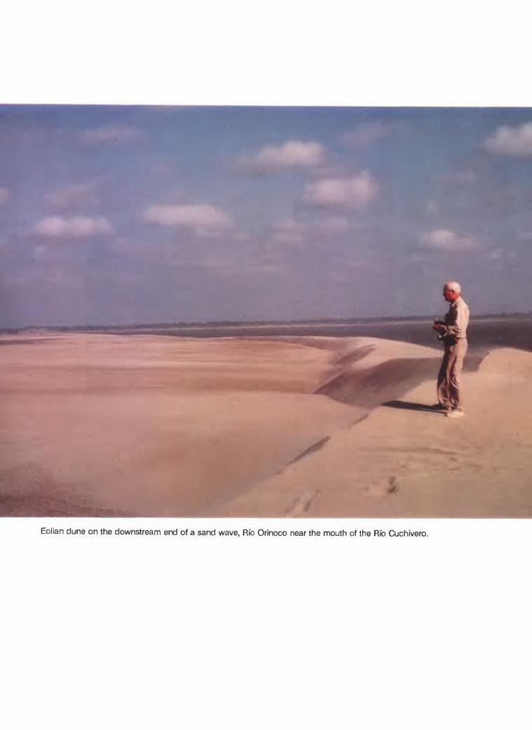
Eolian dune on the downstream end of a sand wave, Rfo Orinoco near the mouth of the Rfo Cuchivero.
Chapter B
Sedimentary Structures and Textures of Rfo Orinoco Channel Sands, Venezuela and Colombia
By EDWIN D. McKEE
Prepared in cooperation with the Venezuelan Ministerio del Ambiente y de los Recursos Naturales Renovables
U.S. GEOLOGICAL SURVEY WATER-SUPPLY PAPER 2326
THE WATERS AND SEDIMENTS OF THE RIO ORINOCO AND ITS MAJOR TRIBUTARIES, VENEZUELA AND COLOMBIA
DEPARTMENT OF THE INTERIOR
MANUEL LUJAN, JR., Secretary
U.S. GEOLOGICAL SURVEY
Dallas L Peck, Director
Any use of trade names in this report is for descriptive purposes only and does not imply endorsement by the U.S. Geological Survey.
UNITED STATES GOVERNMENT PRINTING OFFICE: 1989
For sale by theBooks and Open-File Reports SectionU.S. Geological SurveyFederal Center, Box 25425Denver, CO 80225
Library of Congress Cataloging-in-Publication Data
McKee, Edwin Dinwiddie, 1906-1984Sedimentary structures and textures of Rfo Orinoco channel sands,
Venezuela and Colombia
(U.S. Geological Survey water-supply paper; 2326-B )"Prepared in cooperation with the Venezuelan Ministerio del Ambiente y de
los Recursos Naturales Renovables.Bibliography: p.Supt. of Docs, no.: I 19.13:2326-61. Sedimentation and deposition Venezuela Orinoco River.I. Venezuela, Ministerio del Ambiente y de los Recursos Naturales
Renovables. II. Title. III. Series. QE571.M43 1989 551.3'55'-0987 88-600423
FOREWORD
The Rio Orinoco is one of the great rivers of the world. It drains about 900,000 square kilometers and discharges to the ocean an average flow in excess of 36,000 cubic meters per second and an average sediment load of about 7,600 kilograms per second (240 million tonnes per year), ranking it third largest in the world in terms of flow to the oceans and sixth largest in terms of sediment loads. It is an international river, draining parts of Colombia and Venezuela, and forming the boundary between these two nations along some 300 kilometers of its course.
The basin is rich in natural resources, containing extensive fields of petroleum and natural gas, including the largest proven reserve of heavy crude oil in the world, and rich deposits of bauxite, iron ore, gold, diamonds, and other mineral wealth. Its renewable resources include its forests, fish and wildlife, agriculture and grazing lands, and most important, its waters. The basin is not developed to any great extent; large parts of the watershed still are undisturbed. Although it accounts for 70 percent of the nation's land, it supports only 5 percent of the population. This situation, though, is likely to change in the near future. The development of the Rio Orinoco's natural resources is the key to Venezuela's future.
In 1981, Project Orinoco-Apure was organized under the auspices of the Venezuelan Ministerio del Ambiente y de los Recursos Naturales Renovables to serve as the focal point and coordinating body for scientific studies of the resources of the basin and for feasibility studies and preliminary planning of its development. An important part of the project effort was directed to investigations of the basin's water resources. In 1982, the United States Geological Survey and the Venezuelan Ministerio del Ambiente y de los Recursos Naturales Renovables agreed to collaborate in a series of scientific studies of the Rio Orinoco and its major tributaries. A strong foundation already had been laid for the hydrology of the basin with the establishment of a gaging and sediment sampling program in 1965, but by 1980, the program had been substantially reduced. Data on the bed sediments of the rivers and on the sediment transport were especially sparse. The main emphasis of the collaboration therefore was directed toward sediment studies. The studies had three principal objectives: (1) to develop and test new technology for measuring the water and sediment discharge of large tropical rivers, (2) to determine the characteristics of the bed material and suspended sediment of the major rivers of the basin, and (3) to provide measurements and samples that along with the existing hydrologic information would provide a set of baseline scientific data against which future changes in the basin could be measured. Between March 1982, and June 1985, seven major campaigns to collect data along the river and in the major tributaries were completed, and the collaboration expanded considerably to include participation of engineers, scientists, and consultants from universities, private enterprises, and other government agencies of Venezuela, Colombia, and the United States.
At the beginning of the collaboration, it was agreed that the results of these studies would be made available to the scientific community. A few short papers have been published in symposium proceedings and in technical journals, but the main results and all the basic data are contained in this series of reports. Each chapter is self-contained; taken together, they provide comprehensive data and analyses of the waters and sediments of the Rio Orinoco and its major tributaries in Venezuela and Colombia. The results of these studies should be of interest and a value to anyone who is concerned with large tropical rivers.
Dallas L. PeckDirectorUnited States Geological Survey
Guillermo Colmenares F. MinisterMinisterio del Ambiente y de los
Recursos Naturales Renovables Republica de Venezuela
Foreword
CONTENTS
Foreword vAbstract BlIntroduction BlTerminology used for sedimentary structures Bl
Cross-stratification B3Bedforms B3
Sand-wave deposits B5 Cross-stratification B7 Miscellaneous sedimentary structures BIO
Depositional features BIOContorted structures BIOClimbing megaripples B12Additional sedimentary features B12
Texture B14Grain-size distribution B14Sorting of sand B16
References cited B23
FRONTISPIECE
Eolian dune on the downstream end of a sandwave, Rio Orinoco near the mouth of the Rio Cuchivero
FIGURES
1. Map showing location of study reach along Rio Orinoco, Venezuela B22. Photographs showing two views of tabular-planar structures in trench with
foresets dipping downstream; left bank of Rio Orinoco at Musinacio B33. Profile of sand-wave deposits and diagrams showing tabular-planar structures
exposed in trenches on bar parallel to direction of river flow; Rio Orinoco at Curiquima B4
4. Profile of sand-wave deposits and diagrams showing sedimentary structures at crests of bar parallel to direction of river flow; Rio Orinoco upstream from Las Ventanas, 2 river kilometers upstream from mouth of Rio Suapure B5
5. Profile of sand-wave deposits showing positions of crests and intercrest areas, and trench locations on bar parallel to direction of river flow; Rio Orinoco near Isla Babilla Flaca B5
6. Profile of sand-wave deposits showing positions of crests and intercrest areas, and trench location on bar parallel to direction of river flow with diagrams showing cross-stratification patterns in each; Rio Orinoco at Musinacio B6
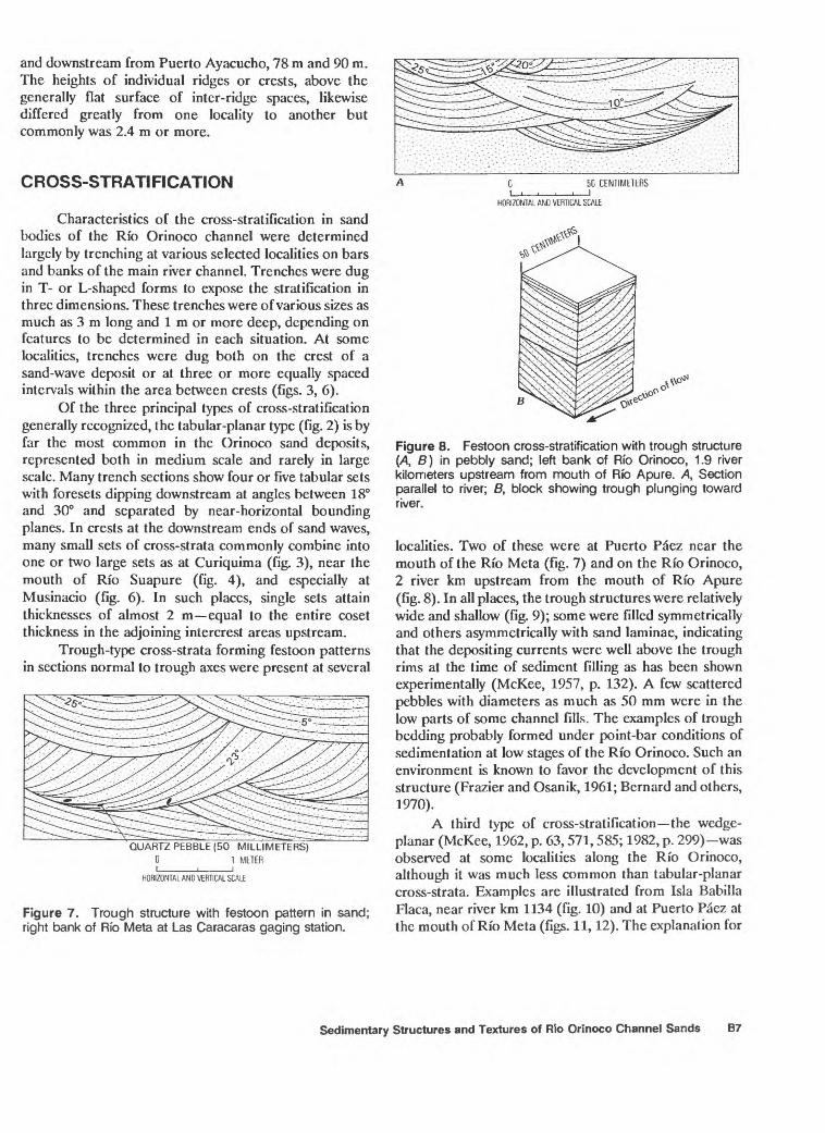
7. Diagram showing trough structure with festoon pattern in sand; right bank of Rio Meta at Las Caracaras gaging station B7
8. Diagrams showing festoon cross-stratification with trough structure in pebbly sand; left bank of Rio Orinoco, 1.9 river kilometers upstream from mouth of Rio Apure B7
Contents VII
9. Photographs showing two views of trough structure with festoon pattern in trench; right bank of Rio Meta, 2 river kilometers downstream from Las Caracaras gaging station B8
10. Profile of sand-wave deposits and diagrams showing cross-strata patternsexposed in trenches at crests and between crests on bar parallel to direction of river flow; right channel of Rio Orinoco near Isla Babilla Flaca B9
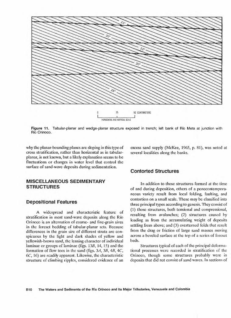
11. Diagram showing tabular-planar and wedge-planar structures exposed in trench; left bank of Rio Meta at junction with Rio Orinoco BIO
12. Photographs showing two views of wedge-planar cross-strata exposed in trench; left bank of Rio Orinoco near Puerto Paez fill
13. Diagrams showing minor sedimentary structures exposed on face of bar; center of Rio Orinoco, 2 river kilometers downstream from Puerto Ayacucho B12
14. Photographs showing lenticular laminae, lenses or flow toes, folds, andlow-angle faults in foresets of sand-wave deposits; center bar of Rio Orinoco, 2 river kilometers downstream from Puerto Ayacucho B13
15. Diagram showing alternating coarse- and fine-grained sand laminae and lenses in sand-wave deposits; Rio Orinoco at Isla Ceiba F14
16. Photograph showing sand-flow toes at base of foresets in sand-wave deposits; right bank of Rio Orinoco, 2 river kilometers downstream from Puerto Ayacucho B15
17. Diagram showing penecontemporaneous sag or fold, probably caused byloading during deposition; right bank of Rio Orinoco near Curiquima B16
18. Diagram showing recumbent fold, probably result of drag by sand load during deposition of overlying foresets, with upriver-dipping eolian foresets above sand-wave deposits dipping down river; Rio Cuchivero near mouth B16
19. Photographs showing two views of large-scale climbing megaripple structure on face of sand bar; right bank of Rio Orinoco upstream from Rio Cuchivero B17
20. Diagrams showing lenses and flat beds of organic matter amongtabular-planar sets of sand-wave deposits; left bank of Rio Parguaza near mouth B18
21. Diagram showing organic matter (leaves and twigs) among tabular-planar sets of cross-stratified sand-wave deposits; left bank of Rio Orinoco at mouth of Rio Meta B18
22. Photograph of eolian dune on surface of sand-wave deposits; Rio Orinoco at Punta Brava, 11 river kilometers upstream from Rio Cuchivero B19
23. Photograph of barchan dune on sand bar; Rio Orinoco at mouth of Rio Cuchivero B19
24. Diagram showing cross-stratification of eolian deposits above sand-wave deposits exposed in trench; right bank of Rio Orinoco at mouth of Rio Cuchivero B19
TABLES
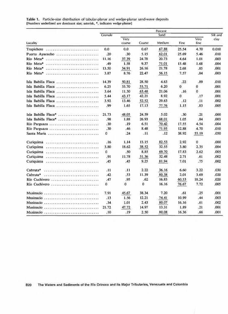
1. Particle-size distribution of tabular-planar and wedge-planar sand-wave deposits B20
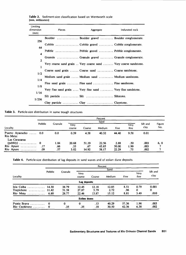
2. Sediment-size classification based on Wentworth scale B213. Particle-size distribution in some trough structures B214. Particle-size distribution of lag deposits in sand waves and of eolian dune
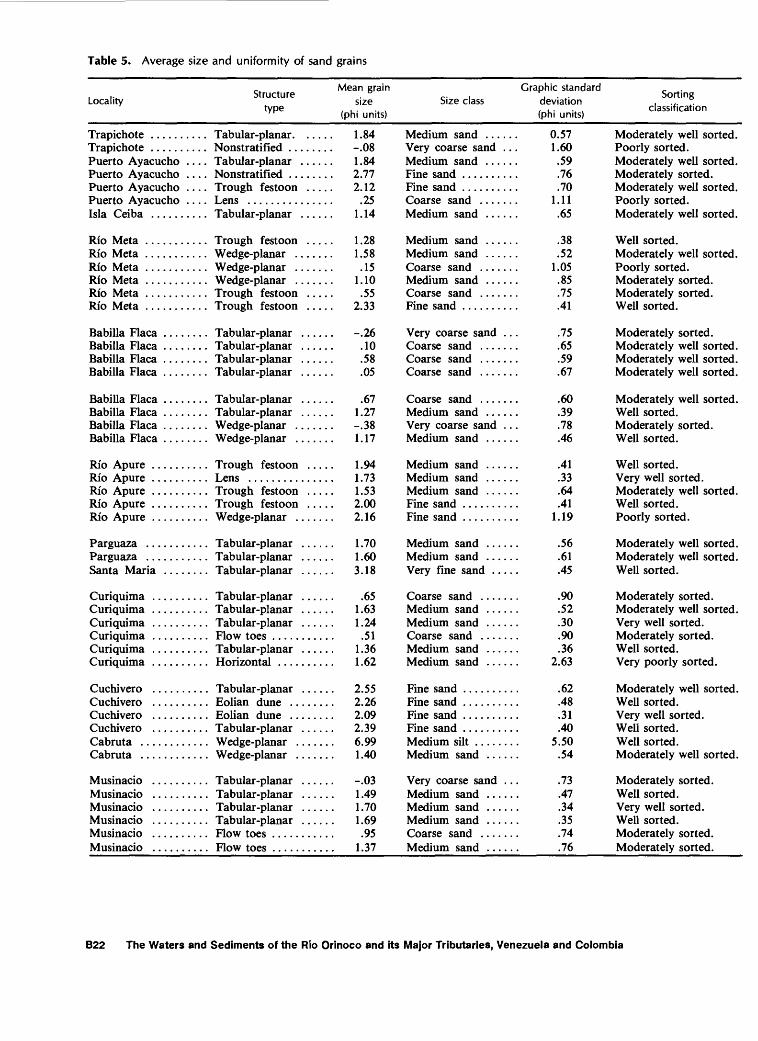
deposits B215. Average size and uniformity of sand grains B22
VIM Contents
Sedimentary Structures and Textures of Rio Orinoco Channel Sands
By Edwin D. McKee
ABSTRACT
Most sedimentary structures represented in sand bodies of the Rfo Orinoco are tabular-planar cross-strata which, together with some wedge-planar cross-strata, are the products of sand-wave deposition. Locally, in areas of river meander where point bars characteristically form, trough structures forming festoon patterns are numerous. At a few localities, sets of nearly horizontal strata occur between tabular-planar sets and are interpreted to be the deposits of very fast currents of the upper flow regime; elsewhere, uncommon lenses and beds of silt, clay, or organic matter consisting of leaves and twigs, seem to be the result of quiet-water settling through gravity.
By far the most common grain size represented in the tabular-planar and wedge-planar cross-strata of the sand- wave deposits is medium sand (1/4-1/2 millimeter) as deter mined by screen analyses. Many samples, however, also contain moderate quantities of coarse or very coarse sand. Eolian dunes on top of the sand-wave deposits are dominantly fine grained. The river channel sands were determined to be largely moderately well sorted, although in some places they were mostly well sorted, and in others, mostly moderately sorted.
INTRODUCTION
Sedimentary structures and textures of Rio Ori noco channel sands in Venezuela were studied during March 1983, when the river was at low stage. The project was conducted as one of a series of studies on hydrology, water chemistry, and other aspects of the Rio Orinoco, most of which are described and discussed in chapters of
U.S. Geological Survey Water-Supply Paper 2326. Work was done largely during a trip on the barge Duida from Puerto Ayacucho downriver to Ciudad Guayana (fig. 1). Some preliminary work was done in small boats up stream as far as Santa Barbara, but mostly the studies were conducted along the banks and on emergent bars accessible from the Duida.
The sedimentary-structures work was conducted contemporaneously with other river studies wherever opportunity permitted. Carl Nordin, in general charge of the program, and Robert Meade and Clare Cranston, of the U.S. Geological Survey, contributed greatly to the sedimentary studies, in addition to their individual assign ments. Two groups of Venezuelan geologists and hydrologists participated in the detailed program of trenching, sampling, and measuring. One group, con sisting of David Perez Hernandez, Antonio Ahogado, and Ricardo Smith, helped on the upstream reach as far downstream as Cabruta; this group was then succeeded by Alfredo DeLeon and Alfred Viloria. Appreciative thanks for assistance is due to all of these men. For help in the work upstream from Puerto Ayacucho, thanks are extended to Lois and Omar Hernandez. Finally, for assistance and encouragement involving the entire research project, thanks are given to Dr. Abel Mejfa, Project Coordinator.
TERMINOLOGY USED FOR SEDIMENTARY STRUCTURES
Definitions of terms adopted for use in the accompanying report are largely those used in the
Sedimentary Structures and Textures of Rio Orinoco Channel Sands B1
San Fernando de Atabapo o';O ^ -
Trapichote
100 MILES
Figure 1. Location of study reach along Rfo Orinoco, Venezuela.
monograph of the Supai Group of Grand Canyon glossary. This list is not intended to be inclusive, but(McKee, 1982). For the convenience of the reader some rather a list of selected terms that seem to be ambiguousof the more common terms, especially those involving and in a number of examples have been used in morequantitative designations, are presented here as a than one way in recent literature.
B2 The Waters and Sediments of the Rio Orinoco and its Major Tributaries, Venezuela and Colombia
Cross-Stratification (Modified from McKee and Weir, 1953)
Scale as applied to foresct length.1. Small scale less than 0.33 m.2. Medium scale about 0.33 to 6 m.3. Large scale greater than 6 m. Classes of dip angles (foreset surfaces).1. High-angle strata dip 20° or more.2. Low-angle strata dip less than 20°. Basic types of cross-strata. Based primarily on the character of the lower bounding surface of each set of cross-strata, and, secondarily, on the shape of each set of cross-strata.1. Tabular-planar contain bounding surfaces
that are virtually parallel (fig. 2).2. Wedge-planar contain planar bounding sur
faces that converge.3. Lenticular contain one or more bounding
surfaces that are curving and not planar.4. Trough structure the lower bounding surface
is trough-shaped; laminae filling the trough may be symmetrical or asymmetrical.
5. Festoon troughs group of troughs each having a partially dissected underlying trough or troughs with festoon pattern.
Bedforms
Classification. Considerable confusion exists concerning terminology for rhythmic bedforms formed in cohesionless sediment by water currents as stated by Miall (1977, p. 33). The size, shape, and internal structure are features most commonly used to differ entiate kinds of bedforms, and three or four principal classes generally are recognized: for example, three forms adopted for reversing tidal currents (Alien, 1979), and four forms for fluvial deposits (Coleman, 1969). Furthermore, many names are synonymous in part or in total.
Sand wai'cs. As defined by Friedman and Sanders (1978, p. 570), these are rhythmic bedforms larger than ripples, formed by water currents in cohesionless sedi ments. In the classification of Coleman (1969, table VI), they are shown as having greater wave height and wave length, in general, than either megaripples or aqueous dunes and are characterized by long-crested, parallel ridges that in plan view range from relatively straight or gently curved to moderately sinuous. Because they grade in size, shape, and ripple index from typical aqueous
. -(t - .*"*#" ' V" ' ' * -j. ^^?i " "
- .>^^"t^^i\*^"ft?Sfe|^v? -Vl^*;
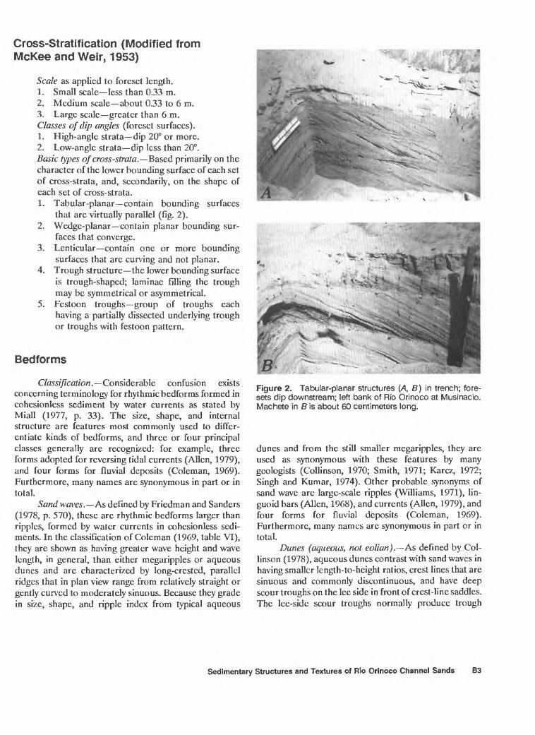
Figure 2. Tabular-planar structures (A, B) in trench; fore- sets dip downstream; left bank of Rfo Orinoco at Musinacio. Machete in B is about 60 centimeters long.
dunes and from the still smaller megaripples, they are used as synonymous with these features by many geologists (Collinson, 1970; Smith, 1971; Karcz, 1972; Singh and Kumar, 1974). Other probable synonyms of sand wave are large-scale ripples (Williams, 1971), lin- guoid bars (Alien, 1968), and currents (Alien, 1979), and four forms for fluvial deposits (Coleman, 1969). Furthermore, many names are synonymous in part or in total.
Dunes (aqueous, not eolian). As defined by Col linson (1978), aqueous dunes contrast with sand waves in having smaller length-to-height ratios, crest lines that are sinuous and commonly discontinuous, and have deep scour troughs on the lee side in front of crest-line saddles. The lee-side scour troughs normally produce trough
Sedimentary Structures and Textures of Rio Orinoco Channel Sands B3
70 MFTFRC: R 7O METERS 70 METERS 3 METERSj^^SS^ ^^r
50 100 CEMTIMETERS
I Coarse sand lens in matrix of fine to medium sand
HORIZONTAL AND VERTICAL SCALE
EXPLANATION
x>H Medium sand Silt and mud
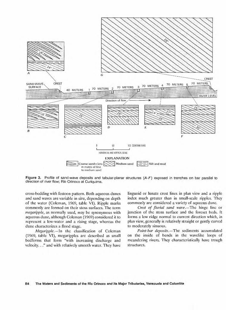
Figure 3. Profile of sand-wave deposits and tabular-planar structures (A-F) exposed in trenches on bar parallel to direction of river flow; Rib Orinoco at Curiquima.
cross-bedding with festoon pattern. Both aqueous dunes and sand waves are variable in size, depending on depth of the water (Coleman, 1969, table VI). Ripple marks commonly are formed on their stoss surfaces. The term tnegaripple, as normally used, may be synonymous with aqueous dune, although Coleman (1969) considered it to represent a low-water and a rising stage, whereas the dune characterizes a flood stage.
Megaripple. ln the classification of Coleman (1969, table VI), megaripples are described as small bedforms that form "with increasing discharge and velocity.. ." and with relatively smooth water. They have
linguoid or lunate crest lines in plan view and a ripple index much greater than in small-scale ripples. They commonly are considered a variety of aqueous dune.
Crest of fluvial sand wove. The hinge line or junction of the stoss surface and the foreset beds. It forms a low ridge normal to current direction which, in plan view, generally is relatively straight or gently curved to moderately sinuous.
Point-bar deposits. The sediments accumulated on the inside of bends in the wavelike loops of meandering rivers. They characteristically have trough structures.
B4 The Waters and Sediments of the Rio Orinoco and its Major Tributaries, Venezuela and Colombia
CREST310 METERS
/SAND-WAVE / SURFACE
RIVER LEVEL
EXPLANATION
Coarse and fine sand
HORIZONTAL AND VERTICAL SCALE
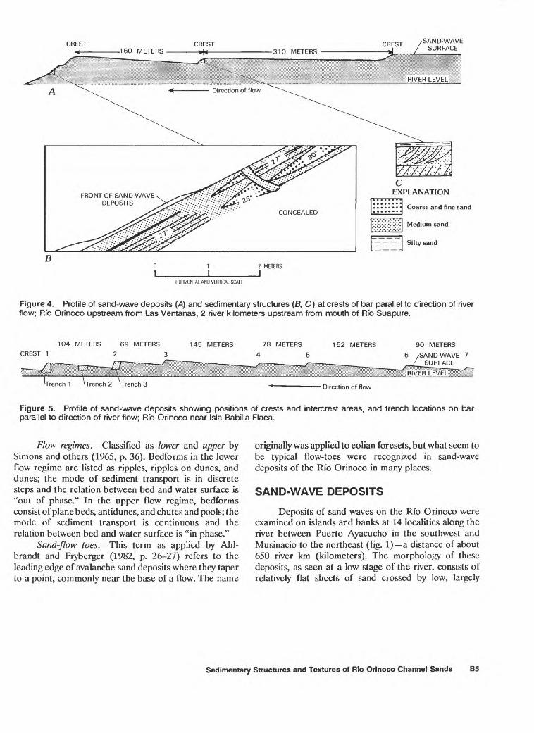
Figure 4. Profile of sand-wave deposits (A) and sedimentary structures (B, C) at crests of bar parallel to direction of river flow; Rfo Orinoco upstream from Las Ventanas, 2 river kilometers upstream from mouth of Rfo Suapure.
104 METERSCREST 1
69 METERS
2 3145 METERS 78 METERS
4 5152 METERS 90 METERS
6 /SAND-WAVE 7
Direction of flow
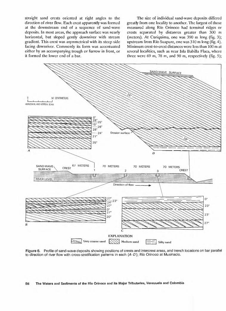
Figure 5. Profile of sand-wave deposits showing positions of crests and intercrest areas, and trench locations on bar parallel to direction of river flow; Rfo Orinoco near Isla Babilla Flaca.
Flow regimes. Classified as lower and upper by Simons and others (1965, p. 36). Bedforms in the lower flow regime are listed as ripples, ripples on dunes, and dunes; the mode of sediment transport is in discrete steps and the relation between bed and water surface is "out of phase." In the upper flow regime, bedforms consist of plane beds, antidunes, and chutes and pools; the mode of sediment transport is continuous and the relation between bed and water surface is "in phase."
Sand-flow toes. This term as applied by Ahl- brandt and Fryberger (1982, p. 26-27) refers to the leading edge of avalanche sand deposits where they taper to a point, commonly near the base of a flow. The name
originally was applied to eolian foresets, but what seem to be typical flow-toes were recognized in sand-wave deposits of the Rio Orinoco in many places.
SAND-WAVE DEPOSITS
Deposits of sand waves on the Rfo Orinoco were examined on islands and banks at 14 localities along the river between Puerto Ayacucho in the southwest and Musinacio to the northeast (fig. 1) a distance of about 650 river km (kilometers). The morphology of these deposits, as seen at a low stage of the river, consists of relatively flat sheets of sand crossed by low, largely
Sedimentary Structures and Textures of Rio Orinoco Channel Sands B5
straight sand crests oriented at right angles to the direction of river flow. Each crest apparently was formed at the downstream end of a sequence of sand-wave deposits. In most areas, the approach surface was nearly horizontal, but sloped gently downriver with stream gradient. This crest was asymmetrical with its steep side facing downriver. Commonly its form was accentuated either by an accompanying trough or furrow in front, or it formed the lower end of a bar.
The size of individual sand-wave deposits differed greatly from one locality to another. The largest of those measured along Rio Orinoco had terminal ridges or crests separated by distances greater than 300 m (meters). At Curiquima, one was 390 m long (fig. 3); upstream from Rio Suapure, one was 310 m long (fig. 4). Minimum crest-to-crest distances were less than 100 m at several localities, such as near Isla Babilla Flaca, where three were 69 m, 78 m, and 90 m, respectively (fig. 5);
____ EXPLANATION
pSS5>fcJ Very coarse sand [s^XN^ Medium sand |~ | Silty sand
Figure 6. Profile of sand-wave deposits showing positions of crests and intercrest areas, and trench locations on bar parallel to direction of river flow with cross-stratification patterns in each (A-D); Rib Orinoco at Musinacio.
B6 The Waters and Sediments of the Rio Orinoco and its Major Tributaries, Venezuela and Colombia
and downstream from Puerto Ayacucho, 78 m and 90 m. The heights of individual ridges or crests, above the generally flat surface of inter-ridge spaces, likewise differed greatly from one locality to another but commonly was 2.4 m or more.
CROSS-STRATIFICATION
Characteristics of the cross-stratification in sand bodies of the Rio Orinoco channel were determined largely by trenching at various selected localities on bars and banks of the main river channel. Trenches were dug in T- or L-shaped forms to expose the stratification in three dimensions. These trenches were of various sizes as much as 3 m long and 1 m or more deep, depending on features to be determined in each situation. At some localities, trenches were dug both on the crest of a sand-wave deposit or at three or more equally spaced intervals within the area between crests (figs. 3, 6).
Of the three principal types of cross-stratification generally recognized, the tabular-planar type (fig. 2) is by far the most common in the Orinoco sand deposits, represented both in medium scale and rarely in large scale. Many trench sections show four or five tabular sets with foresets dipping downstream at angles between 18° and 30° and separated by near-horizontal bounding planes. In crests at the downstream ends of sand waves, many small sets of cross-strata commonly combine into one or two large sets as at Curiquima (fig. 3), near the mouth of Rio Suapure (fig. 4), and especially at Musinacio (fig. 6). In such places, single sets attain thicknesses of almost 2 m equal to the entire coset thickness in the adjoining intercrest areas upstream.
Trough-type cross-strata forming festoon patterns in sections normal to trough axes were present at several
QUARTZ PEBBLE (50 MILLIMETERS)0 1 METER
HORIZONTAL AND VERTICAL SCALE
HORIZONTAL AND VERTICAL SCALE
Figure 7. Trough structure with festoon pattern in sand; right bank of Rio Meta at Las Caracaras gaging station.
Figure 8. Festoon cross-stratification with trough structure (A, B) in pebbly sand; left bank of Rfo Orinoco, 1.9 river kilometers upstream from mouth of Rio Apure. A, Section parallel to river; B, block showing trough plunging toward river.
localities. Two of these were at Puerto Paez near the mouth of the Rio Meta (fig. 7) and on the Rio Orinoco, 2 river km upstream from the mouth of Rio Apure (fig. 8). In all places, the trough structures were relatively wide and shallow (fig. 9); some were filled symmetrically and others asymmetrically with sand laminae, indicating that the depositing currents were well above the trough rims at the time of sediment filling as has been shown experimentally (McKee, 1957, p. 132). A few scattered pebbles with diameters as much as 50 mm were in the low parts of some channel fills. The examples of trough bedding probably formed under point-bar conditions of sedimentation at low stages of the Rio Orinoco. Such an environment is known to favor the development of this structure (Frazier and Osanik, 1961; Bernard and others, 1970).
A third type of cross-stratification the wedge- planar (McKee, 1962, p. 63,571,585; 1982, p. 299)-was observed at some localities along the Rio Orinoco, although it was much less common than tabular-planar cross-strata. Examples are illustrated from Isla Babilla Flaca, near river km 1134 (fig. 10) and at Puerto Paez at the mouth of Rio Meta (figs. 11,12). The explanation for
Sedimentary Structures and Textures of Rio Orinoco Channel Sands B7
Figure 9. Trough structures with festoon pattern (A 6) in trench; right bank of Rfo Meta, 2 river kilometers downstream from Las Caracaras gaging station.
B8 The Waters and Sediments of the Rio Orinoco and its Major Tributaries, Venezuela and Colombia
NORMAL TO CREST PARALLEL TO CREST
HORIZONTAL AND VERTICAL SCALE
EXPLANATION
Very coarse sand Medium sand Silty sand
Figure 10. Profile of sand-wave deposits showing cross-strata patterns (A-E) exposed in trenches at crests and between crests on bar parallel to direction of river flow; right channel of Rio Orinoco near Isla Babilla Flaca.
Sedimentary Structures and Textures of Rio Orinoco Channel Sands B9
50 CENTIMETERS
HORIZONTAL AND VERTICAL SCALE
Figure 11. Tabular-planar and wedge-planar structure exposed in trench; left bank of Rio Meta at junction with Rio Orinoco.
why the planar-bounding planes are sloping in this type of cross stratification, rather than horizontal as in tabular- planar, is not known, but a likely explanation seems to be fluctuations or changes in water level that control the surface of sand-wave deposits during sedimentation.
MISCELLANEOUS SEDIMENTARY STRUCTURES
Depositional Features
A widespread and characteristic feature of stratification in most sand-wave deposits along the Rio Orinoco is an alternation of coarse- and fine-grain sizes in the foreset bedding of tabular-planar sets. Because differences in the grain size of different strata are con spicuous by the light and dark shades of yellow and yellowish-brown sand, the lensing character of individual laminae or groups of laminae (figs. 13B, 14, 15) and the formation of flow toes in the sand (figs. 3A, 3B, 4B, 4C, 6C, 16) are readily apparent. Likewise, the characteristic structure of climbing ripples, considered evidence of an
excess sand supply (McKee, 1965, p. 81), was noted at several localities along the banks.
Contorted Structures
In addition to those structures formed at the time of and during deposition, others of a penecontempora- neous variety result from local folding, faulting, and contortion on a small scale. These may be classified into three principal types according to genesis. They consist of (1) those structures, both tensional and compressional, resulting from avalanches; (2) structures caused by loading as from the accumulating weight of deposits settling from above; and (3) overturned folds that result from the drag or friction of large sand masses moving across a beveled surface at the top of a series of foreset beds.
Structures typical of each of the principal deforma- tional processes were recorded in stratification of the Orinoco, though some structures probably were in deposits that did not consist of sand waves. In sections of
B10 The Waters and Sediments of the Rio Orinoco and its Major Tributaries, Venezuela and Colombia
Figure 12. Wedge-planar cross-strata (A, B) exposed in trench; left bank of Rfo Orinoco near Puerto Paez.
Sedimentary Structures and Textures of Rio Orinoco Channel Sands B11
20 CENTIMETERS J
HORIZONTAL AND VERTICAL SCALE
EXPLANATION
Coarse sand
Fine sand
Figure 13. Minor sedimentary structures (A-E) exposed on face of bar; center of Rfo Orinoco, 2 river kilometers downstream from Puerto Ayacucho.
a sand bar about 2 km downstream from Puerto Ayacu cho, small examples of sags from loading (figs. 13/4, 17), of shattered and contorted folds (fig. 13C), and of irregular lensing (fig. 135) were noted in laminae of coarse sand among the fine sand laminae. These were formed on foresets, probably the result of avalanches. Small convolute structures such as commonly form in the upper layers of loose sand as a result of sediment loading (McKee and others, 1967, p. 840) also were observed at this locality (fig. 13E).
Near the mouth of Rio Cuchivero, the beveled lower part of a typical recumbent fold, of the type that forms from drag by a mass of sand moving across foresct tops (McKee, 1962, p. 553), was recorded (fig. 18). This feature is considered good evidence of flood conditions during which water transports a heavy load of sediment across the sand surface.
Climbing Megaripples
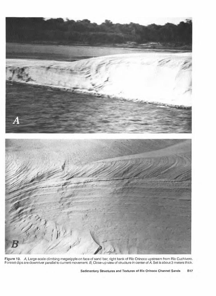
On a large sand bar along the right bank of the Orinoco, near the mouth of Rio Cuchivero, an excep tionally fine example of climbing megaripple structure on a large scale was exposed by erosion (fig. 19). Two sets of 27°-dipping foresets were measured in the bank above river level and the corresponding low-angle beds (top- sets) of the upcurrcnt side of each megaripple formed nearly horizontal planes. This structure clearly illustrates the rapid rate of sedimentation and the large quantity of sand transported by the stream at the time of deposition.
Additional Sedimentary Features
Relatively few features affecting the remarkably uniform, primary stratification and cross-stratification of the Orinoco channel deposits have been noted in the many trenches dug at various localities. Other than the penecontemporaneous structures already described, most exceptions to the uniformity consist of (1) incor porated organic matter; (2) partial destruction of laminae by boring or burrowing animals, or from plant growth; and (3) reworking of water-deposited sediments by subsequent current action or by the wind.
Organic matter, largely in the form of leaves, twigs, and other debris trapped in pockets or trough-like depres sions adjacent to sand-wave deposits have accumulated as lenses or irregular beds. Such deposits were observed at various localities along the Orinoco, but apparently are not common in the channel sands. On the left bank of the Rio Parguaza near its mouth, small lenses and thin flat beds of black carbonaceous matter (partially decom posed leaves) were noted between sets of tabular-planar sand in which foresets dipped uniformly between 15° and 25° (fig. 20). At Rio Meta near Puerto Paez, some relatively thick black beds, consisting largely of twigs and plant debris, likewise were conspicuous between sand- wave deposits consisting of tabular-planar cross-beds of yellowish sand (fig. 21). Dips of foresets in these sands ranged from 20° to 28° downstream.
Partial destruction through bioturbation of strati fication patterns among sand-wave deposits of the Rio Orinoco seems to be a relatively uncommon feature, especially when compared with many other environments of sand deposition. The general scarcity of burrowing and boring organisms probably results from impermanence of river sand bars. Constant changes in river discharge and in velocity and direction of current flow make habitats for many organisms unstable. At Isla Babilla Flaca, near river km 1134, however, many vertical and high-angle tubes, about 1 cm in diameter, were noted penetrating foresets that dipped at 19° and 20° (fig. 10D) throughout a limited area. Elsewhere along the river, little evidence of laminae disruption by organisms was noted.
The reworking of sand-wave deposits by wind was a conspicuous feature on many of the large bars and some of the small ones. Eolian dunes of barchanoid type formed on top of the otherwise flat surfaces of sand-wave deposits. Examples were near Cabruta; at Punta Brava, 11 river km upstream from Rio Cuchivero (fig. 22); and at the mouth of Rio Cuchivero where they were 3.4 m
B12 The Waters and Sediments of the Rio Orinoco and its Major Tributaries, Venezuela and Colombia
'"%* ^\ **s~ * -«\+
Figure 14. X\, Lenticular laminae and lenses or flow toes of coarse sand (dark) in foresets of sand-wave deposits, and B, folds and low-angle faults in the same deposits. Center bar of Rfo Orinoco, 2 river kilometers downstream from Puerto Ayacucho.
Sedimentary Structures and Textures of Rio Orinoco Channel Sands B13
20 CENTIMETERS J
HORIZONTAL AND VERTICAL SCALE
EXPLANATION
Very coarse sand and granules
Medium sand
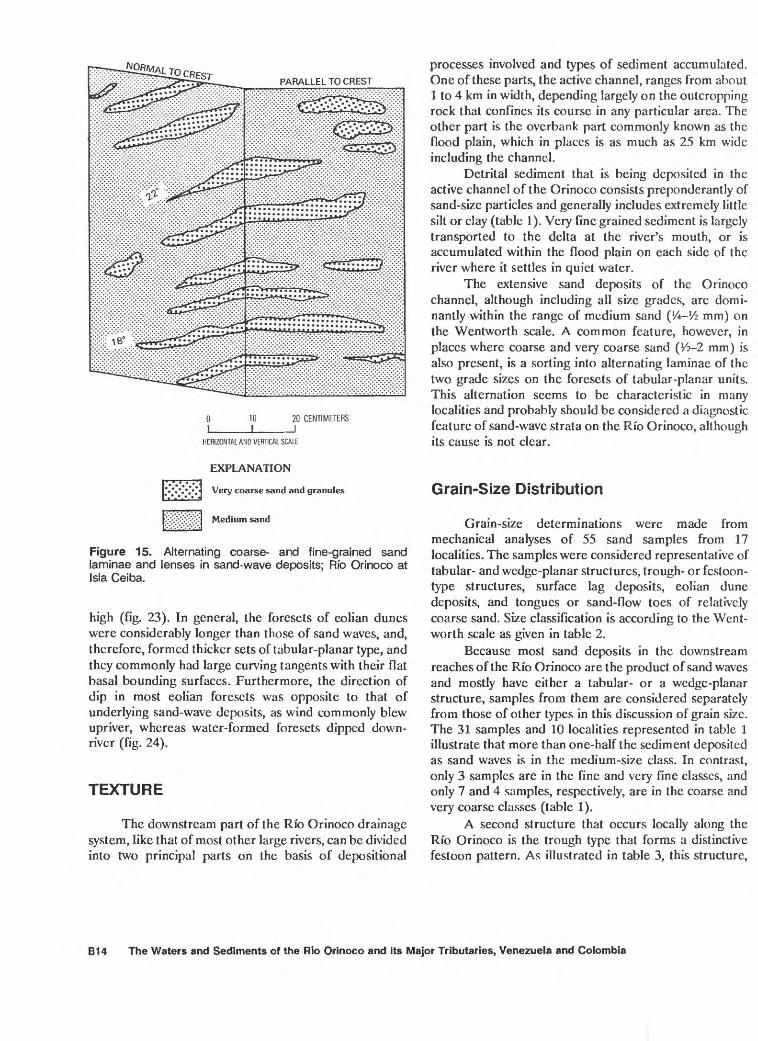
Figure 15. Alternating coarse- and fine-grained sand laminae and lenses in sand-wave deposits; Rib Orinoco at Isla Ceiba.
high (fig. 23). In general, the foresets of eolian dunes were considerably longer than those of sand waves, and, therefore, formed thicker sets of tabular-planar type, and they commonly had large curving tangents with their flat basal bounding surfaces. Furthermore, the direction of dip in most eolian foresets was opposite to that of underlying sand-wave deposits, as wind commonly blew upriver, whereas water-formed foresets dipped down river (fig. 24).
TEXTURE
The downstream part of the Rio Orinoco drainage system, like that of most other large rivers, can be divided into two principal parts on the basis of depositional
processes involved and types of sediment accumulated. One of these parts, the active channel, ranges from about 1 to 4 km in width, depending largely on the outcropping rock that confines its course in any particular area. The other part is the overbank part commonly known as the flood plain, which in places is as much as 25 km wide including the channel.
Detrital sediment that is being deposited in the active channel of the Orinoco consists preponderantly of sand-size particles and generally includes extremely little silt or clay (table 1). Very fine grained sediment is largely transported to the delta at the river's mouth, or is accumulated within the flood plain on each side of the river where it settles in quiet water.
The extensive sand deposits of the Orinoco channel, although including all size grades, are domi- nantly within the range of medium sand (Vt-Vz mm) on the Wentworth scale. A common feature, however, in places where coarse and very coarse sand (Vz-2 mm) is also present, is a sorting into alternating laminae of the two grade sizes on the foresets of tabular-planar units. This alternation seems to be characteristic in many localities and probably should be considered a diagnostic feature of sand-wave strata on the Rio Orinoco, although its cause is not clear.
Grain-Size Distribution
Grain-size determinations were made from mechanical analyses of 55 sand samples from 17 localities. The samples were considered representative of tabular- and wedge-planar structures, trough- or festoon- type structures, surface lag deposits, eolian dune deposits, and tongues or sand-flow toes of relatively coarse sand. Size classification is according to the Went worth scale as given in table 2.
Because most sand deposits in the downstream reaches of the Rio Orinoco are the product of sand waves and mostly have either a tabular- or a wedge-planar structure, samples from them are considered separately from those of other types in this discussion of grain size. The 31 samples and 10 localities represented in table 1 illustrate that more than one-half the sediment deposited as sand waves is in the medium-size class. In contrast, only 3 samples are in the fine and very fine classes, and only 7 and 4 samples, respectively, are in the coarse and very coarse classes (table 1).
A second structure that occurs locally along the Rio Orinoco is the trough type that forms a distinctive festoon pattern. As illustrated in table 3, this structure,
B14 The Waters and Sediments of the Rio Orinoco and its Major Tributaries, Venezuela and Colombia
^V:.. v-, %V*;jf ?& ' ^*^2
Figure 16. Sand-flow toes at base of foresets in sand-wave deposits; right bank of Rfo Orinoco, 2 river kilometers downstream from Puerto Ayacucho. Scale is in inches. Photograph by Lois Hernandez.
which generally is considered the result of point-bar formation in areas where a stream meanders, is incon sistent in its grain size and commonly includes scattered granules and pebbles, especially near the trough bottoms. No one grain size seems to be dominant among the sands of these festoons.
Particles of very coarse sand and of granule- and pebble-size constitute a conspicuous though relatively minor part of many sand-wave deposits along Rfo Orinoco. They occur mostly as scattered grains, inter preted as lags, on bar surfaces, although in some vertical faces they form lenses (fig. 15) or concentrations filling irregular depressions. The percentages of size grades in lag samples from three representative localities along the river are shown in table 4 and illustrate typical coarse fractions.
At the opposite extreme in grain size are the sands of eolian dunes that commonly form on the surfaces of sand bars (figs. 22, 23). These wind-blown sands apparently were derived largely from the underlying sand-wave deposits and are composed mostly of fine grains (Vs-Vi mm) and to a lesser extent of medium grains (1A-V2 mm). Relatively few of either coarser or finer sizes are present as shown in table 4. Thus, sorting (table 5) is very good even better than in the sand-wave deposits.
In many sand-flow deposits that form bars and banks along the Rio Orinoco, the presence of thin tongues of relatively coarse sand in the foresets of tabular-planar units is a prominent feature. These strata commonly dip at 20° to 28° and terminate near their bases as pointed sand-flow toes (figs. 3A, 3B, 4B, 4C, WD 10E, 16). Mechanical analyses of 7 samples of these tongues and flow toes from 7 localities show that in 5 of
Sedimentary Structures and Textures of Rio Orinoco Channel Sands B15
15 CENTIMETERS
HORIZONTAL AND VERTICAL SCALE
Figure 17. Penecontemporaneous sag or fold, probably caused by loading during deposition; right bank of Rfo Orinoco near Curiquima.
Eolian deposits
Sand-wave deposits
2 METERS
HORIZONTAL AND VERTICAL SCALE
Figure 18. Recumbent fold, probably result of drag by sand load during deposition of overlying foresets, with upriver-dipping eolian foresets above sand-wave deposits dipping downriver; Rfo Cuchivero near mouth.
the samples, the dominant grade size of sand was very coarse (1-2 mm). In all samples of associated matrix, the sand size was less, mostly medium grade. This common textural feature in the tabular-planar structures seems to be distinctive in sand-flow deposits of the Rio Orinoco but the cause has not been determined.
Sorting of Sand
The degree of uniformity in channel sands of the Rio Orinoco was determined on the basis of 47 samples, collected from Trapichote above Puerto Ayacucho, downriver as far as Musinacio (fig. 1). Using the graphic standard-deviation method recommended by Folk (1968, p. 46), sand samples were assigned to classes of sorting as follows:
< 0.350 very well sorted 0.350-0.50<£ well sorted 0.500-0.70^ moderately
well sorted
G.76-1.G6 moderately sorted l.O-Z.Op poorly sorted 2.0-4.0^ very poorly sorted
A tabulation of samples representing the principal structure types in the Orinoco sands illustrates several features (table 5). First, tabular-planar cross-strata, which dominate the sand-wave deposits, are more than 50 percent in the moderately well sorted class and about 25 percent in the well sorted class. Second, sands with wedge-planar structures, which are much less common, range from poorly sorted to well sorted with nearly equal amounts in each class. Finally, the trough or festoon type, although variable, is mostly in the well sorted class.
Deposits that accumulated as pockets or lenses of relatively coarse sand or that formed flow toes among foreset beds are largely moderately to poorly sorted. At the other extreme in size, the eolian dune sands, probably because they were derived mostly from sand-wave deposits, are well to very well sorted.
B16 The Waters and Sediments of the Rio Orinoco and its Major Tributaries, Venezuela and Colombia
Figure 19. A, Large-scale climbing megaripple on face of sand bar; right bank of Rfo Orinoco upstream from Rfo Cuchivero. Foreset dips are downriver parallel to current movement. B, Close-up view of structure in center of A. Set is about 3 meters thick.
Sedimentary Structures and Textures of Rio Orinoco Channel Sands B17
ORGANIC MATTER (mostly decomposed leaves)
HORIZONTAL AND VERTICAL SCALE
Direction of flow parallel to river
ORGANIC MATTER:
Direction of flow - parallel to river
Figure 20. A, Lenses, and B, flat beds of organic matter among tabular-planar sets of sand-wave deposits; left bank of Rfo Parguaza near mouth.
50 CENTIMETERS
HORIZONTAL AND VERTICAL SCALE
EXPLANATION
Fine sand foresets
Fine sand, structureless
Organic matter
Figure 21. Organic matter (leaves and twigs) among tabular-planar sets of cross-stratified sand-wave deposits; left bank of Rfo Orinoco at mouth of Rfo Meta.
B18 The Waters and Sediments of the Rio Orinoco and its Major Tributaries, Venezuela and Colombia
Figure 22. Eolian dune on surface of sand-wave deposits; Rib Orinoco at Punta Brava, 11 river kilometers upstream from Rio Cuchivero.
Eolian deposits
Sand-wave deposits
C 5 1C CENTIMETERS1_
HORIZONTAL AND VERTICAL SCALE
Figure 23. Barchan dune (3.4 meters high) on sand bar; Rib Orinoco at mouth of Rfo Cuchivero.
Figure 24. Cross-stratification of eolian deposits above sand-wave deposits exposed in trench; right bank of Rfo Orinoco at mouth of Rfo Cuchivero.
Sedimentary Structures and Textures of Rio Orinoco Channel Sands B19
Table 1. Particle-size distribution of tabular-planar and wedge-planar sand-wave deposits [Numbers underlined are dominant size; asterisk, *, indicates wedge-planar]
Moderately well sorted.Poorly sorted.Moderately well sorted.Moderately sorted.Moderately well sorted.Poorly sorted.Moderately well sorted.
Well sorted.Moderately well sorted.Poorly sorted.Moderately sorted.Moderately sorted.Well sorted.
Moderately sorted.Moderately well sorted.Moderately well sorted.Moderately well sorted.
Moderately well sorted.Well sorted.Moderately sorted.Well sorted.
Well sorted.Very well sorted.Moderately well sorted.Well sorted.Poorly sorted.
Moderately well sorted.Moderately well sorted.Well sorted.
Moderately sorted.Moderately well sorted.Very well sorted.Moderately sorted.Well sorted.Very poorly sorted.
Moderately well sorted.Well sorted.Very well sorted.Well sorted.Well sorted.Moderately well sorted.
Moderately sorted.Well sorted.Very well sorted.Well sorted.Moderately sorted.Moderately sorted.
B22 The Waters and Sediments of the Rio Orinoco and its Major Tributaries, Venezuela and Colombia
REFERENCES CITED
Ahlbrandt, T.S., and Fryberger, S.G., 1982, Eolian deposits, in Scholle, P.A., and Spearing, D.R., eds., Sandstone depositional environments: American Association of Petroleum Geologists Memoir 31, p. 11-47.
Alien, J.R.L., 1968, Current ripples Their relation to patterns of water and sediment motion: Amsterdam, North Hol land, 433 p.
____ 1979, A model for the interpretation of wave-ripple marks using their wavelength, textural composition, and shape: London, Journal of the Geological Society of London, v. 136, p. 673-682.
____ 1980, Sand waves A model of origin and internal structure: Sedimentary Geology, v. 26, p. 281-328.
1982, Sedimentary structures Their character andphysical basis: Amsterdam, Oxford, and New York, Elsevier Scientific, v. 1, 593 p.
Bernard, H.A., Major, C.F., Jr., Parrott, B.S., and LeBlanc, R.J., Sr, 1970, Recent sediments of southeast Texas A field guide to the Brazos alluvial and deltaic plains and the Galveston Barrier Island Complex: Austin, Texas University Bureau of Economic Geology Guidebook 11, 83 p.
Coleman, J.M., 1969, Brahmaputra River Channel proc esses and sedimentation: Sedimentary Geology, v. 3, p. 129-239.
Collinson, J.D., 1970, Bed forms of the Tana River, Norway: Geografiska Annaler, v. 52A, p. 31-55.
____ 1978, Alluvial sediments, in Reading, H.G., ed., Sedimentary environments and facies: Oxford, Blackwell, p. 16-60.
Folk, R.L., 1968, Petrology of sedimentary rocks: Austin, Tex., Hemphills, 170 p.
Frazier, D.E., and Osanik, A., 1961, Point bar deposits, Old River Locksite, Louisiana: Gulf Coast Association of Geological Societies Transactions, v. 11, p. 121-137.
Friedman, G.M., and Sanders, J.E., 1978, Principles of sedi- mentology: New York, John Wiley and Sons, 792 p.
Jackson, R.G., 1976, Depositional models of point bars in the lower Wabash River: Journal of Sedimentary Petrology, v. 46, p. 579-595.
Karcz, I., 1972, Sedimentary structures formed by flash floods in southern Israel: Sedimentary Geology, v. 7, p. 161-182.
McKee, E.D., 1957, Flume experiments on the production of stratification and cross-stratification: Journal of Sedi mentary Petrology, v. 27, p. 129-134.
____ 1962, Origin of the Nubian and similar sandstones: Geologisches Rundschau, v. 52, no. 2, p. 552-587.
____ 1965, Experiments on ripple lamination, in Middleton, G.V., ed., Primary sedimentary structures and their hydrodynamic interpretation A symposium: Society of Economic Paleontologists and Mineralogists Special Publication 12, p. 66-83.
1982, The Supai Group of Grand Canyon: U.S.Geological Survey Professional Paper 1173, 504 p.
McKee, E.D., Crosby, E.G., and Berryhill, H.L., Jr., 1967, Flood deposits, Bijou Creek, Colorado, June 1965: Journal of Sedimentary Petrology, v. 37, no. 3, p. 829-851.
McKee, E.D., and Weir, G.W., 1953, Terminology for stratification and cross-stratification in sedimentary rocks: Geological Society of America Bulletin, v. 64, p. 381-390.
Miall, A.D., 1977, A review of the braided river depositional environment: Earth Science Reviews, v. 13, p. 1-62.
Simons, D.B., Richardson, E.V., and Nordin, C.F., Jr., 1965, Sedimentary structures generated by flow in alluvial channels, in Middleton, G.V., ed., Primary sedimentary structures and their hydrodynamic interpretation A symposium: Society of Economic Paleontologists and Mineralogists Special Publication 12, p. 34-52.
Singh, I.E., and Kumar, S., 1974, Mega- and giant ripples in the Ganga, Yamuna, and Son Rivers, Uttar Pradesh, India: Sedimentary Geology, v. 2, p. 53-66.
Smith, N.D., 1970, The braided stream depositional environ ment Comparison of the Platte River with some Silu rian clastic rocks, north-central Appalachians: Geo logical Society of America Bulletin, v. 81, p. 2993-3014.
____ 1971, Transverse bars and braiding in the lower Platte River, Nebraska: Geological Society of America Bulletin, v. 82, p. 3407-3420.
Williams, G.E., 1971, Flood deposits of the sand-bed ephemeral streams of central Australia: Sedimentology, v. 17, p. 1-40.
* U.S. GPO:
Sedimentary Structures and Textures of Rio Orinoco Channel Sands B23