While not something that most people consider on a daily basis, the ways that we move around our city have a tremendous influence on quality of life. Transportation is part of a larger public infrastructure that makes places livable. It also includes roads, parks, open spaces, the natural environment, services and amenities. A great city embodies the synergy between all of these components, and as such can be a hub of energy, activity and innovation. Public infrastructure represents the backbone and strength of living within an urban/ suburban city. It provides common ground that contributes to the quality of life that is shared by all residents. The collective benefits associated with quality public infrastructure not only make sense economically, but also improve health, the environment and quality of life. Our competitiveness depends on the ability to attract and retain new residents and businesses throughout HRM. Patterns of growth, land use and access to natural spaces all influence how vibrant and successful a city can be. Transportation is a major component of this broader picture of public infrastructure. This shared infrastructure determines how we can and should move around, where people live, where houses are built and where businesses locate. The city’s buses, sidewalks, paths, bike lanes, roads and bridges are all critical and must be seen as part of an interconnected whole. Many different plans, projects, priorities and decisions about transportation are being made by various municipal and provincial staff and politicians. Each line item in a budget represents a value decision about the future of our city. In this spirit, there is a need for more public awareness, debate and involvement in thinking collectively and comprehensively about the investments that could create the kind of place we want to live in the long-term. As our community embarks on the five-year review of the Regional Municipal Planning Strategy this year, the importance of thinking holistically about land use, public infrastructure and transportation is magnified. SEEK is the newsletter for the Planning & Design Centre. This fifth issue is dedicated to transportation projects at various scales and locations throughout HRM, being developed by many different departments, to raise awareness of the potential for public infrastructure. These projects highlight some of the many initiatives underway related to roads, bicycles, buses and people. The PDC is dedicated to the idea that planning and design need to be more visible, and that we all should have a hand in shaping the future of our region. We hope that even this partial view of current transportation projects will form the basis for more discussion, and inform choices we need to make as a community about what we value. The Planning & Design Centre is dedicated to three simple principles: 1. Access to information is of primary importance. To increase awareness and improve the quality of design, information about projects and plans needs to be current, in one place and highly visible. 2. An ongoing forum for public discussion and exhibitions is key to raising expectations, overcoming established polarized views, establishing a design culture and shaping our own future. 3. Developing high quality, sustainable infrastructure requires leadership, innovation and an advocate. THE PLANNING & DESIGN CENTRE NEWSLETTER ISSUE 005 | JUNE 2011
Transcript
While not something that most people consider on a daily basis, the ways that we move around our city have a tremendous influence on quality of life. Transportation is part of a larger public infrastructure that makes places livable. It also includes roads, parks, open spaces, the natural environment, services and amenities. A great city embodies the synergy between all of these components, and as such can be a hub of energy, activity and innovation.
Public infrastructure represents the backbone and strength of living within an urban/suburban city. It provides common ground that contributes to the quality of life that is shared by all residents. The collective benefits associated with quality public infrastructure not only make sense economically, but also improve health, the environment and quality of life. Our competitiveness depends on the ability to attract and retain new residents and businesses throughout HRM. Patterns of growth, land use and access to natural spaces all influence how vibrant and successful a city can be.
Transportation is a major component of this broader picture of public infrastructure. This shared infrastructure determines how we can and should move around, where people live, where houses are built and where businesses locate. The city’s buses, sidewalks, paths, bike lanes, roads and bridges are all critical and must be seen as part of an interconnected whole.
Many different plans, projects, priorities and decisions about transportation are being made by various municipal and provincial staff and politicians. Each line item in a budget represents a value decision about the future of our city. In this spirit, there is a need for more public awareness, debate and involvement in thinking collectively and comprehensively about the investments that could create the kind of place we want to live in the long-term. As our community embarks on the five-year review of the Regional Municipal Planning Strategy this year, the importance of thinking holistically about land use, public infrastructure and transportation is magnified.
SEEK is the newsletter for the Planning & Design Centre. This fifth issue is dedicated to transportation projects at various scales and locations throughout HRM, being developed by many different departments, to raise awareness of the potential for public infrastructure. These projects highlight some of the many initiatives underway related to roads, bicycles, buses and people.
The PDC is dedicated to the idea that planning and design need to be more visible, and that we all should have a hand in shaping the future of our region. We hope that even this partial view of current transportation projects will form the basis for more discussion, and inform choices we need to make as a community about what we value.
The Planning & Design Centre is dedicated to three simple principles: 1. Access to information is of primary importance. To increase awareness and improve the
quality of design, information about projects and plans needs to be current, in one place and highly visible.
2. An ongoing forum for public discussion and exhibitions is key to raising expectations, overcoming established polarized views, establishing a design culture and shaping our own future.
3. Developing high quality, sustainable infrastructure requires leadership, innovation and an advocate.
THE PLANNING & DESIGN CENTRE NEWSLETTER
ISSUE 005 | JUNE 2011
wa
shm
ill lake cr.
highw
ay 102
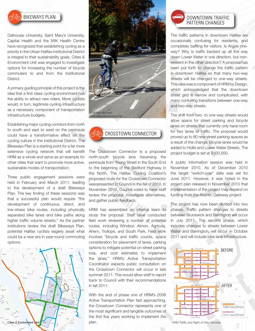
Dalhousie University, Saint Mary’s University, Capital Health and the IWK Health Centre have recognized that establishing cycling as a priority in the Urban Halifax Institutional District is integral to their sustainability goals. Cities & Environment Unit was engaged to investigate options for increasing the number of bicycle commuters to and from the Institutional District.
A primary guiding principle of this project is the idea that a first class cycling environment has the ability to attract new riders. More cyclists would, in turn, legitimize cycling infrastructure as a necessary component of transportation infrastructure budgets.
Establishing major cycling corridors from north to south and east to west on the peninsula could have a transformative effect on the cycling culture in the Institutional District. The Bikeways Plan is a starting point for a far more extensive cycling network that will benefit HRM as a whole and serve as an example for other cities that want to promote more active, sustainable modes of transportation.
Three public engagement sessions were held in February and March 2011, leading to the development of a draft Bikeways Plan. The key finding of these sessions was that a successful plan would require “the development of continuous, direct, and low-stress bike routes, including physically separated bike lanes and bike paths along higher traffic volume streets.” As the partner institutions review the draft Bikeways Plan, potential Halifax cyclists eagerly await what could be a new era in year-round commuting options.
The Crosstown Connector is a proposed north-south bicycle lane traversing the peninsula from Young Street in the South End to the beginning of the Bedford Highway in the North. The Halifax Cycling Coalition’s proposed route for the Crosstown Connector was presented to Council in the fall of 2010. In November 2010, Council voted to have staff review the proposal, investigate alternatives, and gather public feedback.
HRM has assembled an internal team to study the proposal. Staff have conducted field work reviewing a number of potential routes, including Windsor, Almon, Agricola, Ahern, Trollope, and South Park. Field work involves “bicycle and traffic counts, space consideration for placement of lanes, parking options to mitigate potential on-street parking loss, and cost estimates to implement the lanes.” HRM’s Active Transportation Coordinator expects public consultation on the Crosstown Connector will occur in late summer 2011. This would allow staff to report back to Council with their recommendations in fall 2011.
With the end of phase one of HRM’s 2006 Active Transportation Plan fast approaching, the Crosstown Connector represents one of the most significant and tangible outcomes of the first five years working to implement the plan.
The traffic patterns in downtown Halifax are occasionally confusing for residents, and completely baffling for visitors. Is Argyle one-way? Why is traffic backed up all the way down Lower Water in one direction, but non-existent in the other direction? A proposal has been put forth to change the traffic pattern in downtown Halifax so that many two-way streets will be changed to one-way streets. This idea was a component of HRM by Design, which acknowledged that the downtown street grid is narrow and complicated, with many confusing transitions between one-way and two-way streets.
The shift from two- to one-way streets would allow space for street parking and bicycle lanes on streets that currently only have room for two lanes of traffic. The proposal would proved up to 80 new street parking spaces as a result of the change. Bicycle lanes would be added to Hollis and Lower Water Streets. The project budget is set at $500,000.
A public information session was held in November 2010. As of December 2010 the target “switch-over” date was set for June 2011. However, it was noted in the project plan released in November 2010 that implementation of the project may depend on funding from the Atlantic Gateway project.
The project has now been divided into two phases. Traffic pattern changes to streets between Brunswick and Barrington will occur in July 2011. The second phase, which includes changes to streets between Lower Water and Barrington, will occur in October 2011 and will include bike lane infrastructure.
BEFORE
AFTER
Two-wayStreet
One-wayStreet
Barrington
Barrington
Brunswick
Brunswick
Lower Water
Lower Water
Hollis
Hollis
Spr
ing
Gar
den
Duk
e
Sac
kville
Sac
kville
Duk
e
Spr
ing
Gar
den
BIKEWAYS PLAN
CROSSTOWN CONNECTOR
DOWNTOWN TRAFFIC PATTERN CHANGES
METRO TRANSIT TERMINAL EXPANSIONS
WASHMILL LAKE COURT UNDERPASS DEVELOPMENT
BAYERS RD/HWY 102/HWY 107 TRANSPORTATION STUDY
EVENTS - JUNE/JULY 2011
HALI-FACTS
PLANNING & DESIGN CENTREUPDATE
BIKEWAYS PLAN
CROSSTOWN CONNECTOR
DOWNTOWN TRAFFIC PATTERN CHANGES
METRO TRANSIT TERMINAL EXPANSIONS
WASHMILL LAKE COURT UNDERPASS DEVELOPMENT
BAYERS RD/HWY 102/HWY 107 TRANSPORTATION STUDY
EVENTS - JUNE/JULY 2011
HALI-FACTS
PLANNING & DESIGN CENTREUPDATE
BIKEWAYS PLAN
CROSSTOWN CONNECTOR
DOWNTOWN TRAFFIC PATTERN CHANGES
METRO TRANSIT TERMINAL EXPANSIONS
WASHMILL LAKE COURT UNDERPASS DEVELOPMENT
BAYERS RD/HWY 102/HWY 107 TRANSPORTATION STUDY
EVENTS - JUNE/JULY 2011
HALI-FACTS
PLANNING & DESIGN CENTREUPDATE
HRM Traffic and Right-of-Way ServicesCities & Environment Unit
Matthew Blackettflickr.com/photos/spacing
Cities & Environment Unit
wa
shm
ill lake cr.
highw
ay 102
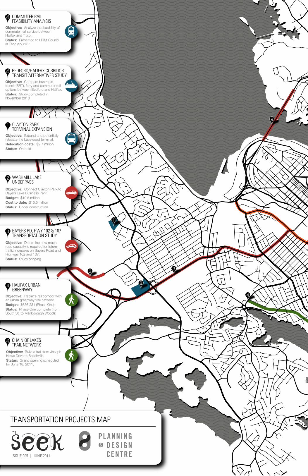
Public transit requires physical infrastructure like bus terminals to create hubs in the bus network, facilitate transfers, and provide users with a comfortable place to wait for a bus. The Dartmouth Bridge and Clayton Park bus terminals are over capacity, lacking amenities, and have been slated for redevelopment.
The Dartmouth Bridge Terminal has an approved design. Regional Council has voted for an option that includes a bridge connecting the terminal to the Dartmouth Common while screening noise and exhaust from buses. This option comes with a higher price tag, but addresses numerous concerns related to the terminal expansion raised by surrounding stakeholders. To compensate for the increased costs, HRM may have to postpone other capital projects. Currently, HRM is considering their options, including possibly delaying projects like a Metro X link to the Airport, a new ferry to augment Woodside Ferry service, and/or the Lacewood Drive Transit Terminal redevelopment.
A new terminal in Clayton Park on Lacewood Drive is getting close to choosing a site. Three HRM owned sites near the existing terminal on Lacewood Drive have been identified as candidates. An 8 acre site on Willet Street has emerged as the front-runner, with endorsements from a consultants report and, at least in principle, from Chebucto Community Council. The development process is underway. Planning amendments have been initiated, HRM staff are preparing a detailed site study, and a consultant has been contracted to conduct a technical noise and vibration report.
The Nova Scotia Department of Transportation and Infrastructure Renewal and the HRM have contracted Stantec Consulting to conduct a road and highway study concerning Bayers Road, Highway 102 and Highway 107.
The purpose of the study is to model traffic generation based on growth projections and determine how much road capacity is needed to handle that traffic. The study’s primary objective is to explore best uses of the Bayers Road / Highway 102 Corridor from Windsor Street in Halifax to Fall River. The study includes traffic projections and functional designs that could be implemented in stages over a 30-year period. Functional designs include road widening and existing road maintenance, as well as potential High Occupancy Vehicle (HOV) lanes and the creation of lanes dedicated to transit vehicles. The location of the proposed Highway 107 extension will connect Akerley Boulevard in Burnside near Dartmouth Crossing to Highway 102 near Duke Street.
Traffic planners say Bayers Road must be widened to accommodate projected growth in vehicle use over the next 30 years. However, the project has not been met without criticism from councilors and advocacy groups opposing road widening and fearing it will only bring about greater traffic congestion problems in the future.
The Corridor Study is complete, and will be presented to HRM’s Transportation Standing Committee this month.
The Washmill Lake Court Underpass will extend Washmill Lake Court, in the Bayers Lake Business Park, under Highway 102. The new connector will link up with Regency Park Drive east of the Highway. The underpass will provide a third entrance/exit to the Bayers Lake Business Park from the residential developments in Clayton Park.
This third access point was deemed necessary in order to allow for further development in the business park without increased traffic congestion. HRM identifies the underpass as a key deliverable in the Business Parks Development Functional Plan. The new connection also makes it possible to develop future housing on the east side of the highway adjacent to existing housing in Clayton Park
The cost of the three-phase project as approved in 2009 was $10 million, with two-thirds of the budget coming from federal infrastructure stimulus funding. Phases 1 and 2 exceeded the total budget by $1 million due to additional excavation and steel reinforcement costs. In April 2011, Regional Council approved a $4.5 million budget increase for the underpass so Phase 3 could proceed. This puts the total cost at $15.5 million, which is $5.5 million over the original budget for the project.
Washmill Lake Court Underpass completion was originally scheduled for the federal stimulus funding deadline of March 2011. HRM applied for and was granted an extension to this deadline, since the project was delayed by winter weather and the budget shortcoming. It is now anticipated that the underpass will be completed by the new federal stimulus deadline of October 2011.
BIKEWAYS PLAN
CROSSTOWN CONNECTOR
DOWNTOWN TRAFFIC PATTERN CHANGES
METRO TRANSIT TERMINAL EXPANSIONS
WASHMILL LAKE COURT UNDERPASS DEVELOPMENT
BAYERS RD/HWY 102/HWY 107 TRANSPORTATION STUDY
EVENTS - JUNE/JULY 2011
HALI-FACTS
PLANNING & DESIGN CENTREUPDATE
BIKEWAYS PLAN
CROSSTOWN CONNECTOR
DOWNTOWN TRAFFIC PATTERN CHANGES
METRO TRANSIT TERMINAL EXPANSIONS
WASHMILL LAKE COURT UNDERPASS DEVELOPMENT
BAYERS RD/HWY 102/HWY 107 TRANSPORTATION STUDY
EVENTS - JUNE/JULY 2011
HALI-FACTS
PLANNING & DESIGN CENTREUPDATE
BIKEWAYS PLAN
CROSSTOWN CONNECTOR
DOWNTOWN TRAFFIC PATTERN CHANGES
METRO TRANSIT TERMINAL EXPANSIONS
WASHMILL LAKE COURT UNDERPASS DEVELOPMENT
BAYERS RD/HWY 102/HWY 107 TRANSPORTATION STUDY
EVENTS - JUNE/JULY 2011
HALI-FACTS
PLANNING & DESIGN CENTREUPDATE
HRM Metro Transit
Stantec Inc.
CBC Mainstreet Nova Scotiacbc.ca/mainstreetns
HALIFAX CITADELNATIONAL HISTORIC
SITE
HALIFAXCOMMON
SIR SANFORDFLEMING PARK
DARTMOUTHCOMMON
PUBLICGARDENS
POINTPLEASANT
PARK
1
2
11
12
4
310
9
8
9
5
7
6
8HALIFAX URBAN GREENWAY
Objective: Replace rail corridor with an urban greenway trail network.Budget: $636,231 (Phase One)Status: Phase One complete (from South St. to Marlborough Woods)
Objective: Build a trail from Joseph Howe Drive to Beechville.Status: Grand opening scheduled for June 18, 2011.
4
WASHMILL LAKEUNDERPASS
Objective: Connect Clayton Park to Bayers Lake Business Park. Budget: $10.5 millionCost to date: $15.5 millionStatus: Under construction
2
BAYERS RD, HWY 102 & 107 TRANSPORTATION STUDY
Objective: Determine how much road capacity is required for future traffic increases on Bayers Road and Highway 102 and 107.Status: Study ongoing
3
CLAYTON PARK TERMINAL EXPANSION
Objective: Expand and potentially relocate the Lacewood terminal.Relocation costs: $2.7 millionStatus: On hold
1
COMMUTER RAIL FEASIBILITY ANALYSIS
Objective: Analyze the feasibility of commuter rail service between Halifax and Truro.Status: Presented to HRM Council in February 2011
CHAIN OF LAKESTRAIL NETWORK
offmap
CROSSTOWNCONNECTOR
Objective: Provide a north to south bicycle corridor with lanes and additional infrastructure.Status: Study ongoing
11
BIKEWAYSPLAN
Objective: Improve bike infrastruc-ture in the Institutional District.Estimated costs: $4-6 millionStatus: Study ongoing
12
DOWNTOWN TRAFFICCIRCULATION CHANGES
Objective: Improve traffic circulation in Downtown and add more parking and bike lanes.Status: Begins in July 2011
10
BRIDGE MAINTENANCE &TOLL INCREASES
Objective: Perform maintenance on MacKay Bridge and raise all bridge toll fees from 75¢ to $1.Status: Complete
9
METRO X ROUTE TO STANFIELD INT. AIRPORT
Objective: Establish a transit route to connect Halifax and Dartmouth to Stanfield International Airport.Estimated costs: $1.27 m (annually)Status: On hold
6
WOODSIDE FERRYSERVICE EXPANSION
Objective: Expand ferry service between Halifax and the Woodside terminal.Status: On hold
7
BRIDGE TERMINAL EXPANSION
Objective: Expand transit terminal to include more space and amenities for transit users.Budget: $12 millionStatus: Approved by Council
5
PENINSULA TRANSIT CORRIDOR STUDY
Objective: Optimize transit trips between park & ride lot at Hwy 102 / North West Arm Dr. and Scotia Square.Study costs: $160,000Status: Study ongoing
8
offmap
BEDFORD/HALIFAX CORRIDORTRANSIT ALTERNATIVES STUDY
Objective: Compare bus rapid transit (BRT), ferry and commuter rail options between Bedford and Halifax.Status: Study completed in November 2010
offmap
TRANSPORTATION PROJECTS MAP
ISSUE 005 | JUNE 2011250m 1km
Bike Again: Bike Repair Workshop Free bike repair instruction 5:30 – 9 pm, Mondays and Wednesdays; 6 – 8 pm, Tuesdays (women and transgendered night) Bloomfield Centre, 2786 Agricola
Bike Maintenance Clinics for Women Learn how to care for and fix your bike at the Halifax Cycle Gallery 6 – 8 pm, Wednesdays Halifax Cycle Gallery, 6299 Quinpool Rd
Bike Polo Bring your bike 12 pm Sundays and 7 pm Tuesdays Gorsebrook Park
Active Transportation Rally Cycle, jog or walk on Hammonds Plains Rd 1:30 pm, June 26 ghpca.ca Meet at Cornerstone Wesleyan Church and Tantallon Library parking lot
Canada Day July 1 hrmcanadaday.ca
Commons North Neighbourhood Clean-up Cleaning up local sidewalks, bus shelters, and other public spaces 9 am, last Saturday of every month Meet at Java Blend, 6027 North St
Critical Mass Bike Ride Take back the streets with a large group of cyclists 6 pm, last Friday of every month Meet at Victoria Park
Ecology Action Centre – Transportation Issues Committee Promoting sustainable transportation options for Nova Scotia 5:30 pm, first Monday of every month 2705 Fern Lane
Have ideas on how to make Halifax a better place? We are always looking for new volunteers to help with initiatives. Check out the events below and join the PDC’s Sustainable Transportation Task Force and our Switch working group.
The PDC will be hosting its Annual General Meeting on July 14th, 2011!
We have been working to collaborate with several key organizations in Halifax to organize events and new initiatives. Come out and learn more about us and hear about what we’ve been up to this past year!
Ralph Medjuck Architecture and Planning Building Auditorium. 5410 Spring Garden Road 5:30-7:00 pm
Join the PDC and Fusion for three upcoming public forums as part of It’s more than buses: Transit is about access, mobility, and a better city!
World Trade and Convention Centre
Explore: 6-8 pm, June 28th
Design: 6-8 pm, July 19th
Mobilize!: 6-8 pm, September 7th
Switch: Open Street Sundays is a proposed weekly event that encourages people to enjoy their city by walking, biking, skating, dancing, and moving around their city safely and comfortably. For more information, check us out at SWITCHHFX on twitter, or Facebook. The Switch working group meetings are held the first Wednesday of every month.