19
SEHORE DISTRICT MADHYA PRADESH Ministry of water Resources Central Ground Water Board North Central Region BHOPAL 2013
SEHORE DISTRICT MADHYA PRADESH
Ministry of water Resources
Central Ground Water Board
North Central Region
BHOPAL 2013

SEHORE DISTRICT AT A GLANCE
S.No. ITEMS STATISTICS
1. General Information i) Geographical area 6578 Km
2
ii) Administrative Divisions (As on 2012)
Number of Tehsil/Blocks
No of Villages
8/5
1. Sehore 2. Ashta,
3. Budni 4. Ichhawar,
5. Nasrullaganj and Nasrullaganj
1084
iii)Population (Census 2011) 1311008
iv)Average Annual Rainfall (mm) 1217.7 mm
2. Geomorphology
1. Major Physiographic Units
2. Major Drainage
- Narmada Basin Valley
- Chambal Basin Valley
- Betwa Basin
Ajnal, Newaj, Paru, Papnas,
Parva, Sewan, Utooli, Babbar,
Dobi, Kolar and Sip
3. Land Use (Km2)
i) Forest area: 1725.39
ii) Net area sown: 6289
iii) Cultivable area: 3968.7
4. Major Soil Types Black Cotton
5. Area Under Principal Crops
6. Irrigation By Different Sources Nos. Irrigated area km2
Dugwells 33647 834
Tube wells/Bore wells 20877 539
Tanks/Ponds 64 63
Canals 94 412
Other Sources 947
Gross Irrigated Area 2297
7. Number of Ground Water Monitoring Wells of CGWB(As on 31.3.2012)
No. of Dug Wells
No. of Piezometers
14
12
8 Predominant Geological Formations Deccan Trap basalts
underlained by Vindhyan
sandstone and alluvium
9 Hydrogeology
Major Water Bearing Formation
(Pre-monsoon depth to water level during
12)
(Post-monsoon depth to water level during
06)
Long Term water level trend in 10 years
(2003-2012) in m/yr
Weathered/vesicular basalt,
flow contacts, fractured
sandstone and granular sand
4.30 – 16.86 m/annum fall
4.01-11.95 m/annum rise
Pre-monsoon
0.1-5.22 m/annum fall
Post-monsoon
0.01-2.18 m/annum rise

10. Ground Water Exploration By CGWB (As on 31.3.2013)
No of wells drilled (EW,OW,PZ,SH, Total) 37 EW, 10 OW, 13 PZ
Depth Range (m) 48.0 – 290.41 mbgl
Discharge (litres per second) 0.7 – 12.18
Storativity (S)
Transmissivity (m2
/day) 0.94 m2
/day
11. Ground Water Quality
Presence of Chemical constituents more
than permissible limit (eg EC, F, As,Fe)
Nitrate
Type of Water Alkaline
12 Dynamic Ground Water Resources (2011) In MCM
Net Ground Water available 771.72
Gross Annual Ground Water Draft 573.94
Projected Demand for Domestic and
Industrial uses up to 2035
32.37
Stage of Ground Water Development 74%
13 Awareness and Training Activity
Mass Awareness Programmes Organised
Date:
Place:
No. of Participant:
Nil
Water Management Training Programmes
Date:13-12-2001
Place: Jawaher Lal Nehru Agriculture
Coolege
No. of Participant: 55
One
14 Efforts of Artificial Recharge & Rainwater Harvesting
Projects completed by CGWB (No. &
Amount Spent)
Nil
Projects under technical guidance of
CGWB (Numbers)
Dugwell recharge
15 Ground Water Control and Regulation
Number of OE Blocks Nil
Number of Sem Critical Blocks 2
Number of Notified Blocks Nil
16 Major Groundwater Problems and
Issues
Depletion in groundwater level
and deterioration of
Groundwater quality

1.0 INTRODUCTION
Sehore district is lying in the central part of Madhya Pradesh. It is in
Bhopal commissioner’s division and is well connected by roads and railway.
National Highway 67, connecting Bhopal and Dewas passes through the district.
There are 5 tehsils and 5 blocks in the district. The block headquarters are Ashta,
Sehore, Ichhawar, Budhni and Nasrullaganj. Sehore district with an area of 6579 km2
lying between the North Latitudes 220 33’ 30” and 23
0 40’ 25” and East Longitudes
780 26’ 00” and 78
0 02’ 00” and falls under the Survey of India toposheet No. 55A,
55B, 55F and 55F. The district is encircled by Guna district in the North, Vidisha and
Raisen in the east, Hoshangabad and Dewas in the South and Shajapur and Rajgarh in
the west (figure 1).
Ahmadpur
S hampur
SEHORE
Astha
Pa
rba
ti R
New
al R
JawarChhawar
Nidan
Nasurullahganj
Malibyan
Narmada R
Budhni
S
H
A
J
A
P
U
R
NA
RSI
NG
HG
AR
H
B H
O P
A L
R A I S E N
H O
S
H
A
N
G
A
B
A
D
A S
D E W
Fig. - 1 INDEX MAP, DISTRICT SEHORE (M.P.)
Bhikheri
Jalta Kheda
Amlaha
Bilaisqan
Larkur
RalaNeel
Bhaya
LEGEND
Distr ict Boundary
Block Boundary
Block Head Quarter
Hydrograph Station
Road
River
S ip Nalla
Kolar N
Ajn
al N
Kachhar
Kola
r N
Km. 5 0 5 10 15 20 25 Km.
SCALE
Parb
ati R
Administrative Division
The district is sub divided into five administrative blocks and five
tehsils. The administrative divisions are shown in figure-1 and details are given in
table–1.
Table – 1: Administrative Division, District Sehore, M.P.
District/ Block Area Sq.km

District Sehore 6578
1. Sehore 1584.25
2. Ashta 1454.57
3. Ichhawar 1110.85
4. Budhni 1075.11
5. Nasrullaganj 1353.22
Sehore district forms the part of Malwa plateau with an undulating
topography. Sehore district is primarily an agricultural district occupying the
Chambal and Narmada basin valley, having predominantly an agricultural economy.
Agriculture is the main occupation of the people in the district. Wheat, Rice, Jawar,
Maize and Soyabean are the major crops sown in the district. Ground water has an
important role to play for irrigation.
Out of total 1810.23 hectares irrigated land, 1128.48 hectares was irrigated
from ground water sources. There were 14698 tube wells and 33048 dug wells up to
the year 2006 for irrigation purpose.
The statistical data of land use and Irrigation pattern of Sehore district has
been extracted from the district statistical booklet, Sehore district 2006. The land use
for the district is given in Table – 2. The irrigation details for the district are given in
table – 3.
Land Use (Km2)
i) Forest area 333.7
ii) Net area sown 5619
iii) Cultivable area 4445.36
Irrigation By Different Sources
Type No Irrigated Area
(Ha)
Dugwells 11433 282
Tube wells/Bore wells 15490 811
Tanks/Ponds 129 20
Canals 15 642
Other Sources 146
Net Irrigated Area 2101
Gross Irrigated Area) 2101
2.0 RAINFALL AND CLIMATE
Climatology
The Climate of Sehore district can be divided into four seasons. The winter
season commences from end of November and lasts till the end of Feb. The period
from March to about the middle of June is the hot season. The south west monsoon
season from middle of June to end of September, October & end of November
constitute the post monsoon or retreating monsoon season.
Rainfall
There are five rain gauge stations in Sehore district namely Astha, Ichhawar,
Nasrullaganj, Budhni and Sehore itself. The normal rainfall of Sehore district is
1217.7 mm. The highest rainfall i.e. 1412.3mm received at Sehore and minimum at
Astha i.e. 1054.9 mm. July is the wettest month of the year and about 36% of the
annual rainfall takes place during this month only. About 92.4% of the annual rainfall
takes place during the southwest monsoon period i.e. between June to September.
About 6.2% and 1.4% rainfall received during winter and summer season respectively.
Hence only 7.6% of the annual rainfall takes place from October to May months.
`
Temperature
There is no meteorological observatory at Sehore district. The nearest
meterological observatory is at Bairagarh where similar conditions prevail. The
winter season starts from end of November & ends till last week of February. The
January is the coldest month of the year. The average normal minimum temperature
during the month is about 10.4%. The individual day temperature comes as low as 1
or 20C. From March onwards, the temperature starts rising and maximum temperature
observed during the month of May.
The average normal maximum temperature is 40.70C. The individual day
temperature as high as 45 or 460C. On the arrival of monsoon the weather became
pleasant. In October, the retreating of monsoon the temperature rises slightly during
the day time and nights become pleasant. The average annual normal temperature of
Sehore district is 31.40C.
During the southwest monsoon the relative humidity are generally high
exceeding about 88% in August. Humidity decreases in the post monsoon season. In
the cold season it is fairly good over the district. The driest part of the year is the
summer season with the humidity going down to 26% or less. The annual normal
relative humidity of the district is 57%.
Winds are generally light to moderate in the district with some slight
strengthening in force during the monsoon season. The wind velocity in the post
monsoon or during the winter season is, in general, low as compared to Premonsoon
or summer season. The normal average and wind velocity of the district is about 8.3
Km/hr.
CGWB ACTIVITE Shri G.M. Reddy, Hydro geologist, carried out systematic Hydrogeological
Surveys in part of the district during 1986-87, Shri M.L. Parmar, Hydro geologist and
Shri S. Brahma Hydro geologist, CGWB, NCR in 1990-91. S/Shri S.C. Paranjpe and
A. Srinivas carried out reappraisal Hydrogeological surveys during AAP 1994-1995
in the district.
Under the World Bank assisted Hydrology Project- I, 13 shallow and deep
piezometers have been drilled by the Central Ground Water for water level and
quality monitoring.
In Sehore district, 23 boreholes were drilled under Accelerated drilling
programme in basaltic formation 7 boreholes were drilled up to the depth of 200 mbgl
and remaining B/wells drilled up to the depths ranges from 101.14 (Jatakhera) to
196.85 mbgl (Bhankheri). The maximum numbers of exploratory borholes have been
logged by natural gamma logging. Static water level of boreholes ranges from 1.63
mbgl. (Amajher) to 80 mbgl (Mahodia) and yield potential of boreholes varies from
0.70 lps (Jalki) to 12.18 lps (Hakimabad and Maina) Pachama and Khanelwa).
In Sehore district groundwater management-training programme have been
organized by CGWB at Jawaher Lal Nehru Agriculuture College, Sehore.
3.0 GEOMORPHOLOGY & SOIL TYPES
Physiographically the district has been divided into three units based on
the valleys formed by the major rivers i.e. Narmada basin, Chambal basin and Betwa
basin.
Narmada Basin Valley
In the district the Narmada basin valley comprises an area of about 3295 Km2.
The surface water divide running between Ichhawar and Bilkishganj roughly marks
the northern boundary of the basin. The northern boundary is marked by low-lying
hills and or high grounds. The basin area is highly undulating with isolated hills and
plains. The ground elevation ranges between 300 m and 667 m. above m.s.l. The
ground slopes from north to south and east to west.
Chambal Basin Valley
The Chambal basin valley constituents an area of about 3108 Km2
falling in the entire Ashta block and the area north of Ichhawar in the district. The
hilly area high grounds occupying the eastern boundary of the district forms the
surface water divide. The area along the western boundary of district, along which
Parbati river flows, forms a valley. The southern boundary is also bounded by semi
hilly area, high ground that forms the surface water divide. The interior area of the
basin is undulating with isolated hills and elevated plains. The ground elevation in the
basin vary between a minimum elevation in the basin vary between a minimum of
about 455 m in the North/North west to about 545m above m.s.l. in the
South/Southwest. The land in the basin slopes from south to north in Ashta area, and
from north to west in the remaining area.
Betwa Basin
A small part of the district, measuring about 175 Km2 is located in the
east central part of the district forming the Betwa river basin, drained by its tributary
the Kolinos nadi. The presence of elevated ground on all the three sides of the basin
marks the surface water divide. The interior area of the basin is marked by undulating
topography with elevated plains with very few low altitude isolated hills. The ground

elevations in the area vary between about 545/550 m in the south and west and about
520 in the east. The hydrological features of district are given in table 4.
Table- 4 : Hydrological Features
Basin Name of the river Catchments
area in Km2
Total length
in km
Total yield at
75%
dependability
CHAMBAL
Ajnal 410.00 30.0 142.56
Newaj 410.00 28.0 68.47
Paru 392.00 46.0 136.30
Papnas 250.00 35.0 71.27
Parva 205.00 32.0 86.98
Sewan 164.00 26.0 57.02
Utooli 174.00 34.0 60.50
Independent 1270.00 N.A. 444.01
Total 3285.00 - 1067.11
NARMADA
Babbar 287.0 38.0 124.84
Dobi 152.0 25.0 66.12
Kolar 960.0 103.0 417.60
Sip 796.0 72.0 320.16
Independent 908.0 - 394.38
Total 3103.0 - 1323.70
BETWA
Independent - 41.64
Catchment 175.7
Grand Total 6563.7 - 2432.45
The district is generally covered with black cotton soils covering almost three fourths
of the area. This part is occupied by Deccan Basalts. The rest part has red-yellow
mixed soils derived from sandstone, shale, gneiss. The alluvial soils are found along
the river courses. The higher elevations i.e. the hilly regions have a cover of murum,
which is made up of small rounded pieces of weathered trap. The Vindhyans and
Bijawars have a thin cover of sandy loams. The soils in granitic area are clayey. The
schist has a thin capping of loam with lot of quartz grains. The alluvium is derived
from hill slopes by numerous streams and watercourses.
4.0 GROUND WATER SCENARIO
Over 85% of the area is occupied by Deccan trap, about 10% by alluvium and
about 5% of the area by Vindhyan formations. The generalized geological succession
is given below in table 5 and the hydrogeological map of district is shown in figure 2.
Table-5: General geological succession of Sehore district.
Age Formation Lithology
Quaternary Alluvium Clay, Sand, Silt, Gravel
Laterite Soil
Lower Eocene
To
Deccan Trap Lava flows of basalt
Upper Cretaceous
Pre-Cambrian Vindhyans Quartzitic sandstone with
intercalated shales.
Vindhyan Formations
Upper Vindhyan formations comprising of sandstone shales and breccias are
exposed in the northern and eastern part of the district. The small patch of the area
falling in the northern part is exposed in the form of hills. It occupies an area of about
50 Sq.km and comprises of sandstones. A major part of Budhni block, except east
and western parts, is occupied by Vindhyan formation and comprises of sandstone
and shales. The sandstones are normally hard, Quartzitic, massive and compact.
However, they are jointed at the surface level.
Deccan trap formations
Deccan trap formations occupy over 85% of the total area of the district. The
general flow is characteristic of lava flows in the area are the most of the flows are of
‘Aa’ type in nature being disposed in a three-fold system along a vertical column.
Each flow normally consists of an upper fragmentary zone, a middle massive part and
an impersistent thin layer of basalt clinkers. The fragmentary top zone presents a
brecciated look. It is very often highly vesicular and amygdular. The vesicles are
generally sub- rounded to irregular in shape. The middle part comprises of massive
basalt, which is aphanitic to highly porphyritic.
Basalt clinker & horizon is impersistent and often absent. The thickness of
this horizon where ever present varies between a few centimeters to about 0.50 m.
This zone is analogous to top vesicular amygdular horizons in physical characters.
Variation in thickness of different flows is also evident in the area. Most of the flow
contacts can be demarcated by the presence of a red bole horizon. About 12 flows of
Deccan trap can be identified in the district between the altitudes 435 and 533 m
above msl. In general the thickness of the individual flows range between 5 and 10m.
However, the older flows seems to have more thickness compared to the younger ones
as indicated by flow numbers, 0 and 1.
Alluvium
Recent to sub-recent alluvial formations of significant extension occur in the
southeastern part of the district falling in Budhni block. The alluvial formation in this
part occurs along the Narmada River. The other patches of alluvial formation, though
insignificant in both aerial extension and thickness occur along the major rivers and
streams flowing in the area. The alluvial formations comprises of Silt, Clay, Sand,
Gravel and Pebbles Cobbles etc. with Kankar. The district is covered mostly with
Deccan trap formation deposited over the rocks of Vindhyan system. The alluvial area
in the district occurs mainly along Narmada and Parbati rivers.
Description of rocks and their water bearing properties
Vindhyan System
A major portion of Budhni block falling in the southeastern part of the district
is covered with Vindhyan formations comprising sandstones, shales, quartzite and
breccia. The Vindhyans are, in general, poor aquifers, however, these formations

when subjected to weathering or jointing and fracturing gives rise to moderately
yielding aquifers. The depth to water level in this formation varies from 4.86 m to
9.50 m.bgl. and season water level fluctuation ranges from 0.85 to 3.00 metres. The
yield of wells in this formation varies from 1 to 3 lps.
Deccan trap formations
The Deccan trap formation occupies about 85% of the total area of the district.
The main aquifer systems in the formation are the weathered, vesicular flow contacts
jointed, fractured zones etc. The ground water occurs mainly under phreatic
conditions the red bole horizon generally confined conditions the red bole horizon
generally act as semi-confining and confining layers in the deep aquifers. The yield of
wells in this formation varies from 1 to 5 lps.
Alluvium
Alluvial area in the district occurs mainly along Narmada and Parbati River. A
major pertain of alluvial patch occurs along Narmada river falling in Budhni block
small linear patches of alluvium also occur along Parbati river in the western side of
the district. The alluvium consists of clay, silt, sand, gravels and pebbles. The sandy
gravelling zones when saturated form very good aquifers. The yield of the formation
depends upon the ranges from 5 to 10 lps.
1400
13
00
440
12
00
11
00
Parb
ati R
New
al R
480
500
520
520
500
480
300
290
1400
13001
200
2901100
300
480
520
AsthaIchhawar
Nasurullahganj
Budhni
SEHORE
NARM ADA R
H
O
S
H
A
N
G
A
B
A D
S
H
A
J
A
P
U
R
B H
O P
A L
R A I S E N
D E W
A S
NA
RSI
NG
HG
AR
H
Fig. - 2 HYDROGEOLOGY, DISTRICT SEHORE (M.P.)
Km. 5 0 5 10 15 20 25 Km.
LEGEND
LITHOLOGY YIELD POTENTIAL
Alluvium
Deccan Trap
Vindhyans
Water Table Contour
Flow Direction
CGWB Monitoring Well
Isohyets
5 - 10 lps
1 - 5 lps
1 - 3 lps
300
1100
SCALE
WATER LEVELS
A scientific database of groundwater levels is essential for assessing the
regional groundwater scenario to reliably estimate the groundwater resources for long
term planning and judicious use of available groundwater resources. Variation in
groundwater levels in an area is an important component of the hydrological cycle
because it is a physical reflection of aquifer systems. As change in groundwater level
is directly related to groundwater balance its continuous records provide direct
information to geo-environmental changes due to withdrawal of groundwater. To
monitor the seasonal and year by year change in quantity and quality of groundwater,
Central Ground Water Board (CGWB) has established 20National Hydrograph
Stations (NHS) and 6 Peizometers in Sehore district. It is felt that due to large-scale
ground water development in the district the phreatic aquifers are overexploited and
resulting erratic water level record from monitoring dug well.
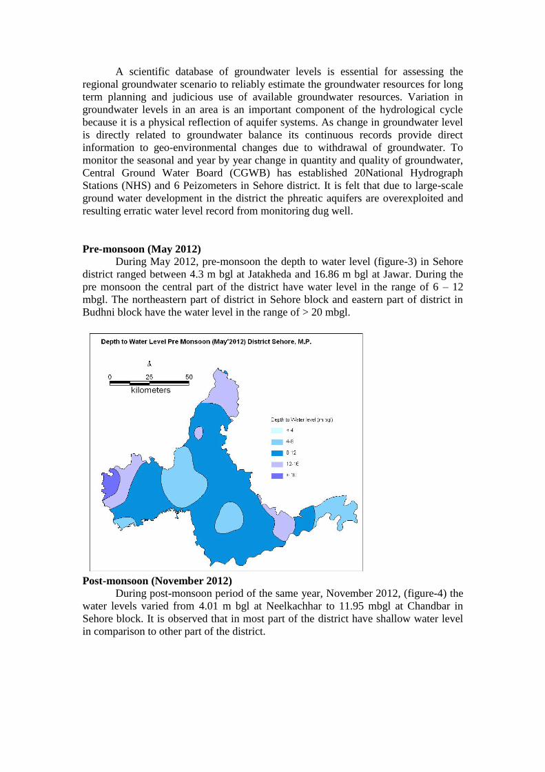
Pre-monsoon (May 2012)
During May 2012, pre-monsoon the depth to water level (figure-3) in Sehore
district ranged between 4.3 m bgl at Jatakheda and 16.86 m bgl at Jawar. During the
pre monsoon the central part of the district have water level in the range of 6 – 12
mbgl. The northeastern part of district in Sehore block and eastern part of district in
Budhni block have the water level in the range of > 20 mbgl.
Post-monsoon (November 2012)
During post-monsoon period of the same year, November 2012, (figure-4) the
water levels varied from 4.01 m bgl at Neelkachhar to 11.95 mbgl at Chandbar in
Sehore block. It is observed that in most part of the district have shallow water level
in comparison to other part of the district.

Decadal Average Water Level (May 2003-2012)
Decadal average water level is an average of water levels of a particular
monitoring station for the last 10 consecutive years. This gives a more realistic picture
of the area as the water level of any particular year depends on rainfall and draft and
may vary widely during the particular year. It is observed that there is a fall of 0.1-
5.22 m/annum during premonsoon and rise of 0.01-2.18 m/annum during post
monsoon.
Aquifer Parameters
The exploratory drilling has been carried out mainly in areas occupied by
Deccan Traps underlain by Vindhyan shale and sandstone. In Basalt, the vesicular,
weathered and fractured basalt form the aquifers while in Vindhyan, fractured
sandstones are aquifer. These exploratory wells were mostly drilled down to a depth
of 290.41 m bgl, yielding upto 15 lps discharge. The piezometers were restricted to
the depth of. 30 m, 60 m, 90 m and 120 m bgl. The specific capacity, as determined in
a few wells in basalt area, ranged from 3.5 to 61.23 lpm/m of draw down while in
alluvium areas it varies from 15 to 120 lpm/m. The transmissivity of basaltic aquifer
varies between 0.94 m2/day to 28.9 m
2/day while in alluvium formation it varies
between 32.31 to 137.87 m2/day.
4.2 Ground Water Resources
The entire command area in all blocks of district are in safe categories while
the non-command area of Sehore and Ashta blocks fall under critical category. The

stage of ground water development has reached to 98% and 89 % in Sehore and
Astha block respectively of district.
The Net annual ground water available in the Sehore District is 749.99 MCM
and draft from all uses is 576.99 MCM, Net ground water available for future
irrigation use is 141.06 MCM. The Net annual ground water available in the Sehore
District and draft from all uses for all the blocks is given in table.
Table: Ground Water Resources & Stage of Development in Sehore District.
S. No. District/
Assessment
Unit
Sub-unit
Command/
Non-
Command/
Net Annual
Ground
water
Availability
(ham)
Existing
Gross
Ground
water
Draft for
Irrigation
(ham)
Existing
Gross
Ground
water
Draft for
Domestic
&
Industrial
water
Supply
(ham)
Existing
Gross
Ground
water
Draft
for All
uses
(11+12)
(ham)
Provision
for
domestic,
and
industrial
requirement
supply to
next 25 year
(2033)
(ham)
Net Ground
water
Availability
for future
irrigation d
development
(ham)
Stage of
Ground
water
Development
{(13/10)*100}
(%)
Sehore
Ashta Command
Non-Command 21648 18602 661 19263 836 2209 89
Block Total 21648 18602 661 19263 836 2209 89
Budhni Command 3677 687 217 904 230 2760 25
Non-Command 6399 3469 247 3716 913 2017 58
Block Total 10077 4157 464 4621 1143 4777 46
Ichawar Command
Non-Command 7530 4248 305 4553 407 2876 60
Block Total 7530 4248 305 4553 407 2876 60
Nasrulla Ganj Command 3442 363 98 461 106 2973 13
Non-Command 9329 4192 349 4542 498 4638 49
Block Total 12770 4556 448 5003 604 7611 39
Sehore Command
Non-Command 25147 23709 246 23955 246 1192 95
Block Total 25147 23709 246 23955 246 1192 95
District Total 77172 55271 2124 57394 3237 18664 74
4.3 Ground Water Quality
Ground water quality to be contiguous to Sehore district is assessed annually
by CGWB on the basis of analysis of ground water samples collected from 8 No.
of hydrograph stations in the district. On the basis of the data for the year 2011, the
water quality is described as follows:
Quality of Ground Water for Drinking Purpose: The pH values of all the
water samples varied in between 7.20 to 7.80 hence proved alkaline in nature and
were within permissible limit (6.50 to 8.50) as described by BIS (IS: 10500: 2009).
The EC values were found to be in the range of 786 and 1762 μS/cm at 25 0C
(Larkui, highest) with an average of 1098 μS/cm at 25 0C and were underneath of
permissible limit (3000 μS/cm at 25 0C) as described by BIS (IS: 10500: 2009).
The anion chemistry shows that the chloride concentration ranged 35 - 305 mg/l in
the area surveilled and two locations namely Larkui (305 mg/l, highest) and Astha
(252 mg/l) reported to have chloride concentration more than desirable safe limit
of 250 mg/l as set by BIS (IS: 10500:2009). The concentration of NO3–
exceeding
45 mg/l (BIS, IS: 10500: 2009) were reported in 50% wells with highest as 97

mg/l of Bhaya. This higher concentration of NO3–
can be attributed from
anthropological sources. A scrutiny of data shows that none well of the district was
reported having fluoride greater than 1.5 mg/l of BIS (IS: 10500: 2009) permissible
limit
Quality of Ground Water for Irrigation: The chemical quality of water is an
important factor to be considered in evaluating its suitability for irrigation purpose.
The parameters such as Electrical conductance (EC), Sodium adsorption ratio
(SAR), percent sodium (% Na), and Residual sodium carbonate (RSC) are used to
classify the water quality for irrigation purpose. A diagram for classifying waters
for irrigation purpose was suggested by the U.S. Salinity Laboratory in 1954. The
plot of U.S. Salinity Laboratory diagram suggested that all the studied 100 % wells
of district shorted under C3-S1 (High Salinity & Low Sodium) class. This water can
be used for irrigation purpose applying restriction on drainage.
4.4 Status of Ground Water Development
Ground water is the main source for drinking and irrigation in the Sehore
district. About 74% of irrigation in the district is from ground water, though the level
of irrigation in the district is very low, only 27.5% of total geographical area is being
irrigated. The total number of dug wells and tube wells in the district were 33647 and
20877 respectively. On the drinking water front, Sehore city have entire supply from
ground water, while the outskirts of Sehore city is totally dependent on groundwater.
There has been a steady rise in ground water development in the district. The Stage of
Development in the district during 2011 was 77%, which has increased considerably
from 1997 estimates.
5.0 GROUND WATER MANAGEMENT STRATEGY
It is felt that the overexploitation, indiscriminate development of groundwater,
anthropogenic and irrigation practices have led to many groundwater related
problems, which need proper management of groundwater resources. These problems
are being discussed below.
5.1 Groundwater Depletion:
It is observed that in Sehore district, the stage of groundwater development is
quite high (95%). In certain areas the withdrawal of groundwater is more than
recharges causing depletion in groundwater level. It is observed that the fluctuation in
water table is mainly due to rainfall and withdrawal of groundwater. The study on the
long term analysis of water level, conducted by CGWB, indicate that water level in
Sehore district have shown a steady decline of 0 to 2.49 m during past one decade.
The incidence of rainfall remaining more or less same in the period of question the
only possible reason for the decline in groundwater level appears to be over
development of groundwater resources indiscriminately through ever increasing
number of tube wells tapping the unconfined and unconfined aquifers for agricultural,
industrial and domestic uses. To remedy the ill effects, the following steps are
required to be taken for effective groundwater management in Sehore district.
5.1.1 Groundwater recharge:

Due to fast industrialization and urbanization in Sehore district, there is a
reduction in open green areas resulted in substantial decrease in natural recharge to
groundwater. Also, the improvement in drainage pattern has caused reduction in
percolation of rainwater to the groundwater thereby affecting the natural recharge. It
is reported that huge amount of surface water available during rainy season goes as
runoff. Hence it can be harnessed through suitable artificial recharge techniques to
groundwater. Construction of various suitable artificial groundwater recharge
structures will result in augmentation of the groundwater aquifers and arrest further
decline of groundwater level. As the area is urban area the roof top rainwater
harvesting technique should be adopted in a big way. As the geology of the area along
with climatological and pedalogical parameters provide the hydrogeological
environment which governs the groundwater recharge, modern techniques like remote
sensing and geophysics should be applied for finalization of location, extent and
design of artificial groundwater recharge structures.
5.1.2 Water conservation:
It is evident that to solve the problem of depletion in groundwater level, it is
necessary that the groundwater withdrawal should be reduced substantially. Some of
the options available are:
5.1.2.1 Recycling of water:
Due to limited groundwater resources and increased demand of water there is
a need of recycling of water for its conservation. The treated sewage water can
judiciously be utilized to reduce stress on exploitation of groundwater for various
purposes including domestic, industrial and horticultural needs.
5.1.2.2 Change in cropping pattern:
In last few decades the cropping pattern in Sehore district has changed
substantially. In some parts of district, the farmers have started multi crop cultivation
due to profitability which will caused extensive development of groundwater
resources. There is a need to change the cropping pattern in the area and adopt
cultivation of those crops, which require less irrigation.
5.1.2.3Change in irrigation policy and power pricing:
It is observed that in many parts of Sehore district the complete irrigation is
being done through flooding. As the district is covered with hard rock terrain and is
water scare, the flooding practice of irrigation requires change. Sprinkler and drip
irrigation should be adopted in the area wherever feasible. In this regards the
government should come forward and provide infrastructure and other benefits. In
most parts of district the irrigation is being done through dugwell and tubewells using
power pump. Rates of power for tube well irrigation are irrational and require
modification. There should be no free power for irrigation so the consumers should
take due cares for its economic and judicious use. Instead of flat rates, metering may
be introduced.
5.1.2.4 Mass awareness program:

The management of groundwater resources cannot be successful without
public participation. It requires educating the public regarding judicious use of water.
To make the public aware, it is necessary to educate the people through mass
awareness program at grass root level and impart training on rainwater harvesting and
artificial recharge techniques for groundwater augmentation.
5.1.2.5 Groundwater regulation:
As the groundwater condition in Sehore district is in alarming stage,
groundwater regulation may be enforced for its judicious exploitation and use.
5.2 Groundwater Pollution:
Due to increasing industrialization and fast population growth in Sehore
district, anthropogenic activities have led to pollution of groundwater in certain areas.
The main sources of pollution are domestic and municipal waste, agricultural
practices and industrial activities. Most of the localities/villages in Sehore district do
not have proper sewage treatment system; the groundwater gets polluted with variety
of nutritional constituents and pathogenic microbes.
Use of various chemical fertilizers and pesticides has led to increase of
nitrates, phosphates and other organic component in groundwater. Untreated effluents
discharged in/on ground have caused increased level of heavy metals. Some organic
compounds have also led to deterioration of quality of groundwater.
5.2.1 Action Plan:
It is fact that the groundwater pollution in the area increasing day by day there
is a need to take up the comprehensive groundwater pollution studies in the Sehore
district township. It is necessary to initiate measures to control further groundwater
pollution. Dilution of pollutant concentration through groundwater recharge can be
effective to mitigate the hazards of high concentration of chemical constituents. It is
also desirable to formulate water supply schemes utilizing such water for purpose
other than drinking.
6.0 RECOMMENDATIONS
I. Sehore district is presenting a sensible picture from ground water point of
view. Though, presently ground water is meeting the most water needs of the
district but it may not go very long in future. The average water levels of the
district are deep, the decadal fluctuations and the long-term trends are showing
a decline, and the water balance left is limited. The population and progress
coupled with poor aquifers are responsible for this alarming situation. Thus
special caution is to be observed while developing this natural resource.
II. The groundwater development in Sehore district, both for irrigation and
domestic purposes, is being done on need basis without proper backup of
scientific investigations. Some times failure of monsoon led to crisis of even

drinking water in district. A serious thought should be given to plan future
development of groundwater on scientific lines. For a planned and coordinated
development of groundwater resources it is essential that detailed
hydrogeological, remote sensing and geophysical investigation should be
carried out before taking decision on finalization of sites for drilling wells for
irrigation and domestic use. The lithological details along with aquifer wise
yield records should be maintained for future inferences.
III. The groundwater resource evaluation for year 2011 indicates that the stage of
groundwater development in district has reached to 77%. The Net annual
ground water available in the Sehore District is 749.99 MCM and draft from
all uses is 576.99 MCM, Net ground water available for future irrigation use is
141.06 MCM only. Thus it has become imperative for further detailed
hydrogeological investigation in district for water balance studies making
watershed as a unit.
IV. Sehore district is mainly a hard rock area and the decision for the type of
groundwater structures for groundwater development is dictated by local
hydrogeological situation. Figure-5 shows the areas recommended for future
groundwater development in Sehore district.
a. In areas of phreatic aquifers with low permeability large diameter
dugwells is the only suitable groundwater structure. The dugwell
should be located as for as possible in topographic depressions, nearer
to rivers and streams and if possible nearer to zone of structural
disturbances. In Deccan trap areas of the district, instead of increasing
the diameter of dugwells drilling of horizontal bore into the dugwell
should be preferred to increase the yield of dugwell.
b. In certain areas of district where dugwell do not penetrate fully to the
aquifer, it is recommended that dug cum bore wells may be
constructed.
c. As the intertrapens are present between two flows and are collapsible
in nature, telescopic drilling should be adopted for screening/casing the
collapsible strata to increase the longevity and yield of boreholes.
d. In view of the limited regional extent of joints/fracturing, it is possible
to miss a good water bearing horizons in a small diameter borehole
during the drilling. It is recommended that technique of hydro-
fracturing/bore blasting should be tried to enhance the yield of
boreholes.
e. For wells constructed for drinking water it is much more important to
ensure that the intake section of tubewell is not directly in connection
with pollution from ground surface.
V. It is observed that in most part of the district there is an ample fluctuation in
depth to water level during pre and post monsoon period. Also, there is
substantial surplus monsoon run off going as unutilized needs to be conserved
through artificial recharge techniques. In order to get sustainable yield from

groundwater structures the need for augmentation of groundwater resources
through artificial recharge structure is imperative. Artificial Recharge
practices in rural areas should be taken up earnestly to improve the ground
water quantity and quality. The selection of sites should be done on scientific
basis by conducting hydrogeological and geophysical investigations.
VI. The Roof Top Rainwater Harvesting technique has wide scope in the areas
covered with weathered basalt. In Vindhyan rock formation, tubewells can be
used for this purpose. Roof top rainwater harvesting should be made
mandatory considering the water scarcity in urban areas. This would mitigate
the situation.
VII. Unscientific use of fertilizer/pesticides for agriculture and disposal of
untreated industrial effluents through unlined drain in most of the industrial
areas of district will be very dangerous for groundwater quality in near future.
There is a urgent need to control such type of activities to check the
groundwater pollution.
VIII. The deforestation of forestland to accommodate the population growth causes
heavy run off and insufficient subsurface recharge to groundwater storage in
foothill zone. Afforestation programme in such areas need to be taken up. This
would not only check soil erosion and improve the environment but also
conserve surface runoff and recharge the phreatic aquifers in the area.
Ahmadpur
S hampur
Astha
Pa
rba
ti R
New
al R
Jawar Ichhawar
Nasurullahganj
Malibyan
Narmada R
Budhni
S
H
A
J
A
P
U
R
NA
RSI
NG
HG
AR
H
B H
O P
A L
R A I S E N
H O
S
H
A
N
G
A
B
A
D
A S
D E W
Fig. - 3 RECOMENDATION, DISTRICT SEHORE (M.P.)
LEGEND
Area Recomended for further Development
S ip Nalla
Kolar N
Ajn
al N
Kola
r N
Km. 5 0 5 10 15 20 25 Km.
SCALE
Pa
rba
ti R
SEHORE

IX. Change in cropping pattern is another measure, which will relieve the
situation. Presently Soya bean crop is being grown in large areas, which has a
high water requirement. There is a need to change the cropping pattern in the
area and adopt cultivation of those crops, which require less irrigation.
Compiled By
Dr Subhash C Singh
Sr Geophysicist
Under the able guidance of
Parvinder Singh
HOO
Central Ground Water Board
North Central Region
Bhopal, M.P.


![[XLS] · Web viewJyoti Nagar Piprali Road Gurukripa Circle Sikar 01572 DIA-1678 Sisodia New Surya Hospital Ganga Ashram Sehore DIA-1679 Noor Institute of Medical Specialities (P)](https://static.documents.pub/doc/80x56/5b040a1e7f8b9a2e228d3f1e/xls-viewjyoti-nagar-piprali-road-gurukripa-circle-sikar-01572-dia-1678-sisodia.jpg)


