The Pennsylvania State University The Graduate School College of Earth and Mineral Sciences Seismic Geomorphology, Lithology, and Evolution of the Late Pleistocene Mars-Ursa Turbidite Region, Mississippi Canyon Area, Northern Gulf of Mexico A Thesis in Geosciences by Derek E. Sawyer Copyright 2006 Derek E. Sawyer Submitted in Partial Fulfillment of the Requirements for the Degree of Master of Science May 2006
Transcript
The Pennsylvania State University
The Graduate School
College of Earth and Mineral Sciences
Seismic Geomorphology, Lithology, and Evolution of
the Late Pleistocene Mars-Ursa Turbidite Region,
Mississippi Canyon Area, Northern Gulf of Mexico
A Thesis in
Geosciences
by
Derek E. Sawyer
Copyright 2006 Derek E. Sawyer
Submitted in Partial Fulfillmentof the Requirements
for the Degree of
Master of Science
May 2006
The thesis of Derek E. Sawyer was reviewed and approved* by the following:
Peter B. Flemings Professor of Geosciences Thesis Advisor
Rudy L. Slingerland Professor of Geology
Chris Marone Professor of Geosciences
Katherine H. Freeman Professor of Geochemistry Associate Head of Graduate Programs and Research
*Signatures are on file in the Graduate School
I grant The Pennsylvania State University the non-exclusive right to use
this work for the University’s own purposes and to make single copies of
the work available to the public on a not-for-profit basis if copies are not
otherwise available.
____________________
Derek E. Sawyer
Abstract
The interplay between sedimentation and erosion during the late Pleistocene in
the Mars-Ursa region, northern Gulf of Mexico, resulted in a complex
compartmentalized reservoir. Rapid deposition, directly down-dip of the
Mississippi River beginning about 70 ka, quickly filled antecedent topography in
the Mars-Ursa region with a thick accumulation of sand and mud called the Blue
Unit. This permeable reservoir was rapidly and asymmetrically buried by thick
mud-rich levees of two channel-levee systems. Both systems plunged from north
to south with a steeper gradient than the underlying Blue Unit. Rotated channel-
margin slides present in both channel-levee systems, rotated low-permeability
mud-rich levee deposits beneath the sand-rich channel fill. As a result of the
channel-levee systems, the east-west hydraulic connectivity of the Blue Unit
decreases progressively from north to south until its eastern and western halves
become completely separated.
iii
Contents
List of Figures v
Acknowledgements vi
Chapter 1: Seismic Geomorphology, Lithology, and Evolution 1
of the Late Pleistocene Mars-Ursa Turbidite Region,
Mississippi Canyon Area, Northern Gulf of Mexico
1.1 Introduction 1
1.2 Geological Setting 2
1.3 Depositional Elements 6
1.3.1 The Blue Unit 6
1.3.2 Origin of the Blue Unit 14
1.3.3 The Ursa Channel-Levee System 15
1.3.4 The Southwest Pass Canyon Channel-Levee
System 19
1.3.5 Evolution of Channel-Levee Systems 22
1.3.6 Mass Transport Deposits 25
1.3.7 Origin and Evolution of Mass Transport
Deposits 27
1.4 Discussion 28
1.5 Conclusions 31
1.12 References Cited 33
iv
List of Figures
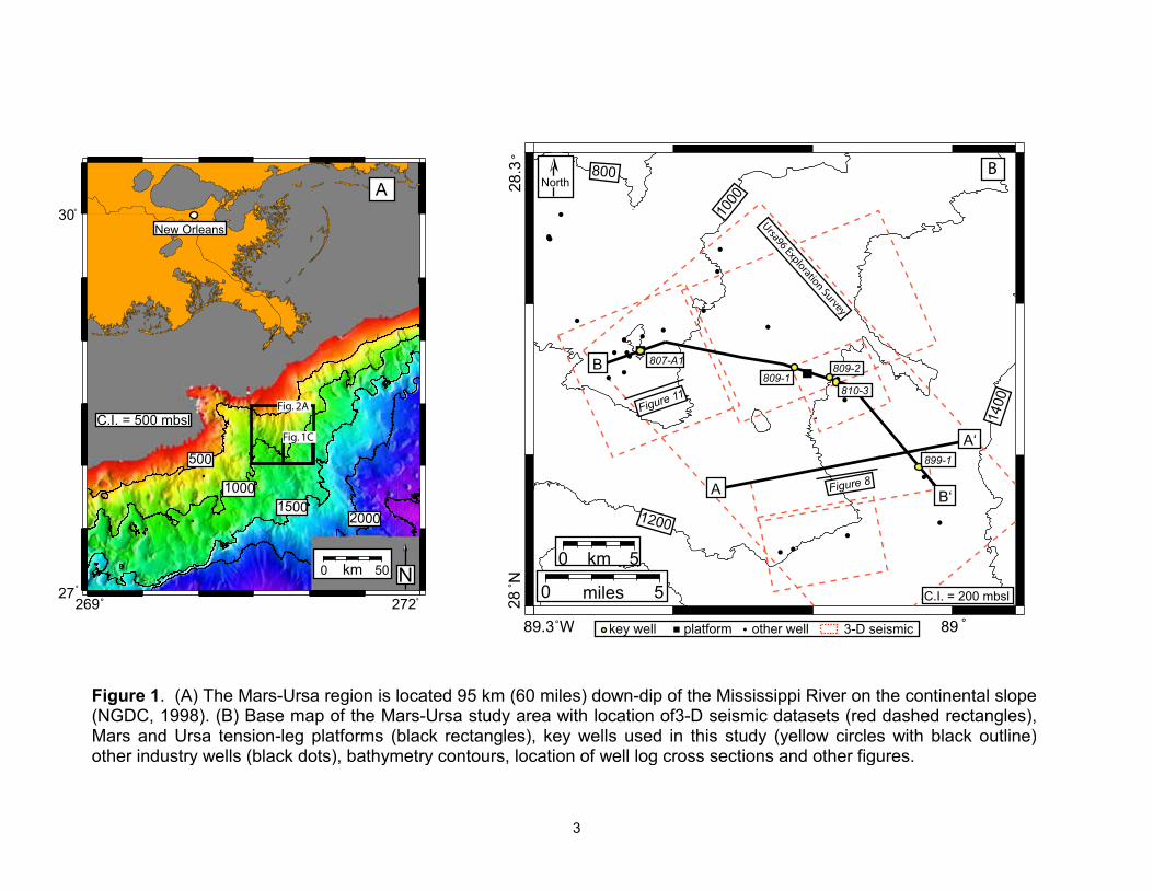
1 Mars-Ursa Region location maps 3
2 Mars-Ursa Region and Schematic Cross Section 5
3 Type Seismic Section and Interpreted Line Drawing 7
4 Type Well log 810-3 8
5 Type Seismic-Log Cross Section 9
6 Base of Blue Unit Time Structure Map 11
7 Top of Blue Unit Time Structure Map 12
8 Blue Unit isochron map 13
9 Base Map of Channel-Levee Systems 16
10 Seimic cross section through Ursa Canyon System 17
11 Lithology of Ursa Canyon Channel Fill and Levee 18
12 Dip Seismic Section Through Ursa Canyon Fill 20
13 Seismic cross section and interpreted line through
Southwest Pass Canyon channel-levee system 21
14 Evolution if Channel-Levee Systems in Mars-Ursa Region 23
This regional datum has been identified on the Mississippi Fan and in other
academic and industry holes in the Gulf of Mexico (Joyce, et al., 1990; Martin, et
al., 1990).
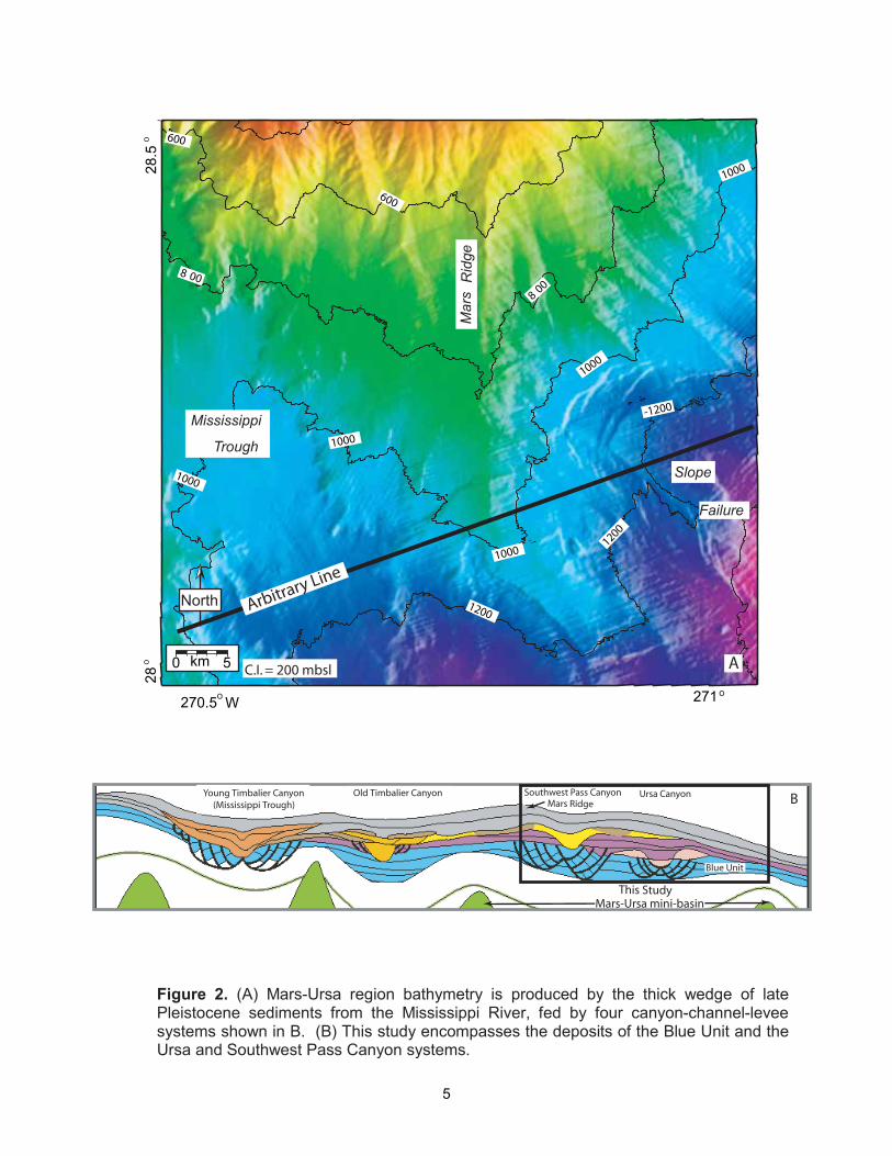
Most of the deposits are associated with four channel-levee systems
which filled and bypassed the region with thick deposits. From oldest to youngest
and from east to west, they are the Ursa, Southwest Pass, Old Timbalier, and
Young Timbalier systems (Figure 2B). Each of these channel-levee systems
transported material from the continental margin to the Mississippi Fan
4
5
throughout the late Pleistocene. All were back-filled and buried except for the
Young Timbalier system, which is still seen on bathymetric charts and referred to
as the Mississippi Trough. This study is within the Ursa and Southwest Pass
channel-levee systems (Figure 2B).
1.3 DEPOSITIONAL ELEMENTS
The depositional elements that have built the stratigraphic succession in
the Mars-Ursa region in the last ~70 ka are, from oldest to youngest, the Blue
Unit, the Ursa Canyon channel-levee system, the Southwest Pass Canyon
channel-levee system, and mass transport deposits (Figure 3). We adopted the
naming convention of Winker and Shipp (2002) yet established our own criteria
for identifying and mapping key stratigraphic surfaces. For each depositional
element, we define mapping criteria, present our observations of seismic and
lithological character, and present our interpretation. We close by describing the
overall evolution of this system.
The Blue Unit
The Blue Unit is composed of interbedded sand and mud (Figure 4 and 5).
The base of the Blue Unit is the base of the deepest sand that ties to a weak
negative amplitude within the shallow sedimentary section (within the exploration
survey, 90-degree phase data) (Figure 4). However, we mapped the positive
seismic amplitude associated with the top of this sand because it was more
regionally mappable than its base. The top of the Blue Unit ties to a positive
seismic amplitude that marks an increase in impedance with depth at the top of
6
7
8
9
sands within the Blue Unit (Figure 4). However, where this surface has been
eroded by channel-levee systems, we mapped the base of the channel levee
systems as the top of the Blue Unit.
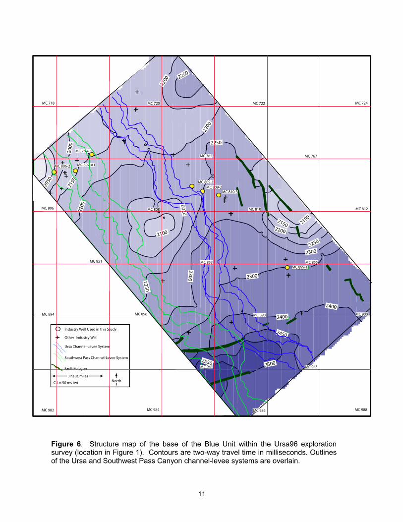
The base of the Blue Unit was correlated in all well logs and was mapped
throughout the exploration seismic data (Figure 6). It is generally planar and dips
to the south at a gradient of ~0.23˚. In the western and southern parts of the
study area, it is truncated by a deformation zone associated with two channel-
levee systems.
Reflections within the Blue Unit are associated with interbedded sand and
mud (Figure 4). Sand bed thicknesses range from a few meters to several tens
of meters and mud layers have similar thicknesses (Figure 4). In some areas,
individual sand-rich members within the Blue Unit could be correlated between
wells (Figure 5). In other cases, correlation was difficult due to chaotic,
discontinuous intervals. This chaotic seismic character within the Blue Unit
represents mass transport deposits within the Blue Unit.
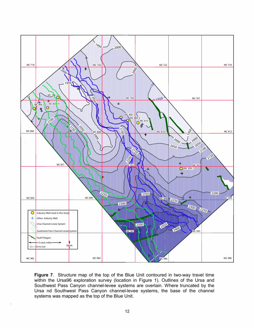
The top of the Blue Unit is difficult to correlate away from the 810-3 well
because of the complex seismic character and significant post-depositional
erosion (Figures 5 and 7). The true top sand of the Blue Unit is truncated by
channel-margin slides associated with two channel-levee systems in the western
half of the study area (Figure 7).
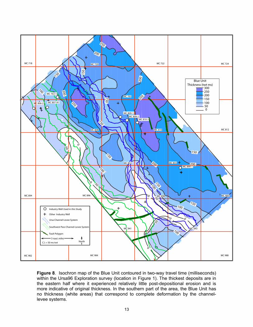
The Blue Unit is thickest in the eastern part of the study and has a
maximum thickness of ~250-300 ms two-way travel time (Figure 8). It pinches
out in the eastern part of the study area and where the Southwest Pass and Ursa
10
11
12
13
channel-levee systems impinge upon it. In the southern part of the study area
beneath the two channel-levee systems, the Blue Unit is completely removed by
channel-margin slides.
Origin of the Blue Unit
We interpret that the Blue Unit was deposited by unconfined-flow turbidity
currents that filled a depression in the Mars-Ursa mini-basin. It could have been
sourced from turbidity currents funneled by channel-levee systems that were
present up-dip on the shelf margin. Multiple sand beds within the Blue Unit imply
multiple stages of turbidite deposition interspersed with quiescent periods of
hemipelagic deposition. The Blue Unit has been referred to as a basin-floor fan
(Winker and Booth, 2000; and Winker and Shipp, 2002). These deposits are
typical in other deep-water fans and have been termed sheet sands, frontal-splay
complexes, depositional lobes, channel termination lobes, and high-amplitude
reflection packages (HARPs) (Mahaffie, 1994; Posamentier and Kolla, 2003;
Fonnesu, 2003; and Deptuck et al., 2003). They often underlie channel-levee
systems (Pirmez et al., 1997).
This Blue Unit was most likely deposited during the MIS Stage 4 eustatic
sea level fall and with the corresponding eastward shift in the drainage pattern of
the Mississippi River that focused deposition up-dip of the Mars-Ursa region
(Pulham, 1993; Winker and Booth, 2000). It was most likely deposited with a
relatively uniform thickness considering outcrop and seismic studies of other
basin-floor fans (King, et al., 1994; Dean et al., 2000). The thickness variations
14
shown in the isochron map are not indicative of original depositional thickness
because of significant post-depositional erosion.
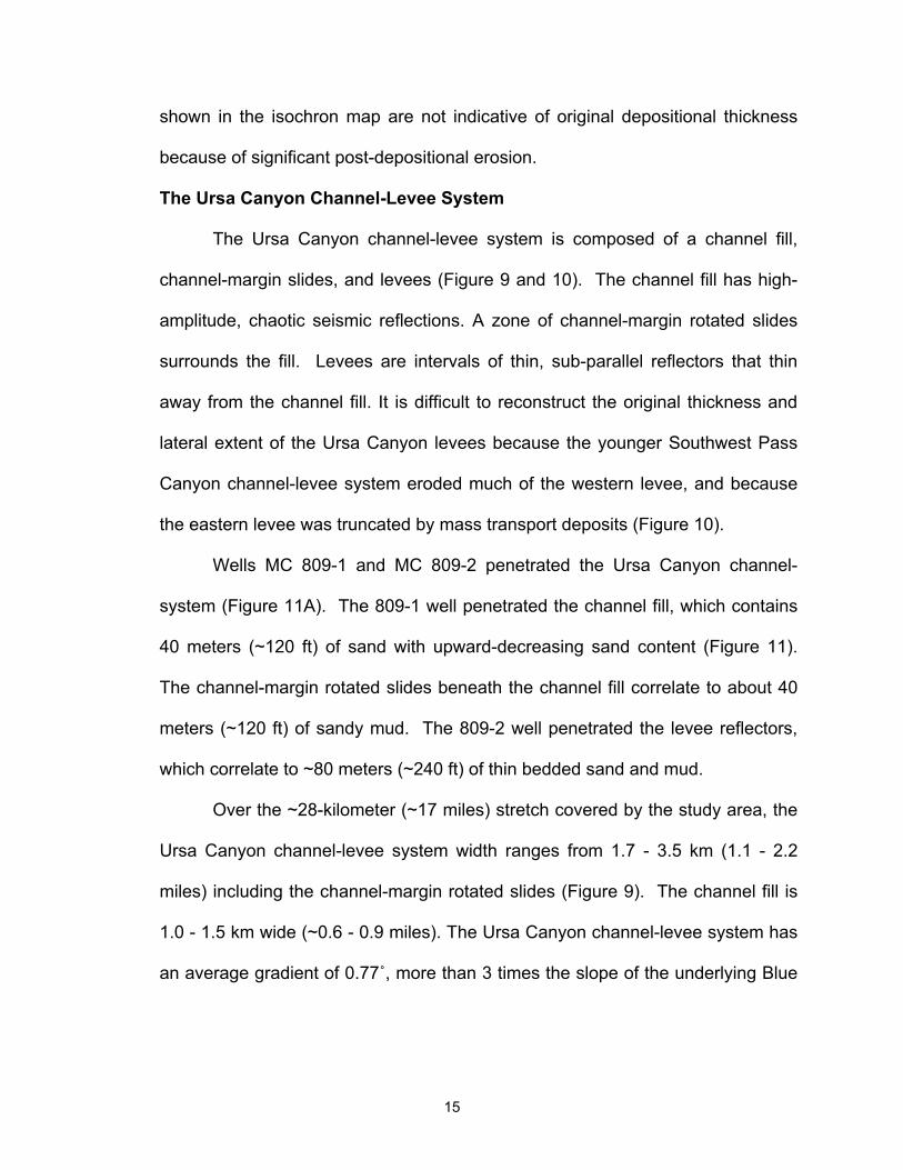
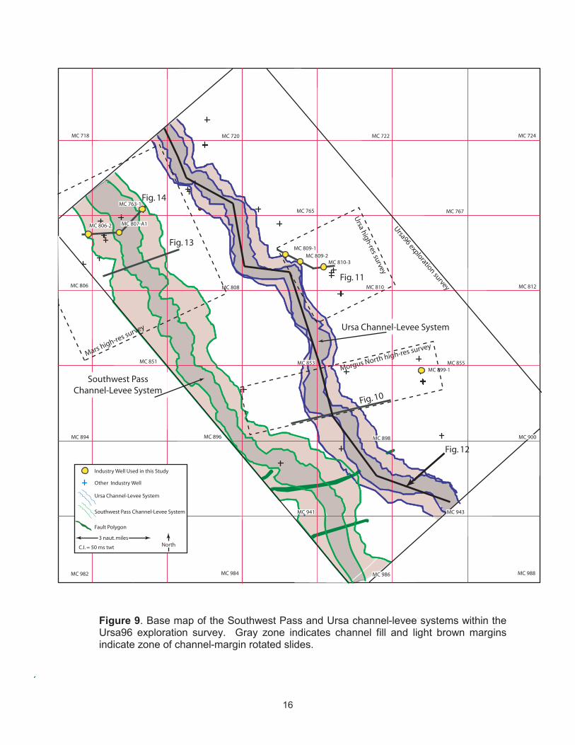
The Ursa Canyon Channel-Levee System
The Ursa Canyon channel-levee system is composed of a channel fill,
channel-margin slides, and levees (Figure 9 and 10). The channel fill has high-
amplitude, chaotic seismic reflections. A zone of channel-margin rotated slides
surrounds the fill. Levees are intervals of thin, sub-parallel reflectors that thin
away from the channel fill. It is difficult to reconstruct the original thickness and
lateral extent of the Ursa Canyon levees because the younger Southwest Pass
Canyon channel-levee system eroded much of the western levee, and because
the eastern levee was truncated by mass transport deposits (Figure 10).
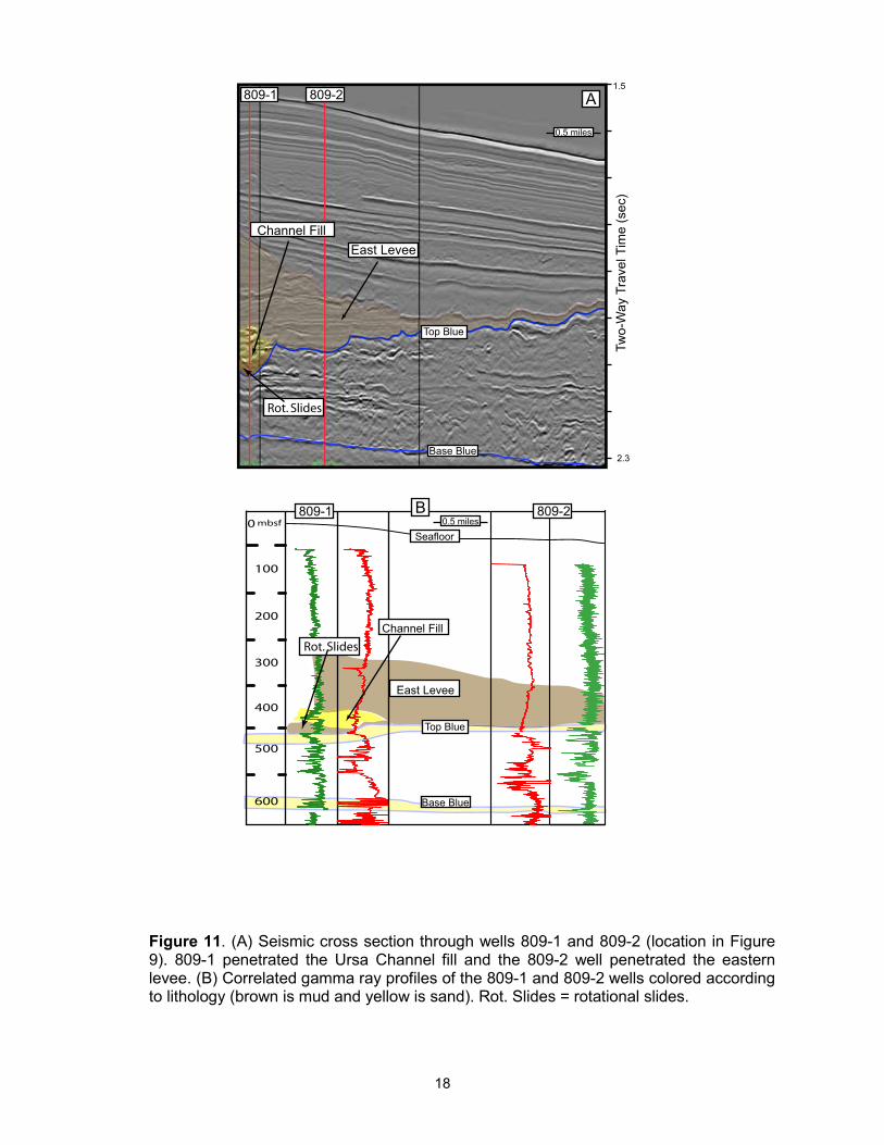
Wells MC 809-1 and MC 809-2 penetrated the Ursa Canyon channel-
system (Figure 11A). The 809-1 well penetrated the channel fill, which contains
40 meters (~120 ft) of sand with upward-decreasing sand content (Figure 11).
The channel-margin rotated slides beneath the channel fill correlate to about 40
meters (~120 ft) of sandy mud. The 809-2 well penetrated the levee reflectors,
which correlate to ~80 meters (~240 ft) of thin bedded sand and mud.
Over the ~28-kilometer (~17 miles) stretch covered by the study area, the
Ursa Canyon channel-levee system width ranges from 1.7 - 3.5 km (1.1 - 2.2
miles) including the channel-margin rotated slides (Figure 9). The channel fill is
1.0 - 1.5 km wide (~0.6 - 0.9 miles). The Ursa Canyon channel-levee system has
an average gradient of 0.77˚, more than 3 times the slope of the underlying Blue
15
16
17
18
Unit. Because of its steeper gradient, the Ursa Canyon channel-levee system
progressively incises more of the Blue Unit from north to south (Figure 12).
The Southwest Pass Canyon Channel-Levee System
The Southwest Pass Canyon channel-levee system is younger and lies to
the west of the Ursa Canyon channel-levee system (Figure 9). It eroded much of
the western levee of the Ursa channel and completely buried the Ursa channel fill
and its eastern levee. It has similar characteristics as the Ursa Canyon channel-
levee system but is larger (Figure 13).
The Southwest Pass Canyon channel-levee system also contains a belt of
rotated channel-margin slides, but it is wider than the Ursa system. It has a
maximum width of 5.5 km (3.4 miles), accounting for the width of the channel-
margin slides (Figure 9). The channel fill itself is approximately 1.3 – 1.6 km
wide (0.8 – 1.0 mile).
The Southwest Pass Canyon channel fill contains several sands 1-7
meters thick (3 – 22 feet), each separated by approximately 5 meters of mud.
This is capped by a 49 meter-thick sand (161 feet) with very thin (<2.5 meters)
beds of mud. The levees of the Southwest Pass Canyon are predominantly
composed of mud, as inferred from the gamma ray profiles of wells 806-1 and
763-1 (Figure 13). The channel-margin rotated slides were penetrated by well
807-A1 below the channel fill and is composed predominantly of mud.
19
20
21
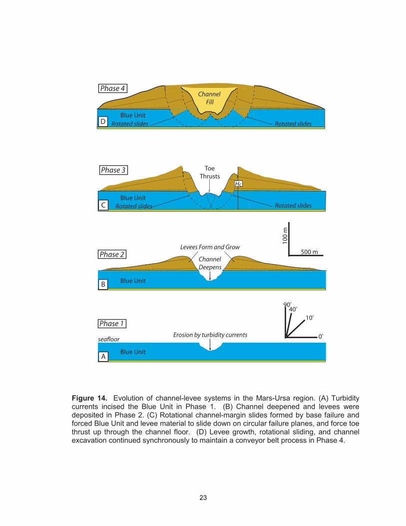
Evolution of Channel-Levee Systems
A two-dimensional model of the origin the channel-levee systems in the
Mars-Ursa region involves four phases (Figure 14). In Phase 1, initial incision
and erosion of the seafloor and the shallow subsurface was accomplished by
turbidity currents (Figure 14A). This established a pathway for subsequent
turbidity currents. In the case of the Ursa Canyon channel-levee system, it
directly incised into the Blue Unit but the Southwest Pass Canyon system incised
and eroded into the western Ursa Canyon levee.
In Phase 2, turbidity currents eroded more Blue Unit material, and the
channel deepened (Figure 14B). Overspill of fine-grained material in the upper
parts of turbidity flows periodically deposited on each side of the channel and
formed levees. During this phase the height (H) of the channel floor to the crest
of the adjacent levees increased.
Rotated channel-margin slides formed in Phase 3 when a critical height
(Hc) of the channel floor to the levee crest was reached (Figure 14C). The weight
of the levees and the lack of lateral support adjacent to the channel triggered
these slides. On each side of the channel, a fault plane formed at the levee
crest, extended into the subsurface below the depth of the channel floor, and
then surfaced as toe thrusts in the channel floor from below (Figure 14C). Each
failure plane defined a slide block that was composed of both levee and
underlying material. Each slide block rotated down and deposited a toe thrust
into the adjacent channel axis. Turbidity currents then entrained this material and
transported it down-channel. The erosion of this material, coupled with continued
22
23
levee growth, promoted a conveyor belt-like process in which turbidity currents
flushed the channel axis while levee growth induced further channel-margin
sliding.
This form of slope failure occurs when the weight of the soil adjoining an
inclined bank is greater than the bearing capacity of the soil (Terzaghi, 1943).
The soil sinks into the subsurface and yields toward the open space. Examples
of deep-seated failures such as those that surround the Ursa and Southwest
Pass channel-levee systems in submarine channel literature are unknown to the
authors. However, similar deep-seated failures occurred during the excavation of
the Panama Canal (Binger, 1948; McCullough, 1978; and Lutton et al., 1979).
Historical accounts after slide events in the Culebra Cut included railroad tracks
being pushed up tens of feet from below by the toe thrusts of the deep-seated
failures.
Shallow-seated channel-margin slides with failure planes that sole out
near the actual floor of the channel are a much more common feature of both
subaerial and submarine channels. Examples have been observed in Paleozoic
outcrops of alluvial channels in central Pennsylvania, in the modern day Red
River in Canada, and in subsurface deep-water channels (Williams, et al., 1965;
Williams et al., 1985; Beaubouef and Friedmann, 2000; Brooks, 2003; Deptuck
et al., 2003).
During Phase 4, the channel was back-filled and terminated channel-
margin sliding (Figure 14D). Channel backfilling occurs in response to changes in
base level, which exert a strong control on submarine channel equilibrium,
24
including headward migration of knickpoints, which can lead to channel
backfilling (Beaubouef and Friedmann, 2000; Pirmez et al., 2000). Once the
channel backfilled, subsequent turbidity currents were eventually forced to
breach the confinement of the channel and spillover, thereby establishing new
turbidite pathways and the start of a new channel-levee system.
Mass Transport Deposits
Numerous mass transport deposits exist within the mud-rich levee
deposits above the Blue Unit (Figure 3, 5, and 15). They are characterized by a
high-amplitude reflector at the base of a semi-transparent seismic interval with
steeply dipping sidewall scarps that truncate otherwise sub-parallel reflectors
(Figure 15). The high-amplitude reflector at the base of mass transport deposits
is the detachment surface along which the failure event slipped. In some cases
the detachment surface is irregular and cross-cuts stratigraphy, in other cases it
is flat (Figures 3, 4, and 15). Mass Transport Deposit 1 (MTD1) occurred on the
eastern levee of the Ursa Canyon channel-levee system and Mass Transport
Deposit 2 (MTD2) occurred within the eastern levee of the Southwest Pass
Canyon channel-levee system. MTD2 is a prominent feature but is much larger
than the size of the study area here and will not be discussed further.
MTD 1 truncated the sub-parallel, continuous reflectors on the eastern
levee of the Ursa Canyon channel-levee system (Figure 10 and 15). There were
actually two failures: MTD 1A and MTD1B (Figure 15). MTD1B lies entirely within
MTD1A. In map view, both events widen to the southeast, revealing the failure
direction. The headwall scarp of MTD1B, which is the up-dip limit of the paleo-
25
26
failure, and the sidewall scarps of MTD1B can both be seen in map view (Figure
15B). However, only the sidewall scarps of MTD1A are visible, the headscarp is
farther north. Linear grooves in the detachment surface of MTD1A trend to the
southeast, and also indicate the failure direction to be to the southeast.
Origin and Evolution of Mass Transport Deposits
Mass transport deposits have been observed in recent subsurface seismic
studies, (Brami et al., 2000; Deptuck et al., 2003; Posamentier and Kolla, 2003;
Gee et al., 2005). The seismic character of deposits above detachment surfaces
range from low-amplitude chaotic to transparent and it is often assumed that they
are the remobilized material that originally failed (Brami et al., 2000; Posamentier
and Kolla, 2003, Gee et al., 2005). Linear scours (>10 km long (>6 miles)) on the
detachment surfaces of mass transport deposits have been interpreted to
originate from slide blocks lodged at the base of mass transport deposits (Brami
et al., 2000; Posamentier and Kolla, 2003, Gee et al., 2005).
Mass transport deposits occur because shear strength is exceeded by the
shear stress, and this can occur for a number of reasons. In environments where
sediments are rapidly deposited, overpressures can develop, which decreases
the strength of the sediment. Geotechnical studies, including in-situ pore
pressure measurements, established the presence of pore pressures significantly
above hydrostatic within the shallow strata of this study area (Ostermeier et al.,
2000). Dugan and Flemings (2000) (2002), and Flemings et al., (2002) describe
how rapid, asymmetric loading of an underlying permeable unit results in low
27
effective stresses where the overburden is thin. The concentration of mass
transport deposits where the overburden is thin at Ursa suggests that this
process may be occurring.
1.4 DISCUSSION
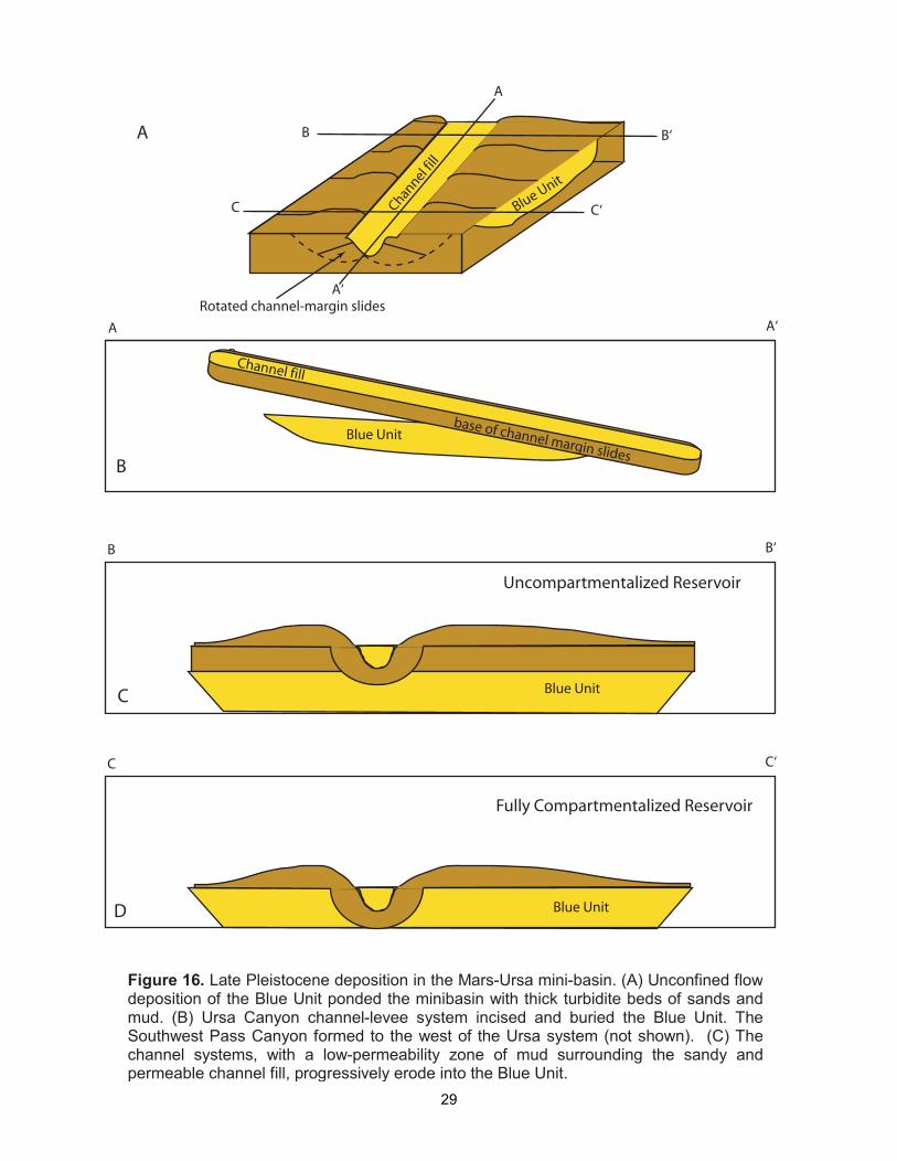
We summarize the paleogeographic evolution of the last 70 ka in the
Mars-Ursa region (Figure 16). The Blue Unit ponded within topographic
depressions on the continental slope and formed a regionally connected sand-
rich body extending as much as 150 km (~90 miles) east-west and 75 km (~45
miles) north-south (Winker and Booth, 2000). At the scale of our study area, the
Blue Unit is envisioned as several sand bodies 10s of meters thick interbedded
with mud 10s of meters thick.
After the Blue Unit ponded the paleo-depression with sand-rich turbidites,
the Ursa Canyon channel-levee system developed and funneled sandy turbidites
down-dip. During this period of bypass, the Ursa Canyon channel-levee system
incised some depth into the Blue Unit and developed thick mud-rich levees.
Enough channel relief formed by channel incision and levee construction to
cause base failure on the eastern and western channel margins (Figure 16B).
Rotated channel-margin slides on the levee flanks penetrated deeper than the
channel floor itself.
The Southwest Pass Canyon channel-levee system formed to the west of
the Ursa Canyon system. It is much larger than the Ursa Canyon channel–levee
system and its eastern levee is responsible for the significant west-to-east
28
29
thinning overburden above the Blue Unit. Weimer (1990) describes how this
channel-levee system branches into 8 subsidiary channels farther down slope on
the Mississippi Fan.
The superposition of leveed channel turbidite deposits above sheet-sand
turbidite deposits has long been proposed as a characteristic record of the
eustatic cycle. These models argue that a change in the flux of sediment to the
shelf margin may drive this shift in depositional processes. (Vail et al., 1977;
Posamentier and Vail, 1988). Alternatively, others have argued that the evolution
from ponded sheet sands, to levee-channel sands, to bypass, is a natural result
of the decrease in accommodation that results as sediment fills accommodation
during prolonged base level fall (Prather, 1998; Winker and Booth, 2000).
This seismic resolution possible with this study provides important clues to
understand reservoir compartmentalization. As a result of the difference in slope
between the nearly flat Blue Unit and the overlying, southward-dipping, channel-
levee systems, these components are separated in the north, yet amalgamated
in the south (Figures 12 and 16C). To the south, where the channels completely
deform the underlying Blue Unit, a broad, mud-rich zone of channel-margin
rotated slides surrounds the sandy and permeable channel fill. As a result, the
channel-levee systems act as permeability barriers. The hydraulic connectivity of
the Blue Unit is compromised by this phenomenon, especially in the southern
part of the study area where the Blue Unit is completely deformed (Figure 8).
Rotated channel-margin slides in the channel-levee systems results in an
intriguing stratigraphic paradox. During the bypass phase, significant erosion at
30
the channel base may continually occur, yet the channel floors themselves do not
move downward because material is continually replaced by the toe thrusts of
the rotating slide blocks. Thus a channel may be at grade (neither moving
upward nor downward), yet continually eroding its base.
1.5 CONCLUSIONS
We have presented the seismic geomorphology and lithology of the main
depositional elements deposited in the Mars-Ursa region in the last 70 ka. The
Blue Unit is a basin-floor fan that ponded a topographic depression in the Mars-
Ursa Region with interbedded sand and mud. Two channel-levee systems
plunged from north to south into the Blue Unit. Each of the channel-levee
systems deposited a package of eastward thinning mud-rich levee sediments
that asymmetrically buried the Blue Unit. Spectacular, rotated channel-margin
slides formed around the channel fill of each channel-levee system. This resulted
in a zone of mud-rich sediments that surrounded the sandy channel fill, which
created a permeability barrier within the Blue Unit.
This study provides insight into the architectural building blocks of a deep-
water turbidite systems and it can be used to design well plans in the shallow
section. The steeper gradient of the levee-channel systems relative to the
underlying sheet sands results in a system where, within a few tens of
kilometers, these components transition from being detached to amalgamated.
The channels themselves are surrounded by low permeable mud even when
they incise sands of the Blue Unit. At the broadest level, the integration of high
31
resolution 3-D seismic data with well data in the shallow subsurface provides an
extraordinary opportunity to examine the distribution, lithology, and connectivity
of deep-water turbidite sands.
32
REFERENCES CITED
Beaubouef, R. T., and S. J. Friedmann, 2000, High resolution seismic/sequence stratigraphic framework for the evolution of Pleistocene intra slope basins, western Gulf of Mexico, depositional models and reservoir analogs, in P. Weimer, R. M. Slatt, J. Coleman, N. C. Rosen, H. Nelson, A. H. Bouma, M. J. Styzen, and D. T. Lawrence, eds., Deep-water Reservoirs of the World: SEPM Gulf Coast Section 20th Annual Research Conference, p. 40-60.
Binger, W. V., 1948, Analytical studies of Panama Canal slides: Proceedings of the 2nd International Conference on Soil Mechanics and Foundation Engineering, v. 2, p. 54-60.
Brami, T. R., C. Pirmez, C. Archie, S. Heeraldal, and K. L. Holman, 2000, Late Pleistocene deep-water stratigraphy and depositional processes, offshore Trinidad and Tobago, in P. Weimer, R. M. Slatt, J. Coleman, N. C. Rosen, H. Nelson, A. H. Bouma, M. J. Styzen, and D. T. Lawrence, eds., Deep-water Reservoirs of the World: SEPM Gulf Coast Section 20th Annual Research Conference, p. 104-115.
Brooks, G. B., 2003, Alluvial deposits of a mud-dominated stream: The Red River, Manitoba, Canada: Sedimentology, v. 50, p. 441-458.
Coleman, J. M., and H. H. Roberts, 1988, Late Quaternary depositional framework of the Louisiana continental shelf and upper continental slope: Transactions of the Gulf Coast Association of Geological Societies, p. 407-419.
Dean, M. C., K. M. King, and J. R. Booth, 2000, The present is the key to the Plio-Pleistocene: seafloor analogues at Shell's GB 516 Serrano discovery: Deep-water reservoirs of the world, in P. Weimer, R. M. Slatt, J. Coleman, N. C. Rosen, H. Nelson, A. H. Bouma, M. J. Styzen, and D. T. Lawrence, eds., Deep-water Reservoirs of the World, SEPM Gulf Coast Section 20th Annual Research Conference, p. 293-303.
Deptuck, M. E., G. S. Steffens, M. Barton, and C. Pirmez, 2003, Architecture and evolution of upper fan channel-belts on the Niger Delta slope and in the Arabian Sea: Marine and Petroleum Geology, v. 20, p. 649-676.
Dugan, B., and P. B. Flemings, 2000, Overpressure and fluid flow in the New Jersey continental slope: implications for slope failure and cold seeps: Science, v. 289, p. 288-291.
17
33
Dugan, B., and P. B. Flemings, 2002, Fluid flow and stability of the US continental slope offshore New Jersey from the Pleistocene to the present: Geofluids, v. 2, p. 137-146.
Eaton, L. F., 1999, Drilling through deepwater shallow water flow zones at Ursa: Society of Petroleum Engineers/International Association of Drilling Contractors, paper # 52780, presented in the 1999 SPE/IADC drilling conference, Amsterdam, March 9-11, p. 153-164.
Flemings, P. B., B. B. Stump, T. Finkbeiner, and M. Zoback, 2002, Flow focusing in overpressured sands: theory, observations, and applications: American Journal of Science, v. 302, p. 827-855.
Fonnesu, F., 2003, 3D seismic images of a low-sinuosity slope channel and related depositional lobe (West Africa deep-offshore): Marine and Petroleum Geology, v. 20, p. 615-629.
Gee, M. J. R., R. L. Gawthorpe, and J. S. Friedmann, 2005, Giant striations at the base of a submarine landslide: Marine Geology, v. 214, p. 287-294.
Joyce, J. E., L. R. C. Tjalsma, and J. M. Prutzman, 1990, High-resolution planktic stable isotope record and spectral analysis for the last 5.35 m.y.:Ocean Drilling Program Site 625 northeast Gulf of Mexico: Paleoceanography, v. 5, p. 507-529.
King, P., G. H. Browne, and R. M. Slatt, 1994, Sequence architecture of exposed late Miocene basin floor fan and channel-levee complexes (Mount Messenger Formation), Taranaki Basin, New Zealand, in P. Weimer, A. H. Bouma, and B. G. Perkins, eds., Submarine fans and turbidite systems: SEPM Gulf Coast Section 15th Annual Research Conference, p. 177-192.
Lutton, R. J., D. C. Banks, and W. E. Strohm Jr., 1979, Slides in Gaillard Cut, Panama Canal zone, in B. Voight, ed. Rockslides and Avalanches, v. 2, p. 151-224.
Mahaffie, M. J., 1994, Reservoir classification for turbidite intervals at the Mars discovery, Mississippi Canyon 807, Gulf of Mexico, in P. Weimer, A. H. Bouma, and B. G. Perkins, eds., Submarine fans and turbidite systems: SEPM Gulf Coast Section 15th Annual Research Conference, p. 233-244.
Martin, R. E., G. W. Johnson, E. D. Neff, and D. W. Krantz, 1990, Quaternary planktonic foraminiferal assemblage zones of the northeast Gulf of Mexico, Columbia Basin (Caribbean Sea), and tropical Atlantic Ocean:
18
34
graphic correlation of microfossil and oxygen isotope datums: Paleoceanography, v. 5, p. 531-555.
McAdoo, B. G., L. F. Pratson, and D. L. Orange, 2000, Submarine landslide geomorphology, US continental slope: Marine Geology, v. 169, p. 103-136.
McCullough, D., 1978, Path Between the Seas: The Creation of the Panama Canal, 1870-1914: Simon & Schuster, 704 p.
McFarlan, E., and D. O. LeRoy, 1988, Subsurface geology of the Late Tertiary and Quaternary deposits, coastal Louisiana, and the adjacent continental shelf: Gulf Coast Association of the Geological Societies Transactions, v.38, p. 421-433.
National Geophysical Data Center, 1998, http://www.ngdc.noaa.gov/mgg/bathymetry/hydro.html
Accessed December 01, 2005.
Ostermeier, R. M., J. H. Pelletier, C. D. Winker, J. W. Nicholson, F. H. Rambow, and C. K. Cowan, 2000, Dealing with shallow-water flow in the deepwater Gulf of Mexico: Offshore Technology Conference Paper 11972, p. 75-86.
Pirmez, C., R. N. Hiscott, and J. D. Kronen Jr., 1997, Sandy turbidite successions at the base of channel-levee systems of the Amazon Fan revealed by FMS logs and cores: unraveling the facies architecture of large submarine fans, Chapter 2, in R. D. Flood, D. J. W. Piper, A. Klaus, and L. C. Peterson, eds., Proceedings of the Ocean Drilling Program Leg 155: Scientific Results, v. 155, p. 7-33.
Pirmez, C., R. T. Beaubouef, S. J. Friedmann, and D. C. Mohrig, 2000, Equilibrium profile and baselevel in submarine channels: examples from Late Pleistocene systems and implications for the architecture of deepwater reservoirs, in P. Weimer, R. M. Slatt, J. Coleman, N. C. Rosen, H. Nelson, A. H. Bouma, M. J. Styzen, and D. T. Lawrence, eds., Deep-water Reservoirs of the World: SEPM Gulf Coast Section 20th Annual Research Conference, p. 782-805.
Pirmez, C., and J. Imram, 2003, Reconstruction of turbidity currents in Amazon Channel: Marine and Petroleum Geology, v. 20, p. 823-849.
Posamentier, H. W., and P.R. Vail, 1988, Eustatic controls on clastic deposition II-sequence and systems tract models, in C. K. Wilgus, B. S. Hastings, C. G. St. C. Kendall, H. W. Posamentier, C. A. Ross, and J. C. Van Wagoner,
19
35
eds., Sea-Level Changes: An Integrated Approach, SEPM Special Publication 42, p. 125-154.
Posamentier, H., and V. Kolla, 2003, Seismic geomorphology and stratigraphy of depositional elements in deep-water settings: Journal of Sedimentary Research, v. 73, p. 367-388.
Prather, B. E., J. R. Booth, G. S. Steffens, and P. A. Craig, 1998, Classification, lithologic calibration, and stratigraphic succession of seismic facies of intraslope basins, deep-water Gulf of Mexico: AAPG Bulletin, v. 82, p. 701-728.
Pulham, A. J., 1993, Variations in slope deposition, Pliocene-Pleistocene, offshore Louisiana, northeast Gulf of Mexico, in H. Posamentier, and P. Weimer, eds., Siliciclastic sequence stratigraphy: Recent Developments and Applications: AAPG Memoir 58, p. 199-233.
Saller, A. H., J. T. Noah, A. P. Ruzuar, and R. Schneider, 2004, Linked lowstand delta to basin-floor fan deposition, offshore Indonesia: An analog for deep-water reservoir systems: AAPG Bulletin, v. 88, p. 21-46.
Styzen, M. J., 1996, A chart in two sheets of the late Cenozoic chronostratigraphy of the Gulf of Mexico, SEPM Gulf Coast Section, publication #GCS407.
Terzaghi, K., 1943, Theoretical Soil Mechanics: Chapman and Hall, 510 p.
Vail, P. R., R. M. Mitchum Jr., and S. Thompson III, 1977, Seismic stratigraphy and global changes of sea level, Part 3: Relative changes of sea level from coastal onlap, in C. E. Payton, ed., Seismic Stratigraphy-Applications to Hydrocarbon Exploration: AAPG Memoir 26, p. 63-81.
Weimer, P., 1990, Sequence stratigraphy, facies geometries, and depositional history of the Mississippi Fan, Gulf of Mexico: AAPG Bulletin, v. 74, p. 425-453.
Williams, E. G., A. L. Guber, and A. M. Johnson, 1965, Rotational slumping and the recognition of disconformities: Journal of Geology, v. 73, p. 534-547.
Williams, E. G., T. W. Gardner, A. Davis, R. R. Parizek, A. W. Rose, and W. Bragonier, 1985, Field guide #5, economic and mining aspects of the coal-bearing rocks in western Pennsylvania: 50th annual field conference of Pennsylvania geologists, Central Pennsylvania Geology Revisited, p. 275-290.
20
36
Winker, C. D., and J. R. Booth, 2000, Sedimentary dynamics of the salt-dominated continental slope, Gulf of Mexico: Integration of observations from the seafloor, near-surface, and deep subsurface, in P. Weimer, R. M. Slatt, J. Coleman, N. C. Rosen, H. Nelson, A. H. Bouma, M. J. Styzen, and D. T. Lawrence, eds., Deep-water Reservoirs of the World: SEPM Gulf Coast Section 20th Annual Research Conference, p. 1059-1086.
Winker, C. D., and R. C. Shipp, 2002, Sequence stratigraphic framework for prediction of shallow water flow in the greater Mars-Ursa Area, Mississippi Canyon Area, Gulf of Mexico continental slope (abs.), in J. Armentrout, ed., Sequence stratigraphic models for exploration and production: evolving methodology, emerging models, and application histories: SEPM Gulf Coast Section 22nd Annual Research Conference, http://www.gcssepm.org/pubs/2002_ab_56.htm.