Pure appl. geophys. 157 (2000) 171–184 0033 – 4553/00/020171–14 $ 1.50 +0.20/0 Seismic Zoning of Slovenia Based on Deterministic Hazard Computations MLADEN Z & IVC ˇ IC ´ , 1 PETER SUHADOLC 2 and FRANCO VACCARI 3 Abstract — Seismic hazard of the territory of Slovenia is estimated using a deterministic approach based on the computation of complete synthetic seismograms. The input data are the catalogues of earthquakes and fault plane solutions for Slovenia and surrounding regions. Structural models are defined based on available seismological and geophysical information, but are mainly constrained by surface-wave dispersion and 3-D tomographic modelling of the upper crust. Seismogenic zones are delineated considering geotectonic characteristics, fault plane solutions and distribution of earthquake hypocentres. Outside Slovenia seismogenic zones are extended up to distances from which they can considerably influence seismic hazard estimates. Synthetic seismograms are computed using the ‘‘receiver’’ structure along the entire path by normal mode summation (up to 1 Hz) for receiver sites on a 0.2 ×0.2 degrees grid and scaled to the magnitude of the earthquake allowing for spectral falloff. At each site the maximum value of horizontal velocity, horizontal displacement and design ground acceleration are considered as hazard parameter. The highest values are obtained for western Slovenia where the hazard is controlled by the strongest earthquake in the catalogue, the ‘‘Idrija’’ event of March 26, 1511. Key words: Seismic hazard, seismic zoning, Slovenia. Introduction Studies of the seismic hazard of Slovenia were mostly performed for regulatory purposes. The first seismic map of Slovenia was proposed in 1963 (BUBNOV, 1996) and was based on maximum observed intensities. This map was further improved within the UNESCO/UNDP project on seismicity of the Balkan region (CVI- JANOVIC ´ , ed., 1974). RIBARIC ˇ (1986) published a revised map of maximal observed intensities in Slovenia and it can be considered the last published seismic hazard map based on a deterministic approach. A probabilistic approach was used for the first time when compiling the 1981 Seismic Building Code, an integral part of which was also a seismic hazard map for the territory of former Yugoslavia. For 1 Geophysical Survey of Slovenia, Observatory, Pot na Golovec 25, SI-1000 Ljubljana, Slovenia and Slovenian Association for Geodesy and Geophysics, Kersnikova 3/II, SI-1000 Ljubljana, Slovenia. 2 Department of Earth Sciences, University of Trieste, Via E. Weiss 1, I-34127 Trieste, Italy. 3 Department of Earth Sciences, University of Trieste, Via E. Weiss 1, I-34127 Trieste, Italy and CNR-GNDT, Gruppo Nazionale per la Difesa dai Terremoti, via Nizza 128, I-00198 Roma, Italy.
Transcript
Pure appl. geophys. 157 (2000) 171–1840033–4553/00/020171–14 $ 1.50+0.20/0
Seismic Zoning of Slovenia Based on Deterministic HazardComputations
MLADEN Z& IVCIC,1 PETER SUHADOLC2 and FRANCO VACCARI3
Abstract—Seismic hazard of the territory of Slovenia is estimated using a deterministic approachbased on the computation of complete synthetic seismograms. The input data are the catalogues ofearthquakes and fault plane solutions for Slovenia and surrounding regions. Structural models aredefined based on available seismological and geophysical information, but are mainly constrained bysurface-wave dispersion and 3-D tomographic modelling of the upper crust. Seismogenic zones aredelineated considering geotectonic characteristics, fault plane solutions and distribution of earthquakehypocentres. Outside Slovenia seismogenic zones are extended up to distances from which they canconsiderably influence seismic hazard estimates.
Synthetic seismograms are computed using the ‘‘receiver’’ structure along the entire path by normalmode summation (up to 1 Hz) for receiver sites on a 0.2×0.2 degrees grid and scaled to the magnitudeof the earthquake allowing for spectral falloff. At each site the maximum value of horizontal velocity,horizontal displacement and design ground acceleration are considered as hazard parameter. The highestvalues are obtained for western Slovenia where the hazard is controlled by the strongest earthquake inthe catalogue, the ‘‘Idrija’’ event of March 26, 1511.
Studies of the seismic hazard of Slovenia were mostly performed for regulatorypurposes. The first seismic map of Slovenia was proposed in 1963 (BUBNOV, 1996)and was based on maximum observed intensities. This map was further improvedwithin the UNESCO/UNDP project on seismicity of the Balkan region (CVI-
JANOVIC, ed., 1974). RIBARIC (1986) published a revised map of maximal observedintensities in Slovenia and it can be considered the last published seismic hazardmap based on a deterministic approach. A probabilistic approach was used for thefirst time when compiling the 1981 Seismic Building Code, an integral part of whichwas also a seismic hazard map for the territory of former Yugoslavia. For
1 Geophysical Survey of Slovenia, Observatory, Pot na Golovec 25, SI-1000 Ljubljana, Slovenia andSlovenian Association for Geodesy and Geophysics, Kersnikova 3/II, SI-1000 Ljubljana, Slovenia.
2 Department of Earth Sciences, University of Trieste, Via E. Weiss 1, I-34127 Trieste, Italy.3 Department of Earth Sciences, University of Trieste, Via E. Weiss 1, I-34127 Trieste, Italy and
CNR-GNDT, Gruppo Nazionale per la Difesa dai Terremoti, via Nizza 128, I-00198 Roma, Italy.
Mladen Z& ivcic et al.172 Pure appl. geophys.,
Slovenia the Gumbel distribution of extremes was used to estimate expectedintensities for return periods of 50, 100, 200, 500, 1000 and 10,000 years (ZAJED-
NICA ZA SEIZMOLOGIJU SFRJ, 1987) LAPAJNE et al. (1995) published the first mapconsistent with the European prestandard Eurocode 8, using the probabilisticapproach of CORNELL (1968). Later on, LAPAJNE et al. (1997a,b) proposed severalmodified versions based on recent developments of seismic hazard assessment(FRANKEL, 1995).
The seismic hazard of Slovenia was also considered in regional studies. SLEJKO
and KIJKO (1991), in their study of seismic hazard of the main seismogenic zonesin the Eastern Alps, included a large part of Slovenia in Ljubljana and Rijekaseismic zones.
The main objective of this study is to assess the appropriateness of thedeterministic approach of COSTA et al. (1993), considering the size of the territoryand the level of seismicity, as well as the level of detail with which seismic hazardcan reasonably be mapped using this methodology.
Seismicity
Slovenia lies at the northeastern rim of the Adriatic microplate. Its seismicity iscontrolled by the geodynamic setting of the country within three large geotectonicunits: the Alps, the Dinarides and the Pannonian basin, and is mainly constrainedto the regions where these units are in direct contact.
Studies of seismicity of Slovenia (as well as that of neighbouring countries) relymostly on macroseismic data (RIBARIC, 1982). Until the late 1980s the number anddistribution of seismological stations in Slovenia did not allow for the reliableestimate of earthquake parameters from instrumental records. It is estimated thatthe catalogue can be considered reasonably complete for magnitudes above 3.7 forthe period after 1870 (LAPAJNE et al., 1997b). As the largest magnitude since 1870is estimated (using macroseismic data) to be 6.1 (the Ljubljana 1895 event), therange of completeness and the territory covered do not allow a reliable use ofstatistical methods (e.g., KRINITZSKY, 1995).
A good earthquake catalogue is required for every seismic hazard assessment.Many parts of Slovenia suffered major damage from earthquakes that originatedoutside its political boundaries. The strongest are the 1976 Friuli earthquake andtwo historical events in the Friuli-Carnia region, in 1348 and 1690. For the purposeof the seismic hazard assessment for the territory of Slovenia, we assembled acatalogue covering the region between 44.5–47.5°N and 12.5–17.5°E. The existingcatalogues for the regions that surround Slovenia are rather inhomogeneous asregards their completeness as well as the methods used to derive earthquakeparameters (CVIJANOVIC, 1981; ZSIROS et al., 1988; FIEGWEIL, 1981; OGS, 1992;and references therein). Therefore, the individual catalogues have been merged
Deterministic Seismic Hazard in Slovenia 173Vol. 157, 2000
following the principle to retain the parameters determined in each catalogue onlyfor events lying on the respective national territory. We therefore use ZSIROS et al.(1988) parameters for events originating in Hungary and so on. Intensity is used asa measure of earthquake size for pre-1901 earthquakes. MCS and MSK scales usedin different sources are assumed to be equivalent (WILLMORE, ed., 1979). Forpost-1900 earthquakes magnitude MLH as defined by KARNIK (1968) is used sincethe majority of earthquake magnitudes was determined uniformly when compilingthe KARNIK (1968, 1971) catalogue and the catalogue of earthquakes in BalkanRegion (SHEBALIN et al., 1974). Our merged catalogue contains earthquakes in theregion 44.5–47.5°N and 12.5–17.5°E and we estimate it to be complete forintensities VI MSK and greater since 1890. However for deterministic hazardestimation purposes, only locations and magnitudes of the strongest earthquakesare of importance.
In estimating earthquake hazard it is of great importance to have a unifiedmeasure of the earthquake size. For historical events no instrumental data areavailable and magnitudes have to be estimated from macroseismic data. Therelations between magnitude MLH and isoseismal radii as determined from goodquality isoseismal maps, have been derived from 20th century earthquake data.
For eighteen earthquakes both isoseismal maps and MLH magnitudes areavailable. This has enabled us to derive relations for the estimation of magnitudesfrom macroseismic data. Isoseismals have been digitised and the relations betweenmagnitude MLH and equivalent radii R of isoseismals, as well as between MLH andepicentral intensity Io and focal depth h, are derived:
The relations are derived for intensities IV, V and VI MSK because there arenot enough strong earthquakes in the 20th century which would provide data forcalibrating magnitude formulas for higher intensities. The strongest earthquake inthe 20th century was of magnitude MLH=5.7 and intensity VIII MSK. Magnitudesof historical events are therefore estimated from macroseismic data. The averagevalue obtained using the above relations is adopted as macroseismic magnitudeMM. For that purpose we considered all earthquakes for which macroseismic dataas well as instrumentally determined magnitude are available. The macroseismicmagnitudes, MM, of the two strongest earthquakes are:
26.03.1511. MM=6.890.3
14.04.1895 MM=6.190.2.
Mladen Z& ivcic et al.174 Pure appl. geophys.,
The 1976 earthquake with epicentre in Friuli (Italy) was used for control—itsmacroseismically estimated magnitude is MM=6.190.1, whereas its instrumentalmagnitude estimates range from Mb=5.9 to Ms=6.5 (ISC, 1976).
Seismogenic Structures and Earthquake Mechanisms
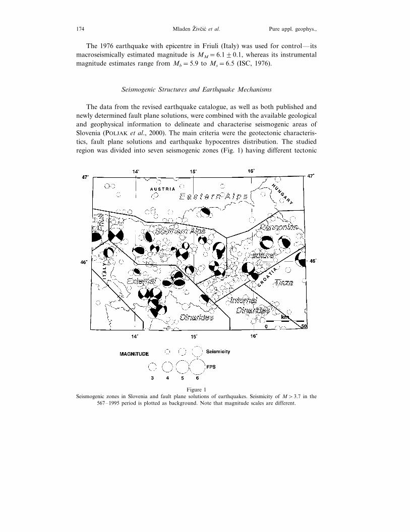
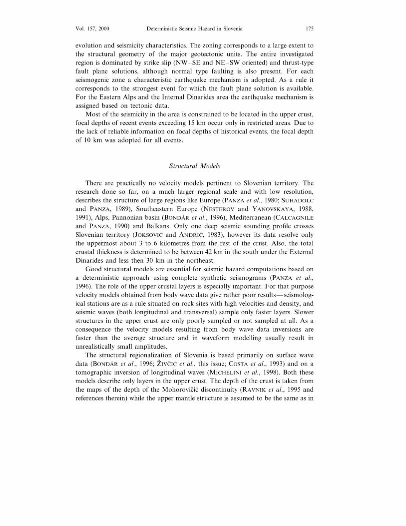
The data from the revised earthquake catalogue, as well as both published andnewly determined fault plane solutions, were combined with the available geologicaland geophysical information to delineate and characterise seismogenic areas ofSlovenia (POLJAK et al., 2000). The main criteria were the geotectonic characteris-tics, fault plane solutions and earthquake hypocentres distribution. The studiedregion was divided into seven seismogenic zones (Fig. 1) having different tectonic
Figure 1Seismogenic zones in Slovenia and fault plane solutions of earthquakes. Seismicity of M\3.7 in the
567–1995 period is plotted as background. Note that magnitude scales are different.
Deterministic Seismic Hazard in Slovenia 175Vol. 157, 2000
evolution and seismicity characteristics. The zoning corresponds to a large extent tothe structural geometry of the major geotectonic units. The entire investigatedregion is dominated by strike slip (NW–SE and NE–SW oriented) and thrust-typefault plane solutions, although normal type faulting is also present. For eachseismogenic zone a characteristic earthquake mechanism is adopted. As a rule itcorresponds to the strongest event for which the fault plane solution is available.For the Eastern Alps and the Internal Dinarides area the earthquake mechanism isassigned based on tectonic data.
Most of the seismicity in the area is constrained to be located in the upper crust,focal depths of recent events exceeding 15 km occur only in restricted areas. Due tothe lack of reliable information on focal depths of historical events, the focal depthof 10 km was adopted for all events.
Structural Models
There are practically no velocity models pertinent to Slovenian territory. Theresearch done so far, on a much larger regional scale and with low resolution,describes the structure of large regions like Europe (PANZA et al., 1980; SUHADOLC
and PANZA, 1989), Southeastern Europe (NESTEROV and YANOVSKAYA, 1988,1991), Alps, Pannonian basin (BONDAR et al., 1996), Mediterranean (CALCAGNILE
and PANZA, 1990) and Balkans. Only one deep seismic sounding profile crossesSlovenian territory (JOKSOVIC and ANDRIC, 1983), however its data resolve onlythe uppermost about 3 to 6 kilometres from the rest of the crust. Also, the totalcrustal thickness is determined to be between 42 km in the south under the ExternalDinarides and less then 30 km in the northeast.
Good structural models are essential for seismic hazard computations based ona deterministic approach using complete synthetic seismograms (PANZA et al.,1996). The role of the upper crustal layers is especially important. For that purposevelocity models obtained from body wave data give rather poor results—seismolog-ical stations are as a rule situated on rock sites with high velocities and density, andseismic waves (both longitudinal and transversal) sample only faster layers. Slowerstructures in the upper crust are only poorly sampled or not sampled at all. As aconsequence the velocity models resulting from body wave data inversions arefaster than the average structure and in waveform modelling usually result inunrealistically small amplitudes.
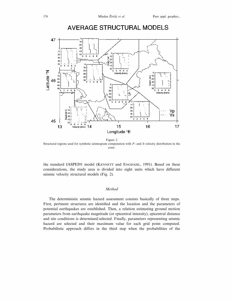
The structural regionalization of Slovenia is based primarily on surface wavedata (BONDAR et al., 1996; Z& IVCIC et al., this issue; COSTA et al., 1993) and on atomographic inversion of longitudinal waves (MICHELINI et al., 1998). Both thesemodels describe only layers in the upper crust. The depth of the crust is taken fromthe maps of the depth of the Mohorovicic discontinuity (RAVNIK et al., 1995 andreferences therein) while the upper mantle structure is assumed to be the same as in
Mladen Z& ivcic et al.176 Pure appl. geophys.,
Figure 2Structural regions used for synthetic seismogram computation with P- and S-velocity distribution in the
crust.
the standard IASPEI91 model (KENNETT and ENGDAHL, 1991). Based on theseconsiderations, the study area is divided into eight units which have differentseismic velocity structural models (Fig. 2).
Method
The deterministic seismic hazard assessment consists basically of three steps.First, pertinent structures are identified and the location and the parameters ofpotential earthquakes are established. Then, a relation estimating ground motionparameters from earthquake magnitude (or epicentral intensity), epicentral distanceand site conditions is determined/selected. Finally, parameters representing seismichazard are selected and their maximum value for each grid point computed.Probabilistic approach differs in the third step when the probabilities of the
Deterministic Seismic Hazard in Slovenia 177Vol. 157, 2000
exceedance are computed rather than maximum values. In our deterministic pro-cedure, fully described in COSTA et al. (1993), the second step is replaced bynumerical calculation of complete synthetic seismograms given the sourceparameters, distance and earth structural model. In this paper we have selectedthe maximum historical earthquake observed in a seismogenic zone as the maxi-mum possible event for that zone.
The territory under investigation is divided into eight polygons and to eachof them a uniform velocity structural model is assigned. At this stage only abedrock type of structure is considered and surface layers with S-wave velocitieslower then 1 km/s are not included. The same territory is divided in terms of theseismotectonic characteristics into seven seismogenic zones, and to each of thema characteristic focal mechanism is assigned. The delineation of seismogeniczones is based on the geodynamic model proposed by POLJAK et al. (2000), faultplane solutions and seismicity distribution. Outside Slovenia seismogenic zoneswere extended only to distances from which they can considerably influenceseismic hazard estimates on the territory of Slovenia.
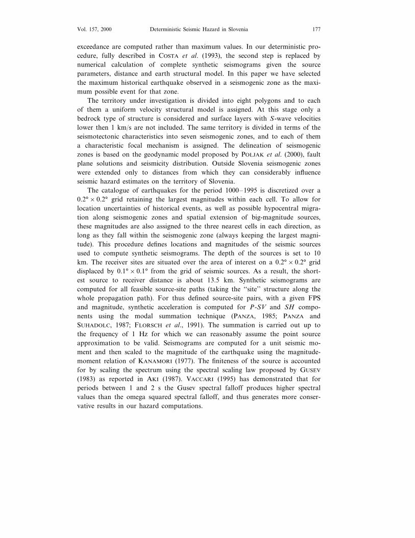
The catalogue of earthquakes for the period 1000–1995 is discretized over a0.2°×0.2° grid retaining the largest magnitudes within each cell. To allow forlocation uncertainties of historical events, as well as possible hypocentral migra-tion along seismogenic zones and spatial extension of big-magnitude sources,these magnitudes are also assigned to the three nearest cells in each direction, aslong as they fall within the seismogenic zone (always keeping the largest magni-tude). This procedure defines locations and magnitudes of the seismic sourcesused to compute synthetic seismograms. The depth of the sources is set to 10km. The receiver sites are situated over the area of interest on a 0.2°×0.2° griddisplaced by 0.1°×0.1° from the grid of seismic sources. As a result, the short-est source to receiver distance is about 13.5 km. Synthetic seismograms arecomputed for all feasible source-site paths (taking the ‘‘site’’ structure along thewhole propagation path). For thus defined source-site pairs, with a given FPSand magnitude, synthetic acceleration is computed for P-SV and SH compo-nents using the modal summation technique (PANZA, 1985; PANZA andSUHADOLC, 1987; FLORSCH et al., 1991). The summation is carried out up tothe frequency of 1 Hz for which we can reasonably assume the point sourceapproximation to be valid. Seismograms are computed for a unit seismic mo-ment and then scaled to the magnitude of the earthquake using the magnitude-moment relation of KANAMORI (1977). The finiteness of the source is accountedfor by scaling the spectrum using the spectral scaling law proposed by GUSEV
(1983) as reported in AKI (1987). VACCARI (1995) has demonstrated that forperiods between 1 and 2 s the Gusev spectral falloff produces higher spectralvalues than the omega squared spectral falloff, and thus generates more conser-vative results in our hazard computations.
Mladen Z& ivcic et al.178 Pure appl. geophys.,
Results
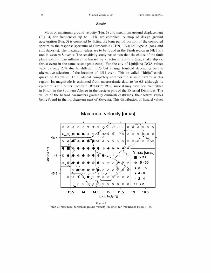
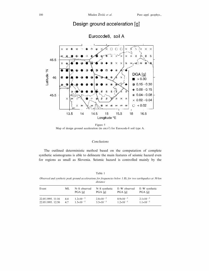
Maps of maximum ground velocity (Fig. 3) and maximum ground displacement(Fig. 4) for frequencies up to 1 Hz are compiled. A map of design groundacceleration (Fig. 5) is compiled by fitting the long period portion of the computedspectra to the response spectrum of Eurocode-8 (CEN, 1994) soil type A (rock andstiff deposits). The maximum values are to be found in the Friuli region in NE Italyand in western Slovenia. The sensitivity study has shown that the choice of the faultplane solution can influence the hazard by a factor of about 2 (e.g., strike slip vs.thrust event in the same seismogenic zone). For the city of Ljubljana DGA valuesvary by only 20% due to different FPS but change fourfold depending on thealternative selection of the location of 1511 event. This so called ‘‘Idrija’’ earth-quake of March 26, 1511, almost completely controls the seismic hazard in thisregion. Its magnitude is estimated from macroseismic data to be 6.8 although itsepicentre is still rather uncertain (RIBARIC, 1979) since it may have occurred eitherin Friuli, in the Southern Alps or in the western part of the External Dinarides. Thevalues of the hazard parameters gradually diminish eastwards, their lowest valuesbeing found in the northeastern part of Slovenia. This distribution of hazard values
Figure 3Map of maximum horizontal ground velocity (in cm/s) for frequencies below 1 Hz.
Deterministic Seismic Hazard in Slovenia 179Vol. 157, 2000
Figure 4Map of maximum horizontal ground displacement (in cm) for frequencies below 1 Hz.
is rather similar to the one based on intensity data (RIBARIC, 1986). However, thedifferent levels of seismic hazard between western and eastern Slovenia are morepronounced in our study and compare well with the deterministic studies for theneighbouring regions.
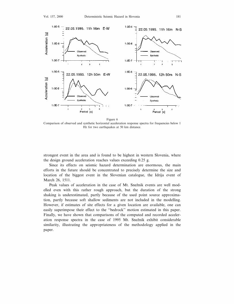
To evaluate the reliability of the applied method, we have compared syntheticswith the accelerograms of two earthquakes with epicentre in southern Sloveniarecorded on free field strong motion instrument in Ljubljana, 50 km north of theepicentre. The synthetics were computed using published fault plane solutions(HERAK et al., 1995) that are quite similar to the FPS proposed for this seismogeniczone. The values of the peak horizontal acceleration in the frequency band below1 Hz, for which theoretical computations have been made and hazard parametersare mapped, are given in Table 1.
The peak value of acceleration is predicted within a factor of two. Theacceleration response spectra for two events shown in Figure 6 match quite well theobserved ones up to periods of about 4 s. For longer periods the noise dominatesthe records and no comparison is possible.
Mladen Z& ivcic et al.180 Pure appl. geophys.,
Figure 5Map of design ground acceleration (in cm/s2) for Eurocode-8 soil type A.
Conclusions
The outlined deterministic method based on the computation of completesynthetic seismograms is able to delineate the main features of seismic hazard evenfor regions as small as Slovenia. Seismic hazard is controlled mainly by the
Table 1
Obser6ed and synthetic peak ground accelerations for frequencies below 1 Hz for two earthquakes at 50 kmdistance
Deterministic Seismic Hazard in Slovenia 181Vol. 157, 2000
Figure 6Comparison of observed and synthetic horizontal acceleration response spectra for frequencies below 1
Hz for two earthquakes at 50 km distance.
strongest event in the area and is found to be highest in western Slovenia, wherethe design ground acceleration reaches values exceeding 0.25 g.
Since its effects on seismic hazard determination are enormous, the mainefforts in the future should be concentrated to precisely determine the size andlocation of the biggest event in the Slovenian catalogue, the Idrija event ofMarch 26, 1511.
Peak values of acceleration in the case of Mt. Sneznik events are well mod-elled even with this rather rough approach, but the duration of the strongshaking is underestimated, partly because of the used point source approxima-tion, partly because soft shallow sediments are not included in the modelling.However, if estimates of site effects for a given location are available, one caneasily superimpose their effect to the ‘‘bedrock’’ motion estimated in this paper.Finally, we have shown that comparisons of the computed and recorded acceler-ation response spectra in the case of 1995 Mt. Sneznik exhibit considerablesimilarity, illustrating the appropriateness of the methodology applied in thepaper.
Mladen Z& ivcic et al.182 Pure appl. geophys.,
Acknowledgements
This work has been supported by EC Copernicus contract CIPA-CT94-0238.We have used GMT public domain graphics software for Figure 1 (WESSEL andSMITH, 1991). The authors are thankful to two anonymous referees for their carefulreview.
REFERENCES
AKI, K., Strong motion seismology. In Strong Ground Motion Seismology (eds. Erdik, M. O., andToksoz, M. N.) (NATO ASI Series C: Mathematical and Physical Sciences, D. Reidel PublishingCompany, Dordrecht, vol. 204, 1987) pp. 3–39.
BONDAR, I., BUS, Z., Z& IVCIC, M., COSTA, G., and LEVSHIN, A. (1996), Rayleigh Wa6e Group and PhaseVelocity Measurements in the Pannonian Basin, Proceedings, XV Congress of the Carpatho-BalcanGeological Association, Athens Sept. 17–20, 1995, 73–86.
BUBNOV, S., Potresi (Mladinska knjiga, Ljubljana 1996).CALCAGNILE, G., and PANZA, G. F. (1990), Crustal and Upper Mantle Structure of the Mediterranean
Area Deri6ed from Surface-wa6e Data, Phys. Earth Planet. Inter. 60, 163–168.CEN—EUROPEAN COMMITTEE FOR STANDARDIZATION (1994), Eurocode 8—Design Pro6isions for
Earthquake Resistance of Structures. Part 1-1: General Rules—Seismic Actions and General Require-ments for Structures, European Prestandard, ENV 1988-1-1.
CORNELL, C. A. (1968), Engineering Seismic Risk Analysis, Bull. Seismol. Soc. Am 58, 1583–1606.COSTA, G., PANZA, G. F., SUHADOLC, P., and VACCARI, F. (1993), Zoning of the Italian Territory in
Term of Expected Peak Ground Acceleration Deri6ed from Complete Synthetic Seismograms, J. Appl.Geophys. 30, 149–160.
CVIJANOVIC, D. (ed.) (1974), Map of distribution of maximum macroseismic intensities. In Proceedings ofthe Seminar of the Seismotectonic Map of the Balkan Region (eds. Karnik, V., and Gorskov, G. P.)UNESCO-UNDP Project REM/70/172, Skopje. Appendix: Maps.
CVIJANOVIC, D., Seizmicnost podrucja SR Hr6atske, Disertacija (Sveuciliste u Zagrebu, PMF, Zagreb1981).
FIEGWEIL, E. (1981), Austrian Earthquake Catalog (Computer File), Central Institute of Meteorologyand Geodynamics, Vienna.
FLORSCH, N., FAH, D., SUHADOLC, P., and PANZA, G. F. (1991), Complete Synthetic Seismograms forHigh-frequency Multimode Lo6e Wa6es, Pure appl. geophys. 136, 529–560.
FRANKEL, A. (1995), Mapping Seismic Hazard in the Central and Eastern United States, Seismol. Res.Lett. 66 (4), 8–21.
GUSEV, A. A. (1983), Descripti6e Statistical Model of Earthquake Source Radiation and its Application toan Estimation of Short Period Strong Motion, Geophys. J. R. Astron. Soc. 74, 787–808.
HERAK, M., HERAK, D., and MARKUSIC, S. (1995), Fault Plane Solutions for Earthquakes (1956–1995)in Croatia and Neighbouring Regions, Geofizika 12, 43–56.
ISC (1976), Bulletin of the International Seismological Centre, May 1976.JOKSOVIC, P., and ANDRIC, B., Ispiti6anje grad) e zemljine kore metodom dubokog seizmickog sondiranja
na profilu Pula—Maribor (Geofizika, Zagreb 1983) 33 pp. (in Croatian, unpublished).KANAMORI, H. (1977), The Energy Release in Great Earthquakes, J. Geophys. Res. 82, 2981–2987.KARNIK, V. (1968), Seismicity of the European Area, Part 1, Academia, Czechoslovak Academy of
Sciences, Praha.KARNIK, V. (1971), Seismicity of the European Area, Part 2, Academia, Czechoslovak Academy of
Sciences, Praha.KENNETT, B. L. N., and ENGDAHL, E. R. (1991), Tra6el Times for Global Earthquake Location and
Phase Identification, Geophys. J. Int. 105, 429–466.
Deterministic Seismic Hazard in Slovenia 183Vol. 157, 2000
KRINITZSKY, E. L. (1995), Deterministic Versus Probabilistic Seismic Hazard Analysis for CriticalStructures, Eng. Geol. 40, 1–7.
LAPAJNE, J. K., S& KET MOTNIKAR, B., ZABUKOVEC, B., and ZUPANCIC, P. (1997a), Spatially SmoothedSeismicity Modeling of Seismic Hazard in Slo6enia, J. Seismol. 1, 73–85.
LAPAJNE, J. K., S& KET MOTNIKAR, B., and ZUPANCIC, P. (1997b), Preliminary Seismic Hazard Maps ofSlo6enia, Natural Hazards 14, 155–164.
LAPAJNE, J. K., S& KET MOTNIKAR, B., and ZUPANCIC, P. (1995), Delineation of Seismic Hazard Areas inSlo6enia, Proceedings of the Fifth International Conference on Seismic Zonation, Nica 429, 436.
MICHELINI, A., Z& IVCIC, M., and SUHADOLC, P. (1998), Simultaneous In6ersion for Velocity Structure andHypocenters in Slo6enia, J. Seismol. 2, 257–265.
NESTEROV, A. N., and YANOVSKAYA, T. B. (1988), Lateral Lithosphere Inhomogeneities in SoutheasternEurope from Surface Wa6e Obser6ations, Izv. AN SSR, Fizika Zemli, 11, 3–15 (in Russian).
NESTEROV, A. N. and YANOVSKAYA, T. B. (1991) Inferences on Lithospheric Structure in SoutheasternEurope from Surface Wa6e Obser6ations, XXII General Assembly ESC, Proceedings and ActivityReport 1988–1990, I, 93–98.
OSSERVATORIO GEOFISICO SPERIMENTALE, OGS (1992), ALPOR-Earthquake Catalogue for the EasternAlps Region (Computer File), Trieste.
PANZA, G. F., MUELLER, ST., and CALCAGNILE, G. (1980), The Gross Features of the Lithosphere-asthenosphere System in Europe from Seismic Surface Wa6es and Body Wa6es, Pure appl. geophys.118, 1209–1213.
PANZA, G. F. (1985), Synthetic Seismograms: The Rayleigh Wa6es Modal Summation, J. Geophysics 58,125–145.
PANZA, G. F., and SUHADOLC, P., Complete strong motion synthetics. In Seismic Strong MotionSynthetics, Computational Techniques 4 (ed. Bolt, B. A.) (Academic Press, Orlando 1987) pp.153–204.
PANZA, G. F., VACCARI, F., COSTA, G., SUHADOLC, P., and FAEH, D. (1996), Seismic Input Modellingfor Zoning and Microzoning, Earthquake Spectra 12, 529–566.
POLJAK, M., Z& IVCIC, M., and ZUPANCIC, P. (2000) Seismotectonic Characteristics of Slo6enia, Pure appl.geophys. 157, 37–55.
RAVNIK, D., RAJVER, D., POLJAK, M., and Z& IVCIC, M. (1995), O6er6iew of the Geothermal Field ofSlo6enia in the Area between the Alps, the Dinarides and the Pannonian Basin, Tectonophysics 250,135–149.
RIBARIC, V. (1979), The Idrija Earthquake of March 26, 1511, Tectonophysics 53, 315–324.RIBARIC, V. (1982), Seismicity of Slo6enia—Catalogue of Earthquakes (792 A.D.-1981), SZ SRS,
Publication, Series A, 1-1, Ljubljana, 650 pp.RIBARIC, V. (1986), Prilozi prouca6anju seizmicnosti i seizmickog zoniranja Slo6enije, Disertacija,
Prirodoslovno-matematicki fakultet Sveucilista u Zagrebu, 337 pp.SHEBALIN, N. V., KARNIK, V., and HADZIEVSKI, D. (eds.) (1974), Catalogue of Earthquakes. Part I
1901–1970; Part II prior to 1901, UNDP/UNESCO Survey of the Seismicity of the Balkan Region.Skopje, 1–65 and Appendix.
SLEJKO, D., and KIJKO, A. (1991), Seismic Hazard Assessment for the Main Seismogenic Zones in theEastern Alps, Tectonophysics 191, 165–183.
SUHADOLC, P., and PANZA, G. F., Physical properties of the lithosphere-astenosphere system in Europefrom geophysical data. In The Lithosphere in Italy, Ad6ances in Earth Science Research (eds. Boriani,A., Bonafede, M., Piccardo, G. B., and Vai, G. B.) (Acad. Naz. Lincei 1989) pp. 15–44.
VACCARI, F. (1995), LP-displacement hazard e6aluation in Italy. In Proc. 24th General Assembly of theEuropean Seismological Commission, Athens, 3, 1489–1498.
WESSEL, P., and SMITH, W. H. F. (1991), Free Software Helps Map and Display Data, EOS, Trans.Amer. Geophys. Un. 72 (441), 445–446.
WILLMORE, P. L. (ed.) (1979), Manual of Seismological Obser6atory Practice, World Data Center A forSolid Earth Geophysics, Report SE-20.
ZAJEDNICA ZA SEIZMOLOGIJU SFRJ (1987), Tumac seizmoloske karte SFR Jugosla6ije, Beograd, 1987, 6pp.
Mladen Z& ivcic et al.184 Pure appl. geophys.,
ZSIROS, T., MONUS, P., and TOTH, L. (1988), Hungarian Earthquake Catalog (456–1986), SeismologicalObservatory, Geodetic and Geophysical Research Institute, Hungarian Academy of Sciences, Bu-dapest, 182 pp., Computer file (1992)—data from 456 to 1990.
Z& IVCIC, M., BONDAR, I., and PANZA, G. F. (2000), Upper Crustal Velocity Structure in Slo6enia fromRayleigh Wa6e Dispersion, Pure appl. geophys. 157, 131–146.
(Received May 25, 1998, revised October 8, 1998, accepted October 8, 1998)