ISRIC Working Paper and Preprint 95/10b A HOMOGENIZED SOIL DATA FILE FOR GLOBAL ENVIRONMENTAL RESEARCH: A SUBSET OF FAO, ISRIC AND NRCS PROFILES (Version 1.0) N.H. Batjes (Editor) July 1995 INTERNATIONAL SOIL REFERENCE AND INFORMATION CENTRE
Transcript
ISRIC
Working Paper and Preprint 95/10b
A HOMOGENIZED SOIL DATA FILE FOR GLOBAL ENVIRONMENTAL RESEARCH: A SUBSET OF FAO, ISRIC AND NRCS PROFILES
(Version 1.0)
N.H. Batjes (Editor)
July 1995
INTERNATIONAL SOIL REFERENCE AND INFORMATION CENTRE
All rights reserved. No part of this publication may be reproduced, stored in a retrieval system, ortransmitted in any form or by any means, electronic, mechanical, photocopying or otherwise, without theprior permission of the copyright owner. Applications for such permission, with a statement of the purposeand extent of the reproduction, should be addressed to the Director, ISRIC, P.O. Box 353, 6700 AJWageningen, The Netherlands.
While every effort has been made to ensure that the data are accurate and reliable, ISRIC cannot assumeliability for damages caused by in-accuracies in the data or as a result of the failure of the data to functionon a particular system. ISRIC provides no warranty, expressed or implied, nor does an authorizeddistribution of the data set constitute such a warranty. ISRIC reserves the right to modify any informationin this document and related data sets without notice.
Correct citation:Batjes, N.H. (ed.), 1995. A homogenized soil data file for global environmental research: a subset of FAO, ISRIC
and NRCS profiles (Version 1.0). Working Paper and Preprint 95/10b, International Soil Reference andInformation Centre, Wageningen.
List of FiguresFig. 1. Main database files of the WISE data handling system (2)
List of TablesTable 1. List of attribute data held in WISE (4)Table 2. Summary of number of profiles per broad geographic area (6)
AppendicesAppendix 1. Number of profiles per country in “international”data set (9)Appendix 2. Soil units represented in "international" data set (10)Appendix 3. Examples of listings of SDB, ISIS and NRCS profiles (11)Appendix 4. Brief installation procedure (17)Appendix 5. Structure and attributes of WISE database files (18)Appendix 6. WISE 2.1 database coding protocols (25)Appendix 7. List of country ISO codes (41)
INTERNATIONAL SOIL PROFILE DATA SET
ISRIC Work. Pap. 95/10b 1
AbstractA homogenized, global set of 1,125 soil profiles is presented. These profiles have been
extracted from the database developed at ISRIC for a project on "World Inventory of
Soil Emission Potentials" (WISE), as a contribution to the activities of the Global Soils
Data Task Group of IGBP-DIS. The subset consists of a selection of 665 profiles
originating from digital data files released by the Natural Resources Conservation
Service (NRCS, Lincoln), 250 profiles obtained from the Food and Agriculture
Organization (FAO, Rome), and 210 profiles from the reference collection of the
International Soil Reference and Information Centre (ISRIC, Wageningen). All profiles
are georeferenced and classified in the FAO-Unesco Legend whereby they can be linked
to the edited and digital version of the FAO-Unesco Soil Map of the World. This data
set is being released in the public domain for use by global modellers and other
interested scientists. It is envisaged that the data set will be expanded by ISRIC when
new, uniform soil profile data become available.
Keywords: soil profiles; WISE database
1. Introduction
The compilation and processing of large-scale data sets of the world's environmental
resources, using well-documented procedures and standards, is crucial for many global
modelling activities (e.g., Zuidema et al., 1994). Staff at ISRIC have developed a
uniform methodology for a global database of soil properties within the framework of
WISE, a project on World Inventory of Soil Emission Potentials (Batjes and Bridges,
1994). During this project a wide range of profiles from all regions of the world have
been screened for completeness and incorporated into the WISE data handling system.
The profiles in WISE were compiled from 5 main sources: (a) ISRIC's Soil Information
System, ISIS (Van de Ven and Tempel, 1994); (b) FAO's Soil Database System, SDB
(FAO, 1989); (c) digital soil data set compiled by the Natural Resources Conservation
Service (NRCS, formerly SCS) of the United States of America; (d) profiles obtained
from an international data gathering activity coordinated by WISE project staff, in
which national soil survey organisations were asked to supply descriptions and analyses
of profiles representative of the units of the Soil Map of the World present in their
countries; and, (e) suitable profiles gathered from survey monographs held at ISRIC's
library. Special attention was given to the systematic compilation of data and recording
of the laboratory methods by which the analytical results were obtained. All profiles are
classified in the FAO-Unesco (1974) legend, whereby they can be linked to the spatial
data shown on an edited and digital version of the Soil Map of the World (FAO, 1991).
INTERNATIONAL SOIL PROFILE DATA SET
2 ISRIC Work. Pap. 95/10b
SITE data HORIZON data
Code definitionconversion tables
1:M
AREA DATA ATTRIBUTE DATA
SMW soil units
Lab. methods Source
M:1
derived soildata per layer
G I S <- - -> W I S E profile data
This report describes a uniform set of 1,125 soil profiles, extracted from the WISE
database, for use by global modellers. The selected profiles correspond with what has
become known as the "international" profiles of the WISE database, and formed an
ISRIC contribution to the activities of the Global Soils Data Task Group of IGBP-DIS
(Scholes et al., 1994). The set includes 665 profiles from the USDA-NRCS, 250 from
the FAO-SDB and 210 from the ISRIC-ISIS databases.
Section 2 of this report describes the procedures for compiling and extracting the data
set, and possible user groups are identified in Section 3. Appendix 1 is a listing of the
countries from which the profiles originate. The FAO-Unesco (1974) classification of
these profiles is listed in Appendix 2. Examples of listings of profiles derived from these
data files are attached as Appendix 3, and the installation procedure is explained in
Appendix 4. Appendix 5 presents the structure and attributes of the WISE database,
Appendix 6 presents the database coding protocols and, finally, the country ISO codes
are given in Appendix 7.
Fig. 1. Main database files of the WISE data handling system (M:1 stands for many to one
relations, and 1:M for one to many relations)
INTERNATIONAL SOIL PROFILE DATA SET
ISRIC Work. Pap. 95/10b 3
2. Procedures
2.1 The WISE database
WISE 2.1 is a soil data handling system developed for IBM®-compatible computers.
It includes a collection of over 90 compiled program modules for storing, editing,
selecting and printing soil data. The individual modules for handling the soil profile
data are linked in a user-friendly manner by a unified menu system (Fig. 1) .
All procedures are written in dBASE IV®, as are the structures for the database files
(Batjes, 1995). The full WISE database holds a growing selection of globally
distributed profiles considered to be representative of the soil units shown on a ½Elatitude by ½E longitude version of the corrected and digitized 1:5 M FAO-Unesco Soil
Map of the World.
2.2 List of soil attributes
The profile component of the WISE database includes information on: (a) soil
classification and site data; (b) soil horizon data; (c) source of data; (d) the methods
used for determining the analytical data; and, (e) a series of "code-definition" translation
files (Batjes, 1995). The full complement of data selected for inclusion in the WISE
profile database is listed in Table 1. The attributes shown are similar to those proposed
for the European Soil Analytical Database (Madsen and Jones, 1995) and for a Global
Soils Database to be developed under the aegis of IGBP-DIS (Ingram, 1993). The
central aim of the WISE database is to provide a basic set of uniform soil data for a
wide range of global studies, including assessments of crop production, soil
vulnerability to pollution and soil gaseous emission potentials (Batjes et al., 1995).
2.3 Data sources and description methods
The "international" data set holds profiles released by ISRIC-ISIS, FAO-SDB and
USDA-NRCS. The profiles originating from ISIS have been compiled specifically to
be representative of the map units of the Soil Map of the World, with special emphasis
on the tropics. They have all been described using the Guidelines for Soil Description
(FAO-ISRIC, 1990) and analysed in a uniform manner in the ISRIC laboratory (Van
Reeuwijk, 1992). The profiles derived from the NRCS set originate from the USA and
41 other countries. Soil descriptions in this data set follow the methodology of the Soil
Survey Manual (USDA, 1993), and the analyses have been
INTERNATIONAL SOIL PROFILE DATA SET
4 ISRIC Work. Pap. 95/10b
Table 1. List of attribute data held in WISE.
Site Data Horizon Data
WISE_ID (unique identifier of profile)
Soil classification and sourceFAO-Unesco classification (1974 legend)
stone and gravel contentbulk density volume per cent water held at specified suctionshydraulic conductivity at specified suctions
WISE, World Inventory of Soil Emission Potentials; * Analytical methods are specified in aseparate key-attribute file.
INTERNATIONAL SOIL PROFILE DATA SET
ISRIC Work. Pap. 95/10b 5
made at the Lincoln laboratory (USDA, 1984). These analytical methods compare well
with those used at ISRIC (Kimble and Van Reeuwijk, pers. comm., 1994). Whereas
profiles originating from the SDB database (FAO, 1989) have been described using the
same guidelines which ISRIC used, the chemical and physical analyses have taken place
in different laboratories (FAO-Unesco, 1971-1981). Therefore, it is not always possible
to compare all SDB data sets directly with those of NRCS and ISIS (see Vogel, 1994).
2.4 Criteria for accepting profile data
Strict criteria have been defined for accepting profiles into WISE: (a) completeness and
apparent reliability of data; (b) traceability of source of data; (c) classifiable in the
FAO-Unesco (1974) legend; and (d) geo-referenced within defined limits. Profiles from
the "international" data holders have been off-loaded to WISE using an automated data-
transfer facility (Tempel, 1994). Procedures, called map-files, have been developed for
the transfer of data from the NRCS, SDB and ISIS databases to WISE 2.1
(Zunnenberg, unpublished data, 1994). Following the initial transfer to a WISE-
compatible dBASE® format, the integrity of the transferred data was checked by a
second computer module. It is only after this second operation that the "screened" data
sets were appended to the main WISE database files. Inherently, the use of an
automated transfer facility will encompass some loss of information (Tempel, 1994).
The original reference number of a soil profile is documented in the WISE database
files. In all cases, the source of data and laboratory where the analyses have been
carried out are specified (see Appendix 3). The WISE attribute-definition files which
are provided with the "international" data set should never be tampered with in any
way, because this will affect the integrity of the database.
2.5 Selection of "international" profiles
An extraction module was written for the mechanical extraction of the "international"
profiles stored in the WISE database. The selected profiles are from various regions of
the globe, with few profiles originating from Europe (Table 2). A data set of European
profiles is being compiled in a separate activity by the European Union (Madsen and
Jones, 1995), but so far unresolved copyright matters seem to have hindered its release
to third parties.
INTERNATIONAL SOIL PROFILE DATA SET
6 ISRIC Work. Pap. 95/10b
Table 2. Summary of number of profiles per broad geographic area (total= 1,125) WISE area Total Africa 315Australia and Pacific Islands 56China, India, Indonesia & Philippines 280Europe 7North America 158South America and Caribbean 241South west and Northern Asia (Siberia) 68
Appendix 1 lists the countries from where the soil profiles originate. The classificationof these soils is presented in Appendix 2. All profiles from the NRCS data set havebeen classified at ISRIC into the original (FAO-Unesco, 1974) and revised (FAO,1990a) legend (see Spaargaren and Batjes, 1995). About 94 % of the 1,125 profiles areclassified in the Revised Legend (FAO, 1990a) and about 88 % according to SoilTaxonomy (Soil Survey Staff, 1994 and earlier versions).
2.6 Sources of uncertainty
Initial printouts obtained from the NRCS, SDB and ISIS data sets after transfer intoWISE sometimes contained distorted soil horizon designations and duplicate horizondepths. This was partly associated with the fact that soil horizon and sample depthswere not always defined unambiguously in the source data files. Whenever possible,these "data issues" have been remedied manually with reference to the original data sets.
Differences in versions of USDA Soil Taxonomy used in the NRCS source files formeda difficulty when classifying profiles according to the FAO Legend. Similarly, differenthorizon designations are used in the various "international" data sets.
In some cases, profiles held in the source data files differed from those publishedelsewhere for the same profiles. This was the case for some NRCS profiles from Brazil,Korea and Zambia (see Spaargaren and Batjes, 1995), some SDB profiles fromBotswana (see FAO, 1990b), and some ISIS profiles. This aspect illustrates thedifficulty in preserving data integrity in digital files since their contents can easily becorrupted. In most cases, data sets obtained from NRCS, SDB and ISIS were taken at"face value" in view of the fact that they have been officially released for inclusion inthe WISE database. Nonetheless, all transferred data sets have been submitted toWISE's computerized and rigorous data-checking scheme leading to rejection of someof the profiles (see Section 2.4).
In case of missing latitude-longitude references, approximate coordinates have beenderived from the Times Atlas (1993), using general information on location (e.g.,Machakos, Kenya).
INTERNATIONAL SOIL PROFILE DATA SET
ISRIC Work. Pap. 95/10b 7
3. Discussion and conclusions
Version 1.0 of the "international" data set is being released with the implicitunderstanding that the source will be acknowledged in all publications arising from useof the data. The "international" data set is particularly meant for those scientists whowish to study "primary" soil data. Files are presented in dBASE® IV format using theWISE database structure and coding conventions (see Batjes, 1995).
The "international" data sets held in WISE have been proposed to serve as the nucleusfor a global profile data set to be developed by the Global Soil Data Task Group ofIGBP-DIS (Scholes et al., 1994). The data set discussed in this paper, with a selectionof soil profiles from three major international holders of soil data — NRCS, FAO andISRIC —, is to provide the initial soil profile data for this collaborative activity.
It is anticipated that new releases of the "international" data set will be prepared as newprofile data are being added to the WISE database, notably about 400 profiles fromISRIC's project on National Soil Reference and Database Collections (NASREC).
The WISE database proper, which currently contains over 4,300 profiles, is being usedby ISRIC to generate a series of uniform data sets of derived soil properties, linked toa ½E longitude by ½E latitude version of the edited and digital Soil Map of the World(FAO, 1991), for subsequent use by global modellers.
AcknowledgementsAs with any collaborative activity, the WISE project has been carried out with the help ofmany people. The data held in the current "international" data set have been obtained fromvarious organisations including: (a) the Natural Resources Conservation Service (USDA-NRCS, formerly SCS) at Lincoln, and J.M. Kimble in particular; (b) FAO's Land and WaterDevelopment Division (AGL), notably F.O. Nachtergaele; and (c) ISRIC, particularly J.H.Kauffman co-ordinator of the NASREC/ISIS project. Crucial, auxiliary software for thedigital transfer of data obtained from these organisations to the WISE database structure wasdeveloped and tested at ISRIC by P. Tempel. The accompanying "map files" were elaboratedby W. Zunnenberg. All profiles transferred from the NRCS data tape have been checked andclassified in the FAO-Unesco system by O.C. Spaargaren under a subcontract with IGBP-DIS.All profiles derived from ISIS were manually checked by E.M. Bridges. Constructivecomments on creating the "international" data set were received from W.V.P. van Engelenand L.R. Oldeman. The contributions of ISRIC's staff in the WISE project activities, and thoseof E.M. Bridges in particular, are gratefully acknowledged.
The WISE data handling system has been developed at ISRIC for a project on theGeographic Quantification of Soil Factors and Processes that Control Fluxes of GreenhouseGases —known as World Inventory of Soil Emission Potentials (WISE)— with sponsorshipfrom the Netherlands National Research Programme on Global Air Pollution and ClimateChange (Project 851039).
References
Batjes, N. H., 1995. World Inventory of Soil Emission Potentials: WISE 2.1 - ProfileDatabase User Manual and Coding Protocols. Technical Paper 26, ISRIC, Wageningen.
INTERNATIONAL SOIL PROFILE DATA SET
8 ISRIC Work. Pap. 95/10b
Batjes, N. H. and E. M. Bridges, 1994. Potential Emissions of Radiatively Active Gases fromSoil to Atmosphere with Special Reference to Methane: Development of a Global Database(WISE). J. Geophys. Res. 99(D8): 16,479-16,489.
Batjes, N. H., E. M. Bridges and F. O. Nachtergaele, 1995. World Inventory of Soil EmissionPotentials: Development of a Global Soil Database of Process Controlling Factors. In:Climate Change and Rice (Editors S. Peng et al. ), Springer-Verlag, Heidelberg, pp. 102-115.
FAO, 1991. Digitized Soil Map of the World. World Soil Resources Report 67, FAO, Rome.FAO-Unesco, 1974. Soil Map of the World. Volume I: Legend. Unesco, Paris.FAO, 1990a. FAO-Unesco Soil Map of the World: Revised Legend. World Soil Resources
Report 60, FAO, Rome [Reprinted as Technical Paper 20, ISRIC, Wageningen, 1994].FAO, 1990b. Explanatory note on the Soil Map of the Republic of Botswana. AG-
BOT/85/011, FAO, UNDP and Republic of Botswana, Gaborone.FAO-ISRIC, 1990. Guidelines for Soil Description. FAO, Rome.Ingram, J. S. I. (ed.), 1993. IGBP-DIS & GCTE Global Soils Database Workshop. Meeting
held at the Soil Survey and Land Research Centre, Silsoe (8-9 October 1992), IGBP-DISWorking Paper 7, Paris.
Madsen, H. B. and R.J.A. Jones, 1995. The establishment of a soil profile analytical databasefor the European Union. In European Land Information Systems for Agro-environmentalMonitoring (Editors D. King, R.J.A. Jones and A.J. Thomasson), Office for OfficialPublications of the European Communities, Luxembourg, pp. 55-63.
Scholes, R. J., D. Skole and J. S. Ingram, 1994. A Global Database of Soil Properties:Proposal for Implementation. IGBP-DIS Working Paper 10, International GeosphereBiosphere Program, Data and Information System, Paris.
Soil Survey Staff, 1993. Soil Survey Manual (revised and enlarged edition). United StatesDepartment of Agriculture, Handbook No. 18, Washington D.C.
Soil Survey Staff, 1994. Keys to Soil Taxonomy (Sixth Edition). United States Department ofAgriculture, Soil Conservation Service, Washington D.C.
Spaargaren, O.C. and N.H. Batjes, 1995. Report on the classification into FAO-Unesco SoilUnits of Profiles Selected from the NRCS Pedon Database for IGBP-DIS. Working Paperand Preprint 95/01, ISRIC, Wageningen.
Tempel, P., 1994. Data Transfer Facility between Disparate Soil Databases. Working Paperand Preprint 94/08, International Soil Reference and Information Centre, Wageningen.
Times Atlas, 1993. The Times Atlas of the World. Times Books, Harper Collins Publ.,London.
Van de Ven, T. and P. Tempel, 1994. ISIS 4.0 - ISRIC Soil Information System: UserManual. Technical Paper 15 (rev. ed.), International Soil Reference and InformationCentre, Wageningen.
Van Reeuwijk, L. P., 1992. Procedures for Soil Analysis (Third ed.). Technical Paper 19,International Soil Reference and Information Centre, Wageningen.
Zuidema, G., G.J. van den Born, J. Alcamo and G.J.J. Kreileman, 1994. Simulation of globalland cover changes as affected by economic factors and climate. Water, Air and SoilPollution, 76: 163-198.
INTERNATIONAL SOIL PROFILE DATA SET
ISRIC Work. Pap. 95/10b 9
Appendices
Appendix 1. Number of profiles per country in “international”data set.
Country TotalAR - Argentina 5AU - Australia 15BD - Bangladesh 3BE - Belgium 1BF - Burkina Faso 1BI - Burundi 12BR - Brazil 69BW - Botswana 33CA - Canada 2CI - Cote d'Ivoire 12CK - Cook Islands 1CL - Chile 6CM - Cameroon 34CN - China 50CO - Colombia 27CR - Costa Rica 28CU - Cuba 21DE - Germany, Fed. Rep. of 1DZ - Algeria 4EC - Ecuador 16FI - Finland 1GN - Guinea 1GT - Guatemala 11GY - Guyana 3HN - Honduras 8ID - Indonesia 58IN - India 49IT - Italy 1JO - Jordan 14JP - Japan 4KE - Kenya 32KR - Korea, Republic of 15LB - Lebanon 2LS - Lesotho 15MA - Morocco 5
Country Total ML - Mali 14MX - Mexico 4MY - Malaysia 2MZ - Mozambique 1NC - New Caledonia 1NE - Niger 11NG - Nigeria 1NI - Nicaragua 21NP - Nepal 5NZ - New Zealand 5PA - Panama 14PG - Papua New Guinea 16PH - Philippines 42PK - Pakistan 37 PR - Puerto Rico 1RO - Romania 1RW - Rwanda 6SB - Solomon Islands 1SD - Sudan 46SL - Sierra Leone 1SN - Senegal 2SV - El Salvador 5SY - Syrian Arab Republic 6 TH - Thailand 35TN - Tunisia 15TO - Tonga 2TW - Taiwan 0 UG - Uganda 12US - United States 154VE - Venezuela 6WS - Samoa 14YE - Yemen 26ZA - South Africa 4ZM - Zambia 37ZW - Zimbabwe 16
INTERNATIONAL SOIL PROFILE DATA SET
10 ISRIC Work. Pap. 95/10b
Appendix 2. Soil units represented in "international" data set (FAO-Unesco, 1974).
SITE DATA: Location: 9 Km SW Marilia, Sao Paulo state (Brazil) Coordinates: Lat.: S 22 deg. 19 min. -- sec. Lon.: W 050 deg. 00 min. -- sec. Altitude: 620 m Landform: -- (-) Position: -- (-) Aspect: - Slope: - % Drainage class: moderately well drained (M) Groundwater: -1 to -1 (cm) Eff. soil depth > -1 (cm) Parent material: sandstone, greywacke, arkose (SC2) (Remarks: -) Koppen climate: Equat. humid with dry season in low-sun season (driest month <60;Tcm > 18C) (Aw) Land use (LU): -- (-) Main crop: coffee (CF) Vegetation (VE): -- (-) Remarks on LU/VE: -
--------------------------------------------------------------------------------------------------------------------------- Horiz. Colour M R ST Sand Silt Clay GR Bd % vol/vol moisture held at a pF of AWC HCs HCu -------------- (%) (%) (%) (%) ------------------------------------------- (%v/v) (cm/hr) Desig. Dry Moist 0.0 1.0 1.5 1.7 2.0 2.3 2.5 2.7 3.4 3.7 4.2 --------------------------------------------------------------------------------------------------------------------------- Ap - 5YR3/3 - M - 91 3 6 -1 -1.0 -1 -1 -1 -1 -1 -1 -1 -1 -1 -1 -1 -1 -1.0 -1.0 E - 5YR4/3 - M - 94 2 4 -1 -1.0 -1 -1 -1 -1 -1 -1 -1 -1 -1 -1 -1 -1 -1.0 -1.0 B1 - 2.5YR4/4 C M SB 73 2 25 -1 -1.0 -1 -1 -1 -1 -1 -1 -1 -1 -1 -1 -1 -1 -1.0 -1.0 B2 - 2.5YR3/6 F F - 74 2 24 -1 -1.0 -1 -1 -1 -1 -1 -1 -1 -1 -1 -1 -1 -1 -1.0 -1.0 BC - 5YR4/6 - F - 80 2 18 -1 -1.0 -1 -1 -1 -1 -1 -1 -1 -1 -1 -1 -1 -1 -1.0 -1.0 --------------------------------------------------------------------------------------------------------------------------- Abbr.: Av. P as mg P2O5/kg soil; ECx= electrical conductivity in dS/m; Ac= exchangeable (H + Al) in meq/100g; BS= base saturation (% of CEC); M= mottles; R= roots; ST= structure; GR = % > 2mm size; Bd= bulk density (g/cm3); HC= hydr. conduct., saturated (HCs) resp. unsat. (HCu) in cm/hr; AWC= av. moisture in v/v %; -1 stands for missing numeric values and - for missing alphanumeric values.
REMARKS: SDB-profile= BR011.
REFERENCES: a) Source of profile data [FAO/SDB-2]: Various authors (see relevant FAO reports), 1994. Selected soils from FAO's Soil Data Base (SDB; May 94); transfer map-files prepared by W. Zunnenberg. Data from FAO, Rome.
INTERNATIONAL SOIL PROFILE DATA SET
12 ISRIC Work. Pap. 95/10b
b) Laboratory name and methods [XX01]: General methods as described in FAO-Unesco Soil Map of the World. ------------------------------------------------------------------------------------------------------------------- Analytical method Code and description ------------------------------------------------------------------------------------------------------------------- Organic Carbon: OC01: Method of Walkley-Black (Org. matter = Org. C x 1.72) Total Nitrogen: TN01: Method of Kjeldahl Available P: TP99: Method not defined pH-H2O: PH02: pH 1:2.5 soil/water solution pH-KCl: PK02: pH in 1:2.5 soil/ M KCl solution pH-CaCl2: PC02: pH in 1:2.5 soil/1 M CaCl2 solution Electr. conductivity: EL04: Elec. conductivity in saturated paste (ECe) CaCO3 content: CA04: Calcimeter method (volumetric after adition of dilute acid) Gypsum content: GY01: Dissolved in water and precipitated by acetone Exch. Ca, Mg, Na and K: EX01: Various methods with no apparent differences in results Exch. acidity and aluminum: EA--: Not measured CEC soil: CS01: CEC in 1M NH4OAc buffered at pH 7 Effective CEC: CE--: Not measured Base saturation: BS01: Sum of bases as percentage of CEC (method specified above) Particle size analysis: TE01: Pipette method, with appropriate dispersion treatment (c< 0.002 <si< 0.05 <sa< 2mm) Bulkdensity: BD--: Not measured Soil moisture content: MC--: Not measured Hydraulic conductivity: HC--: Not measured ------------------------------------------------------------------------------------------------------------------
INTERNATIONAL SOIL PROFILE DATA SET
ISRIC Work. Pap. 95/10b 13
BR069 W I S E S O I L P R O F I L E D A T A S H E E T 21/06/95 ====================================================
--------------------------------------------------------------------------------------------------------------------------- Horiz. Colour M R ST Sand Silt Clay GR Bd % vol/vol moisture held at a pF of AWC HCs HCu -------------- (%) (%) (%) (%) ------------------------------------------- (%v/v) (cm/hr) Desig. Dry Moist 0.0 1.0 1.5 1.7 2.0 2.3 2.5 2.7 3.4 3.7 4.2 --------------------------------------------------------------------------------------------------------------------------- Ap 10YR6/2 10YR4/2 N MV SB 69 16 15 -1 -1.0 -1 -1 -1 -1 -1 -1 -1 -1 -1 -1 -1 -1 -1.0 -1.0 E1 10YR6/3 10YR5/4 N CV MA 64 15 21 -1 1.57 36 35 29 -1 23 21 -1 18 15 -1 14 15 -1.0 -1.0 E2 10YR6/3 10YR5/4 N VV MA 61 13 26 -1 -1.0 -1 -1 -1 -1 -1 -1 -1 -1 -1 -1 -1 -1 -1.0 -1.0 Bt1 5YR6/6 2.5YR4/6 N VV SB 28 12 60 -1 -1.0 -1 -1 -1 -1 -1 -1 -1 -1 -1 -1 -1 -1 -1.0 -1.0 Bt2 2.5YR6/6 2.5YR4/6 N VV SB 35 16 49 -1 1.43 43 41 38 -1 35 33 -1 32 30 -1 27 11 -1.0 -1.0 Bt3 5YR6/6 4YR4/6 N - SB 38 20 42 -1 -1.0 -1 -1 -1 -1 -1 -1 -1 -1 -1 -1 -1 -1 -1.0 -1.0 CB 7.5YR6/6 5YR4/6 N - MA 45 26 29 -1 1.54 41 40 38 -1 34 32 -1 30 24 -1 21 17 -1.0 -1.0 C - - - - - 55 26 19 -1 -1.0 -1 -1 -1 -1 -1 -1 -1 -1 -1 -1 -1 -1 -1.0 -1.0 --------------------------------------------------------------------------------------------------------------------------- Abbr.: Av. P as mg P2O5/kg soil; ECx= electrical conductivity in dS/m; Ac= exchangeable (H + Al) in meq/100g; BS= base saturation (% of CEC); M= mottles; R= roots; ST= structure; GR = % > 2mm size; Bd= bulk density (g/cm3); HC= hydr. conduct., saturated (HCs) resp. unsat. (HCu) in cm/hr; AWC= av. moisture in v/v %; -1 stands for missing numeric values and - for missing alphanumeric values.
REMARKS: A deep, moderately well drained, red clay soil derived from gneiss; having a yellowish brown, porous, sandy (clay) loam topsoil. The B horizons show coating of illuvial clay and limited permeability.
REFERENCES: a) Source of profile data [ISIS-0994]: Various authors (see relevant ISRIC Country Reports), 1994. ISIS data set of September 1994 (J.H. Kauffman); transfer map-file produced by W. Zunnenberg. See: Van de Ven, T. and P. Tempel, 1994. ISIS 4 - User Manual. Technical Paper 15, ISRIC, Wageningen.
INTERNATIONAL SOIL PROFILE DATA SET
14 ISRIC Work. Pap. 95/10b
b) Laboratory name and methods [NL01]: International Soil Reference and Information Centre (ISRIC) laboratory, Wageningen, The Netherlands. ------------------------------------------------------------------------------------------------------------------- Analytical method Code and description ------------------------------------------------------------------------------------------------------------------- Organic Carbon: OC01: Method of Walkley-Black (Org. matter = Org. C x 1.72) Total Nitrogen: TN01: Method of Kjeldahl Available P: TP18: Bray-I (acid soils) resp. Olsen (other soils) pH-H2O: PH02: pH 1:2.5 soil/water solution pH-KCl: PK02: pH in 1:2.5 soil/ M KCl solution pH-CaCl2: PC--: Not measured Electr. conductivity: EL04: Elec. conductivity in saturated paste (ECe) CaCO3 content: CA03: Method of Piper Gypsum content: GY01: Dissolved in water and precipitated by acetone Exch. Ca, Mg, Na and K: EX01: Various methods with no apparent differences in results Exch. acidity and aluminum: EA01: Exchangeable acidity (H+Al) in 1 M KCl CEC soil: CS01: CEC in 1M NH4OAc buffered at pH 7 Effective CEC: CE01: Sum of exch. Ca, Mg, K and Na, plus exchangeable aluminium (in 1M KCl) Base saturation: BS01: Sum of bases as percentage of CEC (method specified above) Particle size analysis: TE01: Pipette method, with appropriate dispersion treatment (c< 0.002 <si< 0.05 <sa< 2mm) Bulkdensity: BD01: Core sampling (pF rings) Soil moisture content: MC01: sand/silt baths and porous plates, undisturbed samples (pF rings) Hydraulic conductivity: HC--: Not measured -----------------------------------------------------------------------------------------------------------------
INTERNATIONAL SOIL PROFILE DATA SET
ISRIC Work. Pap. 95/10b 15
BR097 W I S E S O I L P R O F I L E D A T A S H E E T 21/06/95 ====================================================
---------------------------------------------------------------------------------------------------------------------------Horiz. Colour M R ST Sand Silt Clay GR Bd % vol/vol moisture held at a pF of AWC HCs HCu -------------- (%) (%) (%) (%) ------------------------------------------- (%v/v) (cm/hr) Desig. Dry Moist 0.0 1.0 1.5 1.7 2.0 2.3 2.5 2.7 3.4 3.7 4.2 ---------------------------------------------------------------------------------------------------------------------------Ap1 5YR3/3 5YR3/3 - CM GR 18 21 61 -1 -1.0 -1 -1 -1 -1 -1 -1 -1 -1 -1 -1 22 -1 -1.0 -1.0Ap2 5YR4/4 2.5YE3/6 - CM SB 17 16 67 -1 1.48 -1 -1 -1 -1 30 -1 29 -1 -1 -1 21 9 -1.0 -1.0Bto1 2.5YR5/6 2.5YR3/6 - CM SB 11 12 77 -1 1.39 -1 -1 -1 -1 33 -1 32 -1 -1 -1 25 8 -1.0 -1.0Bto2 2.5YR5/6 2.5YR4/6 - CM SB 11 13 76 -1 1.16 -1 -1 -1 -1 36 -1 34 -1 -1 -1 26 10 -1.0 -1.0Bo1 2.5YR4/6 2.5YR4/6 - F GR 12 15 73 -1 1.22 -1 -1 -1 -1 36 -1 33 -1 -1 -1 26 10 -1.0 -1.0Bo2 2.5YR5/6 10R4/6 - F - 15 23 62 -1 -1.0 -1 -1 -1 -1 -1 -1 -1 -1 -1 -1 26 -1 -1.0 -1.0BC 10YR5/6 10R5/6 - F - 14 34 52 -1 -1.0 -1 -1 -1 -1 -1 -1 -1 -1 -1 -1 27 -1 -1.0 -1.0--------------------------------------------------------------------------------------------------------------------------- Abbr.: Av. P as mg P2O5/kg soil; ECx= electrical conductivity in dS/m; Ac= exchangeable (H + Al) in meq/100g; BS= base saturation (% of CEC); M= mottles; R= roots; ST= structure; GR = % > 2mm size; Bd= bulk density (g/cm3); HC= hydr. conduct., saturated (HCs) resp. unsat. (HCu) in cm/hr; AWC= av. moisture in v/v %; -1 stands for missing numeric values and - for missing alphanumeric values.
REMARKS: None.
REFERENCES: a) Source of profile data [NRCS-USDA]: Soil Survey Staff (Dr J.M. Kimble; FAO class. by Dr O.C. Spaargaren), 1994. Collection of profiles derived from data-tape provided by SCS laboratory (now NRCS) at Lincoln, NE. Soil Taxonomy ('75, '90, '94)
INTERNATIONAL SOIL PROFILE DATA SET
16 ISRIC Work. Pap. 95/10b
b) Laboratory name and methods [US01]: Soil Conservation Service (now NRCS), Lincoln, Nebraska ------------------------------------------------------------------------------------------------------------------- Analytical method Code and description-------------------------------------------------------------------------------------------------------------------- Organic Carbon: OC01: Method of Walkley-Black (Org. matter = Org. C x 1.72) Total Nitrogen: TN01: Method of Kjeldahl Available P: TP18: Bray-I (acid soils) resp. Olsen (other soils) pH-H2O: PH02: pH 1:2.5 soil/water solution pH-KCl: PK02: pH in 1:2.5 soil/ M KCl solution pH-CaCl2: PC--: Not measured Electr. conductivity: EL04: Elec. conductivity in saturated paste (ECe) CaCO3 content: CA03: Method of Piper Gypsum content: GY01: Dissolved in water and precipitated by acetone Exch. Ca, Mg, Na and K: EX01: Various methods with no apparent differences in results Exch. acidity and aluminum: EA01: Exchangeable acidity (H+Al) in 1 M KCl CEC soil: CS01: CEC in 1M NH4OAc buffered at pH 7 Effective CEC: CE01: Sum of exch. Ca, Mg, K and Na, plus exchangeable aluminium (in 1M KCl) * Base saturation: BS01: Sum of bases as percentage of CEC (method specified above) Particle size analysis: TE01: Pipette method, with appropriate dispersion treatment (c< 0.002 <si< 0.05 <sa< 2mm) Bulkdensity: BD01: Core sampling (pF rings) Soil moisture content: MC01: sand/silt baths and porous plates, undisturbed samples (pF rings) Hydraulic conductivity: HC--: Not measured --------------------------------------------------------------------------------------------------------------------
INTERNATIONAL SOIL PROFILE DATA SET
ISRIC Work. Pap. 95/10b 17
Appendix 4. Brief installation procedure
Installing WISE
The “international profile data set” is distributed mainly as “e-mail attachments”. TheWISE 2.1 data handling system and "international profile data set" can be installed onIBM-compatible PC's (386 and up). The installation procedure must start from withinthe directory to which the installation files were transferred initially as e-mailattachments. The relevant files are WISSETUP.BAT and WISSETUP.ZIP. Ashareware copy of PKZIP#, which is necessary to decompress WISSETUP.ZIP, isattached also.
To install the data set and data handling system from the DOS prompt (or with RUNoption under WINDOWS) simply start in the directory where your e-mail files arrive(e.g. C:\E_MAIL): C:\E_MAIL> WISSETUP
WISSETUP.BAT first creates C:\WISE, with appropriate subdirectories, to which thevarious program, system and data files will be copied. In order to access the data acopy of the proprietary dBASE IV language, version 1.5 and up, is needed. Thedatafiles proper however, being dbf-files, can be accessed with a range of software.
Prior to accessing the data set, a PATH must be set to the directory where dBASE IVresides on the C-drive (C:\DB4), as well as a path to C:\WISE, by adding the followingstatements to the AUTOEXEC.BAT file on the C-drive, e.g.: PATH C:\; C:\DOS; .....; C:\DB4; C:\WISE; ..
The WISE data handling system was developed using dBASE IV, version 1.5. Pleasenote that if version 2.0 of dBASE IV is used, the file C:\DB4\CONFIG.DB must beedited to include the following line: LDCHECK = OFF
Once the above operations have been performed, the system must be re-booted so thatthe new path-configuration becomes operational.
At this stage the WISE 2.1 data handling system and "international profile data set" canbe accessed by entering: WISE
Full data base structure definitions, indexing conventions, and coding conventions maybe found in Appendix 5 to 7 (from Batjes, 1995).
INTERNATIONAL SOIL PROFILE DATA SET
18 ISRIC Work. Pap. 95/10b
Appendix 5. Structure and attributes of WISE database files
A) WISE database files
Structure for database: WISESITE.DBF
Field Name Type Width Dec Description
WISE_ID Character 5 Unique profile reference numberLAB_ID Character 4 Unique laboratory reference numberSOURCE_ID Character 10 Unique reference number for source of profile dataREFPAG Character 50 Profile/page reference in sourceHORNUM Numeric 1 Number of horizons described for pit (Y/N,
control variable)FAO_74 Character 2 FAO-Unesco (1974), classification as codePHA_74 Character 2 As above, but code for (main) phaseTOP_74 Character 1 As above, but code for topsoil textural classFAO_90 Character 3 FAO-Unesco (1990), classification as codePHA_90 Character 2 As above, but code for (main) phase USCL Character 50 USDA Soil Taxonomy classification, descriptiveUSYR Character 2 Year (version of Soil Taxonomy, e.g., 75, 94)LOCAL Character 50 Local classification, descriptiveDESCR Character 1 Profile description status, codeDATE Character 5 Date profile was first describedCOUN Character 2 ISO code for country of originLOCAT Character 50 Location of profile, descriptiveLATIT Character 1 Latitude of profile (N/S)LATDEG Character 2 degreesLATMIN Character 2 minutesLATSEC Character 2 secondsLONGI Character 1 Longitude of profile (E/W)LONDEG Character 3 degreesLONMIN Character 2 minutesLONSEC Character 2 secondsALTIT Numeric 4 Elevation (m)LFORM Character 2 Landform, code POSIT Character 2 Position, code ASPECT Character 3 Aspect, codeSLOPE Character 3 Slope at profile site (%)DRAIN Character 2 Drainage condition, codeGRWHI Numeric 4 Average, highest groundwater level (cm)GRWLO Numeric 4 Average, lowest groundwater level (cm)SOLDEP Numeric 4 Average, soil depth to a physically limiting layer (cm)PARMAT Character 3 Parent material, codePARREM Character 50 Remarks on parent material, descriptiveKOPPEN Character 3 Köppen climate classification, codeLANDUS Character 3 Land use, codeCROPS Character 2 Crops, codeVEGCOD Character 2 Vegetation, codeVEGREM Character 100 Remarks on either land use or vegetation, descriptiveREMARKS Character 5 Data entry source code
INTERNATIONAL SOIL PROFILE DATA SET
ISRIC Work. Pap. 95/10b 19
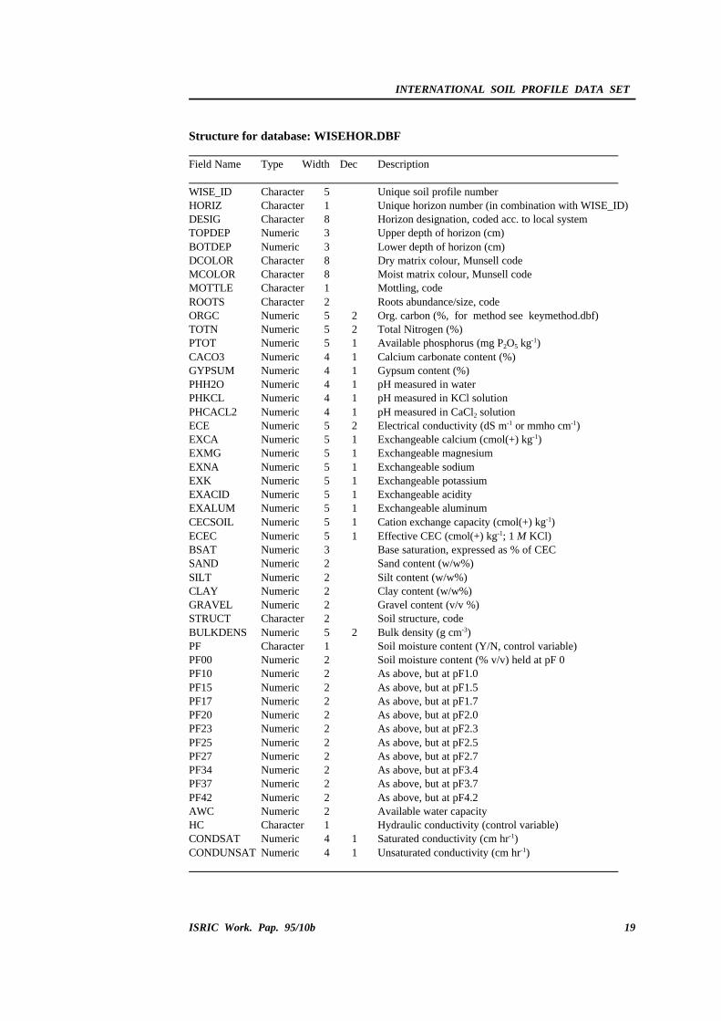
Structure for database: WISEHOR.DBF
Field Name Type Width Dec Description
WISE_ID Character 5 Unique soil profile numberHORIZ Character 1 Unique horizon number (in combination with WISE_ID)DESIG Character 8 Horizon designation, coded acc. to local systemTOPDEP Numeric 3 Upper depth of horizon (cm)BOTDEP Numeric 3 Lower depth of horizon (cm)DCOLOR Character 8 Dry matrix colour, Munsell codeMCOLOR Character 8 Moist matrix colour, Munsell code MOTTLE Character 1 Mottling, code ROOTS Character 2 Roots abundance/size, code ORGC Numeric 5 2 Org. carbon (%, for method see keymethod.dbf)TOTN Numeric 5 2 Total Nitrogen (%)PTOT Numeric 5 1 Available phosphorus (mg P2O5 kg-1)CACO3 Numeric 4 1 Calcium carbonate content (%)GYPSUM Numeric 4 1 Gypsum content (%)PHH2O Numeric 4 1 pH measured in waterPHKCL Numeric 4 1 pH measured in KCl solutionPHCACL2 Numeric 4 1 pH measured in CaCl2 solutionECE Numeric 5 2 Electrical conductivity (dS m-1 or mmho cm-1)EXCA Numeric 5 1 Exchangeable calcium (cmol(+) kg-1)EXMG Numeric 5 1 Exchangeable magnesium EXNA Numeric 5 1 Exchangeable sodiumEXK Numeric 5 1 Exchangeable potassium EXACID Numeric 5 1 Exchangeable acidityEXALUM Numeric 5 1 Exchangeable aluminumCECSOIL Numeric 5 1 Cation exchange capacity (cmol(+) kg-1)ECEC Numeric 5 1 Effective CEC (cmol(+) kg-1; 1 M KCl)BSAT Numeric 3 Base saturation, expressed as % of CECSAND Numeric 2 Sand content (w/w%)SILT Numeric 2 Silt content (w/w%)CLAY Numeric 2 Clay content (w/w%)GRAVEL Numeric 2 Gravel content (v/v %)STRUCT Character 2 Soil structure, codeBULKDENS Numeric 5 2 Bulk density (g cm-3)PF Character 1 Soil moisture content (Y/N, control variable) PF00 Numeric 2 Soil moisture content (% v/v) held at pF 0PF10 Numeric 2 As above, but at pF1.0PF15 Numeric 2 As above, but at pF1.5PF17 Numeric 2 As above, but at pF1.7PF20 Numeric 2 As above, but at pF2.0PF23 Numeric 2 As above, but at pF2.3PF25 Numeric 2 As above, but at pF2.5 PF27 Numeric 2 As above, but at pF2.7PF34 Numeric 2 As above, but at pF3.4PF37 Numeric 2 As above, but at pF3.7 PF42 Numeric 2 As above, but at pF4.2AWC Numeric 2 Available water capacity HC Character 1 Hydraulic conductivity (control variable)CONDSAT Numeric 4 1 Saturated conductivity (cm hr-1)CONDUNSAT Numeric 4 1 Unsaturated conductivity (cm hr-1)
INTERNATIONAL SOIL PROFILE DATA SET
20 ISRIC Work. Pap. 95/10b
Structure for database: WISEANAD.DBF
Field Name Type Width Dec Description
WISE_ID Character 5 Unique profile numberADD Character 254 Remarks on profile, descriptive
Structure for database: WISESOUR.DBF
Field Name Type Width Dec Description
SOURCE_ID Character 10 Unique reference number for source of profile dataAUTHOR Character 70 Author name and initialsAUTYR Numeric 2 Year of publicationREFTIT Character 100 Title of monograph/database, descriptiveREFPUB Character 100 Series/publisher/year, descriptive
Structure for database: WISELAB.DBF
Field Name Type Width Dec Description
LAB_ID Character 4 Unique laboratory codeLABNAM Character 150 Reference to laboratory, descriptive
Structure for database: WISEATRIB.DBF
Field Name Type Width Dec Description
LAB_ID Character 4 Unique laboratory codeORGC Character 2 Number-code of analytical method ( KEYMETHO.DBF)TOTN Character 2 As above, but for total nitrogenPTOT Character 2 As above, but for 'available' phosphorusCACO3 Character 2 As above, but for calcium carbonate contentGYPSUM Character 2 As above, but for gypsum contentPHH2O Character 2 As above, but for pH-waterPHKCL Character 2 As above, but for pH-KClPHCACL2 Character 2 As above, but for pH-CaCl2
ELECON Character 2 As above, but for electrical conductivityEXBAS Character 2 As above, but for exchangeable Ca, Mg, K and NaEXACID Character 2 As above, but for exchangeable acidityCECSOIL Character 2 As above, but for CECECEC Character 2 As above, but for ECECBSAT Character 2 As above, but for base saturationTEXTURE Character 2 As above, but for texture (definition of esd-sizes + method)BULKDENS Character 2 As above, but for bulk densityMOISTCON Character 2 As above, but for moisture content (pF measurements)HYDROCON Character 2 As above, but for hydraulic conductivity
INTERNATIONAL SOIL PROFILE DATA SET
ISRIC Work. Pap. 95/10b 21
B) Key-description conversion files
Structure for database: KEYAREA.DBF
Field Name Type Width Dec Description
KEY Character 2 Unique identifier for broad geographic area (e.g., AF for Africa)
REGION Character 150 Description of broad geographic area
Structure for database: KEYCOUN.DBF
Field Name Type Width Dec Description
ISO Character 2 Country ISO codeCOUNTRY Character 20 Country name, descriptiveREGION Character 2 Unique identifier for broad geographic area
Structure for database: KEYCROPS.DBF
Field Name Type Width Dec Description
KEY Character 2 Arable crops, codeCROPS Character 25 As above, but descriptive
Structure for database: KEYDRAIN.DBF
Field Name Type Width Dec Description
KEY Character 2 Soil drainage class, codeDRAIN Character 40 As above, but descriptive
Structure for database: KEYFAO.DBF
Field Name Type Width Dec Description
KEYFAO90 Character 3 FAO-Unesco (1990) Revised Legend, codeFAOUNIT90 Character 20 FAO-Unesco (1974) Legend, codeKEYFAO74 Character 2 FAO-Unesco (1990) classification, descriptiveFAOUNIT74 Character 20 FAO-Unesco (1974) classification, descriptive
INTERNATIONAL SOIL PROFILE DATA SET
22 ISRIC Work. Pap. 95/10b
Structure for databases: C:\WISE\KEYFAO_1
Field Name Type Width Dec Description
KEYFAO74 Character 2 FAO-Unesco (1974) Legend, 1st level codes onlyFAOUNIT74 Character 20 FAO-Unesco (1974) Legend, descriptive
Structure for database: KEYKOPPE.DBF
Field Name Type Width Dec Description
KEY Character 4 Unique identifier for Köppen climate code (e.g., Aw)KOPPEN Character 115 Summary description of Köppen climate
Structure for database: KEYLANDF.DBF
Field Name Type Width Dec Description
KEY Character 2 Landform, codeLFORM Character 90 As above, but descriptive
Structure for database: KEYLUS.DBF
Field Name Type Width Dec Description
KEY Character 3 Land use, codeLANDUS Character 45 As above, but descriptive
Structure for database: KEYMETHOD.DBF
Field Name Type Width Dec Description
KEY Character 4 Unique identifier code (such as "OC"+"01")LABMETHOD Character 175 Summary description of laboratory method
Structure for database: KEYMOTTL.DBF
Field Name Type Width Dec Description
KEY Character 1 Soil mottling, codeMOTTLE Character 20 As above, but descriptive
INTERNATIONAL SOIL PROFILE DATA SET
ISRIC Work. Pap. 95/10b 23
Structure for database: KEYPAREN.DBF
Field Name Type Width Dec Description
KEY Character 3 Parent material, codePARMAT Character 50 As above, but descriptive
Structure for database: KEYPH74.DBF
Field Name Type Width Dec Description
KEY Character 2 Code for FAO-Unesco (1974) phase PHA_74 Character 15 As above, but descriptive
Structure for database: KEYPH90.DBF
Field Name Type Width Dec Description
KEY Character 2 Code for FAO-Unesco (1990) phasePHA_90 Character 15 As above, but descriptive
Structure for database: KEYPOSIT.DBF
Field Name Type Width Dec Description
KEY Character 2 Site position, codePOSITI Character 25 As above, but descriptive
Structure for database: KEYREGION.DBF
Field Name Type Width Dec Description
ISO Character 2 Country ISO codeCOUN Character 20 Country name, descriptiveREGION Character 2 Code for broad region (see KEYAREA.DBF)
Structure for database: KEYROOTS.DBF
Field Name Type Width Dec Description
KEY Character 2 Roots abundance and size, codeROOTS Character 40 As above, but descriptive
INTERNATIONAL SOIL PROFILE DATA SET
24 ISRIC Work. Pap. 95/10b
Structure for database: KEYSTATU.DBF
Field Name Type Width Dec Description
KEY Character 1 Profile description status, codeDESCR Character 25 As above, but descriptive
Structure for database: KEYSTRUC.DBF
Field Name Type Width Dec Description
KEY Character 2 Soil structure, codeSTRUCT Character 30 As above, but descriptive
Structure for database: KEYTEXT.DBF
Field Name Type Width Dec Description
KEY Character 1 FAO-Unesco (1974) topsoil texture class, codeTOP_74 Character 15 As above, but descriptive
Structure for database: KEYVEGET.DBF
Field Name Type Width Dec Description
KEY Character 2 Vegetation classification, codeVEGCOD Character 30 As above, but descriptive
Structure for database: WIS_EXTE.DBF
Field Name Type Width Dec Description
FIELD_NAME Character 10 Name of fieldFIELD_TYPE Character 1 Type of field (C, N, L)FIELD_LEN Numeric 3 Length of fieldFIELD_DEC Numeric 3 Decimal placesFIELD_IDX Character 1 Index
INTERNATIONAL SOIL PROFILE DATA SET
ISRIC Work. Pap. 95/10b 25
Appendix 6. WISE 2.1 database coding protocols
A -- SITE ATTRIBUTES
WISE_ID:
Unique reference number for the soil profile in question, which consists of the country's ISO-
3166 code (see Appendix 7) followed by 3 numbers (Example: BR022).
FAO-Unesco classification (1974):
Classification of profile according the 1 or 2 letter codes used in the Key to Soil Units (FAO-
Unesco, 1974 p. 43-53), for example E for a Rendzina and Ge for an Eutric Gleysol. A
thorough classification is crucial, because the code provides the main "key" for linking the
profile data to the spatial database.
FAO-Unesco phase (1974, p. 5-7):
The main phase, specified using the codes presented below:
CodeDescription
ST stony PE petric MK petrocalcic LI lithic MY petrogypsic PH phreatic X fragipan MQ duripan Z saline SO sodic CE cerrado MS petroferric
Topsoil texture class:
Textural class of the upper 30 cm of the mineral soil (FAO-Unesco, 1974 p. 4-5), specified
according to the codes below:
CodeDescription Range in % clay and sand
C coarse < 15% clay* and > 65% sandM medium < 35% clay and < 70% sand or
# 85% clay if clay $ 15%F fine > 35% clay
* Clay, silt and sand-size minerals as used in FAO-ISRIC (1990).
INTERNATIONAL SOIL PROFILE DATA SET
26 ISRIC Work. Pap. 95/10b
FAO-Unesco classification (1990):
These are to be encoded using the 3-letter codes of the Key to Major Soil Groupings and Soil
Units (FAO-Unesco, 1990 p. 74-88), for example, HSf for a Fibric Histosol and ACp for a
Plinthic Acrisol.
FAO-Unesco phase (1990, p. 68):
The main phase, specified using the codes presented below:
CodeDescription Code Description
AN anthraquic PF petroferricDU duripan PH phreaticFR fragipan PL placicGE gelundic SO sodicGI gilgai RU rudicIN inundic SA salicSK skeletic TK takyricYR yermic LI Lithic
USDA Soil Taxonomy:
The classification is to be specified at the subgroup level, as a text string with a maximum
length of 50 characters (see Soil Survey Staff, 1994; abbreviate if necessary).
Version of USDA Soil Taxonomy:
Two characters indicating the version/year of USDA Soil Taxonomy (e.g., 75, 87, 90, 94).
Local soil classification:
The classification according to the National System, up to a maximum of 50 characters
(abbreviate if necessary).
SOURCE_ID:
The unique SOURCE_ID provides an alphanumeric reference to the source from which the
soil profile data were derived, for example a soil monograph or digital database. The format
is free, provided the total length is less than 10 characters (e.g., AF5/34.1 for a source from
the ISRIC library).
Ref. in source:
The page and number of the profile in the source represented by SOURCE_ID.
LAB_ID:
This unique code provides an alphanumeric reference to the laboratory where the
measurements have been made. The LAB_ID consists of the country's ISO-code, followed by
two numbers (Example: IN02). Further information on the analytical procedures that have
been used to measure a certain attribute can be described on Form C, using the coding system
held in the KEYMETHO.DBF database file.
INTERNATIONAL SOIL PROFILE DATA SET
ISRIC Work. Pap. 95/10b 27
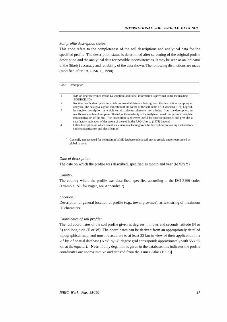
Soil profile description status:
This code refers to the completeness of the soil descriptions and analytical data for the
specified profile. The description status is determined after screening of the original profile
description and the analytical data for possible inconsistencies. It may be seen as an indicator
of the (likely) accuracy and reliability of the data shown. The following distinctions are made
(modified after FAO-ISRIC, 1990).
Code Description
1 ISIS or other Reference Pedon Description (additional information is provided under the heading SOURCE_ID).
2 Routine profile description in which no essential data are lacking from the description, sampling oranalysis. The data give a good indication of the nature of the soil in the FAO-Unesco (1974) Legend.
3 Incomplete description in which certain relevant elements are missing from the description, aninsufficient number of samples collected, or the reliability of the analytical data do not permit a completecharacterization of the soil. The description is however useful for specific purposes and provides asatisfactory indication of the nature of the soil in the FAO-Unesco (1974) Legend.
4 Other descriptions in which essential elements are lacking from the description, preventing a satisfactorysoil characterization and classification*.
* Generally not accepted for inclusion in WISE database unless soil unit is grossly under represented inglobal data set.
Date of description:
The date on which the profile was described, specified as month and year (MM/YY).
Country:
The country where the profile was described, specified according to the ISO-3166 codes
(Example: NE for Niger, see Appendix 7).
Location:
Description of general location of profile (e.g., town, province), as text string of maximum
50 characters.
Coordinates of soil profile:
The full coordinates of the soil profile given as degrees, minutes and seconds latitude (N or
S) and longitude (E or W). The coordinates can be derived from an appropriately detailed
topographical map, and must be accurate to at least 25 km in view of their application in a
½E by ½E spatial database (A ½E by ½E degree grid corresponds approximately with 55 x 55
km at the equator). [Note: if only deg. min. is given in the database, this indicates the profile
coordinates are approximative and derived from the Times Atlas (1993)].
INTERNATIONAL SOIL PROFILE DATA SET
28 ISRIC Work. Pap. 95/10b
Altitude:
The altitude of the soil profile relative to mean sea level, specified in meters. This information
can be derived from a suitably detailed topographical map. (Note: 1 foot = 0.3048 m).
Landform:
This refers to the major landforms, which are described principally by their morphology and
not by their genetic origin, or processes responsible for their shape. The first differentiating
criterion is the dominant slope, followed by relief intensity as used in the SOTER manual
(Van Engelen and Wen, 1993 p. 24-25):
Code Landform Description
L Level land Land with characteristic slopes of 0-8 %, and a relief intensity of less than 100 mper km.
S Sloping land Land with characteristic slopes of 8-30 % and a relief intensity of more than 50 m per slope unit. Areas with a limited relief intensity (< 50 m per slope unit) but slopes in excess of 8% are included, as are isolated mountains (relief intensity > 600 m) with slopes of 8-30 %.
T Steep land Land with characteristic slopes of over 30 % and a relief intensity of mostly more than600 m per 2 km.
C Land with com- Land made up of steep elements together with sloping or level land, or sloping landposite landforms with level land, in which at least 20 % of the area consists of land with the lesser slope.
Codes for second level major landforms are used in the WISE database. The initial breakdown
of major landforms is made according to the procedures of the SOTER Manual:
First level Second level Gradient Relief intensity
L Level land LP plainLL plateauLD depressionLF low-gradient footslopeLV valley floor
T Steep land TM high-gradient mountainTH high-gradient hillTE high-grad. escarpment zoneTV high gradient valleys
> 30% > 30%> 30% > 30%
> 600 m/2km < 600 m/2km > 600 m/2km variable
C Land with composite CV valleyCL narrow plateauCD major depression
> 8%> 8%> 8%
variable variable variable
Note: s.u. stands for slope unit. Where this is not clear from the gradient or relief intensity, the distinction betweenthe various second level major landforms follows from the description.
INTERNATIONAL SOIL PROFILE DATA SET
ISRIC Work. Pap. 95/10b 29
Landscape position:
The physiographic position of the site where the profile is located, specified according to the
following system (FAO-ISRIC, 1990 p. 7).
Code Description
Position in undulating to mountainous terrainCR Crest/top UP Upper slope MS Middle slope LS Lower slope BO Bottom (flat)
Position in flat or almost flat terrainHI Higher partIN Intermediate partLO Lower partBO Bottom (drainage line)
Aspect:
The aspect of the site coded using the following format: N, NNE, NE, ENE, E, ..., NNW. In
case of flat or almost level land, the aspect is indicated as O (letter) .
N NNW NNE NW NE WNW ENE W O E WSW ESE SW SE SSW SSE S
Slope gradient:
The slope refers to the inclination of the land immediately surrounding the site. The measured
or estimated slope angle is specified to the nearest per cent.
Drainage class:
The internal drainage class is coded according to the conventions of FAO-ISRIC (1990 p. 20).
In WISE, intergrades of two neighbouring drainage classes may be indicated by a combination
of two codes. For instance "VP", represents a soil with very poor to poor internal drainage.
Code Description
V very poorly drainedP poorly drainedI somewhat poorly (imperfectly) drainedM moderately well drainedW well drainedS somewhat excessively drainedE excessively drained
INTERNATIONAL SOIL PROFILE DATA SET
30 ISRIC Work. Pap. 95/10b
Depth of groundwater table:
The measured or estimated depth to the groundwater table, if present/known, indicating both
the mean highest and mean lowest values during the year. Depths are specified in centimetres
from the surface. If the water-table always occurs at a great depth, this can by entering similar
values for the both the mean high and low values (e.g., 200 cm).
Soil depth to rock:
The average measured or estimated depth, in cm, from the surface to a layer that physically
precludes the development of most roots. Limitations of a chemical nature, such as high levels
of salt/alkali, are not considered under this heading as they are often of a transient nature,
being prone to change with agricultural practices.
Parent material/lithology:
The main parent rock/material over which the soil has been formed is coded using the
categories considered in the SOTER manual and FAO-ISRIC (1990, p. 14). Additional codes,
introduced in the context of the WISE project, and are indicated by an asterisk:
Major class Group Type
I Igneous rocks IA acid igneous IA1 graniteIA2 grano-dioriteIA3 quartz-dioriteIA4 rhyolite
II intermediate igneous II1 andesite, trachyte,phonolite
II2 diorite-syenite
IB basic igneous IB1 gabbroIB2 basaltIB3 dolerite
IU ultrabasic igneous IU1 peridotiteIU2 pyroxeniteIU3 ilmenite, magnetite,
ironstone, serpentine
M Metamorphic rocks MA acid metamorphic MA1 quartziteMA2 gneiss, migmatiteMA3* slate, phylliteMA4* schists
SO organic SO1 limestone, other carb. rocksSO2 marl and other mixturesSO3 coals, bitumen and rel.
rocksSE evaporites SE1 anhydrite, gypsum
SE2 halite
INTERNATIONAL SOIL PROFILE DATA SET
ISRIC Work. Pap. 95/10b 31
(Parent material/lithology cont.)
Major class Group Type
U Unconsolidated UF fluvialUL lacustrineUM marineUC colluvialUE eolianUG glacialUP pyroclasticUO organicUX* soft laterite and
ferruginous materialsUY* hardened laterite and
ferruginous materials
* Additional, tentative codes
Remarks on parent material/lithology:
When necessary, additional remarks about the parent material can be specified as text on the
proforma, with a maximum length of 50 characters.
Köppen climate classification:
The climate at the site is classified according to the Köppen system which considers
precipitation effectiveness for plant growth as the major classification factor, and uses the
appropriate seasonal values of temperature and precipitation to determine the limits of
climatic groupings. The Köppen system figures a shorthand code of letters designating major
climate groups, subgroups within these major groups, with further subdivisions to distinguish
particular seasonal characteristics of temperature and precipitation (adapted from Strahler,
1969 p. 224; Times Atlas, 1993).
a) Major climate groups
The following major climate groups are considered:
Code Classification and description
A Tropical (rainy) climates: Average temperature of every month is above 18 oC. These climates haveno winter season. Annual rainfall is large and exceeds annual evaporation.
B Dry: Potential evaporation exceeds precipitation on the average throughout the year. No water surplus;hence no permanent streams originate in B climate zones.
C Warm temperate (mesothermal) climates: Coldest month has an average temperature under 18 oC, butabove -3 oC. The C climates thus have both a summer and a winter season.
D Snow (microthermal) climates: Coldest month average temperature under -3 oC. Average temperatureof the warmest month above 10 oC, that isotherm corresponding approximately with pole-ward limitof forest growth.
E Ice climates: A polar climate type with average temperature in no month averaging over 10 oC. Theseclimates have no true summer
H Mountain/Highland climates
INTERNATIONAL SOIL PROFILE DATA SET
32 ISRIC Work. Pap. 95/10b
b) Subgroups
Subgroups within the major climate groups are designated by a second letter according to the
following code:
Code Description
S* Steppe climate, a semiarid climate with about 380 to 760 mm of rainfall annually at low latitudes.
W Desert climate. Arid climate. Most regions included have less than 250 mm of rainfall annually.
f Moist. Adequate precipitation in all months. No dry season. This modifier is applied to major climate types A, C and D.
w Dry season in winter of the respective hemisphere (low-sun season) s Dry season in summer of the respective hemisphere (high-sun season) m Rainforest climate despite a short dry season in monsoon type of precipitation
cycle. Applies only to A climates.
* The letters S and W are applied only to the dry climates (i.e., BS and BW).
From combinations of the two letter groups, 12 distinct climates emerge as follows:
Code Description
Af Tropical rainforest (also Am a variant of Af) Aw Tropical savanna BS Steppe climate BW Desert climate Cw Temperate rainy (humid mesothermal) climate with dry winter Cf Temperate rainy (humid mesothermal) climate moist all seasons Cs Temperate rainy (humid mesothermal) climate with dry summer Df Cold snowy forests (humid microthermal) climate moist in all seasons Dw Cold snowy forest (humid microthermal) climate with dry winter ET Tundra climate EF Climates of perpetual frost (ice-caps) H Mountain/Highland climates (undifferentiated)
c) A third letter may be added to differentiate still more variations. Meanings are as follows:
Code Description
a With hot summer; warmest month over 22 oC (C and D climates) b With warm summer; warmest month below 22 oC (C and D climates) c With cool, short summer; fewer than four months over 10 oC (C and D climates) d With very cold winter; coldest months below - 38 oC (D climates only) h Dry-hot; mean annual temperature over 18 oC (B climates only) k Dry-cold; climates annual temperature under 18 oC (B climates only).
The unique, Köppen codes allowed in WISE are listed in file KEYKOPPE.DBF. For example
BWk, which refers to a dry-cold, desert climate.
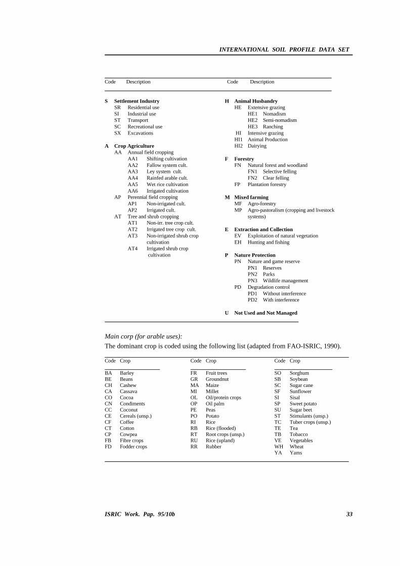
Current land use:
The current land use at the site is coded using the classes given by FAO-ISRIC (1990 p. 13),
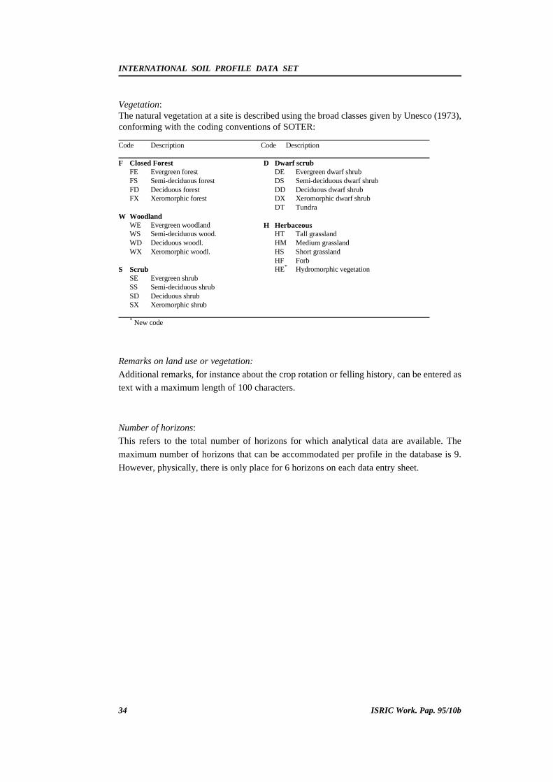
Vegetation:The natural vegetation at a site is described using the broad classes given by Unesco (1973),conforming with the coding conventions of SOTER:
H HerbaceousHT Tall grasslandHM Medium grasslandHS Short grasslandHF ForbHE* Hydromorphic vegetation
* New code
Remarks on land use or vegetation:
Additional remarks, for instance about the crop rotation or felling history, can be entered as
text with a maximum length of 100 characters.
Number of horizons:
This refers to the total number of horizons for which analytical data are available. The
maximum number of horizons that can be accommodated per profile in the database is 9.
However, physically, there is only place for 6 horizons on each data entry sheet.
INTERNATIONAL SOIL PROFILE DATA SET
ISRIC Work. Pap. 95/10b 35
B - HORIZON ATTRIBUTES
Horizon number:
This number is automatically created by the WISE input module. Data for the main horizons
must be entered from the surface downwards. If more than 9 soil horizons are described in
the original source, it may be necessary to ‘regroup’ this information to a smaller number.
This should only be done for the subsoil, for example, by averaging numeric data for similar
horizons such as a Btg1 and Btg2.
Horizon designation:
Whenever possible, the horizon designation should be given according to the terminology of
FAO-ISRIC (1990).
Top (upper) depth:
Upper depth of horizon (cm). In case of a litter layer, use negative numbers (e.g., top depth
of -20 cm to bottom depth of 0 cm). If the original depth of a horizon is given as e.g. 30/40
cm, the horizon depth is entered as (30+40)/2= 35 cm.
Bottom (lower) depth:
Lower depth of horizon (cm). If the lower depth of a profile is not indicated and analytical
data are available for the last horizon, the assumption is that this horizon is 15 cm thick. For
example, 75+ cm would imply a lower depth of 90 cm.
Organic carbon:
Organic carbon (% by weight) is specified with 2 decimal places. The code for the
measurement method is to be specified separately on Form C. [Note: The codes for the
analytical methods are held in KEYMETHO.DBF. The list of codes will grow as new
analytical procedures are encountered during data collection. The most recent list can be
printed with option <6> of the selection menu of WISE (see Section 4.5)].
Total Nitrogen:
Total nitrogen (% by weight) is rounded to 2 decimal places. The code for the measurement
method is to be specified separately on Form C (see KEYMETHO.DBF).
Available P:
Available (extractable) P content, by weight, in mg P2O5 kg-1 soil. The code for the
measurement method is to be specified separately on Form C (see KEYMETHO.DBF).
pH-H2O:
Measured in water at a soil:water ratio which is to be specified in the ‘analytical methods’
key-file. One decimal is adequate.
INTERNATIONAL SOIL PROFILE DATA SET
36 ISRIC Work. Pap. 95/10b
pH-KCL:
Measured in 1 M KCl solution at the soil:solution ratio specified with the data. The code for
the measurement method is to be specified separately on Form C (see KEYMETHO.DBF).
pH-CaCl2:
Measured in 1 M CaCl2 solution at the soil:solution ratio specified with the data. The code for
the measurement method is to be specified separately on Form C (see KEYMETHO.DBF).
Electrical conductivity (EC):
Specify the EC for the horizon, indicating the soil:water ratio. The unit used is mS cm-1 or dS
m-1, originally mmho cm-1, at 25 oC. The code for the measurement method is to be specified
separately on Form C (see KEYMETHO.DBF).
CaCO3:
Total CaCO3 content (% by weight) is rounded off to the nearest integer. The code for the
measurement method is to be specified separately on Form C (see KEYMETHO.DBF).
CaSO4:
Total gypsum (CaSO4.2H2O) content, by weight %, is rounded off to the nearest integer. The
code for the measurement method is to be specified separately on Form C (see
KEYMETHO.DBF).
Exchangeable bases (Ca2+, Mg2+, K+ and Na+):
To be specified in cmol(+) kg-1, using 1 decimal. The code for the measurement method is to
be specified separately on Form C (see KEYMETHO.DBF).
Exchangeable acidity (Al3+ and H+):
Obtained with a percolation of a soil sample with a 1 M KCl solution. Exchangeable acidity
is measured by titration of the percolate, and exchangeable aluminum is determined separately
in the percolate. Exchangeable acidity is specified in cmol(+) kg-1, using 1 decimal. [Note:
Values for exchangeable acidity, determined in 1 M KCl percolate, and extractable acidity,
equilibrated with a BaCl2-TEA buffer at pH 8.2, refer to different measurement methods!]
Exchangeable aluminum (Al3+):
Exchangeable aluminum, in cmol(+) kg-1, as determined separately in the percolate described
above.
Cation exchange capacity (CEC):
CEC is given in cmol(+) kg-1, using 1 decimal, according to the method specified on Form
C.
Effective cation exchange capacity (ECEC):
ECEC is determined by summation of exchangeable bases and exchangeable acidity, and
expressed in cmol(+) kg-1 using 1 decimal (i.e., ECEC= Exch[Ca2+ + Mg2+ + K+ + Na+] +
INTERNATIONAL SOIL PROFILE DATA SET
ISRIC Work. Pap. 95/10b 37
Exch[H+ + Al3+]). [Note: The above definition is used in the WISE database to conform with
the definition of the ISRIC laboratory (Van Reeuwijk, 1990, p. 11.1)].
Base saturation (BS):
Specified as nearest integer, and calculated as sum of exchangeable cation bases (Ca2+, Mg2+,
K+ and Na+) divided by the CEC, measured with the specified CEC method, times 100%.
Matrix colour, dry:
The dry colour is specified using the Munsell Colour Charts. Colour codes have the general
form: hue, value, chroma (e.g., 5YR5/3). All "complex" Munsell codes must be rounded off.
For example, 10YR3.5/1 would become 10YR4/1.
Matrix colour, moist:
The moist colour is specified using the Munsell Colour Charts (e.g., 5YR3/2).
Mottling:
Mottling in a horizon is characterized by its abundance (after FAO-ISRIC, 1990 p. 42).
Code Description % of occurrence
N none positive statement V very few 0-2 % F few 2-5 % C common 5-15 % M many 15-40 % A abundant > 40 %
Roots:
The presence of roots is described using a two character code (FAO-ISRIC, 1990 p. 63). The
first letter of this code refers to the overall size of the roots, and the second letter to their
abundance (e.g., MC stands for many coarse roots).
- Abundance of roots (expressed as number of roots per square decimeter):
Code Quantity Description
O no roots 0 V very few 1-20F few 20-50 C common 50-200M Many > 200
INTERNATIONAL SOIL PROFILE DATA SET
38 ISRIC Work. Pap. 95/10b
- Description of root sizes:
Code Description Diameter (mm)
V very fine < 0.5 mmF fine 0.5-2 mmM medium 2-5 mmC coarse > 5 mmX all very fine roots to coarse
Soil structure:
The type of soil structure is described according to the classes of FAO-ISRIC (1990 p. 51):
Code Description of class
SG single grain MA massive CR crumb GR granular PR prismatic PS subangular prismatic CO columnar AB angular blocky SB subangular blocky
Code Description
AS angular and subangular blocky SA subangular and angular blocky SN nutty subangular blocky AW angular blocky wedge-shaped AP angular blocky parallelepiped PL platy RS rock structure SS stratified structure
Particle size distribution:The particle size distribution refers to the fine earth fraction only (< 2 mm). The weightpercentages of sand-, silt- and clay-size materials are given as integers. The analyticalprocedure and ‘esd’ or equivalent spherical diameter for the clay-, silt-, and sand-sizefractions must be documented on Form C. For example: pipette method, full dispersion; esd:<2 µm, < 50 µm and < 2 mm.
Stone and gravel content: Give a visual estimate of the percentage of large rock and mineral fragments with a diameterlarger than 2 mm, rounded off to the nearest 5 per cent.
Bulk density: Bulk density (oven dry sample) is given as g cm-3, using two decimals.
Soil water retention:The volume percentage of water (MC) in the soil horizon, at the considered pF-values (i.e.,0.0, 1.0, 1.5, 1.7, 2.0, 2.3, 2.5, 2.7, 4.3, 3.7 and 4.2; see WISEHOR.DBF p. 27), is to bespecified as an integer. The moisture content is expressed on a percent by volume basis:
MC (% by volume v/v) = MC (% by weight w/w) x bulk density (kg m-3)
Selected pF-values or suctions, at which the soil water retention measurements were made,can be entered on the data entry sheet. (Indicate which pF values are considered to correspondwith the Field Capacity and the Permanent Wilting Point so that the Available WaterCapacity (AWC) can be calculated). [Note: pF is the log10 [head(cm of water)], i.e. a head of100 cm of water corresponds with a pF of 2.0. (1 bar = 1017 cm of water = 100 kPa = 0.987atmosphere)]
INTERNATIONAL SOIL PROFILE DATA SET
ISRIC Work. Pap. 95/10b 39
Hydraulic conductivity:Hydraulic conductivity or permeability (cm hr-1) varies with soil moisture conditions (pFvalues). Two values can be entered: (a) saturated hydraulic conductivity, and (b) non-saturatedhydraulic conductivity.
INTERNATIONAL SOIL PROFILE DATA SET
40 ISRIC Work. Pap. 95/10b
C ——- SOURCE OF DATA
SOURCE_ID:Unique code for source (e.g., soil monograph or digital database).
Source:Authors and initials, as text string (For example: Van Waveren, E.J. and Bos, A.B.).
Year:Year data during which the profile data were collected/described (For example: 1988).
Title:Title of source in which data are published, as text string (For example: ISRIC SoilInformation System).
Series/publisher/year:Self-explanatory, as text string (For example: Technical Paper 15, International SoilReference and Information Centre, Wageningen).
LAB_ID:Unique reference code for laboratory where analyses for relevant profile(s) were made (e.g.,FR01).
Laboratory name:Name of laboratory where analyses were made, as text string.
Coding system for analytical methods:- Organic Carbon (OC__)- Total Nitrogen (TN__)- Available Phosphorus (TP__)- pH-water (PH__)- pH-KCl (PK__)- pH-CaCl2 (PC__)- Electrical conductivity (EL__)- Free CaCO3 (CA__)- Gypsum (GY__)- Exch. Ca, Mg, K, and Na (EX__)- Exch. acidity and Aluminum (EA__)- CEC soil (CS__)- ECEC soil (CE__)- Base saturation (BS__)- Particle size distribution (TE__)- Bulk density (BD__)- Moisture content (MC__)- Hydraulic conductivity (HC__)
Note: All codes, plus a brief description of the corresponding analytical procedures, aredocumented in KEYMETHO.DBF, for example "OC01" stands for "Method of Walkley-Black". This information can be printed with option <6> of the TOOLS menu.
INTERNATIONAL SOIL PROFILE DATA SET
ISRIC Work. Pap. 95/10b 41
Appendix 7. List of country ISO codes
AF AfghanistanAL AlbaniaDZ AlgeriaAS American Samoa AD AndorraAO Angola AI AnguillaAQ AntarcticaAG Antigua and BarbudaAR ArgentinaAM ArmeniaAW ArubaAU AustraliaAT Austria AZ Azerbaijan BS Bahamas BH Bahrain BD Bangladesh BB Barbados BE Belgium BZ Belize BJ Benin BT Bhutan BO Bolivia BW Botswana BV Bouvet Island BR Brazil IO Brit. Ind. Ocean TerritoryBN Brunei DarussalamBG Bulgaria BF Burkina Faso BU Burma BI Burundi BY Belarus CM Cameroon CA Canada CV Cape Verde KY Cayman Islands CF Central African RepublicTD Chad CL Chile CN China CX Christmas Island CC Cocos Islands CO Colombia CG Congo CK Cook Islands CR Costa Rica HR Croatia CU Cuba CY Cyprus CS Czechoslovakia CI Côte d'Ivoire DK DenmarkDJ Djibouti DM DominicaDO Dominican RepublicTP East TimorEC EcuadorEG EgyptSV El SalvadorGQ Equatorial GuineaEE EstoniaET EthiopiaFK Falkland IslandsFO Faroe (Islands)
MD Moldova, Republic ofMC MonacoMN MongoliaMS MontserratMA MoroccoMZ MozambiqueNA NamibiaNR NauruNP NepalNL NetherlandsAN Netherlands AntillesNT Neutral ZoneNC New CaledoniaNZ New ZealandNI NicaraguaNE NigerNG NigeriaNU NiueNF Norfolk IslandMP Northern Mariana IslandsNO NorwayOM OmanPK PakistanPW PalauPA PanamaPG Papua New GuineaPY ParaguayPE PeruPH PhilippinesPN PitcairnPL PolandPT PortugalPR Puerto RicoQA QatarRE ReunionRO RomaniaRU Russian FederationRW RwandaLC Saint LuciaWS SamoaSM San MarinoST Sao Tome and PrincipeSA Saudi ArabiaSN SenegalSC SeychellesSL Sierra LeoneSG Singapore
SB Solomon IslandsSO SomaliaZA South AfricaES SpainLK Sri LankaSH St. HelenaKN St. Kitts and NevisPM St. Pierre and MiquelonVC St. Vincent and the GrenadinesSD SudanSR SurinameSJ Svalbard and Jan Mayen SZ SwazilandSE SwedenCH SwitzerlandSY Syrian Arab RepublicTW Taiwan, Province ChinaTJ TajikistanTZ Tanzania, United Rep. ofTH Thailand TG TogoTK TokelauTO TongaTT Trinidad and TobagoTN TunisiaTR TurkeyTM TurkmenistanTC Turks and Caicos IslandsTV TuvaluSU USSRUG UgandaUA UkraineAE United Arab EmiratesGB United KingdomUS United StatesUY UruguayUM US. Minor Outlying IslandsUZ UzbekistanVU VanuatuVA Vatican City StateVE VenezuelaVN Viet NamVG Virgin Islands (U.K.)VI Virgin Islands (U.S.)WF Wallis and Futuna IslandsEH Western SaharaYE YemenYD Yemen, DemocraticYU YugoslaviaZR ZaireZM ZambiaZW Zimbabwe


![wrap.warwick.ac.ukwrap.warwick.ac.uk/58289/1/WRAP_Koskela_KJS13_Arxiv.pdfDe Iorio and Gri ths derived an approximation to nite alleles CSDs based on the Fleming{Viot generator ([7],](https://static.documents.pub/doc/80x56/5e93961ad4e48f6740561f3a/wrap-de-iorio-and-gri-ths-derived-an-approximation-to-nite-alleles-csds-based-on.jpg)


