cm a STATE OF UTAH DIVISION C >lL,GAS AND MfNING 5. Laase Designation and Serial Number: ML-46342 APPLICATION FOR PERMIT TO DRILL OR DEEPEN B.Nindu,NbueemTdbeName: N/A 1A Typ••«work: DRILL DEEPEN O N/A e.Typeerwen: OfL GAS OTHER: SINGLEZONEg MULTIPLEZONED e.Fannorwm TEASDALE 2. Name of Operalor: 9. Wel Number: RANGELAND PETROLEUM CORPORATION #1 3. Address and Telephone Number: 10. Field and Pool, m WUdcat 210 NORTH MAIN ST., MIDLAND, TX. 79701 (915) 686-8983 WILDCAT 4. Locatkmof Wen (Fontages) 11. Otr/Ott, Secdon, Township, Range, Meria:sc.: neu,,.o.: 540' FNL & 660' FWL NWNW 16-30S-6E n P..po..a eroa.eing zon.: S AME 14. Distance in miles and dhecdon from nearest town a post oNice: 12. County: 13. State: 9 MILES SE OF TORREY WAYNE UNH 15. Distance to nearest 16. Number af acres In tease: 17. Number of acres assigned to this wei: property a taase Sne geog: 5 6 O ' 6 4 0 40 10. Dietance to nearest well, dtWIIng, 19. Proposed Depth: 20. Antary a cable tools: completed, m appned for, on this lease geog: N/ A 6 , OOO · ROTARY 21. Bevadons (show wheUser DF, NT,GR, etc.): 7, 8 8 2 ' UNGRADED Opprould d win f 1996 23 PROPOSED CASING ANE CEMENTING PROGRAM 812EOF HOLE GRADE,812EOF CASING WEIGHTPER FOOT SEnlNG DEPM OUANNY OF CEMENT 70" 16" CONDUCTOR 50' bU CU. EI. öt IU SUKVAtt 17-1(4" 9-5/0" K-55 36# 2,150' 1350 LU. E I. at tu muutAtt 7-7/8" 5-1/2" J-55 17# 6,000' Isub Lu. E I. 6e iù ¿,ùùù' DESCAIBE PROPOSED PROGRAM: Wproposal is to deepen, give data on present productive zone and proposed new producdve anne. E proposal is to drgi m deepen direedonally, give pertinent subsurface locadone and fneasured and true verdcel depths. Give blowout preventer program, Wany. SEPL51996 am.asion.tur.: (505) 466-8120 CONSULTDIVOF OIL GAS & N G20-96 (Thie space for State use enig) API Number Ass o (1\934 (See instructions on Reverse
Transcript
cm a STATE OF UTAH
DIVISION C >lL,GAS AND MfNING5. Laase Designation and Serial Number:
ML-46342
APPLICATION FOR PERMIT TO DRILL OR DEEPEN B.Nindu,NbueemTdbeName:
N/A1A Typ••«work: DRILL DEEPEN O N/Ae.Typeerwen: OfL GAS OTHER: SINGLEZONEg MULTIPLEZONEDe.Fannorwm
TEASDALE2. Name of Operalor: 9. Wel Number:
RANGELAND PETROLEUM CORPORATION # 13. Address and Telephone Number: 10. Field and Pool, m WUdcat
210 NORTH MAIN ST., MIDLAND, TX. 79701 (915) 686-8983 WILDCAT4. Locatkmof Wen (Fontages) 11. Otr/Ott, Secdon, Township, Range, Meria:sc.:
neu,,.o.: 540' FNL & 660' FWL NWNW 16-30S-6E
n P..po..a eroa.eingzon.:SAME
14. Distance in miles and dhecdon from nearest town a post oNice: 12. County: 13. State:
9 MILES SE OF TORREY WAYNE UNH
15. Distance to nearest 16. Number af acres In tease: 17. Number of acres assigned to thiswei:property a taase Sne geog: 5 6 O ' 6 4 0 4 0
10. Dietance to nearest well, dtWIIng, 19. Proposed Depth: 20. Antary a cable tools:completed, m appned for, on this lease geog: N/ A 6 , OOO · ROTARY
70" 16" CONDUCTOR 50' bU CU. EI. öt IU SUKVAtt17-1(4" 9-5/0" K-55 36# 2,150' 1350 LU. E I. at tu muutAtt7-7/8" 5-1/2" J-55 17# 6,000' Isub Lu. E I. 6e iù ¿,ùùù'
DESCAIBEPROPOSEDPROGRAM:Wproposal is to deepen, give data on present productive zone and proposed new producdve anne. E proposal is to drgi m deepen direedonally, give pertinentsubsurface locadone and fneasured and trueverdcel depths. Give blowout preventer program, Wany.
Rangeland Petroleum Corporation PAGE 1Teasdale #1540' FNL & 660' FWLSec. 16, T. 30 S., R. 6 E.Wayne County, Utah
Drillinq Program
1. Formation Name Depth from GL Depth from KB Subsea DepthSinbad Ls O' 12' +7,882'
Kaibab Ls 150' 162' +7,732'
Coconino Ss 290' 302' +7,592'
Cedar Mesa Ss 550' 562' +7,332'
Upper Hermosa 1,540' 1,552' +6,342'
Redwall Ls 2,650' 2,662' +5,232'
Devo nian 3,1 60' 3, 172' +4,722
Lynch (Muav) Ls 3,710' 3,722' +4,172'
Bright Angel 4,930' 4,942' +2,592'
Tapeats Ss 5,600' 5,612' +2,282'
Precambrian Shale 5,800' 5,812' +2,082'
Total Depth (TD) 6,000' 6,012' +1,882'* All depths are based on an ungraded ground level of 7,882'.
2. NOTABLEZONES
Tapeats sandstone is the target zone. No other mineral zones are expected.Redwall is the only expected water zone.
3. PRESSURECONTROL(Also see "5." on PAGE 2)
An 11" x 3,000 psi double ram BOP with 3,000 psi choke manifold will beused from bottom of surface casing to TD. (A typical 3,000 psi BOP is onPage 4. The actual model will not be known until the bid is let.) Pressuretest casing to 1,000 psi and annular preventer to 1,500 psi before drillingout. Test valves, manifold, lines, pipe, and blank to 3,000 psi. Place testplug in bottom of wellhead and retest surface equipment every 30 days.
PER S WEST.lNC
PROVIDING PERMlls im I ANI) lisl
Rangeland Petroleum Corporation PAGE 2Teasdale #1540' FNL & 660' FWLSec. 1 6, T. 30 S., R. 6 E.Wayne County, Utah
BOP system will be consistent with API RP53. Pressure tests will beconducted before drilling out from under all casing strings which are setand cemented in place. BOP controls will be installed before drilling thesurface casing plug, and will stay in use until the well is completed orabandoned. BOPs will be inspected and operated daily to assure goodmechanical working order. All BOP mechanical tests, pressure tests, andinspections will be recorded on the drillers tog or daily drilling report.
4. CASING& CEMENTING
Hole Size O.D. Weight Grade Tvoe =Settinq Depth20" 16" Conductor Pipe New 50'12-1/4" 9-5/8" 36 K-55 ST&C New 2,150'
7-7/8" 5-1/2" 17 J-55 LT&C New 6,000'
Surface casing cement will be circulated to surface. Premium cement(~190 cu. ft.) will be run from ~2,150' to ~1,850'. Lite cement (~~1,160cu.ft.) will be run from ~1,850' to surface. An additional ~300 sx will beused to top out cement if there are no returns. Volumes are calculated at100% excess.
Long string will be cemented from TD to 2,000'. Premium cement (260 cu.ft.) will be run from TD to ~5,000'. Light cement (~600 cu. ft.) will be runfrom ~5,000' to ~3,700'. Stage tool will be set at ~3,700'. Premiumcement (~130 cu. ft.) will be run from ~3,700' to ~3,200'. Light cement(~315 cu. ft.) will be run from ~3,200' to ~2,000'. Vol.umes are calculatedat 50% excess. Actual volumes will be determined by caliper log.
5. MUDPROGRAM
Aerated LSND will be used from surface to ~2,150'. Mud or aerated LSNDwill be used from ~~2,150' to TD depending upon hole conditions. Weighted
PER TS WEST,INC
PROVIDING PERMI I S tot I \N1)
Rangeland Petroleum Corporation PAGE 3Teasdale #1540' FNL & 660' FWLSec. 16, T. 30 S., R. 6 E.Wayne County, Utah
mud and lost circulation material will be on site. A mud logger will be onsite once the well is below 5,000' to collect samples at 10' intervals.
6. CORING,TESTING,& LOGGING
No cores are planned. A DST may be run in the Tapeats. Mud, compensatedneutron, formation density, dual induction/SP, microlog, sonic, anddipmeter logs may be run from ~2,150' to TD.
7. DOWNHOLECONDITIONS
The maximum anticipated bottom hole pressure is ~2,300 psi. No abnormalpressures, temperatures, or hydrogen sulfide are expected. Water flowsand lost circulation are expected.
8. MISCELLANEOUS
The anticipated spud date is November 1, 1996. It is expected it will take~30 days to drill the well and ~1 5 days to complete the well.
PERMITS WEST, NC
PROVIDING PERMllS lor i AND
Rangeland Petroleum Corporation PAGE 4Teasdale #1540' FNL & 660' FWLSec. 16, T. 30 S., R. 6 E.Wayne County, Utah
FLOWLINEFILL
TYPICALBOPSTACKANNULAR &CHOKEMANIFOLD
RAM There will be et least 2 chokesand2 chokeline valves (3" minimum).The choke linewill be 3" in diameter. There will be apressure gaugeon thechokemanifold.
TO ÞlT 4Ki!Iline will beminimum2" diameterandhave 2 valves, oneof which shall .
be a minimum 2" check valve.Upperkelly cockwill havehandle available.
Safety valve andsubswill fit all drill string connectionsin use.All BOPEconnectionssubjectedtowellpressure will be flanged, welded,or clamped.
PER S WEST.mo.PROVIDING PERMITS for the ENEROY
Rangeland Petroleum Corporation PAGE 5Teasdale #1540' FNL & 660' FWLSec. 16, T. 30 S., R. 6 E.Wayne County, Utah
Surface Use Plan
1. EXISTINGROADS& DIRECTIONS(See PAGES 10 & 11)
From the junction of U-12 and U-24 on the east side of Torrey, Utah ...
Go S ~7 miles on Utah 12Then turn left and go SE and then NE 3.9 mi. on the Miners Mountain RoadThen turn right and go SE 0.25 mi. on a good dirt road to an old cabinThen turn left and go NE 0.45 mi. on a dirt roadThen turn left and go N 175' on a dirt roadThen turn right and E 400' on a dirt roadThen turn right and go SE 20' to the NW corner of the pad
2. ROADTO BE BUILTOR UPGRADED
Twenty feet of new road will be built and 0.55 mi. of existing road willbe upgraded. Improvements will initially be limited to flat blading a 16'wide travel surface and limbing and felling trees where needed. Limbing(cut at trunk so as not to leave stubs) will be used instead of felling ifit will provide adequate safe passage. The south road of the two roadswhich bracket the wellsite will be blocked.
If production results, then all of the road from the well to the countyroad (Miners Mountain Road) will be crowned, ditched, and culverted.Travel surface will remain 16' and maximum disturbed width will notexceed 50'. Fifty feet will only be necessary on turns.
3. EXISTINGWELLS
There are no existing oil, gas, water, injection, or disposal wells withina 1 mile radius.
PER S WEST.INC
PROVIDING PERMITS tar IAND
Rangeland Petroleum Corporation PAGE 6Teasdale #1540' FNL & 660' FWLSec. 1 6, T. 30 S., R. 6 E.Wayne County, Utah
4. PROPOSED PRODUCTIONFACILITIES
Production facilities may include four 16' to 20' high 500 bbl tanks.Three steel tanks will for oil. One fiberglass tank will be for water.Vertical 4 x 20 heater-treater and 2 x 10 two stage separators may alsobe on site. The pumpjack and these facilities will be painted a flatjuniper green color. Painting will be completed within 6 months ofinstallation. Parts required to comply with OSHA colors will beexcluded.
The tank battery will be surrounded by a dike of sufficient capacity tocontain 150% of the storage capacity of the battery. All loading lineswill be placed inside the dike.
5. WATER SUPPLY
Water will be piped from Carcass Creek in 11-30s-5e. Pace Ranch willprovide the water right. A surface pipeline (<_6"diameter) will be laidalong the access road. If water in the pipe freezes, then water will betrucked to the wellsite. An Application to Appropriate Water will befiled with the Utah Div. of Water Rights.
6. CONSTRUCTIONMATERIALS& METHODS
Topsoil, brush, and trees will be stripped and stockpiled north and southof the pad. The reserve pit will be lined with minifnum 12 mil plastic.The south road which crosses the pad will be blocked.
7. WASTE DISPOSAL
At least 80% of the reserve pit capacity will be in cut. The pit will be
PER I S WEST.INC.
PROVIDING PERMI(S lor i AND
Rangeland Petroleum Corporation PAGE 7Teasdale #1540' FNL & 660' FWLSec. 1 6, T. 30 S., R. 6 E.Wayne County, Utah
fenced 4' high on 3 sides with 4 strands of barbed wire or woven wiretopped with barbed wire. The 4th side will be fenced once the rig movesoff hole. The fence will be kept in good repair while the pit dries.
All trash will be placed in a trash cage. When full, it will be hauled to astate approved landfill. There will be no trash burning or disposal oftrash in the reserve pit. Chemical toilets will be used for human waste.
8. ANCILLARY FACILITIES
There will be no airstrip or formal camp. Camper trailers will be on sitefor the company man, roughnecks, mud logger, tool pusher, etc.
9. WELL SITE LAYOUT
See PAGES 12 & 13 for depictions of the well pad, cross sections, cutand fill diagrams, reserve pit, burn pit, access road onto the pad,parking, living facilities, and rig orientation.
10. RECLAMATION
After completing drilling, the wellsite and immediate area will becleared of all debris and material not needed for production.
Reclamation will start when the reserve pit is dry. A'll areas not neededfor production will be backfilled, recontoured to match natural contours,and reserved topsoil, trees, and brush evenly spread. If the well is aproducer, then enough topsoil will be kept aside to reclaim the rest ofthe pad. Disturbed areas will be ripped, harrowed, or scarified beforeseeding. The south road which crosses the pad will be left closed andreclaimed. Areas widened by road upgrading will be similarly reclaimed.
PER S WEST-PROVIDING PERMITS for ! \ND
Rangeland Petroleum Corporation PAGE 8Teasdale #1540' FNL & 660' FWLSec. 16, T. 30 S., R. 6 E.Wayne County, Utah
All reclaimed areas will be broadcast seeded in late fall or winter withseed mixes specified by the state (Sec. 16) and BLM (Sec. 17). Seededareas will be left rough and lightly harrowed or drug with a chain afterseeding.
11. SURFACEOWNER
The pad is all on one lease on state land managed by the Utah School andInstitutional Trust Lands Administration. The upgraded road is on stateand BLM. The 175' of existing road which runs north-south is all on BLM.
12. OTHER INFORMATION
If cultural resources are found during construction, all work will stop inthat area and the State Historic Preservation Office notified. Rangelandwill inform everyone in the area associated with the well that they aresubject to prosecution for disturbing historic or archaeology sites or forcollecting artifacts.
13. REPRESENTATIONAND CERTIFICATIONS
Anyone having questions concerning the APD should contact:
Rangeland Petroleum Corporation PAGE 9Teasdale #1540' FNL & 660' FWLSec. 16, T. 30 S., R. 6 E.Wayne County, Utah
Terry MichaelRangeland Petroleum Corporation210 North Main St.Midland, Tx. 79701(915) 686-8983
I hereby certify Rangeland Petroleum Corporation has the necessaryconsents from the proper lease and unit interest owners to conductlease and unit operations in conjunction with this APD. Bond coveragefor lease activities will be provided by Rangeland PetroleumCorporation.
I hereby certify I have inspected the proposed drill site and accessroute; that I am familiar with the conditions which currently exist; thatthe statements made in this plan are, to the best of my knowledge, trueand correct; and that the work associated with operations proposedherein will be performed by Rangeland Petroleum Corporation and itscontractors and subcontractors in conformity with this plan and theterms and conditions under which it is approved.
September 20, 1996Brian Wood, Consultant Date
PER S WEST. INC
PROVIDING PERMITS for i AND
Rangeland Petroleum Corporation PAGE 1 0Teasdale #1540' FNL & 660' FWLSec. 16, T. 30 S., R. 6 E.Wayne County, Utah
5' 46 7 15 4 ag
£5CALANTE 40 ML
PROPOSEDWELL: ACCESSROUTE: ËE W T c.PROVID\NG PERMITN un I \ND l
Rangeland Petroleum Corporation PAGE 12Teasdale #1540' FNL & 660' FWLSec. 16, T. 30 S., R. 6 E.Wayne County, Utah
ToPSOIL TREE BRUSHPILE.
ACCESSTRAILER TRAILER|
GENERATOR\ N FUELP IPE RACKS : i s
DOOHOUSE, RIG, AND I PUMP jCATVA K VATER TANK PUMP
$ettien 2 of the Act of June D, 1906 (34 stat. 225,16 U.S.C. 431) authortges the Fresident, in his discretion,to declare by publie proclamation historie landaarks, historicand prehistoric structures, and other objects of historic orscientific inteseat that age situated upon the lands owned orcontrolled by the Government of the United States to be nationalmonuments, and to reserve as a part thereof parcels of land, thelimits of which in all casea shall be Confined to the smallestarea compatible With the proper care and management of theobjects no be proteemed.
NOW, TßBREroRE, I, WILLIAM J. CLINTON, President 0$ theUnited grates of Ameries, by the auchority vested in me by ,
aestion 2 of the Act of June 8, 1900 (34 feet. 225, 16 U.S.C.481), de psoulaim that there are hereby get apart and gegervedas the Grand Staircase-Eseslanta National Monument, for thepurpose of protantin¶ the objects identified above, all landsand interests in lands awaad or controlled by the United Stateswithin the boundarias oE the area describad on the documententitled "Grand staircasemascalante National Monument* attachedto and forming a part of this prootmaation. The Federal landand interests in land reserved consist of approximately 1.7million screa, which As the smalleet area compatible with theproper came and management of the objects to be protected.
All rederal lands .and ategge.ty.injiande yithin engmanndarias.o.i th4s monument .axe h•reby •ParoPrias.ed andwgi un from enstv. Location, anlactíon; *Alma-leasina,os other disposition undog the agglig lay.p laws, othem thanh2L**change t.,hat furthers the protective purposes of theimonume Ta_gand intermes i 1Anda hoc ex-a hy REUgd states sha2.1 he reserved an. a pax.t of the monument
The establish ent of this onument te subject to valid 2existing rights, ,41
Nothing in this proclamation shall be deemed to diminishthe responsibility and authority of the state of Utah termAnagement of fish and wildlife, including regulation of hearingand fishing, on Faderal lands Within the monument.
more
(OVER)
4
Nothing in this proclamation shall be.deemed to attesttags og pedgodes_ses for, or levels of, livestock _gra.BARRon fedegal landt within the monument, existing gratin useaghall continue to be governed by appliciële láus in ionsogT ihafth nãElamiiloi
Nothing in this proclamation shall he deemed to gayggeany exist‡ng withdrawal, reservation, or appropriation;however, the national monumenoshall be the daniaantreattvation.
The Beoretary of the Interior shall manage the monumentthrough the Bureau of Land Management, pursuant to applicablelegal authorities, to implement the purposes of this
nanogMi 64 rytyi! r.ua-aa-ush.
\
lAlbᯯ
LEGALFOUNIXTION
707 lith StreetSuite 3030Ottiver, CO 80202
Steven ). Ledmer m292-2onStaff Attomty Fax 303-292-1980
Post it ax N¾e 7671To From
Ca /DeWt/ Co.
Phone 4 Ph000
tand Sta ca Escalan N onaÐon
er
Bry¢eCanydNatio
Kanab 89
ARíZONA
E 'd .. NI 'lS]M S1I B]d ET OI 96 E2 d]S
uNotow
VE
24
NEC
I CHOKE RRY G ogt
b PL SANT 9 EEV
T. 31 $
c4Cincie tu
MPÒ55iBL
o
DXIE NA NAL
787
NCH 1
3
, INC.
PROVIDING PERMITS for LAND IJSERS37 Verano Loop Santa Fe New Mexico 87505 (505) 466-81
NOTICE OF STAKING
1. Type of Well 5. Lease NumberOIL {XX} GAS { } OTHER ML-46342
RANGELANDPETROLEUMCORPORATION N/A
2.(b) Name of Agent 7. Unit Agreement NamePERMITSWEST, INC. (Brian Wood) N/A
d f0 N210 NORTHMAINST. TEASDALEMIDLAND,TX. 79701
3.(b) Address of Agent 9. Well Number37 VERANOLP., SANTA FE, NM 87505 #1
4. Surface Location of Well 10. Field or Wildcat NameNWNW WILDCAT
4 m (TAPEATS 16-30s-6e
..
c s7,000' WAYNE UT
16. Location will be staked & access road flagged before onsite. A sketch showing the road, paddimensions, reserve pit, cuts, and fills will be ready at the onsite.
17. Other Considerationsa. Hydrogen Sulfide Potential: NOb. Surface Ownership: STATEc. Cultural Resources: TO BE DONEBYCASA
Date: SEPTEMBER 1 6
Brian Wood, Consultant to Rangeland Petroleum Corporation
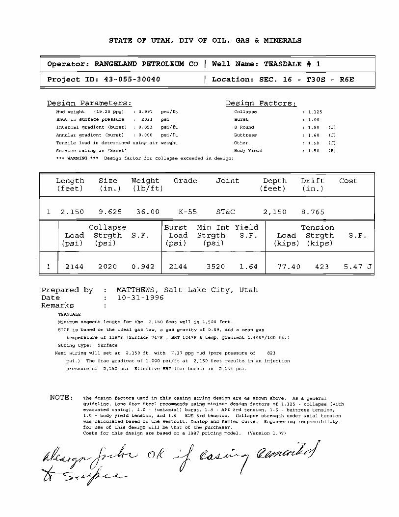
Collapse Burst Min Int Yield TensionLoad Strgth S.F. Load Strgth S.F. Load Strgth S.F.
(psi) (psi) (psi) (psi) (kips) (kips)
1 2144 2020 0.942 2144 3520 1.64 77.40 423 5.47 J
Prepared by : MATTHEWS, Salt Lake City, UtahDate : 10-31-1996Remarks :
TEASDALE
Minimum segment length for the 2,150 foot well is 1,500 feet.
SICP is based on the ideal gas law, a gas gravity of 0.69, and a mean gas
temperature of 116°F (Surface 74°F, BHT 104°F & temp. gradient 1.400°/100 ft.)
String type: Surface
Next string will set at 2,150 ft. with 7,37 ppg mud (pore pressure of 823
psi.) The frac gradient of 1.000 psi/ft at 2,150 feet results in an injection
pressure of 2,150 psi Effective BHP (for burst) is 2,144 psi.
NOTE : The design factors used in this casing string design are as shown above. As a generalguideline, Lone Star Steel recommends using minimum design factors of 1.125 - collapse (withevacuated casing), 1.0 - (uniaxial) burst, 1.8 - API Brd tension, 1.6 - buttress tension,1.5 - body yield tension, and 1.6 - EUE Srd tension. Collapse strength under axial tensionwas calculated based on the Westcott, Dunlop and Kemler curve. Engineering responsibilityfor use of this design will be that of the purchaser.Costs for this design are based on a 1987 pricing model. (Version
STATE OF UTAH, DIV OF OIL, GAS & MINERALS
Operator: RANGELAND PETROLEUM CO | Well Name: TEASDALE # 1
Prepared by : MATTHEWS, Salt Lake City, UtahDate : 10-31-1996Remarks :
TEASDALE
Minimum segment length for the 6,000 foot well is 1,500 feet.
SICP is based on the ideal gas law, a gas gravity of 0.69, and a mean gas
temperature of 116°F (Surface 74°F, BHT 158°F & temp. gradient 1.400°/100 ft.)
String type: Production
The mud gradient and bottom hole pressures (for burst) are 0.383 psi/ft and
2,297 psi, respectively.
NOTE: The design factors used in this casing string design are as shown above. As a generalguideline, Lone Star Steel recommends using minimum design factors of 1.125 - collapse (withevacuated casing), 1.0 - (uniaxial) burst, 1.8 - API Brd tension, 1.6 - buttress tension,1.5 - body yield tension, and 1.6 - EUE Brd tension. Collapse strength under axial tensionwas calculated based on the Westcott, Dunlop and Kemler curve. Engineering responsibilityfor use of this design will be that of the purchaser.Costs for this design are based on a 1987 pricing model. (Version
WORKSHEETAPPLICATION FOR PERMIT TO DRILL
APD RECEIVED: 09/25/96 API NO. ASSIGNED: 43-055-30040
WELL NAME: TEASDALE #1OPERATOR: RANGELAND PETROLEUM CORP (N8690)
1. ADMINISTERING STATE AGENCY 2. STATE APPLICATION IDENTIFIER NUMBER:OIL, GAS AND MINING (assigned by State Clearinghouse)1594 West North Temple, Suite 1210P.O. Box 145801Salt Lake City, Utah 84114-5801 3. APPROXIMATE DATE PROJECT WILL START:
October 30, 1996
4. AREAWIDE CLEARING HOUSE(s) RECEIVING STATE ACTIONS:(to be sent out by agency in block 1)Five County Association of Governments
5. TYPE OF ACTION: / / Lease IX/ Permit / / License /_/ Land Acquisition/ / Land Sale / / Land Exchange / / Other
6. TITLE OF PROPOSED ACTION:Application for Permit to Drill
7. DESCRIPTION:Rangeland Petroleum Corporation proposes to drill the Teasdale #1 well (wildcat) on state leaseML-46342, Wayne County, Utah. This action is being presented to RDCC for consideration of resource issuesaffecting state interests. The Division of Oil, Gas and Mining is the primary administrative agency in this actionand must issue approval before operations commence.
8. LAND AFFECTED (site location map required) (indicate county)NWl4, NWl4, Section 16, Township 30 South, Range 6 East, Wayne County, Utah
9. HAS THE LOCAL GOVERNMENT(s) BEEN CONTACTED?
10. POSSIBLE SIGNIFICANT IMPACTS LIKELY TO OCCUR:Degree of impact is based on the discovery of oil or gas in commercial quantities.
11. NAME AND PHONE NUMBER OF DISTRICT REPRESENTATIVE FROM YOUR AGENCY NEARPROJECT SITE, IF APPLICABLE:
12. FOR FURTHER INFORMATION, CONTACT: 13. SIGNATURE AND ITLE OF AUT RIZEDOFFICIAL:
Frank R. MatthewsPHONE: 538-5334 DATE: 10-15-96 Petroleum ngineer
RangelandTeasdale #1Sec, 16,T30S,R6E
DIVISION OF OIL, GAS AND MININGAPPLICATION FOR PERMIT TO DRILL
STATEMENT OF BASIS
Operator Name: Rangeland Petroleum Corporation
Name & Number: Teasdale #1
API Number:
Location: 1/4,1/4 NWNW Sec. 16 T. 30S R. 6E
Geology/Ground Water:
Casing program proposed should adequately protect any ground-water aquifers penetrated.Review of files for P&A's in this townshipshow that loss circulation could be a problem in thiswell. Several oil shows were reported but no high pressure zones. A review of Division of WaterRights database shows one water well in the townshipin section 31, several miles to thesouthwest of this well.
Reviewer: G. L. Hunt
Date: October 10, 1996
Surface:
Proposed location is on State Trust Lands. S&lTLA was notified of the onsite date and time, arepresentative did not participate. Part of the access road is on BLM administered land. A BLMrepresentative was present at the onsite. There are no private ownership issues concerning thislocation. A local rancher has been contacted concerning acquisition of water for drilling,documentation will be forwarded to the Division. They plan to run a water line along the existingroad way, a temporary use permit will be issued by the BLM for this.
Reviewer: G.L. Hunt
Date: October 4, 1996
Conditions of ApprovallApplication for Permit to Drill:
Reserve pit shall be lined with minimum 12 mil synthetic liner properly installed and maintained.
ON-SITE PREDRILL EVALUATION
Division of Oil, Gas and Mining
OPERATOR: Ranqefand Petroleum CorporationWELL NAME & NUMBER: Teasdale #1API NUMBER:
LEGAL WELL SITING: 460 F SEC. LINE; 460 F 1/4,1/4 LINE; 920 F ANOTHER WELL
GPS COORD (UTM):SURFACE OWNER: School and Institutional Trust Lands Administration (State)
PARTICIPANTS
Brian Wood-Permits West consultant for Rangeland, Gil Hunt-DOGM, Bruce Bonebrake-DWR, Kay Erickson-BLM.
REGIONALILOCAL SETTING & TOPOGRAPHY
This location is on Miners Mountain (Teasdale Anticline) between Capitol Reef National Park(Waterpocket Fold) to the east and Boulder Mountain to the west. The proposed site isalmost level with a very gentle slope to the southeast which is the head of Capitol Wash.
SURFACE USE PLAN
CURRENT SURFACE USE: Grazing, wildlife, prospecting, area has been logged in the pastall Ponderosa pines have been removed from the State section.
PROPOSED SURFACE DISTURBANCE: A drill pad of roughly 2 acres will be constructed.The area is almost level so little cut/fill is required. The pad area will require removal ofpinion-juniper trees which now exist there. Existing roads will be used except for a shortsection (~100')to be constructed on BLM land. A right-of-way will be obtained from BLM forthis and upgrade and use of the other portion of road on BLM administered land. Thesection of road on State land is already in place.
LOCATION OF EXISTING WELLS WITHIN A 1 MILE RADIUS: There are two plugged andabandoned wells in the area. One in NWNE of section 17, the other in the NWNE of section8 of the same townshipand range as the proposed well.
LOCATION OF PRODUCTION FACILITIES AND PIPELINES: If necessary will include 500bbl tanks for oil, a fiberglass tank for water, heater-treater, separators, and pumpjack, allpainted flat juniper green. Any tank battery will be bermed to contain possible spills.
RangelandTeasdale #1Sec. 16,T30S,R6E
SOURCE OF CONSTRUCTION MATERIAL: On location.
ANCILLARY FACILITIES: Trailers will be located on site for company men, mud logger, etc.
WASTE MANAGEMENT PLAN
Trash will be collected and hauled to the county landfill. Chemical toiletswill be used. Allwater and drilling mud will be kept on location and handled or treated as necessaryaccording to Division rules and guidance.
ENVIRONMENTAL PARAMETERS
AFFECTED FLOOD PLAIN ANDIOR WETLANDS: None to be affected.
FLORA/FAUNA: Pinion-Juniper, Broom Snake Weed, Indian Rice Grass, some small forbes,vegetation is very sparse except for Pinion-Juniper trees. Deer, wild turkeys, rabbits,raptors, rodents. DWR representative concerned about avoiding turkey roosting (Ponderosa)trees located along access route.
SOIL TYPE AND CHARACTERISTICS: Eolian sand, detritus from Sinbad LS, SS andLS fragments, bedrock exposed in some areas.
SURFACE FORMATION & CHARACTERISTICS: Triassic Moenkopi (Sinbad LimestoneMember) thin to medium bedded, brownish-orange and yellow conglomeratic and sandydolomite.
EROSIONISEDIMENTATIONISTABILITY: Flat and stable, minimal erosion mainly windcaused.
PALEONTOLOGICAL POTENTIAL: None observed.
RESERVE PIT
CHARACTERISTICS: Located on southeast corner of location, 100'x150'x10'.
LINER REQUIREMENTS (Site Ranking Form attached): 12 mil, 35 point ranking score.
SURFACE RESTORATIONIRECLAMATION PLAN
All areas not needed for production will be backfilled, recontoured to match natural contours,and reserved topsoil,trees, and brush evenly spread. Disturbed areas will be ripped,harrowed, or scarified before seeding. The south road which crosses the pad will be leftclosed and reclaimed. Areas widened by road upgrading will be similarly reclaimed. Allareas will be broadcast seeded in late fall or winter. DWR will provide a suitable seed mix.
RangelandTeasdale #1Sec. 16,T30S,R6E
SURFACE AGREEMENT
NA, Trust Land.
CULTURAL RESOURCES/ARCHAEOLOGY
Survey conducted by CASA (Mary Errickson), a copy will be provided. It will cover pipelineroute along existing roads as well as new disturbance.
OTHER OBSERVATIONSICOMMENTS
According to Ed Bonner (S&lTLA) Rangeland has not yet provided adequate bonding for thewell (10-9-96).
ATTACHMENTS
Liner ranking sheet, pictures, Water Rights points of diversion for the township.
n 95 152 .0000 .00 Sulphur CreekWATER USE(S): STOCKWATERINGUSA Bureau of Land Management P.O. Box 45155
n 95 4183 .0000 .00 Unnamed Intermittent StreamWATER USE(S): STOCKWATERINGState of Utah School & Institutional Tru 3 Triad Center, Suite 400 -- 3
1 UTAH DIVISION OF WATER RIGHTSNWPLAT POINT OF DIVERSION LOCATION PRO
MAP WATER QUANTITY SOURCE DESCRIPTION or WELL INFO POINCHAR RIGHT CFS AND/OR AC-FT DIAMETER DEPTH YEAR LOG NORTH
WATER USE(S): STOCKWATERINGState of Utah School & Institutional Tru 3 Triad Center, Suite 400 -- 3
o 95 184 .0000 .00 Chokecherry CreekWATER USE(S): STOCKWATERINGUSA Forest Service 324-25th Street
p 95 178 .0000 .00 Nixon Canyon CreekWATER USE(S): STOCKWATERINGUSA Forest Service 324-25th Street
q 95 4885 .0150 OR 1.26 6 100 - 500 N__ N 150WATER USE(S): IRRIGATION DOMESTIC STOCKWATERINGFerris, Ilene C. 2081 Wilmington
60f6
II
L
* I
r'
CES
$5 st t TempleMichael TÁadOe lley, Sulle 340
Te¢ Stew all t.akeCity, Utah 04180-1203
Executive IÑreter 01.ge-5340
James W. Carter 001-$59-3940(Fax)Division Director 601-538-5319 (TOD)
November 1, 1996
Rangeland Petroleum Corporation210 North Main StreetMidland, Texas 79701
Re: Teasdale #1 Well, 540' FNL, 660' FWL, NW NW, Sec. 16,T. 30 S., R. 6 E., Wayne County, Utah
Gentlemen:
Pursuant to the provisions and requirements of Utah CodeAxin. 40-6 1 et seq., Utah Administrative Code R649-3-1 et seq.,and the attached Conditions of Approval, approval to drill thereferenced well is granted.
This approval shall expire one year from the above dateunless substantial and continuous operation is underway, or arequest for,extension is made prior to the expiration date. TheAPI identification number assigned to this weil is 43-056-30040.
Sin erely,
Assóciä Directdr
andios esc: W¾yne Coun sesgdg
ufed fL hd änågeinent Richfiei bgs Biot ffi
eli Name &. Muttiber: Te¢ààie #‡API Númber: 43-05540040
Léase: ML-46340
Location: NR NW Sec. 16 T. 30 S. R. 6 E.
Conditions of Approval
1. GeneralCompliance with the requirements of Utah Admin. R..649-1 etseq., the Oil and Gas Conservation General Rules, and theapplicable terms and provisions of the approved Applicationfor Permit to Drill.
2. Notification RequirementsNotify the Division within 24 hours following spudding thewell or commencing drilling operations. Contact JimmieThompson at (801)538-5336.
Notify the Division prior to commencing operations to plugand abandon the well. Contact Frank Matthews at(801)538-5334 or Mike Hebertson at (801)538-5333.
3. Reporting RequirementsAll required reports, forms and submittals shall be promptlyfiled with the Division, including but not limited to theEntity Action Form (Form 6), Report of Wä6er EncounteredDuring Drilling (Form 7), Weekly Progresi Reports fordrilling and completion operations, and Sµndry Notices andReports on Ñelis requesting appròëal f dhange of plans orother operational actions.
4. Compliance with the Conditions-of ApprovalfApplication .for.
SUNDRY NOTICES AND REPORTS ON WELLS7 Unt Agreensatt Nene:
g...n.. se m.. merpop...I. m em n,....... a.,p...w.ung ...n., e, in ......« mune.eand - -a.
u.sMTKW FM PUMM O (WILLCA OgGPËN forta for auch peeposale
a wasnam..ng Numeer1 ***** 04 GAS OTHER:
TEA§D ALEa n... « op.m.« • weW.s ansia.e
RANGELAND PETROLEUM CORPORATION #1
a As ansangidsphone Nulnber: 14 ftaM and Wang, or WM:*
210 NORTH MAIN ST. , MIDLAND, TEXAS 7970] (915)686-891 3 WILDCAT
4 ww.u540' FNL fu 660 ' FWL WAYNE
*** NWNW16-308-6E UTAH
CHECK APPROPHIATEBOXES TO 1NDICATENtTURE OF NOTICE, REPORT, OR OTNERDATANOTICE OF INTENT SUSSEOUENT REPORT
O Abandon O New Construction O Abandon O New Conmoucdon
D Aspair casino O Pull or Alter casing O n.p.ir casing a Pullor Aaer casingO chang.esPs.n. O B•oompl•t• D changeof Plans O noperforsteO coewestto In¡ection 0 noperford• D convestto injection a ventor Flere
O FranhaeTreator Acidhe O VeMor Aare O Fracture Treat or AcW4e O Weer Shut-OW
O Mutiple Centplodon O Weier Shutar O Othergother CHANGE . TOTA.L DRPTH 'rn DR T i.f.
TO 8 , 900 '. Den of work oompi.tion
Approximale date work wel start. . .7 ANIIARY 19 9 7 n,,..,•••••« mumm•*-ra-en- and Wooom¢sdeem a dNasent lesensin onWELL
COMPLEngN OR REGOMPLEDONREPORT ANDLOG ima* tha be secomperded by a cessent voglicamientappia
12, OBIK2tBEPMDF GED08 COMPLETEDCPgnatoo icamenyem enpanksent asians,we goe pwynern desse a wou k elecfksnantmesa, she subestens bassens and measumr and onemesissi espSo br mi masse md -nos pelinert gr @damut)
Imag seetastruedanson neverse
01-12-91 09:40 RANGELAND EXPLORATION 031 PO2
RANGELAND PETROLEUMCORPORATION
2EASDAIÆ Well #1 , conunued Page 293fesse Maintain this Irgfomxation in Confidence]
12/26/96 TD: 40 AREMARKS: Continue to haul water to reserve pits as weather allows. Have hauled over
100 loads (approx. 10.500 bbis) & currently able to haul 5 or 6 loads per day, with sufHcient water onhand to begin drilling as soon as rig is available. (Per conversation with Nabors DrIg. anticipated move-in and rig-up for Nabors Rig 903 is December 29th}
Daily Cost: $1,000 To-Date Curn. Cost: 851,210
12/28/96 TD: 40 ApipMARKS:Continue to haul water to reserve pits. Currently waiting on Rig 903 & crews
to move-in. {Per conversation with Nabors Drlg, anticipated move-in for Rig 903 is Dec 31 & an approxdrilling date of Jan. 3.1997}
Daily Cost: 81,080 To-Date Cum. Cost: SO2.200
DAILY PROGRESS REPORTt[mi: Each report reflects a 24-hr mcord of operations from 7:00am the previous day to 7:00am on report day.
1/6/97 TD: 40 &REM¾¶: Reserve pit full, hauled 200+ loads. Met with Gary Hall assistant BLM area
manager on 1/3/97. Posted $2,500 reclamation bond & moved in three rig loads on 1/5/97. Haveapprox. 20 loads still to move. Expect to have all loads moved by 1/8/97 & begin rig up 1/8/97.
REMARKS: Limb additional trees along county road. Contact Kay Erickson with BLM &obtain permission to cut down one Ponderosa Pine tree. Move in 8 loads and continue to move in rig.
1 / 10 / 97 TD: 40 &REMARKS: Rigging Up. Waiting on main mud pump to be delivered to complete rig-up.
Anticipate drilling operations to begin this afternoon (1 / 10).Dany cost: 8250 To-Date cum.cost: sas,deo
1/11/97 TD: 40 ARygggg: Continue to wait on main mud pump. Pit liner appears to be leaking: water
level in pit dropped approx. 1 foot in last 24 hours. Hauled 9 loads water. Main mud pump arrived onlocation at 7:30 pm & mudloggers trailer delivered. Prep to complete rig up & commence drilling.
REMARES:Haul 1900bbt water to fill pit. RigUp mudiogger. Commence drilling e 9:30p1/11/97. Rotary table o 85rpm & mud motor o 12Orpm. Not using air & Hole began taking smillamount of fluid at 400 ft & Pumped a sawdust sweep.
DadU Cost· $7,700 To-Date Cum. Cost:
01-14-91 10: 35 RANGELAND EXPLORATION 012 PO2
RANGELAND PETROLEUMCORPORATION
TEASDALE WeM #1 , conunued Page 3IPlease Maintain this Infomiation in Confidence]
REMARKS: Started mudlogging Sunday afternoon. Roughnecks catching 30' samples.Inst returns at 900'. Start adding air at 900 efm. got back 80% returns. Started snowing at 6:00 p.m.and reserve pit was full. (Approx.19.000 bbis in reserve, Shut down water haulers. Inst completereturns at 1150' (9:00 p.m.) Increased air to 1800 efm, pump rate to 325 bpm. No returns and noattempt to mud up was made. Dry drilled thru the night to 1485'. Estimated 2.000 bbis left in reserveat report time. WIII msume water hauling as soon as access road is cleared of snow. (Snowed 3 feetover night.)
6'DC: MW: Not Available: Pump#1: 6x16. SPM: 55; Press: N/A: Hourly Summary: 2.4 Drilled and10% 1485' -1543', 0.5-Circulate, 8.5-TOH for bit. 8.0 fight lost circulation, mix 100 bbl pill w/40 vislßM and pump down backside. Butid volume and mix mud in steel pits and pre mix tank. (40 vis w/15% LCM, 8.5- Stand back 8° DC and mud motor and TlH. 1.0- Try to break circulation. Drul stringplugged. 4.0. 'IDH wet. Clean out 45' drill collars plugged w/ LCM, TIH to 800'. 1.4 Try to breakcirculation. Drill string plugged., 0.5-'II)H wet.
REMgŒS: Began blading snow on access road at 2:00 p.m. Had road to locationpassable by 6:00 p.m. Broke blade off of motor grader on second pass thru on access road. Snowedadditional 10 inches overnight. Try to locate another motorgrader. Access is still impassable to watertrucks.
Daß¾ Cost: $1,250 To-Date Currt Cost: $71,800
210 N. Main St.• Midland, Texas 79701• (915) 686-8983 • Fax (915)
DJ. 1.0 ) I D.J f J ODINGELOINU EAri_Unn I lUIN CVJi Vidd
RANGELAND PETROLEUMCORPORATION
TEASDMS Well #1 , contmoed Page 4JPfeuse Maintain this lofomiation in Conßdence]
(Sat) Progress: 44'; Present Oper: Drtg Insert Float: Formation: LIME: BIT #3: 12 1/4" &I,C SF2DOpen Jets; WOB; 45: RPM: 120; ROP: 22; Com Hrs: 69: BHA: Same: MW: Water; Vise:-; PV:-; YP:-;PH: Pump#1: 6x16. SPM;45; AIR: none; Press: 0-350; Hourly Summary: 2.O-Dr1g 2350'-2394', 3.4Mix Mud & Pump 400 bbl Pill, 1.50-Strap Out of Hole, 2.6- Rig Up Csg crew & run 9-5/8° Csg. 4.O·Rig Up BJ & Casing Plugged, 1.O·Rig Down BJ & Back Off Top Jt Csg, 9.O-Rig Up to drill out pluggedesg. 1.0- Drlg out insert float & guide shoe
REMARKS: Drill 2350° 2394' without returns. TD surf hole @ 2394'. Strap out (2389.3°)& mix 400 bbl mud w/ 60 vis, 15% LCM. Spot pill on btm. POH & run guide shoe, 1 Jt csg, insertfloat,& 55 Jts csg. (total 56 Jts new 9-5/8° 36#/ ft K55 STC esg to 2394.89 ft). Ran centralizers on Jts.1.3.5.7,9,11 & ran cmt baskets on jts 34 & 43. Landed csg @ 2354' & could not wash esg down & csgplugged. Pressured to 1700 psiw/ no success. Rig down cementers & ran 7-7/8' bit, mud motor, drillcollars & drill pipe in esg to drill out float. Now drilling on guide shoe.¯
Dafly Cost: 32.910 To-Dgfe Cum. Cost: 883,4151/19/97 TD: 2394'; (Day 8)(Sun) Progress: O'; Present Oper: WOC ; Formation: LIME; Hourly Summary: 3,5-Drill out guideshoe, g.0-Walthig on Welder 2.0-Tylp_Og, 0.5- Lay Down landing joint & PU 1 Jt 9-5/8". 0.5-Rig Up BJ & Circulate, 1.5-Cement Casing, 1.5-Wait on Cmt, 1,5- Run 1" down annulus & pump 50sx Cmt to surface, 10.0- WOC & wait on baseplate
REMARKS:Drill out guide shoe & pump down esg for 20 mins. TOH. Land shoe at 2360'& Rig up BJ & cmt casing w/ 635sx 50/50 Poz(12.6ppg) w/6%gel, 2% CaCl, 1/4pps cellaflake& 2#/skKolscal (groundrubber). Tail in w/175 sx Class G(t5ppg) w/ 2% CaCI & l /4pps cellallake. Flush w/174 BW & I ft 50' cmt in casing. No returns during cementing. Rig up 1" tbg & pump 50 sx Class G(15ppg) w/ 3% CaCI down backside. Cement to surface. WOC. Prep to weld on wellhead & baseplate.Hauled 19 loads water to pRs (1800 bbls).
Dafy Cost: $2,660 To-Date Cum. Cost: $86,07ð1/20/97 TD: 2394': (Day 9)(Mon) Progress: O'; Present Oper: PREP TO CEMENT ; Formation: LIME; HourlY Summary: 1.0-WOC, 9.0-Cut off conductor pipe and 9-5/8" esg., weld on. 5.0-NUBOP, 2.5-T1H, 2.O-Wash to 238T ,
1.5-3DH, 0,5-TIH open ended to cement shoe, 2.5- Rig up BJ and WOOREMARKS: Drill out wiper plug at shoe. Washed down to 2375' w/ good circulation-no
air. Lost returns at 2375'. 900 psi, standpipe pressure. Washed to 238T and circulate. Lost estimated600 bbla., POH and lay down bit, RIH open ended. Prep to pump air down 9-5/8" esg. to displace fluidin hole.Hauled 21 loads water.
Daify Cost: $2,700 To-Date Cum. Cost: 888,775
210 N. Main St.• Midland, Texas 79101•(915) 686-8983 • Fax (915)
01-24-91 11:21 RANGELANDE×PLORATION 346 PO2
RANGELAND PETROLEUMCORPORATION
TEASDAIB Well #1 , conunued Page 6IPlease Maintain this Ir¡forrnation in Confidence]
1/21/97 TD: 239& : (Day 10)(Tues) Progress: O'; Present Oper: TIH ; Formation: LIME; BIT #4: 8 3/4" Reed HPSIA Jets: 3/ 14: INO 2394' WOB: RPM: ROP; Cum Hrs:: BHA: Bit. 6-l/2" MM, 17 6-1/4" DC, 3- HWDP (641.5'); MW: Wtr;Visc:-; PV:-; YP:-; PH; Pump#1: Oxl6, SPM:; AIR; none: Press:; Hourly Summary: 2.GDisplace holewlair & pump 225 sks cmt. 1.4TOH. 10.5-WOC, 3.0-TIH, tag top of cmt at 2115', break circ. & TOH,8.5.WOC, 1.411H w / bit
REMARKS:Pump 1900 cfm air down 9-5/8' esg while pumping 34 bols, cement down4·1/2" DP. Shut off air & pump 10 bbis. cement & open bypass to bleed pressure off casing. Pump 10bbla. cement & 6 bbls. flush. Shut down & 'IDH w/ DP, Pumped total of 225 sks. Class G w/ 1% CaCl.Rig down BJ & WOC 12 hrs., RlH & tag top of cement at 2115', WOC 6.5 hrs. RIH wi bit & BHA &prep to drill out. Call dozer to push snow off road. Road is sloppy as water truck slid off road & gotstuck in snow bank. Hauled 19 loads water a mudlogger on standby last 3 days.
Daily Cost: 82,990 To-Date Cum. Cost: .$91.785
1/22/97 TD•2640': (Day 11)(Wed) Progress: 246'; Present Oper: DRID ; Formation: LIME/SS ; BIT #4: 8 3/4" Reed HPSIA Jets:3/14: IN O 2394' WOB: 25-30; RPM:20 (MM 112); ROP:49; Cum Hrs:: BHA: Bit, 6-1/2" MM, 17 6-1/4"DC. 3- HWDP (641.5'); MW: Water; Visc:-; PV:·: YP:-: PH: Pump#1: 6x16, SPM:52; Press:1000: MSummary: 2.0-Tag top of cement at 2115', cement soft,, 7.5-WOC. 2.O-Drill soft cement to 2320'.0.8 Test pipe rams to 1500psi. 1.5-Strap out of hole, 0.54Test blind rams 1500psi. 1.4 'HH, 4.0-Drilled good cement to 2294', 5.4 Drilled 2294'-2454' w/ water only, getting good returns. Drilled2454' to 2640 w/1800 cfm air and used one cup of foamer with each drill pipe connection.-
REMARitS: Hauled 20 loads water to location, pit almost fullDagy Cost· $2,690 To-Date Cum. Cost: $94,455
1/23/97 TD: 3528': (Day 12)(Thurs) Progress: 888'; Present Oper: DRLO W/ OUT RETURNS, Formation: LIME/DOLO; BIT #4: 83/4" Reed HPSIA Jets: 3/14; OUT @3244' Bit #5: 7-7/8° Hughes AD446 Jets 3/14 In O 3244';WOB:25-30: RPM:20 (MM N/A); ROP:55; Cum Hrs:15; BHA: Bit. 7- 7/8'. MM, 17 6-1/4' DC, 3- HWDP; MW:Water: Vise:-; PV:-: YP:-: PH: Pump#1: 6xl6. SPM:28; Press:350; Hourly Summary: 2.0-Drill 2640' to2753', aerate w/1200 efm.0.54Rig service and operate pipe rams. 8.5-Drill 2753' to 3244' w/ outreturns, 0.04WLS. 2.5-Strap out of hole, 3.O-Mix LCM pill and pump down hole, 1.5-11H. 5.5-Drill3244' to 3528'.
REMARKS:Surveys: 6-1/4 deg @ 3244': Lost returns at 2753' at 8:00 a.m. Drilled wloutreturns to 3244°. TOH and mixed 250 bbl. pill w/45 vise,, 25 sks cedar fiber, 15 sks sawdust, 20 sksmaxisaal, 20 sks nutshells, 20 shredded paper sacks and rope strands. Pump pill down hole and wait30 minutes, flush w/ 150 bbis water. No pressure increase. TIH and continue drilling w/out returns,estimated top of fluid o 2900'. Hauled 15 loads water, began hauling w/ two trucks O 2:00 a.m.
Daßy Cost: $3,190 7b-Date Cum. Cost: $97.648
1/24/97 TO:4268': (Day 13)(Fri) Progress: 740': Present Oper: THI; Formation: Cambrian Lynch: Bit #5: 7-7/8" Hughes AD446Jets 3/14 In e 3244';WOB: 25-30; RPM:40 ROP;55; Cum Hrs:15: BHA; Bit. 7- 7/8", MM. 17 6-1/4"DC, 3- HWDP: MW: Water: Visc:-; PV:-: YP:-: PH: Pump#l; 6xl6, SPM:28; Press: 350; MSummary: 2.0-Drill 3528° to 3646, 5.4 Drill 3646' to 3833'. 0.54 WLS, 9.4 Drill 3833' to 4266', 4.6TOH and try to unplug motor, 2.5-LD mud motor and prepare to stifT foam, 1.4 71H.
REMARKS: Surveys: 6- deg o 3833', 4-1 /2 deg @4266; Drilled from 3528' to 4268'without returns. Plugged mud motor w/walnut hulls from pre-mix tank. TOH and laid down mudmotor.11H and prepare to stiff foam to try to get circulation. Lincoln hauled 21 loads, Dalbo hauled 20loads.
Daily Cost: $3,500 To-Date Cum. Cost: $101.236
210 N. Main St.• Midland, Texas 79701 •(915) 686-8983 • Fax (915)
01-29--91 11: 31 RANGELAND EXPLORATION SO1 PO2
RANGELAND PETROLEUMCORPORATION
TRASDALE WeU #1 , conteued Page 6IPlease Maintain this Ir¡forruztfon in ConJ1dence)1/26/97 TO: 4860'; (Day 14)(Sat) Progress: 588'; Present Oper: DRLG: Formation: Cambrian(no returns): Bit #5: 7-7 /8" HughesATJ446 Jets 3/14 In @ 3244';WOB: 40; RPM:60 ROP:30 fph; Cum Hrs:40: BHA: Bit, 17 6-1/4' DC, 3-HWDP; MW: Foam;Vise:-:PV:.;YP:.: PH: ; Mist Pump Only, SPM: : Press: : Hourly Summary: 2.O-TIH.2.5.Mix & Pump stiff foam, 0.54Ream 4176' to 4266 .
17.O-Drill 4266' to 480T. 0.5-Rig Service, 1,5-Drill 480T to 4856
REMARKS: Mix 20 gals foamer. 5 gals DC305 w/ 25 bbls 40vis mud in mist tank &inject down drili string e 8 bph & l 100-1400cfm air. Drilled w / no returns on stiff foam. Stand pipepressure @ 300-500 psi. Hauled 31 loads wtr to reserve pit. Surveys: None
Daily Cost: 83,410 To-Date Cum. Cost: $104,648
1/26/97 TD. 6666'; (Day 15)(Sun) Progress: 799'; Present Oper: DRLG; Formation: Cambrian?(no retums); Bit #5: 7-7/8" HughesATJ446 Jets 3/14 in @ 3244',Out e 5052'; Cum Hrs:46.5: Bit #8: 7-7/8° Hughes ATJ446 Jets 3/18WOB: 30: RPM:70/110; ROP:50 fph;; BHA: Bit#6,MM, 17 6-1/4" DC, 3- HWDP: MW: 8.5:Vise:42:PV:12;YP:8; PH:11.5:Pump #1: 6Xl6', SPM:28: Press:250-350#; Hourly Summary: 2.0-Drill 4856' to489T, 4.5-Drill 489T to 5052', 2.5-TOH. O.5-Rig Service, 2. PU Mud Motor & TlH, 3.5-Drill 5052° to5195', O.S.WL Survey. 8.5-Drill 5195' to $655',
REMARK : Mud up @5052'. Pump 4.4 hpm 40+ vis mud & 2000cfm air. No returns.Rigup H2S monitors @ shaker & rig floor. Continue hauling wtr to reserve pit. Surveys: 1 deg 65195'
Daily Cost: $4,150 To-Dute Cum. Cost: $108.798
1/27/97 TD:6093'; (Day 16)(Mon) Progress: 438'; Present Oper; MAKE UP TEST TOOLS: Formation: Sandstone: Bit #6: 7-7/8"Hughes ATJ446 Jets 3/18 WOB: 30; RPM:70/110: ROP:62 fph: BHA: Bit.MM, 17 6-1/4" DC, 3-HWDP: MW: 8.5;VIse: 42: PV: 12:YP: 8: PH: 11,5;Pump #1: 6X16", SPM:28; Press:250-350#: MSummary: 2,O-Drill 5655' to 6093', 0.5-WL Survey, 1. Short trip, 12 stands, no flll, 1.4 Cire w/ a40 vis mud, spot 100 bbls. (80 vis mud on bottom), 3,4Chain & strap out of hole. Lay down motor.(strap 6096'). 1.0- RU loggers, 6.0- Run E-logs, 3.0- WO DST tools, 1.4 Make up test tools.
REMARKS: TD well at 6093' at 1 pm 1/26/97. Condition hole & run CNL-FDC, DIL, ML,Could not get DIL below 6063', Prepare to run DST#1 fmm 5950' to 6096'. (Should have tool out ofhole approx. 7 pm)
Daily Cost: S483,760 To-Date Cum. Cost: .$592,555
1/28/97 TD: 6096'; (Day 17)(Tues) Progress: 0°: Present Oper: DST: Formation: Sandstone: Hourly Summary: 3.5-TIH w/ testtool, tag fill @ 6033' , 1.O-Work pipe from 6033' to 6063'. 2.5-Chain out 25 stds & 'lUH, 1.0.LD testtools, 2.4Plck up bit & TIH, tag fill o 6021'. 1.4 Ream & wash 6021' to 6096', 0.00- Circulate onbottom e 4.4 bpm w/ 1100 cfm air. 1.0-Short trip.12 stands, 2' fill on bottom. 1.4 Circulate onbottomw/ water & air, spot 100 bbis mud on htm w/ no air, 3.0-TOH, 1.O· Make up test tool, 2.5-TlH, 4.4DST 5950' to 6096'.
REMARKS: Running Dslyt i from 5950' to 6096. Recoverd 60' GCM and 1022' SW InDP (40,000 ppm) sample chamber-.54 ef gas and .800 cc water (40,000 ppm) intial floW -227#, intialshut in-lO98#, final flow-446#, final shut In-1124#
1.0-Cut drlg line. 2.0-TIH, 1.WHit tight spot @ 5940'.Ream and wash to bottom, 0.6 Circulate on bottom, 1,O-Short trip. 12 stands, no fl11,1.5-Pump 100bble of40 vis mud on bottom. 8.O· 'IUH, 4.0-Pick up test tool and TIH, 3.5- DST
REMARKS: NONEDaßy Cost: SI 3,500 To-Date Cum. Cost: $620.595
210 N. Main St.•Midland, Texas 79701•(915) 686-8983•Fax (915)
01-30-9'l 09:4G RANGELAND EXPLORATION 549 PO2
RANGELAND PETROLEUMCORPORA TION
TRASDAfÆ Well #1 , contmued Page 7[Pfense Mairttain this Ir¡formation in CorlJidenceJ
1/28/97 TD:0000'; (Day 17)(Tue) Pogoss; O'; Present Oper: DST: Formation: Sandstone: Hourly Summary: 3.5-TlH w/ testtool. tag flll @ 6033' , 1.0-Work pipe from 6033' to 6063'. 2.5-Chain out 25 stds & TOH, 1.& LD testtools, 2.0-Pick up bit & TIH, tag till @ 6021'. 1. Ream & wash 6021' to 6096', 0.54 Circulate onbottom @ 4.4 bpm w / 1100 cfm air, 1.0-Short trip, 12 stands, 2' 111]on bottom, 1.O· Circulate onbottom w/ water & air, spot 100 bb1s mud on htm w/ no air. 3.0-TOH, 1. Make up test tool, 2.5-11H. 4. DST 5950' to 6096'.
REMARKS: Running DST#1 from 5950° to 6096. Recoverd 60° GCM and 1022' SW inDP (40,000 ppm) sample chamber-.54 ft gas and 800 cc water (40,000 ppm) intial 11ow-227#, intialshut in-1098#, final flow-446#. final shut in-1124#
Dagy Cost: 814,540 To-Date Cum. Cost: $607,0951/29/97 TO:8090'; (Day 18)(Wed) Progress: O':Present Oper: DST #2: Formation; Sandstone; Hourly Summary: 1.5-DST #1.4.5- Pull tool free & TOH. O.50-TIH w/ bit , 1. Out drlg line, 2.O-TIH, 1. Hit tight spot o 5940'.Ream & wash to bottom, 0.54Circulate on bottorn. I.O-Short trip, 12 stands, no fill, 1.5-Pump 100bble of 40 vis mud on bottom. 3.& TOH. 4,4Pick up test tool & TlH. 3.5- DRIW2
REMARKS:DSIW2 from 5905' - 6096'; Recovered 10ft drilling mud, 860ft salt water indrillpipe (40,000 ppm). Initial Flow 77-210# in 30 Inins, initial Shut-in: 1080# in 60 mins. Final Flow:271-387# in 60 mins. Final Shut.In: 1101# in 3 hours. Sample Chamber: 1.07 ft" gas, I250cc saltwater. No apparent hydrocarbons during Tapaats test. Rccommend PXA of Tapeats well. Release rig toConoco e 12 noon 1/29/97. FINAL REPORT
Dady Cost: $2,000 To-Date Cum. Cost: $622,595
210N. Main St.•Midland, Texas 79701 •(915) 686-8983•Fax (915)
01-18-91 15:04 RANGELANDE×PLORATION 151 PØ3
RANGELAND PETROLEUMCORPORATION
January 18, 1997
teF UktahM emGasDivision
1594 West North Temple, Ste. 1210Salt Lake City, UT 84114(sent via FAX 1/18/96 801-359-3940)
RE: Confidentiality of Teasdale Welt #1Wayne County, UtahRangeland Petroleum Corp.
Mr. Matthews,
Thank you for your recent message regarding the procedures required tomaintain the subject well in confidencc. We do hereby request that theinformationsupplied to you regarding the Teasdale #1 be kept confidentialfor thepresent dme. Thank you again for your assistance.
Respectfully,
MichaelJ. DanielVice-President
210 N. Main St. • Midland, Texas 79701 • (915) 686-8983 • Fax (915) 686-7911
43-OST S0°sí
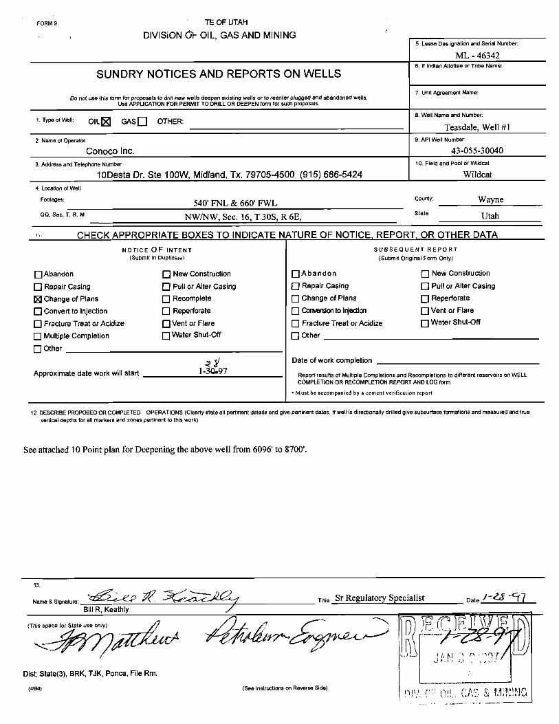
FORM 9 TE OF UTAH
DIVISiON01-OIL, GAS AND MININGS. Lease Des ignation and Serial Number:
ML - 463426. If Indian Allottee or Tribe Name:
SUNDRY NOTICES AND REPORTS ON WELLS
Do not use this form for proposals to drill new wells deepen existing wells or to reenter plugged and abandoned wells7. Unit Agreement Name:
Use APPLICATION FOR PERMIT TO DRILL OR DEEPEN form for such proposals.
8. Well Name and Number:1. Type ofWell: OIL GASD OTHER:
Teasdale, Well #12. Name of Operator: 9. API Well Number
Conoco Inc. 43-055-30040
3. Address and Telephone Number: 10. Field and Pool or Wildcat:
10Desta Dr. Ste 100W, Midland, Tx. 79705-4500 (915) 686-5424 Wildcat4. Location of Well
Footages: 540' FNL & 660' FWL county: WayneQQ, Sec, T. 8. M NW/NW, Sec. 16, T 30S, R 6E, stat" Utah
CHECK APPROPRIATE BOXES TO INDICATE NATURE OF NOTICE, REPORT, OR OTHER DATANOTICEOF INTENT SUBSEQUENT REPORT
(Submit in Duplicate) (Submit Original Form Only)
O Abandon New Construction A b a ndon New Construction
O Repair casing O Pull or Alter casing O Repair casing O Pull or^iter casingChange of Plans Recomplete Change of Plans Reperforate
O convertto injection O Reperforate O Comon to Injdon Vent or Flare
O Fracture Treat or Acidize O Vent or Flare Fracture Treat or Acidize Water Shut-Off
O Multiple Completion O Water Shut-Œf Other
O Other
Date of work completion
Approximate date work will start I-SÛ•9Report results of Multiple Completions and Recompletions to different reservoirs on WELLCOMPLETION OR RECOMPLETION REPORT AND LOGform.
• Must be accompanied by a cement verification report
12. DESCRIBE PROPOSED OR COMPLETED OPERATIONS(Clearly state all pertinent details and give pertinent dates. If well is directionally drilled give subsurface formations and measured and truevertical depths for all markers and zones pertinent to this work)
See attached 10 Point plan for Deepening the above well from 6096' to 8700'.
me & Signature: Titie Sr Regulatory Specialist Date
Casing Coverage Slurry Weight Volume Type & Adatives(#/gal)
Surface 0 - 1860' Lead 12.1 635sx 50:50 Poz (50% Poz:50%Class G + 2%CACL2 +
.25#/sx cello flake + 2 #/sxKolscal + 6% Gel
1860 - 2360' Tail 15.6 175sx Claas G + 2%CACL2 +
.25#/sx cello flake
Prod 5300-8700' Tail 16.2 700sx Class H + 3#/sx gilsonite +
cuft .25#/sx cello flake + .5%
FL-62
Note: 1. Actual Cement Volumes will be calculated from caliper logs.
6. Pressure Control Equipment:
A. BOP: 3000 psi w.p. Double ram blowout preventer with appropriate extensionhandwheels to 8700'. The pipe rams will be on top and blind rams on the bottom.
B. A function test and visual inspection of the BOP will be performed daily.
C. BOP equipment will be tested at least every 14 days. The BOP and casing test willconform to Onshore order No. 2.
7. Auxiliary Equipment:
A. Kelly cock
B. Drill pipe float
C. Visual monitoring of the mud system.
D. Rotating head
8. Variance Request:
A. Conoco request a variance from the requirement to use a straight run blooie line.Where possible a straight blooie line will be used. Where it is not possible, any teesor ells in the lines will be
DRILLING PLANTreasdale #1January 27, 1997Page 3
9. Drilling Fluids Program:
Interval Mud Type Density Funnel Viscosity Water Loss(Ib/gal) (Sec/Qt)
DIL/GR/Sonic/LDT/CNL from TD to 6092'Dipmeter - 5480 to TDRotary Sidewall Cores - As per Geologist
B. No Cores planned
C. Possible DST in the Carbon Butte Sandstone
D. Final determination of the completion interval will be made by analysis of logs.
E.. Directional control shall be maintained by running a drift shot survey after every1,000' of drilling.
11. Abnormal Pressure or Temperatures: Potential Hazards.
A. Lost circulation is possible throughout wellbore.
12. Additional Information:It is Conoco's intention to bury the cuttings on location once the pit has evaporated
DOUBLE RAM TYPE PREVENTERS WITH ROTATING HEADC3ÒOO ps! System)
Flow LineF111Line
L_ I
RHI
I I
A
IR )
Adjustoble ChokeTo PIT 8/or Mud/Gos Seocratcr
2" MinimumBlowout PreventerStock Quttet 2"
ChokeLine Bleed Line To PitKill ChcKe
Line Line2" Minimum
I \ 2" MinimumI I 2"
2" MinimumAdlustoble Choke
Minimum BOP Stock 3000 psi Working Pressure
One Plpe Aom .100&L ps! Working Pressure -
One ellnd Acm 3000 psi Working Pressure
One Annular .30ûtL psi Working Pressure
Well Head 3000 psi Working Pressure
Manifold 10ûlL ps! Working Pressure
Rotating Head JiߣL psl Working Pressure
Divisina of Oil, Gas and Mining Rou n /
OPERATOR CHANGE WORKSHEET
Attach all documentation received by the division regarding this change. .MM- $$.Initial each listed item when completed. Write N/A if item is not applicable. 4-VI,D 9-Fif,E
W Change of Operator (well sold) O Designation of AgentO Designation of Operator O Operator Name Change Only
The operator of the well(s) listed below has changed, effective: 1-28--97
TO: (new operator) CONOCO INC FROM: (old operator) RANGELAND PETROLEUM CORP
(address) 10 DESTA DR STE 100w (address) 210 N MAIN STMIDLAND TX 79705-4500 MIDLAND TX 79701
Phone: (915) 686-5424 Phone: (915)686-8983
Account no. NO260 Account no. NB690
WELL(S) attach additional page if needed:
Name: TEASDALE 1/DRL API: 43-055-30040 Entity: 99999 S _16_ y 305 RS Lease: ML46342
Name: API: Entity: S T R Lease:Name: API: Entity: S T R Lease:Name: API: Entity: S T R Lease:Name: API: Entity: S T R Lease:Name: API: Entity: S T R Lease:Name: API: Entity: S T R Lease:
OPERATOR CHANGE DOCUMENTATION
l. (r649-8-10) Sundry or other legal documentation has been received from the FORMER operator (attach to thisform)· (&S |-zi17)
2. (r649-8-10) Sundry or other legal documentation has been received from the NEW operator (Attach to thisform). (i /-27†?
3. The Department of Commerce has been contacted if the new operator above is not currently operating anywells in Utah. Is the company registered with the state? (yes/no) If yes, show company file number:
4. FOR INDIAN AND FEDERAL WELLS ONLY. The BLM has been contacted regarding this change. Makenote of BLM status in comments section of this form. BLM approval of Federal and Indian well operatorchanges should ordinarily take place prior to the division's approval, and before the completion of steps 5through 9 below.
5. Changes h ve been entered in the Oil and Gas Information System (3270) for each well listed above.
6. Cardex file has been updated for each well listed above. (2-3-T7)
7. Well file labels have been updated for each well listed above. (2-1-Ñ8. Changes have been includedon the monthly "Operator, Address, and Account Changes" memo for distribution
to Trust Lands, Sovereign Lands, UGS, Tax Commission, etc· (2-3-77)
9. A folder has been set up for the Operator Change file, and a copy of this page has been placed there forreference during routing and processing of the original documents.
\dons\wpdocs\forms\operchng- OVER
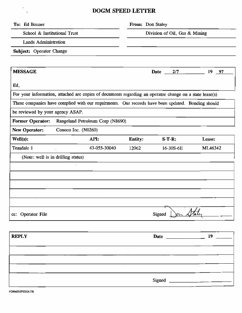
DOGM SPEED LETTER
To: Ed Bonner From: Don Staley
School & Institutional Trust Division of Oil, Gas & Mining
Lands Administration
Subject: Operator Change
MESSAGE Date 2/7 19 97
Ed,
For your information, attached are copies of documents regarding an operator change on a state lease(s)
These companies have complied with our requirments. Our records have been updated. Bonding should
be reviewed by your agency ASAP.
Former Operator: Rangeland Petroleum Corp (N8690)
New Operator: Conoco Inc. (NO260)
Well(s): API: Entity: S-T-R: Lease:
Teasdale 1 43-055-30040 12062 16-30S-6E ML46342
(Note: well is in drilling status)
cc: Operator File
Signede
REPLY Date 19
Signed
FORM 9 o I ATE OF UTAH
DIVISiONOF OIL, GASAND MINING5. Lease Des ignation and Serial Number
ML - 463426. If Indian A11otteeor Tribe Name:
SUNDRY NOTICES AND REPORTS ON WELLS
Do not use this form for proposals to drill new wells deepen existing wells or to reenter plugged and abandoned wells7. Unit Agreement Name:
Use APPLICATION FOR PERMIT TO DRILLOR DEEPEN form for such proposals.
8. Well Name and Number:1 Type of Well: OIL GAS Q OTHER
Teasdale, Well #12 Name of Operator 9. API Well Numbec
Conoco Inc. 43-055-30040
3 Address and Telephone Number 10. Field and Pool or Wildcat:
QQ, Sec, T. R. M NW/NW, Sec. 16, T 30S, R 6E, state Utah
CHECK APPROPRIATE BOXES TO INDICATE NATURE OF NOTICE, REPORT, OR OTHER DATANOTICE OF INTENT SUBSEQUENT REPORT
(Submit in Duplicate) (Submit Original Form Only)
O Abandon O New Construction O A b a ndon O New Construction
O Repair Casing O Pull or Alter Casing O Repair Casing O Pull or Alter Casing
O Change of Plans O Recomplete O Change of Plans O Reperforate
O convertto injection O Reperforate Comon to I ection Vent or Flare
O Fracture Treat or Acidize O Vent or Flare O Fracture Treat or Acidize Water Shut-Off
O Multiple Completion O Water Shut-Off O Other
Other Change OperatorDate of work completion
Approximate date work will start Report results of Multiple Completions and Recompletions to different reservoirs on WELLCOMPLETION OR RECOMPLETION REPORT AND LOG form.
•Must be accompanied by a cement verification report
12 DESCRIBE PROPOSED OR COMPLETED OPERATIONS (Clearly state all pertinent details and give pertinent dates. If well is directionally drilled give subsurface formations and measured and truevertical depths for all markers and zones pertinent to this work)
Conoco Inc. will take over as Operator, of the above listed well from Rangeland Petroleum Corporation effective 14. 2 Ÿ , 1997,in order to complete the well from 6092' to a new TD of 870'.
Conoco hereby assumes full responsibility for compliance with the terms and conditions of the lease for operations conducted upon the leasedlands. Bond coverage is provided under Conoco's Utah Statewide Bond.
DIVOF OIL, GAS& MINING
ame & Signature: Titie Sr Regulatory Specialist Date
BillR, Keathly
(This space for State use only)
Dist; State(3), BRK, TJK, Ponca, File Rm.
(4\94) (See instructions on Reverse
FORM 9 -, (ATE OF UTAH
DIVISiONOF OIL, GAS AND MINING5. Lease Des ignation and Serial Number
ML - 463426. If indian Allottee or Tribe Name:
SUNDRY NOTICES AND REPORTS ON WELLS
Do not use this form for proposals to drill new wells deepen existing wells or to reenter plugged and abandoned wells7. Unit Agreement Name:
Use APPLICATION FOR PERMIT TO DRILLOR DEEPEN form for such proposals.
8. Well Name and Number:1. Type of Well: OIL CR Q OTHER:
Teasdale, Well #12. Name of Operator 9. API Well Number
Rangeland Petroleum Corporation 43-055-30040
3. Address and Telephone Number 10. Field and Pool or Wiidcat:
210 North Main ST., Midland, Tx. 79701 (915) 686-8983 Wildcat4. LocalJon of Well
Footages: 540' FNL & 660' FWL County: Wayneoo, see, I R. M NWINW, Sec. 16, T 30S, R 6E, stat Utah
CHECK APPROPRIATE BOXES TO INDICATE NATURE OF NOTICE, REPORT, OR OTHER DATANOTICE OF INTENT SUBSEQUENT REPORT
(Submit in Duplicate) (Submit Original Form Only)
O Abandon Q New Construction Q A ba ndon O New Construction
O Repair Casing Pull or Alter Casing Repair Casing Pull or Alter Casing
O Change of Plans O Recomplete Change of Plans Reperforate
O convertto injection O Reperforate Monto Injedian Vent or Flare
O Fracture Treat or Acidize O Vent or Flare Fracture Treat or Acidize Water Shut-Off
O iviuitiplecompletion O Water Shut-Off OtherOther Change Operator
Date of work completion
Approximate date work will start Report results of Multiple Completions and Recompletions to different reservoirs on WELLCOMPLET10N OR RECOMPLETION REPORT AND LOG form.
• Must be accompanied by a cement verification report
12 DESCRIBE PROPOSED OR COMPLETED OPERATIONS (Clearly state all pertinent details and give pertinent dates. If well is directionally drilled give subsurface formations and measured and truevertical depths for all markers and zones pertinent to this work)
Rangeland Petroleum Corporation will turn over Operatorship of the above listed well to Conoco Inc effective o A f , 1997,to allow for the drilling from the present TD of 6092' to a new TD of 8,')00'.
Conoco agrees to assume the responsibility for the terms and conditions of the lease for operations conducted upon the leased lands.
me a signature: VI Title Vice President Date / e 7
(This space for State use only)
J AN 2 0 297
(4\94) (See Instructions on Reverse Side)
DN.OFOIL,GASSt
AV510011lL, GAS AND H1NING OPERATOR CONOCO INC OPERATOR ACCT. No. N 0260
ENTITY ACTION FORM- FORM 6 ADDRESS
ACTION CUInlENT NEW API NUMBER WELLNAHE WFil lOCATIDM SPUD EFFECTIVECODE ENTITY NO. ENTITY NO. QQ SC TP RG COUNTY DATE DATE
A 99999 12062 43-055-30040 TEASDALE 1 NWNW 16 30S 6E WAYNE 12-14-96
WELL 1 COMMENTS:
WELL 2 CONHENTS:
WELL 3 COHNENTS:
WELL 4 COMMENTS:
I | |WELL 5 CONHENTS:
ACTION CODES (See instructions on back of form)A - Establish new entity for new well (single well only) L. CORDOVA (DOGM)D - Add new well to existing entity (group or unit well) SignatureC - Re-assign well from one existing entity to another existing entity ADMIN. ANALYST 2-3-97O - Re-assign well from one existing entity to a new entityE - Other (explain in connents section) . Title Date °
NOTE: Use COMMErlT section to explain why each Action Code was selected. Phone No. ( )
QQ, Sec T. 8. M NW/NW, Sec. 16, T 30S, R 6E sta** Utah
CHECK APPROPRIATE BOXES TO INDICATE NATURE OF NOTICE, REPORT, OR OTHER DATANOTICE OF INÏENT SUBSEQUENT REPORT
(Submit in Duplicate) (Submit Original Form Only)
OAbandon New Construction Abandon New Construction
O Repair Casing Pull or Alter Casing Repair Casing Pull or Alter Casing
O Change of Plans Recomplete Change of Plans Reperforate
O Convert to Injection Reperforate Convemon to Injedian Vent or Flare
O Fracture Treat or Acidize Vent or Flare Fracture Treat or Acidize Water Shut-Off
O Multiple Completion Water Shut-Off Other Spud, set surface esg
O Other
Date of work completion 1-20-97
Approximate date work will start Report results of Multiple Completions and Recompletions to different reservoirs on WELLCOMPLETION OR RECOMPLETION REPORT AND LOG form.
* Must be accompanied by a cement verification report
12. DESCRIBE PROPOSED OR COMPLETED OPERATIONS (Clearly state all pertinent details and give pertinent dates. If well is directionally drilled give subsurface formations and measured and truevertica! depths for all markers and zones pertinent to this work)
Rangeland Petroleum spudded this well on 1-12-97. Drilled a 12 1/4" hole to a depth of 2394'. GIH W/ 56 jts 9 5/8" 36#, K-55 ST&C esgset @2360'. Shoe set @2360'. Lead slurry 635 sx 50/50 Poz + 6% gel + 2% CsCl2 + 1/4#/sx cellaflake + 2#/sx Kolscal. Tail slurry 175 sxClass 'g'cmt + 2% CaCl2 + 1/4#/sx cellaflake. Flush W/ 174 bbl water, left 50' cmt in esg, no returns. Rig up 1" tbg & pump 50 sx Class 'G'+ 3% CaCl2 down backside, cement to surface. 1-22-97 continue drilling 7 7/8" hole, to a total depth of 6096', shut down drilling and turnover operation to Conoco Inc. on 1-28-97, to complete to a depth of 8700'.
13ame
& Signat Titie Sr Regulatory Specialist Date 3-4-97
(This space for State use only)
Dist; State(3), BRK, TJK, Ponca, File Rm.
(4\94) (See Instructions on Reverse
FORM 9 NTE OF UTAH
DIVISiONL 31L, GAS AND MINING5. Lease Des ignation and Serial Number:
ML - 463426. If Indian Allottee or Tribe Name:
SUNDRY NOTICES AND REPORTS ON WELLS
Do not use this form for proposals to drill new wells deepen existing wells or to reenter plugged and abandoned wells7. Unit Agreement Name:
Use APPLICATION FOR PERMIT TO DRILL OR DEEPEN form for such proposals
8. Well Name and Number:1 Type of Well: OIL GASD OTHER:
3 Address and Telephone Number: 10. Field and Pool or Wiidcat:
10Desta Dr. Ste 100W, Midland, Tx. 79705-4500 (915) 686-5424 Wildcat4 Location of Well
Footages: 540' FNL & 660' FWL County: Wayneoo, see, T R. M NW/NW, Sec. 16, T 30S, R 6E stat" Utah
CHECK APPROPRIATE BOXES TO INDICATE NATURE OF NOTICE, REPORT, OR OTHER DATANOTICEOF INTENT SUBSEQUENT REPORT
(Submit in Duplicate) (Submit Original Form Only)
O Abandon New Construction Abandon New Construction
O Repair Casing Pull or Alter Casing O Repair Casing Pull or Alter Casing
O Change of Plans Recomplete O Change of Plans Reperforate
O convertto injection O Reperforate O ConvemontoInjection O Vent or Flare
O Fracture Treat or Acidize Vent or Flare Fracture Treat or Acidize O Water Shut-Off
O Multiple Completion O Water Shut-Off Other Drill to TD
O Other
Date of work completion 2-9-97
Approximate date work willstart Report results of Multiple Completions and Recompletions to different reservoirs on WELL
) NFiDENTlAOR C ON ANDLOGform.
12. DESCRIBE PROPOSED OR COMPLETED OPERATIONS (Clearly state all pertinent details and give pertinent dates If well is directionally drilled give subsurface formations and measured and truevertical depths for all markers and zones pertinent to this work)
1-30-97 Conoco Inc assumed operations of this well. Continue drilling 7 7/8" hole from 6096' to 8700'. Total depth reached on 2-7-97.
Received verbal approval from Gil Hunt with the State of Utah Division of Oil, Gas & Mining to plug and abandon well.
Rig up BJ, pump 150 sx Class 'G' balanced plug from 5705' to 6205', POOH. GIH set 9 5/8" cement retainer @2308', Sting in retainerpump 170 sx Class 'G' cmt, 100# psi during squeeze, sting out leave 2 bbi slurry on top of retainer. Spot 20 sx class 'G' cmt from 60' tosurface, good plug. Well is plugged and abandoned.2-9-97 released rig @6 am.
13ame
& Slgnature Titie Sr Regulatory Specialist Date3-4-97
BillR, Keathly
(This space for State use only)
Dist; State(3), BRK, TJK, Ponca, File Rm.
(4\94) (See Instructions on Reverse
FORM8STATE Of UTAH
DIVISION OF OIL, GASAND MINING s. LEASE DESIGNATION AND SERIAL NO.
ML - 463426 I) INDIAN.ALLOTTBB OR TRIBE NAME
WELL COMPLETION OR RECOMPLETION REPORT AND LOGIa.TYPEOFWELL: os AsLL
DRY - 7.UNITAOREEMENTNAME
b TYPE OF COMPLETON:N oER NEF LUCoK
RESVR. Other 8 FARM OR LEASE NAME
2. NAME OF OPERATOR TCSSdale
ConocoInc. 9.WELLNO.
3.ADDREssOFOFERATOR
10 Desta Dr. Ste 100W, Midland, Tx. 79705-4500 10. FIELD AND POOL, OR WILDCAT
4. LOCATIONOF W ELL (Report location cicarly and in accordance with any State Requirements) WildcatAt surface 540' FNL & 660' FWL 11. SEC., T., R., M., OR BLOCK AND SURVEY
om AREA
At top prod. interval reported below
^ · •r • NW/NW Sec. 16, T 30S, R 6E
??/LET SE F TrMW '"^
3-055-30040DATEISSUED 12.COUNTY 13.STATE
15. DATE SPUDDED 16. DATE T.D. REACHED 17 DATE COMPL. (Readv to prod.) 18. ELEVATIONS (DP, RKB, R , GR, ETC.) 19. ELEV. CASINGHEAD
FLOW.TUBINGPRESS. CASINGPRESSURE T o it a no. GAS--McF. WATER-BBL olt onAvlTY Arl(conx.)
| |34 DISPOSTION OF GAS (Sold, used for fuel, vented.etc) TEsT WITNESSED BY
35 LIST OF ATTACHMENTS
Logs & Pipmeter36. I hereby certify tilat the foregoing and attached inform ation is com I t a d correst as determined from all available records
SIGNE T IT LE DATEBillR. Keathly
See Spaces for A dditional Data orr IVeverst Side
(318 9) STATE(3), BRK, TJK, LAND, PONCA, WELL
I NSTRUCT10NS
This form should be completed an compliance with the Utah Oil and Gas Conservation General Rules. If not filed prior to this time all logs,tests and directianal surveys as required by Utah Rules should be attached and submitted with this report.ITEM 18. Indicate which elevation IS used as reference for depth measurements given in other spaces on this form and on any attachments.ITEMS 22 and 24: If this well is completed for separate production from more than one interval zone (multiple completion) so state in item 22
and in item 24 show the producing interval or intervals top(s) bottom(s) and nane(s) for only the interval reported in item 33. Submit aseparate report (page) on this form adequately identified for each additional interval to be separately produced showing the additional datapertinent to such interval.ITER 29: Sacks Cement : Attached supplemental records for this well should show the details of any multiple stage cementing and the location ofthe cerœnting tool.ITEM 33: Submit a separate copletion report an this form for each interval to be separately produced (see instruction for items 22 and 24 above) .
37. SUMMRY Of POROUS2ŒES: 38. GEOLOGIC MARKERSShow all important zones of porosity and cantents thereof; cored intervals;and all drill-stem tests including depth interval tested cushion usedtime tool ppeµ. g).gwinc and shut-in pressures. arx1 reæveries.
Formation '[pp Bottom Description. contents. etc. Name .
11 CHECK APPROPRIATE BOXES TO INDICATE NATURE OF NOTICE, REPORT, OR OTHER DATANOTICE OF INTENT SUBSEOUENT REPORT
(Bubmn in DupUcete) (submmOriginsi Form Only)
O Abandon O New Construction O Abandon O New Construction
O Repair casing O Puli or Aner casing O Repair casing O Pull or Aner casingO Change of Plans O Recomplete O Change of Plans O Reperforate
O convertto injection O Reperforate O convertto injection O ventor Flare
O Fracture Treat or Acidize O ventor Flare O Fracture Treat or Acidirp O Water Shut-Off
O Multiple Completion O Water Shut-Off O Other Ragnact for honrl relapse
O otherDate of work completion N/A
Approximate date work will start Aaport mouts of Mumi¢e e-¢ - and --Ø-•*- k>dmetent meelvatreen WELLCOMPLERON OR AECOMPLEDON AEPORT NO LOG k
* Must be accompanted by a cementwortlicadon report
11 DESCASE PADPOSED OA COMPLBED OPERUKNIS (Ctmady stale all gnent M and give pertinent dates. Wwell is directionally ddlied, ghe subsurface locadons and measuredand truevertical dap@as ior al maricatsand zones perdnent io this work.)
The Teasdale #1 was drilled to a depth of 6096' by Rangeland Petroleum. Conoco assumed operations of the wellon 1/29/97 and drilled the well to a depth of 8700'. Conoco plugged the well as a dry hole on 2/9/97. It is ourunderstanding that Conoco completed the location restoration in April of 1997.
Rangeland herebyrequests a release of its well bond for the Teasdale #1. Conoco's statewide bond will cover anyfuture operations since Conoco has replaced Rangeland as Operator.
Iwwell P Braxton 801-S$9.3940(Fax)Divimon Direuer $Qt-538-7223(TOO\
UTAH DIVISION OF OIL, GAS AND MININGFACSIMILE COVER SHEET
DATE: JUNE 10, 1998
FAX#: 355-0922
ATTN: ED BONNER
COMPANY: SITLA
DEPARTMENT:
NUMBER OF PAGES (INCLUDING THIS ONE)
From: LISRA CORDOVA
If you do not receive all of the pages, or if they are illegible,please call
State of UtahDEPARTMENT OF NATURAL RESOURCESDIVISION OF OIL, GAS AND MINING1594 West North Temple, Suite 1210
Michael a PO Box 145801
Ted Stewart Salt Lake City, Utah 84114-5801
Executive Director 801-538-5340
inwell P Braxton 801-359-3940 (Fax)Division Director 801-538-7223 (TDD)
UTAH DIVISION OF OIL, GAS AND MININGFACSIMILE COVER SHEET
DATE: JUNE 10, 1998
FAX#: 355-0922
ATTN: ED BONNER
COMPANY: SITLA
NDEPARI'MINT
AGES (INCLUDING THIS ONE)
From: LISHA CORDOVA
If you do not receive all of the pages, or if they are illegible,please call (801)538-5340.
We are sending from a sharp facsimile machine. Our telecopiernumber is (801)359-3940.
MESSAGES:
*OPERATOR REQUEST FOR BOND RELEASE;I HAVE NOTIFIED RANGELAND PETRO. CORP.
THAT THEIR REQUEST FOR BOND RELEASE WAS BEING SENT TO SITLA. (SEE ATTACHED)
Important: This message is intended for the use of the individual or entity of which it is addressedand may contain information that is privileged, confidential and exempt from disclosure underapplicable law. If the reader of this message is not the intended recipient, you are hereby notifiedthat any dissemination, distribution, or copying of this communication is strictly prohibited. if youhave recieved this communication in error, please notify us immediately by telephone and returnthis original message to us at the above address via regular postal service. Thank
OPERATOR: CONOCOLEASE NAME : TEASDALEWELL NO: 1TEST NO: 3TESTED INTERVAL: 8069.30 - 8700.00 ft
FIELD AREA: WILDCATCOUNTY/LSD: WAYNESTATE/PROVINCE: UTAHCOUNTRY: USA
NOTICE: THIS REPORT IS BASED ON SOUND ENGINEERING PRACTICES, BUTBECAUSE OF VARIABLE WELL CONDITIONS AND OTHER INFORMATION WHICH MUSTBE RELIED UPON HALLIBURTON MAKES NO WARRANTY, EXPRESS OR IMPLIED ASTO THE ACCURACY OF THE DATA OR OF ANY CALCULATIONS OR OPINIONSEXPRESSED HEREIN. YOU AGREE THAT HALLIBURTON SHALL NOT BE LIABLE FORANY LOSS OR DAMAGE, WHETHER DUE TO NEGLIGENCE OR OTHERWISE ARISINGOUT OF OR IN CONNECTION WITH SUCH DATA, CALCULATIONS OR
TABLE OF CONTENTS
SECTION 1: TEST SUMMARY & INFORMATION
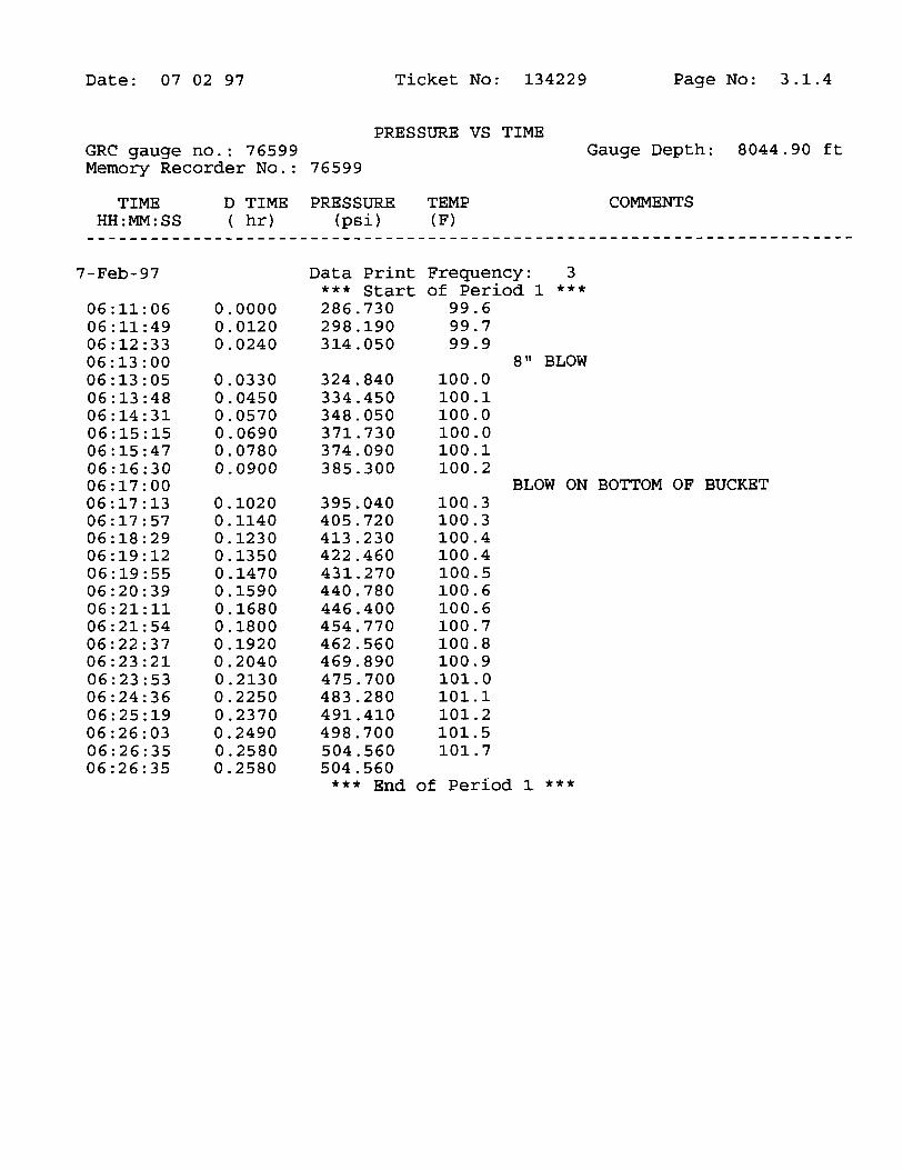
Swamary of Test Results 1.1Test Period Summary 1.2PreSaure vs. Time Plot 1.3Test and Formation Data 1.4Rate History Täble 1.5Tool String Configuration 1.6Operator Job Log 1.7
SECTION 3 : MEMORY GAUGE DATA
Gauge No. 76599
SECTIO
N
Date: 07 02 97 Ticket No: 134229 Page No: 1.1
SUMMARY OF TEST
Lease Owner: CONOCO Lease Name: TEASDALE
Well No.: 1 Test No.: 3
County/LSD: WAYNE State/Province: UTAH
Country: USA
Formation Tested: PRECAMB. GRAN.
Hole Temp: 105.00 F
Total Depth: 8700.00 ft
Net Pay: 64.00 ft
Gross Teated Laterval: 8069.30 - 8700.00 ft
Perforated Interval (ft):
RECOVERY:
2509 FT. (30.5 BBLS) OF TOTAL FLUID RECOVERED558 FT. (8 BBLS) OF MUD CUT WITH WATER1951 FT. (22.5 BBLS) OF FORMATION FLUID
REMARKS:
COULD NOT LOAD HOLE, BECAUSE OF A LOSS ZONE. COULD NOT SEEFLUID ON ANNULUS DURING
Date: 07 02 97 Ticket No: 134229 Page No: 1.2
TEST PERIOD SUMMARY
Gauge No.: 76599 Depth: 8044.90 ft Blanked off: No
ID PERIOD DESCRIPTION PRESSURE (psi) DURATION (min)
A Initial Hydrostatic 2099.48B 1 Start Draw-down 286.73C End Draw-down 504.56 15.48C 2 Start Build-up 504.56D End Build-up 2002.95 33.30E 3 Start Draw-down 540.96F End Draw-down 1086.29 90.36F 4 Start Build-up 1086.29G End Build-up 2028.61 181.80H Final Hydrostatic 2080.51
CHOKE SURFACE GAS LIQUIDTIME SIZE PRESSURE RATE RATE REMARKS
HH:MM:SS (in) (psi) (Mscf/D) (bbl/D)
6-Feb-9720:00:00 ON LOCATION22:30:00 PICK UP TOOLS23:45:00 START EMR GAUGE #76599
7-Feb-9700:35:00 START TOOL IN HOLE04:15:00 TAG BOTTOM AND RIG UP SUR. EQP04:45:00 WAIT ON DAYLIGHT06:08:00 TOOL TAKING WEIGHT06:11:00 TOOL OPEN WITH 4" BLOW06:13:00 8" BLOW06:17:00 BLOW ON BOTTOM OF BUCKET06:29:00 30" BLOW, CLOSE TOOL IN07:01:00 OPEN TOOL WITH 14" BLOW07:16:00 25" BLOW07:25:00 8/64 1.00 OPEN THRU CHOKE07:31:00 8/64 1.00 OPEN THRU CHOKE07:46:00 8/64 1.00 OPEN THRU CHOKE08:01:00 8/64 1.00 OPEN THRU CHOKE08:16:00 8/64 1.00 OPEN THRU CHOKE08:31:00 8/64 1.00 CLOSED TOOL IN11:32:00 OPEN BY-PASS12:00:00 START OUT OF HOLE15:40:00 DROP BAR TO DRAIN DRILL PIPE16:15:00 TOOLS AT SURFACE19:00:00 TOOLS LOADED19:30:00 JOB
SECTIO
N
Date: 07 02 97 Ticket No: 134229 Page No: 3.1
TEST PERIOD SUMMARY
Gauge No.: 76599 Depth: 8044.90 ft Blanked off: No
ID PERIOD DESCRIPTION PRESSURE (psi) DURATION (min)
A Initial Hydrostatic 2099.48B 1 Start Draw-down 286.73C End Draw-down 504.56 15.48C 2 Start Build-up 504.56D End Build-up 2002.95 33.30E 3 Start Draw-down 540.96F End Draw-down 1086.29 90.36F 4 Start Build-up 1086.29G End Build-up 2028.61 181.80H Final Hydrostatic 2080.51
Because of the uncertainty of variable well conditions and the necessity of relyingon facts and supporting services fumished by others, Halliburton is unable to guar-antee the accuracy of any chart interpretation, research analysis, job recommen-dation or other data furnished by Halliburton. Halliburton personnel will use theirbest efforts in gathering such information and their best judgement in interpretingit but customer agrees that Halliburton shall not be responsible for any damagesarising from the use of such infonnation except where due to Halliburton grossnegligence or willfulmisconduct in the preparation or furnishing of information.